Projected Changes in Intra-Season Rainfall Characteristics in the Niger River Basin, West Africa

Abstract
:1. Introduction
2. Study Area, Data and Method
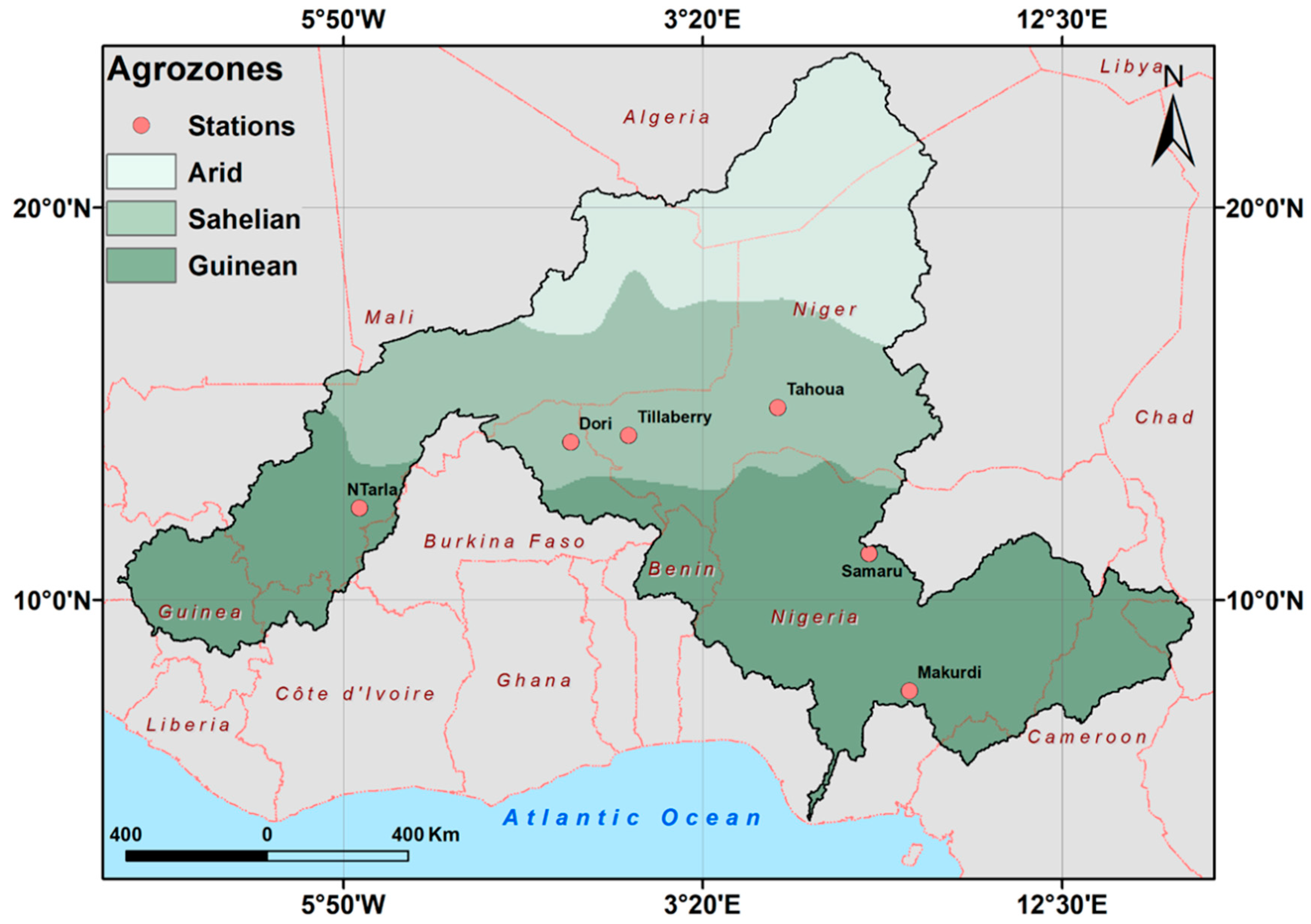
2.1. Study Area
2.2. Conceptual Framework and Data
2.3. Data
2.4. Methods
2.5. Onset, Cessation and Duration of the Rainy Season
2.6. Daily Rainfall Frequency and Intensity Analysis
3. Results and Discussion
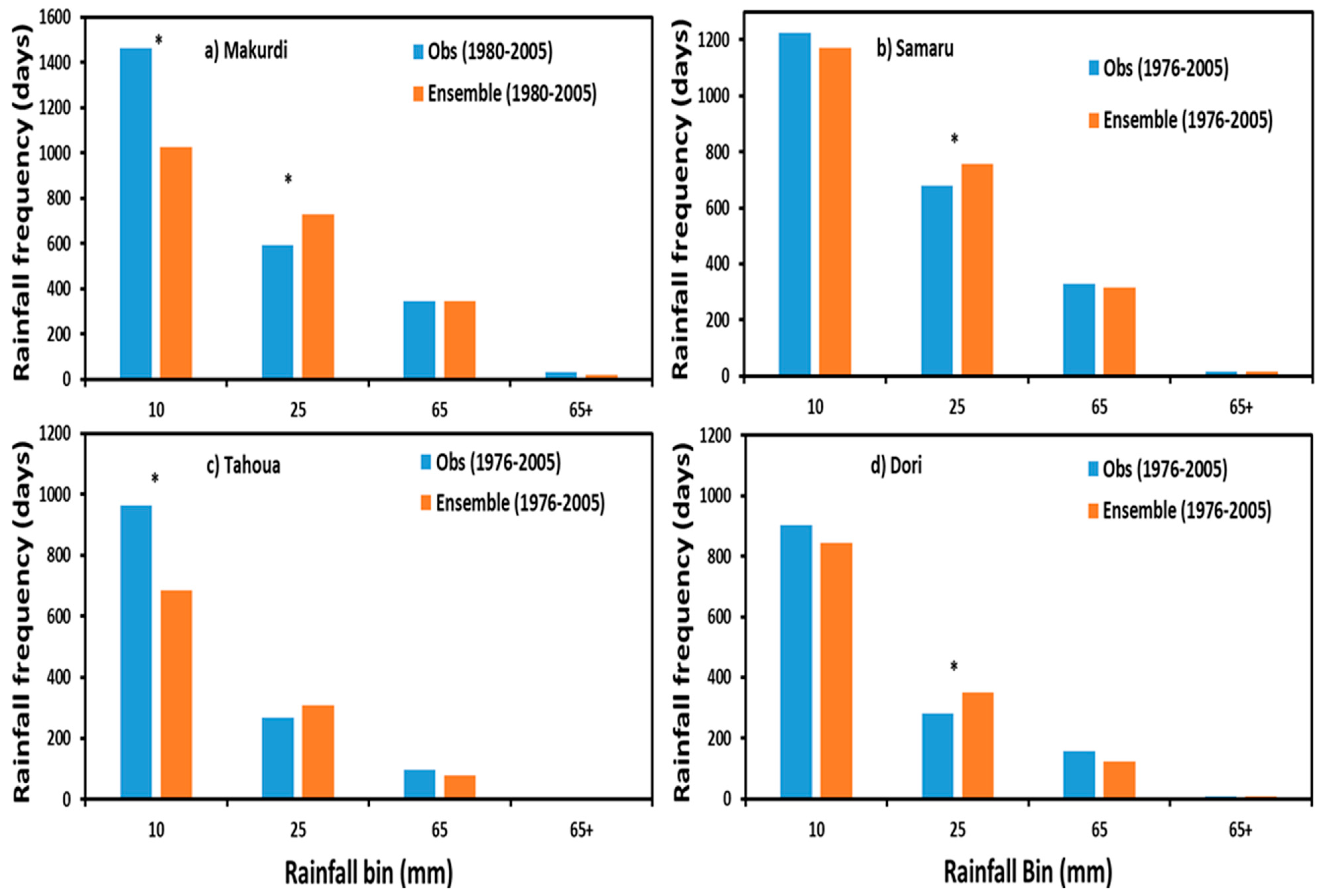
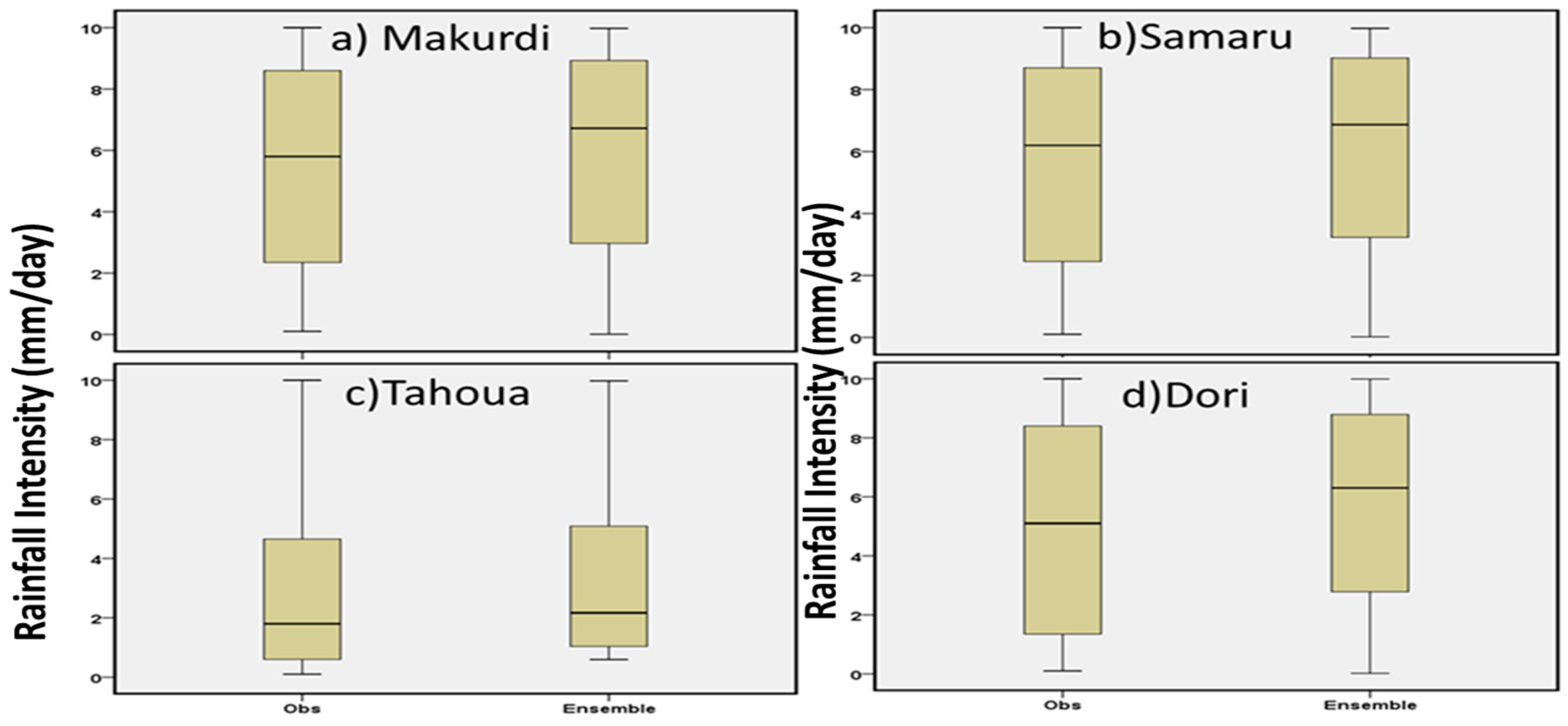
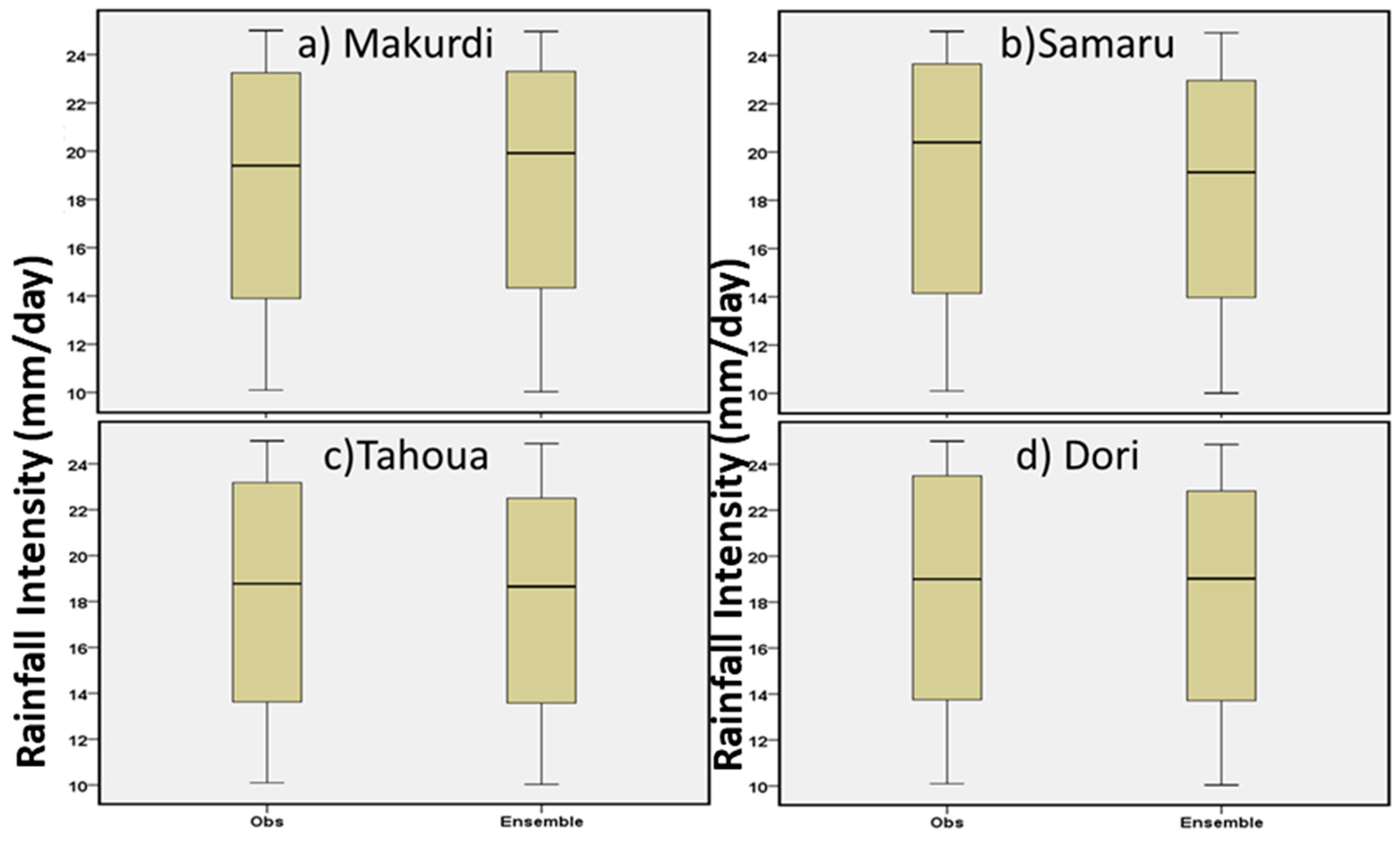
3.1. Evaluation of the Simulated Rainfall for the Historical Period
- i).
- The variance of the ensemble simulated and observational data is statistically significantly different for annual total rainfall, onset, cessation (but not in the Sahel), and duration of season.
- ii).
- The variance of the ensemble simulated and observed rainfall intensities is similar in the low, moderate and high intensity categories but statistically significantly different in the extreme rainfall category.
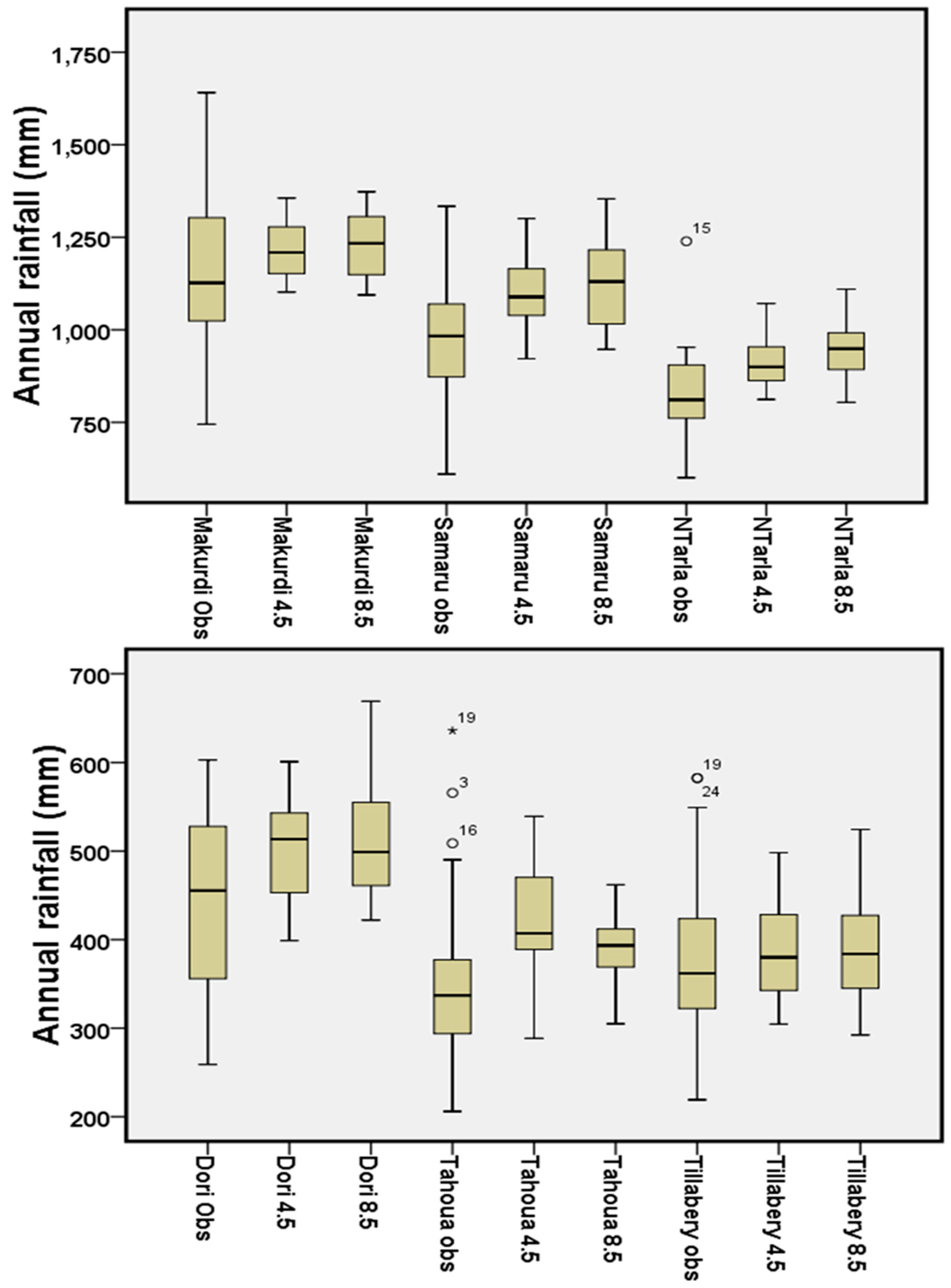
3.2. Future Rainfall Characteristics in the Niger River Basin
3.2.1. Seasonal Rainfall Pattern
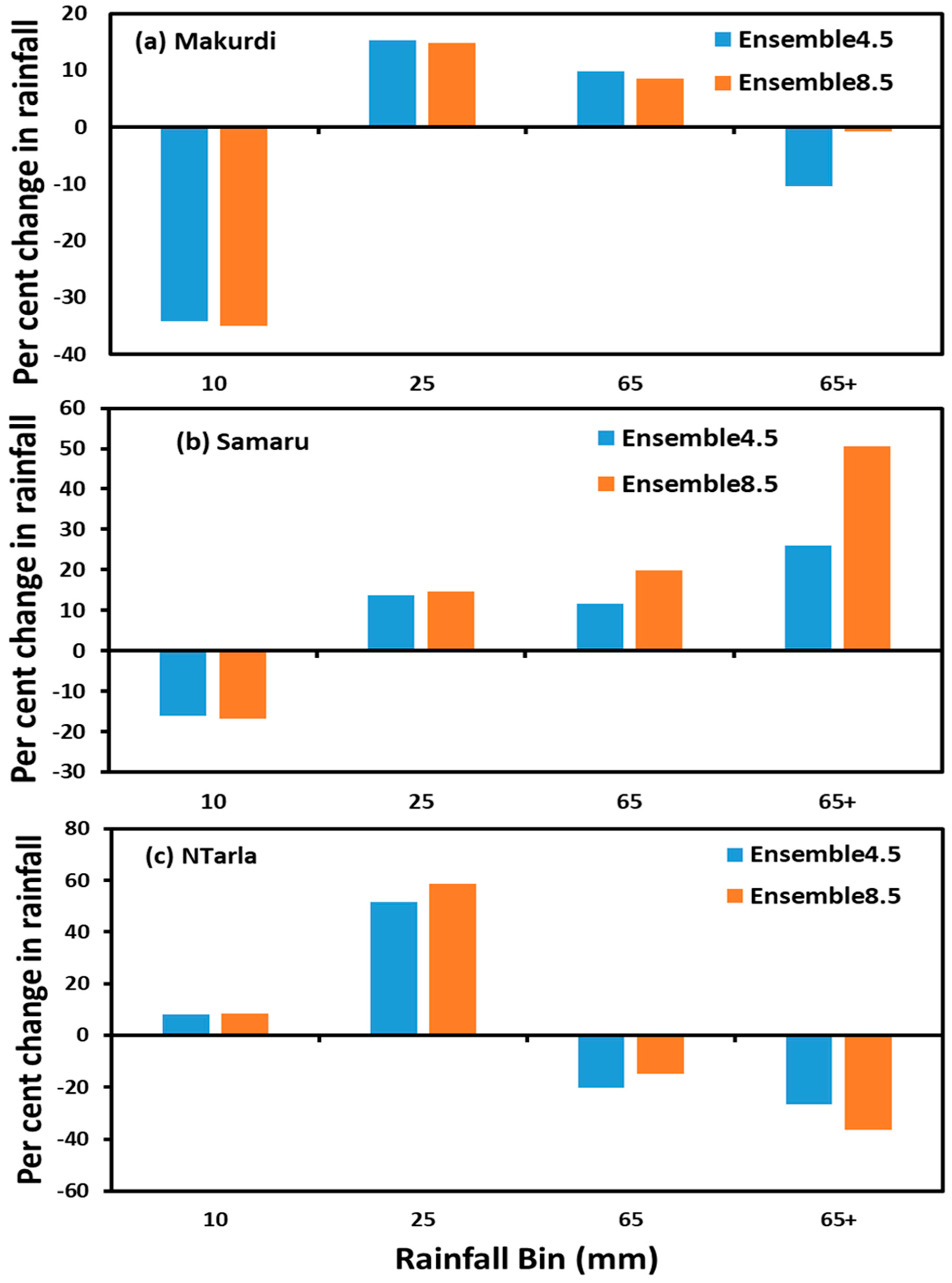
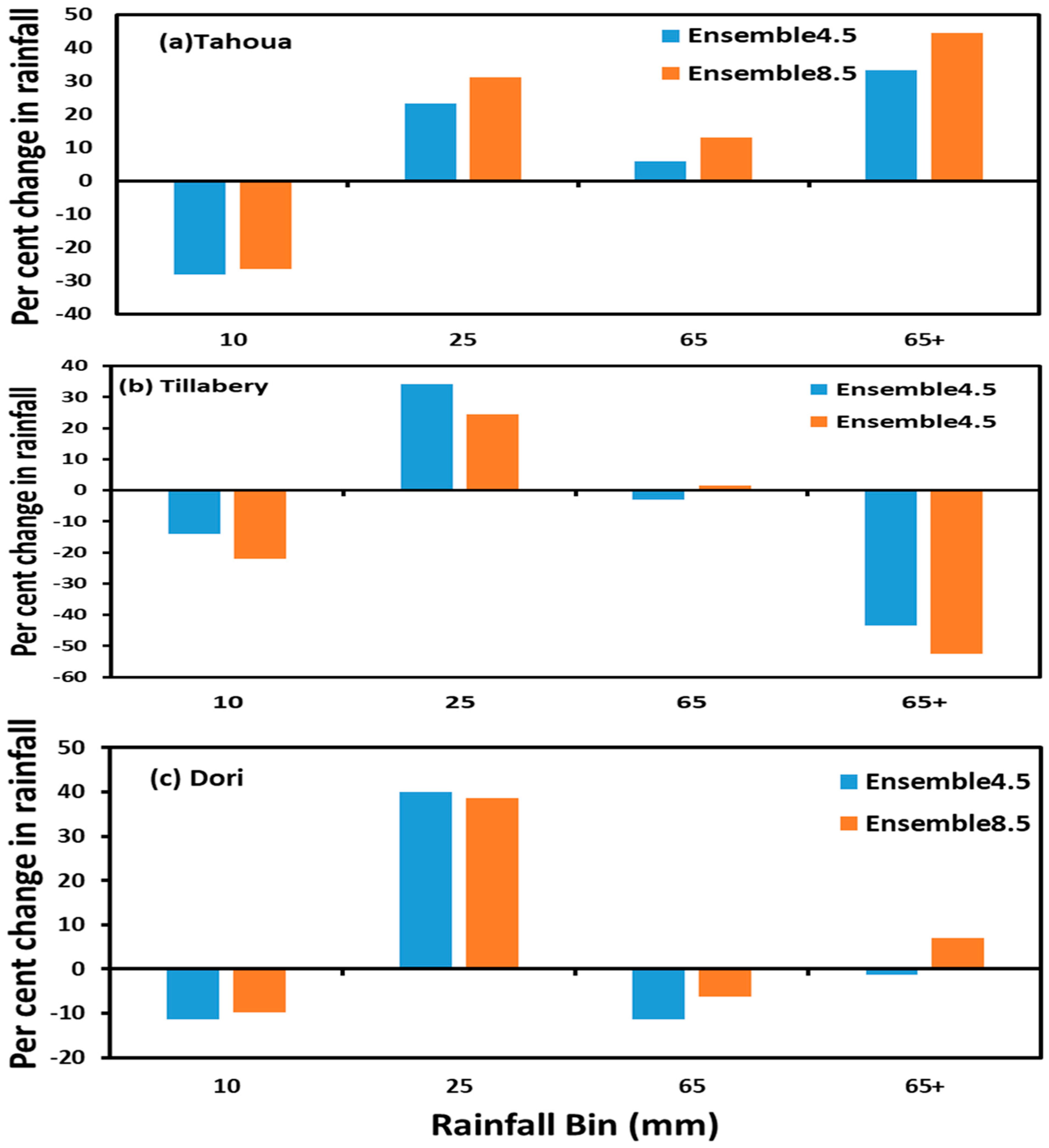
3.2.2. Projected Change in Intensity and Frequency of Average Daily Rainfall Events in the Niger River Basin
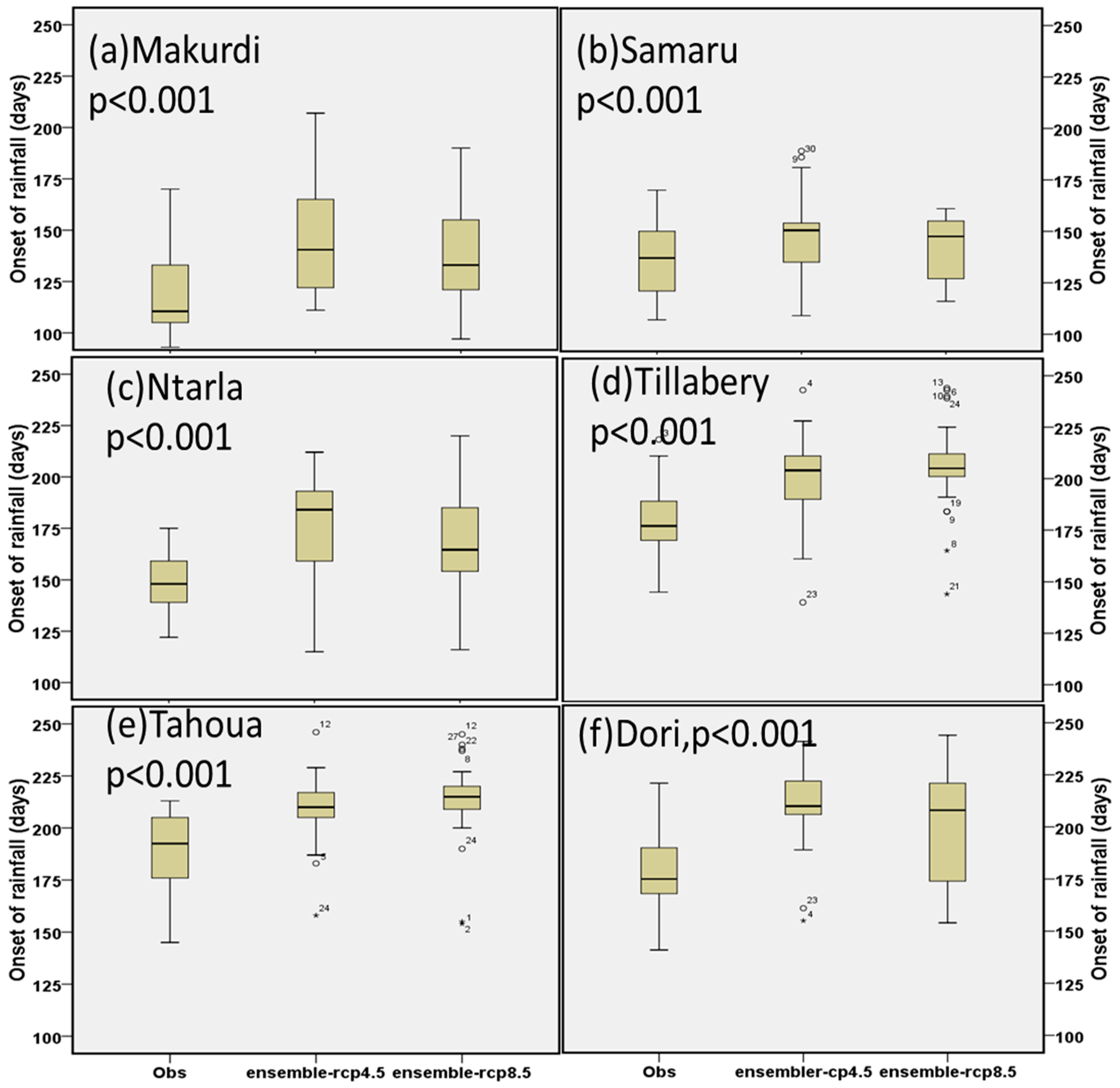
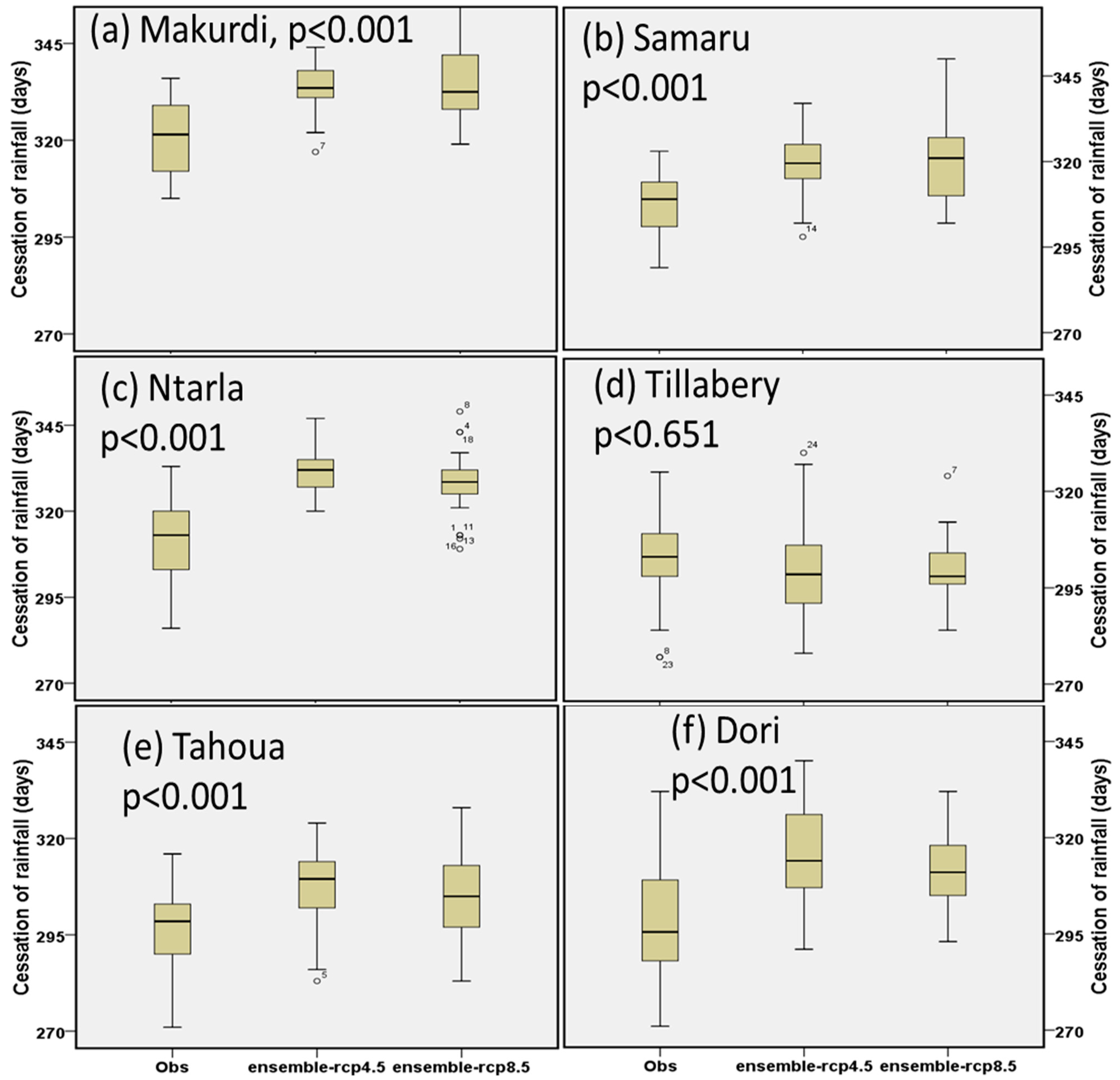
3.3. Onset/Cessation and Duration of the Rainy Seasons in the Niger River Basin
4. Conclusions
- For the locations analyzed for this study, the multi-model ensemble means of projected within season rainfall characteristics, including total season rainfall, onset, cessation, duration and rainfall intensities are not statistically different from point scale or site-specific observational rainfall data. However, given significant variability in rainfall over space, as well as uncertainties in future projections, this result must be interpreted cautiously. To investigate future changes in rainfall variables for other locations using a similar approach, it may be necessary to establish or confirm the relationship between site-specific and projected precipitation specific to the study location.
- The major changes in future seasonal rainfall include: (i) an increase in mean rainfall of up to 27% in the Guinea zone and about 12% in the Sahelian locations. The result is in agreement with those based on regional models, which also project a larger amount of rainfall increase in the Guinea zone relative to the Sahel [26,39,40]. (ii) The onset of the rainy season will be delayed by between two and four weeks while the mean date of rainfall cessation will also be delayed but by a smaller amount (10–16 days). Thus, the entire rainy season will shift backwards i.e. later in the year. Because the amount of the delay in onset is twice as much as the shift in cessation, the duration of the rainy season will also shorten by about one week. While the absolute value of these changes is small, their potential impacts may be considerably larger due to the variability around these mean dates.
- The models project that low-intensity rainfall is likely to decrease by up to 30% while moderate intensity rainfall will increase by up to 40%. However, the results for higher rainfall intensities are mixed. There is an increase for heavy rainfall but a decrease for the extreme rainfall category at some locations. Future studies are needed to investigate the likely impacts of these changes on agricultural productivity and other rainfall-dependent activities.
Supplementary Materials
Author Contributions
Funding
Acknowledgments
Conflicts of Interest
References
- Tarhule, A.; Woo, M. Towards an interpretation of Historical droughts in Northern Nigeria. Clim. Chang. 1997, 37, 601–616. [Google Scholar] [CrossRef]
- Andersen, I.; Dione, O.; Jarosewich-Holder, M.; Olivry, J.C. The Niger River Basin: A Vision for Sustainable Management; World Bank: Washington, DC, USA, 2005. [Google Scholar]
- Wani, S.P.; Sreedevi, T.K.; Rockström, J.; Ramajrishma, Y. Rainfed Agriculture—Past trends and Future prospects. In Rainfed Agriculture: Unlocking the Potential; Comprehensive Assessment of Water Management in Agriculture Series; Wani, S.P., Rockström, J., Oweis, T., Eds.; CABI Publishing: London, UK, 2009; Volume 7, pp. 1–35. [Google Scholar]
- World Bank. World Development Report 2008: Agriculture for Development; World Bank: Washington, DC, USA, 2007; pp. 1–365. [Google Scholar]
- Tarhule, A.; Saley-Bana, Z.; Lamb, P.J. Rainwatch: A Prototype GIS for Rainfall Monitoring in West Africa. Bull. Am. Meteorol. Soc. 2009, 11. [Google Scholar] [CrossRef]
- Blanc, E. The impact of climate change on crop yields in Sub-Saharan Africa. Am. J. Clim. Chang. 2012, 1. [Google Scholar] [CrossRef]
- Van Apeldorn, G.J. Perspectives on Droughts and Famine in Nigeria; George Allen and Uwin Ltd.: London, UK, 1981. [Google Scholar]
- Boyd, E.; Cornforth, R.J.; Lamb, P.J.; Tarhule, A.; Issa Lélé, M.; Brouder, A. Building resilience to face recurring environmental crisis in African Sahel. Nat. Clim. Chang. 2013, 3, 631–637. [Google Scholar] [CrossRef]
- Anyadike, R.N.C. Measures for containing the effects of drought on the environment. In Austerity and the Nigerian Society; Ofomata, G.E.K., Ikpeze, N.I., Eds.; UNN-Etukokwu Press: Onitsha, Nigeria, 1987; p. 367. [Google Scholar]
- Watts, M.J. Drought, environment and food security: Some reflections on peasants, pastoralists and commoditization in dryland West Africa. In Drought and Hunger in Africa; Glantz, M.H., Ed.; Cambridge University Press: Cambridge, UK, 1987. [Google Scholar]
- Watts, M.J. The agrarian crisis in Africa. Prog. Hum. Geogr. 1989, 13, 1–41. [Google Scholar] [CrossRef]
- U.S. Humanitarian Policy Studies. Disaster in the Desert: Failures of International Relief in the West African Drought; The Carnegie Endowment for International Peace: Washington, DC, USA, 1974; p. 66. [Google Scholar]
- Benson, C.; Clay, E.J. The impact of drought on sub-Saharan African Economies. IDS Bull. 1994, 25, 24–32. [Google Scholar] [CrossRef]
- Sylla, M.B.; Giorgi, F.; Coppola, E.; Mariotti, L. Uncertainties in daily rainfall over Africa: Assessment of gridded observation products and evaluation of a regional climate model simulation. Int. J. Climatol. 2013, 33, 1805–1817. [Google Scholar] [CrossRef]
- Klutse, N.A.B.; Sylla, M.B.; Diallo, I.; Sarr, A.; Dossio, A.; Diedhiou, A.; Kamga, A.; Lamptey, B.; Ali, A.; Gbobaniyi, E.O.; et al. Daily characteristics of West African summer monsoon precipitation in CORDEX simulations. Theor. Appl. Climatol. 2015. [Google Scholar] [CrossRef]
- Guan, K.; Sultan, B.; Biasutti, M.; Baron, C.; Lobell, D. What aspects of future rainfall changes matter for crop yields in West Africa? Geophy. Res. Lett. 2015, 42, 8001–8010. [Google Scholar] [CrossRef]
- Sultan, B.; Gaetani, M. Agriculture in West Africa in the twenty-first century: Climate change and impacts scenarios, and potential for adaptation. Front. Plant Sci. 2016, 7, 1262. [Google Scholar] [CrossRef]
- Afiesimama, E.A.; Pal, J.S.; Abiodun, B.J.; Gutowski, W.J., Jr.; Adedoyin, A. Simulation of West African monsoon using RegCM3. Part 1: Model validation and interannual variability. Theor. Appl. Climatol. 2006, 86, 23–27. [Google Scholar] [CrossRef]
- Sylla, M.B.; Gaye, A.T.; Pal, J.S.; Jenkins, G.S.; Bi, X. High resolution simulations of West Africa climate using regional climate model (RegCM3) with different lateral boundary conditions. Theor. Appl. Climatol. 2009, 98, 293–314. [Google Scholar] [CrossRef]
- Sylla, M.B.; Coppola, E.; Mariotti, L.; Giorgi, F.; Ruti, P.M.; Dell’Aquilla, A.; Bi, X. Multiyear simulation of the African climate using a regional climate model (RegCM3) with high resolution ERA-interim reanalysis. Clim. Dyn. 2010, 35, 231–247. [Google Scholar] [CrossRef]
- Nikulin, G.; Jones, C.; Giorgi, F.; Asrar, G.; Buchner, M.; Cerezo-Mota, R.; Christensen, O.B.; Deque, M.; Fernandez, J.; Hansler, A. Precipitation climatology in an ensemble of CORDEX-Africa Regional climate simulations. J. Clim. 2012, 25, 6057–6078. [Google Scholar] [CrossRef]
- Biasutti, M. Forced Sahel rainfall trends in the CMIP5 archive. J. Geophys. Res. Lett. 2013, 118, 1613–1623. [Google Scholar] [CrossRef]
- Sultan, P.; Roudier, P.; Quirion, P.; Alhassane, A.; Muller, B.; Dingkuhn, M.; Ciais, P.; Guimberteau, M.; Traore, S.; Baron, C. Assessing climate change impacts on sorghum and millet yields in the Sudanian and Sahelian savannas of West Africa. Environ. Res. Lett. 2013, 8, 1–9. [Google Scholar] [CrossRef]
- Gbobaniyi, E.; Sarr, A.; Sylla, M.B.; Diallo, I.; Lennard, C.; Dosio, A.; Dhiediou, A.; Kamga, A.; Klutse, N.A.B.; Hewitson, B.; et al. Climatology, annual cycle and interannual variability of precipitation and temperature in CORDEX simulations over West Africa. Int. J. Climatol. 2015, 34, 2241–2257. [Google Scholar] [CrossRef]
- Owosu, K.; Klutse, N.A.B. Simulation of the rainfall regime over Ghana from CORDEX. Int. J. Geosci. 2013, 4, 785–791. [Google Scholar] [CrossRef]
- Ibrahim, B.; Karambiri, H.; Polcher, J.; Yacouba, H.; Ribstein, P. Changes in rainfall regime over Burkina Faso under the climate change conditions simulated by 5 regional climate models. Clim. Dyn. 2014, 42, 1363–1381. [Google Scholar] [CrossRef]
- Mariotti, I.; Diallo, I.; Coppola, E.; Giorgi, F. Seasonal changes of African monsoon climates in 21st century CORDEX projections. Clim. Chang. 2014, 125, 53–65. [Google Scholar] [CrossRef]
- Biasutti, M.; Sobel, A.H. Delayed Sahel rainfall and global seasonal cycle in a warmer climate. Geophys. Res. Lett. 2009, 36, 23. [Google Scholar] [CrossRef]
- Seth, A.; Rauscher, S.A.; Rojas, M.; Giannini, A.; Camargo, S.J. Enhanced spring convective barrier for monsoons in a warmer world? Clim. Chang. 2011, 104, 403–414. [Google Scholar] [CrossRef]
- Taylor, K.E.; Stouffer, R.J.; Meehl, G.A. An overview of CMIP5 and the experiment design. Bull. Am. Meteorol. Soc. 2012, 93, 485–498. [Google Scholar] [CrossRef]
- Giannini, A.; Salack, S.; Lodoun, T.; Ali, A.; Gaye, A.; Ndiaye, O. A unifying view of climate change in the Sahel linking intra-seasonal, interannual and longer time scales. Environ. Res. Lett. 2013, 8, 024010. [Google Scholar] [CrossRef]
- Ibrahim, B.; Polcher, J.; Karambiri, H.; Rockel, B. Characterization of the rainy season in Burkina Faso and it’s representation by regional climate models. Clim. Dyn. 2012, 39, 1287–1302. [Google Scholar] [CrossRef]
- Obada, E.; Alamou, A.; Zandagba, E.; Biao, I.; Chabi, A.; Afouda, A. Comparative study of seven bias correction methods applied to three Regional Climate Models in Mekrou Catchment (Benin, West Africa). IJCET 2016, 6, 1831–1840. [Google Scholar]
- Monerie, P.A.; Fontaine, B.; Roucou, P. Expected future changes in the African monsoon between 2030 and 2070 using some CMIP3 and CMIP5 models under a medium-low RCP scenario. J. Geophys. Res. Atmos. 2012, 117, D16. [Google Scholar] [CrossRef]
- Monerie, P.A.; Roucou, P.; Fontaine, B. Mid-century effects of Climate Change on African monsoon dynamics using the A1B emission scenario. Int. J. Climatol. 2013, 33, 881–896. [Google Scholar] [CrossRef]
- Obada, E.; Alamou, E.; Zandagba, J.; Chabi, A.; Afouda, A. Change in future rainfall characteristics in the Mekrou Catchment (Benin), from an ensemble of 3 RCMs (MPI-REMO, DMI-HIRHAM5 and SMHI-RCA4). Hydrology 2017, 4, 14. [Google Scholar] [CrossRef]
- Sylla, M.B.; Giorgi, F.; Pal, J.S.; Gibba, P.; Kebe, I.; Nikiema, M. Projected changes in the annual cycle of high-intensity precipitation events over West Africa for the late twenty-first century. J. Clim. 2015, 28, 6475–6488. [Google Scholar] [CrossRef]
- Monerie, P.A.; Biasutti, M.; Roucou, P. On the projected increase of Sahel rainfall during the late rainy season. Int. J. Climatol. 2016, 36, 4373–4383. [Google Scholar] [CrossRef]
- Diallo, I.; Sylla, M.B.; Giorgi, F.; Gaye, A.T.; Camara, M. Multimodel GCM-RCM ensemble-based projections of temperature and precipitation over West Africa for the early 21st century. Int. J. Geophys. 2012, 2012, 1–19. [Google Scholar] [CrossRef]
- Sylla, M.B.; Nikiema, P.M.; Gibba, P.; Kebe, I.; Klutse, N.A.B. Climate change over West Africa: Recent trends and future projections. In Adaptation to Climate Change and Variability in Rural West Africa; Springer: New York, NY, USA, 2016; pp. 25–40. [Google Scholar]
- Schewe, J.; Levermann, A. Non-linear intensification of Sahel rainfall as a possible dynamic response to future warming. Earth Syst. Dyn. 2017, 8, 495–505. [Google Scholar] [CrossRef]
- Monerie, P.A.; Sanchez-Gomez, E.; Boé, J. On the range of future Sahel precipitation projections and the selection of a sub-sample of CMIP5 models for impact studies. Clim. Dyn. 2017, 48, 2751–2770. [Google Scholar] [CrossRef]
- Seth, A.; Rauscher, S.A.; Biasutti, M.; Giannini, A.; Camargo, S.J.; Rojas, M. CMIP5 projected changes in the annual cycle of precipitation in monsoon regions. J. Clim. 2013, 26, 7328–7351. [Google Scholar] [CrossRef]
- CORDEX-Africa. Available online: http://www.cordex.org/domains/region-5-africa/ (accessed on 12 December 2018).
- Hernandex-Diaz, L.; Laprise, R.; Sushama, L.; Martynov, A.; Winger, K.; Dugas, B. Climate simulation over the CORDEX-Africa domain using the fifth generation Canadian Regional Climate Model (CRCM5). Clim. Dyn. 2012, 40, 1415–1433. [Google Scholar] [CrossRef]
- Diallo, I.; Bain, C.L.; Giorgi, F.; Gaye, A.T.; Moufouma-Okia, W.; Niang, C.; Dieng, M.D.B.; Graham, R. Simulation of the West African monsoon onset using the HadGEM3-RA regional climate model. Clim. Dyn. 2014, 43, 575–594. [Google Scholar] [CrossRef]
- Akumaga, U.; Tarhule, A.; Piani, C.; Traore, B.; Yusuf, A.A. Utilizing Process-Based Modeling to Assess the Impact of Climate Change on Crop Yields and Adaptation Options in the Niger River Basin, West Africa. Agronomy 2018, 8, 11. [Google Scholar] [CrossRef]
- Haerter, J.O.; Eggert, B.; Moseley, C.; Piani, C.; Berg, P. Statistical precipitation bias correction of gridded model data using point measurements. Geophys. Res. Lett. 2015, 42, 1919–1929. [Google Scholar] [CrossRef]
- Piani, C.; Weedon, G.P.; Best, M.; Gomes, S.M.; Viterbo, P.; Hagemann, S.; Haerter, J.O. Statistical bias correction of global simulated daily precipitation and temperature for the application of hydrological models. J. Hydrol. 2010, 395, 199–215. [Google Scholar] [CrossRef]
- Benoit, P. The start of the growing season in northern Nigeria. Agric. Meteorol. 1977, 18, 91–99. [Google Scholar] [CrossRef]
- Kowal, J.M.; Kassam, A.H. Agricultural Ecology of Savanna: A Study of West Africa; Clarendon Press: Oxford, UK, 1978. [Google Scholar]
- Stern, R.D.; Dennett, M.D.; Dale, I.C. Analyzing daily rainfall measurements to give agronomically useful results: Direct methods. Method Exp. Agric. 1982, 18, 223–236. [Google Scholar] [CrossRef]
- Sivakumar, M.V.K. Predicting rainy season potential from the onset of rains in Southern Sahelian and Sudanian climatic zones of West Africa. Agric. For. Meteorol. 1988, 42, 295–305. [Google Scholar] [CrossRef]
- Ati, O.F.; Stigter, C.J.; Oladipo, E.O. A comparison of methods to determine the onset of the growing season in Northern Nigeria. Int. J. Climatol. 2002, 22, 731–742. [Google Scholar] [CrossRef]
- Liebman, B.; Blade, I.; Kiladis, G.N.; Carvalho, L.M.; Senay, G.B.; Allured, D.; Leroux, S.; Funk, C. Seasonality of African precipitation from 1996 to 2009. J. Clim. 2012, 25, 4304–4322. [Google Scholar] [CrossRef]
- Dunning, C.M.; Black, E.C.L.; Allan, R.P. The onset and cessation of seasonal rainfall over Africa. AGU Atmos. 2016, 121, 11405–11424. [Google Scholar] [CrossRef]
- Olaniran, O.J. The distribution in space of rain-days of rainfall of different amounts in the tropics: Nigeria as a case study. Geoforum 1988, 19, 507–520. [Google Scholar] [CrossRef]
- IPCC. Climate Change 2014: Synthesis Report. Contribution of Working Groups I, II, III to the Fifth Assessment Report of the Intergovernmental Panel on Climate Change; Cambridge University Press: Cambridge, UK, 2014. [Google Scholar]


| Type of Change/Manifestation/Explanation | References | Domain of the Study | Time Period | Models Used | Relevant Findings | Causes of Change |
|---|---|---|---|---|---|---|
Scenario 1. Shift in season either earlier (black curve) or later (red curve), without change in the total amount of rainfall or length of the season. An overall season delay in both the start and end of the rainy season in the whole region. Shortening of the rainy season [16,22,26,27,28,29,31,36,37] but [38] observed a lengthening of the monsoon season in some locations. | [28] | Sahel | 2075–2099/1975–1999 | CMIP3 used, evaluation method not specified. | An overall delay in both the start and end of the rainy season in the whole region. Shortening of the rainy season. | Changes in sea surface temperatures (SST). A phase shift of the annual cycle is a near-global response to GHG forcing and the delay in Sahel rainfall is a manifestation of this response. |
| [29] | West Africa | 2070–2099/1970–1999 | 10 CMIP3 models for special emission scenarios (SRES) A2. Student’s t-test is used to evaluate the models | A delayed onset and reduced early rainfall. | Response to global greenhouse gases (GHG) forcings. | |
| [31] | Sahel | 1941–2008, 1960–2000 and 1950–2010 | 17 CMIP3 and 15 CMIP5 models, evaluation method not specified. | Delayed onset of monsoons | Changes in SST, oceanic influences (North Atlantic warming continues to out-pace the global tropical oceans) | |
| [22] | Sahel | 2006–2099/1900–2005 | 20 CMIP5 models, evaluation method not specified | Delay in the onset of rainfall. | Response to greenhouse gases emissions (increase in GHGs) and changes in SST | |
| [26] | Burkina Faso, WestAfrica | 2021–2050/1971–2000 | 5 regional models (CCLM, HadRM3P, RACMO, RCA, REMO), models evaluated | One week delay in the future onset of the rainy season. Also, delay in cessation. | Changes in SST, oceanic influences (North Atlantic warming continues to out-pace the global tropical oceans) | |
| [27] | Sahel and West Africa | 2070–2099/1976–2005 | CORDEX (HadGEM2-ES and MPI-ESM models). The models were evaluated | A forward shift in monsoon season (an overall delay in both the start and end of the rainy season in the whole region) | Changes in SST, oceanic influences | |
| [37] | West Africa | 2080–2099/1985–2004 | 3 CMIP5 Models (MPI-ESM-MR, HadGEM2-ES and GFDL-ESM2M). Models were evaluated | A delay of monsoon onset | Result of future greenhouse gases | |
| [16] | West Africa | 2061–2090/1961–1990 | 16 CMIP5 Models. No evaluation was mention | A delay in both the start and end of the rainy season in the whole region. Shortening of the rainy season. | Changes in SST, oceanic influences (North Atlantic warming continues to out-pace the global tropical oceans. | |
| [36] | Benin | 2011–2040, 2041–2070 and 2071–2100 relative to 1981–2010 | 3 CORDEX models (MPI-REMO, DMI-HIRAHAM5 and SMHI-RCA4). Models bias- corrected but not evaluated on the parameters investigated | Rainy season projected to start one week early for 2011–2040 and 2041–2070 period but a delay in onset for 2071–2100 period. Cessation will be earlier in all times. The length of the rainy season is both positive (longer) and negative (shorter). | Result of future emissions of greenhouse gases | |
| [38] | Sahel/West Africa | 2031–2070/1960–1999 | 13 CMIP5 models | The onset is delayed in this zone. Also, a delay in the monsoon withdrawal | Changes in SST | |
Scenario 2. Change in the magnitude of seasonal rainfall either more/increase (blue curve) or less/decrease (red curve) without change in the onset, cessation, or length of the rainy season. Increase: Increase in the annual rainfall in Burkina Faso and West Africa. Increase in annual rainfall for the period 2071–2100 for Benin [26,36,37,39,40,41]. An overall increase in rainfall intensity (0–15%) [16]. Decrease: Decrease in precipitation amount for the period 2011–2040 and 2041–2070 for Benin [36,37,39]. An overall decrease of rainfall frequency (-5%–20%) across the whole West Africa [16,37]. | Increase: | |||||
| [39] | West Africa | 2031–2050/1981–2000 | HadCM3, HadRM3P, RCA, ECHAM5, RegCM2, REMO. The models were evaluated | Increase in precipitation over the regions north of the Gulf of Guinea. | Changes in SST | |
| [26] | Burkina Faso, West Africa | 2021–2050/1971–2000 | 5 regional models (CCLM, HadRM3P, RACMO, RCA, REMO) and models evaluated. | Increase in mean rainfall | Changes in SST, oceanic influences (North Atlantic warming continues to out-pace the global tropical oceans) | |
| [37,40] | West Africa | 2080–2099/1985–20 | 3 CMIP5 Models (MPI-ESM-MR, HadGEM2-ES and GFDL-ESM2M). Models were evaluated. | Increase in rainfall except for the Western Sahel | Result of future greenhouse gases | |
| [36] | Benin | 2011–2040, 2041–2070 and 2071–2100 | 3 CORDEX models (MPI-REMO, DMI-HIRAHAM5 and SMHI-RCA4). Models were bias- corrected but not evaluated on the parameters investigated | Increase 0–12% precipitation for 2071–2100 | Result of future greenhouse gases emissions | |
| [41] | Sahel | 2070–2099/1900–1999 | 30 CMIP5.The models were evaluated; 7 satisfactorily reproduced past climate | Seven models project 40-300% rainfall increase in Central Sahel over the 21st century. Three models project an increase of over 100% in average rainfall for central and eastern Sahel | Projected changes linked to a combination of local (through radiative forcing changes) and a remote (through tropical SST impacts on atmospheric stability) forcing mechanism | |
| Decrease: | ||||||
| [39] | West Africa | 2031–2050/1981–2000 | HadCM3, HadRM3P, RCA, ECHAM5, RegCM2, REMO. The models were evaluated. | More than 25% decrease in rainfall for all models except RCA. | Changes in SST | |
| [37] | West Africa | 2080–2099/1985–20 | 3 CMIP5 Models (MPI-ESM-MR, HadGEM2-ES and GFDL-ESM2M). Models were evaluated | Over the Gulf of Guinea region rainfall intensity decreases during pre- and post-monsoon phases | Result of future greenhouse gases | |
| [36] | Benin | 2011–2040, 2041–2070 and 2071–2100 | 3 CORDEX models (MPI-REMO, DMI-HIRAHAM5 and SMHI-RCA4). Models were bias- corrected but not evaluated on the parameters investigated | Decrease of up to −6% for the period 2011–2040 and 2041–2070 | Result of future greenhouse gases emissions | |
| [16] | West Africa | 2061–2090/1961–1990 | 16 CMIP5 Models. Evaluation method not specified | A decrease of rainfall frequency (−5%–20%) across the whole West Africa | Changes in SST, oceanic influences (North Atlantic warming continues to out-pace the global tropical oceans | |
| [27] | West Africa | 2070–2099/1976–2005 | CORDEX (HadGEM2-ES and MPI-ESM models). The models were evaluated | Decrease in precipitation | Changes in SST and ocean influences | |
| [42] | Sahel | 2060–2099/1960–1999 | 40 CMIP5 Models. Models were evaluated | Decrease of rainfall over the Western Sahel | Changes in SST | |
| [37] | West Africa | 2080–2099/1985–20 | 3 CMIP5 Models (MPI-ESM-MR, HadGEM2-ES and GFDL-ESM2M). Models were evaluated | A decrease of rainfall frequency (−5%–20%) across the whole West Africa | Result of future greenhouse gases | |
Scenario 3. Change in the magnitude of seasonal rainfall due to later onset of season without change in cessation (green curve), earlier cessation without change in onset (blue curve), or late onset and earlier cessation (red curve). A delay in both the start and end of the rainy season in the whole region [16,22,26,28,36]. Other studies projected an earlier cessation [27,28,36,37,39,43]. There is late onset but no change in cessation in some models. For two models, the rainy season period seems to be delayed without any change in the season duration. Thus, the rainy period is not projected to change significantly in these two models despite significant increase in the annual rainfall amount [26,36]. | [28] | Sahel | 2075–2099/1975–1999 | CMIP3 used. Evaluation method not specified. | Delay in both the start and end of the rainy season in the whole region | Changes in Changes in SST and GHG forcings |
| [22] | Sahel | 2006–2099/1900–2005 | 20 CMIP5 models. Models were evaluated | Delay in both the start and end of the rainy season in the whole region | Result of future greenhouse gases emissions (increase in GHGs) and changes in SST | |
| [26] | Burkina Faso, West Africa | 2021–2050/1971–2000 | 5 regional models (CCLM, HadRM3P, RACMO, RCA, REMO). Models were evaluated | Delay in both the start and end of the rainy season in the whole region | Changes in SST, oceanic influences (North Atlantic warming | |
| [16] | West Africa | 2061–2090/1961–1990 | 16 CMIP5 Models. Evaluation method not specified | Delay in both the start and end of the rainy season in the whole region | Changes in SST, oceanic influences (North Atlantic | |
| [36] | Benin, West Africa | 2011–2040, 2041–2070 and 2071–2100 | 3 CORDEX models (MPI-REMO, DMI-HIRAHAM5 and SMHI-RCA4) | Delay in both the start and end of the rainy season in the whole region for 2071–2100 period | Result of future greenhouse gases emissions | |
| [28] | Sahel | 2075–2099/1975–1999 | CMIP3 used. Evaluation method not specified | Late onset and early cessation | Changes in Changes in SST and GHG forcings | |
| [39] | West Africa | 2031–2050/1981–2000 | HadCM3, HadRM3P, RCA, ECHAM5, RegCM2, REMO. Models were evaluated. | Late onset and early cessation | Changes in SST | |
| [43] | West Africa | 2070–2099/1970–1999 | 10 CMIP3 models for SRES A2. Student’s t-test is used to evaluate the models | Late onset and early cessation | Response to GHG forcings | |
| [27] | West Africa | 2070–2099/1976–2005 | CORDEX (HadGEM2-ES and MPI-ESM models). The models were evaluated | Late onset and early cessation | Changes in SST and ocean influences | |
| [37] | West Africa | 2080–2099/1985–20 | 3 CMIP5 Models (MPI-ESM-MR, HadGEM2-ES and GFDL-ESM2M). Models were evaluated. | Late onset and early cessation | Result of future greenhouse gases emissions | |
| [36] | Benin | 2011–2040, 2041–2070 and 2071–2100 | 3 CORDEX models (MPI-REMO, DMI-HIRAHAM5 and SMHI-RCA4). Models were- bias-corrected but not evaluated on the parameters investigated | Late onset and early cessation | Result of future greenhouse gases emissions | |
| [26] | Burkina Faso, West Africa | 2021–2050/1971–2000 | 5 regional models (CCLM, HadRM3P, RACMO, RCA, REMO). Models were evaluated | Late onset, no change in cessation. | Changes in SST, oceanic influences (North Atlantic warming continues to out-pace the global Tropical oceans) | |
| [36] | 2011–2040, 2041–2070 and 2071–2100 | 3 CORDEX models (MPI-REMO, DMI-HIRAHAM5 and SMHI-RCA4). Models were bias-corrected but not evaluated on the parameters investigated | Late onset but no change in cessation. | Result of future greenhouse gases emissions | ||
| Scenario 4 Change in the within season distribution of rainfall from historical (black curve) to a right skewed distribution (green curve) or a left skewed distribution (red curve).  The projected precipitation increase in the central-eastern Sahel is characterized by a robust increase of the rainfall amounts in September–October [22,38]. There is a redistribution of precipitation in monsoon regions. Early summer decreases and late summer increases in precipitation are evident in the African regions [43]. Detailed regional analyses of CMIP5 experiments indicate a redistribution of rainfall within the rainy season in West Africa [22,43]. Rainfall anomalies are predominantly negative at the beginning of the rainy season (May and June), but positive at its end (October), indicating a delay of the main rainy season [28,38]. | [22] | Sahel | 2006–2099/1900–2005 | 20 CMIP5 models. Models are evaluated | Increased rainfall amounts in September–October (an indication of left skewed seasonal rainfall over the Sahel). | Response to greenhouse gases emissions (increase in GHGs) and changes in SST |
| [38] | Sahel/West Africa | 2031–2070/1960–1999 | 13 CMIP5 models | Increased rainfall amounts in September–October (an indication of left skewed seasonal rainfall over the Sahel). | Changes in SST | |
| [43] | West Africa | 2070–2099/1970–1999 | 10 CMIP3 models for SRES A2. Student’s t-test is used to evaluate the models | Less rain at the start of the season but more rain at the end of the season (an indication of the right skewed seasonal rainfall) | ||
| Agro-Zone | Location | F-test for Variance | t-test for Difference of Means | ||||||||||||||
|---|---|---|---|---|---|---|---|---|---|---|---|---|---|---|---|---|---|
| Ann. | Onset | End | Dur. | Rainfall Intensity | Ann. | Onset | End. | Dur. | Rainfall Intensity | ||||||||
| Low | Mod. | Heavy | Ext. | Low | Mod. | Heavy | Ext. | ||||||||||
| Southern Guinea | Makurdi | 0.001 | 0.069 | 0.000 | 0.006 | 0.498 | 0.490 | 0.478 | 0.023 | 0.978 | 0.101 | 0.776 | 0.724 | 0.856 | 0.950 | 0.840 | 0.230 |
| Northern Guinea | Samaru | 0.001 | 0.005 | 0.031 | 0.049 | 0.485 | 0.473 | 0.496 | 0.158 | 0.597 | 0.839 | 0.060 | 0.672 | 0.851 | 0.889 | 0.918 | 0.745 |
| Sahel | Tahoua | 0.001 | 0.001 | 0.278 | 0.004 | 0.489 | 0.469 | 0.448 | 0.135 | 0.944 | 0.877 | 0.110 | 0.127 | 0.994 | 0.936 | 0.913 | 0.683 |
| Dori | 0.001 | 0.001 | 0.313 | 0.000 | 0.448 | 0.469 | 0.483 | 0.043 | 0.646 | 0.127 | 0.337 | 0.655 | 0.755 | 0.944 | 0.864 | 0.264 | |
| Agro-Ecological Zone | Location | Average Rainfall (mm) | Ensemble Change (%) | Period | |||
|---|---|---|---|---|---|---|---|
| Obs. | RCP4.5 | RCP8.5 | RCP4.5 | RCP8.5 | |||
| Southern Guinea | Makurdi | 1168 | 1219 | 1222 | 4.5 * | 4.4 * | 2025–2050 |
| Northern Guinea | Samaru | 983 | 1086 | 1134 | 10.5 | 15.4 | 2021–2050 |
| N’Tarla | 826 | 912 | 952 | 12.0 | 26.5 | 2025–2050 | |
| Sahelian Zone | Tillabery | 381 | 389 | 392 | 2.0 * | 2.8 * | 2025–2050 |
| Tahoua | 355 | 399 | 421 | 12.5 | 18.7 | 2021–2050 | |
| Dori | 455 | 501 | 513 | 10.3 | 12.9 | 2021–2050 | |
| Agro-Zone | Location | t-test for Difference of Means | |||||||
|---|---|---|---|---|---|---|---|---|---|
| Annual | Onset | End | Duration | Rainfall Intensity | |||||
| Low | Moderate | Heavy | Extreme | ||||||
| Southern Guinea | Makurdi | 0.258 | 0.001(+) | 0.001(+) | 0.0289(–) | 0.001(+) | 0.001(+) | 0.001(+) | 0.001(+) |
| Northern Guinea | Samaru | 0.004(+) | 0.048(+) | 0.001(+) | 0.744 | 0.001(+) | 0.002(+) | 0.001(+) | 0.013(+) |
| N’Tarla | 0.003(+) | 0.001(+) | 0.001(+) | 0.001(–) | 0.001(+) | 0.355 | 0.685 | 0.001(+) | |
| Sahel | Tahoua | 0.037(+) | 0.001(+) | 0.001(+) | 0.142 | 0.001(+) | 0.003(+) | 0.054(+) | 0.386 |
| Tillabery | 0.732 | 0.001(+) | 0.653 | 0.003(–) | 0.001(+) | 0.018(+) | 0.014(+) | 0.004(+) | |
| Dori | 0.051(+) | 0.001(+) | 0.001(+) | 0.006(–) | 0.001(+) | 0.039(+) | 0.036(+) | 0.041(+) | |
| Southern Guinea (Makurdi) | Mean Onset (days) | Change (%) | Mean Cessation (days) | Change (%) | Earliest Onset (days) | Earliest Cessation (days) | Latest Onset (days) | Latest Cessation |
| Obs. | 117 | 0 | 320 | 0 | 93 | 264 | 170 | 336 |
| Ensemble 4.5 | 147 | 26 | 334 | 4 | 111 | 317 | 207 | 361 |
| Ensemble 8.5 | 138 | 18 | 335 | 5 | 87 | 319 | 190 | 361 |
| Northern Guinea (Samaru) | Mean Onset (Julian days) | Change (%) | Mean cessation (Julian days) | Change (%) | Earliest onset (Julian days) | Earliest cessation (Julian days) | Latest onset (Julian days) | Latest cessation (Julian days) |
| Obs. | 136 | 0 | 307 | 0 | 107 | 289 | 170 | 323 |
| Ensemble 4.5 | 146 | 7 | 319 | 4 | 109 | 298 | 189 | 337 |
| Ensemble 8.5 | 143 | 6 | 320 | 4 | 116 | 302 | 161 | 350 |
| Sahel (Tahoua) | Mean Onset (Julian Days) | Change (%) | Mean Cessation (Julian Days) | Change (%) | Earliest Onset (Julian Days) | Earliest Cessation (Julian Days) | Latest onset (Julian Days) | Latest Cessation (Julian Days) |
| Obs. | 190 | 0 | 297 | 0 | 145 | 271 | 213 | 316 |
| Ensemble 4.5 | 209 | 10 | 307 | 4 | 158 | 283 | 246 | 324 |
| Ensemble 8.5 | 213 | 12 | 306 | 3 | 154 | 283 | 245 | 328 |
| Sahel (Dori) | Mean Onset (Julian days) | Change (%) | Mean cessation (Julian days) | Change (%) | Earliest onset (Julian days) | Earliest cessation (Julian days) | Latest onset (days) | Latest cessation (Julian days) |
| Obs. | 178 | 0 | 299 | 0 | 141 | 271 | 221 | 332 |
| Ensemble 4.5 | 210 | 19 | 315 | 6 | 155 | 291 | 241 | 340 |
| Ensemble 8.5 | 201 | 13 | 312 | 4 | 154 | 293 | 244 | 332 |
© 2018 by the authors. Licensee MDPI, Basel, Switzerland. This article is an open access article distributed under the terms and conditions of the Creative Commons Attribution (CC BY) license (http://creativecommons.org/licenses/by/4.0/).
Share and Cite
Akumaga, U.; Tarhule, A. Projected Changes in Intra-Season Rainfall Characteristics in the Niger River Basin, West Africa. Atmosphere 2018, 9, 497. https://doi.org/10.3390/atmos9120497
Akumaga U, Tarhule A. Projected Changes in Intra-Season Rainfall Characteristics in the Niger River Basin, West Africa. Atmosphere. 2018; 9(12):497. https://doi.org/10.3390/atmos9120497
Chicago/Turabian StyleAkumaga, Uvirkaa, and Aondover Tarhule. 2018. "Projected Changes in Intra-Season Rainfall Characteristics in the Niger River Basin, West Africa" Atmosphere 9, no. 12: 497. https://doi.org/10.3390/atmos9120497
APA StyleAkumaga, U., & Tarhule, A. (2018). Projected Changes in Intra-Season Rainfall Characteristics in the Niger River Basin, West Africa. Atmosphere, 9(12), 497. https://doi.org/10.3390/atmos9120497