Assessing the Correlation between Land Cover Conversion and Temporal Climate Change—A Pilot Study in Coastal Mediterranean City, Fethiye, Turkey
Abstract
1. Introduction
2. Study Area and Methodology
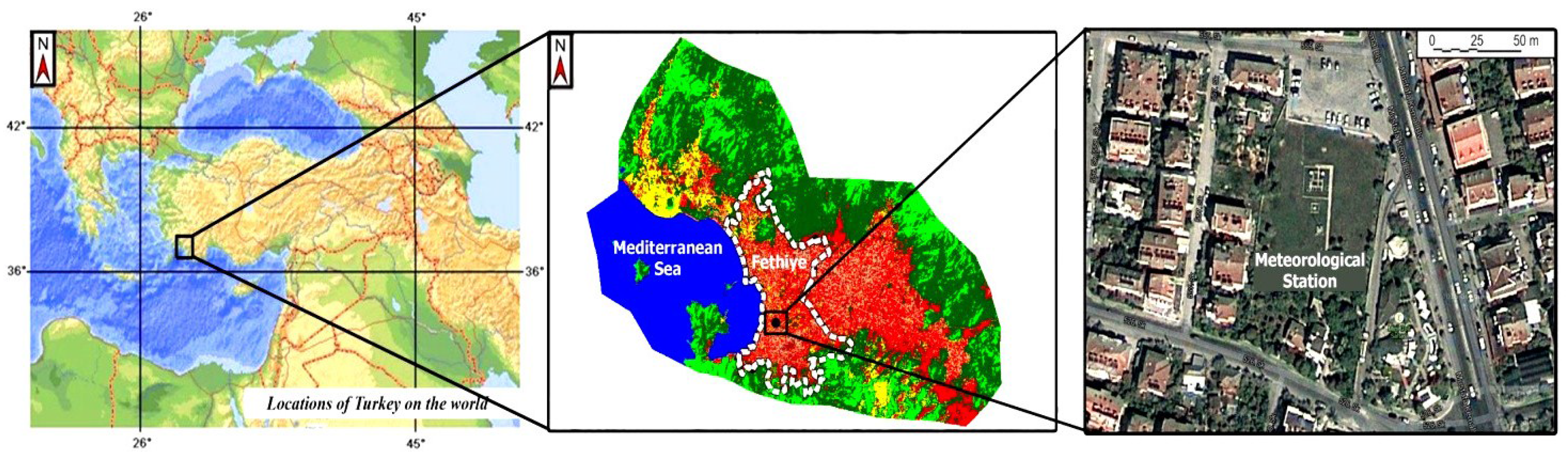
2.1. Study Area
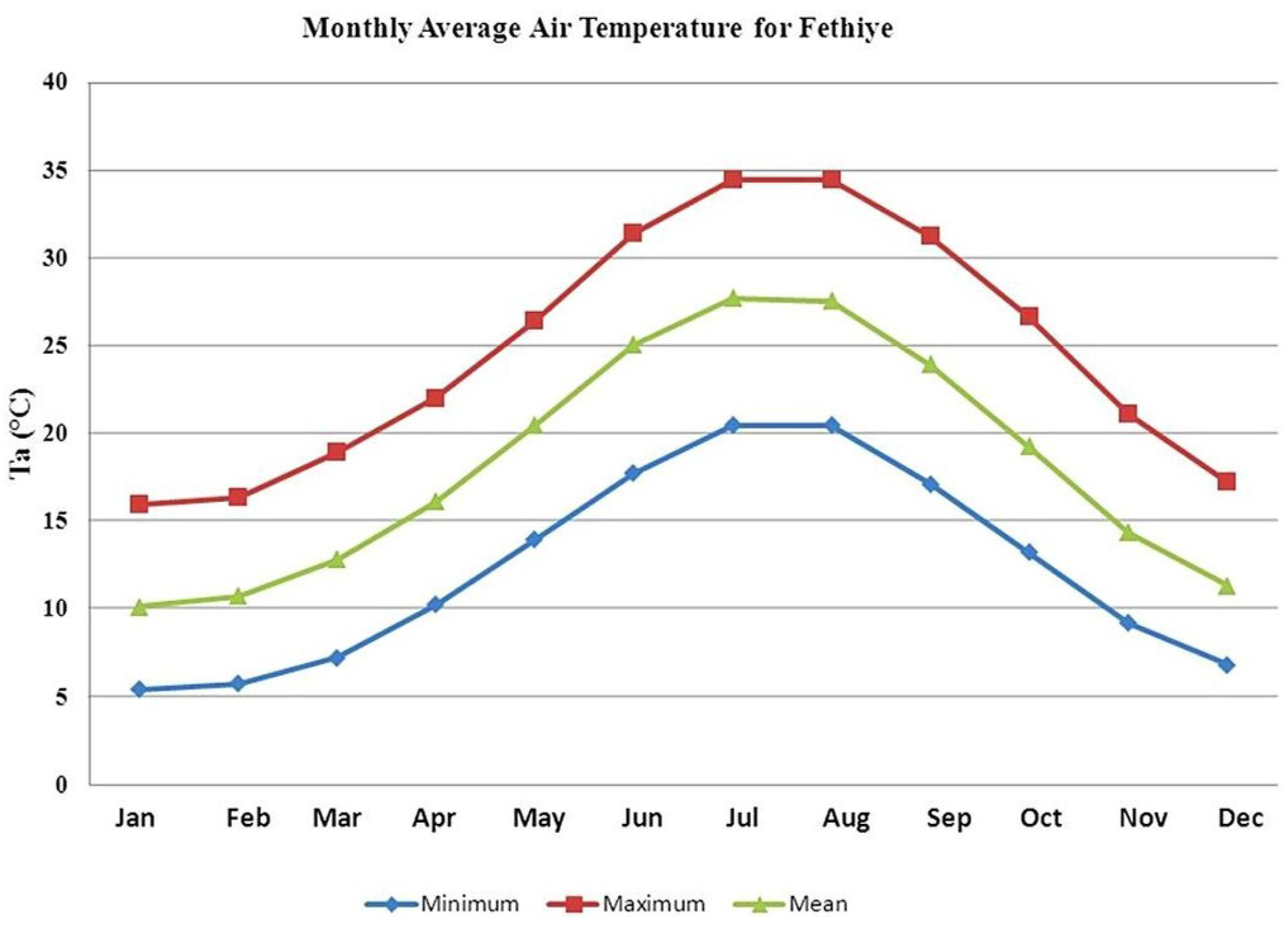
2.2. Data and Methodology
3. Results and Discussion
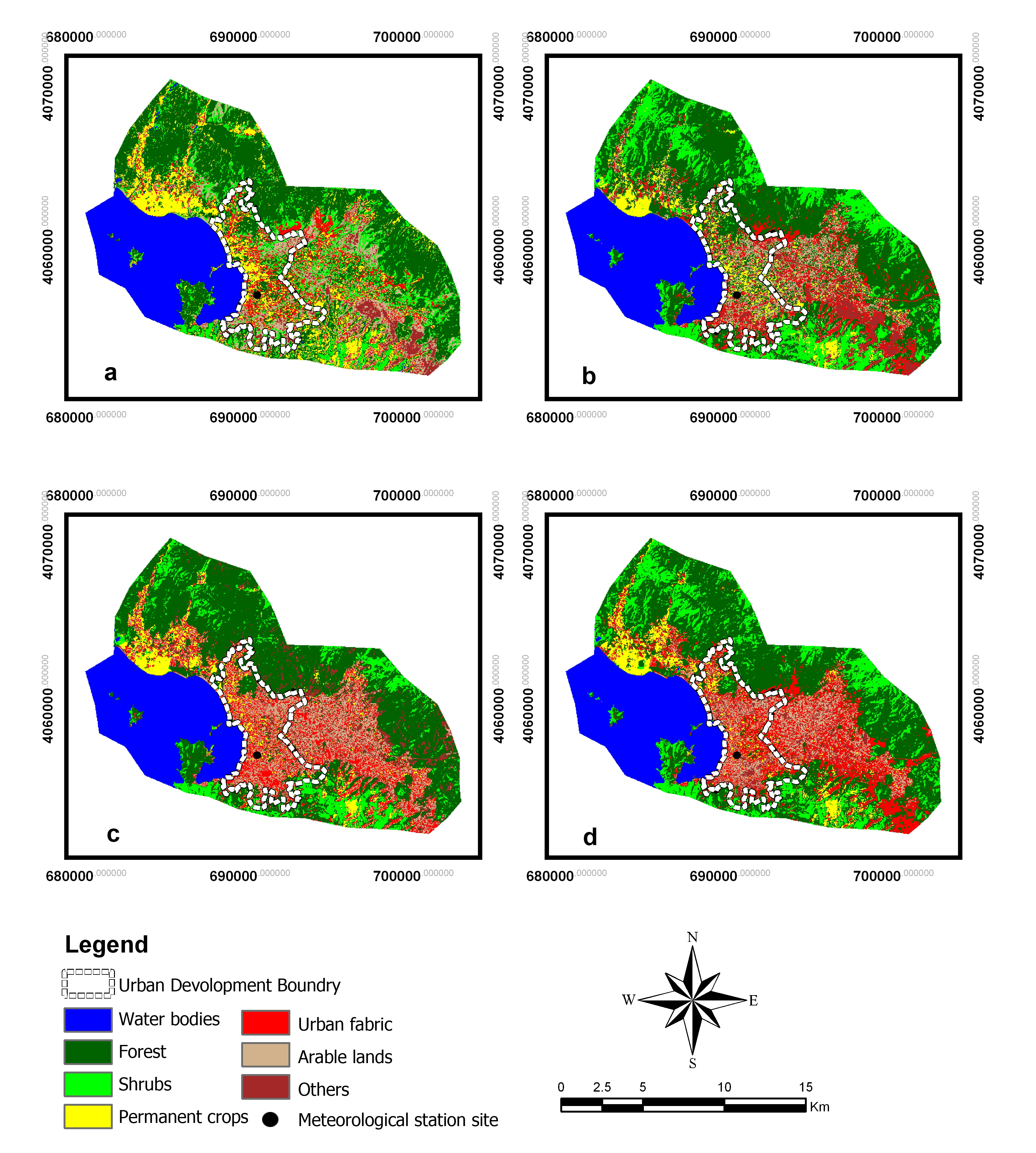
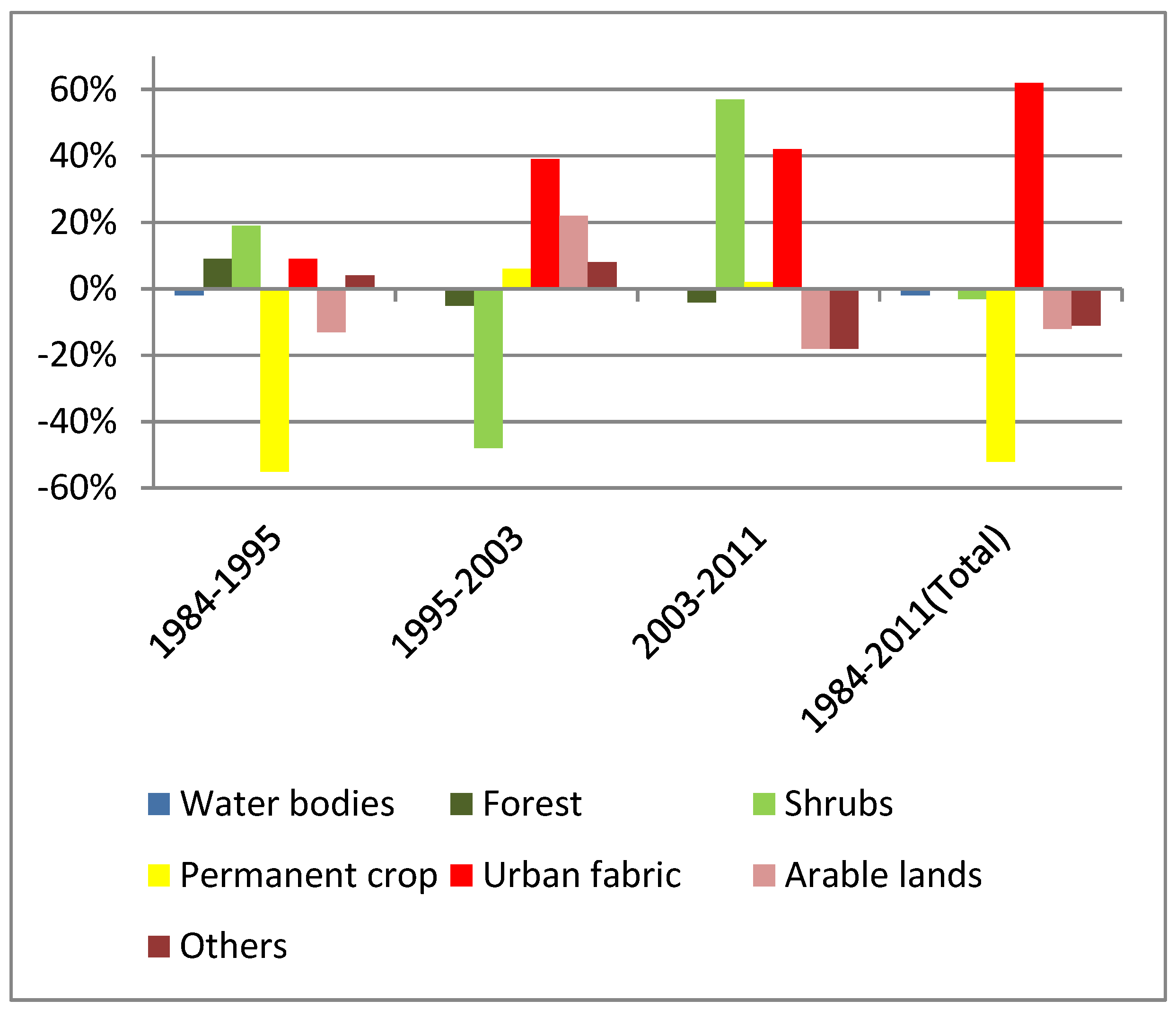
3.1. LULC Changes
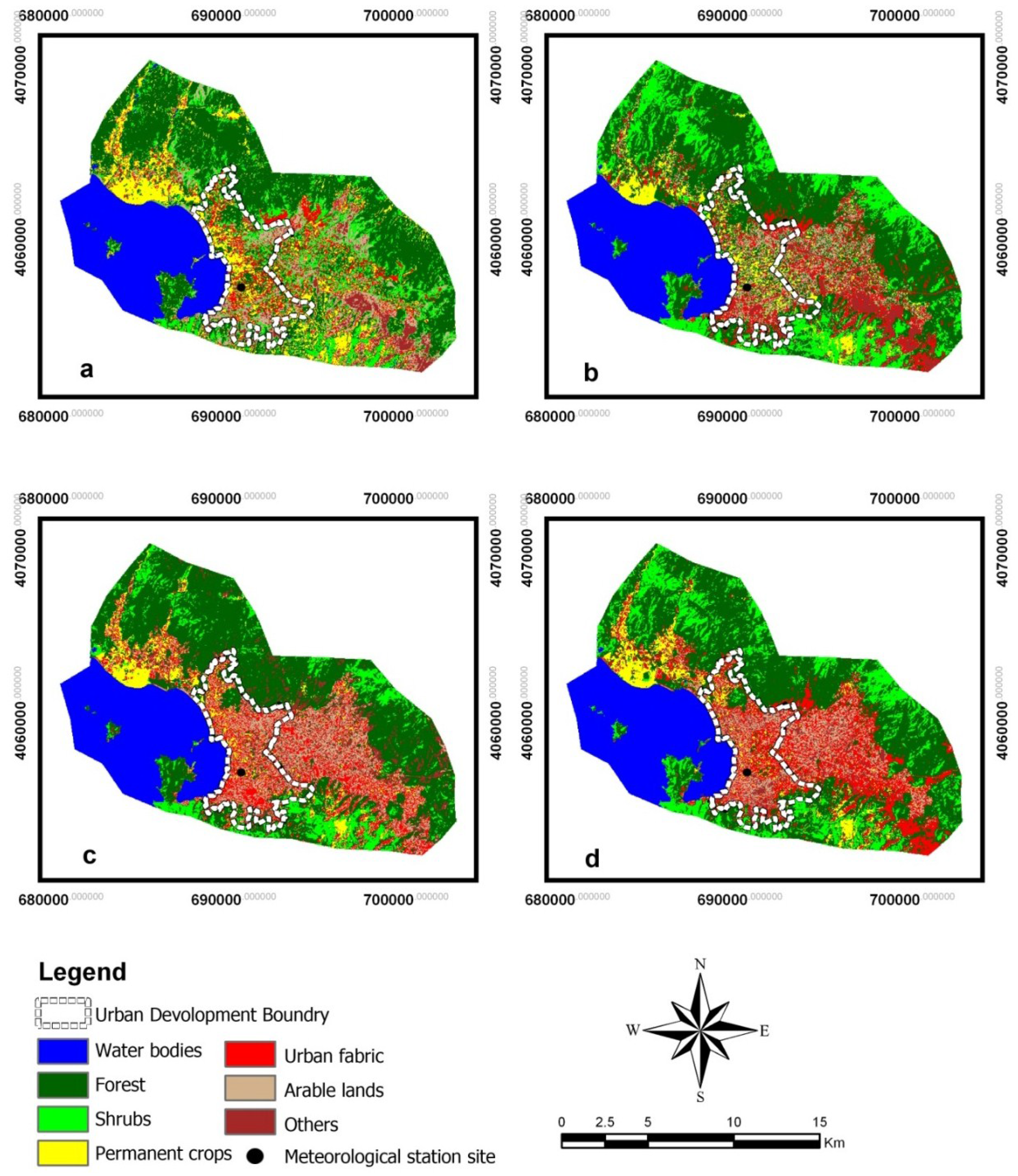

| CORINE Land Cover Index | LULC (ha) | |||||||
|---|---|---|---|---|---|---|---|---|
| 1984 | 1984–1995 Change | 1995 | 1995–2003 Change | 2003 | 2003–2011 Change | 2011 | 1984–2011 Total Change | |
| Water bodies | 4718 | −83 | 4635 | +16 | 4651 | −17 | 4634 | −84 |
| Forest | 9543 | +838 | 10381 | −468 | 9913 | −373 | 9540 | −3 |
| Shrubs | 3113 | +604 | 3717 | −1799 | 1918 | +1093 | 3011 | −102 |
| Permanent crop | 2638 | −1456 | 1182 | +73 | 1255 | +22 | 1277 | −1361 |
| Urban fabric | 2018 | +112 | 2130 | +806 | 2936 | +918 | 3854 | +1836 |
| Arable lands | 2120 | −265 | 1855 | +821 | 2676 | −820 | 1856 | −264 |
| Others | 913 | +250 | 1163 | +551 | 1714 | −823 | 891 | −90 |

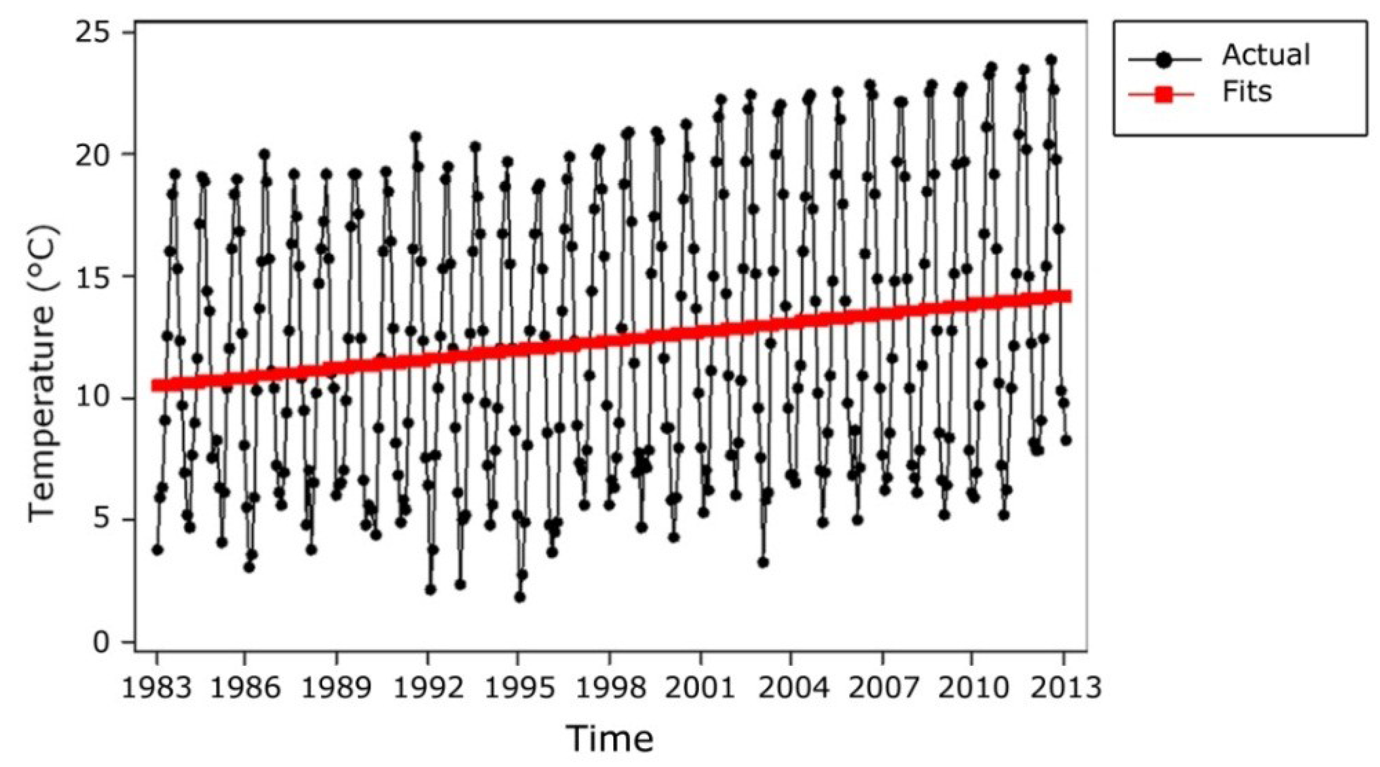
3.2. Trend Analysis of Decadal Air Temperature
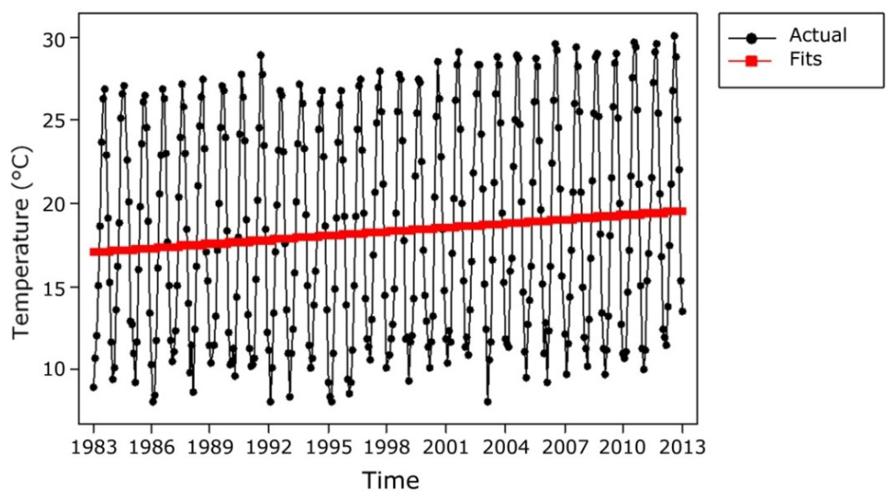
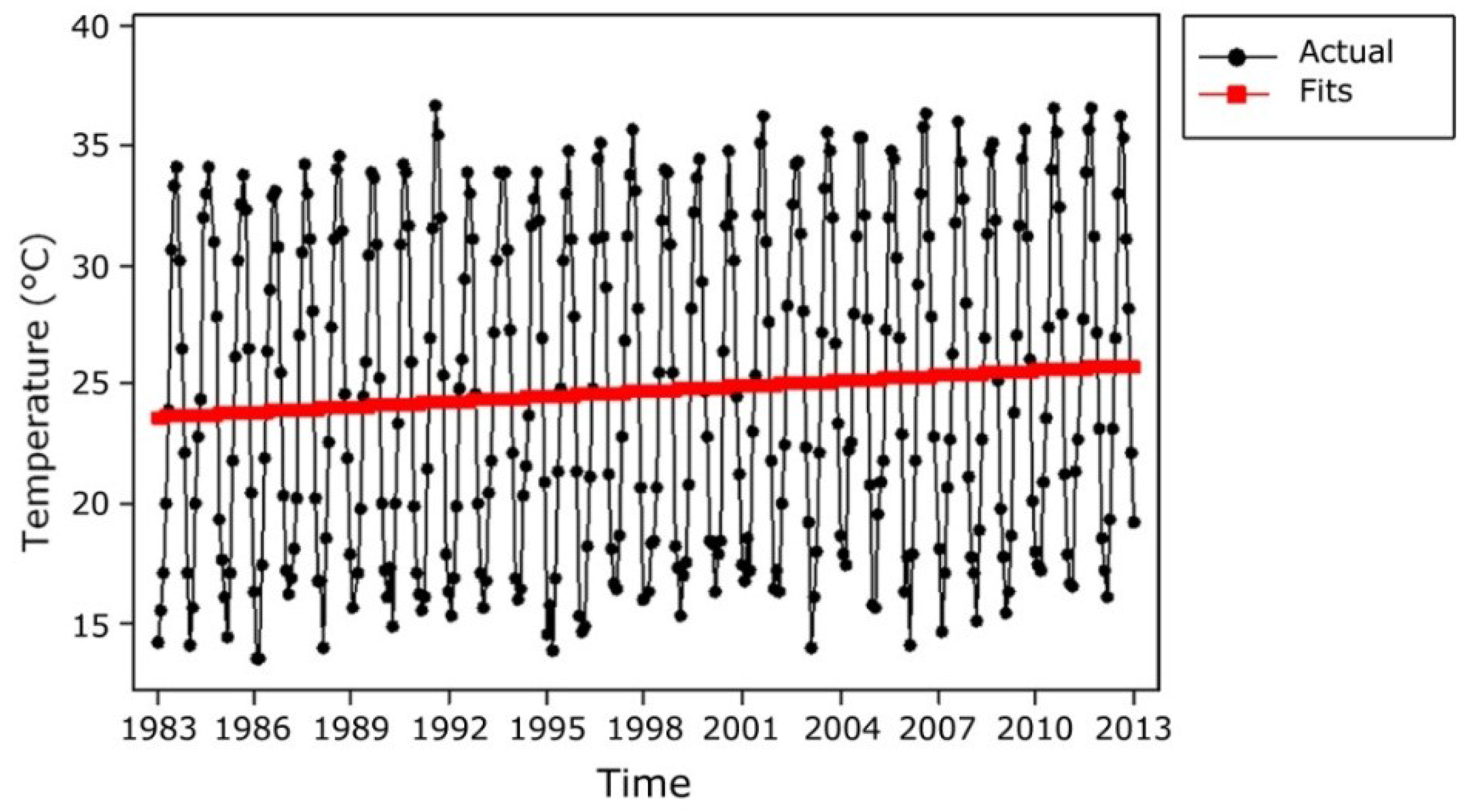
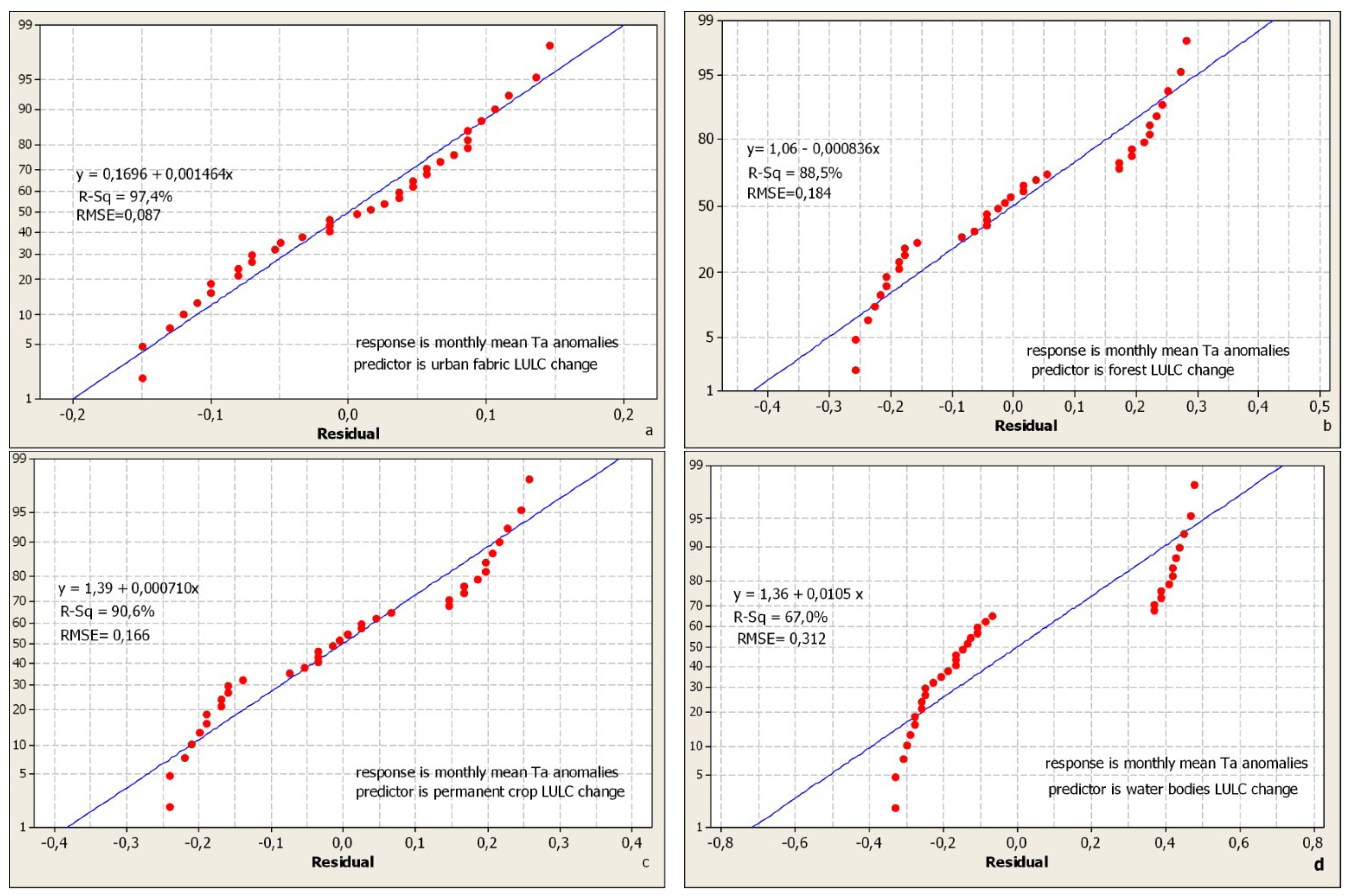
3.3. Regression Analysis of Air Temperature Anomalies and LULC Change Data
| Ta (°C) | Anomalies/Decades (°C) | ||
|---|---|---|---|
| 1983–1993 | 1993–2003 | 2003–2013 | |
| Monthly Mean Ta | 0.35 | 1.25 | 1.60 |
| Monthly Average of Maximum Ta | 0.46 | 0.90 | 1.36 |
| Monthly Average of Minimum Ta | 0.74 | 1.43 | 2.17 |
| CORİNE Land CoverDiversities | 1984–1995 Change | 1995–2003 Change | 2003–2011 Change | 1984-2011 Total Change |
|---|---|---|---|---|
| Water bodies | −83 | +16 | −17 | −84 |
| Forest | +838 | −468 | −373 | −3 |
| Shrubs | +604 | −1799 | +1093 | −102 |
| Permanent crop | −1456 | +73 | +22 | −1361 |
| Urban fabric | +112 | +806 | +918 | +1836 |
| Arable lands | −265 | +821 | −820 | −264 |
| Other | +250 | +551 | −823 | −90 |
| Months | Mean Ta (°C) Anomalies/Decades | ||
|---|---|---|---|
| 1983–1993 | 1993–2003 | 2003–2013 | |
| January | 0.40 | 1.30 | 1.66 |
| February | 0.38 | 1.28 | 1.60 |
| March | 0.34 | 1.27 | 1.57 |
| April | 0.32 | 1.22 | 1.55 |
| May | 0.32 | 1.20 | 1.55 |
| June | 0.28 | 1.20 | 1.57 |
| July | 0.30 | 1.24 | 1.60 |
| August | 0.32 | 1.23 | 1.59 |
| September | 0.35 | 1.25 | 1.61 |
| October | 0.36 | 1.25 | 1.62 |
| November | 0.38 | 1.27 | 1.63 |
| December | 0.42 | 1.28 | 1.65 |
4. Conclusions
Acknowledgments
Conflicts of Interest
References
- IPCC. Climate Change 2001: Impacts, Adaptation and Vulnarability; Contribution of Working Group II to the Third Assesment Report of the Intergovernmental Panel on Climate Change; McCarthy, J.J., Canziani, O.F., Leary, N.A., Dokken, D.J., White, K.S., Eds.; Cambridge University Press: Cambridge, UK, 2001. [Google Scholar]
- Mahmood, R.; Foster, A.; Logan, D. The GeoProfile metadata, exposure of instruments, and measurement bias in climatic record revisited. Int. J. Climatol. 2006, 26, 1091–1124. [Google Scholar] [CrossRef]
- Govindasamy, B.; Duffy, P.B.; Caldeira, K. Land use changes and northern hemisphere cooling. Geophys. Res. Lett. 2001, 28, 291–294. [Google Scholar] [CrossRef]
- Osborne, T.M.; Osborne, D.M.; Lawrence, J.M.; Slingo, A.J.; Challinor, T.R. Wheeler, Influence of vegetation on the local climate and hydrology in the tropics: Sensitivity to soil parameters. Clim. Dynm. 2004, 23, 45–61. [Google Scholar]
- Gibbard, S.; Caldeira, K.; Bala, G.; Phillips, T.J.; Wickett, M. Climate effects of global land cover change. Geophys. Res. Lett. 2005, 32, 705–714. [Google Scholar] [CrossRef]
- Alberti, M.; Marzluff, J. Ecological resilience in urban ecosystems: Linking urban patterns to ecological and human function. Urban Ecosyst. 2004, 7, 241–265. [Google Scholar] [CrossRef]
- Ackerman, B. Temporal march of the Chicago heat island. J. Clim. Appl. Meteorol. 1985, 24, 547–554. [Google Scholar] [CrossRef]
- Voogt, J.; Oke, T. Thermal remote sensing of urban climates. Remote Sens. Environ. 2003, 86, 370–384. [Google Scholar] [CrossRef]
- Song, C. Spectral mixture analysis for subpixel vegetation fractions in the urban environment: How to incorporate endmember variability? Remote Sens. Environ. 2005, 95, 248–263. [Google Scholar] [CrossRef]
- Masek, J.G.; Huang, C.; Wolfe, R.; Cohen, W.; Hall, F.; Kutler, J.; Nelson, P. North Amercan forest disturbance mapped from a decadal Landsat record. Remote Sens. Environ. 2008, 112, 2914–2926. [Google Scholar] [CrossRef]
- Su, W.; Zhang, Y.; Yang, Y.; Ye, G. Examining the impact of greenspace pattern on land surface temperature by coupling LİDAR DATA with a CFD Model. Sustainability 2014, 6, 6799–6814. [Google Scholar] [CrossRef]
- Stone, B. Land use as climate change mitigation. Environ. Sci. Technol. 2008, 43, 9052–9056. [Google Scholar] [CrossRef] [PubMed]
- Willems, E.; Vandevoort, C.; Willekens, A.; Buffaria, B. Landscape and land cover diversity index. Available online: http://ec.europa.eu/agriculture/publi/landscape (accessed on 15 May 2013).
- Gulinck, H.; Mugica, M.; Lucio, J.V.; Atauri, J.A. A framework for comparative landscape analysis and evaluation based on land cover data, with an application in the Madrid region (Spain). Landsc. Urban Plan. 2001, 55, 257–270. [Google Scholar] [CrossRef]
- Han, K.S.; Champeaux, J.L.; Roujean, J.L. A land cover classification product over France at 1 km resolution using SPOT4/VEGETATION data. Remote Sens. Environ. 2004, 92, 52–66. [Google Scholar] [CrossRef]
- Vancutsem, C.; Ceccato, P.; Dinku, T.; Connor, S. Evaluation of MODIS land surface temperature data to estimate air temperaturein different ecosystems over Africa. Remote. Sens. Environ. 2010, 114, 449–465. [Google Scholar] [CrossRef]
- Carlson, T.N.; Arthur, S.T. The impact of land use-land cover changes due to urbanization on surface microclimate and hydrology: A satellite perspective. Glob. Planet. Chang. 2000, 25, 49–65. [Google Scholar] [CrossRef]
- Chen, X.L.; Zhao, H.M.; Li, P.X.; Yin, Z.Y. Remote sensing image-based analysis of the relationship between urban heat island and land use/cover changes. Remote. Sens. Environ 2006, 104, 133–146. [Google Scholar] [CrossRef]
- Xiao, H.L.; Weng, Q.H. The impact of land use and land cover changes on land surface temperature in a karst area of China. J. Environ. Manag. 2007, 85, 245–257. [Google Scholar]
- Weng, Q.H.; Lu, D.S.; Schubring, J. Estimation of land surface temperature-vegetation abundance relationship for urban heat island studies. Remote. Sens. Environ 2004, 89, 467–483. [Google Scholar]
- Klok, L.; Zwart, S.; Verhagen, H.; Mauri, E. The surface heat island of Rotterdam and its relationshipwith urban surface characteristics. Resour. Consery. Recycl. 2012, 64, 23–29. [Google Scholar] [CrossRef]
- Dong, S.; Yan, X.; Xiong, Z. Varying responses in mean surface air temperature from land use/cover change in different seasons over northern China. Acta Ecol. Sin. 2013, 33, 167–171. [Google Scholar] [CrossRef]
- Li, J.J.; Wang, X.R.; Wang, X.J.; Ma, W.C.; Zhang, H. Remote sensing evaluation of urban heat island and its spatial pattern of the Shanghai metropolitan area, China. Ecol. Complex. 2009, 6, 413–420. [Google Scholar] [CrossRef]
- Owen, T.W.; Carlson, T.N.; Gillies, R.R. An assessment of satellite remotely sensed land cover parameters in quantitatively describing the climatic effect of urbanization. Int. J. Remote Sens. 1998, 19, 1663–1681. [Google Scholar] [CrossRef]
- Araya, Y.H.; Cabral, P. Analysis and modeling of urban land cover changes in Setubal and Sesimbra, Portugal. Remote Sens. 2010, 2, 1549–1563. [Google Scholar] [CrossRef]
- Weng, Q. Thermal infrared remote sensing for urban climate and environmental studies: Methods, applications and trends. ISPRS J. Photogramm. Remote Sens. 2009, 64, 335–344. [Google Scholar] [CrossRef]
- Schwarz, N.; Schlink, U.; Franch, U.; Grobmann, K. Relationship of land surface and air temperatures and its implications for quantifying urban heat island indicators—An application for the city of Leipzig (Germany). J. Ecol. Indic. 2012, 18, 693–704. [Google Scholar] [CrossRef]
- Cheng, K.S.; Su, Y.F.; Kuo, F.T.; Hunh, W.C.; Chiang, J.L. Assesing the effect landcover changes on air temperature using remote sensing images—A pilot study on northern Taiwan. Landsc. Urban Plan. 2008, 85, 85–96. [Google Scholar] [CrossRef]
- Turkish Statistical Institute. Avaiable online: http://www.turkstat.gov.tr (accessed on 20 March 2013).
- Kruscal, W.H.; Wallis, W.A. Use of ranks in one-criterion variance analysis. J. Am. Stat. Assoc. 1952, 47, 583–621. [Google Scholar] [CrossRef]
- Altınsoy, H.; Öztürk, T.; Türkeş, M.; Kurnaz, M.L. Projections of Future Air Temperature and Precipitation Changes in the Mediterranean Basin by Using the Global Climate Model. In Proceedings of the National Geographical Congress with International Participitation (CD-R), İstanbul, Turkey, 7–10 September 2011. (In Turkish)
- Sen, B.; Topçu, S.; Türkeş, M.; Sen, B.; Warner, J. F Projecting climate change, drought conditions and crop productivity in Turkey. Clim. Res. 2012, 52, 175–191. [Google Scholar] [CrossRef]
- Türkeş, M. Global Warming and Kyoto Protocol: Scientific, Economical, and Political Analysis of Climate Changes; Bağlam Publishing: İstanbul, Turkey, 2011; pp. 21–57. [Google Scholar]
- Türkeş, M. Physical Science Basis of the Climate Change: Physical Climate System, Enhanced Greenhouse Effect, Observed and Projected Climate Variations. In 5th Atmospheric Science Symposium Proceedings Book; Istanbul Technical University: Istanbul, Turkey, 2011; pp. 135–151. [Google Scholar]
- İyigün, C.; Türkeş, M.; Batmaz, İ.; Yozgatlıgil, C.; Purutçuoğlu, V.; Koç, E.K.; Öztürk, M.Z. Clustering current climatic regions of Turkey by using a multivariate statistical method. Theor. Appl. Climatol. 2011, 114, 95–106. [Google Scholar] [CrossRef]
- Türkeş, M.; Sümer, U.M.; Demir, I. Re-evaluation of trends and changes in mean, maximum and minimum temperatures of Turkey for the period 1929–1999. Int. J. Climatol. 2002, 22, 947–977. [Google Scholar] [CrossRef]
- Türkeş, M.; Sümer, U.M. Spatial and temporal patterns of trends and variability in diurnal temperature ranges of Turkey. Theor. Appl. Climatol. 2004, 77, 195–227. [Google Scholar] [CrossRef]
- Feng, X.Y.; Luo, G.P.; Li, C.F.; Dai, L.; Lu, L. Dynamics of ecosystem service value caused by land use changes in Manas River of Xinjiang, China. Int. J. Environ. Res. 2012, 6, 499–508. [Google Scholar]
- Odindi, J.O.; Mahangara, P. Green spaces trends in the city of Port Elizabeth from 1990 to 2000 using remote sensing. Int. J. Environ. Res. 2012, 6, 653–662. [Google Scholar]
- Barati, A.A.; Asadi, A.; Kalantari, K.; Azadi, H.; Witlof, F. Agricultural land conversion in Northwest Iran. Int. J. Environ. Res. 2015, 9, 281–290. [Google Scholar]
- Saptoma, S.K.; Nakona, Y.; Yuge, K.; Haraguchi, T. Observation and simulation of thermal environment in a paddy field. Paddy Water Environ. 2004, 2, 73–82. [Google Scholar] [CrossRef]
- Tian, Y.; Yin, K.; Lu, D.; Hua, L.; Zhao, Q.; Wen, M. Examining Land Use and Land Cover spatiotemporal change and driving forces in Beijing from 1978 to 2010. Remote Sens. 2014, 6, 10593–10611. [Google Scholar] [CrossRef]
- Bernatzky, A. The contribution of trees and green spaces to a town climate. Energ. Buildings 1982, 5, 1–10. [Google Scholar] [CrossRef]
- Georgi, N.J.; Dimitriou, D. The contribution of urban gren spaces to the improvement of environment in cities: Case study of Chania, Greece. Build. Environ. 2010, 45, 1401–1414. [Google Scholar] [CrossRef]
- Chen, Y.; Wong, N.H. Thermal benefits of city parks. Energy Build. 2006, 38, 105–120. [Google Scholar]
- Zhang, X.; Zhong, T.; Feng, X.; Wang, K. Estimation of the relationship between forest patches urban land surface temperature with remote sensing. Int. J. Remote Sens. 2009, 30, 2105–2118. [Google Scholar] [CrossRef]
- Jenerette, G.D.; Harlan, S.L.; Stefanov, W.L.; Martin, C.A. Ecosystem services and urban heat riskspace moderation: Water, green spaces and social inequality in Phoenix, USA. Ecol. Appl. 2011, 21, 2637–2651. [Google Scholar] [CrossRef] [PubMed]
- Shashua-Bar, L.; Pearlmutter, D.; Erell, E. The influences of trees and grass on outdoor thermal comfort in a hot-arid climate enviroment. Int. J. Climatol. 2011, 31, 1498–1506. [Google Scholar] [CrossRef]
© 2015 by the author; licensee MDPI, Basel, Switzerland. This article is an open access article distributed under the terms and conditions of the Creative Commons Attribution license (http://creativecommons.org/licenses/by/4.0/).
Share and Cite
Cinar, İ. Assessing the Correlation between Land Cover Conversion and Temporal Climate Change—A Pilot Study in Coastal Mediterranean City, Fethiye, Turkey. Atmosphere 2015, 6, 1102-1118. https://doi.org/10.3390/atmos6081102
Cinar İ. Assessing the Correlation between Land Cover Conversion and Temporal Climate Change—A Pilot Study in Coastal Mediterranean City, Fethiye, Turkey. Atmosphere. 2015; 6(8):1102-1118. https://doi.org/10.3390/atmos6081102
Chicago/Turabian StyleCinar, İsmail. 2015. "Assessing the Correlation between Land Cover Conversion and Temporal Climate Change—A Pilot Study in Coastal Mediterranean City, Fethiye, Turkey" Atmosphere 6, no. 8: 1102-1118. https://doi.org/10.3390/atmos6081102
APA StyleCinar, İ. (2015). Assessing the Correlation between Land Cover Conversion and Temporal Climate Change—A Pilot Study in Coastal Mediterranean City, Fethiye, Turkey. Atmosphere, 6(8), 1102-1118. https://doi.org/10.3390/atmos6081102