1. Introduction
Drought is a hydrometeorological phenomenon that has significant economic, social, and environmental impacts and that occurs in all climates of the world regardless of international boundaries [
1,
2]. A 2021 World Meteorological Organization report noted that drought caused more than USD 250 billion in economic losses and the death of more than 650,000 people globally during the last 50 years [
3]. According to statistics from the Center for Research on the Epidemiology of Disasters (CRED), in 2022 there were 2601 deaths worldwide attributed to drought, 106.9 million people were affected, and drought caused USD 34.2 billion in economic losses [
4]. Drought is essentially an imbalance between water supply (precipitation) and water demand (in nature, evapotranspiration), but it is a very difficult phenomenon to define because it often develops slowly, operates on multiple time scales, is difficult to recognize until its impacts are apparent, and produces effects that often accumulate slowly over time and may linger for years after the event ends [
5,
6,
7]. Drought occurs on multiple time scales. It has been described as a “creeping” phenomenon [
5,
8,
9] and experiencing its effects, in the words of a New Mexico rancher, is “like being slowly strangled” [
10]. Some droughts can develop rapidly when lower-than-normal rates of precipitation are accompanied by abnormally high temperatures, high winds, high insolation, and low humidity; such droughts are referred to as “flash droughts” [
11,
12]. The climatological community has consequently defined drought in general terms such as a “prolonged absence or marked deficiency of precipitation”, a “deficiency of precipitation that results in water shortage for some activity or for some group”, or a “period of abnormally dry weather sufficiently prolonged for the lack of precipitation to cause a serious hydrological imbalance” [
13,
14] and identified five general types of drought: meteorological, agricultural, hydrological, socioeconomic, and ecological drought. Meteorological drought is associated with atmospheric conditions resulting in the absence of or a reduction in precipitation and can develop quickly and end abruptly. Agricultural drought is usually associated with a short-term dryness of the surface soil layers (root zone) that occurs at a critical time during the growing season; flash drought can be an important factor in the development of agricultural drought. Precipitation deficits over a prolonged period that affect the surface or subsurface water supply result in hydrological drought and are associated with reduced streamflow, groundwater, reservoir, and lake levels; a hydrological drought will persist long after a meteorological drought has ended [
5]. Agricultural impacts are more often associated with drought that occurs at short time scales, while hydrological impacts are more often associated with drought that occurs at longer time scales [
15,
16,
17]. Socioeconomic drought associates the supply and demand of some economic goods with elements of meteorological, hydrological, and agricultural drought. Ecological drought is a recently identified type of drought defined as an episodic deficit in water availability that drives ecosystems beyond thresholds of vulnerability, impacts ecosystem services, and triggers feedbacks in natural and/or human systems [
18].
Numerous drought indices and indicators (like the World Meteorological Organization [
19], we define indicators as variables or parameters used to describe drought conditions, while indices are typically computed numerical representations of drought severity assessed using climatic or hydrometeorological inputs that may include indicators) have been developed over the decades to quantify drought. Early drought indices were limited by the data that were readily available at the time, primarily precipitation, and were tailored to specific applications for specific regions or measured specific types of drought. In 1965, Wayne Palmer developed an index that was the first to address the total moisture status by integrating water supply (precipitation), water demand (evapotranspiration), and water storage (soil moisture) [
5,
20]. Drought indices and models became more sophisticated as technology improved, more data became available (including remotely sensed data), and computer processing capabilities advanced. Some were developed with the intent to be more universally applicable, but it has been determined that no single drought index can adequately detect all types of drought for all locations [
5,
15,
19,
21,
22,
23,
24]. A “convergence of evidence” approach for drought monitoring, in which all relevant drought indices and indicators are examined to determine the level of drought, was pioneered in the U.S. with the Drought Monitor to address this difficulty [
25]. In order for the convergence of evidence (i.e., Drought Monitor) approach to work, the relevancy of the drought indices and indicators to accurately depict drought in specific regions needs to be known. The World Meteorological Organization (WMO) has compiled a list of many drought indices and indicators used globally in the
Handbook of Drought Indicators and Indices [
19], but the Handbook only lists the indices and indicators—it provides no guidance on when and where it is appropriate to use them—and it is not an exhaustive list.
An index or indicator is only as good as its correlation with actual or potential drought impacts and its utility in supporting drought management decisions. Two ways of testing this are objective comparisons with quantitative impact metrics and qualitative assessment through extended use by diverse practitioners. Quantitative scientific analyses have been conducted [
15,
22,
23], and others are ongoing, to assess the applicability of drought indices. Meanwhile, the climatological community has been employing a “use-inspired science” philosophy in recent years that links climate tools and services to sector-specific users and requirements by engaging with users and stakeholders through various venues [
26,
27,
28,
29,
30,
31,
32,
33]. Users have been engaged at workshops and other meetings, such as the annual Drought Monitor Forums and workshops sponsored by the U.S. National Oceanic and Atmospheric Administration’s (NOAA) National Integrated Drought Information System (NIDIS), U.S. Department of Agriculture (USDA), and U.S. Department of the Interior’s (DOI) Geological Service (USGS) to address user needs, improve drought communication, and improve drought-monitoring tools and methods. These user-engagement activities have resulted in an improved regional understanding of drought in those climate zones that are densely populated and have a long history of economic activity. But for regions that have limited climate data and limited economic activity, such as polar regions and tropical islands, the understanding of drought is limited. In the last decade, work has been carried out to address these gaps. This work includes several workshops to improve the understanding of drought and identify drought-monitoring tools appropriate for use in polar and tropical climates and a comprehensive 2-year study run by the Commission for Environmental Cooperation (CEC) to assess which drought indices and indicators are appropriate to use across all the diverse climates of North America. (The CEC was established by Canada, Mexico, and the United States to implement the North American Agreement on Environmental Cooperation, the environmental side-accord to the North American Free Trade Agreement. Its mission is to facilitate effective cooperation and public participation to conserve, protect and enhance the North American environment in support of sustainable development for the benefit of present and future generations).
This review paper integrates and summarizes the results of these recent workshops and the CEC study and supplements it with published research that objectively analyzes the effectiveness of drought indices. Based on this integrated information, this paper serves as a toolbox by providing guidance on when and where in North America it is appropriate to use the drought indices and indicators listed in the WMO Handbook, as well as other indicators that were not listed in the Handbook and/or were developed since the release of the Handbook.
The paper is organized into the following sections.
Section 1 (this Introduction) discusses the background leading to this review.
Section 2 discusses user-engagement activities (
Supplementary Material section S-1 describes the meetings and workshops in more detail).
Section 3 of this paper discusses drought definitions.
Section 4 summarizes the user-engagement data on the usefulness of drought indices and indicators discussed by Köppen climate type (
Supplementary Material sections S-3 and S-4 discuss results from these meetings and workshops in more detail).
Section 5 consolidates the discussion of the indicator and index assessment results from user-engagement activities and the published literature, discusses important implications of the user-engagement process, identifies some priorities for future work on indicators, and presents some general recommendations. Details of the meetings, workshops, published research, and the Köppen climate classification system and tables of acronyms are provided as
sections S-1 to S-6 in the Supplementary Material.
3. The Definition of Drought
The climatological community has grappled with the subject of the definition of drought for decades [
44]. Very specific definitions have been proposed for specific applications in specific regions, where drought is quantitatively defined using specific criteria [
5,
45]. Efforts to develop a universal definition of drought result in broad definitions like those referenced above in the Introduction.
The definition of drought was a discussion topic at the CEC consultations held on 8 October and 13 October 2020. Several participants defined drought using specific criteria of specific indices, with the criteria and indices used varying by region and application. A broad definition was offered (“drought is insufficient water to meet the needs of some activity or group”), but the importance of drought impacts was also noted as well as regulatory actions triggered by drought.
The subject of drought impacts needs to be treated carefully. As noted during the CEC consultations, some might argue that if there are no drought impacts, then there is no drought. If this proposition is to be accepted, there are at least four issues that need to be addressed. The first is that comprehensive, long-term drought impact data are lacking. We cannot state with confidence that there are no impacts if a drought is occurring without these data and thus, in these instances, there is an unclear relationship with impacts. Groups such as the National Drought Mitigation Center (NDMC) and Community Collaborative Rain, Hail & Snow (CoCoRaHS) Network have citizen science activities (Drought Impact Reporter web page:
https://droughtreporter.unl.edu/map/) (Condition Monitoring Observations web page:
https://www.cocorahs.org/content.aspx?page=condition) (accessed on 31 October 2023) to collect drought impact data in efforts to address this data gap. The second is the fact that many drought impacts are notoriously hard to quantify. For example, impacts of drought on crops in a given year are difficult to isolate from impacts of temperature, insects, and other phenomena. The third centers around types of drought. For agricultural, socioeconomic, and ecological drought, respectively, crops can be damaged, economic activities can be affected, and elements of the ecosystem (natural vegetation, wildlife, etc.) can be harmed. Hydrologic droughts can reduce natural streamflow, lake levels, and groundwater; these are special drought impacts that can be observed with quantitative measurements and therefore can be used as indicators (or even indices if there is a sufficient record), so they can be both impacts and indicators. A more likely hydrological impact would be reduced water supply to a user group. Meteorological drought is measured more by the lack of precipitation than any impacts. The fourth issue concerns mitigation strategies that have been put in place to reduce or postpone the impacts of drought. An example of this is the reservoir system in the western U.S. The reservoir system in California, for example, enables the state to endure several years of drought with reduced impacts on urban and irrigated agricultural users. The fact that these users are experiencing adequate water supply during a time of severe meteorological and ecological drought does not mean there is no drought; it just means that the impacts of drought have been mitigated for some—not all—water users. But there are situations in which prolonged drought can overwhelm even these mitigation strategies—water supplies become inadequate over time due to very long-term drought (and, in the case of the Colorado River, overallocation of water supplies), the mitigation system no longer functions, and impacts are significantly amplified. Clearly, as will be seen in subsequent sections of this paper, drought can cause significant impacts. Therefore, impacts may be a sufficient condition for drought in some cases, but they are not a necessary condition.
In the absence of a single definition of drought suitable for all situations and locations, the assessments of indices and indicators in this paper should be interpreted as relative to whatever individual participants considered drought to be.
4. North American Users’ Assessment of Drought Indices and Indicators
North America has climates spanning the range from tropical to polar, arid to humid, and maritime to continental. Very few drought indices and indicators are likely to be effective across all climate zones.
Section 4.2 provides an overview of the CEC survey results, while
sections S-3 and S-4 in the Supplementary Material contain a detailed discussion of drought indices and indicators used in the various climate zones summarized from the CEC survey and various user-engagement meetings and workshops.
Section 5.3.1 provides an overview of the published objective research that assesses the effectiveness of drought indices by climate zone, with a more detailed discussion of the published research provided in
section S-5 in the Supplementary Material. An exploration of why the indices and indicators are or are not effective and how they are used is in
Section 5 (
Section 5.2 and
Section 5.3.2).
4.1. Köppen Climate Types
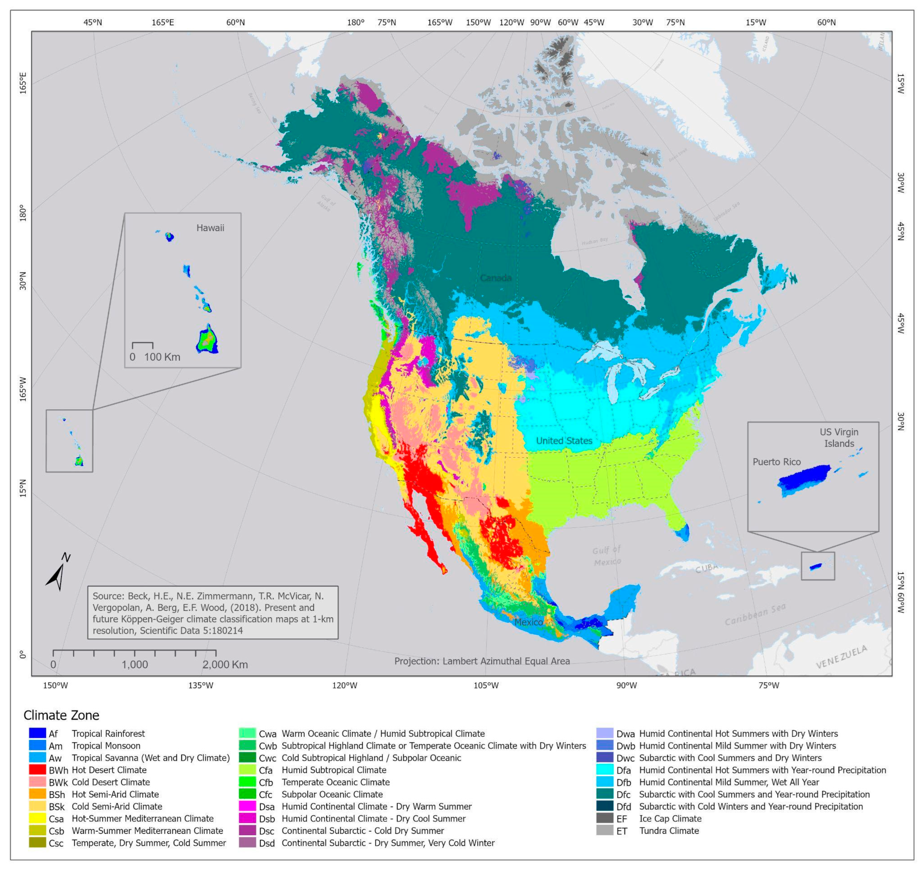
In the CEC survey, the Köppen climate classification was used to assess the drought indices and indicators because it is the most widely accepted global climate classification [
43]. Much of the published research referenced in this paper analyzed drought indices based on Köppen climate zones. Therefore, much of the discussion in this paper is broken down by Köppen climate type. Köppen was a Russian-born biologist who sought to relate vegetation types to climate. His classification scheme is based on monthly temperature, precipitation, and their seasonal characteristics [
46]. The major Köppen climate types are: A (Tropical climates that are hot year-round), B (Dry climates), C (Temperate climates—warm-temperature wet climates with mild winters), D (Continental climates with cold winters), and E (Polar climates).
The major climate types are indicated by the first letter of the climate zone codes shown in
Figure 1. The Köppen analysis and map were provided to the authors by Ricardo Llamas Barba through the Commission for Environmental Cooperation (CEC). The Köppen climate map was primarily derived from a pre-produced dataset published by Beck et al. [
47]. Ricardo Llamas Barba and his team made some adjustments, including resampling the pixel size and reprojecting the data to match the North American coordinate reference frame used by CEC. The North American climate zone map, along with the relevant metadata, is accessible through the CEC Environmental Atlas (
http://www.cec.org/north-american-environmental-atlas/) (accessed on 31 October 2023). In the CEC study and in this paper, Tropical climates include southern and coastal areas of Mexico, southern Florida, Puerto Rico and the U.S. Virgin Islands (USVI), the U.S. Affiliated Pacific Islands (USAPI), and coastal areas of Hawaii. Dry climates include parts of northern Mexico, much of the western U.S., and western portions of the Great Plains in the U.S. extending into parts of the southern Canadian Prairies. Temperate climates are located in parts of central Mexico, the west coasts of the U.S. and Canada, higher elevations in Hawaii, parts of the panhandle and southern coast of Alaska, and much of the southern Plains to the Southeast in the U.S. Continental climates are located in the U.S. from the central and northern Plains to the Northeast, across parts of the Northwest, and in much of Alaska; across most of Canada south of the Arctic Circle; and in areas of higher elevation. In North America, Polar (E) climates are located in northern parts of Alaska, the Canadian far north, and higher elevations in the western U.S. and western Canada.
4.2. CEC Survey Results
The CEC survey included questions about the overall geographical and seasonal performance of the drought indices and indicators, factors affecting the choice of indices and indicators used, and characteristics of drought, in addition to questions rating the effectiveness of the drought indicators and indices (see the CEC’s
Guide to Drought Indices and Indicators Used in North America for a list of the survey questions). It should be noted that, in the CEC survey, respondents were asked about drought, drought indices, and drought indicators as they pertained to their area of responsibility. The respondents also indicated which climate zones were included in their area of responsibility. In the discussion that follows, the responses were applied to all of the climate zones within the respondent’s area of responsibility. For some respondents, the geographical area of responsibility was small and included just one or a few climate zones; for others, the geographical area of responsibility was larger and may have included several climate zones. The presentation of the results in
Section 4 was carried out this way to make the results easier to digest, but this should be kept in mind when interpreting the percentages.
The CEC survey listed all possible Köppen climates and subzones. Some of the subzones are not present on the North American continent, yet survey respondents identified indices and indicators that they felt were (or would be) appropriate for monitoring drought in those subzones. Examples of such subzones include EF (glacial climates found only in Greenland and Antarctica), Dwd (found only in Siberia), and others. This may mean that those respondents have an interest in these subzones, so the survey results for these subzones were included in the discussion.
The sample size (number of respondents) varied among the climate types and especially among the climate subzones. The number of respondents for each of the subzones of each climate type can be found on the NCEI webpage (
https://www.ncei.noaa.gov/access/monitoring/nadiia/) (accessed on 31 October 2023). The number of respondents for each of the climate types is: A (49), B (133), C (116), D (138), and E (7) [
43]. The number of respondents for the A-D climate subzones ranged from four in subzones Cwc, Dsc, Dsd, and Dfd to thirty-seven in subzone BSk. For Polar climates, ET had five respondents and EF had two. (The reader is referred to the NCEI webpage (
https://www.ncei.noaa.gov/access/monitoring/nadiia/) for the full summary of survey responses for all climate subzones, indices and indicators, drought lengths, drought types, impacts, and factors affecting the choice of index. Only those identified as most important by the survey respondents are discussed in this manuscript.) With such a small respondent sample size, the survey answers may not be representative for EF climates. The discussion in this section will summarize responses by climate type and, in some cases, by climate subzone. For the climate type summaries, the responses were not simple averages of the subzone responses; they were weighted by the number of respondents in each of the subzones. The CEC study [
43] presented the results in data tables; the results are summarized in graphical form in this section for clarity of presentation and easier identification of geographical or climatological relationships.
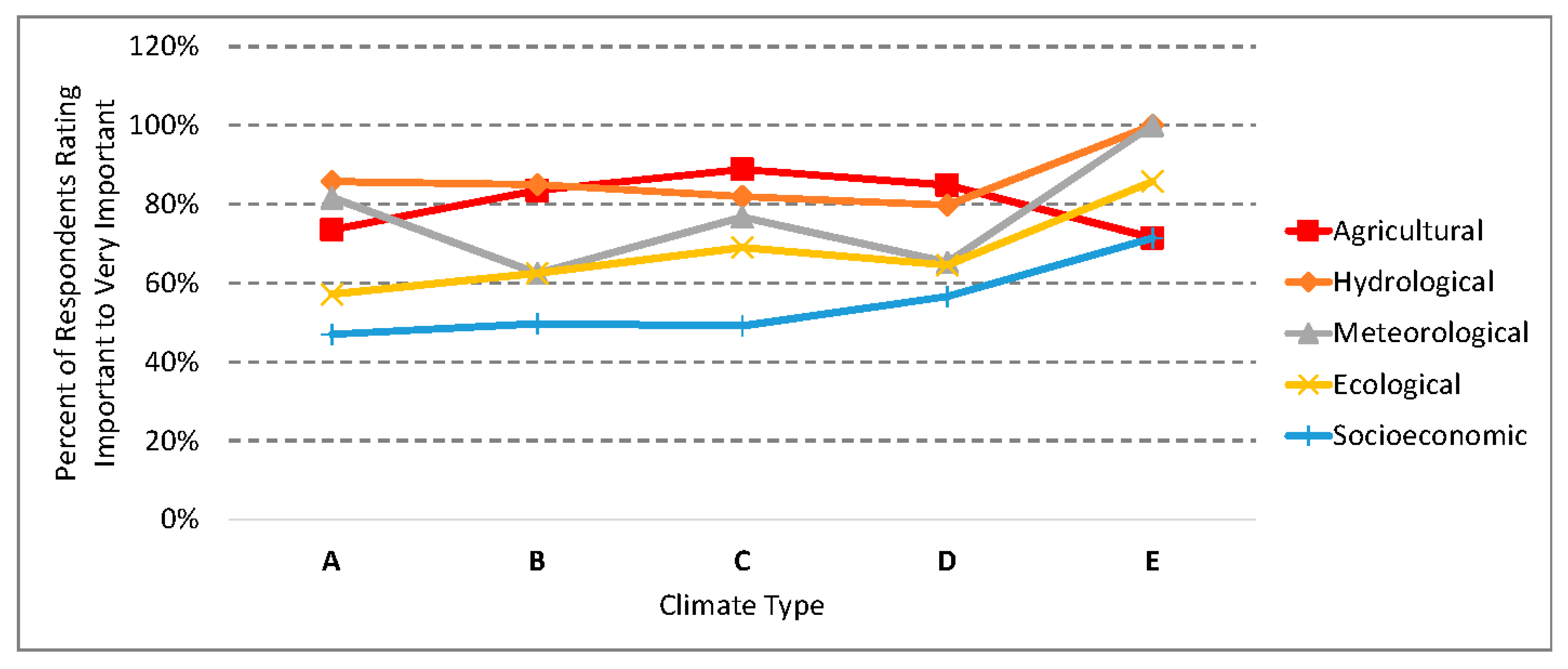
Drought type was rated on a scale of 1 (not important) to 5 (very important). Agricultural, hydrological, meteorological, and ecological droughts were rated as important to very important (ratings 4 or 5) by half or more of the respondents in all five climate types (
Figure 2). Socioeconomic drought was so rated by half or more of the respondents in D and E climates. The ratings were similar for the subzones, except for the following: socioeconomic drought was rated as important to very important by half or more of the respondents in the Af, Am, BSh, BWk, Cfb, Cfc, Csa, Csb, and Cwc subzones and socioeconomic drought was so rated by
less than half of the respondents in the Dfc subzone.
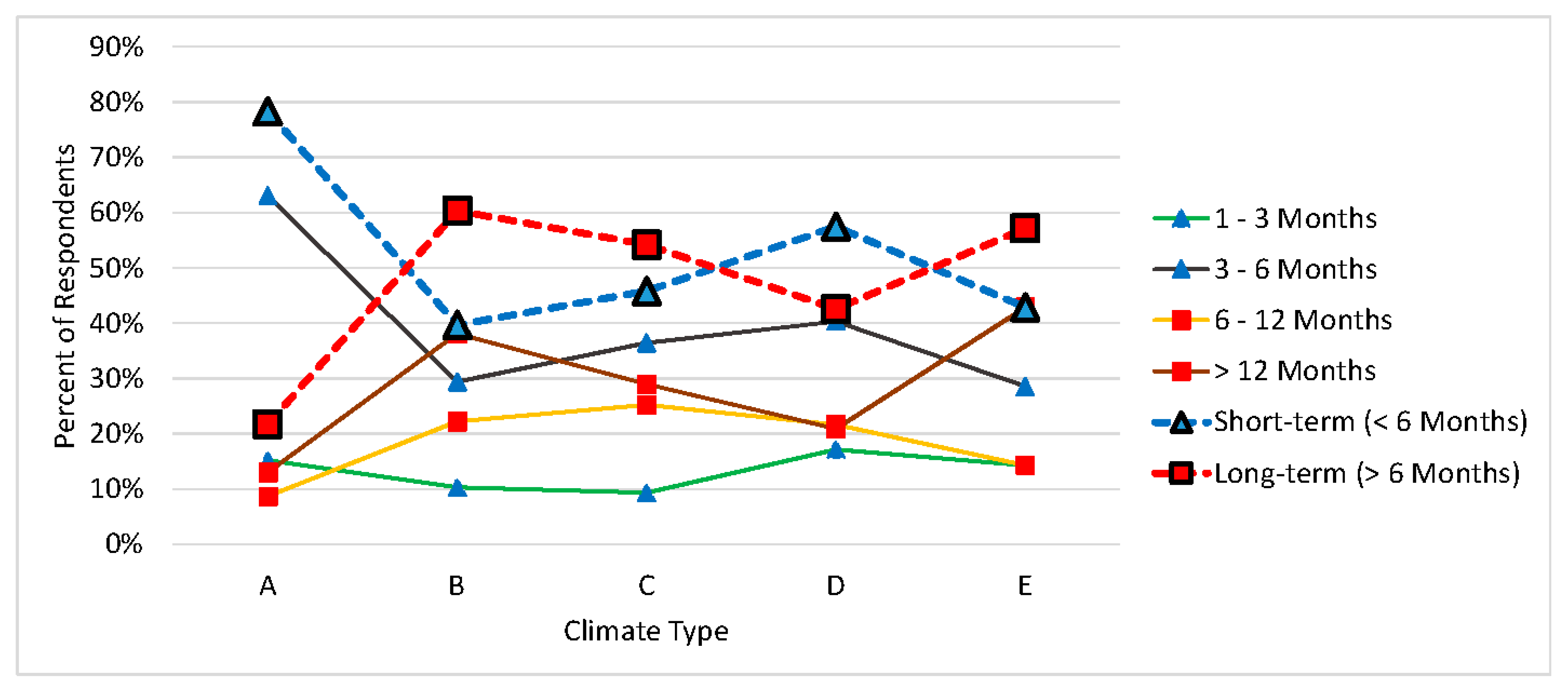
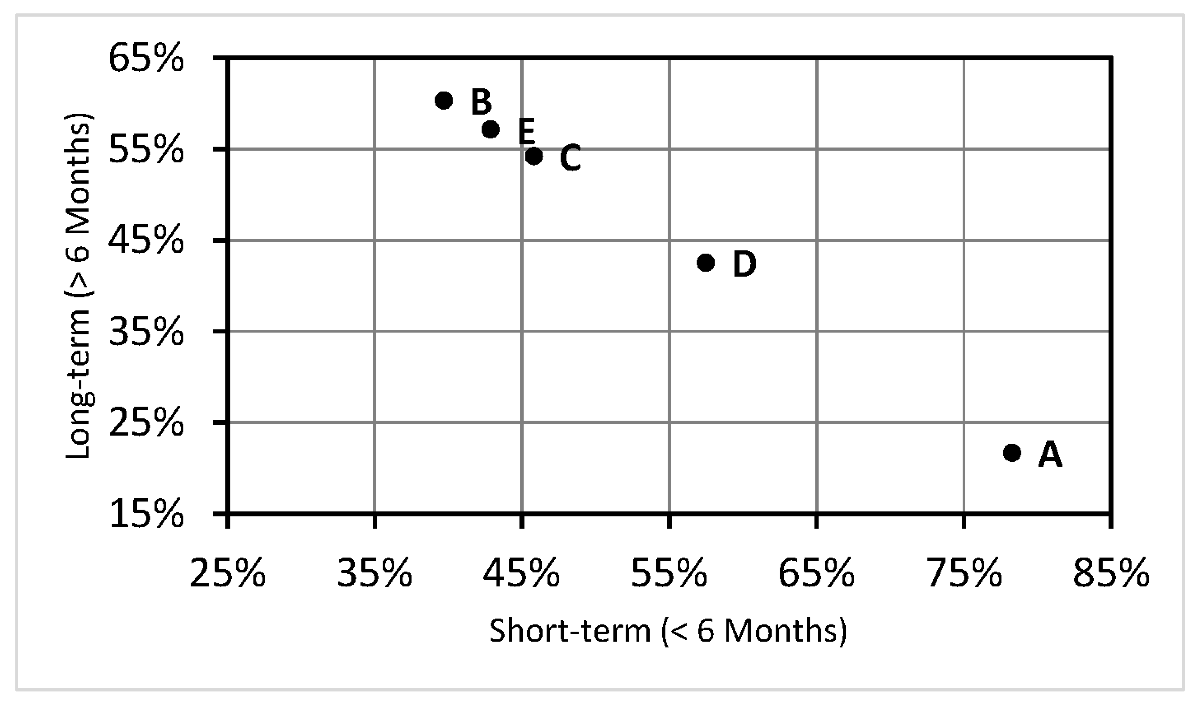
The duration of a typical drought was perceived by half or more of the respondents to be predominantly short-term (<6 months) in A and D climates and long-term (>6 months) in B, C, and E climates (
Figure 3 and
Figure 4), with nearly two-thirds of the respondents in A climates identifying 3–6 months as the typical length of droughts. The ratings varied by a wide margin in A climates and by narrower margins in B, C, D, and E climates. There were deviations from the climate type assessment at the subzone level, including: the majority of respondents perceived drought duration to be typically short-term instead of long-term in Cfa and Cwb subzones and the majority of respondents perceived drought duration to be typically long-term instead of short-term in the Dfc, Dsb, Dwa, Dwb, and Dwd subzones.
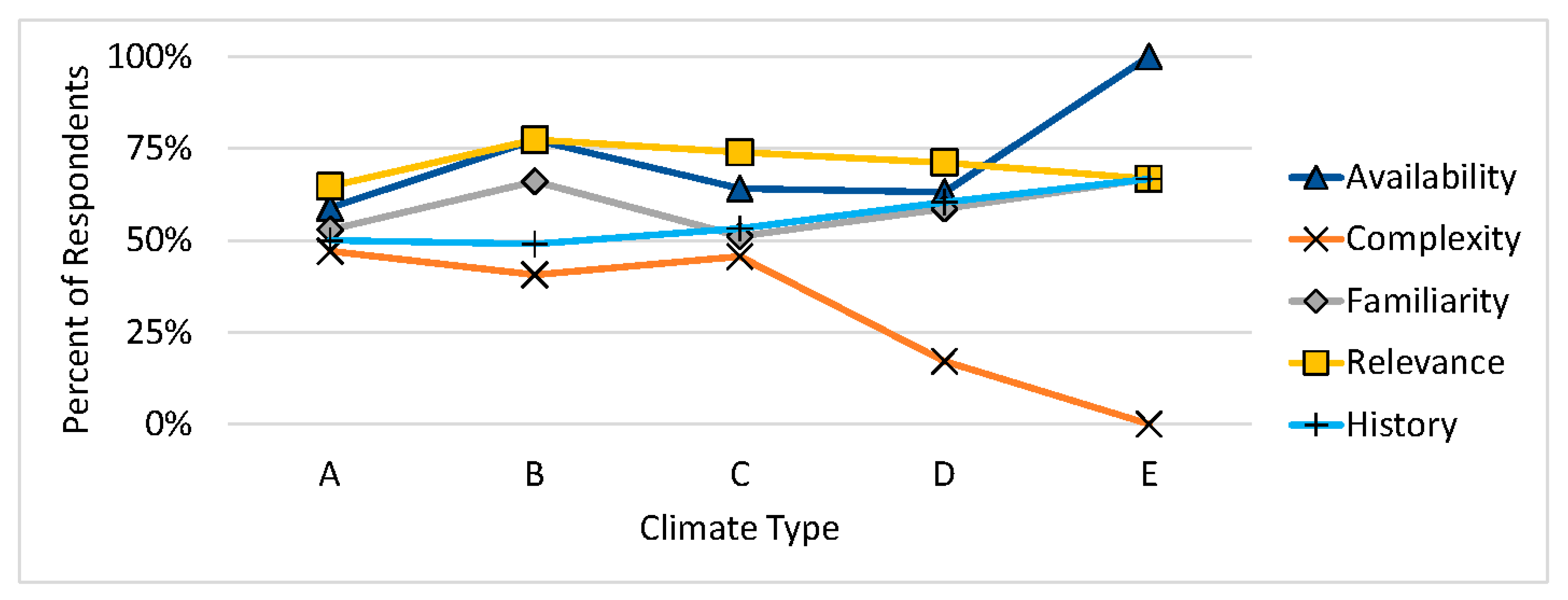
The factors affecting the choice of indicators were rated on a scale of 1 (not important) to 5 (very important). Two factors were rated as important to very important by wide margins across all five climate types: relevance of the index or indicator to my area/region and availability of relevant and required data to calculate the index or indicator (
Figure 5). Familiarity with the specific index or indicator was also rated as important to very important across all five climate types, but by narrower margins. The history of indices and/or indicators used previously in my area/region was important to very important for the majority of respondents in C, D, and E climates, but with narrower margins; this factor was so rated by 50% of the respondents in A climates and 49% in B climates. Complexity or difficulty of the required calculation was rated as important to very important by less than half of the respondents in all five climate types.
The ratings at the subzone level were consistent across most subzones for availability of relevant and required data to calculate the index or indicator—only the Cwc and Dsc subzones departed from the climate type statistics, with less than 50% of the respondents rating this factor as important to very important, but it should be noted that each of these two subzones had only three respondents. Relevance of the index or indicator to my area/region was rated important or very important by more than half of the respondents in each subzone except Dfd (which had only four respondents) and Dsc. Familiarity with the specific index or indicator was rated important or very important by more than half of the respondents across all A, B, and E climate subzones, but not consistently so rated across the C and D subzones, with a wide variation in responses (those subzones so rating this factor included Cfa, Cfb, Csa, Dfa, Dfb, Dfc, Dfd, Csa, Dsc, Dwa, Dwb, and Dwd). Half or more of the respondents in about half of the subzones (Af, Am, BSk, Cfa, Cfb, Cfc, Csa, Dfa, Dfb, Dfc, Dsa, Dwa, Dwb, Dwd, EF, and ET) rated history of indices and/or indicators used previously in my area/region as important or very important, while about half did not. Complexity or difficulty of the required calculation was so rated only in Am, BSh, BWh, Cfb, and Cwb subzones.
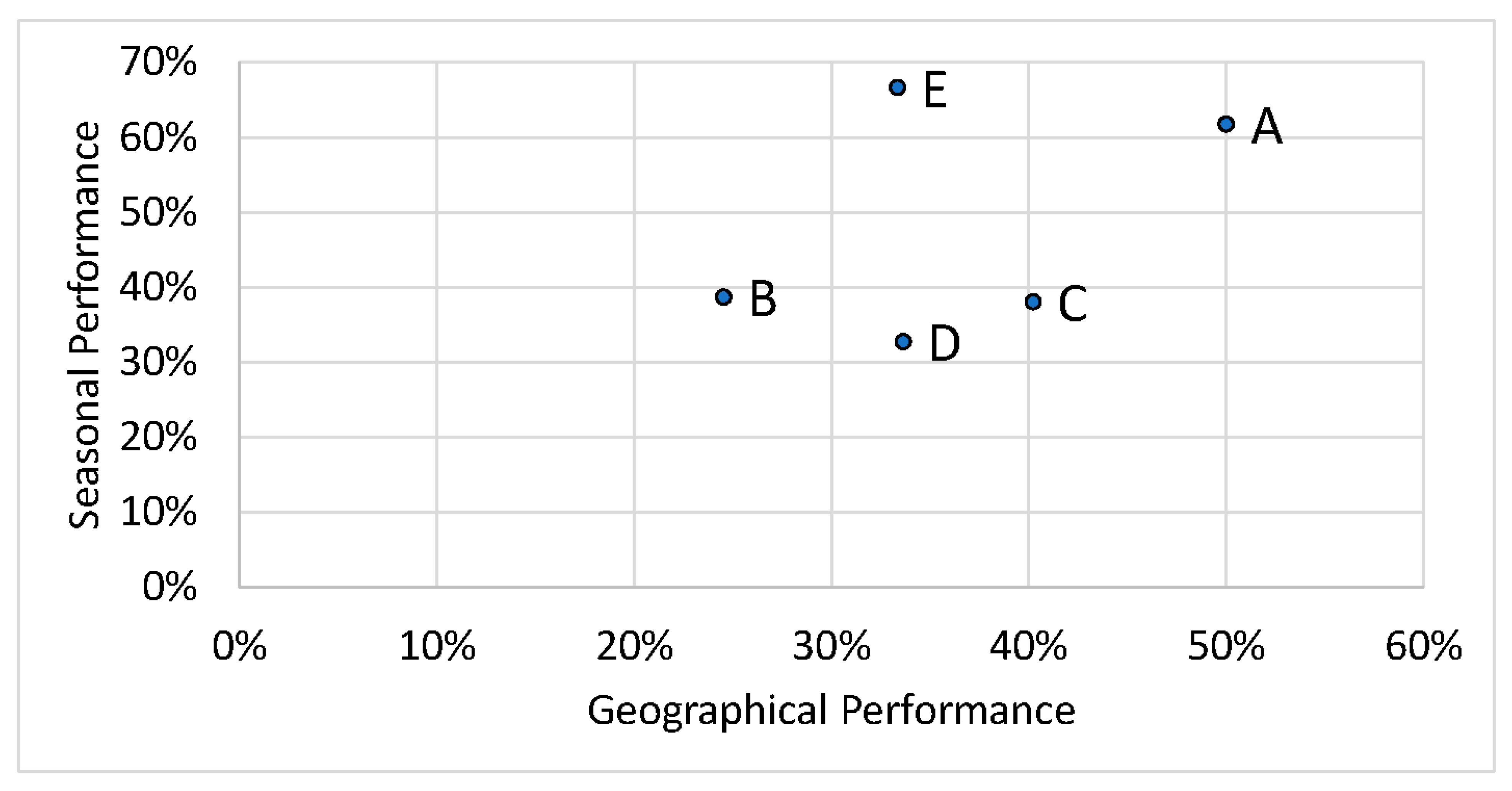
The perceived performance of drought indices and indicators, in the aggregate, was evaluated spatially and across seasons.
Figure 6 plots the percent of the respondents who indicated the indices performed equally well across seasons versus the percent of the respondents who indicated the indices performed equally well geographically for the five climate types. Indices in A climates had the highest combined performance. In C climates, indices had the second-best performance geographically. Indices in D climates had the poorest overall performance across seasons, although the B, C, and D evaluations clustered near each other on the seasonal performance scale. Indices in B climates had the poorest overall performance geographically. Indices in E climates had the best overall seasonal performance, although it should be pointed out that the sample size for E climates was small (seven total respondents) and this may skew the results.
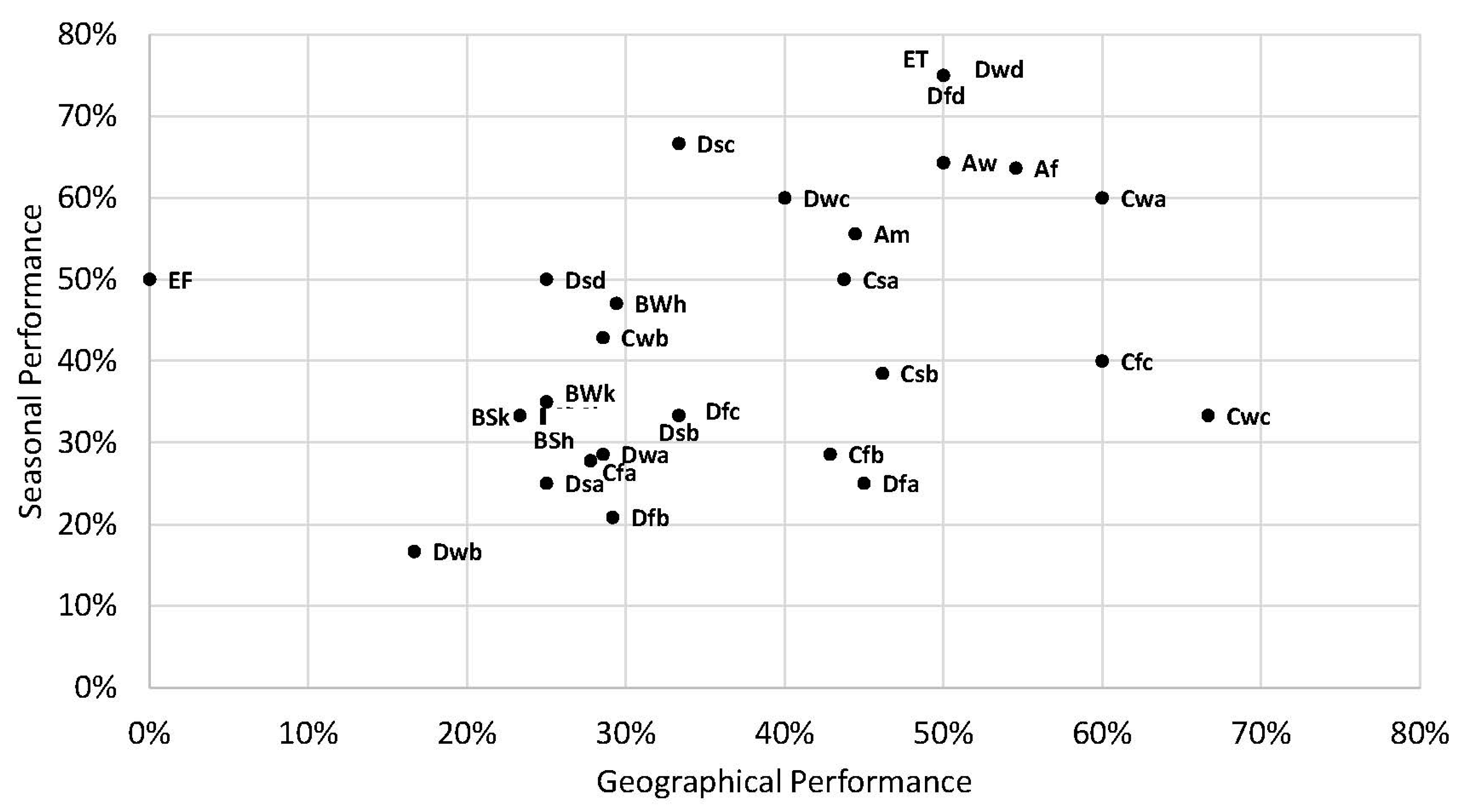
The seasonal vs. geographical perceived performance within the climate subzones is similar to the performance of the climate types for the A and B climates, but varies widely for the C, D, and E climates (
Figure 7). The sample size of the subzones in the A and B climate types ranges from nine respondents (Am) to thirty (BSk). The sample size for the C climate subzones ranges from three (Cwc) to eighteen (Cfa), for the D climate subzones ranges from three (Dsc) to twenty-four (Dfb), and for the E climate subzones includes two (EF) and four (ET). Some of the subzones with a low sample size had high overall performances (e.g., Cwa, Cwc, Dfd), while some had low overall performances (e.g., Dwa, Dwb, Dsd), so if sample size was a factor in subzone performance, its influence was not consistent.
4.3. User-Engagement Workshop Data
The data provided by user engagement at the workshops held over the past decade are grouped and discussed by climate type. The discussion can be found in the
Supplementary Materials in section S-4. The workshop data are supplemented by published research [
36,
46,
48,
49,
50,
51,
52,
53,
54,
55,
56,
57,
58,
59,
60,
61,
62,
63,
64,
65,
66,
67,
68,
69,
70,
71,
72,
73,
74,
75,
76,
77,
78]. These workshop and published data supplement the CEC survey results and include discussion of drought indices, drought-monitoring methodologies, and drought impacts. They are summarized in
Section 5 of this paper.
5. Discussion
This section summarizes the survey and workshop results and published literature to conclude with recommendations on the use of drought indices and indicators in the climate zones of North America. It includes a discussion of drought impacts and vulnerabilities, evolving drought indicators in a warming climate, and embedding indicators within robust decision systems.
5.1. Consolidated Summary of the Survey and Workshop Results
While recognizing that those who participate in surveys and workshops represent only a portion of all drought-indicator users, some conclusions about drought and the performance of the drought indices and indicators can be drawn from the CEC survey and workshop results. In Tropical (A) climates, more humid Temperate (C) climates (those with precipitation year-round or a wet season in the summer), and more southerly Continental (D) climates, respondents generally perceived droughts to last less than 6 months. This may be related to the greater chance of drought-ending rains occurring during the warm season when evapotranspiration is high. In Polar Tundra (ET) climates, Dry (B) climates, Temperate (C) climates with dry warm seasons, and more northerly Continental (D) climates, respondents generally perceived droughts to last longer than 6 months. This may be related to the smaller chance of drought-ending rains occurring during the warm season when evapotranspiration is high (dry summer climates) and the climatological deficit of water supply (precipitation) related to water demand (evapotranspiration) in Dry climates. In Temperate climates with no dry or wet season (f qualifier), there is potentially ample opportunity for drought-ending precipitation any time of the year, thus resulting in shorter-duration droughts.
Agricultural drought and hydrological drought were considered to be the most important drought types across all five of the major climate types (A, B, C, D, E) and all of their subzones. This is not surprising, considering the historical importance of an adequate food supply and adequate water for sustaining civilization. Since our society places an emphasis on drought impacts on agriculture and water supplies, staff in charge of drought monitoring will reflect those priorities by stating in a survey that those are most important. Meteorological and ecological drought were also important in all five of the major climate types and most of the subzones, but by smaller percentages. Socioeconomic drought was important in E climates, most D climate subzones, and some A, B, and C subzones.
Considering the importance of agricultural and hydrological drought, impacts related to crop and ranching losses and impacts related to water supply (reservoirs, lakes, and ponds) were rated high in all of the major climate types. Also of concern in all of the major climate types were various ecosystem impacts (wetlands, forests, wildlife habitat, health of wildlife) and, specifically, the threat of wildfires. In four of the climate types (A, C, D, E), drought impacts on human health were an elevated concern.
The CEC respondents across all five of the major climate types identified the most important factors affecting their choice of drought index as availability of relevant and required data to calculate the index or indicator and relevance of the index or indicator to their area/region.
The performance of the drought indices and indicators across seasons and geographically was rated in the aggregate. The majority of respondents indicated that indices and indicators performed equally well across seasons in Tropical (A), Polar Tundra (ET), and colder Continental (D) climates, but did not perform equally well in Dry (B), Temperate (C), and warmer Continental (D) climates. Respondents indicated that indices and indicators did not perform equally well geographically in four of the main climate types (B, C, D, E), with responses almost evenly divided for Tropical climates.
The WMO
Handbook of Drought Indicators and Indices lists 50 of the most commonly used drought indices and indicators that are being applied across drought-prone regions [
19] and the Handbook’s authors noted that it was not an exhaustive list. As seen in
section S-3 of the Supplementary Material, only a subset of those indicators and indices is widely used in North America—basically those the survey respondents and workshop participants were familiar with and that they considered were relevant to their area or region. It should be noted that the WMO
Handbook lists indicators and indices used worldwide, and some may not be used in North America, so the respondents were more likely to rate the indices that they are familiar with more highly. This is a form of respondent bias. The preceding paragraphs have already noted the importance of agriculture to human society, and this is reflected by the fact that approximately half of the CEC survey respondents worked in the field of agriculture [
43]. Thus, in the following discussion evaluating drought indices and indicators, it should be kept in mind that the results of the CEC study reflect human perceptions more than an objective comparison of the drought indices.
Of the indices and indicators not included in the WMO
Handbook, in general, the following were rated as effective or very effective for at least one subzone in all five major climate types: soil moisture; reported drought impacts; crop status; reservoir storage; vegetation greenness; groundwater depth; streamflow; precipitation departures from normal; precipitation percentiles; precipitation ranks; temperature departures from normal; temperature ranks; and water use (demand). In addition, several newer indices that are not in the WMO
Handbook are becoming more widely used. These include the Evaporative Demand Drought Index (EDDI) and snow water equivalent (SWE), which are used often in the western U.S. As noted in
Supplementary Material section S-4, the February 2020 Alaska workshop also identified SWE and EDDI as appropriate for south-central and southern interior regions of the state.
The most effective drought indices and indicators for either short-term or long-term drought, or both, across most of the subzones in all of the five major climate types, according to the CEC survey results and workshop participants, were the USDM, Standardized Precipitation Index (SPI), precipitation percentiles, another measure of precipitation (such as precipitation ranks, departure from normal), Normalized Difference Vegetation Index (NDVI) (or another satellite-observed vegetation index), a measure of temperature anomaly (departure from normal, ranks), crop status, soil moisture, streamflow, reservoir storage, water use (demand), and reported drought impacts. Percent of Normal Precipitation (PNP) was rated in the most effective category in four of the major climate types (all except E). The Standardized Precipitation Evapotranspiration Index (SPEI) was rated in the most effective category in subzones of four of the major climate types (all except A). Groundwater depth was rated in the most effective category in all of the major climate types except D and E. Wildfire locations/reports were rated in the most effective category in subzones of all of the major climate types except E. Other indices and indicators that were rated highly in some subzones of one or two major climate types include the Evaporative Stress Index (ESI) (A and C climates); Vegetation Drought Response Index (VegDRI) (C, B, and E climates); Soil Moisture Anomaly (SMA) (C climates); Soil Moisture Deficit Index (SMDI) (A and C climates); Crop Moisture Index (CMI) (C climates); SWE (B and D climates); EDDI and ephemeral ponds (D climates); and Surface Water Supply Index (SWSI) and water quality (E climates).
Evapotranspiration-related indices and indicators (such as SPEI or EDDI) did not appear to be as important in climates where evapotranspiration is high year-round and exhibits little variation that could be picked up by these indices and indicators.
The Palmer Drought Severity Index (PDSI) was rated as effective in Tropical climates for long-term drought. It was also rated effective in Polar climates, but this may be a spurious result, considering the small sample size for Polar climates and the fact that a few of the CEC respondents had responsibility for drought-monitoring continent-wide and the survey was not structured to individualize responses from such individuals (the indicators they selected were applied to all of the climate subzones in their area of responsibility).
5.2. General Insights Regarding the Use of the Drought Indices and Indicators
As noted by survey respondents and workshop participants, seasonal variations in precipitation and temperature impact the performance of indices and indicators that are based on these variables. The indices and indicators include SPI, various measures of precipitation anomaly (percentiles, ranks, departure from normal, percent of normal), SPEI, EDDI, ESI, and various measures of temperature anomaly (departure from normal, ranks). Precipitation during the wet season will have a greater impact on drought evolution than precipitation during the dry season, so precipitation-based indices are more effective during the wet season. Likewise, evapotranspiration during the warm season will have a greater impact on drought evolution than during the cold season (for those climates with pronounced seasonal swings in temperature), so temperature and evapotranspiration-based indices will be more effective during the warm season.
Continental and Polar climates typically have cold winters during which the ground becomes frozen for a period of time. The state of the ground affects water flow, so soil moisture-based indices and indicators are most useful during the warm season when the ground is unfrozen. These indices and indicators include SMA, SMDI, and soil moisture observations and model output (from the CEC survey results), as well as satellite-based indices not mentioned in the survey results, such as SMOS (Soil Moisture and Ocean Salinity satellite) soil moisture anomaly and SMAP (Soil Moisture Active Passive) volumetric measurements. Hydrological indices such as streamflow and ephemeral ponds are most useful during the warm season when the streams and ponds are unfrozen.
In cold climates (E, D, and some C and B climates), vegetation becomes dormant during the winter, which renders indicators and indices that incorporate vegetation health less useful during winter. These include NDVI, Enhanced Vegetation Index (EVI), CMI, and VegDRI. Crop status for annual crops (in B, C, D, and E climates) is most effective during the growing season, while crop status for perennial crops (in A climates) is effective year-round.
The SPI was rated highly in many climate regions. This index is an effective measure of the water-supply component in the drought equation and provides a statistically precise historical context. The SPEI is a better measure than the SPI, especially for flash droughts, because it measures the total moisture status—i.e., both water supply and water demand. But SPEI was not rated as highly as SPI in the CEC survey. This may be due to precipitation data being more widely available than temperature data (only precipitation data are needed to compute SPI, while both precipitation and temperature data are needed to compute SPEI). At a December 2009 workshop (the Inter-Regional Workshop on Indices and Early Warning Systems for Drought, sponsored and organized by the WMO, NDMC, University of Nebraska-Lincoln School of Natural Resources, NOAA/NIDIS, USDA, and the United Nations Convention to Combat Desertification Secretariat) in Lincoln, Nebraska, the organizers recommended that the SPI be used to characterize meteorological droughts around the world [
79], so this may also be a factor in the SPI’s popularity.
Percent of normal precipitation (PNP) was also rated highly in many climate regions. Many reasons were given by participants at the 8 October CEC webinar for why they used the PNP over the SPI. These include:
greater familiarity with PNP than SPI,
PNP may be in a regional drought-response plan while the SPI is not,
the period of record may not be long enough to compute the SPI but is long enough for PNP.
It was noted at the webinar that, unlike the SPI or precipitation percentiles, PNP by itself only relates precipitation to some base period mean; it does not provide a historical context for the precipitation anomaly. SPI is. Therefore. a better index than PNP for assessing the severity of a drought. PNP can be supplemented with historical information to overcome this shortcoming.
In situ-based drought indicators and indices provide information for point locations and are based on observed hydrometeorological data. Satellite-based indices and indicators provide better spatial coverage than in situ data in areas where station networks are sparse, but they are derived from algorithms based on radiometric data and the satellite record is generally shorter. The shortcomings for both in situ and remotely sensed data can be overcome by merging the datasets. For example, statistical or machine learning techniques could be applied to place satellite-based indices into a firmer historical context. One example of this sort of middle ground is McRoberts and Nielsen-Gammon [
80], which combines the spatial coverage of radar with the historic record of in situ stations.
The USDM was scored in the CEC study as consistently effective to very effective across most climate types and subzones for both short-term drought and long-term drought. This is likely due to several factors:
Its nature is composite—the USDM, like the CDM, MSM, and NADM, integrates the individual drought indices and indicators that are appropriate for the region and season being analyzed. It also integrates drought impact information that is provided by local field observers.
The USDM has some longevity and is widely accepted as an official product. With the majority of the survey respondents from the U.S. and the USDM a recognized official product with extensive media exposure, the respondents are likely more familiar with the USDM than they are with some of the other indicators and indices.
The U.S. borders both Canada and Mexico, with climatic conditions overlapping the borders, making the USDM useful to all three countries, especially in areas near the border. For example, the vast majority of the Canadian population lives in southern Canada, near the U.S. border.
The importance of ecological drought—particularly in Temperate and Continental climates—was highlighted in numerous engagements described earlier in this paper. To more effectively monitor ecological drought and drought impacts on ecosystem goods and services, further research is needed to understand ecological drought sensitivity and ecosystem responses to drought and to identify drought indices and indicators that are most appropriate for ecological drought. These and other key ecological drought research gaps and needs were identified through a series of four webinars co-organized by NIDIS and the USGS National Climate Adaptation Science Center in 2021.
5.3. Recommendations on the Use of Drought Indices and Indicators
Vicente-Serrano et al. [
81] noted “the necessity of testing and comparing
the local performance of different drought indices to select
the most appropriate one according to the variable of interest” (emphasis added) and “studies comparing the performance of several drought indices, like those evaluated here, would be preferable to determine the best drought index for identifying a certain drought type and its impacts on different systems.” It was in this spirit that the CEC study and the user-engagement workshops described herein were conducted—to identify those drought indices that are most appropriate for local climatic conditions, here
based on user preference. But it is acknowledged here that further research employing empirical studies based on objective data is still needed. In this section, we combine the survey results with a literature review of some of the existing objective research. It is hoped that this effort will provide a guide for selecting the appropriate drought index for specific climate zones.
5.3.1. Overview of Published Objective Research
This section provides an overview of the published literature that has objectively evaluated the effectiveness of drought indices and indicators. A more detailed discussion of the literature can be found in
section S-5 in the Supplementary Material.
AghaKouchak et al. [
82], Anderson et al. [
83], and Otkin et al. [
84] evaluated vegetation cover condition, as sampled by remotely sensed shortwave vegetation indices, and concluded that it may be effective in detecting rapidly changing conditions related to flash drought. Houborg et al. [
85], McDonough et al. [
86], Tavakol et al. [
87], Ma et al. [
88], and Beck et al. [
89] evaluated new indices that have been developed to monitor soil moisture using orbital sensors. The GRACE (Gravity Recovery and Climate Experiment), SMOS (Soil Moisture and Ocean Salinity), and SPoRT (Short-term Prediction Research and Transition) products show promise in measuring soil moisture during the warm season.
Several researchers [
15,
16,
17,
51,
66,
81,
90,
91,
92,
93,
94,
95,
96,
97,
98,
99,
100,
101,
102,
103] have evaluated the effectiveness of the SPI and SPEI. Dai [
51], Ellis et al. [
94], Quiring [
97], and White and Walcott [
95] noted that the SPI is based only on precipitation and does not consider evapotranspiration, which makes it more suited to monitoring meteorological and hydrological droughts rather than agricultural drought, although Quiring [
97] and Vicente-Serrano et al. [
81] concluded that it is more effective than PDSI, Palmer Z Index, Effective Drought Index (EDI), and percent of normal precipitation. Quiring [
97] also noted that, since percent of normal precipitation only relates precipitation to a base period and not to the historical variation in precipitation, it cannot be used to compare drought conditions over space or time. Naumann et al. [
90], Vicente-Serrano et al. [
92], and Homdee et al. [
98] determined that the SPEI is more effective when compared with the SPI, but Vicente-Serrano et al. [
91] concluded that the SPEI shows different sensitivity to precipitation and reference evapotranspiration as a function of the climatology and Faiz et al. [
99] noted that the SPEI is not suitable for colder regions where winter temperatures are mostly below zero and potential evapotranspiration is essentially zero. Seasonality is also important in the application of the SPI [
22,
66,
101], with the SPI more effective during the wet season than during the dry season. Yihdego et al. [
15] noted that the SPI’s short-term time scales (e.g., 1-month SPI) are more useful for evaluating soil moisture and crop stresses, while long time scales (e.g., 12-month SPI) have been tied to streamflow, reservoir, and groundwater levels. Dai [
51] noted that the PDSI and Palmer Hydrological Drought Index (PHDI) do not work well over mountainous and snow-covered areas, but PDSI can be used as a drought index over the low and middle latitudes.
Multiple index comparisons were carried out by several researchers [
21,
22,
91,
104,
105]. Keyantash and Dracup [
21] found that rainfall deciles and the SPI were the best drought indices for monitoring meteorological drought, total water deficit was best for hydrological drought, computed soil moisture was best for agricultural drought, and the precipitation anomaly was not especially informative because of its lack of historical context. Wanders et al. [
22] determined that all indicators, except those based only on precipitation, have difficulty in EF climates, where temperatures are below freezing for much of the year; this is especially true for streamflow and soil moisture, but also problematic for precipitation that accumulates as snow that will melt only when temperatures rise above freezing. Vicente-Serrano et al. [
91] showed that the highest correlations of SPEI and Reclamation Drought Index (RDI) with precipitation occurred in Mexico, the CONUS, and western and southern Canada. The highest correlations with reference evapotranspiration occurred from northern Mexico to the western CONUS and across western Canada. The lowest correlations with both precipitation and reference evapotranspiration occurred over parts of Alaska and northern and eastern Canada (boreal regions of North America). Low correlations with reference evapotranspiration also occurred in equatorial regions. In a study to quantify the time taken for drought to evolve from precipitation deficits to deficits in soil moisture or streamflow, Gevaert et al. [
105] determined that drought propagation is strongly related to climate type. They concluded that 1) droughts propagate slower in dry and continental climates and quicker in tropical climates and 2) winter-season drought propagation tends to be slower than in the summer, especially in tropical savanna and continental climates.
5.3.2. Recommendations Summary
The indices and indicators recommended for use in the five climate zones, based on the references cited above and in
Supplementary Material section S-5, plus Jain et al. [
106], Li et al. [
107], Lweendo et al. [
108], and Morid et al. [
109], are summarized in
Table 1. The discussion following the table is based on these studies, the CEC study, and the workshops discussed previously and in the
Supplementary Material.
Tropical (A) climates located near the equator (such as the USAPI) have high evapotranspiration year-round, which eliminates any advantage potential evapotranspiration-based indices have over precipitation-based indices. Weekly or monthly minimum precipitation thresholds are used as a trigger for drought in the USAPI; once a drought has been established, SPI values, precipitation percentiles or ranks, and impacts are used to determine the drought intensity. For tropical climates with precipitation year-round, the indices generally perform well throughout the year. Tropical climates located farther from the equator typically experience strong seasonal variations in precipitation, with the dry season occurring in winter. For such Aw climates, precipitation-based indices are most useful during the wet season.
Arid and semiarid (B) climates experience a chronic climatological lack of precipitation. In southern Alberta, southwestern Saskatchewan, and much of the western CONUS, winter is the wet season when large-scale synoptic systems bring widespread heavy precipitation and temperatures are cold enough for much of the precipitation to fall as snow in the mountains. The winter mountain snowpack serves as a “water tower”, and melting of the mountain snowpack during spring and summer feeds streams that provide a water source for the Southwest, Intermountain West, and much of the Pacific Northwest and West Coast during the summer dry season. Reservoirs collect streamflow and also serve as an important water bank for the West, where most of the agriculture is irrigated. Given the distinct dry season in the U.S. West and the extensive system of man-made reservoirs created to store and manage the water supply, it is of the utmost importance to use multi-year time scales for indices like SPI and SPEI when considering hydrologic drought. Extreme water shortages often take two years or longer to develop; a single year of drought can be buffered with little impact if large reservoirs are already nearly full. This has led to the development of drought-monitoring tools that offer access to drought index time scales of up to 72 months (e.g., [
110,
111]).
In addition, a recent study led by the University of Arizona highlights the complexities of monitoring drought in irrigated agriculture in the southwestern U.S. The study found that, where water supplies for irrigated crop production are in a different location than the land on which crops are produced, effective monitoring of drought impacts on agriculture may require the use of drought indicators, e.g., SPI and SPEI, for the watershed of the water-source location, rather than the crop-production area. This study emphasized the importance of considering the geographic and temporal scope of drought indices, the physical infrastructure and institutions that manage irrigation water, and the dynamic between water sources and the agricultural operations that use them in irrigated agricultural production.
Summer monsoon precipitation is critical for the U.S. Southwest and summer is the wettest time of year for many locations. As with Aw climates, in B climates, precipitation anomalies during the dry season can result in substantial SPI values but corresponding precipitation departures are small, so (as noted earlier) precipitation anomalies during the wet season are more likely to result in drought development, intensification, or amelioration. This makes drought indices based on precipitation amount, such as the SPI, less useful during the dry season and underscores the importance of using indices that incorporate atmospheric evaporative demand (like SPEI) or rely solely on evaporative demand (like the EDDI) at monthly to seasonal time scales. The dry season in the U.S. West is also the fire season and precipitation-based indices give little information with regards to in-season short-term fire danger. Drought indices that incorporate evaporative demand are therefore more appropriate for fire-danger monitoring and fire-management applications [
112].
The chronic lack of available water in arid climates hinders the growth and development of vegetation and limits actual evapotranspiration. When precipitation does occur, as from summer monsoon cells in the Southwest, vegetation can rapidly green up. This makes satellite-based greenness indicators important, not only to assess the productivity of grasses growing, but also as an indicator of where isolated monsoon cells have dumped rainfall and the spatial extent of that rainfall, which is often missed due to a low spatial density of station networks and radar gaps.
The temperature and precipitation regimes of the Temperate (C) climate zone make it ideally suited for growing annual crops. Sufficient precipitation is needed to maintain adequate soil moisture at certain times in the crop’s growth cycle, and high evapotranspiration can severely damage the crop, so precipitation-based and soil moisture-based drought indices are important. Satellite-based indicators can monitor the health, not only of crops, but of vegetation in the broader ecosystem. Temperate climates experience seasonal extremes in temperature (which contributes to evapotranspiration; it is noted that insolation, humidity, and wind speed also contribute to evapotranspiration [
113,
114]) and some have pronounced wet and dry seasons. Precipitation anomalies during the dry season are typically smaller than during the wet season; as a result, precipitation-based indices (PNP, SPI, and SPEI) are more effective during the wet season. Soil moisture measurements and indices are most important for agriculture during the growing season. Drought indices that measure some component of evapotranspiration (such as SPEI and ESI) are most effective when evapotranspiration is most significant, i.e., during the warm season. The combination of low precipitation and high evapotranspiration can contribute to the rapid development of “flash droughts”, which makes a combination of precipitation-based and evapotranspiration-based indices especially important. Streamflow provides the water source for filling reservoirs, which makes streamflow and reservoir storage important drought indicators for much irrigated agriculture in Cs climates.
The temperature and precipitation regimes of the warmer (a and b) and wetter (during the growing season) (f and w) subzones of the Continental (D) climate zone make it, like the Temperate climate zone, well-suited for growing annual crops. These D subzones are primarily limited to the northern U.S. and southern Canada. Unlike C climates, cold winter temperatures in D climates typically freeze the soils, with winter precipitation falling in frozen form (snow) and natural vegetation largely going dormant. The frozen soil and dormant vegetation limit the utility of soil moisture-based and vegetation-based indicators to the warmer times of the year. Below-freezing temperatures in winter reduce the amount of moisture the air can hold relative to the summer, so winter precipitation amounts are generally less than summer precipitation amounts (this is especially the case for the w subzones). The drier winters, and the fact that the snow accumulates during the winter and does not enter into the hydrological system until spring snowmelt, limit the usefulness of precipitation-based indices (such as SPI, PNP, and precipitation percentiles) during the cold season. The water content of the snowpack (SWE) is a better indicator of drought conditions during the winter than SPI, PNP, or total precipitation percentiles, but even then, SWE percentiles at the peak of the snow season (typically April) are a better measure than SWE percentiles earlier in the snow-accumulation season. The PDSI integrates water supply (precipitation) and water demand (potential evapotranspiration) with a soil-moisture component. The CEC survey results indicate it is more effective in the warmer D subzones than the colder ones. The factors above have been behind many of the criticisms of the PDSI [
5]. Modifications of the PDSI that address frozen soils and precipitation type (such as the Alberta model [
115,
116]) have improved its performance in D climates, and the self-calibrating PDSI (scPDSI) [
117] addresses issues with how the weighting factor K is computed in the original version.
Unique astronomical, geographical, hydrological, and meteorological factors complicate drought monitoring in the more northern D climate subzones of northern Canada and much of Alaska. The high-latitude location minimizes sunlight during the winter (zero solar insolation at the winter solstice north of the Arctic Circle), and long summer days maximize solar insolation and, consequently, potential evapotranspiration during the warm season. This results in a short but intense growing season for those limited agricultural areas. There is no significant irrigation for agriculture in Alaska, so precipitation during June–August is crucial, and the short growing season magnifies impacts on crops. Snow cover is typically continuous from 2 to 8 months, reducing the importance of short-term (i.e., monthly or less) precipitation deficits. During the warm season, streamflow is fed by snowmelt, rainfall, and groundwater, as well as meltwater from mountain glaciers. Streamflow needs to be used with caution as a drought indicator, since a summer warm/dry spell could result in above-normal glacier-fed streamflow, as opposed to below-normal streamflow, which would be the case in the warmer A-C climate zones. In the winter, rivers are frozen, which renders streamflow ineffective as a drought indicator during this time of the year. The permafrost layer is frozen year-round, but soil moisture in the active layer (the region where the ground thaws out above the permafrost layer) can be a factor in the warm season. As the soil thaws, even if it does not rain, the active layer will be wet, but it can dry out later in the warm season if precipitation is deficient. Frozen soils and continuous, long-duration snow cover render remotely sensed and modeled soil moisture indicators ineffective during the cold season, so they are most useful during the warm season.
5.4. Correlation of Indices with Drought Impacts and Vulnerabilities
As noted earlier in this paper, an index or indicator is only as good as its correlation with actual or potential drought impacts. The importance of correlating an indicator with actual conditions in the field was noted by many CEC survey respondents. Identification of drought indicators and indices that objectively correlate with drought impacts requires robust, sufficiently comprehensive databases of long-term drought impact data. While selected drought impact information is gathered for some locations and research projects have quantified and/or modeled the impacts of drought on specific sectors, significant improvements are needed in documenting drought impacts. For example, the 2021 workshop’s regional listening sessions in Alaska highlighted the impacts of a changing climate on local communities whose livelihoods are dependent on local resources. The loss of sea ice, changing animal migration patterns, and increased mortality of traditional foods, including seals, birds, caribou, fish, berries, and various plants, are a direct threat to the livelihoods and cultures of these communities.
In addition, drought impacts are modulated or exacerbated by ecological, socioeconomic, cultural, historical, and other assets and vulnerabilities. Important research questions center on improving our understanding of drought vulnerabilities and impacts and linking this information to drought indices to enable more reliable estimations of current and future impacts. This research is critical for effective mitigation of impacts and for targeted support for the most vulnerable, e.g., those subsistence-based communities who do not currently qualify for relief programs in the U.S. Some key gaps in understanding drought impacts include vulnerabilities of and impacts on socio-cultural and ecological systems; water security; community livelihoods and culture; economic sectors, including recreation; tourism; energy; and health.
5.5. Evolving Drought Indicators for a Warming Climate
Future drought may be substantially different from current and historical drought in frequency, severity, and extent [
118,
119], so it is important to understand how drought impacts and the nature of drought itself are changing over time [
120] in order to evolve drought indicators. For example, in the southwestern U.S., average annual precipitation has not changed significantly over the last 50 years, but aridity (lack of water availability) is increasing across the region due to temperature increases, which increase evaporation and contribute to early snow melt. Recent research [
121] characterizing the intensity, duration, and distribution changes of snow drought (SWE deficits) from 1980 to 2018 found that snow droughts intensified, lengthened, and became more common across the western U.S. and are projected to continue to increase across western North America (e.g., [
122]). Even when precipitation is at or above normal at higher elevations, warming temperatures can result in the precipitation falling as rain rather than snow, thereby weakening the SWE–precipitation relationship. Given the vital role of snow in the western U.S. and Canada for water supply, hydropower, agricultural production, ecosystems, etc., the study concludes that “characterizing snow deficits (snow droughts) in a changing climate has emerged as a critical knowledge gap”. That characterization is essential to adapt drought indicators and indices for the region and to incorporate accurate SWE measures into drought indices.
Similarly, at the 2021 drought workshops in Alaska, where temperatures are rising, resulting in rain rather than snow, and permafrost is rapidly degrading, participants noted that increased temperatures and the increasing length of the warm season (from 4 to 6 months) will increase evapotranspiration, thereby altering the signatures of drought. However, drought in high-latitude environments is complicated and not well-understood. For example, measuring evapotranspiration in Alaska is complex given the prolonged day-length in summer and short day-length in winter, and the melting of permafrost will affect the amount and depth of available soil moisture. Finally, there is limited data on key drought parameters, so improved instrumentation, continued maintenance of existing stations, and additional research are needed to understand how these and other variables will change in a warming climate and to adapt drought indices accordingly.
Studies cited by the IPCC [
123] indicate that there is an increase in the frequency and intensity of agricultural and ecological droughts and, in some parts of the world, meteorological and hydrological droughts. Also, there is a trend toward more short-term droughts in the U.S. than long-term droughts [
124] and flash droughts are becoming more frequent globally [
125]. Climate change studies indicate that these trends will continue [
123]. Hasegawa et al. [
126] and Gusyev et al. [
127] evaluated how drought will change under climate change scenarios using a comparative approach (calculating comparative standardized indices of future climates using the present climate as a reference). But perhaps more significant than the fact that the nature of drought will change is the impact of climate change on the stationarity of data, for this affects the foundation of all statistically based drought indices [
128]. In order to put current conditions into a historical context, raw values are standardized into anomalies using probability statistics. A reference period of record of at least 50–60 years is needed in order to empirically compute 50-year return periods (or a probability of recurrence of 0.02, which is the threshold for USDM exceptional [D4] droughts). Hoylman et al. [
128] argue that drought metric error and bias may be introduced where the climate has shifted substantially from the time-integrated period-of-record distribution. They conclude that non-stationarity in datasets caused by anthropogenic climate change needs to be accounted for in drought assessments based on statistically derived drought indices.
As temperatures warm and precipitation regimes change with a changing climate, the location and shape of the Köppen climate zones will change. This is not expected to affect the applicability of specific drought indices to specific climate zones, as only the geographic location of the climate zones will change, not the definition of the zones.
5.6. Embedding Indicators within Robust Decision Systems
The goal of improving drought indicators is to inform and improve decisions that increase resilience to drought and reduce the impacts of drought. Recommendations for strengthening the use of indicators in drought decision making (drought management and adaptation strategies) include:
Drought managers and decision makers who use drought indices and indicators in their operations are encouraged to follow the guidance in
Section 5.3.2 on the use of drought indices and indicators. This review paper, and especially
Section 5.3.2, is intended to serve as a “toolbox” to enable users to better utilize drought indices and indicators that are appropriate for their climate zone and their applications.
In several user engagements described in
Supplementary Materials Appendices S-A and S-D, it was noted that indicators need to be embedded in decision processes where a wide range of decision makers—including government, water providers, sectors impacted by drought, etc.—regularly communicate about drought in the region before drought hits. This is important for all regions, including those with limited drought experience. For example, participants at the 2021 Alaska drought webinar series noted that communities and decision makers associate drought with other regions of the country, such as the southwestern U.S., not Alaska. This highlights the need for targeted drought communication that is specific to Alaska. Improving awareness of the nature of drought and communicating about drought, its impacts, and the changing nature of drought with climate change across all climate zones is fundamental to catalyze proactive drought management.
While some indices have been designed to be universally applicable, no single drought index adequately describes all types of drought for all locations. The importance of location-specific indices was reflected in CEC survey responses, in which users commented that a major factor in their choice of indicator or indices was how “location-specific” the indicator is. Location-specific indices may capture the nuances of drought in relation to the local geography and soil types, water use and management, cultural considerations, sectors of importance locally, etc. However, given that droughts often extend over large geographic areas and multiple jurisdictional boundaries and impact shared surface and groundwater resources, interconnected economic sectors, social structures, etc., it is important for location-specific drought monitoring to be embedded within or linked to larger-scale drought monitoring and decision systems. Collaboration and communication among entities responsible for drought monitoring, mitigation, and response from local to national scales is important to ensure that local monitoring data, impact data, and information are compiled across regions to inform effective mitigation, response, and relief strategies at all scales.
Establishing a central, online location for drought indicators and indices could support improved access to and use of these tools for monitoring drought. An online resource could also support continued refinement and improvement of drought indicators and indices, especially to address issues caused by the changing climate such as the non-stationarity issue. Finally, it could allow users to share insights regarding the relevance and applicability of indicators and indices in specific locations, for specific sectors, etc., as a form of peer-to-peer learning that strengthens drought-management decisions.


 ,
, 


