Abstract
Based on atmospheric motion vectors (AMVs) derived from the Fengyun-4 meteorological satellite (FY-4), in this paper, integrated multi-satellite retrievals for GPM precipitation and reanalysis datasets and the vertical distribution characteristics of FY-4 AMVs, their application in the identification of the South Asian high (SAH) anticyclone and their application in the real-time monitoring of rainstorm disasters are studied. The results show that the AMVs’ vertical distribution characteristics are different across regions and seasons. AMVs from 150 to 350 hPa can be chosen as the upper troposphere wind (the total number accounts for about 77.2% on average). The center and shape of the upper tropospheric anticyclone obtained from AMVs are close to or slightly southward compared with those of the SAH at 200 hPa obtained from the ERA5 geopotential height. The SAH ridge line identified using the upper troposphere AMV zonal wind (the zonal wind is equal to zero) is slightly southward by about 1–2 degrees of latitude from that identified using ERA5 at 200 hPa but with a similar seasonal advance. The upper troposphere AMV can be used to monitor the location of the SAH and the evolution of its ridge line. The abnormally strong precipitation in South China is related to the location of the SAH and its ridge line. When the precipitation is abnormally strong/weak, the upper troposphere AMV deviation airflow shows divergence/convergence. During the “Dragon Boat Water” period in South China in 2022, strong precipitation occurred in the strong westerly winds or divergent flow on the northeast side of the upper troposphere anticyclone obtained from AMVs, and the precipitation intensity was the strongest when the divergence reached its peak, but this is not shown clearly in the EAR5 dataset.
1. Introduction
The South Asia high (the Tibetan high, SAH) is the atmosphere activity center of the upper troposphere over Asia in summer. SAH activity and droughts/floods in China have complex relationships comprising multi-scale interactions. As a strong and stable upper troposphere high-pressure system in the Northern Hemisphere, research has been conducted on its characteristics, influencing factors and climatic effects. The understanding of the SAH began with a global joint observation in the 1950s. Flohn studied the South Asian summer monsoon circulation and found warm high pressure in the upper troposphere over the Tibetan Plateau, that is, the SAH [1,2]. Mason and Anderson found that the SAH is the strongest at 100 hPa, ranging from the west coast of Africa to the east of the West Pacific, with east–west movement over the plateau [3]. The formation of the SAH is related to the heating of the Tibetan Plateau [4]; different atmospheric heating patterns in the southern Tibetan Plateau during summer caused by winter and spring snowfall will cause SAH anomalies. During the synoptic scale variation in the SAH, it is also affected by latent heat release from typhoon precipitation [5]. The SAH intensity index is generally defined by the geopotential height at 100 hPa [6] or 200 hPa [7].
The SAH shows obvious east–west oscillations and north–south movement characteristics at many different time scales. Tao and Zhu proposed a relationship between the SAH and the Northwest Pacific subtropical high, pointing out the concept of the east–west movement of the SAH [8]. The north–south movement of the SAH is closely related to the monsoon onset and the movement of the precipitation belt in China [9]. The east–west oscillations of the SAH and the interaction with monsoon circulation have an important impact on droughts and floods, as well as on the location and duration of precipitation in eastern China [10,11,12,13,14], and the SAH is also a leading signal of droughts and floods [15]. Li et al. studied the causes of the major drought in the Yangtze River Basin in summer 2022, pointing out that the strong eastward movement of the SAH caused descending airflow, which went against the precipitation [16]. Therefore, in the monitoring and early warning services for summer rainstorms, flood disasters and drought in China, the SAH in the upper troposphere is important, in addition to the characteristics of atmospheric circulation in the middle and lower troposphere.
Meteorological reanalysis data may deviate from the real state of the atmosphere due to the simulation deviation of the numerical models for extreme weather and assimilation methods of observation data. Satellite observations can simultaneously monitor planetary meso- and small-scale weather systems, as well as their interactions and configurations, reflecting the actual state and rapid evolution of the atmospheric phenomena and movements that occur. With the development of Fengyun meteorological satellites over the last 50 years, technical observations have significantly improved [17,18]. Fengyun geostationary meteorological satellites cover a wide range from Central Africa to the Central Pacific, and the polar-orbiting meteorological satellite made its first global observation at early morning and dusk in 2022. The atmospheric motion vectors (AMVs) derived from geostationary meteorological satellites, using three consecutive times of satellite cloud images by tracking the cloud or water vapor pixels, reflect the movement of clouds or water vapor at different pressure layers [19,20,21]. The time frequency of FY-4 AMVs (3 h for FY-4A AMVs) is obviously improved compared to that of FY-2 AMVs (6 h for FY-2 AMVs). FY-4B has been in operation since 2022, and the time frequency of its AMVs has reached 15 min for the full disk, which provides new application potential for the monitoring and warning of severe weather [22].
Weather and climate studies have been carried out using AMV data. Ren et al. [23] analyzed the application of the upper troposphere circulation revealed by Fengyun satellite water vapor channel AMVs in the analysis of heavy precipitation on the east side of the SAH, showing that the satellite water vapor images can present information on atmospheric motion in the middle and upper troposphere. Water vapor images and AMVs together can describe the upper troposphere anticyclone center and its ridge line, which has an important impact on the location and intensity of precipitation in summer in China. FY-4A AMV data have also been used in the data assimilation of numerical models and the analysis of catastrophic weather events, such as extreme rainstorms [24,25].
Previous studies on the application of AMV data in heavy precipitation mainly focused on qualitative analyses without giving the range of the vertical levels of the AMVs, which can represent the upper troposphere wind. In addition to quantitative analyses, SAH identification methods are needed for better applications. In this paper, based on FY-4 AMVs, the vertical distribution characteristics of AMVs are studied; then, the methods for identifying the SAH center and its ridge line (the zonal wind is equal to zero) are analyzed, and the application evaluation is complete. The application of the SAH and upper troposphere circulation using AMVs in the event of extreme heavy precipitation and drought in the summer of 2022 is carried out to benefit the real-time monitoring, evaluation and analysis application capability of the Fengyun meteorological satellite in extreme weather and climate events.
2. Data and Methods
2.1. FY-4 AMVs
- (1)
- FY-4A AMVs
FY-4A is the first satellite of the second generation of geostationary meteorological satellites in China, launched in December 2016 [17,26]. Since May 2017, FY-4A has drifted 104.7° E and was officially put into use in September 2017, marking the renewal of Chinese geostationary meteorological satellite observation systems. It carries four instruments, three of which are weather-related, namely, an advanced geostationary radiation imager (AGRI), a geostationary interferometric infrared sounder (GIIRS) and a lightning imager (LMI). FY-4A/AGRI is designed with 14 channels. The spatial resolution is 4 km for water vapor and far-infrared channels.
FY-4A AMVs are derived from three channels, namely, two water vapor channels (with center wavelengths of 6.25 μm and 7.1 μm) and one far-infrared channel (with a central wavelength of 10.8 μm) (Table 1). The altitude of the AMVs is determined by the water vapor height or cloud top height. The time frequency is 3 h starting at 0000 (UTC), the coverage area is an FY-4A full disk, and the data format is 229 × 229 grid points; each record includes wind speed, direction and pressure. The spatial resolution of FY-4A AMVs is 64 km. The average wind speed root-mean-square error is 4.5 m s−1 [24]. The data used in this paper are from 2020 to 2022. Figure 1 shows an example of FY-4A AMVs from a 6.25 μm water vapor channel and a 10.8 μm far-infrared channel.

Table 1.
FY-4 AMV data parameters.
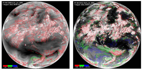
Figure 1.
FY-4A AMVs and cloud images on 1 August 2022 (6.25 μm water vapor channel and 10.8 μm far-infrared channel; red, green and blue vectors are for winds above 400 hPa, between 400 hPa and 700 hPa, and below 700 hPa, respectively).
- (2)
- FY-4B AMVs
The FY-4B satellite, successfully launched in June 2021, is the first operational satellite of the FY-4 series after FY-4A (scientific experiment satellite), marking the start of the operational development of a new generation of Chinese geostationary satellite observation systems, which is of great significance to ensure the upgrading of Chinese geostationary meteorological satellites and their continuous, reliable and stable operation. FY-4B carries four instruments, three of which are weather-related, namely, AGRI, GIIRS and a geostationary high-speed imager (GHI). Compared with FY-4A/AGRI, one new water vapor channel is added to FY-4B/AGRI. On 11 April 2022, FY-4B successfully fixed the geostationary orbit position over the equator at 133° E. On 1 December, the FY-4B satellite and its ground application system officially started operational work.
FY-4B AMVs are derived from four channels, namely, three water vapor channels (with center wavelengths of 6.25 μm, 6.95 μm and 7.42 μm) and one far-infrared channel (with a central wavelength of 10.8 μm) (Table 1). The altitude of the AMVs is determined by the water vapor height or cloud top height, similar to FY-4A AMVs. The time frequency is 15 min starting at 0000 (UTC), the coverage area is an FY-4B full disk, and the data format is 458 × 458 grid points; each record includes wind speed, direction and pressure. The spatial resolution of FY-4B AMVs is 48 km. The data used in this paper are from June 2022 for analyzing the diurnal variation characteristics of divergence in heavy precipitation events in South China.
2.2. ERA5 Reanalysis Data
The geopotential height, wind and divergence data are from the European Centre for Medium-Range Weather Forecasts (ECWMF) reanalysis dataset (ERA5), which combines a numerical model and global observation data with a grid spacing of 0.25° (longitude) × 0.25° (latitude) and a temporal resolution of 1 h, and the pressure layer used in this paper is 200 hPa [27].
2.3. GSMaP_Gauge Precipitation
The precipitation data are from the Japanese Global Satellite Mapping of Precipitation (GSMaP_Gauge) [28]. They include the latest Ku/Ka Doppler dual-frequency rainfall radar data and precipitation data retried by a microwave imager via an operation carried out by the Global Precipitation Measurement main satellite, and they integrate the precipitation from the global surface rain gauge observation. The grid spacing of GSMaP_Gauge precipitation is 0.1° (longitude) × 0.1° (latitude), and the temporal resolution is 1 h. The space coverage is (60° N–60° S, 0–360° E), and the data used in the paper cover the period from 2020 to 2022.
2.4. Vertical Layer Segregation of AMV
FY-4 AMV data records include wind direction, wind speed, longitude, latitude and pressure; that is, AMVs at different locations at the same time lie at different pressure levels. In order to show at which levels AMVs can represent the upper troposphere, the vertical distribution characteristics of AMVs are analyzed. The vertical distributions of the AMVs are calculated at intervals of 20 hPa between 10 and 1000 hPa. For example, the number of AMVs at 200 hPa is the total number of AMVs from 191 hPa to 210 hPa.
2.5. Study Regions
Satellite-derived AMVs are based on the movement of water vapor or clouds from three consecutive water vapor images or infrared cloud images. According to the US standard atmospheric profile, the peak of the weight function for channel 9 (6.25 μm) of FY-4A is 356 hPa (7.81 km), and the peak of the weight function for channel 10 (7.1 μm) of FY-4A is 490 hPa (5.79 km). This indicates that the above two water vapor absorption channels observe information in the upper atmosphere, mainly from the height near the peak of the weight function. The peak of the weighting function height of the water vapor channel varies with regions and seasons as a result of the different standard atmospheric profiles, and the average cloud top height also differs across climates. Therefore, in the study of the vertical distributions of the FY-4A AMVs, according to the main activity area of the SAH in the warm season (from April to September), three regions are selected (Figure 2). The eastern SAH is more important for the climate in East Asia, so the three selected regions are as follows: Region 1 (0–27° N; 66–140° E) belongs to tropical and subtropical areas and includes the Northwest Pacific, South China Sea, Indo-China Peninsula, Indian Peninsula, the Bay of Bengal and South China; Region 2 (27–40° N; 66–104° E) comprises the Tibetan Plateau and its surrounding areas; and Region 3 (27–40° N; 104–140° E) comprises central and eastern China, the Korean Peninsula, Japan and the Northwest Pacific.
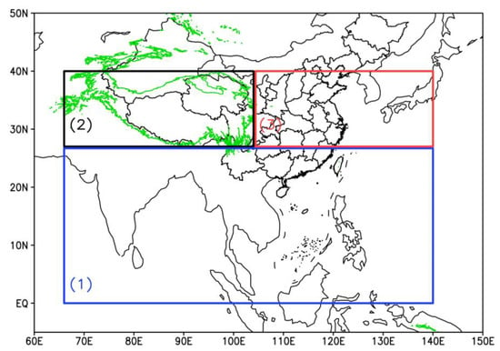
Figure 2.
Study regions and terrains (green contour line, 3000 m): Region 1 (blue, 0–27° N; 66–140° E), Region 2 (black, 27–40° N; 66–104° E), Region 3 (red, 27–40° N; 104–140° E).
3. Results
3.1. FY-4 AMV Vertical Distribution
The monthly number and percentage of AMVs at different pressure layers were calculated using FY-4A AMVs from 2020 to 2022 (Figure 3 and Figure 4) (the percentage of a certain pressure level of an AMV is the result of the number of AMVs at this pressure level divided by the total number at all pressure levels). The results show that the vertical distribution trend of an average AMV in Region 1 from April to September was almost the same but with a relatively small number in April and a large number in July, August and September. The distributions of the AMVs were concentrated between 100 hPa and 400 hPa, accounting for 90.19% in total, and the maximum number laid at 200 hPa, accounting for 12.56%. Between 160 hPa and 280 hPa, the number of AMVs at each level accounted for more than 5% and 66.18% in total.
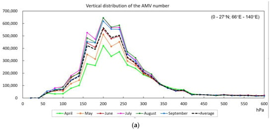
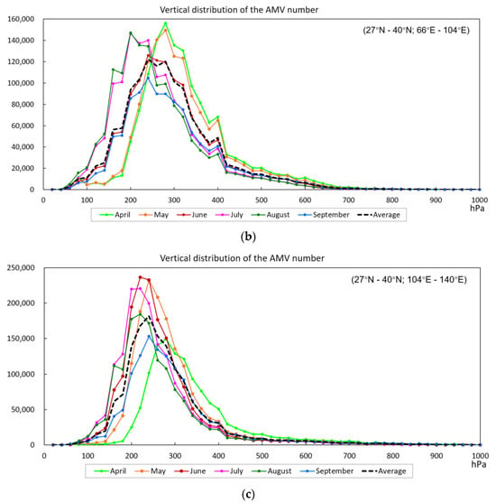
Figure 3.
Vertical distributions of monthly mean FY-4A AMV numbers from April to September: (a) Region 1, (b) Region 2, (c) Region 3.
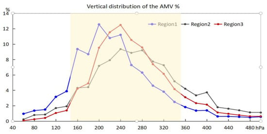
Figure 4.
Vertical distributions of monthly mean FY-4A AMV number percentage from April to September, the covered area is from 150 to 350 hPa.
Most of Region 2 consists of the Tibetan Plateau, and the vertical distributions of the AMVs were obviously different among months. The maximum number of AMVs was at 280 hPa in April and May but at a relatively higher level of 200 hPa in July and August. The vertical distribution in June and September was basically the same, with the maximum number around 240 hPa. AMVs between 100 hPa and 400 hPa accounted for 87.11%, and the maximum number appeared at 240 hPa, accounting for 9.35%. Between 160 hPa and 280 hPa, the number of AMVs at each level accounted for more than 5% and 62.66% in total.
In Region 3, the vertical distributions of the AMVs show that the number was less in April and September than in the other months. The maximum number of AMVs in April was at the lower level near 300 hPa, and in the other months, it was at 220 hPa or 240 hPa. The average maximum number from April to September was 240 hPa, which was slightly lower than that in Region 1 (200 hPa). The AMVs between 100 hPa and 400 hPa accounted for 90.88%. Between 200 hPa and 320 hPa, the number of AMVs at each level accounted for more than 5% and 67.20% in total.
There was a relatively small proportion of AMVs between 100 hPa and 400 hPa in Region 2 (87.11%). Region 2 consists of the Tibetan Plateau and its surrounding areas, with an altitude higher than 3000 m in most areas, and the total precipitable water in the atmosphere is relatively lower than that in Regions 1 and 3 (plains and ocean), resulting in weak convective development. Therefore, the cloud top height is relatively low in Region 2. This may be the reason for the relatively small proportion of AMVs between 100 hPa and 400 hPa in Region 2. Although there were differences in the vertical distributions of the AMVs in the three regions, the number of AMVs between 100 and 400 hPa accounted for more than 85% in all regions. In order to obtain as many AMV numbers and a smaller vertical range of the barometric layers as possible, the AMVs from 150 to 350 hPa were selected as the upper troposphere wind field. The statistics show that the number of AMVs in Regions 1, 2 and 3 from 150 to 350 hPa accounted for 77.9%, 72.4% and 81.3%, respectively, with an average of 77.2%.
3.2. The Monthly Mean Upper Troposphere FY-4A AMV Evolution
The monthly mean wind streams of upper tropospheric AMVs (from 150 to 350 hPa) and the geopotential height at 200 hPa showed that (Figure 5a1–a3) the upper troposphere anticyclone centers of the AMVs in April were located in the Northwest Pacific Ocean, east of the Philippines, in a tropical area, with a geopotential height of 1249 dgpm on the west side of the anticyclone center at 200 hPa. The South China Sea, South Asia, Southeast Asia, the Indian Ocean and the northwest Pacific to the north of 10° N had westerly winds. In May (Figure 5b1–b3), the upper tropospheric anticyclone centers of the AMVs were established in the central or central-west part of the Indo-China Peninsula. The geopotential height contour line of 1250–1252 dgpm at 200 hPa indicates that the SAH controlled the central part of the Indo-China Peninsula, with a similar anticyclone center showing in the upper troposphere AMV. The establishment of the SAH in the Indo-China Peninsula indicates the onset of the Bay of Bengal and the South China Sea summer monsoon. The upper troposphere AMV shows that it changed gradually from westerly winds to easterly winds from April to May in the South China Sea. To the northeast of the anticyclone center, there was outflow and divergence, which is conducive to summer monsoon convection and precipitation. In June (Figure 5c1–c3), the upper troposphere anticyclone centers of the AMVs laid on the south side of the Tibetan Plateau, and the SAH with a geopotential height of 1252 dgpm and a contour line at 200 hPa controlled most of the Tibetan Plateau, South Asia, Southeast Asia and Southeast China, which is similar to the anticyclone pattern shown in the AMVs. The geopotential height of 200 hPa near the anticyclone center of the AMV was about 1256 dgpm, and the center of the 1256 dgpm contour line was slightly north of the anticyclone center of the AMV. In July and August (Figure 5d1–e3), the upper troposphere anticyclone of the AMV controlled the Tibetan Plateau, South Asia, Southeast Asia, Southeast China and the Northwest Pacific. The centers of the upper troposphere anticyclone of the AMVs were located in the southwest or east-central (Figure 5e3) part of the Tibetan Plateau, which was closer to or slightly south of the center of the maximum geopotential height at 200 hPa. In September (Figure 5f1–f3), the upper troposphere anticyclone of the AMV moved to the southeast, close to the average position in June, with a similar center to that at the geopotential height of 1254–1258 dgpm at 200 hPa. Therefore, the monthly mean upper tropospheric anticyclone of the AMV had a similar center and shape to that of the SAH at 200 hPa and can be used in SAH monitoring.
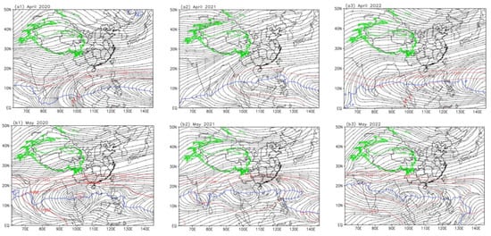
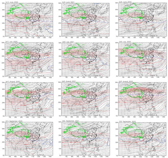
Figure 5.
The monthly mean wind streams of upper troposphere FY-4A AMVs (form 150 to 350 hPa), SAH ridge lines (blue line: zonal wind u = 0) and ERA5 geopotential heights (red, unit: dgpm, greater than 1246 dgpm with intervals of 2 dgpm) at 200 hPa from April to September in 2020–2022; the green counter line is an altitude of 3000 m; (a1)–(f1) are April to September 2020, (a2)–(f2) are April to September 2021, (a3)–(f3) are April to September 2022.
In addition to the central position and shape, the ridge line of the SAH is also important for precipitation (ridge line: zonal wind u = 0 in the anticyclone). Near and to the north of the ridge line on the east side of the SAH center, there is generally a strong divergent outflow, and to its north side, there is a westerly jet, which is conducive to the updraft and precipitation to the right side of the entrance region of the jet. Figure 6 shows the evolution of the ridge line of the SAH identified using the monthly mean upper tropospheric AMVs and ERA5 wind at 200 hPa.
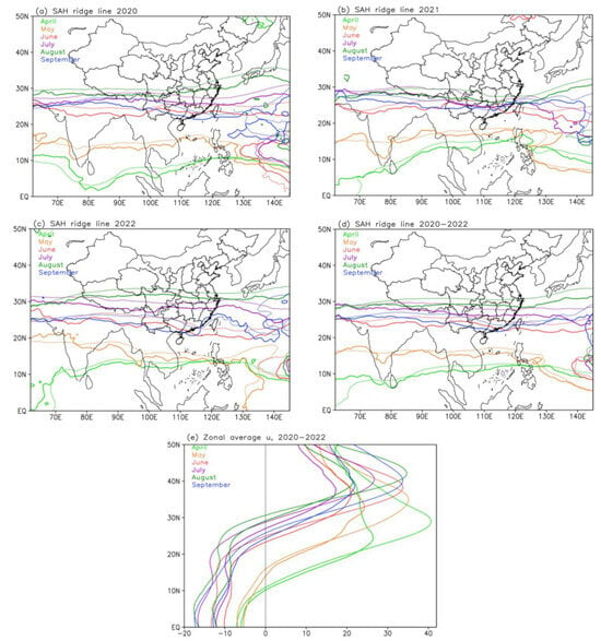
Figure 6.
The monthly mean SAH ridge line (zonal wind u = 0) from April to September 2020–2022 (thick solid line: FY-4A AMV from 150 to 350 hPa; thin dotted line: ERA5 wind at 200 hPa; different months are distinguished by colors): (a) 2020, (b) 2021, (c) 2022, (d) the average of 2020–2022, and (e) the zonal average u of 2020–2022 from 60° E to 145° E in longitude.
From 2020 to 2022, it can be seen in the annual distribution (Figure 5a–c) that, from April to August, the SAH ridge line gradually moved northward, reached its northernmost point in August, and began moving southward in September. The advancement process across the 3 years was similar, but there are a few differences in the position of the ridge line in the same month of different years. A comparison of the 3-year averaged SAH ridge line identified using AMVs and ERA5 wind (Figure 5d,e) shows that, from April to September, the SAH ridge line identified using AMVs was slightly southward by about 1–2 degrees in latitude from that identified using ERA5 wind, and the seasonal advance trend was consistent. Therefore, the monthly mean upper troposphere AMV anticyclone can be used to monitor the SAH and its ridge line. The difference in the SAH ridge line identified using AMVs from that identified using ERA5 also provides more observational facts that can benefit climate and weather monitoring.
3.3. Application of FY-4 AMVs in Climate Monitoring in China 2022
The SAH and the upper tropospheric divergence identified using AMVs can be used in the monitoring of disastrous climate and weather events. In 2022, abnormally strong precipitation in South China in June caused severe floods, and weak precipitation in July, August and September in central East China caused severe drought.
Using the FY-4A AMV data from April to September 2022, the relationship between the SAH and the precipitation was analyzed. Figure 7 and Figure 8 show the monthly averages and their anomaly (compared with the average from 2011 to 2020) distributions of wind streams and precipitation. In April and May 2022 (Figure 7a,b and Figure 8a,b), the SAH center began to move from the east of the Philippines to the southeast of the Bay of Bengal, and the precipitation began to increase in May to the northeast side of the SAH in South China.
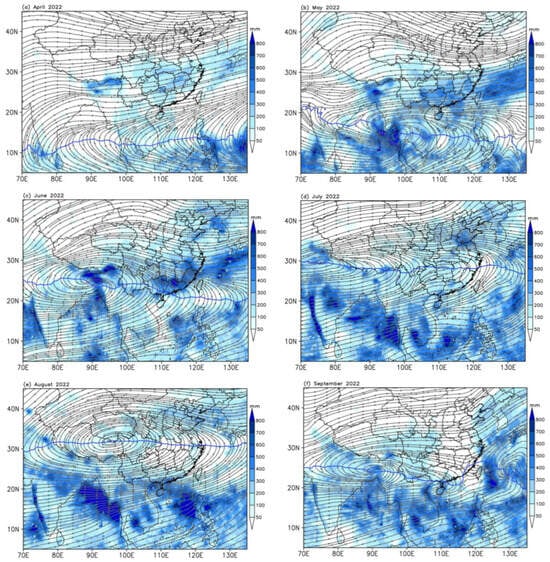
Figure 7.
The monthly mean wind stream of upper troposphere FY-4A AMV (from 150 to 350 hPa, gray stream line), SAH ridge line (zonal wind u = 0, blue line) and precipitation (shaded, unit: mm) from April to September in 2022, (a)–(f) are April to September 2022.
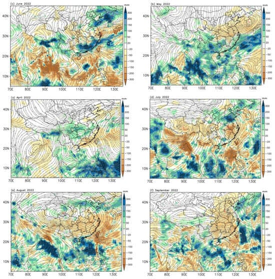
Figure 8.
The monthly mean anomaly wind stream of upper troposphere FY-4A AMV (between 150 and 350 hPa, gray stream line) and precipitation anomaly (shaded, unit: mm) from April to September in 2022; the climate average is from 2011 to 2020, (a)–(f) are April to September 2022.
In June 2022 (Figure 7c and Figure 8c), the SAH center laid in Bangladesh on the south side of the Tibetan Plateau, and the ridge line on the east side of the SAH center was located near 20–25° N, passing through the northeast of the South China Sea, South China and southern Yunnan Province in China. Heavy rainfall, more than 300 mm, occurred in South China, the eastern part of Southwest China and the southeastern part of the Tibetan Plateau to the north of the ridge line. In particular, the accumulated precipitation in South China and the central and eastern parts of the Yangtze River Basin in June exceeded 600 mm, resulting in serious flood disasters. Compared with the average of 2011–2020, the precipitation anomaly in the north of South China, in the middle and east of the regions south of the Yangtze River, was more than 300 mm. More precipitation also occurred in the southeast of the Tibetan Plateau, the northeast of China. It can be seen from the upper troposphere AMV anomaly that there was a cyclonic circulation anomaly in the central and eastern parts of China. More precipitation anomalies occurred in the divergent areas of the abnormal wind field, especially in the middle and eastern parts of the south of the Yangtze River Basin and South China. The anomalous westerly divergent airflow in the upper troposphere is conducive to strong precipitation.
In July 2022 (Figure 7d and Figure 8d), the SAH center laid in the southwest of the Tibetan Plateau, and the ridge line on the east side was pushed northward to 28° N, that is, from the south side of the Tibetan Plateau to the north of the Yangtze River Basin. Areas with strong precipitation of more than 300 mm were located in the eastern part of northwest China, northern China and northeast China. Except for Shanxi and Shandong Provinces, in northeast China and South China, precipitation in most of China was relatively low, especially in the southeast of China. The anomalous anticyclonic circulation (high-pressure) center in the upper troposphere of the AMV was located in the eastern part of Hubei Province and the western part of Anhui Province, and the anomalous cyclonic circulation (low-pressure) center was located in the Tibetan Plateau. The convergence (in favor of the downdraft in the mid- and low-troposphere) caused by the two anomalous circulations controlled most of China, resulting in less precipitation.
In August 2022 (Figure 7e and Figure 8e), the most prominent feature is that the center of the SAH, identified using the AMV, was to the north, located at the junction between Sichuan and Qinghai Provinces in the northeast of the Tibetan Plateau. The SAH ridge was near 32° N, and there was upper divergence in the north of China, which corresponded to strong precipitation of more than 300 mm. Conversely, the precipitation in the other regions of China continued to be relatively low. It can be seen from the abnormal circulation of the upper tropospheric AMV that the strong anticyclone center was in the north of Qinghai Province and that the abnormal anticyclonic circulation controlled almost the whole of China. Except for the western and central parts of northwest China and in the north of China, where the precipitation was slightly higher, other areas were controlled by the converging downdraft on the south and east sides of the upper troposphere anticyclone. In addition, the western part of the northwest Pacific Ocean was also controlled by the converging airflow with less precipitation. In the South China Sea, Indochina Peninsula, the Bay of Bengal and India near 10–20° N, the precipitation was strong, which was caused by the upper troposphere divergent abnormal airflow.
In September 2022 (Figure 7f and Figure 8f), the center of the SAH turned back to the vicinity of Bangladesh to the south of the Tibetan Plateau, and the ridge line was in the south of southwest China and the coastal region of South China. Precipitation in China mainly occurred in the eastern and southern parts of the Tibetan Plateau and in the eastern and southern parts of southwest China on the northeast side of the SAH, which is almost the same as the climate average. However, the precipitation in most areas of China east of 105° E continued to be weak, with abnormal convergent airflow in the upper troposphere centered in the north of Henan Province, and the precipitation in the northwest Pacific was strong due to typhoon activities.
The abnormally strong precipitation in South China in June and the weak precipitation in July, August and September 2022 were related to the center and the ridge of the SAH. The convergence and divergence caused by the abnormal circulation in the upper troposphere of the AMV had a good relationship with the abnormally weak and strong precipitation.
3.4. Application of FY-4 AMVs in Weather Monitoring in South China
During the “Dragon Boat Water” period from May 21 to June 21, 2022 (officially announced by the National Climate Center, China Meteorological Administration), there were many heavy rainfall events in the Pearl River Basin (Figure 9a). The four consecutive regional rainstorm periods (Figure 9c) are 23–31 May and 3–8, 10–14 and 17–20 June, which are characterized by large cumulative rainfall, frequent rainstorm events, many rainstorm days and extreme weather. The total precipitation in most areas was more than 400 mm, being 600–900 mm in parts of north-central Guangxi, north-central Guangdong, southern Hunan and southern Jiangxi Provinces; 1000–1300 mm in Guilin, Liuzhou, Hezhou, Qingyuan and Shaoguan cities; and a maximum of 1616 mm in the local area of Guilin city in Guangxi Province. The precipitation in most of the above areas was more than 50% higher than that in the same climate period, and the precipitation in northern Guangdong and northeastern Guangxi was 1–2 times higher. The average precipitation in the Pearl River Basin was 440 mm, 53% higher than that in the same climate period and the second strongest in the same period since 1961. Affected by heavy rainfall, more than 45 rivers in the Pearl River Basin exceeded the warning water level. On 21 June 2022, the Pearl River Flood Control General Administration upgraded the flood control emergency response to Level I. Waterlogging occurred in many places in Guangdong and Guangxi Provinces, having bad effects on transportation and agricultural production. On 9 January 2023, the press conference of the China Meteorological Administration announced the results of the selection of the “Top Ten Weather and Climate Events at Domestic and Abroad in 2022”. The persistent heavy precipitation event was selected as one of the “Top Ten Weather and Climate Events at Domestic in 2022” (the second strongest precipitation since 1961 during the “Dragon Boat Water” period in history affecting the Pearl River Basin).
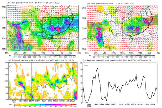
Figure 9.
The total precipitation and average upper troposphere AMV from 21 May to 21 June; (a) the total precipitation and average upper troposphere AMV from 17 June to 20 June; (b) the time series of regional (20–30° N; 105–120° E) daily average precipitation from 1 May to 30 June; (c) and the zonal mean (105–120° E) time series of daily average precipitation and the zonal wind u = 0 contour line (d) in 2022. The black dashed rectangle is the region (20–30° N; 105–120° E, Region 4), and the blue solid rectangle is the region (23–26° N; 107–116° E, Region 5) (precipitation unit: mm).
To monitor strong weather systems caused by convections, higher-temporal-resolution observation data are required. As mentioned in Section 2.1, FY-4B is a successor to the FY-4A satellite. The temporal resolution of FY-4B AMVs is 15 min, while the time resolution of FY-4A AMVs is 3 h. The historical data of FY-4A are long, and FY-4B only has stable and continuous high-quality data from 2022. Therefore, in the previous statistical analysis and climate monitoring application, FY-4A AMV data were used, whereas, in this section, FY-4B AMV data with a 15 min temporal resolution for catastrophic weather monitoring were chosen. During this period, the average upper troposphere anticyclone center in FY-4B AMVs was in the north of the Bay of Bengal, and the ridge line on the east side was near 20° N in the longitude range of 105–120° E and was about 5 degrees in latitude south of the strong precipitation area of more than 800 mm in South China. Strong precipitation of more than 400 mm lay in the westerly to northwesterly wind divergent flow of the upper troposphere anticyclone in the AMVs, and the westerly jet was located north of the strong precipitation. During the persistent rainstorm period from 17 to 20 June (Figure 9b), heavy precipitation occurred in northern Guangxi and northern Guangdong Provinces, with a maximum total precipitation of more than 400 mm. The average AMV in the upper troposphere during this rainstorm event is similar to the average of that from 21 May to 21 June, and the precipitation occurred in the divergent airflow on the northeast side of the upper troposphere anticyclone.
It can be seen from the regional (20–30° N; 105–120° E, region 4) daily average precipitation time series (Figure 9c) that it began to increase on 21 May and fluctuated several times until 21 June, remaining greater than 10 mm, and began to weaken on 21 June. The zonal mean (105–120° E) time series of the daily average precipitation and the zonal wind u = 0 contour line show that (Figure 9d) the ridge line of the SAH identified using AMVs rapidly pushed northward from 12° N to 20° N on 21 May. From 26 May to 21 June, the ridge line of the SAH moved back and forth in the north–south direction in the latitudes of 20–23° N, and the rainstorm areas also moved accordingly.
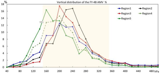
For the persistent rainstorm period from 17 to 20 June, the average vertical distributions of the FY-4B AMVs show that the total proportions from 150 to 350 hPa in Regions 1–5 are 82.0%, 92.2%, 89.4%, 86.6% and 87.1%, all of which are above 80% (Figure 10). Among them, the proportions of Regions 1–3 are relatively higher than the average proportions from April to September in Figure 4d; in particular, the maximum proportion of Region 3 is located at 200 hPa, which is higher than the average maximum position of 240 hpa from April to September, reflecting seasonal differences. The proportions between 100 hPa and 180 hPa in Regions 4 and 5 with strong precipitation in South China are greater than those in Regions 1–3, indicating that, during convective heavy precipitation, satellite-retrieved AMVs are concentrated at higher levels.
The impact of the SAH on heavy rain is partly due to the suction effect of the upper tropospheric divergent airflow formed by the SAH on the middle and lower tropospheric airflows, which is conducive to the development of updraft and the generation of strong precipitation. However, the release of the condensation latent heat of the heavy rain causes short-term variations in the SAH, forming a positive feedback effect. Figure 11 shows the divergence calculated from the upper troposphere AMV and the divergence at 200 hPa from the ERA5 time series. During the rainstorm event in the period of 17–20 June, the 1 h regional average (20–30° N; 105–120° E, the black dashed rectangle in Figure 9a,b) precipitation showed obvious diurnal variation. The precipitation began to increase or reach its peak at about 0000 UTC and decrease at about 1200 UTC, with the maximum 1 h precipitation at about 0000 UTC on 20 June.
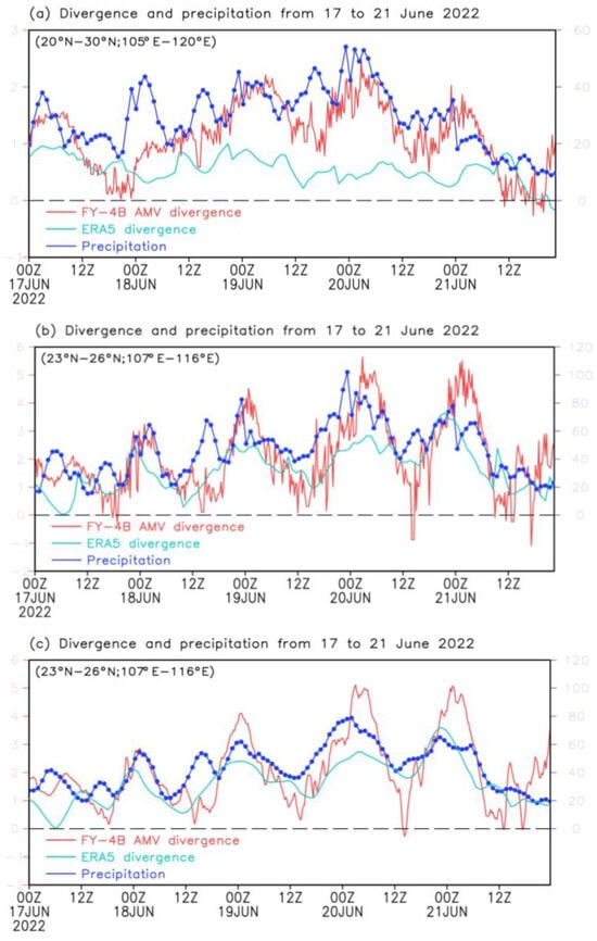
Figure 11.
The time series of the regional average upper tropospheric divergence from FY-4B AMV (red line, unit: 10−5s−1), divergence at 200 hPa from ERA5 (cyan line, unit: 10−5s−1) and 1 h precipitation (blue line, unit: mm) from 17 to 21 June 2022. (a) Region 4 (20–30° N; 105–120° E), (b) Region 5 (23–26° N; 107–116° E), (c) Region 5 (23–26° N; 107–116° E) but after low-pass filtering; regions are shown in Figure 9.
From the perspective of the overall trend of precipitation, it is consistent with the evolution of the upper troposphere divergence in the AMV. From 0000 UTC on 17 June to 2300 UTC on 21 June, the upper troposphere divergence in the AMV showed a wave characteristic with three ridges and four troughs. The ridges appeared at about 0600 UTC on 17 June, 0000 UTC on 19 June, 0000 UTC on 20 June and 0000 UTC on 21 June. The troughs appeared at 0000 UTC on 18 June, 1200 UTC on 19 June, 1200 UTC on 20 June and 1200 UTC on 21 June. The temporal evolution of 1 h precipitation is characterized by the superposition of smaller time-scale fluctuations. When the divergence of the upper troposphere of the AMV reached its peak, it generally corresponded to the strongest precipitation intensity. The regional average divergence at 200 hPa from ERA5 was positive (divergent) but did not show obvious wave characteristics. However, the relationship between precipitation and upper troposphere divergence may sometimes exhibit an inconsistent development trend because precipitation intensity is not only related to the upper troposphere divergence but also to various dynamic and thermodynamic conditions of the atmosphere, such as low-level convergence, water vapor transport, instability and updraft.
During the rainstorm from 17 to 20 June, there was strong precipitation in northern Guangxi and northern Guangdong Provinces (Figure 9b, the blue box region: 23–26° N; 107–116° E). The time series of the upper troposphere divergence in the AMV and 1 h precipitation in this region show that the wave characteristics of these two parameters have a more significant positive correlation. The regional average divergence at 200 hPa in ERA5 also has the same fluctuation characteristics as that of 1 h precipitation, but the intensity of the divergence is smaller than that in the AMV (Figure 11b,c).
The daily precipitation and AMV from 17 to 20 June show that there were persistent rainstorms in northern Guangxi, northern Guangdong, northeastern Jiangxi and northern Fujian Provinces (Figure 12). On 19 June, the rainstorm in northern Jiangxi and northern Fujian Provinces was the strongest, where the upper troposphere AMV was westerly with wind speed divergence. The maximum divergence on 17 June was about 3 × 10⁻⁵s−1, and the divergence in the heavy precipitation area was greater than 2 × 10⁻⁵s−1. The divergence was enhanced from 18 to 20 June, with a maximum divergence of 5~7 × 10⁻⁵s−1 to the southwest of the heavy rainfall area.
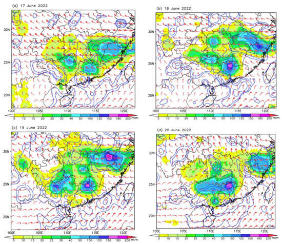
Figure 12.
The daily precipitation (shaded, unit: mm) and upper troposphere AMV (red barb) and divergence from AMV (blue line, unit: 1 × 10⁻⁵s−1) in period of 17–20 June 2022 (a)–(d).
4. Conclusions and Discussion
4.1. Main Conclusions
Based on FY-4 meteorological satellite-derived AMVs, ERA5 reanalysis data and GSMaP satellite-derived precipitation, a comparison and analysis of upper troposphere AMVs and the geopotential height at 200 hPa, as well as the identification of the SAH, were carried out. The main conclusions are as follows:
- (1)
- The vertical distributions of the FY-4 AMVs in the three regions showed that the characteristics were different across regions and seasons. The seasonal variation over tropical oceans was small, with the maximum number of AMVs at about 200 hPa. Over the Tibetan Plateau and East Asia, the vertical distributions of the AMVs were relatively lower, especially in spring and autumn. The number of AMVs between 100 hPa and 400 hPa accounted for more than 85% of the total. In order to obtain as many AMVs and a smaller vertical range of the barometric layer as possible, the AMV from 150 to 350 hPa was selected as the upper troposphere wind field. Statistics showed that the number of AMVs over the three regions from 150 to 350 hPa accounted for 77.9%, 72.4% and 81.3%, with an average of 77.2%.
- (2)
- The center and shape of the upper tropospheric anticyclone obtained from the AMV (from 150 to 350 hPa) were close to or slightly southward compared with those of the SAH at 200 hPa obtained from the ERA5 geopotential height. The SAH ridge line identified via the upper tropospheric AMV zonal wind (u = 0) was slightly southward by about 1–2 latitudes from that identified via the ERA5 zonal wind at 200 hPa but with a similar seasonal advance. The upper troposphere AMV can be used to monitor the location of the SAH and the evolution of its ridge line.
- (3)
- The abnormally strong precipitation in South China in June and the lower precipitation in central and eastern China from July to September 2022 were related to the location of the SAH center and its ridge line. During the abnormally heavy rainfall in South China in June, the SAH center was over Bangladesh to the south of the Tibetan Plateau, and the ridge line on the east side was stable at around 20–25° N. The abnormal circulation of the upper tropospheric AMV was divergent. During the abnormally weak rainfall from July to September, the abnormal circulation of the upper tropospheric AMV in the region with less precipitation was convergent. In particular, in August 2022, there was a continuous heat and drought event in the central and eastern parts of China; the SAH was strong, the center was abnormally northerly located over the northeast of the Tibetan Plateau, and the upper abnormal anticyclone circulation controlled the central and eastern parts of China.
- (4)
- During the “Dragon Boat Water” period in South China from 21 May to 21 June 2022, the ridge line of the SAH in the FY-4 AMV shifted from south to north at 20–23° N, and the rainstorm area to the north side also had corresponding oscillation. Strong precipitation occurred in the strong westerly winds or divergent flow on the northeast side of the upper troposphere anticyclone in the AMV. The regional average upper tropospheric divergence in the AMV and precipitation had the same phase fluctuation characteristics, and the precipitation intensity was mostly the strongest when the divergence reached its peak.
4.2. The Advantages of FY-4 AMVs in SHA Identification and Rainstorm Monitoring
The lack of conventional meteorological observations in unmanned areas limits the understanding of the true state of the atmospheric circulation system and atmospheric parameters. Meteorological reanalysis data may deviate from the real state of the atmosphere due to the simulation deviation of the numerical models for extreme weather and the assimilation methods of observation data. Fengyun satellite datasets with high spatial and temporal resolutions and a wide range of spatial coverage have strong application potential for disaster weather monitoring and warning. By using FY-4 AMVs, real-time monitoring of the central and ridge line positions of the SAH, as well as the divergence of the upper troposphere, can provide information for rainstorm and drought forecasting, improving disaster prediction service capabilities.
Previous studies of the application of AMV data in heavy precipitation mainly focused on qualitative analyses without giving the range of the vertical levels of the AMVs, which can represent the upper troposphere wind. A quantitative analysis, the SAH identification method and application examples in climate and weather monitoring are provided in this paper.
Author Contributions
Methodology, S.R. and D.Q.; validation, N.N. and B.Y.; formal analysis, S.R. and N.N.; writing, S.R. All authors have read and agreed to the published version of the manuscript.
Funding
This work is supported by the National Natural Science Foundation of China (Grant No. 42175014), Fengyun Application Pioneering Project (Grant No. FY-APP-2022.0112), and National Key Research and Development Program of China (Grant No. 2021YFB3900400).
Institutional Review Board Statement
Not applicable.
Informed Consent Statement
Not applicable.
Data Availability Statement
All of the data used in this study are publicly available. FY-4A/B AMV data were provided by the China National Satellite Meteorological Center, CMA, available at http://data.nsmc.org.cn/ (accessed on 11 October 2022). The ERA5 reanalysis data were provided by ECMWF, available at https://cds.climate.copernicus.eu (accessed on 11 October 2022). The GSMaP_Gauge precipitation data were provided by the Japan Aerospace Exploration Agency (JAXA), available at ftp://hokusai.eorc.jaxa.jp (accessed on 11 October 2022).
Conflicts of Interest
The authors declare no conflict of interest.
References
- Flohn, H. Large-scale aspects of the “summer monsoon” in south and East Asia. J. Meteorol. Soc. Jpn. 1957, 75, 180–186. [Google Scholar] [CrossRef]
- Flohn, H. Recent investigation on the mechanism of the “summer monsoon” of southern and eastern Asia. Proc. Symp. Monsoon World 1960, 51, 75–88. [Google Scholar]
- Mason, R.B.; Anderson, C.E. The development and decay of the 100mb summertime anticyclone over southern Asia. Mon. Weather Rev. 1963, 91, 3–12. [Google Scholar] [CrossRef]
- Wu, G.X.; Duan, A.M.; Liu, Y.M.; Mao, J.Y.; Ren, R.C.; Bao, Q.; He, B.; Liu, B.; Hu, W. Tibetan Plateau climate dynamics: Recent research progress and outlook. Natl. Sci. Rev. 2015, 2, 100–116. [Google Scholar] [CrossRef]
- Wu, G.X.; Ren, S.L.; Xu, J.M.; Wang, D.X.; Bao, Q.; Liu, B.Q.; Liu, Y.M. Impact of tropical cyclone development on the instability of South Asian High and the summer monsoon onset over Bay of Bengal. Clim. Dyn. 2013, 41, 2603–2616. [Google Scholar] [CrossRef]
- Zhang, P.Q.; Song, Y.; Kousky, V.E. South Asian High and Asian-Pacific-American climate teleconnection. Adv. Atmos. Sci. 2005, 22, 915–923. [Google Scholar] [CrossRef]
- Wei, W.; Zhang, R.H.; Wen, M.; Rong, X.Y.; Li, T. Impact of Indian summer monsoon on the South Asian High and its influence on summer rainfall over China. Clim. Dyn. 2014, 43, 1257–1269. [Google Scholar] [CrossRef]
- Tao, S.Y.; Zhu, F.K. The 100-mb flow patterns in southern Asia in summer and its relation to the advance and retreat and retreat of the west-Pacific subtropical anticyclone over the far east. Acta Meteorol. Sin. 1964, 34, 385–396, (In Chinese with English Abstract). [Google Scholar] [CrossRef]
- Wu, C.H.; Tsai, P.C.; Freychet, N. Changing dynamical control of early Asian summer monsoon in the mid-1990s. Clim. Dyn. 2020, 54, 85–98. [Google Scholar] [CrossRef]
- Wu, G.X.; Mao, J.Y.; Duan, A.M.; Zhang, Q. Recent progress in the study on the impacts of Tibetan Plateau on Asian summer monsoon climate. Acta Meteorol. Sin. 2004, 62, 528–540. [Google Scholar] [CrossRef]
- Zhang, L.; Zhi, X.F. South Asian high and the subtropical western Pacific high and its relation to the mid-summer precipitation anomalies over China. J. Meteorol. Sci. 2010, 30, 438–444, (In Chinese with English Abstract). [Google Scholar]
- Chen, Y.; Zhai, P.M. Mechanisms for concurrent low-latitude circulation anomalies responsible for persistent extreme precipitation in the Yangtze River Valley. Clim. Dyn. 2016, 47, 989–1006. [Google Scholar] [CrossRef]
- Xue, X.; Chen, W.; Hou, S.S. The long-term variation in the South Asia High intensity measured by 150- hPa eddy geopotential height. Meteorol. Atmos. Phys. 2020, 132, 833–844. [Google Scholar] [CrossRef]
- Chen, Y.F.; Wang, L.; Li, T. Two distinct types of 10-30-day persistent heavy rainfall events over the Yangtze River Valley. J. Clim. 2021, 34, 9571–9584. [Google Scholar] [CrossRef]
- Wei, W.; Zhang, R.H.; Yang, S.; Li, W.H.; Wen, M. Quasi-biweekly oscillation of the South Asian high and its role in connecting the Indian and East Asian summer rainfalls. Geophys. Res. Lett. 2019, 46, 14742–14750. [Google Scholar] [CrossRef]
- Li, Y.P.; Zhang, J.Y.; Yue, P. Study on characteristics of severe drought event over Yangtze River Basin in summer of 2033 and its causes. J. Arid Meteorol. 2022, 40, 733–747, (In Chinese with English Abstract). [Google Scholar] [CrossRef]
- Yang, J.; Zhang, Z.Q.; Wei, C.Y.; Lu, F.; Guo, Q. Introducing the new generation of Chinese geostationary weather satellite FengYun-4. Bull. Am. Meteorol. Soc. 2016, 98, 1637–1658. [Google Scholar] [CrossRef]
- Zhang, P.; Hu, X.Q.; Lu, Q.F.; Zhu, A.J.; Lin, M.Y.; Sun, L.; Chen, L.; Xu, N. FY-3E: The first operational meteorological satellite mission in an early morning orbit. Adv. Atmos. Sic. 2022, 39, 1–8. [Google Scholar] [CrossRef]
- Xu, J.M.; Zhang, Q.S. Status review on atmospheric motion vectors derivation and application. J. Appl. Meteorol. Sci. 2006, 17, 574–582, (In Chinese with English Abstract). [Google Scholar] [CrossRef]
- Santek, D.; Dworak, R.; Nebuda, S.; Wangzong, S. 2018 Atmospheric motion vector (AMV) intercomparison study. Remote Sens. 2019, 11, 2240. [Google Scholar] [CrossRef]
- Zhou, R.D.; Xia, P.; Zhang, X.; Xu, N.; Min, M. Research progress and prospects of atmospheric motion vector based on meteorological satellite images. Rev. Geophys. Planet. Phys. 2023, 54, 1–11, (In Chinese with English Abstract). [Google Scholar] [CrossRef]
- Zhuang, G.T. Technical Review of National High Impact Weather Monitoring and Forecasting Service (2021); China Meteorological Press: Beijing, China, 2022; 309p. [Google Scholar]
- Ren, S.L.; Jiang, J.Y.; Xu, J.M. Application of upper troposphere circulation revealed by the satellite IR3 channel to heavy rainfall events analysis in the east side of South Asia High. Meteorol. Mon. 2014, 40, 697–705, (In Chinese with English Abstract). [Google Scholar] [CrossRef]
- Chen, Y.D.; Shen, J.; Fan, S.Y.; Meng, D.M.; Wang, C. Characteristics of Fengyun-4A satellite atmospheric motion vectors and their impacts on data assimilation. Adv. Atmos. Sci. 2020, 37, 1222–1238. [Google Scholar] [CrossRef]
- Xie, Y.H.; Chen, M.; Zhang, S.T.; Shi, J.C.; Liu, R.X. Impacts of FY-4A Atmospheric Motion Vectors on the Henan 7.20 Rainstorm Forecast in 2021. Remote Sens. 2022, 14, 5637. [Google Scholar] [CrossRef]
- Xian, D.; Zhang, P.; Gao, L.; Sun, R.J.; Zhang, H.Z.; Jia, X. Fengyun meteorological satellite products for earth system science applications. Adv. Atmos. Sci. 2021, 38, 1267–1284. [Google Scholar] [CrossRef]
- Hersbach, H.; Bell, B.; Berrisford, P.; Hirahara, S.; Horányi, A.; Muñoz-Sabater, J.; Nicolas, J.; Peubey, C.; Radu, R.; Schepers, D.; et al. The ERA5 global reanalysis. Q. J. R. Meteorol. Soc. 2020, 46, 1999–2049. [Google Scholar] [CrossRef]
- Hou, A.Y.; Kakar, R.K.; Neek, S.; Azarbarzin, A.A.; Kummerow, C.D.; Kojima, M.; Oki, R.; Nakamura, K.; Iguchi, T. The global precipitation measurement mission. Bull. Am. Meteorol. Soc. 2014, 95, 701–722. [Google Scholar] [CrossRef]
Disclaimer/Publisher’s Note: The statements, opinions and data contained in all publications are solely those of the individual author(s) and contributor(s) and not of MDPI and/or the editor(s). MDPI and/or the editor(s) disclaim responsibility for any injury to people or property resulting from any ideas, methods, instructions or products referred to in the content. |
© 2023 by the authors. Licensee MDPI, Basel, Switzerland. This article is an open access article distributed under the terms and conditions of the Creative Commons Attribution (CC BY) license (https://creativecommons.org/licenses/by/4.0/).