
The Strong Precipitation of the Dry Warm Front Cyclone in Syria and Its Prediction by Data Mining Modeling

 , and
, and
Abstract
:1. Introduction
2. Materials and Methods
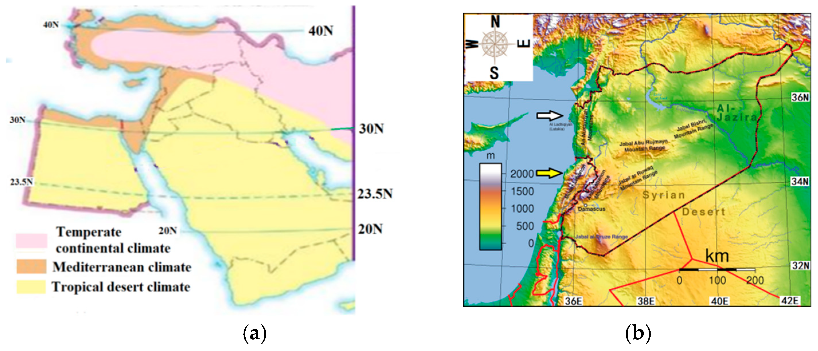
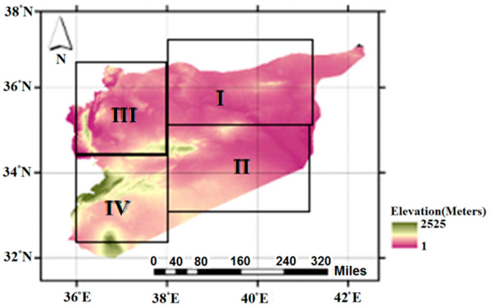
2.1. Study Area
2.2. Numerical Data Sources
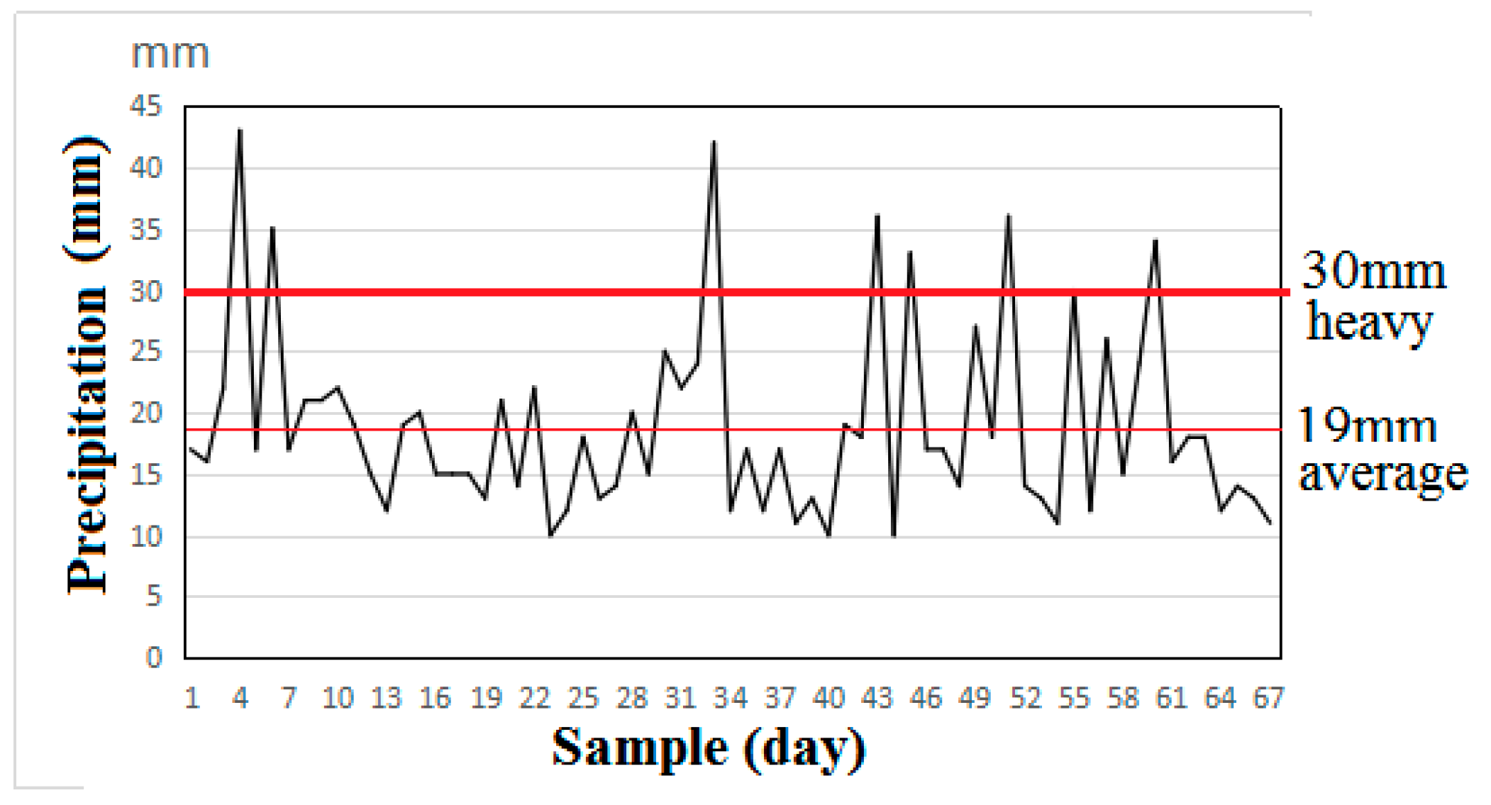
2.2.1. Precipitation Statistic Areas
2.2.2. ECMWF ERA-Interim Data
2.2.3. MODIS Satellite Data
2.2.4. NCEP/CFSR Reanalysis Data
2.3. Methodology
2.3.1. Satellite Data Pre-Processing
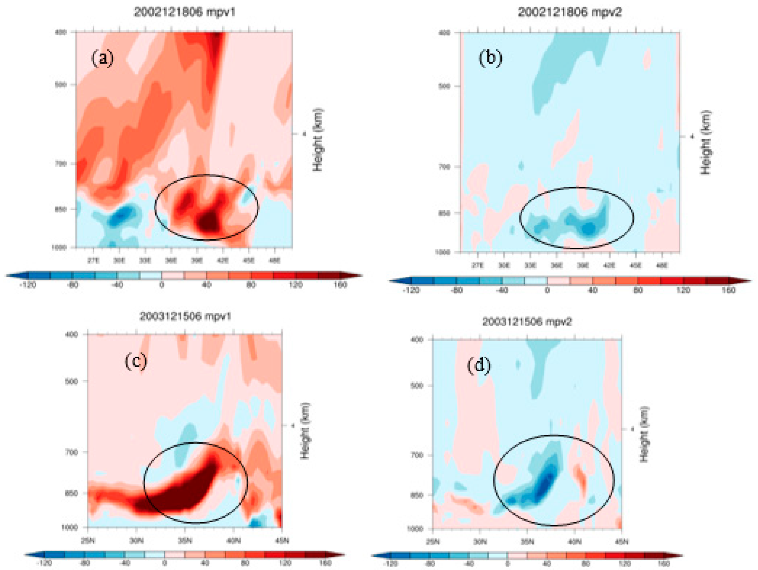
2.3.2. Moist Potential Vorticity (MPV)
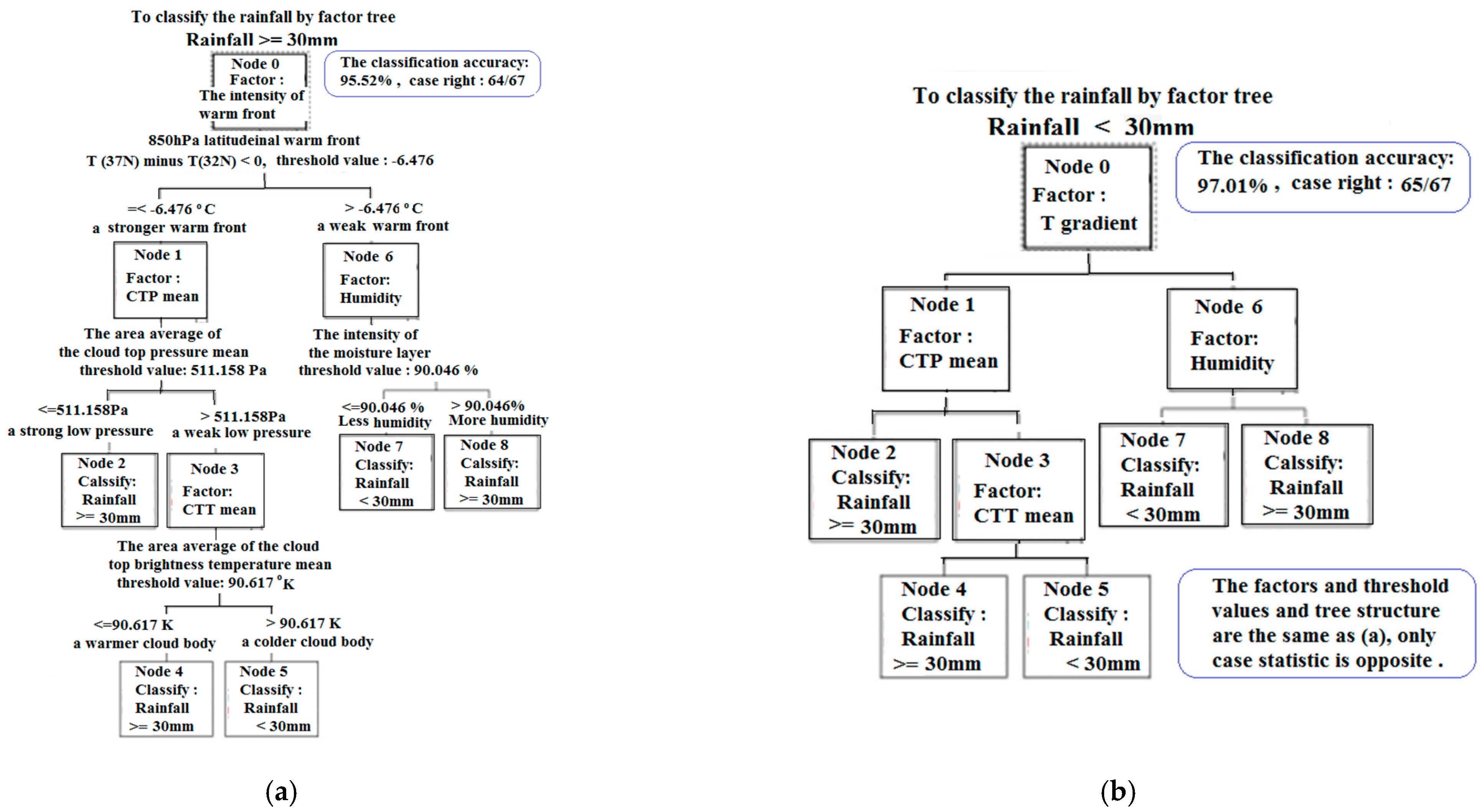
2.3.3. Data Mining C5.0 Decision Tree Algorithms
3. Results
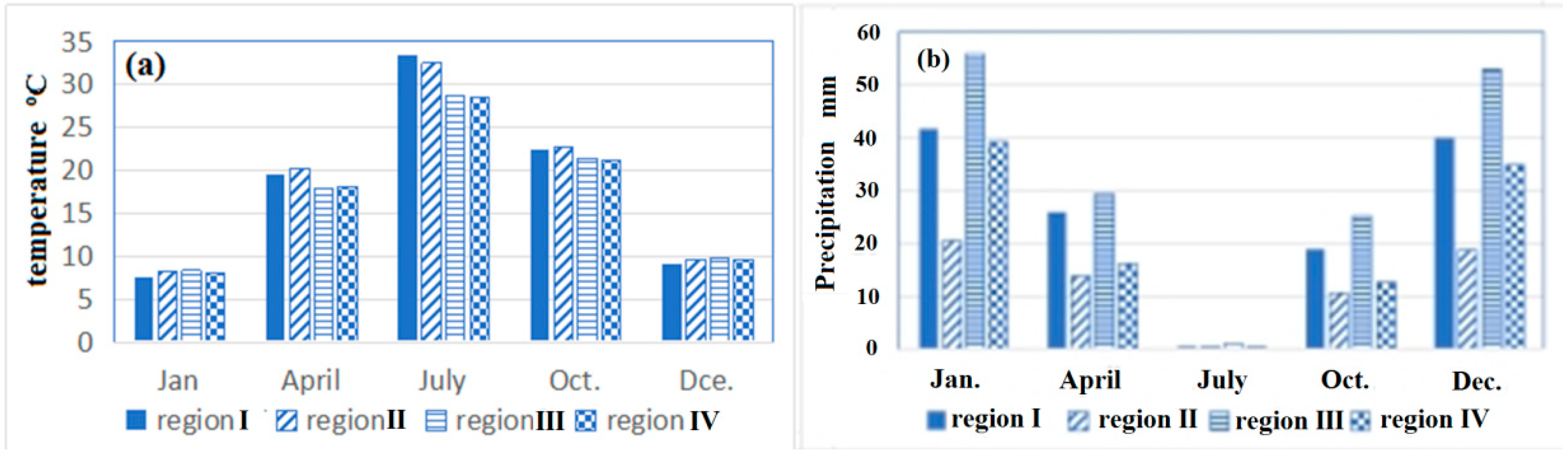
3.1. Local Climate Characteristics and Precipitation Distribution
3.2. Main Systems of Winter Precipitation and Characteristic Information of Local Cloud
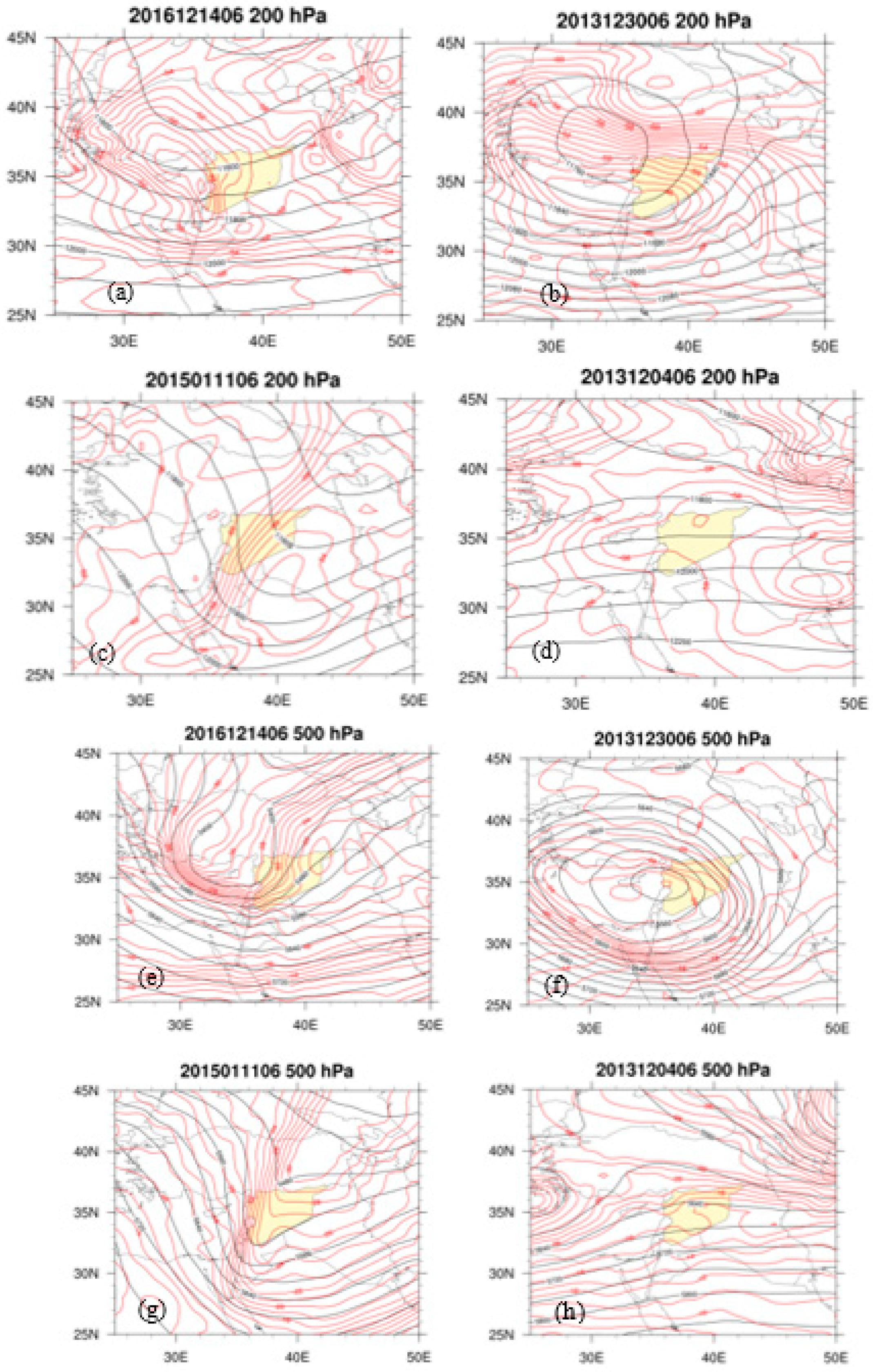
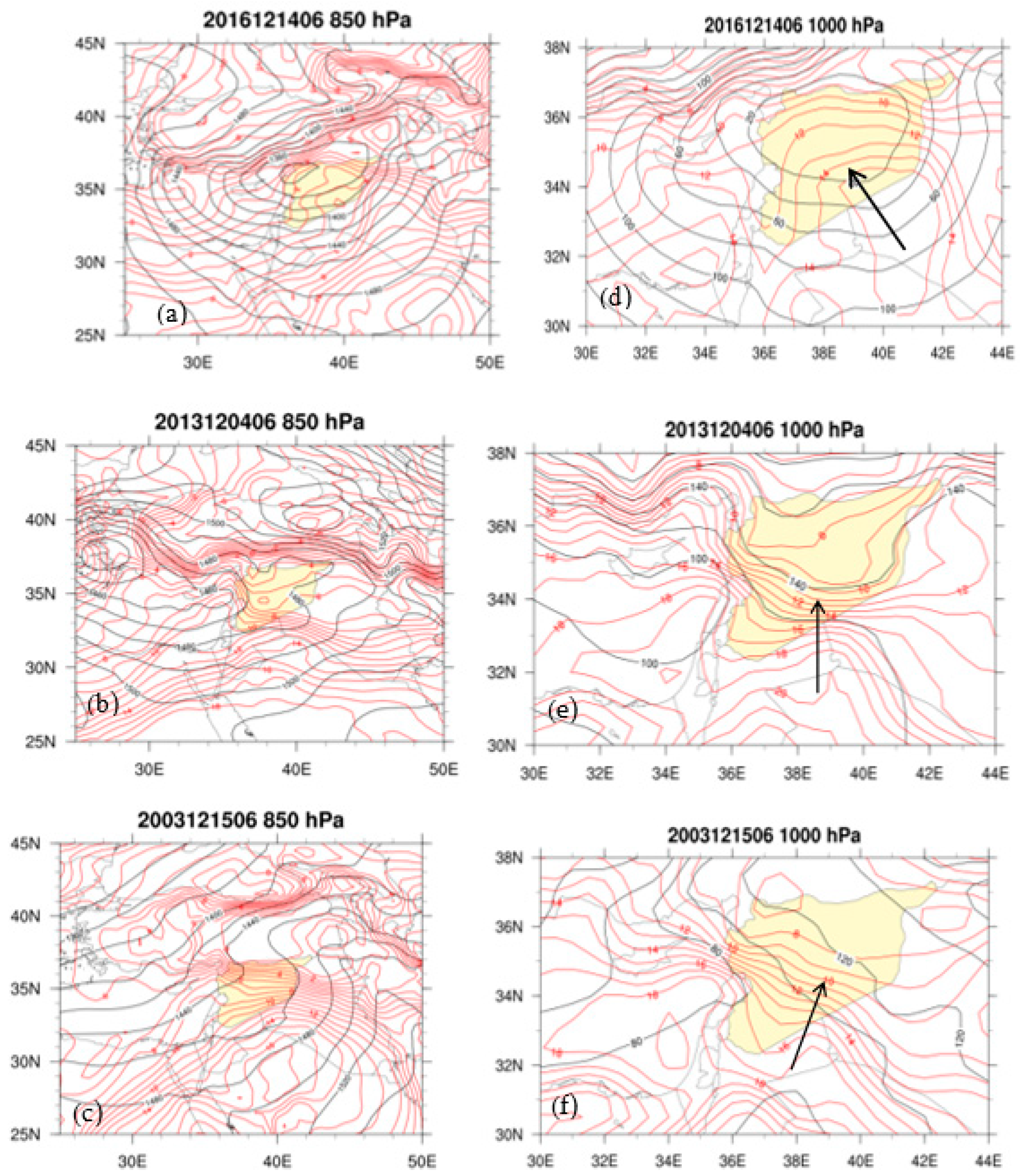
3.2.1. Main Circulation Systems and Dry Warm Front Cyclone
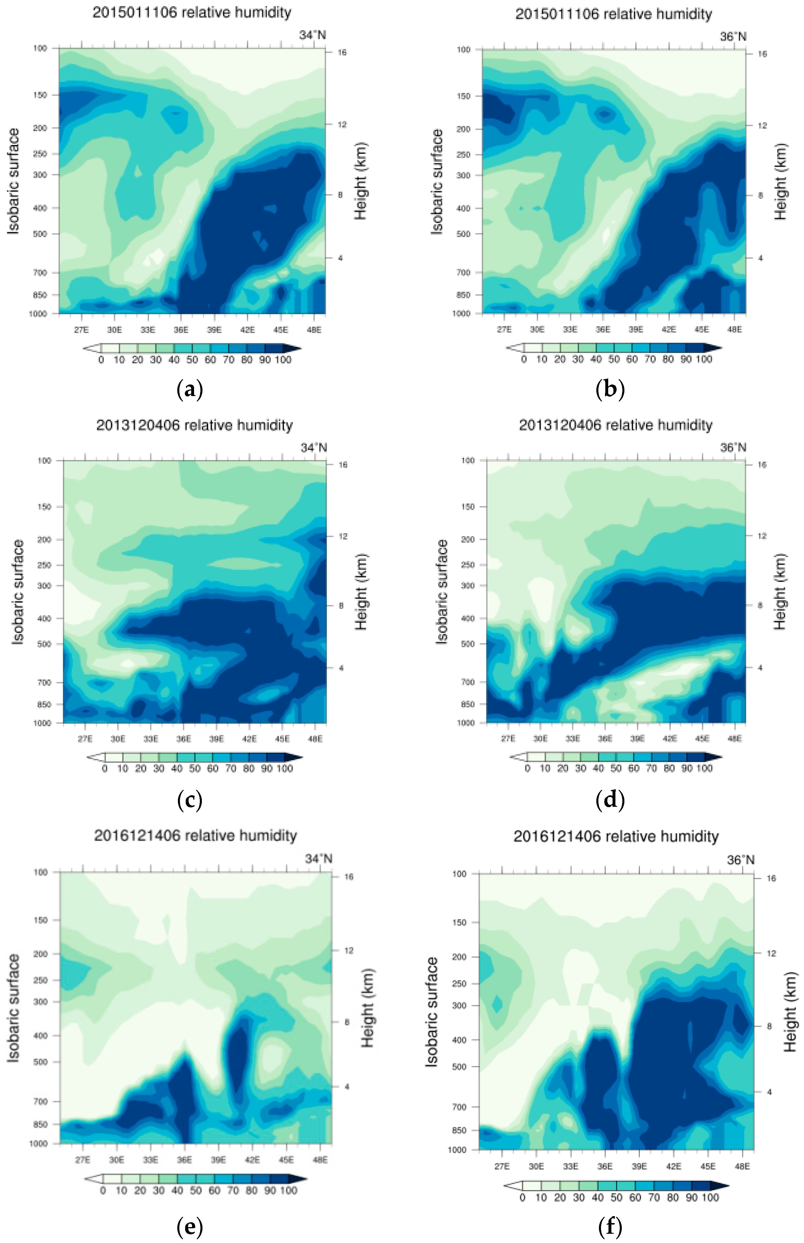
3.2.2. Water Vapor Conditions during the Winter Regional Precipitation
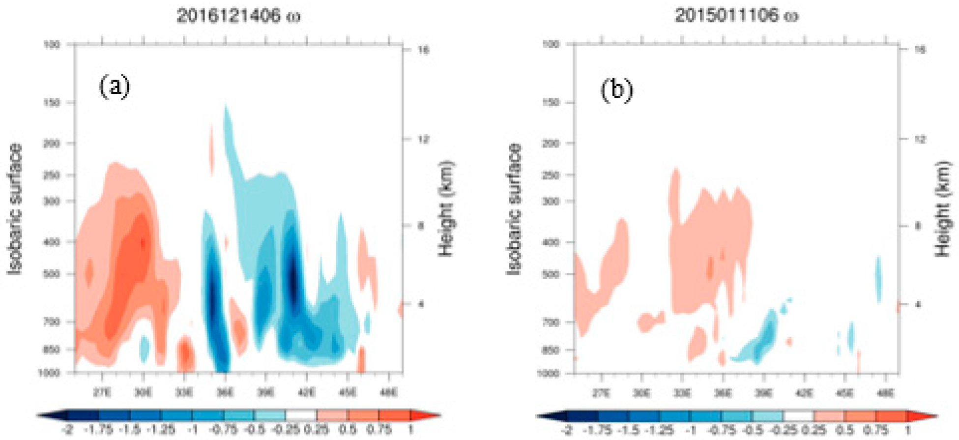
3.2.3. Local Convective Characteristics of Precipitation in Winter
3.2.4. Local Instability Characteristics
3.2.5. Convective Cloud Top Information of Satellite MODIS
3.3. Construction and Application of Data Mining Model
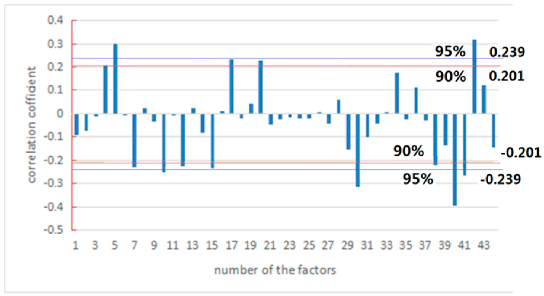
3.3.1. Composition of the Model Factor Dataset
3.3.2. Data Pre-Possessing
3.3.3. Construction Base of a Decision Tree Model
3.3.4. Model Construction and Evaluation
3.3.5. Model Application in Early Warning
4. Discussion and Conclusions
- (1)
- Syria is located at the east end of the Mediterranean Sea. It is an arid country with a rainy season in winter, mainly in December and January. In addition to the Mediterranean climate zones along the Mediterranean coastal areas, the northern interior of Syria also belongs to the Mediterranean climate zone. The mountains on the northern coastline of Syria are narrower and lower than the mountains along the southern coast. The northeast part of Syria is the lowest part of the country. The westerlies bring the Mediterranean moisture over the northern coastal mountain to eastern Syria where the moisture is stored in the low land. The southern coastal mountains connect with desert, causing a tropical desert climate over southern Syria. Thus, the Syrian climate is wet, cold in the north and dry, warm in the south. Moreover, Syrian weather has more precipitation over the north and northeastern interior.
- (2)
- The main characteristics (80–100% of 16 strong rainfall cases) of the key systems during the rainy season in the area are: the dry, warm front cyclonic systems at low and middle levels and the westerly trough at high levels. Further analysis reveals the uniqueness of the structure of such cyclones: the moisture in the north part of the cyclones is higher than that in the south of the cyclone (influenced by the Mediterranean climate zone and the tropical desert climate zone). The humidity in the middle layer is stronger than that in the near-surface (caused by the dry, warm front entering the cyclone). The moisture layer and the vertical ascending motion layer extend vertically up to 200 hPa (affected by active convection in mid-high levels and revealed by the satellite cloud top parameters). Such a regional environmental condition causes the moisture thermodynamic instability (dry, warm air mass at low level and wet, cold air mass at upper level) in the precipitation area. The dry, warm front cyclones provide more dynamic power and instability energy to the precipitation area instead of water vapor. The features are different from that of the common mid-latitude warm front cyclones. The common mid-latitude warm front cyclone is wet in the south and dry in the north, wet at the surface and dry in the upper level, and a warm front usually transmits the abundant moisture to the precipitation area. Especially, the moisture in the dry, warm front cyclone depends on the vapor storage in the low plains of the Mediterranean climate zone, as the northern flow of cyclone is from the plateau to the Mediterranean Sea. It causes a 30 mm rainfall, considered strong precipitation in the arid area, without which enough moisture would not be transported into the area during cyclonic precipitation.
- (3)
- The cloud top information of the MODIS satellite directly reflects the top-level structure and state of the cloud body. However, cloud coverage does not necessarily guarantee precipitation. Therefore, a combination of satellite parameters with the basic characteristics of circulation in the corresponding period is designed, which will improve the effectiveness of the satellite parameter’s application. The cloud-top parameters can indirectly reflect vertical motion characteristics within the cloud body. The advantage of satellite remote sensing is to capture the texture of the convective cloud body and present local cumulus convection characteristics. Therefore, adding the satellite cloud-top parameters and their gradients into the index construction can provide better supplement and improvement to local precipitation information. It is helpful to the areas lacking ground monitoring station data.
- (4)
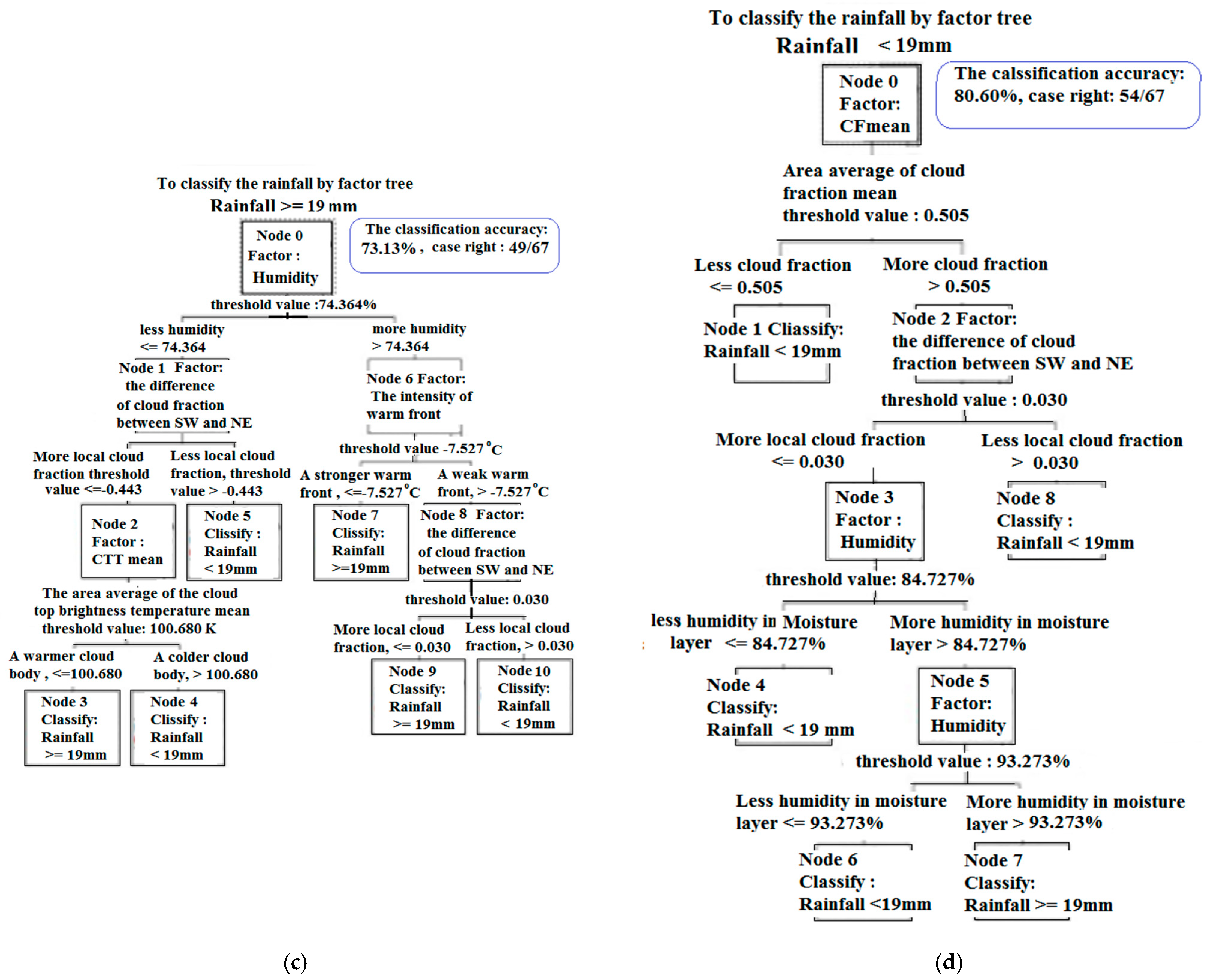
- The decision tree method of data mining is used to build the factor index datasets based on system circulations and satellite cloud parameters. On this basis, precipitation prediction models are constructed, and the models and their prediction effectiveness are evaluated. The decision tree model does not predict specific values of a precipitation event. Instead, it classifies the intensity precipitation through a series of rules (branches and nodes in decision trees) and to make proactive warnings. It is noticed that the model can select the tree node factor and branch rules by objective intelligent training and testing processes. It is suitable to apply to regions lacking effective and systematic near-ground meteorological networks and data. The model has a classification training accuracy reaching up to 98.21% and a 90.91% classification prediction accuracy for ≥30 mm strong rainfall. However, for ≥19 mm of precipitation, the model has a 81.36% classification training accuracy and a 62.5% classification prediction accuracy. The sharp drop in accuracy should be related to the unclear target variable (>19 mm rainfall), which includes strong and moderate precipitations, and the model mixes the nodes and branches with remarkable differences in one decision tree. The model can be applied to other places or larger areas according to the statistic locations and area sizes of precipitation, and it can provide a good reference for predicting results to other numerical forecast models.
Author Contributions
Funding
Acknowledgments
Conflicts of Interest
Appendix A
Appendix B
C5.0 Method Application
References
- Wallace, J.M.; Hobbs, P.V. Atmospheric Science: An Introductory Survey, 2nd ed.; Helé, J., Ed.; University of Washington: Washington, DC, USA, 2006; ISBN 0-12-732951-X. [Google Scholar]
- Feng, S.Z.; Li, F.Q.; Li, S.J. Introduction to Marine Science, 1st ed.; Li, Y.Q., Ed.; Higher Education Press: Beijing, China, 1999; ISBN 704007267. (In Chinese) [Google Scholar]
- Alkhalaf, I.; Solakova, T.; Zelenakova, M.; Gargar, I. Recent climate change in Syria: Seasonal rainfall and climatology of Syria for 1991–2009. Sel. Sci. Pap.-J. Civ. Eng. 2018, 13, 77–96. [Google Scholar] [CrossRef] [Green Version]
- Zakhem, B.A.; Kattaa, B. Investigation of hydrological drought using cumulative standardized precipitation index (SPI 30) in the eastern Mediterranean region (Damascus, Syria). J. Earth Syst. Sci. 2016, 125, 969–984. [Google Scholar] [CrossRef] [Green Version]
- Al Charideh, A.R.; Zakhem, B.A. Distribution dutritiumet desisotopes stables dansles précipitations en Syrie. Hydrol. Sci. J. 2010, 55, 832–843. [Google Scholar] [CrossRef]
- Keatinge, J.D.H.; Dennett, M.D.; Rodgers, J. The influence of precipitation regime on the crop management of dry areas in Northern Syria. Field Crop. Res. 1985, 104, 281–287. [Google Scholar] [CrossRef]
- Thomson, E.F.; Gruner, L.; Bahhady, F.; Orita, G.; Termanini, A.; Ferdawi, A.K.; Hreitani, H. Effects of gastro-intestinal and lungworm nematode infections on ewe productivity in farm flocks under variable rainfall conditions in Syria. Livest. Prod. Sci. 2000, 63, 65–75. [Google Scholar] [CrossRef]
- Karam, A.; Safwan, M.; Ali, M.; Mohammed, S.; He, H. Fine-resolution precipitation mapping over Syria using local regression and spatial interpolation. Atmos. Res. 2021, 256, 16. [Google Scholar] [CrossRef]
- Bilal, A.; Ammar, O. Rainfall water management using satellite imagery—Example from Syria. Int. J. Remote Sens. 2002, 23, 207–219. [Google Scholar] [CrossRef]
- Bilal, A. An Advanced Remote Sensing Mapping Technique Aimed at a Better Rainfall Water Preservation in Syria. J. Earth Sci. Eng. 2013, 3, 613–620. [Google Scholar]
- Duong, H.T.; Sorooshian, A.; Feingold, G. Investigating potential biases in observed and modeled metrics of aerosol-cloud-precipitation interaction. Atmos. Chem. Phys. 2011, 11, 4027–4037. [Google Scholar] [CrossRef] [Green Version]
- Cheng, F.; Zhang, J.; He, J.; Zha, Y.; Li, Q.; Li, Y. Analysis of aerosol-cloud-precipitation interactions based on MODIS data. Adv. Space Res. 2017, 59, 63–73. [Google Scholar] [CrossRef]
- Platnick, S.; King, M.D.; Ackerman, S.A.; Menzel, W.P.; Baum, B.A.; Riedi, J.C.; Frey, R.A. The MODIS cloud products: Algorithms and examples from Terra. IEEE Trans. Geosci. Remote Sens. 2003, 41, 459–472. [Google Scholar] [CrossRef] [Green Version]
- Miao, C.; He, D.; Wang, J.; Shi, D. Research and application of summer rainfall prediction model in the middle and lower reaches of the Yangtze River based on C4.5 algorithm. J. Meteorol. Soc. 2017, 37, 256–264. (In Chinese) [Google Scholar] [CrossRef]
- Zhang, W.; Gao, S.; Chen, B.; Cao, K. The application of decision tree to intensity change classification of tropical cyclones in western North Pacific. Geophys. Res. Lett. 2013, 40, 1883–1887. [Google Scholar] [CrossRef]
- Hertig, E.; Seubert, S.; Jacobeit, J.; Paxian, A.; Vogt, G.; Paeth, H. Statistical and dynamical downscaling assessments of precipitation extremes in the Mediterranean area. Meteorol. Z. 2012, 21, 61–77. [Google Scholar] [CrossRef]
- Nabavi, S.O.; Haimberger, L.; Abbasi, R.; Samimi, C. Prediction of aerosol optical depth in West Asia using deterministic models and machine learning algorithms. Aeolian Res. 2018, 35, 69–84. [Google Scholar] [CrossRef]
- Mishra, N.; Soni, H.K.; Sharma, S.; Upadhyay, A.K. A comprehensive survey of data mining techniques on time series data for rainfall prediction. J. ICT Res. Appl. 2017, 11, 167–183. [Google Scholar] [CrossRef] [Green Version]
- Bhatkande, S.S.; Hubballi, R.G. Weather Prediction Based on Decision Tree Algorithm Using Data Mining Techniques. Int. J. Adv. Res. Comput. Commun. Eng. 2016, 5, 483–487. [Google Scholar]
- Olaiya, F.; Adeyemo, A.B. Application of Data Mining Techniques in Weather Prediction and Climate Change Studies. Int. J. Inf. Eng. Electron. Bus. 2012, 4, 51–59. [Google Scholar] [CrossRef] [Green Version]
- Talebi, H.; Peeters, L.J.M.; Otto, A.; Delgado, R.T. A Truly Spatial Random Forests Algorithm for Geoscience Data Analysis and Modelling. Math. Geosci. 2021, 53, 1–22. [Google Scholar] [CrossRef]
- Binita, S.; Haroon, S.; Sajjad, A. Impervious Surfaces Mapping at City Scale by Fusion of Radar and Optical Data through a Random Forest Classifier. Remote Sens. 2021, 13, 3040. [Google Scholar] [CrossRef]
- Berrisford, P.; Kållberg, P.; Kobayashi, S.; Dee, D.; Uppala, S.; Simmons, A.J.; Poli, P.; Sato, H. Atmospheric conservation properties in ERA-Interim. Q. J. R. Meteorol. Soc. 2011, 137, 1381–1399. [Google Scholar] [CrossRef]
- Kumar, K.R.; Yin, Y.; Sivakumar, V.; Kang, N.; Yu, X.; Diao, Y.W.; Adesina, A.J.; Reddy, R.R. Aerosol climatology and discrimination of aerosol types retrieved from MODIS, MISR and OMI over Durban (29.88° S, 31.02° E), South Africa. Atmos. Environ. 2015, 117, 9–18. [Google Scholar] [CrossRef]
- Xiong, X.; Wenny, B.; Xie, X.; Salomonson, V.; Barnes, W. Summary of terra and aqua MODIS on-orbit calibration and characterization results. In Proceedings of the 2007 IEEE International Geoscience and Remote Sensing Symposium, Barcelona, Spain, 23–28 July 2007; pp. 4128–4131. [Google Scholar] [CrossRef]
- Zurbenko, I.; Smith, D.; Potrzeba-Macrina, A.; Loneck, B.; Valachovic, E.; Sun, M. High-Resolution Noisy Signal and Image Processing; Cambridge Scholars Publishing: Newcastle upon Tyne, UK, 2021; ISBN 1-5275-6293-X. [Google Scholar]
- Miao, C.; Liu, W.; Wang, J.; Wu, M.; Li, T. Comparison between Two Rainstorm Meso-scale Vortices Circumambulated Respectively From Two Sides of Mountain Dabieshan During Meiyu Season. Plateau Meteorol. 2014, 33, 394–406. (In Chinese) [Google Scholar] [CrossRef]
- Luhunga, P.M.; Djolov, G. Evaluation of the Use of Moist Potential Vorticity and Moist Potential Vorticity Vector in Describing Annual Cycles of Rainfall over Different Regions in Tanzania. Front. Earth Sci. 2017, 5, 7. [Google Scholar] [CrossRef] [Green Version]
- Hardy, S.; Schultz, D.M.; Vaughan, G. The 23–26 September 2012 U.K. floods: Using PV surgery to quantify sensitivity to upper-level forcing. Mon. Weather Rev. 2017, 145, 4055–4079. [Google Scholar] [CrossRef]
- Qian, W.; Du, J.; Shan, X.; Jiang, N. Incorporating the Effects of Moisture into a Dynamical Parameter: Moist Vorticity and Moist Divergence. Weather Forecast. 2015, 30, 1411–1428. [Google Scholar] [CrossRef]
- Chen, L.P.; Sun, Y.J. Comparison of object-oriented remote sensing image classification based on different decision trees in forest area. J. Appl. Ecol. 2018, 29, 3995–4003. (In Chinese) [Google Scholar] [CrossRef]
- Lam, W.; Bacchus, F. Learning Bayesian Belief Networks: An Approach Based on the MDL Principle. Comput. Intell. 1994, 10, 269–293. [Google Scholar] [CrossRef] [Green Version]


| Category of Circulation Features | Representative Proportion of Circulation Features in the 16 Strong Rainfall Day Cases | |||
|---|---|---|---|---|
| Circulation at high level (200–500 hPa) | In front part of the westerly trough 81% | A cyclone 6.3% | Behind a westerly trough 6.3% | A Saddle field 6.3% |
| Circulation at the mid-low level (850 hPa) | Closed cyclone 88% | Low-pressure area 12% | -- | -- |
| Surface level (1000 hPa) | Cyclone with warm front 88% | Low-pressure with warm front 12% | -- | -- |
| Wind field at low level (1000 hPa) | Inland cyclone 87% | Coastal cyclone 6.3% | Convergence line 6.3% | |
| Moisture conditions | Higher humidity in the north Humidity center in the middle level 88% | Higher humidity in the south Humidity center in the middle level 12% | -- | -- |
| Vertical rising motion | Convection is active in the east. Extensive thicker layers 94% | Weak convection in the east 6% | -- | -- |
| Heating | Advection larger than latent heating 63% | Advection similar to latent heating; both weak 18% | Advection similar to latent heating; both negative 18% | -- |
| Correlation | Significance and Coefficient Value of Factors (Statistic Area: within 38.5–41.5° E, 32.5–35.5° N) | ||||||
|---|---|---|---|---|---|---|---|
| 90% confidence level | Difference between east and west of cloud top pressure mean −0.21618 | Difference between SW–NE of cloud fraction 0.20688 | Difference between east and west of cloud top temperatures mean (brightness temperature) −0.23027 | Cloud top pressure means −0.23645 | Difference between east and west of cloud top height mean 0.23403 | Cloud top height mean 0.2180 | 1000 hPa latitude front (warm front): Difference of T (37° N–32° N) −0.22300 |
| 95% confidence level | 850 hPa latitude front (warm front): T (37° N–32° N) −0.31304 | Vertical velocity 38° E–43° E mean 850 hPa + 500 hPa −0.39613 | Cloud fraction mean 0.29734 | Cloud top brightness temperature mean −0.25509 | Vertical velocity 38° E–43° E mean 700 hPa −0.27196 | Relative humidity 38° E–43° E mean 850 hPa + 500 hPa 0.31667 | ------ |
Publisher’s Note: MDPI stays neutral with regard to jurisdictional claims in published maps and institutional affiliations. |
© 2021 by the authors. Licensee MDPI, Basel, Switzerland. This article is an open access article distributed under the terms and conditions of the Creative Commons Attribution (CC BY) license (https://creativecommons.org/licenses/by/4.0/).
Share and Cite
Wang, J.; Alakol, N.; Wang, X.; He, D.; Kumar, K.R.; Miao, C. The Strong Precipitation of the Dry Warm Front Cyclone in Syria and Its Prediction by Data Mining Modeling. Atmosphere 2021, 12, 1667. https://doi.org/10.3390/atmos12121667
Wang J, Alakol N, Wang X, He D, Kumar KR, Miao C. The Strong Precipitation of the Dry Warm Front Cyclone in Syria and Its Prediction by Data Mining Modeling. Atmosphere. 2021; 12(12):1667. https://doi.org/10.3390/atmos12121667
Chicago/Turabian StyleWang, Jianhong, Nour Alakol, Xing Wang, Dongpo He, Kanike Raghavendra Kumar, and Chunsheng Miao. 2021. "The Strong Precipitation of the Dry Warm Front Cyclone in Syria and Its Prediction by Data Mining Modeling" Atmosphere 12, no. 12: 1667. https://doi.org/10.3390/atmos12121667
APA StyleWang, J., Alakol, N., Wang, X., He, D., Kumar, K. R., & Miao, C. (2021). The Strong Precipitation of the Dry Warm Front Cyclone in Syria and Its Prediction by Data Mining Modeling. Atmosphere, 12(12), 1667. https://doi.org/10.3390/atmos12121667