Article

Subsistence Agriculture Productivity and Climate Extreme Events

by
Tásia Moura Cardoso do Vale
1,2,*,
Maria Helena Constantino Spyrides
1,
Lara De Melo Barbosa Andrade
1,
Bergson Guedes Bezerra
1 and
Pollyanne Evangelista da Silva
1
1
Programa de Pós Graduação em Ciências Climáticas, Universidade Federal do Rio Grande do Norte (UFRN), Campus Universitário Lagoa Nova, Natal-RN 59078-970, Brazil
2
Unidade Acadêmica Especializada em Ciências Agrárias, Escola Agrícola de Jundiaí (EAJ/UFRN), Rodovia 160, Distrito de Macaíba-RN 59280-000, Brazil
*
Author to whom correspondence should be addressed.
Atmosphere 2020, 11(12), 1287; https://doi.org/10.3390/atmos11121287
Submission received: 12 November 2020 / Revised: 23 November 2020 / Accepted: 24 November 2020 / Published: 29 November 2020
(This article belongs to the Special Issue Climate Change and Agrometeorological Time Series)

Abstract

:
The occurrence of rainfall extreme events leads to several environmental, social, cultural, and economic consequences, heavily impacting agriculture. The analysis of climate extreme indices at the municipal level is of the uttermost importance to the overall study of climate variability and regional food security. Corn, bean, and cassava are among the most cultivated temporary subsistence crops. Thus, the objective of this study was to analyze the relationship between subsistence agriculture productivity and the behavior of rainfall extreme indices in the Rio Grande do Norte state in the period from 1980 to 2013. We used the dataset provided by Xavier (2016) and the climate extreme indices obtained through the Expert Team on Climate Change Detection and Indices. Crop productivity data were retrieved from the Municipal Agriculture Survey from the Brazilian Institute of Geography and Statistics system. The methodology evaluated the behavior and the relationship between agricultural productivity time series and extreme precipitation indicators. We applied the following statistical techniques: descriptive analysis, time series trend analysis by the Mann-Kendall test, cluster analysis, and analysis of variance to check for equal means between identified groups. Cluster analysis was considered an adequate tool for the comprehension of data spatial distribution, allowing the identification of five homogenous subregions with different precipitation patterns. Rainfall extreme indices allowed the analysis of regional conditions regarding consecutive dry days, annual precipitation in wet days, and heavy rainfall. Trends were identified in these indices and they were significantly correlated with dryland crops productivity, indicating a direct relationship between water availability and regional agroclimatic stress.

1. Introduction

Scientific discussions on global climate variability and its environmental impacts have driven the need to better understand the effects of climate extreme events on food production systems [1,2,3]. Indeed, research and actions towards water security and the environmental pressure caused by climate extreme events should be emphasized [4,5,6].
Periods of drought or heavy rainfall have immediate and long-term consequences for agriculture, leading to socioeconomic impacts due to these climate-related stresses [7,8]. At the regional scale, risk to extreme rainfall events is critical and investments in agriculture are demanded in order to assure sustainable food security in the long term. Thus, several studies reported that adversities caused by climate extreme events significantly impact agriculture production over a given a region [7,9,10].
Future climate scenarios projected by the Panel Climate Chance–IPCC report [11] showed that the increasing trend in the frequency of climate extreme events is a reality and agriculture in developing countries will face further water conflicts because sustainable food security is heavily dependent on natural resources [1]. Changes in climate extreme events such as: fewer cold days, longer heat waves, more frequent heavy rainfall, and drought episodes, severely impact the relationship between man and agriculture [12,13,14].
Subsistence agriculture productivity, which is usually developed under dryland conditions (rainfed agriculture), is directly related to water availability. Dryland farming in regions with irregular rainfall patterns is considered a high-risk activity [15]. In this context, approximately 60.4% of the 31,879.3 km² of the Rio Grande do Norte (RN) state are classified as rural areas [16], featuring environmental, cultural, social, and economic aspects that are determinant in the characterization of its society and territory [17].
Rainfall extreme events in northeast Brazil (NEB) were documented in recent studies [6,18,19,20]. The occurrence of these events is usually associated with the variability of atmospheric circulation patterns. The RN state region is influenced by climate systems and phenomena that modulated the occurrence of dry or wet years in the entire NEB. Among them, it is worth mentioning the variability of sea surface temperature in the Tropical Atlantic and the El Niño Southern Oscillation [21,22], which are usually associated with extended drought periods or heavy rainfall events.
In RN state, temporary and permanent crops are culturally and historically related to local economy and subsistence agriculture, as reported by Alves (2010) [7] and Domingues et al. (2016) [23]. Among those, the most successful crops were corn, beans, and cassava [24]. According to the last agriculture and livestock survey in Brazil, RN state accounted for 62,751 agricultural units, of which 93% (59,010) were classified as subsistence farms [16]. The National Institute for Colonization and Agrarian Reform (INCRA) and the Food and Agriculture Organization (FAO), in 1998–99, carried out a study to characterize subsistence agriculture in Brazil. The criteria used was not the extension of cultivated lands, but producers that used more familiar labor than hired labor, as reported in the manuscript New portrait of Brazilian subsistence agriculture) [25]. It is worth noting that this production modality is usually associated with sustainability, employment and income generation, food security, and local development [26,27].
Irrigation is an alternative agricultural practice adopted to deal with irregular rainfall distribution. However, during most of the time and in most of the region it is unpractical since the dams and reservoirs used to store irrigation water also dependent on the occurrence of rainfall and usually find themselves at low storage capacities. Another concern for irrigation is the high atmospheric demand for water in the region [28], which is likely to further increase due to expected climate change [29].
Given these specificities, in a climate change context, decision makers need in-depth information when designing strategies for climate-dependent sectors such as agriculture [23,30]. Thus, statistical analysis of climate variability and extreme events may contribute to the characterization of present and future behavior of climate variables and their relationship with agriculture in a climate change scenario [10,31]. According to Mainali and Pricope (2018) [32] and Marengo et al. (2016) [33], agricultural vulnerability in the semiarid region of the NEB is characterized by the heterogeneous amount and distribution of rainfall, high temperatures throughout the year, low temperature range, strong insolation, and high evaporation rates.
The objective of this study is to analyze the relationship between productivity of the main subsistence crops (corn, bean, and cassava) and the behavior of rainfall extreme events indices for the RN state in the period between 1980 and 2013. Thus, the present study aims to identify groups of municipalities in the RN state that are similar regarding the incidence of climate extreme events, verifying the behavior and trends in productivity of the main subsistence crops in each group.

2. Material and Methods
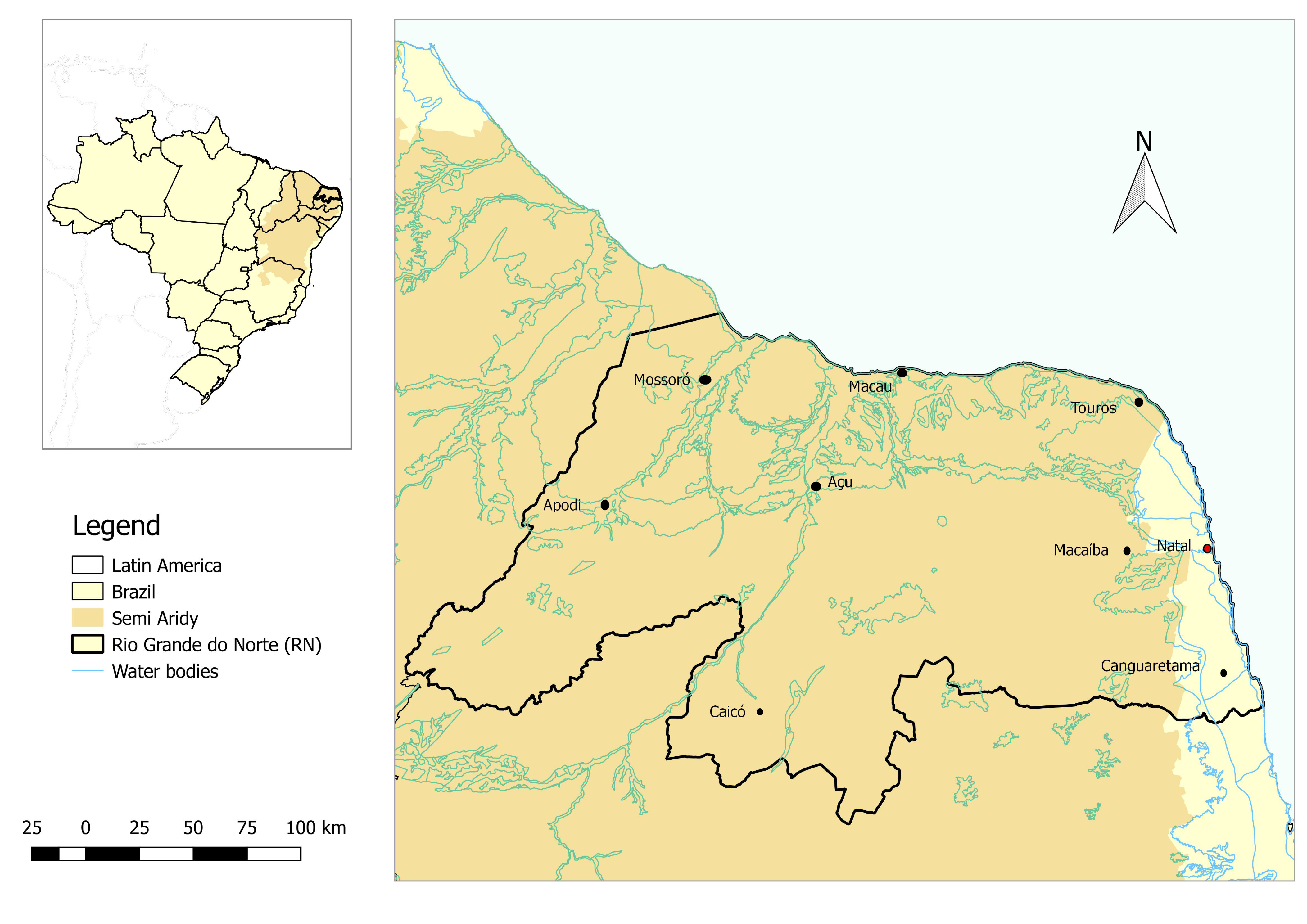
2.1. Study Area

The study area is RN state, located in NEB (Figure 1). RN state is under the influence of two different climate types according to Köppen’s classification [34]: type As, tropical zone with dry summer (eastern coast, southwestern mountainous regions and part of the Chapada do Apodi, in the northwestern portion); and type Bsh, low altitude low latitude semiarid (central portion). Mean annual rainfall in the eastern coast is higher than 1000 mm, while in the southwestern mountainous regions and the northwestern portion it ranges from 700 to 1000 mm [34]. In the central portion, however, rainfall is lower than 700 mm. Mean annual temperature in the RN is predominantly higher than 24 °C during the entire year [34]. In fact, 93% of the state is located within the semiarid (The Brazilian semiarid boundaries are defined by the Superintendence for the Development of the Northeast (SUDENE) based on semiarid climate conditions, particularly low pluviometry. Criteria include: mean annual rainfall equal to or lower than 800 mm; Thornthwaite’s aridity index equal to or lower than 0.5; daily percentage of water deficit equal to or higher than 60%, considering all days of the year) region, which encompasses the northern coast and the entire central portion of the territory. The main biome in the RN state is the Caatinga (95%) and, in the coast, the Atlantic Forest (5%) [35]. Regarding altitude, the state has mountainous regions with elevation ranging from 580 to 830 m, mostly at its southwestern portion, with predominance of shallow rocky soils with low water retention capacity. Main topography includes river and coastal plains, depressions, coastal cliffs, plateaus, and high plains [17,35].

2.2. Data

2.2.1. Agricultural Data

Agricultural data used in the present study were obtained from official data gathered by the Municipal Agricultural Survey (PAM–Pesquisa Agrícola Municipal) [36] and comprise production, sowed area, and annual yield of corn, bean, and cassava crops. We used information on annual production (kg), harvested area (ha), and mean annual yield (kg/ha) at the municipality level for each of the 34 years beginning in January 1980 and ending in December 2013. The definition of mean yield or productivity used in this study refers to the amount in kilograms produced by hectare of harvested area. This is considered the best agriculture indicator representing crop performance under specific conditions of climate, soil, management, and availability of resources.

Agricultural Requirements

The potential productivity of corn (Zea Mays) depends on several factors: adaptation to climate (tolerance to water stress), plant growth and development cycle (number of days between the vegetative and reproductive stages, comprising sowing until physiological maturation), tolerance to pests and diseases (Spodoptera frugiperda and Helicoverpa zea), quality of maize grain yield (kg/ha), crop density, and others. Maize agricultural cycle in the RN state varies from 120 to 140 days, depending on the type of cultivar [37]. To assure its adequate development without the need to irrigate, mean annual rainfall should vary between 250 mm and 600 mm [37,38,39]. In RN, corn is harvested once a year and the mean production between 1980 and 2013 was of 41.6 tons/year, according to the National Company for Food Supply [40,41].
The main bean (Phaseolus vulgaris) production systems in the RN are: rainfed crops (intercropped with corn, manioc or corn and manioc), riverbank farming, and irrigated crops. Mean annual rainfall should be of 300~400 mm minimum in order to avoid irrigation. This crop can be directly harvested and presents a normal cycle of 75 to 110 days from emergence to physiological maturation [42,43]. Other factors that might also reduce bean productivity are weeds, pests and diseases, crop density, soil acidity, among others. In RN state, average bean production between 1980 and 2013 was approximately 37.0 tons/year [40,41].
Cassava (Manihot esculenta) is an arboreous plant, which grows for several years, reaching up to 5 m in height depending on the variety, soil fertility, and age. Cassava is harvested 12 to 18 months after sowing, preferably at the onset of the wet season. Factors that contribute to a low cassava yield are poor soils with high acidity (zinc and manganese deficiency, also called “chapéu-de-palha” or “amarelão”), low genetic potential of varieties and low tolerance to soil diseases, inefficient weed control, and water stress [44]. Water stress is one of the main limitations for crop development during the first five months, when plants are still developing their tuberous roots. Furthermore, excessive rainfall may cause root rotting, favoring the incidence of diseases (bacterial diseases and witch’s broom) and pests (spider mites, whiteflies, lace bugs). Persistence of intense rainfall for 2 to 3 months usually leads to yield losses of more than 50% [37,44,45]. Brazilian average manioc production is of approximately 15 tons per hectare but might reach 30 tons per year. The RN state produced 444.3 tons/year during the period between 1980 and 2013 [16].
Besides rainfall, air temperature is also a primary environmental factor affecting growth, development and yields of crops. Table 1 shows the main cardinal temperatures of the studied crops. One can notice that the temperature in which optimal crop development occurs in ranges from 24 °C (bean) to 30 °C (corn and cassava), while the maximum temperature above which there is no crop reproduction is higher than 32 °C for bean and 35 °C for corn and cassava. Based on the climatological air temperature values in the region, the growth, development, and yield of the crops currently face no apparent threat, since mean annual temperature in the Rio Grande do Norte state is predominantly lower than 26 °C, except in the northern coast and the northwestern region, where values range from 28 °C to 30 °C [46,47]. Still according to the INMET (2020) [47], the frequency of days with temperature higher than 35 °C during the wet season is lower than 20%. However, a gradual increase in temperature of 1.5 °C to 2.5 °C in the region is projected for the period between 2041 and 2070 [29]. Thus, it is possible that the growth, development, and yield of these crops might be impacted in the Rio Grande do Norte state, hampering their cultivation. This is a relevant issue that needs to be further addressed in detail in future studies.

2.2.2. Meteorological Data

Rainfall data used in this study originated from a joint project between the Texas University (USA) and the Federal University of Espírito Santo (Brazil). Data are freely available at the website: https://utexas.box.com/Xavier-etal-IJOC-DATA. The methodology used to obtain this dataset was fully described in Xavier et al. (2016) [49]. Data on the following meteorological variables are available: precipitation, wind, minimum and maximum temperature, relative humidity of the air, and potential evapotranspiration. They refer to interpolated data using the inverse distance weighting method and submitted to cross-validation. Furthermore, they are disposed in a regular grid of 0.25° × 0.25° comprising the entire Brazilian territory.
In this research we used rainfall data over the Rio Grande do Norte state. Daily data were retrieved for the period from 1 January 1980 until 31 December 2013. The studies by Da Silva et al. (2019) [6] and Silveira Marinho et al. (2020) [50] were previously developed in the region using the same dataset. We used information from 167 grid points corresponding to the geographical centroid of each municipal unit in the RN state. We opted for this approach since more than 90% of the municipalities have centroids which are separated by less than 25 km. Furthermore, other studies in the Rio Grande do Norte state previously reported a consistent homogeneity regarding annual rainfall distribution in the studied region [6,51].
The climate extreme indices derived by the Expert Team on Climate Change Detection Monitoring and Indices (ETCCDMI) comprise 11 rainfall indices. In the present study, we selected three of these indicators (Table 2) that represent rainfall deficit and excess in the region. These three indices are: consecutive dry days (CDD), very wet days (R95p), and annual total wet-day precipitation (PRCPTOT). These are considered factors that can potentially reduce crop yield, as previously reported by Huang et al. (2018) [52] in a regional scale study on the decrease of rice productivity due to an increase in the R95p extreme index.
In a study in South America, Skansi et al. (2013) reported significant increasing trends in the occurrence of intense rainfall (R95p) and significant decreasing trends in the number of consecutive dry days in northeast Brazil. This pattern is much more evident when considering temperature indices, since rainfall presents a remarkable temporal and spatial variability in the region. RN state is influenced by both drought and flooding events [6,18], and therefore climate extreme indices aid in the monitoring and detection of changes in climate and in the occurrence of such events, which will probably impact agriculture production. According to Wilcox et al. (2016) [53], in a review of 83 case studies, agriculture production is more sensitive to excessive rainfall than to drought, especially in dry ecosystems. Water stress strongly affects crop yield during different phenological stages of the plant [54]. Thus, the indices selected in this study were the ones that best corresponded to the characterization of RN state regarding homogeneous rainfall extreme events occurrence.

2.3. Methods

Different statistical techniques were used in order to better understand how subsistence agriculture productivity is exposed to climate variability and extreme events.
a)
Cluster analysis
In order to subdivide the RN state in homogeneous regions, we used cluster analysis [55] to classify each municipality according to rainfall extreme indices. Subsequently, subsistence agriculture productivity in each subregion was related to rainfall extreme events, which usually lead to prompt negative effects on agriculture [3,20,52,53].
Two RClimdex indices that characterize consecutive dry days and excessive rainfall were used: CDD and R95p. Thus, cluster analysis allowed the identification of municipalities with similar characteristics regarding the CDD and R95p extreme indices. The mean Euclidean distance dissimilarity measure was used to define the position of each municipality in each created subregion. Ward’s hierarchical method was used between clusters, measuring the increase in the error sum of squares [56].
b)
Trend analysis
The Mann-Kendall test was used to detect trends in climate extreme indices and agriculture productivity time series and is recommended by the World Meteorological Organisation [56]. The Mann-Kendall test is non-parametric [57], and therefore data are not supposed to meet the normality assumption. Sen’s slope estimator (τ) was applied to estimate the intensity of the trends. The main strength of the Sen slope estimator is its robustness in terms of sensitivity to the presence of outliers [58]. The mk.test command from the ‘TREND’ package of the R software (v 3.5.0) was used [59].
c)
Classification of years based on annual rainfall
Each year was characterized through rainfall confidence intervals, namely: wet, normal, dry; according to confidence intervals of mean rainfall over the RN state ( x ¯ = 884.5; s = 219.5). Dry years presented annual rainfall below 665 mm; normal years presented annual rainfall between 665 and 1104 mm; and wet years presented annual rainfall above 1104 mm.
d)
Pearson’s correlation analysis
The Pearson correlation coefficient [60,61] was computed in order to describe the degree of association between productivity and rainfall extreme indices [14]. This association can be positive (if both variables increase in the same direction) or negative (if both variables increase in opposite directions). Since it refers to an observational study, the occurrence of correlation does not necessarily imply causality. The causal effect can only be confirmed in experimental studies in which the effect of other factors that may affect crop productivity can be controlled, such as: temperature stress, diseases, poor soil nutrients availability, and poor crop management practices. In the R software, this calculation was carried out through the cor. test function.
e)
Classification of productivity based on quartiles
Productivity was categorized by using quartiles [62]. Corn, bean, and cassava productivity were presented in maps, by quartile, in order to better describe agriculture yield in RN state.
f)
Analysis of variance (ANOVA)
We used analysis of variance [57,63,64] to compare the means of each of the five subregions defined with cluster analysis in order to identify differences in mean productivity between groups. Subsequently, Tukey’s test for multiple comparisons was used in order to identify significant differences between agriculture productivity in the defined clusters. The results of the Tukey test are presented as letters in which groups with different letters (A, B, C…) have statistically significant differences at the 5% level, while groups with similar letters are statistically equal. When necessary, outliers were excluded from the analysis. In the R software [62], we used the lm function for the ANOVA and the TukeyHSD function for the calculation of the Tukey test.

3. Results

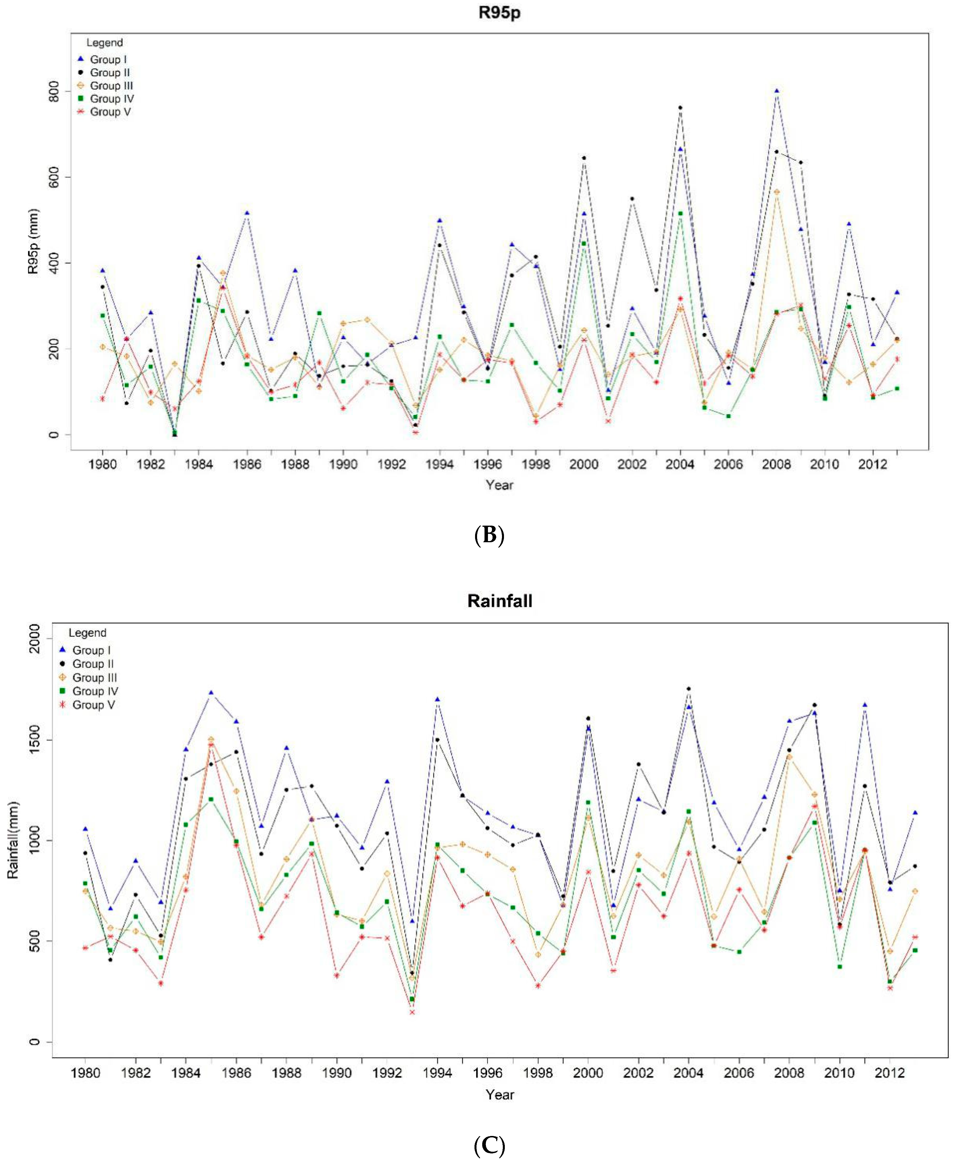
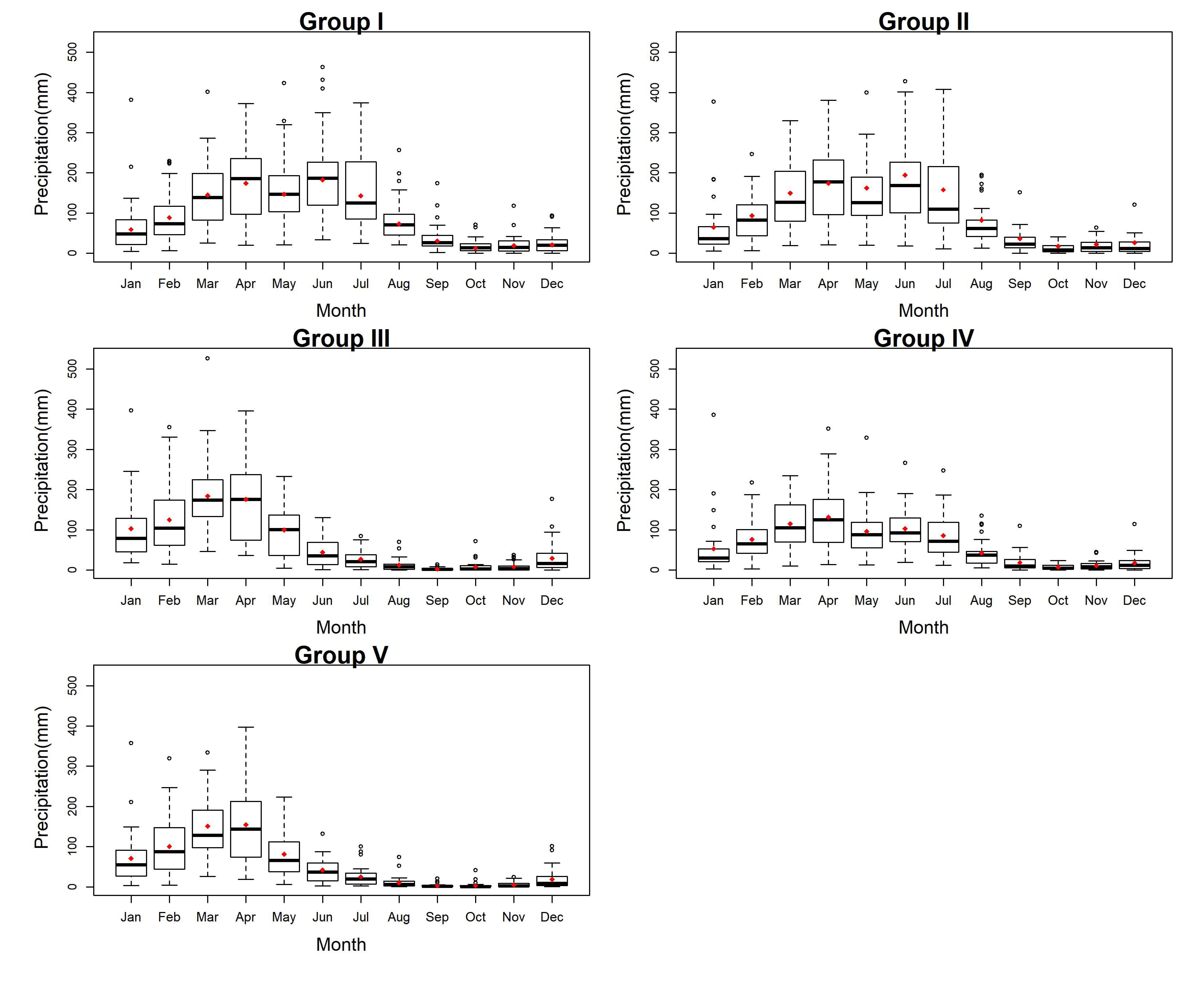
3.1. Municipal Classification Regarding Rainfall Extreme Events

Results obtained with cluster analysis revealed five homogeneous groups named I to V (Figure 2) that presented descriptive statistics and trends in climate extreme indices as shown in Table 2.
Group I was characterized by the lowest amount of consecutive dry days with rainfall below 1 mm (35 days/year), while 5% of the rainfall registers exceed 313.8 mm. This group encompassed 24 municipal units in the southern coast of the state (Figure 2) and comprises the wettest municipalities in RN with no significant trend in climate extreme indices (Table 3).
Group II presents an annual average of 40.3 consecutive dry days and 5% of the registers exceed 287.6 mm with a significant increasing trend. The average behavior was statistically similar to Group I. This group encompassed 19 municipalities located in the northern coast of RN and is the second wettest region of the state (Table 3).
Group III presented the second largest average number of consecutive dry days with precipitation below 1 mm, corresponding to 79.6 days/year, and being statistically similar to Group V. However, 5% of the rainfall registers exceeded 190.1 mm. This region comprised 19 municipal units in the southwestern portion of the RN state (Table 3).
Group IV presented 60 consecutive dry days on average, with an increasing trend. Regarding rainfall, 5% of registered values exceeded 179.8 mm, which was one of the lowest rates in the state. The behavior of rainfall extreme indices was statistically similar to groups III and V. This group comprised 32 municipal units located inland of the two aforementioned coastal regions (I and II), as shown in Figure 2.
Group V was characterized as the most arid region of the state, with the highest amount of consecutive dry days–95.1 days/year on average–and the lowest 95th percentile of accumulated rainfall: 150.9 mm. Despite registering the lowest rainfall extremes, an increasing trend was identified between 1980 and 2013, with a minimum R95p of 125.9 mm and a maximum of 178.6 mm. It comprised 73 municipal units located in the central-western portions of the state, mostly situated in the semiarid region of Brazil (Table 3).
Trend analysis for the CDD index indicated a significant increase only in Group IV (τ = 0,266 and p-value = 0,028) for the period between 1980 and 2013 (Table 3). On the other hand, statistically significant positive trends for the R95p index were found in Groups II (τ = 0,251 and p-value = 0,038) and V (τ = 0,198 and p-value = 0,093) (Figure 3A,B).
The year 1983 and 1993 stood out with the lowest accumulated rainfall and R95p values (485.6 mm and 323.9 mm, respectively). It is also worth mentioning that rainfall decreased in all groups since 1985 (1458.1 mm), an anomalously wet year, until the 1993 drought. The same behavior can also be observed after the wet year 1994 (1211.2 mm) until 1999 (593.9 mm). In these two periods, a sharp decrease in accumulated rainfall was observed, which could have affected agriculture in the RN state.
The RN state presents a remarkable interannual variability of rainfall in the different clusters (Figure 3C). Several authors reported the relationship between positive anomalies in events over the Pacific Ocean and the occurrence of severe drought in the NEB region [7,34,63]. In the studied region, the driest years which were probably associated with El Niño anomalies were: 1981–1983 and 1991–1993; while in the years of 1998 and 2010 both El Niño and La Niña anomalies were observed. Regarding wet years, which are usually associated with La Niña anomalies, the most representative years were 1998 and 2010. However, the method used by the CEPTEC/INPE (http://enos.cptec.inpe.br/) classified the occurrence of events as: El Niño (1980, 1981, 1982, 1983, 1986, 1987, 1991, 1992, 1993, 1997, 2002, 2003, 2006, 2007, 2009, and 2010), Mixed (1988, 1998, 2007, and 2010), La Niña (1988, 1989, 1999, 2000, 2008, and 2011), and Neutral (1984, 1985, 1990, 1995–1996, 2001, 2004, 2005, 2012, and 2013). Between the different ENSO phases, La Niña was the event that most positively contributed to the occurrence of rainfall in the clusters of the RN state (Group I: 1318.71 mm, Group II: 1263.38 mm, Group III: 1051.86 mm, Group VI: 896.25 mm, Group V: 818.75 mm). Contrarily, El Niño and mixed El Niño and La Niña events were associated with the lowest rainfall amounts, corroborating with the CPTEC/INPE (2020) bulletin. In years of El Niño, lower rainfall amounts were registered in all regions (Group I: 1058.57, Group II: 948.23 mm, Group III: 770.88 mm, Group IV: 657.79 mm, Group V: 588.89 mm), while even lower values were observed in years of mixed El Niño and La Niña events (Group I: 1112.72 mm, Group II: 979.56 mm, Group III: 673.9 mm, Group IV: 583.46 mm, Group V: 532.14 mm).
Given the importance of climate seasonality for agriculture, we analyzed the seasonal behavior of rainfall and its relationship with subsistence agriculture production (Figure 4). One can notice that rainfall events in Groups I, II, and IV were more sparsely distributed throughout the year while in Groups III and V they were concentrated in four wet months. April was the month with the most variable rainfall in all groups. In Groups I, II, and IV, the wet season began in March and ended in July, which characterized a longer wet period (five months), with accumulated rainfall of 70.9%, 72.3%, and 70.2%, respectively. The wet season in Groups III and V was established between February and May, with amounts accounting for 71.4% and 73.1% of total annual rainfall.

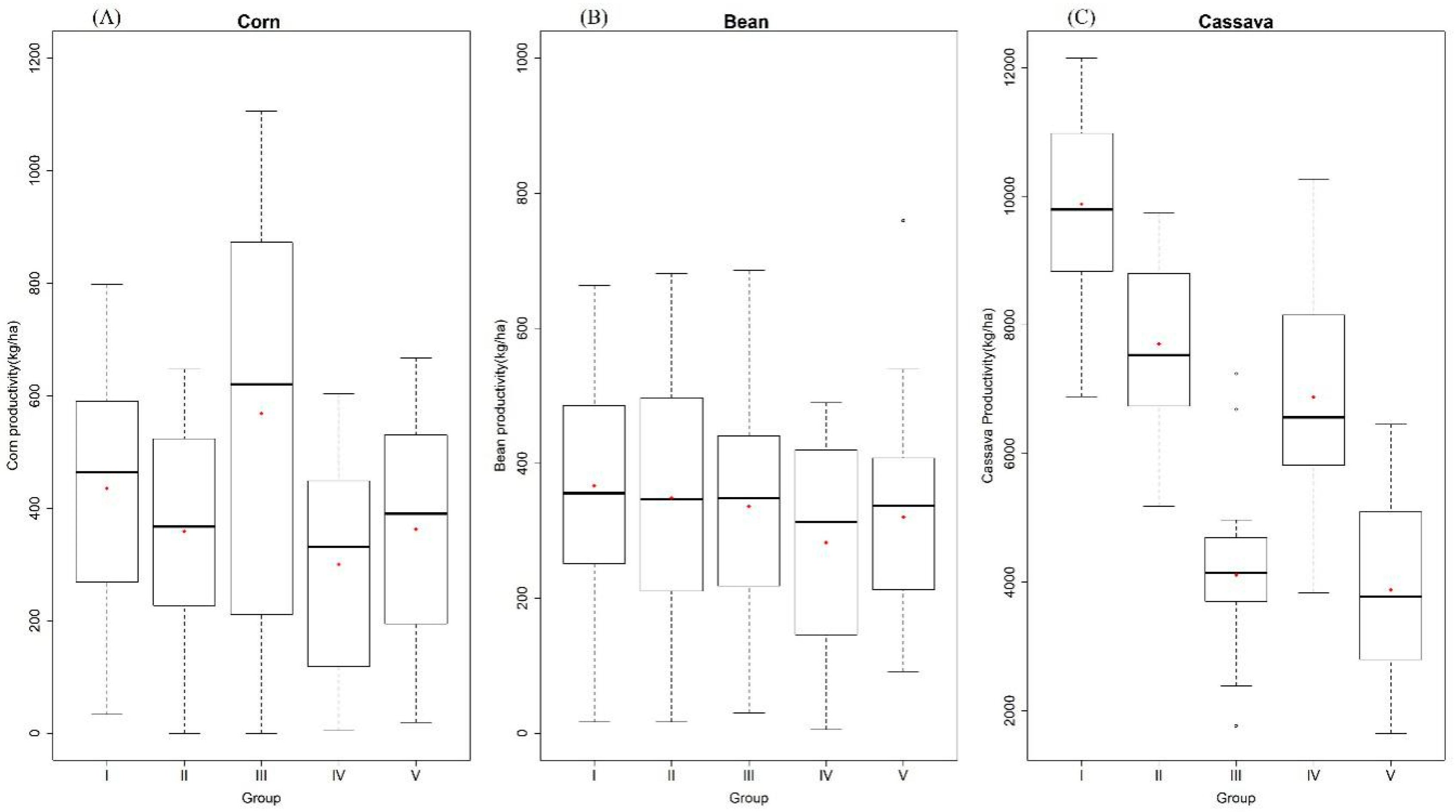
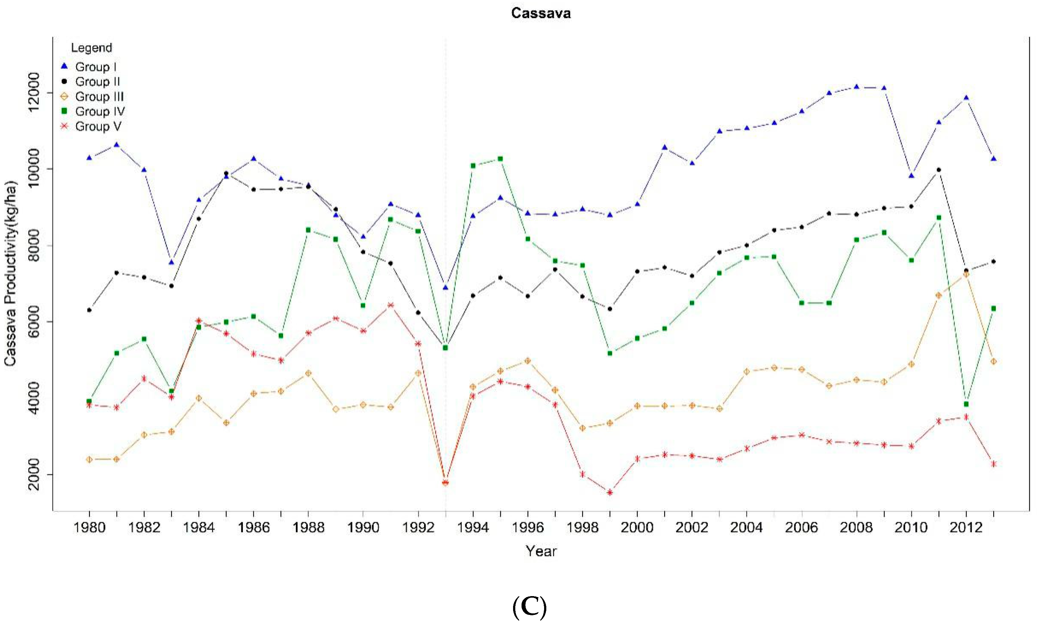
3.2. Subsistence Agriculture Productivity

Mean productivity in RN in the period from January 1980 to December 2013 was: 388.93 kg/ha for corn, 327.95 kg/ha for bean, and 5719.61 kg/ha for cassava. Results (Table 4 and Figure 5) show that corn productivity in Groups III and I–568.8 kg/ha and 435.4 kg/ha, respectively, was higher than in other groups. Although Group III presented one of the highest productivities, it varied considerably around the mean (Figure 6). The lowest corn productivity was observed in Groups V and IV. No significant differences (p-value = 0.249) were found for bean productivity between groups (Table 4). Cassava productivity was higher in Group I (Table 4), with an average yield of 9879.7 kg/ha significantly differing from other groups; followed by Groups II and IV. The least productive groups were III and V, which correspond to the westernmost regions of the RN state.
By analyzing the historical series of crop productivity (Figure 6) in the period from 1980 to 2013 according to each cluster, one can notice an increasing trend in corn productivity for Group I (τ = 0.611; p-value < 0.001) and Group II (τ = 0.308; p-value = 0.010) (Figure 6A). Regarding bean productivity, increasing trends were identified for Group I (τ = 0.615; p-value < 0.001), II (τ = 0.418; p-value < 0.001), and V (τ = 0.226; p-value = 0.061) (Figure 6B). Finally, significant negative trends were found in cassava productivity for Group I (τ = − 0.222; p-value = 0.066) and V (τ = − 0.361; p-value = 0.002), while positive trends were found for Group III (τ = 0.516; p-value = 0.019) and IV (τ = 0.229; p-value = 0.057) (Figure 6C).
The dry year 1993 and the wet year 2000 represented rupture points in the productivity time series (Figure 3C). The years 1983, 1993, and 2012 presented the highest amount of consecutive dry days and the lowest accumulated rainfall. Productivity recovers in 1994, followed by another decline lasting until 1999, as well as from 2008 until 2012 in some groups. This confirmed that the decline in rainfall series observed between the years 1994 and 1999 indeed affected subsistence agriculture in the RN state.
After the critical drought of 1993, productivity in some groups seems to recover, such as corn in Group I (τ = 0.499 and p-value = 0.043) between 1994 and 2011, and in Group II between 2000 and 2011, while productivity of other crops presented significant decreasing trends. Since Groups I and II comprise wetter regions, producers probably managed to maintain increasing yields. Cassava productivity also increased between 1994 and 2009 in Groups I and II, while for the other groups yield increased between 2000 and 2011.
A positive correlation was found between rainfall and corn, bean, and cassava productivity (Table 5), indicating that the higher the annual accumulated rainfall, the higher the crop productivity. Correlation with the R95p index was significant only for bean and cassava. No significant correlation was found between the CDD index and the analyzed crops.
In all groups, both the R95p index and accumulated rainfall were strongly and positively correlated with corn productivity, indicating that more rainfall leads to higher yields. In the case of bean, the same behavior was observed except for Group III, where no statistical significance was found for correlation with the R95p index at the 5% level. Cassava productivity was positively correlated with total precipitation (PRCPTOT) only for Groups II and IV, and with R95p for Group III.
Years were classified as wet, normal, and dry in order to determine how productivity is affected by the occurrence of dry or wet conditions. Therefore, nine dry years, 17 normal years, and eight wet years were identified in the time series (Table 6).
Overall, according to subSection 2.3, point-c, mean productivity in dry years was significantly different from normal and wet years in all groups and for all crops, except cassava in Groups I, III, and V. Bean productivity presented statistically significant differences between wet and dry years, but no difference was found between normal years and dry or wet years in Groups I and II. According to yield quartiles, the maps in Figure 7 show the spatial distribution of crop productivity in the RN state at the municipal level. Southern (Group I) and western (Group III) municipalities present above-median corn productivity (Figure 7A). Bean productivity (Figure 7B) was higher in the southern coast (Group I), northern coast (Group II), and central RN (Group V). Finally, cassava productivity (Figure 7C) was higher in the southern coast (Group I), northern coast (Group II), and their inlands (Group IV).

4. Discussion

Rainfall regime is modulated by the occurrence of atmospheric systems at different scales, which influence the variability of precipitation over a given region. Rainfall extreme events in the NEB were documented in recent studies [6,18,20]. These events are usually associated with the variability of atmospheric circulation patterns. Rainfall over RN state is influenced by climate systems and phenomena that modulate the occurrence of dry or wet years over the entire NEB.
The present study identified five homogeneous groups based on the occurrence of rainfall extreme events in the RN state. In the coastal region encompassed by Groups I and II, land breezes may favor the occurrence of extreme rainfall (R95p), which generally occur at dawn or early morning. In the region encompassed by Groups III, IV, and V, easterly wave disturbances (EWD) associated with sea breezes may propagate over 300 km towards the inlands of RN state [19]. These events usually occur associated with the variability of atmospheric circulation patterns such as the displacement of the ITCZ to a southernmost position, favoring the occurrence of rainfall between March and April over the RN region [65,66,67,68,69]. This shift in the ITCZ position can be explained by the negative dipole in sea surface temperature fields over the Tropical Atlantic (negative anomalies with colder temperatures in the North Atlantic and positive anomalies with warmer temperatures in the South Atlantic).
Results highlighted the need to differentiate municipal characteristics regarding the occurrence of rainfall extreme events in order to assess water-related risk in the RN state. Furthermore, the exposure of agriculture to these climate events might influence productivity depending on the characteristics of the crops. Low subsistence agriculture productivity in the state is related to the particular characteristics of family farming. Exposure to water risk, such as water shortage or excess, can be managed by applying a variety of adaptation strategies regarding the adversities caused by climate extreme events [23,26,27]. In global warming scenarios projected by the IPCC, inter-regional models estimate losses of up to −7.2% to the RN economy considering the A2 scenario and the period between 2010 and 2050 [70].
The lowest mean crop yields (corn, bean, and cassava) in RN state were registered during dry years. Furthermore, the increasing trend in the frequency of occurrence of dry years, driven mostly by the reduction in rainfall amount during transition months, was also identified in several previous studies in the NEB [20,71,72].
The present study shows that the highest mean productivities (good aptitude) of bean and cassava were found in Groups I and II, while corn productivity was higher in Group III. Positive correlations were found between productivity and PRCPTOT and R95p. The ideal conditions for corn sowing took place in February for Group III, and in March for Groups I, II, IV, and V. The region encompassed by Group IV was marked by water shortage, moderate aptitude for corn and bean, and increasing trends in cassava productivity. Sowing in Group V is limited to the months from March to April, marked by severe water scarcity.
Regarding phenological stages, corn crops demand more water during several stages of plant development, with seasonal rainfall preferably above 250 mm according to Cakir (2004) [57]. This author carried out a field experiment in order to determine the effect of irrigation and water stress on productivity by varying rainfall from the beginning of the sowing cycle until flowering and the formation of corn ears. In this sense, mean temperature in the region encompassed by Group III was of 30.1 °C, while rainfall in the months from December to February accounted for 31.4% of total annual precipitation. Group III presented the earliest conditions for reaching field capacity, therefore creating optimal settings for germination and sprouting according to the observed agroclimatic characteristics [37,39]. Results from a seven-year experiment conducted by Silva et al. (2011) [15] in a neighboring state to RN (Alagoinha-PB) indicated that rainfall was the most impactful factor on corn productivity in conventional dryland systems.
Water-use during the vegetative cycle of bean depends on the stage of development, soil type, sowing period, and climate conditions. According to Ribeiro et al. (2011) [40], bean demands more water in the critical moments of germination, flowering, and stalk formation, ranging from 300 to 400 mm in order to obtain high yields. In the RN state, no significant differences were identified in bean productivity between groups. However, crops were more productive in wet and normal years if compared to dry years, with increasing yield trends observed in Groups I, II, and V.
Agricultural aptitude for bean crops in the regions comprised by Groups III and V was observed since the first half of March, while for Groups I, II and IV it was observed in the second half of March. Furthermore, the extended wet period between March and May observed in Groups I, II, and IV favor the adoption of better crop management practices. Climate adversities become more relevant when bean sowing takes place later than the aforementioned periods, increasing the risk of crop failure. Bean productivity was significantly positively correlated with the PRCPTOT and R95p indices. The only exception was the region encompassed by Group III, where bean yields were not correlated with the R95p index, but only PRCPTOT.
Cassava productivity in Groups III and IV presented significant increasing trends, portraying a certain tolerance to consecutive dry days (CDD), which reached values up to 60 days/year, although CDD in Group IV also revealed increasing trends. In this group, 62.54% of the municipalities presented above-median cassava productivity (8638.50 kg/ha). Rainfall characteristics in this region favored sowing beginning early April, with accumulated rainfall above 400 mm [73]. These results indicate the potential use of crop managements practices for water control, since irrigation water restrictions may increase average cassava yield in regions suffering from water scarcity.
Throughout the studied period, groups showed a decrease in productivity between 1994 and 2000. Through an agrometeorological perspective, it is worth mentioning that alterations in climate may negatively affect subsistence agriculture productivity in dry years or even in subsequent years. According to Ray et al. (2015) [74], the influence of interannual climate variability on agriculture worldwide explains one third of overall global agricultural productivity. In these global hotspot regions, such as drylands and steppes, yield gaps were large not due to the lack of water per say, but to inefficient water, soil, and crop management.
Agroecological and management practices maximize biological activity, preserving soil fertility and productivity even with the lack of rainfall. Among these, it is worth mentioning: relocation of wild species, agroforestry systems, polyculture and organic soil management, using rock micro-dams in association with soil cover, and using cactus pear plants in the contour of cultivated areas [26,27].
At the regional scale, the expansion of corn-, bean-, and cassava-cultivated lands is recommended for regions I and II, by using consortiums with high density planting and the use of hybrid seeds in order to boost productivity. Expanding cassava cultivation in regions III, IV, and V is also recommended using irrigation systems to favor water distribution during development stages. Investments in practices that increase the efficiency of dryland systems, favoring infiltration and contributing to the optimization of water-use should also be encouraged.
Dryland farming in RN state is carried out in regions that suffer from rainfall excess or shortage; however, water restrictions are not always associated with the absolute lack of water, but rather to its distribution. Water management is therefore the main strategy to be used in order to overcome dry periods and reduce water risk, mitigating the effects of climate extreme events on subsistence agriculture productivity.

5. Conclusions

Productivity of subsistence agriculture, such as corn, bean, and cassava, in RN state was positively correlated with wet days and extreme rainfall indices, and higher yields were strongly associated with wetter years. These indices were influenced by atmospheric systems characterized by different extreme patterns, which allowed the identification of areas with better or worse agricultural aptitude regarding those crops. Results indicated better conditions for higher corn yields in the western region (Group III) and the northern coast (Group II) of RN state; for higher bean yields in southern and northern coasts (Groups I and II); and for higher cassava yields in the northern and southern coast and their inlands (Group IV). Increasing trends were observed for corn productivity in the southern and northern coasts; for bean productivity in the southern and northern coasts and the central portion of the RN state; and for cassava productivity in the western regions and the inlands of the eastern coast. Regarding seasonality, the following periods were found for optimal water availability: early March until 15th April for the southern and northern coasts; February and March for the western region; and the second half of March and the second-half of April for the central portion and the inlands of the eastern coast.
This study provides crucial information regarding the understanding of seasonality and trends in rainfall extreme events in the RN state. This information can be used as tools by rural producers in order to better plan their crops and increase productivity. Thus, new scientific researches aiming to better explain and understand regional dynamics of atmospheric systems and how they relate to the main local crops is of the uttermost importance for the development of incentive policies that assure the agricultural success of subsistence farming.

Author Contributions

T.M.C.d.V.: Conceptualization, Data curation, Formal analysis, Methodology, Software, Writing—original draft. M.H.C.S.: Supervision, Formal analysis, Methodology, Validation, Writing—Review and Editing. L.D.M.B.A.: Conceptualization, Methodology, Writing—Review and Editing. B.G.B.: Conceptualization, Writing—Review and Editing. And P.E.d.S.: Software and Data curation. All authors have read and agreed to the published version of the manuscript.

Funding

This research received no external funding.

Acknowledgments

We would like to thank the Universidade Federal do Rio Grande do Norte, which provided us with the means and instruments to prepare this article. The authors are also grateful to the Instituto Brasileiro de Geografia e Estatística (IBGE), Instituto Nacional de Meteorologia (INMET) and Centro de Previsões de Tempo e Estudos Climáticos (CEPTEC/INPE). We are also thankful to Alexandre Cândido Xavier for the rainfall data and to the Expert Team on Climate Change Detection and Indices (ETCCDI), which elaborated the extreme indices used in this study. We are thankful to all collaborators that created and disclosed the R software and the RClimdex package.

Conflicts of Interest

The authors declare that they have no known competing financial interests or personal relationships that could have appeared to influence the work reported in this paper.

References

  1. FAO—Food and Agriculture Organization of the United Nations. How Does International Price Volatility Affect Domestic Economies and Food Security? FAO: Rome, Italy, 2011; ISBN 978-92-5-106927-1. Available online: http://www.fao.org/3/a-i2330e.pdf (accessed on 22 June 2020).
  2. Ramirez-Villegas, J.; Challinor, A.J.; Thornton, P.K.; Jarvis, A. Implications of regional improvement in global climate models for agricultural impact research. Environ. Res. Lett. 2013, 8, 024018. [Google Scholar] [CrossRef]
  3. Assad, E.D.; Costa, L.C.; Martins, S.; Calmon, M.; Feltran-Barbieri, R.; Campanili, M.; Executivo, S. Papel do Plano ABC e do PLANAVEG na Adaptação da Agricultura e da Pecuária às Mudanças Climáticas. WRI Brasil, São Paulo. Available online: https://wribrasil.org.br/pt/publicacoes (accessed on 22 June 2020).
  4. Skansi, M.D.L.M.; Brunet, M.; Sigró, J.; Aguilar, E.; Groening, J.A.A.; Bentancur, O.J.; Geier, Y.R.C.; Amaya, R.L.C.; Jácome, H.; Ramos, A.M.; et al. Warming and wetting signals emerging from analysis of changes in climate extreme indices over South America. Glob. Planet. Chang. 2013, 100, 295–307. [Google Scholar] [CrossRef]
  5. Myers, S.S.; Smith, M.R.; Guth, S.; Golden, C.D.; Vaitla, B.; Mueller, N.D.; Dangour, A.D.; Huybers, P. Climate Change and Global Food Systems: Potential Impacts on Food Security and Undernutrition. Annu. Rev. Public Heal. 2017, 38, 259–277. [Google Scholar] [CrossRef]
  6. Da Silva, P.E.; E Silva, C.M.S.; Spyrides, M.H.C.; Andrade, L.D.M.B. Precipitation and air temperature extremes in the Amazon and northeast Brazil. Int. J. Clim. 2019, 39, 579–595. [Google Scholar] [CrossRef]
  7. Alves, J.M.B.; Servoin, J.; Campos, J.N.B. Climate and Rainfed Agriculture in Northeast Brazil. Institut de Recherche Pourle Développement-IRD, 249. 2010. Available online: https://www.researchgate.net/publication/280638020Climate (accessed on 24 August 2020).
  8. Hansen, J.; Kharecha, P.; Sato, M.; Epstein, P.; Hearty, P.J.; Hoegh, O.; Zachos, J.C. The Case for Young People and Nature: A Path to a Healthy, Natural, Prosperous Future. 2011. Available online: http://citeseerx.ist.psu.edu/viewdoc/download?doi=10.1.1.442.8407&rep=rep1&type=pdf (accessed on 15 January 2020).
  9. Kangalawe, R.Y.; Mung’Ong’O, C.G.; Mwakaje, A.G.; Kalumanga, E.; Yanda, P.Z. Climate change and variability impacts on agricultural production and livelihood systems in Western Tanzania. Clim. Dev. 2017, 9, 202–216. [Google Scholar] [CrossRef]
  10. Kattumuri, R.; Ravindranath, D.; Esteves, T. Local adaptation strategies in semi-arid regions: Study of two villages in Karnataka, India. Clim. Dev. 2015, 9, 36–49. [Google Scholar] [CrossRef] [Green Version]
  11. Mbow, H.O.P.; Reisinger, A.; Canadell, J.; O’Brien, P. Special Report on Climate Change, Desertification, Land Degradation, Sustainable Land Management, Food Security, and Greenhouse Gas Fluxes in Terrestrial Ecosystems (SR2); IPCC: Ginevra, Switzerland, 2017. [Google Scholar]
  12. Alexander, L.V.; Zhang, X.; Peterson, T.C.; Caesar, J.; Gleason, B.; Tank, A.M.G.K.; Haylock, M.; Collins, D.; Trewin, B.; Rahimzadeh, F.; et al. Global observed changes in daily climate extremes of temperature and precipitation. J. Geophys. Res. Space Phys. 2006, 111, 1–22. [Google Scholar] [CrossRef] [Green Version]
  13. Lawrence, D.; Vandecar, K.L. Effects of tropical deforestation on climate and agriculture. Nat. Clim. Chang. 2015, 5, 27–36. [Google Scholar] [CrossRef]
  14. Anderson, M.C.; Zolin, C.A.; Sentelhas, P.C.; Hain, C.R.; Semmens, K.; Yilmaz, M.T.; Gao, F.; Otkin, J.A.; Tetrault, R. The Evaporative Stress Index as an indicator of agricultural drought in Brazil: An assessment based on crop yield impacts. Remote. Sens. Environ. 2016, 174, 82–99. [Google Scholar] [CrossRef]
  15. Silva, A.S.; Silva, I.D.F.D.; Neto, L.D.F.D.S.; De Souza, C. Semeadura direta na produção do milho em agricultura de sequeiro na região Nordeste do Brasil. Ciência Rural 2011, 41, 1556–1562. [Google Scholar] [CrossRef] [Green Version]
  16. IBGE—Instituto Brasileiro de Geografia e Estatística. RESULTADOS—Censo Agropecuário 2017. 2020. Available online: https://censoagro2017.ibge.gov.br/templates/censo_agro/resultadosagro/index.html (accessed on 23 July 2020).
  17. Felipe, J.L.A.; Rocha, A.P.B.; Carvalho, E. Economia do Rio Grande do Norte: Estudo Geo-Histórico e Econômico; Grafset: João Pessoa, Brasil, 2002. [Google Scholar]
  18. Oliveira, P.T.; e Silva, C.M.S.; Lima, K.C. Linear trend of occurrence and intensity of heavy rainfall events on Northeast Brazil. Atmos. Sci. Lett. 2014, 15, 172–177. [Google Scholar] [CrossRef]
  19. Bezerra, B.G.; Silva, L.L.; e Silva, C.M.S.; De Carvalho, G.G. Changes of precipitation extremes indices in São Francisco River Basin, Brazil from 1947 to 2012. Appl. Clim. 2019, 135, 565–576. [Google Scholar] [CrossRef]
  20. Reis, L.; e Silva, C.M.S.; Bezerra, B.G.; Mutti, P.R.; Spyrides, M.H.C.; Da Silva, P.E. Analysis of Climate Extreme Indices in the MATOPIBA Region, Brazil. Pure Appl. Geophys. Pageoph 2020, 177, 4457–4478. [Google Scholar] [CrossRef]
  21. Marengo, J.A. O futuro clima do Brasil. Rev. USP 2014, 103, 25–32. [Google Scholar] [CrossRef] [Green Version]
  22. Marengo, J.A.; Torres, R.R.; Alves, L.M. Drought in Northeast Brazil—Past, present, and future. Appl. Clim. 2017, 129, 1189–1200. [Google Scholar] [CrossRef]
  23. Domingues, E.P.; Magalhães, A.S.; Ruiz, R.M. Cenários de Mudanças Climáticas e Agricultura no Brasil: Impactos Econômicos na Região Nordeste. Rev. Econômica Nordeste 2016, 42, 229. Available online: https://ren.emnuvens.com.br/ren/article/view/147%0Ahttps://ren.emnuvens.com.br/ren/article/view/147/126 (accessed on 1 July 2020).
  24. IBGE—Instituto Brasileiro de Geografia e Estatística. SIDRA—Censo Agropecuário. 2020. Available online: https://sidra.ibge.gov.br/pesquisa/censo-agropecuario/censo-agropecuario-2017 (accessed on 24 August 2020).
  25. Guanziroli, C.E.; Cardim, S.E.d.S.; Romeiro, A.R.; di Sabbato, A.; Buainain, A.M.; de Rezende, G.C.; Bittencourt, G.A. Novo Retrato da Agricultura Familiar. O Brasil Redescoberto. 2000. Available online: http:/www.INCRA.gov.br/fao/ (accessed on 1 July 2020).
  26. Altieri, M.A. Agroecologia, agricultura camponesa e soberania alimentar. Rev. Nera 2013, 16, 22–32. [Google Scholar]
  27. Aquino, J.R.; de Gazolla, M.; Schneider, S. O financiamento público da produção agroecológica e orgânica no Brasil. In A Política Nacional de Agroecologia e Produção Orgânica no Brasil; IPEA—Instituto de Pesquisa Econômica Aplicada: Brasília, Brasil, 2017; pp. 197–228. Available online: http://www.ipea.gov.br (accessed on 12 June 2020).
  28. Campos, S.; Mendes, K.R.; Da Silva, L.L.; Mutti, P.R.; Medeiros, S.S.; Amorim, L.B.; Dos Santos, C.A.; Perez-Marin, A.M.; Ramos, T.M.; Marques, T.V.; et al. Closure and partitioning of the energy balance in a preserved area of a Brazilian seasonally dry tropical forest. Agric. Meteorol. 2019, 271, 398–412. [Google Scholar] [CrossRef]
  29. Ambrizzi, T.; Ahmad, M. (Eds.) Scientific Basis of Climate Change. Contribution of Working Group 1 of the Brazilian Climate Change Panel to the First National Assessment Report on Climate Change, COPPE; Federal University of Rio de Janeiro: Rio de Janeiro, Brazil, 2014. [Google Scholar]
  30. Castells-Quintana, D.; Lopez-Uribe, M.D.P.; McDermott, T.K. Geography, institutions and development: A review of the long-run impacts of climate change. Clim. Dev. 2016, 9, 452–470. [Google Scholar] [CrossRef] [Green Version]
  31. Sun, L.; Li, H.; Ward, M.N. Climate Variability and Corn Yields in Semiarid Ceará, Brazil. J. Appl. Meteorol. Climatol. 2007, 46, 226–240. [Google Scholar] [CrossRef]
  32. Mainali, J.; Pricope, N.G. Mapping the need for adaptation: Assessing drought vulnerability using the livelihood vulnerability index approach in a mid-hill region of Nepal. Clim. Dev. 2018, 11, 607–622. [Google Scholar] [CrossRef]
  33. Marengo, J.A.; Alves, R.; Torres, R.; Muniz, L. Drought in Northeast Brazil—past, present, and future. Theor. Appl. Climatol. 2016. [Google Scholar] [CrossRef]
  34. Alvares, C.A.; Stape, J.L.; Sentelhas, P.C.; Gonçalves, J.L.D.M.; Sparovek, G. Köppen’s climate classification map for Brazil. Meteorol. Z. 2013, 22, 711–728. [Google Scholar] [CrossRef]
  35. IBGE—Instituto Brasileiro de Geografia e Estatística. MAPAS ESTADUAIS. Geociências. 2020. Available online: https://www.ibge.gov.br/geociencias/cartas-e-mapas/mapas-estaduais.html (accessed on 12 March 2020).
  36. IBGE—Instituto Brasileiro de Geografia e Estatística. PAM—Produção de Agricultura Municipal. 2020. Available online: https://sidra.ibge.gov.br/pesquisa/pam/tabelas (accessed on 20 January 2019).
  37. Cruz, J.C.; Filho, I.A.P.; Pereira, F.T.F.; Oliveira, M.-d.R. Cultivo do Milho: Cultivares; Comunicado Técnico No. 55; EMBRAPA: Sete Lagoas, MG, Brasil, 2002. [Google Scholar]
  38. Borges, T.K.D.S.; Montenegro, A.A.D.A.; Santos, T.E.M.D.; Silva, D.D.D.; Silva Junior, V.D.P. Influência de práticas conservacionistas na umidade do solo e no cultivo do milho (Zea mays L.) em semiárido nordestino. Rev. Bras. Ciência Solo 2014, 38, 1862–1873. [Google Scholar] [CrossRef] [Green Version]
  39. Carvalho, H.W.L.; Cardoso, M.J.; Pacheco, C.A.P.; Rocha, L.M.P.; Guimarães, P.E.; Tabosa, J.N.; Cavalcanti, M.H.B. Desempenho de Cultivares de Milho no Nordeste Brasileiro; Embrapa Tabuleiros Costeiros: Aracaju, Brasil, 2016. [Google Scholar]
  40. Ribeiro, F.; del Peloso, M.K.; Barbosa, F.; Gonzaga, A.D.O.; de Oliveira, L.F.C. Recomendações Técnicas para o Cultivo do Feijoeiro-Comum (Phaseolus vulgaris L.) nas Regiões Norte e Nordeste do Brasil; EMBRAPA: Brasilia, Brazil, 2011. [Google Scholar]
  41. CONAB. Séries de Produção por Unidade de Federação. Available online: https://www.conab.gov.br/info-agro/safras/serie-historica-das-safras (accessed on 20 March 2020).
  42. Melo, L.C.; Pereira, S.; Wendland, A.; Almeida, V.M.; De Pereira, C.L.; Melo, D.; Vianello, R.P. Cultivar de Feijoeiro Comum de Grão Tipo Comercial Preto; Comunicado 185 Técnico; EMBRAPA: Brasilia, Brazil, 2009. [Google Scholar]
  43. Oliveira, M.G.C.; Oliveira, L.F.C.; Wendland, A.; Guimarães, C.M.; Quintela, E.D.; Barbosa, F.R.; Silveira, P.M. Conhecendo a Fenologia do Feijoeiro e Seus Aspectos Fitotécnicos, 1st ed.; EMBRAPA: Brasília, Brazil, 2018. [Google Scholar]
  44. Júnior, M.d.M.; Alves, R.N.B. Cultura da Mandica: Apostila; Embrapa Amazônia Oriental: Belém, PA, Brazil, 2014; Available online: https://ainfo.cnptia.embrapa.br/digital/bitstream/item/112346/1/Apostila-Mandioca.pdf (accessed on 28 June 2020).
  45. da Souza, L.S.; da Silva, J.; Souza, L.D. Recomendação de Calagem e Adubação Para o Cultivo da Mandioca; Comunicado técnico, Embrapa Mandioca e Fruticultura Tropical: Brasilia, Brazil, 2009; pp. 1–6. [Google Scholar]
  46. Diniz, F.D.A.; Ramos, A.M.; Rebello, E.R.G. Brazilian climate normals for 1981–2010. Pesqui. Agropecuária Bras. 2018, 53, 131–143. [Google Scholar] [CrossRef]
  47. INMET, Normais Climatológicas 1981. Available online: https://clima.inmet.gov.br/NormaisClimatologicas/ (accessed on 21 November 2020).
  48. Luo, Q. Temperature thresholds and crop production: A review. Clim. Chang. 2011, 109, 583–598. [Google Scholar] [CrossRef]
  49. Xavier, A.C.; King, C.W.; Scanlon, B.R. Daily gridded meteorological variables in Brazil (1980–2013). Int. J. Clim. 2016, 36, 2644–2659. [Google Scholar] [CrossRef] [Green Version]
  50. Silveira Marinho, K.F.; Barbosa Andrade, L.D.M.; Constantino Spyrides, M.H.; Santos e Silva, C.M.; de Oliveira, C.P.; Guedes Bezerra, B.; Rodrigues Mutti, P. Climate Profiles in Brazilian Microregions. Atmosphere 2020, 11, 1217. [Google Scholar] [CrossRef]
  51. Araújo, J.M.S.; Maia, A.G.; Neves, J.A. Uso dos índices pcp e pcd na determinação de regiões com precipitação pluvial homogênea (the use of pcp and pcd indices to determining precipitation homogeneous AREAS). Rev. Bras. Climatol. 2015, 17. [Google Scholar] [CrossRef] [Green Version]
  52. Huang, J.; Zhang, F.; Zhou, L.; Hu, Z.; Li, Y. Regional changes of climate extremes and its effect on rice yield in Jiangsu province, southeast China. Environ. Earth Sci. 2018, 77, 106. [Google Scholar] [CrossRef]
  53. Zhang, X.; Alexander, L.; Hegerl, G.C.; Jones, P.; Tank, A.K.; Peterson, T.C.; Trewin, B.; Zwiers, F.W. Indices for monitoring changes in extremes based on daily temperature and precipitation data. WIREs Clim. Chang. 2011, 2, 851–870. [Google Scholar] [CrossRef]
  54. Wilcox, K.R.; Shi, Z.; Gherardi, L.A.; Lemoine, N.P.; Koerner, S.E.; Hoover, D.L.; Evans, S. Asymmetric responses of primary productivity to precipitation extremes: A synthesis of grassland precipitation manipulation experiments. Glob. Chang. Biol. 2017, 23, 4376–4385. [Google Scholar] [CrossRef] [PubMed]
  55. Johnson, R.A.; Wichern, D.W. Applied Multivariate Statistical Analysis; Prentice Hall: Upper Saddle River, NJ, USA, 2002; Volume 5. [Google Scholar]
  56. Çakir, R. Effect of water stress at different development stages on vegetative and reproductive growth of corn. Field Crop. Res. 2004, 89, 1–16. [Google Scholar] [CrossRef]
  57. Romesburg, C. Cluster Analysis for Researchers; Lulu Press: Morrisville, NC, USA, 2004. [Google Scholar]
  58. WMO. Detecting Trend and Other Changes in Hydrological Data; WCDMP-45, WMO/TD 1013; WMO: Geneva, Switzerland, 2000. [Google Scholar]
  59. Sen, P.K. Estimates of the regression coefficient based on Kendall’s tau. J. Am. Stat. Assoc. 1968, 63, 1379–1389. [Google Scholar] [CrossRef]
  60. Fernandes, R.; Leblanc, S.G. Parametric (modified least squares) and non-parametric (Theil–Sen) linear regressions for predicting biophysical parameters. Remote Sens. Environ. 2005, 95, 303–316. [Google Scholar] [CrossRef]
  61. Dalgaard, P. Introductory Statistics with R. In Mixed-Effects Models in Sand S-PLUS.; Springer: New York, NY, USA, 2008. [Google Scholar]
  62. Heumann, C.; Schomaker, M.; Shalabh. Introduction to Statistics and Data Analysis; Springer International: Cham, Switverland, 2016. [Google Scholar]
  63. Marengo, J.A. Vulnerabilidade, impactos e adaptação à mudança do clima no semi-árido do Brasil. Parcer. Estratégicas 2008, 13, 148–176. [Google Scholar]
  64. Crespo, A.A. Estatística Fácil, 19th ed.; Editora Saraiva: Bela Vista, São Paulo, 2017; Available online: http://saraivauni.com.br (accessed on 1 June 2020).
  65. Shumway Robert, H.; Stoffer David, S. Time Series Analysis and Its Applications: With R Examples; Springer: New York, NY, USA, 2017. [Google Scholar]
  66. Hastenrath, S. Exploring the climate problems of Brazil’s Nordeste: A review. Clim. Chang. 2012, 112, 243–251. [Google Scholar] [CrossRef]
  67. Reboita, M.S.; Gan, M.A.; Rocha, R.P.D.; Ambrizzi, T. Regimes de precipitação na América do Sul: Uma revisão bibliográfica. Rev. Bras. De Meteorol. 2010, 25, 185–204. [Google Scholar] [CrossRef]
  68. Reboita, M.S.; Krusche, N.; Ambrizzi, T.; Da Rocha, R.P. Entendendo O Tempo E O Clima Na América Do Sul. Terrae Didat. 2015, 8, 34–50. [Google Scholar] [CrossRef] [Green Version]
  69. Lindoso, D.P. Vulnerabilidade e Adaptação da Vida às Secas: Desafios à sustentabilidade rural familiar nos semiáridos nordestinos. Ph.D. Thesis, Tese (Centro de Desenvolvimento Sustentável)—Universidade de Brasília, Brasília, Brazil, 2013. [Google Scholar]
  70. Oliveira, P.T.; e Silva, C.M.S.; Lima, K.C. Climatology and trend analysis of extreme precipitation in subregions of Northeast Brazil. Appl. Clim. 2017, 130, 77–90. [Google Scholar] [CrossRef]
  71. Mutti, P.R.; De Abreu, L.P.; Andrade, L.D.M.B.; Spyrides, M.H.C.; Lima, K.C.; De Oliveira, C.P.; Dubreuil, V.; Bezerra, B.G. A detailed framework for the characterization of rainfall climatology in semiarid watersheds. Appl. Clim. 2020, 139, 109–125. [Google Scholar] [CrossRef]
  72. Junior, M.d.S.M.; Alves, R.N.B. Cultura da Mandica: Apostila; Alves, R.N.B., de Souza Modesto Júnior, M., Eds.; Embrapa Amazônia Oriental: Belém, PA, Brazil, 2014. [Google Scholar]
  73. Ray, D.K.; Gerber, J.S.; Macdonald, G.K.; West, P.C. Climate variation explains a third of global crop yield variability. Nat. Commun. 2015, 6, 5989. [Google Scholar] [CrossRef] [PubMed] [Green Version]
  74. Rockström, J.; Karlberg, L.; Wani, S.P.; Barron, J.; Hatibu, N.; Oweis, T.Y.; Bruggeman, A.; Farahani, J.; Qiang, Z. Managing water in rainfed agriculture—The need for a paradigm shift. Agric. Water Manag. 2010, 97, 543–550. [Google Scholar] [CrossRef] [Green Version]
Figure 1. Geographical location of the Rio Grande do Norte (RN) state.
Atmosphere 11 01287 g001
Figure 2. Municipal classification regarding clusters of occurrences of rainfall extremes based on the CDD and R95p indicators in the Rio Grande do Norte state in the period from 1980 to 2013.
Atmosphere 11 01287 g002
Figure 3. Historical series for indicators of extreme: CDD (days) (A), R95p (mm) (B) and (PRCPTOT) (mm) (C) in the Rio Grande do Norte state from 1980 to 2013, according to each cluster.
Atmosphere 11 01287 g003aAtmosphere 11 01287 g003b
Figure 4. Monthly observational rainfall (mm) boxplot in the Rio Grande do Norte state from 1980 to 2013, according to each cluster (Gruoup I, II, III, IV and V). Red dots (means) and black dots (outliers).
Atmosphere 11 01287 g004
Figure 5. Mean corn (A), bean (B), and cassava (C) productivity boxplot in the Rio Grande do Norte state from 1980 to 2013 according to each cluster. Red dots (means) and black dots (outliers).
Atmosphere 11 01287 g005
Figure 6. Corn (A), bean (B), and cassava (C) productivity in the Rio Grande do Norte state from 1980 to 2013 according to each cluster.
Atmosphere 11 01287 g006aAtmosphere 11 01287 g006b
Figure 7. Spatial distribution of corn (A), bean (B), and cassava (C) productivity by quartiles in the Rio Grande do Norte State from 1980 to 2013.
Atmosphere 11 01287 g007aAtmosphere 11 01287 g007b
Table 1. Cardinals temperature (in °C) for bean, corn, and cassava.
CropCardinals Temperature (°C)Source
TBToTmax
Bean524>32Luo (2011) [48], Ramirez-Villegas et al. (2013) [2]
Corn830>35Luo (2011) [48], Ramirez-Villegas et al. (2013) [2]
Cassava1530>35Ramirez-Villegas et al. (2013) [2]
TB is the base temperature below which development ceases, TO is the temperature at which maximum development occurs, and Tmax is typical thresholds above which no reproduction will occur.
Table 2. Expert Team on Climate Change Detection Monitoring and Indices (ETCCDMI) precipitation-related extreme indices used in this study.
No.AcronymName of the IndexDescriptionUnit
1CDDConsecutive dry daysMaximum number of consecutive days with precipitation <1 mm (consecutive dry days)days
2R95pVery wet daysAnnual rainfall exceeding the 95th percentile (wet days percentile).mm
3PRCPTOTAnnual total wet-day precipitationTotal annual rainfall in wet daysmm
Source: Indices for monitoring changes in extremes based on daily precipitation data [53].
Table 3. Descriptive statistics, slope of the annual linear trends (τ) of rainfall extreme indices (CDD and R95p), and results of the Tukey’s test in the Rio Grande do Norte state in the period from 1980 to 2013 according to each cluster.
ClusternCDDR95pPRCPTOT
AveragesdτAveragesτAveragesdτ
I2435.0 C1.637,500313.8 A35.069,5001165.9 A341.70.101
II1940.3 C3.70.178287.6 A38.90.251 **1067.2 A348.062,388
III1979.6 A3.683,928190.1 B5.955,300826.9 B277.476,648
IV3260.0 B13.20.266 **179.8 B40.48910717.8 B268.80.119
V7395.1 A9.90.163150.9 B16.00.198 *644.3 B283.876,648
Significance level: *** 1%, ** 5% e * 10%. sd = standard deviation and τ = Sen’s slope estimator. A, B, and C–different letters indicate statistically significant differences at the 5% level according to the Tukey test.
Table 4. Descriptive statistics of corn, bean, and cassava productivity (kg/ha) and the results of the ANOVA and Tukey’s test, in the period from 1980 to 2013 according to each cluster.
GroupsCornBeanCassava
AverageMeanSdAverageMeanSdAverageMeanSd
I435.4 A,B463.9206.8366.5355.7155.99879.7 A9798.51304.9
II358.6 B367.4188.8349.0346.9178.77704.7 B7536.51191.7
III568.8 A620.8355.6336.0348.8164.94117.7 C4147.31063.3
IV300.4 B331.4190.2282.3313.1153.96877.5 B6566.71586.7
V362.9 B390.6203.7320.6336.8143.13883.8 C3779.61367.7
Mean405.2330.96492.7
ANOVA
p-value
<0.0010.249<0.001
Sd = standard deviation. A, B, and C–different letters indicate statistically significant differences at the 5% level according to the Tukey test.
Table 5. Pearson’s correlation coefficient between corn, bean, and cassava productivity and rainfall extreme indices in the Rio Grande do Norte State from 1980 to 2013 according to each cluster.
GroupsCornBeanCassava
IndexCorrelationp-ValueCorrelationp-ValueCorrelationp-Value
CDD0.0570.7470.0930.602−0.1400.428
R95p0.6240.0800.5640.0010.3450.046
PRCPTOT0.7200.0020.6430.0000.5900.000
GroupI
CDD−0.0760.670−0.1120.527−0.1710.333
R95p0.4170.0140.3300.0570.3700.031
PRCPTOT0.4260.0120.4070.0170.2800.109
GroupII
CDD0.1980.2620.1730.329−0.0300.866
R95p0.5190.0020.5070.0020.0840.637
PRCPTOT0.5260.0010.5430.0010.5460.001
GroupIII
CDD−0.1300.462−0.1360.4450.0050.978
R95p0.3500.0430.2650.1300.0980.581
PRCPTOT0.7580.0000.6560.0000.2980.087
GroupIV
CDD0.1620.3600.1940.2720.1650.353
R95p0.4610.0060.4250.0120.1830.301
PRCPTOT0.5950.0000.5530.0010.3540.040
GroupV
CDD0.1150.5170.1670.345−0.3000.085
R95p0.5490.0010.4670.0050.0000.999
PRCPTOT0.6000.0000.4630.0060.1950.268
Table 6. Mean productivity by wet, normal, or dry year in the Rio Grande do Norte State from 1980 to 2013 according to each cluster.
Group and ConditionMean Corn Productivity(kg/ha)Mean Bean Productivity(kg/ha)Mean Cassava Productivity(kg/ha)
GroupI
Wet570.88 A458.83 A10,548.04 A
Normal433.58 B367.83 A,B9797.32 A
Dry318.44 C281.92 B9441.27 A
GroupII
Wet491.75 A489.47 A8450.19 A
Normal366.59 A,B348.69 A,B7853.46 A
Dry225.30 B224.85 B6760.88 B
GroupIII
Wet860.79 A437.80 A4478.77 A
Normal643.71 A376.19 A4198.98 A
Dry167.90 B169.68 B3643.08 A
GroupIV
Wet467.91 A373.39 A7579.18 A
Normal328.34 A317.27 A7221.22 A
Dry98.81 B135.38 B5604.36 B
GroupV
Wet534.31 A410.23 A3712.66 A
Normal391.88 A355.13 A4359.03 A
Dry155.86 B175.60 B3138.19 A
A, B, and C–different letters indicate statistically significant differences at the 5% level according to the Tukey test.
Publisher’s Note: MDPI stays neutral with regard to jurisdictional claims in published maps and institutional affiliations.

