Moisture Variability in the East Pearl River Basin since 1894 CE Inferred from Tree Ring Records


Abstract
1. Introduction
2. Materials and Methods
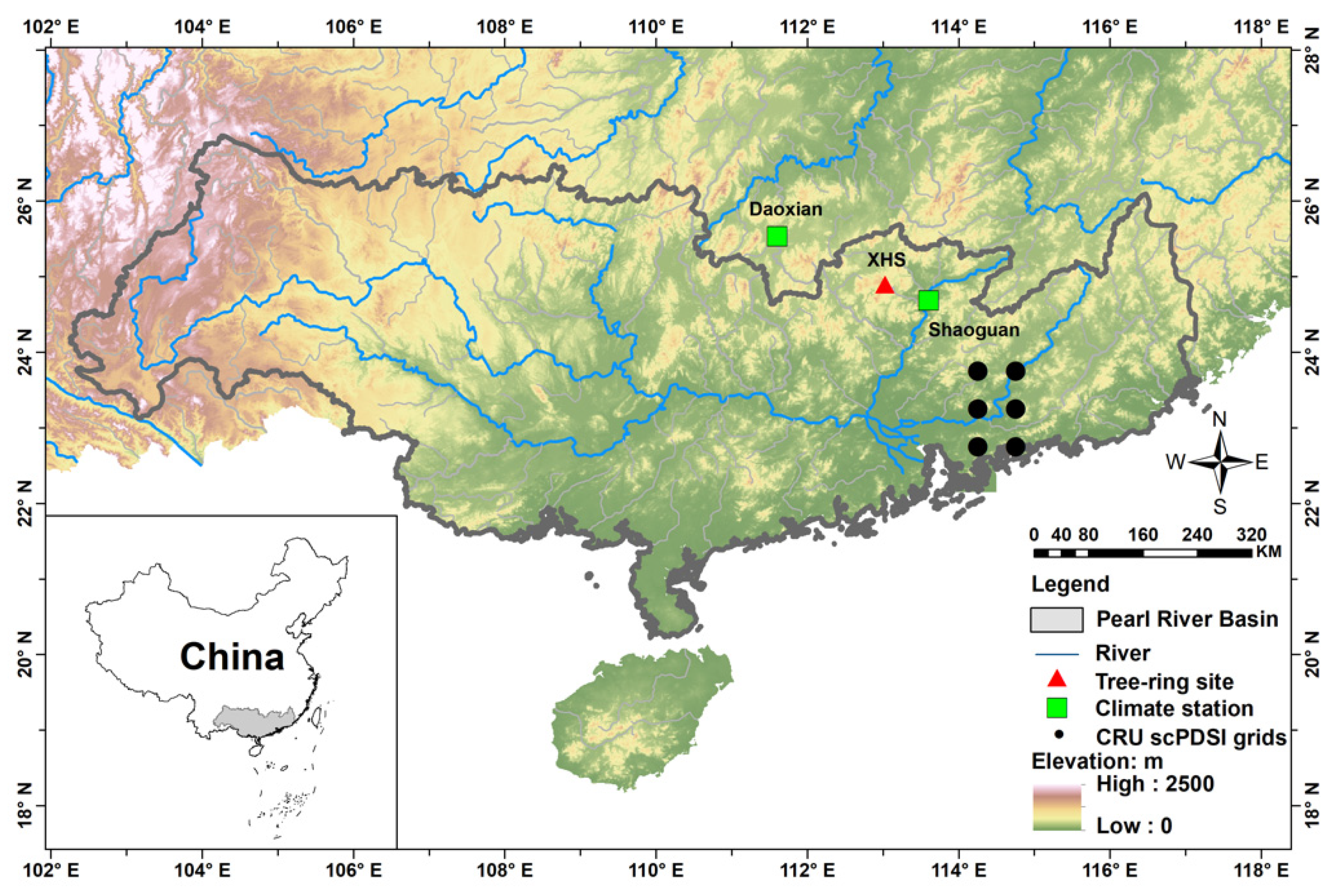
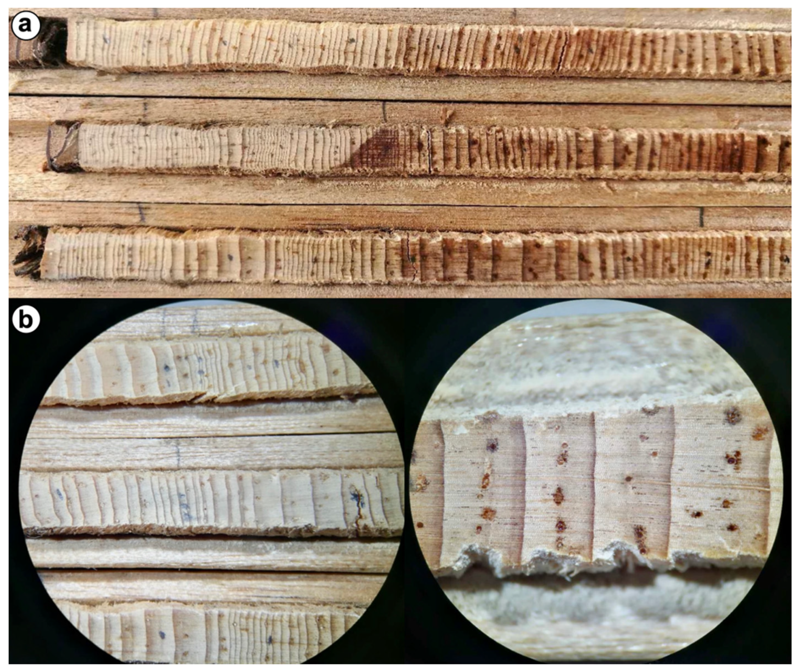
2.1. Tree Ring Data
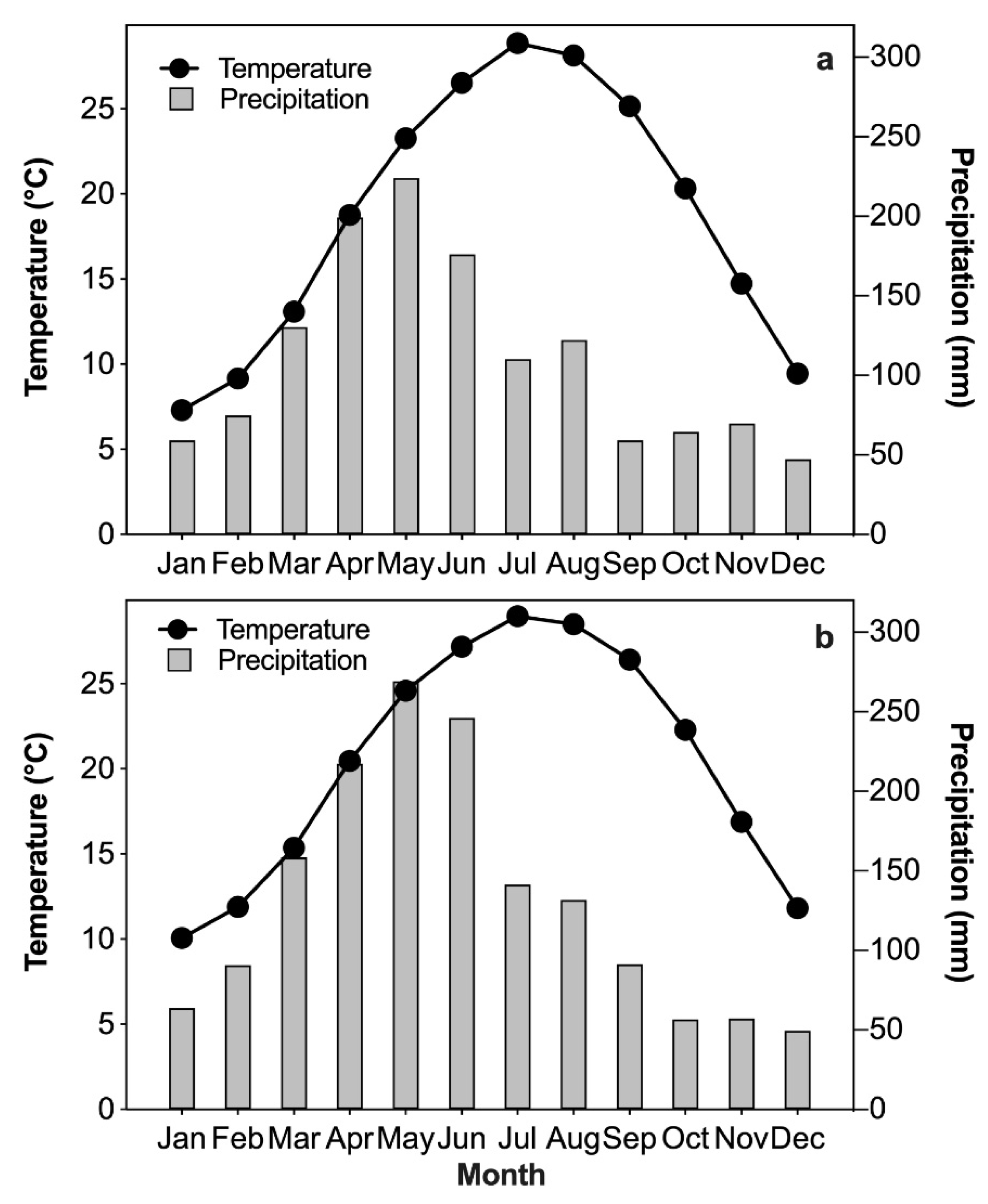
2.2. Climate Data
2.3. Statistical Methods
3. Results
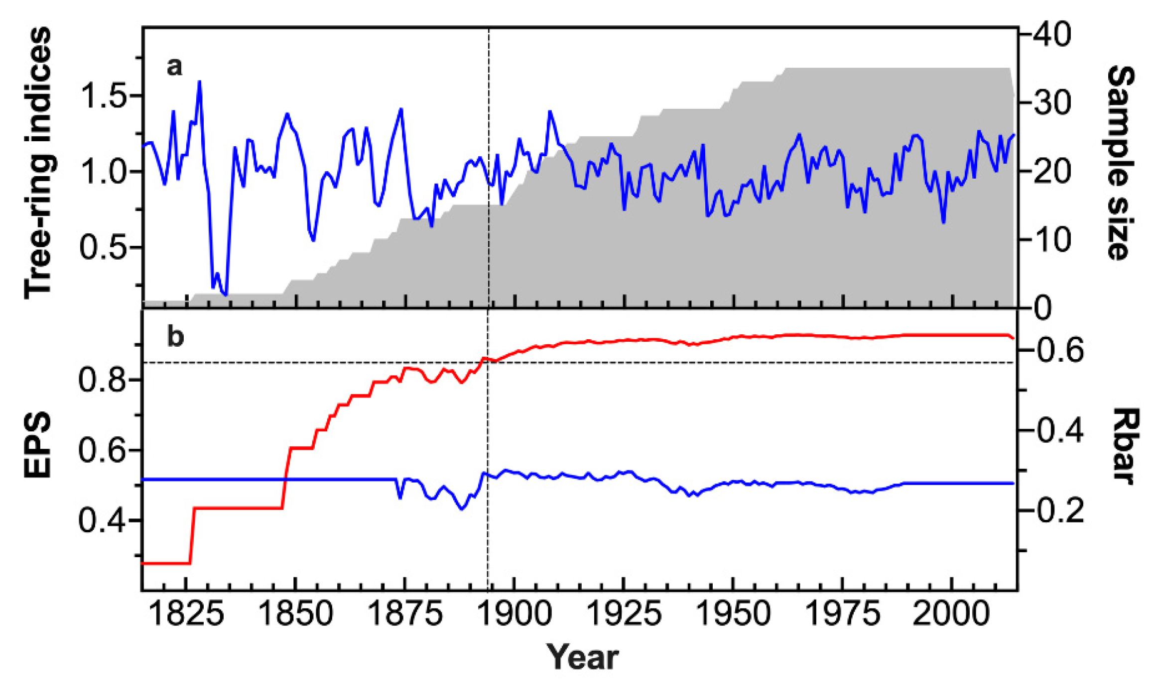
3.1. Statistics of Tree Ring Chronology
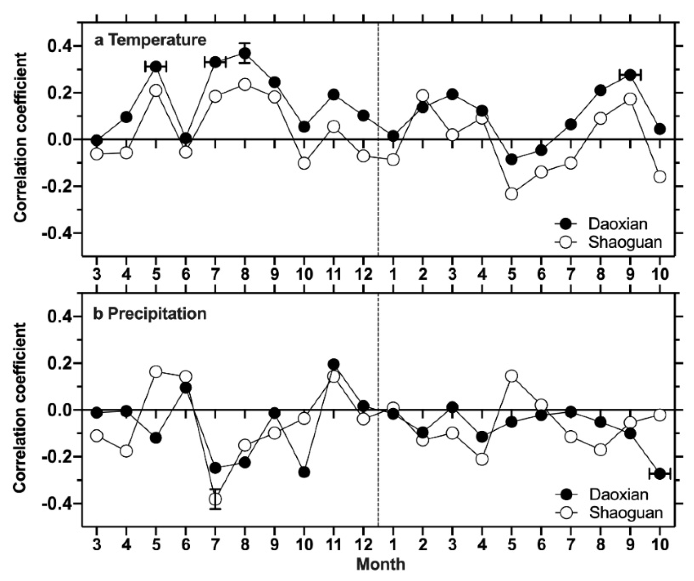
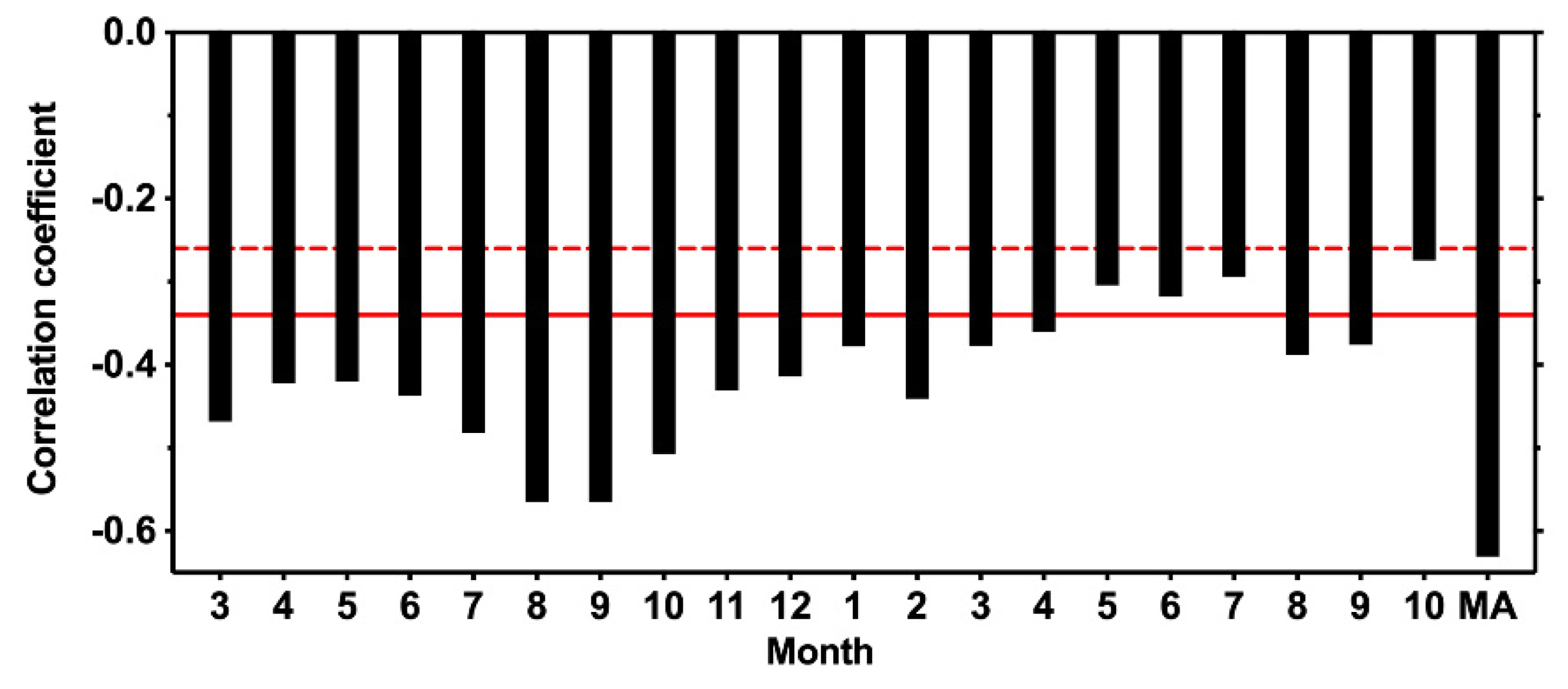
3.2. Climate-Growth Relationship
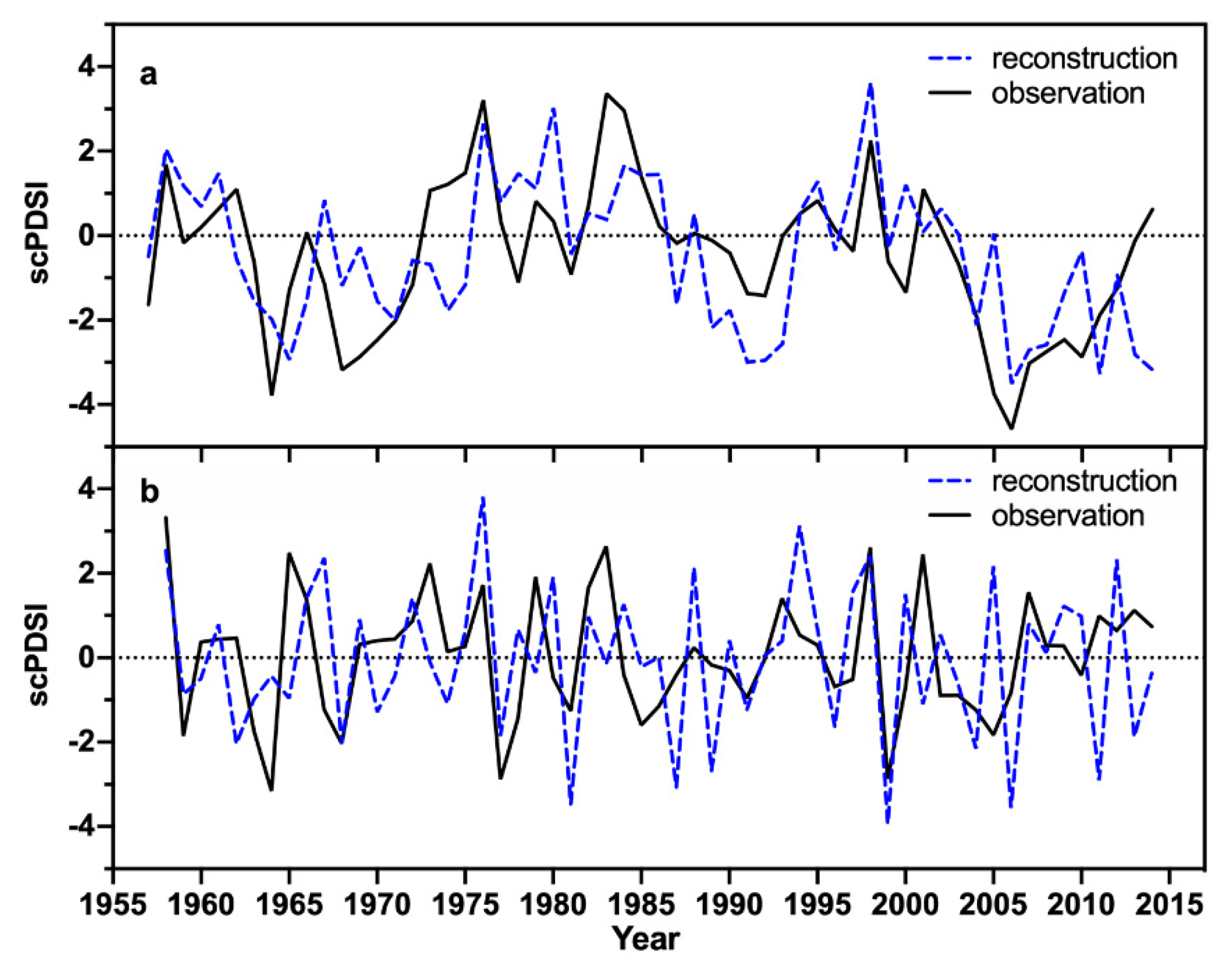
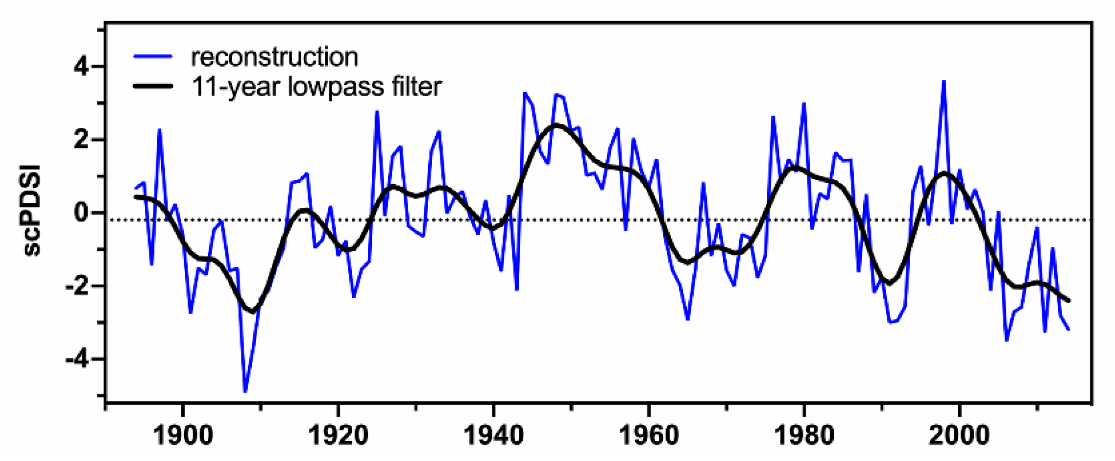
3.3. scPDSI Reconstruction
4. Discussion
4.1. The Climate-Tree Growth Relationship
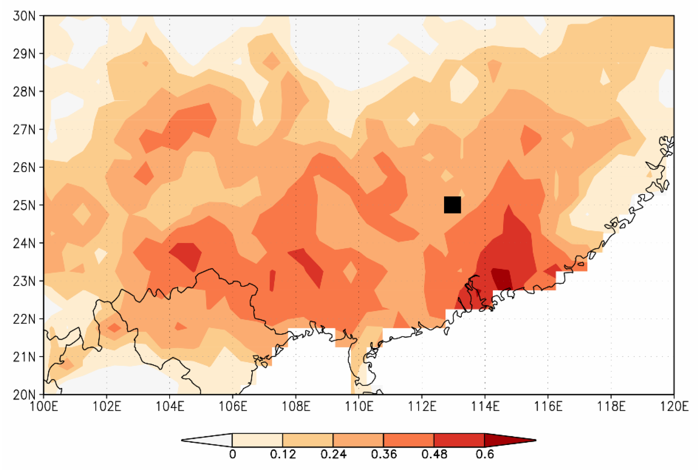
4.2. Tree Ring-Based scPDSI Variability and Spatial Representativeness
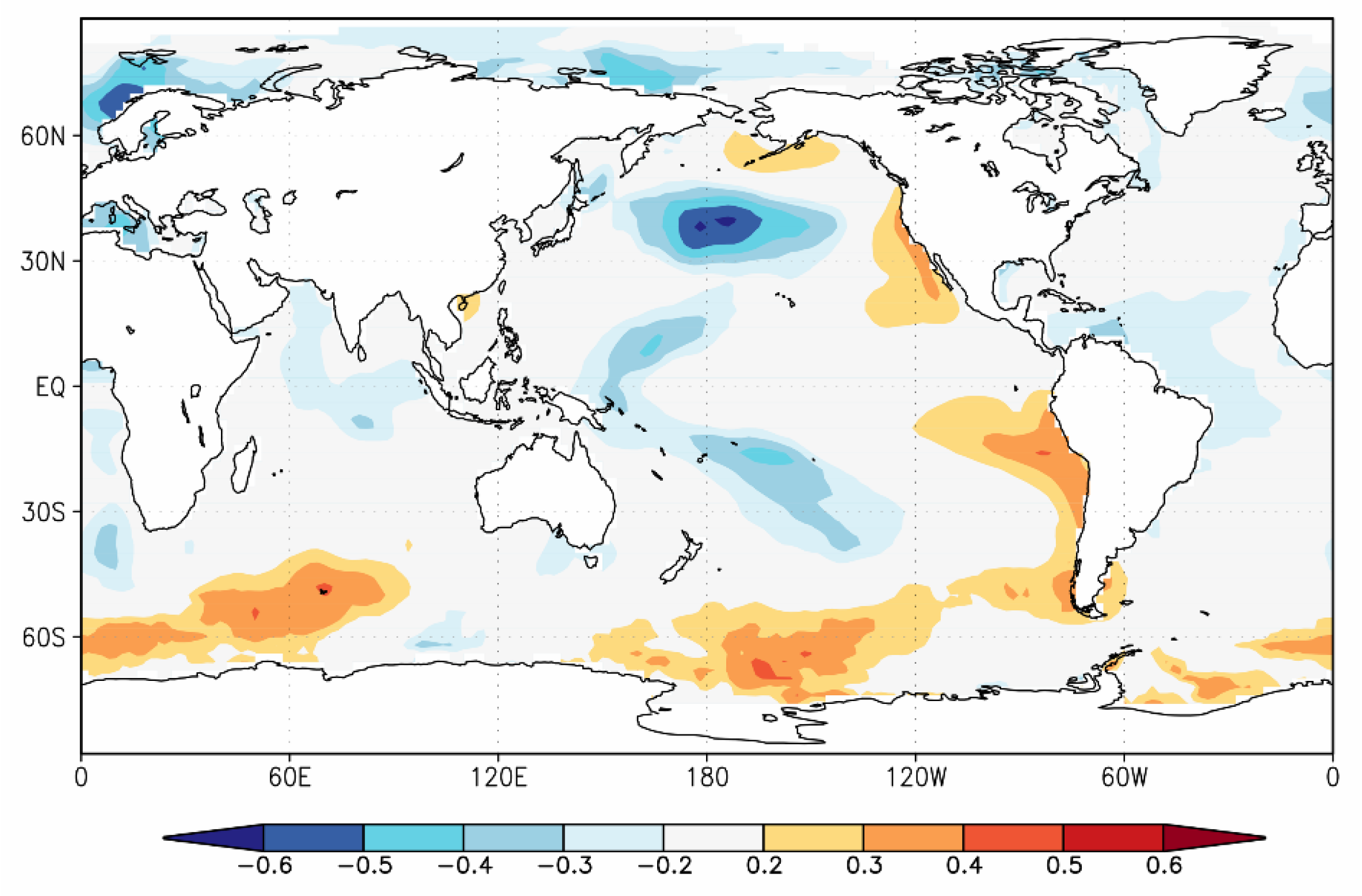
4.3. Linkages of the scPDSI Variability to Pacific SSTs
5. Conclusions
Author Contributions
Funding
Acknowledgments
Conflicts of Interest
References
- Tian, Q.; Yang, S. Regional climatic response to global warming: Trends in temperature and precipitation in the Yellow, Yangtze and Pearl River basins since the 1950s. Quat. Int. 2017, 440, 1–11. [Google Scholar] [CrossRef]
- Zhang, Q.; Xu, C.-Y.; Zhang, Z. Observed changes of drought/wetness episodes in the Pearl River basin, China, using the standardized precipitation index and aridity index. Theor. Appl. Climatol. 2009, 98, 89–99. [Google Scholar] [CrossRef]
- Zhang, Q.; Li, J.; Gu, X.; Shi, P. Is the Pearl River basin, China, drying or wetting? Seasonal variations, causes and implications. Glob. Planet. Chang. 2018, 166, 48–61. [Google Scholar] [CrossRef]
- Fritts, H.C. Tree Rings and Climate; Academic Press: London, UK, 1976. [Google Scholar]
- Briffa, K.R.; Osborn, T.J.; Schweingruber, F.H.; Harris, I.C.; Jones, P.D.; Shiyatov, S.G.; Vaganov, E.A. Low-frequency temperature variations from a northern tree ring density network. J. Geophys. Res. Atmos. 2001, 106, 2929–2941. [Google Scholar] [CrossRef]
- Cook, E.R.; Meko, D.M.; Stahle, D.W.; Cleaveland, M.K. Drought reconstructions for the continental United States. J. Clim. 1999, 12, 1145–1162. [Google Scholar] [CrossRef]
- Büntgen, U.; Tegel, W.; Nicolussi, K.; McCormick, M.; Frank, D.; Trouet, V.; Kaplan, J.O.; Herzig, F.; Heussner, K.-U.; Wanner, H. 2500 years of European climate variability and human susceptibility. Science 2011, 331, 578–582. [Google Scholar]
- Lara, A.; Villalba, R. A 3620-year temperature record from Fitzroya cupressoides tree rings in southern South America. Science 1993, 260, 1104–1106. [Google Scholar] [CrossRef]
- Cook, E.; Bird, T.; Peterson, M.; Barbetti, M.; Buckley, B.; D’Arrigo, R.; Francey, R.; Tans, P. Climatic change in Tasmania inferred from a 1089-year tree-ring chronology of Huon Pine. Science 1991, 253, 1266–1268. [Google Scholar] [CrossRef]
- Esper, J.; Cook, E.R.; Schweingruber, F.H. Low-frequency signals in long tree-ring chronologies for reconstructing past temperature variability. Science 2002, 295, 2250–2253. [Google Scholar] [CrossRef]
- Till, C.; Guiot, J. Reconstruction of precipitation in Morocco since 1100 AD based on Cedrus atlantica tree-ring widths. Quat. Res. 1990, 33, 337–351. [Google Scholar] [CrossRef]
- D’Arrigo, R.; Jacoby, G.; Frank, D.; Pederson, N.; Cook, E.; Buckley, B.; Nachin, B.; Mijiddorj, R.; Dugarjav, C.J.G.R.L. 1738 years of Mongolian temperature variability inferred from a tree-ring width chronology of Siberian pine. Geophys. Res. Lett. 2001, 28, 543–546. [Google Scholar] [CrossRef]
- Shao, X.; Xu, Y.; Yin, Z.-Y.; Liang, E.; Zhu, H.; Wang, S. Climatic implications of a 3585-year tree-ring width chronology from the northeastern Qinghai-Tibetan Plateau. Quat. Sci. Rev. 2010, 29, 2111–2122. [Google Scholar] [CrossRef]
- Zhang, Q.B.; Cheng, G.; Yao, T.; Kang, X.; Huang, J. A 2,326-year tree-ring record of climate variability on the northeastern Qinghai-Tibetan Plateau. Geophys. Res. Lett. 2003, 30. [Google Scholar] [CrossRef]
- Yang, B.; Qin, C.; Wang, J.; He, M.; Melvin, T.M.; Osborn, T.J.; Briffa, K.R. A 3,500-year tree-ring record of annual precipitation on the northeastern Tibetan Plateau. Proc. Natl. Acad. Sci. USA 2014, 111, 2903–2908. [Google Scholar] [CrossRef] [PubMed]
- Li, J.; Xie, S.-P.; Cook, E.R.; Huang, G.; D’arrigo, R.; Liu, F.; Ma, J.; Zheng, X.-T. Interdecadal modulation of El Niño amplitude during the past millennium. Nat. Clim. Chang. 2011, 1, 114–118. [Google Scholar] [CrossRef]
- Bi, Y.; Xu, J.; Gebrekirstos, A.; Guo, L.; Zhao, M.; Liang, E.; Yang, X. Assessing drought variability since 1650 AD from tree-rings on the Jade Dragon Snow Mountain, southwest China. Int. J. Climatol. 2015, 35, 4057–4065. [Google Scholar] [CrossRef]
- Chen, F.; Yuan, Y.; Wei, W.; Yu, S.; Wang, H. tree-ring response of subtropical tree species in southeast China on regional climate and sea-surface temperature variations. Trees 2015, 29, 17–24. [Google Scholar] [CrossRef]
- Cai, Q.; Liu, Y.; Liu, H.; Sun, C.; Wang, Y. Growing-season precipitation since 1872 in the coastal area of subtropical southeast China reconstructed from tree rings and its relationship with the East Asian summer monsoon system. Ecol. Indic. 2017, 82, 441–450. [Google Scholar] [CrossRef]
- Fang, K.; Cai, B.; Liu, X.; Lei, G.; Jiang, X.; Zhao, Y.; Li, H.; Seppä, H. Climate of the late Pleistocene and early Holocene in coastal South China inferred from submerged wood samples. Quat. Int. 2017, 447, 111–117. [Google Scholar] [CrossRef]
- Li, D.; Fang, K.; Li, Y.; Chen, D.; Liu, X.; Dong, Z.; Zhou, F.; Guo, G.; Shi, F.; Xu, C. Climate, intrinsic water-use efficiency and tree growth over the past 150 years in humid subtropical China. PLoS ONE 2017, 12, e0172045. [Google Scholar] [CrossRef]
- Chen, F.; Yuan, Y.; Wei, W.; Yu, S.; Zhang, T. Tree ring-based winter temperature reconstruction for Changting, Fujian, subtropical region of Southeast China, since 1850: Linkages to the Pacific Ocean. Theor. Appl. Climatol. 2012, 109, 141–151. [Google Scholar] [CrossRef]
- Chen, F.; Yuan, Y.-J.; Wei, W.-S.; Yu, S.-L.; Zhang, T.-W. Reconstructed temperature for Yong’an, Fujian, Southeast China: Linkages to the Pacific Ocean climate variability. Glob. Planet. Chang. 2012, 86, 11–19. [Google Scholar] [CrossRef]
- Dong, Z.; Chen, D.; Du, J.; Yang, G.; Bai, M.; Zhou, F.; Zheng, Z.; Ruan, C.; Fang, K. A 241-Year Cryptomeria fortune tree-ring Chronology in Humid Subtropical China and Its Linkages with the Pacific Decadal Oscillation. Atmosphere 2020, 11, 247. [Google Scholar] [CrossRef]
- Wu, Z.; Raven, P.H. Flora of China; Science Press: Beijing, China; Missouri Botanical Garden: St. Louis, MO, USA, 1999; Volume 4. [Google Scholar]
- Holmes, R.L. Computer-assisted quality control in tree-ring dating and measurement. Tree-Ring Bull. 1983, 43, 69–78. [Google Scholar]
- Cook, E.R.; Kairiukstis, L.A. Methods of Dendrochronology: Applications in the Environmental Sciences; Springer Science & Business Media: Berlin/Heidelberg, Germany, 1990. [Google Scholar]
- Melvin, T.M.; Briffa, K.R.; Nicolussi, K.; Grabner, M. Time-varying-response smoothing. Dendrochronologia 2007, 25, 65–69. [Google Scholar] [CrossRef]
- Frank, D.; Esper, J.; Cook, E.R. Adjustment for proxy number and coherence in a large-scale temperature reconstruction. Geophys. Res. Lett. 2007, 34, L16709. [Google Scholar] [CrossRef]
- Osborn, T.; Briffa, K.; Jones, P. Adjusting variance for sample size in tree-ring chronologies and other regional mean timeseries. Dendrochronologia 1997, 15, 89–99. [Google Scholar]
- Melvin, T.M.; Briffa, K.R. A “signal-free” approach to dendroclimatic standardisation. Dendrochronologia 2008, 26, 71–86. [Google Scholar] [CrossRef]
- Wigley, T.M.; Briffa, K.R.; Jones, P.D. On the average value of correlated time series, with applications in dendroclimatology and hydrometeorology. J. Clim. Appl. Meteor. 1984, 23, 201–213. [Google Scholar] [CrossRef]
- Palmer, W.C. Meteorological Drought; US Department of Commerce, Weather Bureau: Silver Spring, MD, USA, 1965; Volume 30. [Google Scholar]
- Wells, N.; Goddard, S.; Hayes, M.J. A self-calibrating Palmer drought severity index. J. Clim. 2004, 17, 2335–2351. [Google Scholar] [CrossRef]
- Harris, I.C.; Jones, P.D. CRU TS4.01: Climatic Research Unit (CRU) Time-Series (TS) Version 4.01 of High-Resolution Gridded Data of Month-by-Month Variation in Climate (Jan. 1901–Dec. 2016), 4 December 2017 ed.; Centre for Environmental Data Analysis: Leeds, UK; University of East Anglia Climatic Research Unit: Norwich, UK, 2017. [Google Scholar] [CrossRef]
- Michaelsen, J. Cross-validation in statistical climate forecast models. J. Clim. Appl. Meteor. 1987, 26, 1589–1600. [Google Scholar] [CrossRef]
- Huang, B.; Thorne, P.W.; Banzon, V.F.; Boyer, T.; Chepurin, G.; Lawrimore, J.H.; Menne, M.J.; Smith, T.M.; Vose, R.S.; Zhang, H.-M. Extended reconstructed sea surface temperature, version 5 (ERSSTv5): Upgrades, validations, and intercomparisons. J. Clim. 2017, 30, 8179–8205. [Google Scholar] [CrossRef]
- Kagawa, A.; Sugimoto, A.; Maximov, T.C. 13CO2 pulse-labelling of photoassimilates reveals carbon allocation within and between tree rings. Plant Cell Environ. 2006, 29, 1571–1584. [Google Scholar] [CrossRef] [PubMed]
- Fan, Z.; Bräuning, A.; Cao, K. tree-ring based drought reconstruction in the central Hengduan Mountains region (China) since AD 1655. Int. J. Climatol. 2008, 28, 1879–1887. [Google Scholar] [CrossRef]
- Fang, K.; Gou, X.; Chen, F.; Li, J.; D’Arrigo, R.; Cook, E.; Yang, T.; Davi, N. Reconstructed droughts for the southeastern Tibetan Plateau over the past 568 years and its linkages to the Pacific and Atlantic Ocean climate variability. Clim. Dyn. 2010, 35, 577–585. [Google Scholar] [CrossRef]
- Fang, K.; Gou, X.; Chen, F.; Yang, M.; Li, J.; He, M.; Zhang, Y.; Tian, Q.; Peng, J. Drought variations in the eastern part of northwest China over the past two centuries: Evidence from tree rings. Clim. Res. 2009, 38, 129–135. [Google Scholar] [CrossRef]
- Li, J.; Shi, J.; Zhang, D.D.; Yang, B.; Fang, K.; Yue, P.H. Moisture increase in response to high-altitude warming evidenced by tree-rings on the southeastern Tibetan Plateau. Clim. Dyn. 2017, 48, 649–660. [Google Scholar] [CrossRef]
- Peng, J.; Liu, Y. Reconstructed droughts for the northeastern Tibetan Plateau since AD 1411 and its linkages to the Pacific, Indian and Atlantic Oceans. Quat. Int. 2013, 283, 98–106. [Google Scholar] [CrossRef]
- Wang, X.; Zhang, Q.; Ma, K.; Xiao, S. A tree-ring record of 500-year dry-wet changes in northern Tibet, China. Holocene 2008, 18, 579–588. [Google Scholar] [CrossRef]
- Hsiao, T.C.; Acevedo, E. Plant responses to water deficits, water-use efficiency, and drought resistance. In Developments in Agricultural and Managed Forest Ecology; Elsevier: Amsterdam, The Netherlands, 1975; Volume 1, pp. 59–84. [Google Scholar]
- Au, T.F.; Maxwell, J.T.; Novick, K.A.; Robeson, S.M.; Warner, S.M.; Lockwood, B.R.; Phillips, R.P.; Harley, G.L.; Telewski, F.W.; Therrell, M.D.; et al. Demographic shifts in eastern US forests increase the impact of late-season drought on forest growth. Ecography 2020, 43, 1475–1486. [Google Scholar] [CrossRef]
- Martin-Benito, D.; Pederson, N. Convergence in drought stress, but a divergence of climatic drivers across a latitudinal gradient in a temperate broadleaf forest. J. Biogeogr. 2015, 42, 925–937. [Google Scholar] [CrossRef]
- Rozas, V.; Zas, R.; García-González, I. Contrasting effects of water availability on Pinus pinaster radial growth near the transition between the Atlantic and Mediterranean biogeographical regions in NW Spain. Eur. J. For. Res. 2011, 130, 959–970. [Google Scholar] [CrossRef]
- Graham, E.A.; Mulkey, S.S.; Kitajima, K.; Phillips, N.G.; Wright, S.J. Cloud cover limits net CO2 uptake and growth of a rainforest tree during tropical rainy seasons. Proc. Natl. Acad. Sci. USA 2003, 100, 572–576. [Google Scholar] [CrossRef] [PubMed]
- Caldwell, M.M.; Richards, J.H. Hydraulic lift: Water efflux from upper roots improves effectiveness of water uptake by deep roots. Oecologia 1989, 79, 1–5. [Google Scholar] [CrossRef]
- Ritchie, J. Soil water balance and plant water stress. In Understanding Options for Agricultural Production; Springer: Berlin/Heidelberg, Germany, 1998; pp. 41–54. [Google Scholar]
- Liu, Y.; Fang, C.X.; Li, Q.; Song, H.M.; Ta, W.Y.; Zhao, G.J.; Sun, C.F. tree-ring δ18O based PDSI reconstruction in the Mt. Tianmu region since 1618 AD and its connection to the East Asian summer monsoon. Ecol. Indic. 2019, 104, 636–647. [Google Scholar] [CrossRef]
- Shi, H.; Wang, B.; Cook, E.R.; Liu, J.; Liu, F. Asian Summer Precipitation over the Past 544 Years Reconstructed by Merging Tree Rings and Historical Documentary Records. J. Clim. 2018, 31, 7845–7861. [Google Scholar] [CrossRef]
- Xu, C.X.; Ge, J.Y.; Nakatsuka, T.; Yi, L.; Zheng, H.Z.; Sano, M. Potential utility of tree ring δ18O series for reconstructing precipitation records from the lower reaches of the Yangtze River, southeast China. J. Geophys. Res. Atmos. 2016, 121, 3954–3968. [Google Scholar] [CrossRef]
- Wang, B.; Wu, R.; Fu, X. Pacific-East Asian teleconnection: How does ENSO affect East Asian climate? J. Clim. 2000, 13, 1517–1536. [Google Scholar] [CrossRef]
- Böhner, J. General climatic controls and topoclimatic variations in Central and High Asia. Boreas 2006, 35, 279–295. [Google Scholar] [CrossRef]
- Zhang, R.; Sumi, A.; Kimoto, M. A diagnostic study of the impact of El Nino on the precipitation in China. Adv. Atmos. Sci. 1999, 16, 229–241. [Google Scholar] [CrossRef]
- Li, T.; Zhang, Y.; Chang, C.P.; Wang, B. On the relationship between Indian Ocean sea surface temperature and Asian summer monsoon. Geophys. Res. Lett. 2001, 28, 2843–2846. [Google Scholar] [CrossRef]
- Zhao, Y.; Zou, X.; Cao, L.; Xu, X. Changes in precipitation extremes over the Pearl River Basin, southern China, during 1960–2012. Quat. Int. 2014, 333, 26–39. [Google Scholar] [CrossRef]
- Li, Y.; Fang, K.; Cao, C.; Li, D.; Zhou, F.; Dong, Z.; Zhang, Y.; Gan, Z. A tree-ring chronology spanning 210 years in the coastal area of southeastern China, and its relationship with climate change. Clim. Res. 2016, 67, 209–220. [Google Scholar] [CrossRef]


| Site Code | Location (Latitude, Longitude) | Elevation (m a.s.l.) | Cores/Trees | Time Span (AD) | SD | MS | AC1 | Rbar | EPS |
|---|---|---|---|---|---|---|---|---|---|
| XHS | 24.90° N, 113.02° E | 1403 | 35/20 | 1815–2014 | 0.21 | 0.29 | 0.65 | 0.26 | 0.92 |
| Calibration | Verification | |||||
|---|---|---|---|---|---|---|
| Period | R | R2 | p | Period | RE | CE |
| 1957–1985 | 0.522 | 0.27 | 0.002 | 1986–2014 | 0.353 | 0.164 |
| 1986–2014 | 0.495 | 0.25 | 0.003 | 1957–1985 | 0.327 | 0.187 |
| Rank | Dry Year | scPDSI | Wet Year | scPDSI |
|---|---|---|---|---|
| 1 | 1908 | −4.915 | 1998 | 3.631 |
| 2 | 1909 | −3.740 | 1944 | 3.301 |
| 3 | 2006 | −3.508 | 1948 | 3.236 |
| 4 | 2011 | −3.271 | 1949 | 3.162 |
| 5 | 2014 | −3.181 | 1980 | 3.023 |
| 6 | 1991 | −2.995 | 1945 | 2.941 |
| 7 | 1992 | −2.952 | 1925 | 2.806 |
| 8 | 1965 | −2.936 | 1976 | 2.650 |
| 9 | 2013 | −2.811 | 1951 | 2.340 |
| 10 | 1901 | −2.754 | 1956 | 2.323 |
© 2020 by the authors. Licensee MDPI, Basel, Switzerland. This article is an open access article distributed under the terms and conditions of the Creative Commons Attribution (CC BY) license (http://creativecommons.org/licenses/by/4.0/).
Share and Cite
Li, T.; Li, J.; Au, T.F.; Zhang, D.D. Moisture Variability in the East Pearl River Basin since 1894 CE Inferred from Tree Ring Records. Atmosphere 2020, 11, 1075. https://doi.org/10.3390/atmos11101075
Li T, Li J, Au TF, Zhang DD. Moisture Variability in the East Pearl River Basin since 1894 CE Inferred from Tree Ring Records. Atmosphere. 2020; 11(10):1075. https://doi.org/10.3390/atmos11101075
Chicago/Turabian StyleLi, Teng, Jinbao Li, Tsun Fung Au, and David D. Zhang. 2020. "Moisture Variability in the East Pearl River Basin since 1894 CE Inferred from Tree Ring Records" Atmosphere 11, no. 10: 1075. https://doi.org/10.3390/atmos11101075
APA StyleLi, T., Li, J., Au, T. F., & Zhang, D. D. (2020). Moisture Variability in the East Pearl River Basin since 1894 CE Inferred from Tree Ring Records. Atmosphere, 11(10), 1075. https://doi.org/10.3390/atmos11101075