Sharing Cultural Values Through 3D Point-Cloud-Based Documentation of Transylvanian Heritage



Highlights
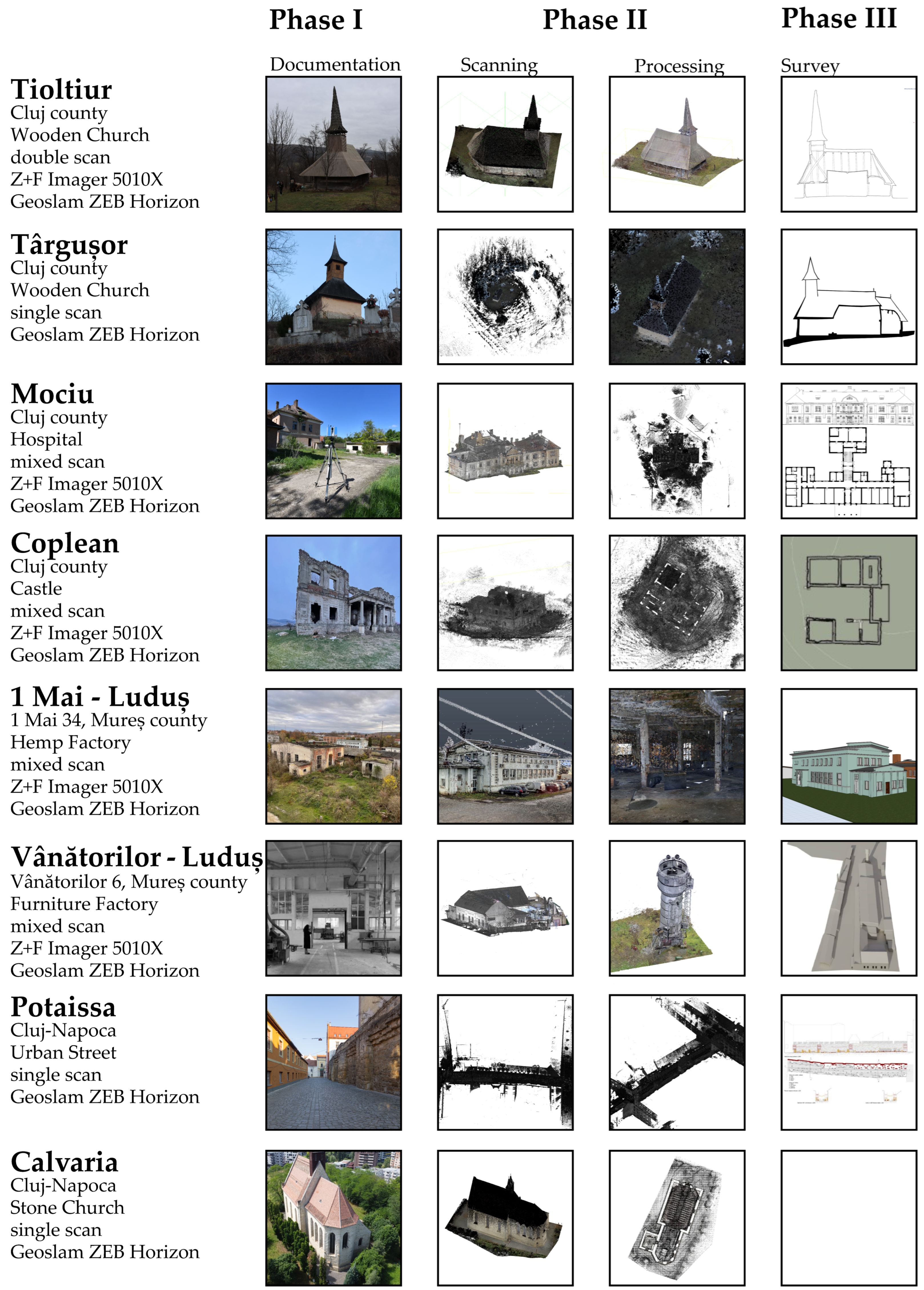
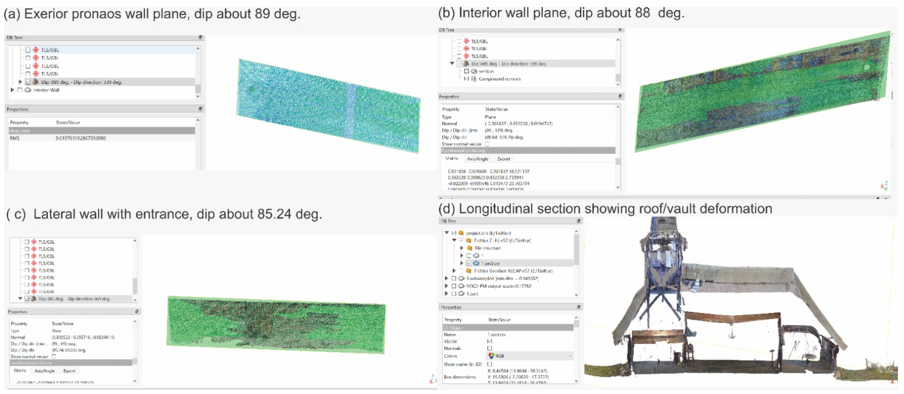
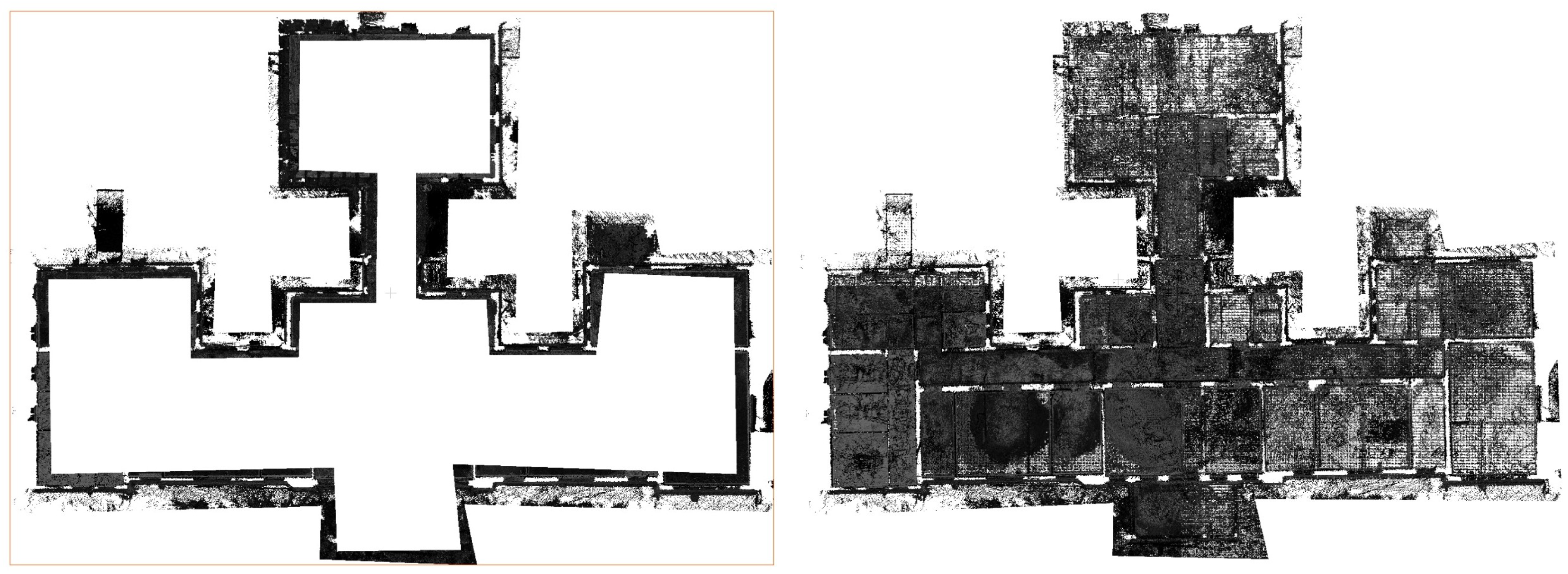
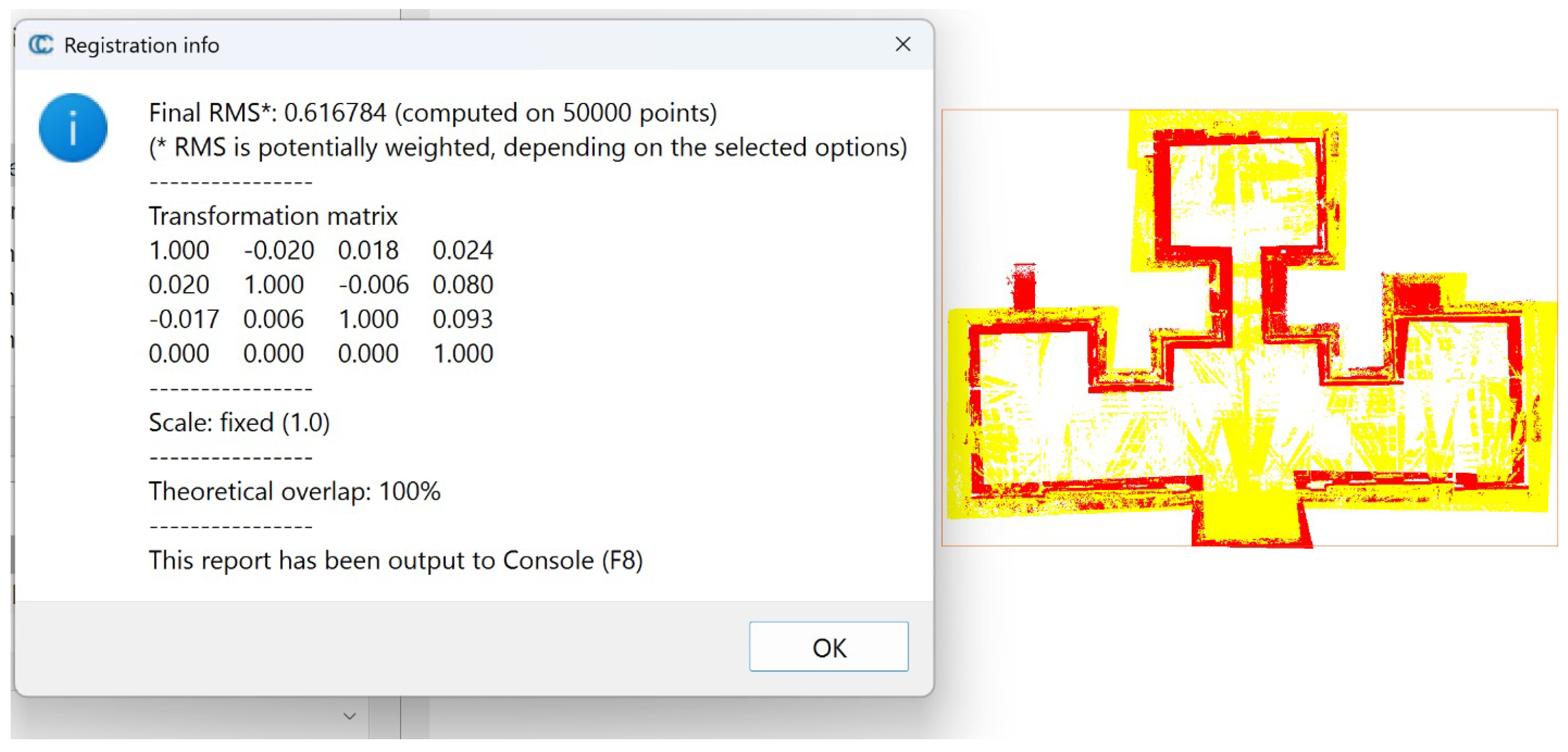
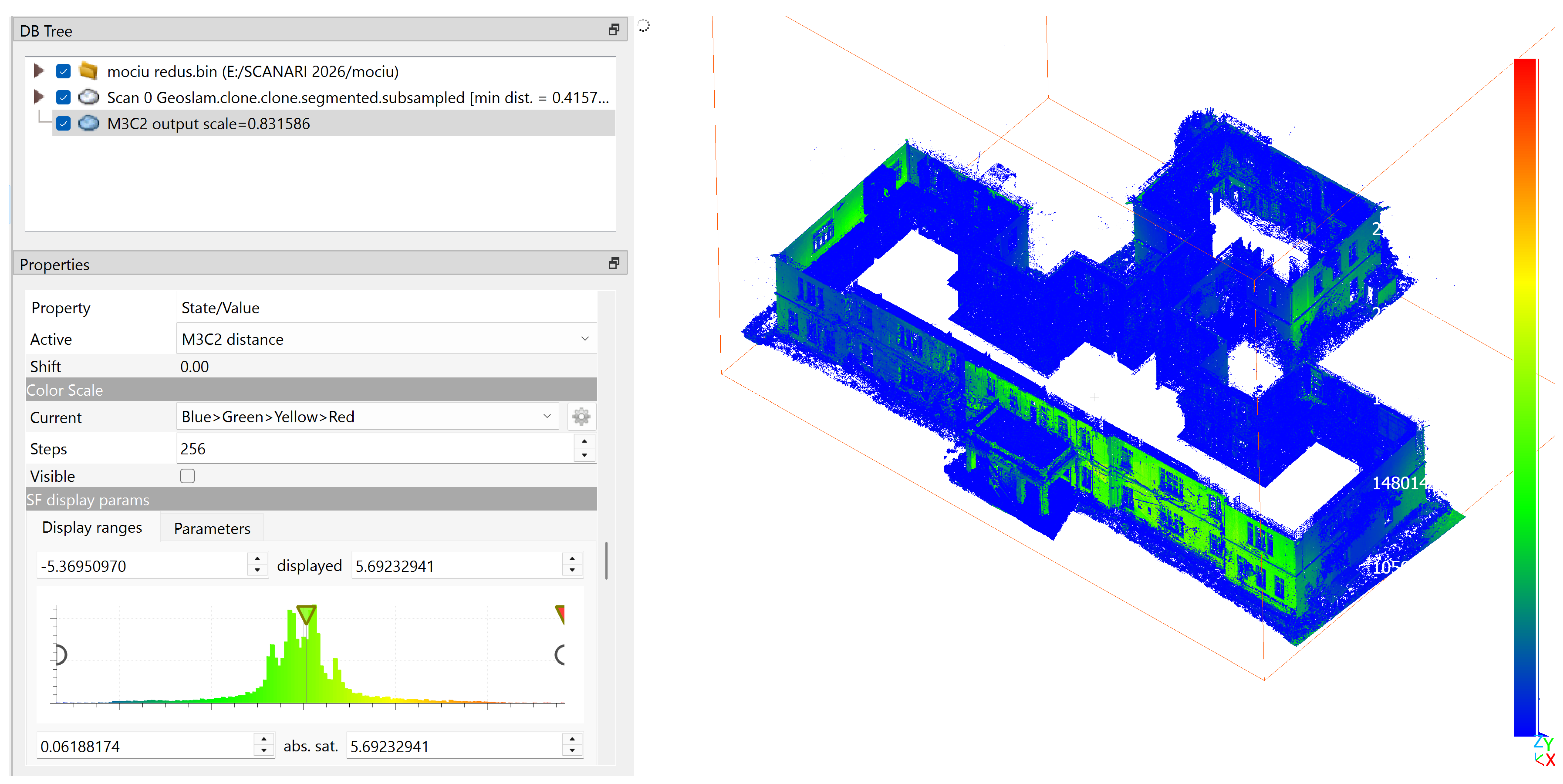
- 3D point-cloud workflows using combined terrestrial and mobile laser scanning reliably document diverse Transylvanian heritage sites and support deformation and decay reading.
- Embedding this dual-sensor survey pipeline in an architectural curriculum increases students’ technical 3D skills and their ability to interpret cultural values from digital heritage data.
- Mixed TLS–SLAM point-cloud survey strategies provide a transferable model for evidence-based heritage documentation that can feed HBIM, digital-twin and monitoring workflows in other contexts.
- Treating point clouds as shared digital heritage records helps train future architects as responsible co-creators of archives that support long-term conservation, education and public access.
Abstract
1. Introduction
2. Materials and Methods
2.1. Survey Pipeline
2.2. Equipment and Acquisition Strategies
2.3. Pre- and Post-Workshop Questionnaires
2.3.1. Design and Rationale
2.3.2. Instrument and Constructs
2.3.3. Scales and Analysis
2.3.4. Limitations of the Survey Design
3. Results
3.1. Technical Results: Sensor Performance and Site-Specific Outcomes
3.2. Transition: From Technical Documentation to Educational Outcomes
3.3. Educational Results: Questionnaire Indicators and Student Perceptions
3.3.1. Samples, Pairing and Analytical Approach
3.3.2. Baseline Profile (Pre-Workshop)
3.3.3. Post-Workshop Indicators
3.3.4. Thematic Analysis of Open Responses
3.3.5. Summary of Indicators
4. Discussion
4.1. Sensor Complementarity and Survey Performance
4.2. Point Clouds as Diagnostic and Interpretive Media
4.3. Educational Implications and Digital Heritage Workflows
4.4. Transferability of the Workflow
4.5. Study Limitations and Future Directions
Author Contributions
Funding
Institutional Review Board Statement
Informed Consent Statement
Data Availability Statement
Acknowledgments
Conflicts of Interest
Appendix A. Questionnaire Items (Supplementary)
Appendix A.1. Pre-Workshop Questionnaire (Relevé 3D și Patrimoniu—Chestionar PRE Workshop)
- Q1. An de studiu. (Year of study.)—categorical: Year 3/4/5/6/ Graduate.
- Q2. Ai mai participat până acum la proiecte de relevéu pe situri reale (indiferent dacă au fost digitale sau analogice)? (Have you previously taken part in survey projects on real sites, whether digital or analogue?)—No, this is my first project/Yes, once/Yes, 2–3 times/Yes, more than 3 times.
- Q3. Ai mai lucrat până acum cu nori de puncte (vizualizare sau procesare)? (Have you previously worked with point clouds, viewing or processing?)—Not at all/Only a very brief/demo experience/Worked a few times/Worked regularly in other projects.
- Q4. Ai mai folosit VR (realitate virtuală) în context educațional sau profesional (nu doar jocuri)? (Have you used VR in an educational or professional context, not just games?)—Not at all/One experience/A few times/Fairly often.
- Q5. Înțeleg, în linii mari, ce este un nor de puncte și cum este generat. (I broadly understand what a point cloud is and how it is generated.)
- Q6. Știu câteva exemple de situații în care nori de puncte sunt utili în arhitectură sau patrimoniu. (I know a few examples of situations where point clouds are useful in architecture or heritage.)
- Q7. Mă simt confortabil să lucrez cu software 3D (de ex. CAD, modelare 3D, vizualizatoare de nori de puncte). (I feel comfortable working with 3D software, e.g., CAD, 3D modelling, point-cloud viewers.)
- Q8. Mă aștept ca lucrul cu nori de puncte să fie mai degrabă tehnic și dificil. (I expect working with point clouds to be rather technical and difficult.)
- Q9. Mă aștept ca lucrul cu nori de puncte să îmi fie util în proiecte viitoare (atelier, diplomă, profesie). (I expect working with point clouds to be useful in my future projects: studio, diploma, profession.)
- Q10. Mă simt încrezător/încrezătoare în capacitatea mea de a identifica valori culturale (istorice, sociale, simbolice) ale unui sit de patrimoniu. (I feel confident in my ability to identify the cultural values—historical, social, symbolic—of a heritage site.)
- Q11. Până acum, am avut mai multă experiența cu abordări clasice de relevéu (măsurători, schițe, fotografii) decât cu metode digitale avansate. (So far I have had more experience with classical survey approaches—measurements, sketches, photos—than with advanced digital methods.)
- Q12. Mă aștept ca acest workshop să mă ajute să leg mai bine partea tehnică (scanare, 3D) de înțelegerea patrimoniului și a contextului local. (I expect this workshop to help me better connect the technical side—scanning, 3D—with understanding heritage and the local context.)
- Q13. Sunt interesat(ă) în mod special de siturile din Transilvania și de felul în care acestea exprimă identitatea regională. (I am especially interested in Transylvanian sites and how they express regional identity.)
- Q14. Consider că documentarea digitală poate contribui real la protejarea și transmiterea patrimoniului către viitoarele generații. (I consider that digital documentation can genuinely contribute to protecting and transmitting heritage to future generations.)
- Q15. Înțeleg, în linii mari, ce înseamnă arhivă digitală pentru patrimoniu (stocare, organizare, acces pe termen lung). (I broadly understand what a digital archive for heritage means: storage, organisation, long-term access.)
- Q16. Am o idee (chiar dacă vagă) despre conceptul de digital twin pentru o clădire sau un sit. (I have an idea, even if vague, of the digital-twin concept for a building or site.)
- Q17. Mă aștept ca în acest workshop să învăț cum pot contribui responsabil la o arhivă digitală (prin modul în care colectez, denumesc și predau datele). (I expect to learn in this workshop how I can responsibly contribute to a digital archive through how I collect, name and hand over data.)
- Q18. Sunt curios/curioasă să văd cum se pot folosi VR și nori de puncte împreună pentru a înțelege mai bine siturile de patrimoniu. (I am curious to see how VR and point clouds can be used together to better understand heritage sites.)
- Q19. Ce ți-ai dori cel mai mult să înveți sau să clarifici în cadrul unui workshop (tehnic sau legat de patrimoniu)? (What would you most like to learn or clarify in a workshop, technical or heritage-related?)—open.
- Q20. Care este cea mai mare îngrijorare sau dificultate pe care o anticipezi (de ex. partea tehnică, lucrul în echipă, timpul, partea de interpretare)? (What is the biggest concern or difficulty you anticipate, e.g.,the technical side, teamwork, time, interpretation?)—open.
- Q21–Q22. Logistical items on attending a half-day digital-tools demonstration and on receiving related event information (email address). Not analysed.
Appendix A.2. Post-Workshop Questionnaire (Experiențe de Relevéu 3D și Patrimoniu—Chestionar POST Workshop)
- Q1. An de studiu. (Year of study.)—categorical.
- Q2. Pe câte situri de patrimoniu ai lucrat în cadrul acestor proiecte? (On how many heritage sites did you work within these projects?)—categorical.
- Q3. La care dintre relevee/situri ai participat? (poți selecta unul sau mai multe) (Which surveys/sites did you take part in? Select one or more.)—multi-select.
- Q4. Cum îți descrii nivelul general de experiența cu proiectele reale? (How would you describe your overall level of experience with real projects?)—categorical.
- Q5. Înainte de aceste proiecte, câte experiențe concrete aveai cu nori de puncte (vizualizare, procesare, modelare)? (Before these projects, how many concrete experiences did you have with point clouds—viewing, processing, modelling?)—ordinal: 0 (none)/1 (a single short experience)/2–3 experiences/more.
- Q6. În prezent, înțeleg principiile de bază ale norilor de puncte și modul în care sunt obținuți din scanare 3D. (I now understand the basic principles of point clouds and how they are obtained from 3D scanning.)—Likert.
- Q7. Sunt capabil(ă) să contribui la curățarea și registrarea unui nor de puncte. (I am able to contribute to cleaning and registering a point cloud.)—Likert.
- Q8. Pot folosi norii de puncte pentru a extrage măsurători simple și secțiuni relevante. (I can use point clouds to extract simple measurements and relevant sections.)—Likert.
- Q9. Mă simt mai pregătit(ă) să folosesc nori de puncte și instrumente 3D în proiectele mele viitoare. (I feel better prepared to use point clouds and 3D tools in my future projects.)—Likert.
- Q10. Proiectul m-a ajutat să înțeleg mai bine cum sistemele de construcție (lemn, zidărie, piatră etc.) influențează lectura unui sit de patrimoniu. (The project helped me better understand how construction systems—timber, masonry, stone—shape the reading of a heritage site.)—Likert.
- Q11. Pot identifica și descrie câteva valori culturale importante ale sitului/siturilor pe care le-am documentat. (I can identify and describe some important cultural values of the site(s) I documented.)—Likert.
- Q12. Lucrul cu date 3D (nori de puncte, modele) mi-a schimbat sau rafinat modul în care privesc patrimoniul din Transilvania. (Working with 3D data changed or refined how I view Transylvanian heritage.)—Likert.
- Q13. Am folosit sau am experimentat VR în legătură cu aceste situri sau cu alte proiecte de patrimoniu. (I used or experimented with VR in connection with these sites or other heritage projects.)—Likert (1 = not at all, 5 = yes, intensively/repeatedly).
- Q14. Experiența VR (acolo unde a existat) m-a ajutat să înțeleg mai bine spațiul, detaliile și starea de conservare a sitului. (The VR experience, where it existed, helped me better understand the space, details and conservation state of the site.)—Likert, conditional; option “Nu am folosit VR” (I did not use VR) available.
- Q15. Înțeleg în linii mari ce înseamnă arhivare digitală a patrimoniului. (I broadly understand what digital archiving of heritage means.)—Likert.
- Q16. Am o idee clară despre ce înseamnă un “digital twin” al unui sit de patrimoniu. (I have a clear idea of what a digital twin of a heritage site means.)—Likert.
- Q17. Consider că proiectele noastre contribuie la un proces de conservare digitală a siturilor. (I consider that our projects contribute to a process of digital conservation of the sites.)—Likert.
- Q18. M-am simțit responsabil(ă) pentru calitatea și utilitatea pe termen lung a datelor pe care le-am produs, ca parte a unei arhive digitale/digital twin. (I felt responsible for the quality and long-term usefulness of the data I produced, as part of a digital archive/digital twin.)—Likert.
- Q19. Colaborarea în echipă a îmbunătățit atât calitatea tehnică a rezultatelor, cât și înțelegerea patrimoniului. (Team collaboration improved both the technical quality of the results and the understanding of heritage.)—Likert.
- Q20. Care este cel mai important lucru cu care simți că ai rămas în urma acestei experiențe (tehnic sau legat de patrimoniu)? (What is the most important thing you feel you took away from this experience, technical or heritage-related?)—open.
- Q21. Dă un exemplu concret în care norul de puncte, modelul 3D sau experiența VR ți-a arătat ceva despre clădire sau sit pe care nu îl observaseși la fața locului. (Give a concrete example where the point cloud, 3D model or VR showed you something about the building or site that you had not noticed on-site.)—open.
- Q22. Dacă ar fi să dai un singur sfat grupei de anul viitor, care ar fi acesta? (If you had to give a single piece of advice to next year’s group, what would it be?)—open.
References
- Chiabrando, F.; Lo Turco, M.; Rinaudo, F. Modeling the decay in an HBIM starting from 3D point clouds. A followed approach for cultural heritage knowledge. Int. Arch. Photogramm. Remote Sens. Spat. Inf. Sci. 2017, 42, 605–612. [Google Scholar] [CrossRef] [Scilit]
- Crisan, A.; Pepe, M.; Costantino, D.; Herban, S. From 3D Point Cloud to an Intelligent Model Set for Cultural Heritage Conservation. Heritage 2024, 7, 1419–1437. [Google Scholar] [CrossRef] [Scilit]
- Visutsak, P.; Liu, X.; Choothong, C.; Pensiri, F. SIFT-Based Depth Estimation for Accurate 3D Reconstruction in Cultural Heritage Preservation. Appl. Syst. Innov. 2025, 8, 43. [Google Scholar] [CrossRef] [Scilit]
- Gagliolo, S.; Ausonio, E.; Federici, B.; Ferrando, I.; Passoni, D.; Sguerso, D. 3D cultural heritage documentation: A comparison between different photogrammetric software and their products. Int. Arch. Photogramm. Remote Sens. Spat. Inf. Sci. 2018, XLII-2, 347–354. [Google Scholar] [CrossRef] [Scilit]
- D’Agostino, G.; Figuera, M.; Russo, G.; Galizia, M.; Militello, P.M. integrated 3D survey for the documentation and visualization of a rock-cut underground built heritage. Int. Arch. Photogramm. Remote Sens. Spat. Inf. Sci. 2022, XLVI-2/W1-2022, 167–174. [Google Scholar] [CrossRef] [Scilit]
- Selim, G.; Bachagha, N.; Alobaydi, D.; Farhan, S.L.; Tarabeih, A. Integrated Surveying for Architectural Heritage Documentation in Iraq: From LiDAR Scanner to GIS Applications. Remote Sens. 2025, 17, 3632. [Google Scholar] [CrossRef] [Scilit]
- Li, W.; Pan, J.; Hasegawa, K.; Li, L.; Tanaka, S. Missing Region Completion Network for Large-Scale Laser-Scanned Point Clouds: Application to Transparent Visualization of Cultural Heritage. Remote Sens. 2024, 16, 2758. [Google Scholar] [CrossRef] [Scilit]
- Kong, X.; Hucks, R.G. Preserving our heritage: A photogrammetry-based digital twin framework for monitoring deteriorations of historic structures. Autom. Constr. 2023, 152, 104928. [Google Scholar] [CrossRef]
- Moyano, J.; Justo-Estebaranz, Á.; Nieto-Julián, J.E.; Barrera, A.O.; Fernández-Alconchel, M. Evaluation of records using terrestrial laser scanner in architectural heritage for information modeling in HBIM construction: The case study of the La Anunciación church (Seville). J. Build. Eng. 2022, 62, 105190. [Google Scholar] [CrossRef] [Scilit]
- Yang, S.; Xu, S.; Huang, W. 3D Point Cloud for Cultural Heritage: A Scientometric Survey. Remote Sens. 2022, 14, 5542. [Google Scholar] [CrossRef] [Scilit]
- Yang, S.; Hou, M.; Li, S. Three-Dimensional Point Cloud Semantic Segmentation for Cultural Heritage: A Comprehensive Review. Remote Sens. 2023, 15, 548. [Google Scholar] [CrossRef] [Scilit]
- Li, Y.; Du, Y.; Yang, M.; Liang, J.; Bai, H.; Li, R.; Law, A. A review of the tools and techniques used in the digital preservation of architectural heritage within disaster cycles. Herit. Sci. 2023, 11, 199. [Google Scholar] [CrossRef] [Scilit]
- Tommasi, C.; Fiorillo, F.; Jiménez Fernández-Palacios, B.; Achille, C. access and web-sharing of 3D digital documentation of environmental and architectural heritage. Int. Arch. Photogramm. Remote Sens. Spat. Inf. Sci. 2019, XLII-2/W9, 707–714. [Google Scholar] [CrossRef] [Scilit][Green Version]
- Mayer, I.; Mitterecker, T. Surveying for architectural students: As simple as possible–as much as necessary. Isprs Ann. Photogramm. Remote Sens. Spat. Inf. Sci. 2017, IV-2/W2, 135–141. [Google Scholar] [CrossRef] [Scilit]
- Kowalski, S.; Lebiedź, J.; Parrinello, S.; Picchio, F. New skills for architects: 3D scanning for an immersive experience in architectural education. Glob. J. Eng. Educ. 2024, 26, 115–121. [Google Scholar]
- Brown, C.J.; Yao, S.; Zhang, X.; Brown, C.J.; Caven, J.B.; Krusche, K.U.; Wang, C. Visualizing digital architectural data for heritage education. In Proceedings of the IS&T Conference on Visualization and Data Analysis, Online, 16–19 January 2023. [Google Scholar] [CrossRef] [Scilit]
- Álvarez, M.; Morón, A.; Zaragoza, A.; Ferrández, D.; Morón, C. Transforming architectural education: A teaching innovation approach using laser scanning and bim. In Proceedings of the 19th International Technology, Education and Development Conference, Valencia, Spain, 3–5 March 2025; pp. 5438–5444. [Google Scholar] [CrossRef] [Scilit]
- Jiang, Y.; Liang, X.; Coscia, C. Assessing Digital Tools in Education Process for Cultural Heritage: A Literature Review. Int. Arch. Photogramm. Remote Sens. Spat. Inf. Sci. 2025, XLVIII-M-9-2025, 645–652. [Google Scholar] [CrossRef] [Scilit]
- Chen, F.; Ma, P.; Chen, S.; Hu, Q.; Guo, H. Remote sensing for cultural heritage: A systematic review. Int. J. Appl. Earth Obs. Geoinf. 2026, 146, 105039. [Google Scholar] [CrossRef] [Scilit]
- De Fino, M.; Galantucci, R.A.; Fatiguso, F. Condition Assessment of Heritage Buildings via Photogrammetry: A Scoping Review from the Perspective of Decision Makers. Heritage 2023, 6, 7031–7066. [Google Scholar] [CrossRef] [Scilit]
- Capolupo, A. Accuracy assessment of cultural heritage models extracting 3D point cloud geometric features with RPAS SfM-MVS and TLS techniques. Drones 2021, 5, 145. [Google Scholar] [CrossRef] [Scilit]
- Baselga, S.; Garrigues, P.; Berné, J.; Anquela, A.; Martín, A. Deformation monitoring in historic buildings: A case study. Surv. Rev. 2011, 43, 484–492. [Google Scholar] [CrossRef] [Scilit]
- Sánchez-Aparicio, L.J.; del Blanco-García, F.L.; Mencías-Carrizosa, D.; Villanueva-Llauradó, P.; Aira-Zunzunegui, J.R.; Sanz-Arauz, D.; Pierdicca, R.; Pinilla-Melo, J.; Garcia-Gago, J. Detection of damage in heritage constructions based on 3D point clouds. A systematic review. J. Build. Eng. 2023, 77, 107440. [Google Scholar] [CrossRef] [Scilit]
- Zhang, J.; Zou, S.; Zhang, W.; Tian, H. Deformation and disease detection of Tulou based on multi-source 3D point cloud fusion. Npj Herit. Sci. 2026, 14, 66. [Google Scholar] [CrossRef] [Scilit]
- Lei, Y.; Fiorillo, F.; Fassi, F. 3D survey point cloud data as direct rendering assets for visualising complex heritage in virtual applications. Int. Arch. Photogramm. Remote Sens. Spat. Inf. Sci. 2024, 48, 279–286. [Google Scholar] [CrossRef] [Scilit]
- Cotella, V.A. From 3D point clouds to HBIM: Application of artificial intelligence in cultural heritage. Autom. Constr. 2023, 152, 104936. [Google Scholar] [CrossRef] [Scilit]
- Balzani, M.; Maietti, F.; Raco, F.; Rizzi, D.; Rossato, L. Ipirangadigital: 3D documentation activities for conservation and awareness increasing of cultural heritage in brazil. Int. Arch. Photogramm. Remote Sens. Spat. Inf. Sci. 2023, XLVIII-M-2-2023, 163–169. [Google Scholar] [CrossRef] [Scilit]
- Lee, K.H.; Slattery, O.; Lu, R.; Tang, X.; McCrary, V. The state of the art and practice in digital preservation. J. Res. Natl. Inst. Stand. Technol. 2002, 107, 93. [Google Scholar] [CrossRef] [Scilit] [PubMed]



| Indicator | Items (Pre) | Observed Tendency (n = 13) |
|---|---|---|
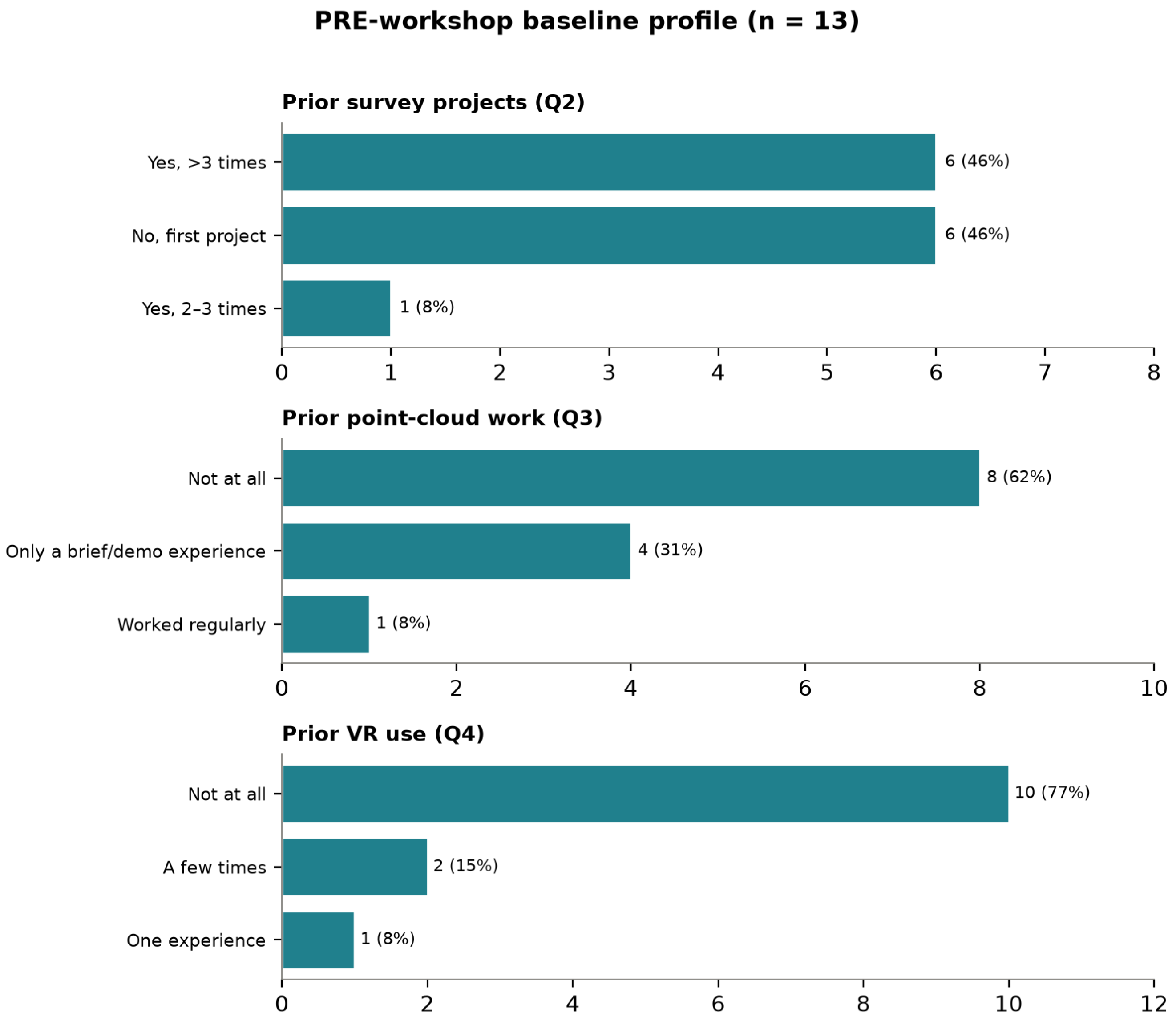
| General experience (EXP) | Q1–Q2 (study year, surveys history) (categorical, ) | Study years 3–6 plus one graduate (year 6 most frequent, 4/13). Prior survey projects polarised: 6/13 (46%) >3 projects, 6/13 (46%) first project, 1/13 (8%) 2–3 projects. |
| Point-cloud exposure (PC_EXP) | Q3 (prior point-cloud work) (categorical, ) | 8/13 (62%) no prior exposure; 4/13 (31%) brief/demo only; 1/13 (8%) worked regularly. |
| VR exposure (VR_EXP) | Q4 (educational/professional VR use) (categorical, ) | 10/13 (77%) no prior VR; 2/13 (15%) a few times; 1/13 (8%) once. |
| Technical competence 3D (IT3D) | Q5–Q9 (evaluation of point clouds and 3D tools) (Likert, ) | Understanding point clouds Q5 median 3 [2.5–4.0]; application examples Q6 median 2 [1.5–2.5]; comfort with 3D software Q7 median 3 [3.0–4.0]; expected difficulty Q8 median 3 [2.0–3.5]; expected future usefulness Q9 median 4 [4.0–5.0]. |
| Heritage sensitivity (SPV) | Q10–Q14 (heritage, values and expectations) (Likert, ) | Confidence identifying cultural values Q10 median 3 [2.0–3.5]; interest in Transylvanian sites Q13 median 4 [3.0–4.5]; belief that digital documentation protects heritage Q14 median 5 [5.0–5.0]. |
| Digital archive awareness (AD) | Q15–Q18 (archive, digital twin, VR expectations) (Likert, ) | Understanding digital archiving Q15 median 3 [2.5–4.0]; digital-twin concept Q16 median 2 [1.0–2.5]; curiosity about VR + point clouds Q18 median 5 [4.0–5.0]. |
| Motivation and concerns (MOT) | Q19–Q20 (open expectations and worries) (open, ) | Wishes to learn point-cloud processing, accurate 3D survey and BIM/HBIM integration; main concerns are the technical side, data volume/software performance and interpretation. |
| Indicator | Items (Post) | Observed Tendency (n = 13) |
|---|---|---|
| General experience and sites (EXP) | Q1–Q4 (study year, number of sites, overall experience) (categorical) | Predominantly year 5 (11/13). Most students worked on several project sites; overall real-project experience self-rated higher than at baseline. |
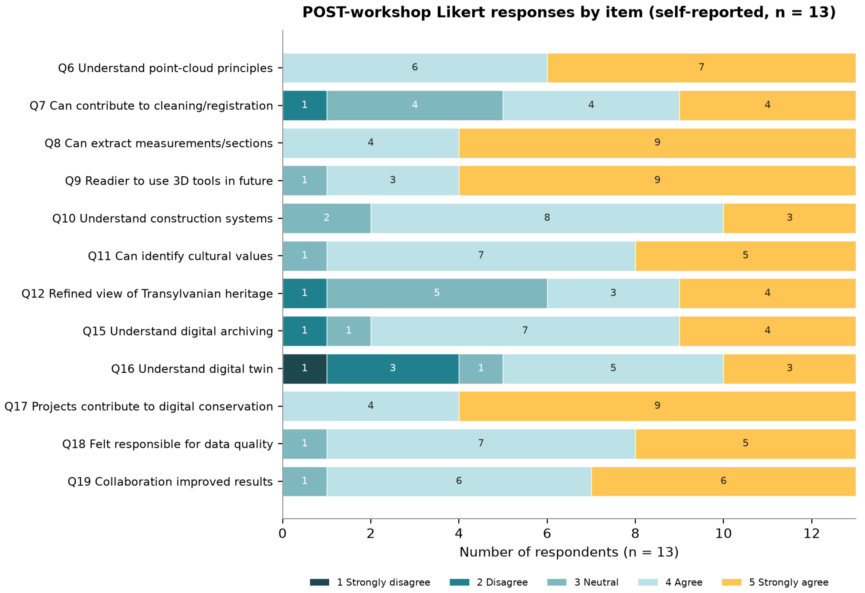
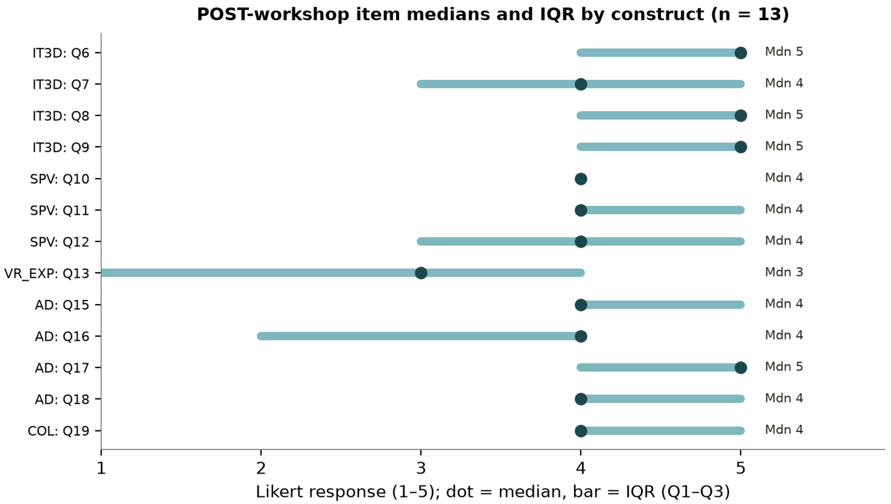
| Technical competence 3D (IT3D) | Q6–Q9 (point-cloud principles, cleaning/registration, measurement, future use) (Likert) | Understanding principles Q6 median 5 [4–5]; contribute to cleaning/registration Q7 median 4 [3–5]; extract measurements/sections Q8 median 5 [4–5]; readier for future use Q9 median 5 [4–5]. |
| Heritage understanding (SPV) | Q10–Q12 (construction systems, cultural values, refined view of heritage) (Likert) | Construction systems Q10 median 4 [4–4]; identify cultural values Q11 median 4 [4–5]; refined view of Transylvanian heritage Q12 median 4 [3–5]. |
| VR experience and impact (VR_EXP) | Q13–Q14 (VR use in heritage projects, impact on understanding) (Likert) | VR use Q13 median 3 [1–4] (uneven access; 6/13 rated 1–2); perceived VR impact Q14 median 5 [3.75–5.0] among the 8 who used VR. |
| Digital archive awareness (AD) | Q15–Q18 (digital archiving, digital twin, digital conservation, responsibility) (Likert) | Digital archiving Q15 median 4 [4–5]; digital-twin concept Q16 median 4 [2–4]; projects contribute to digital conservation Q17 median 5 [4–5]; responsibility for data quality Q18 median 4 [4–5]. |
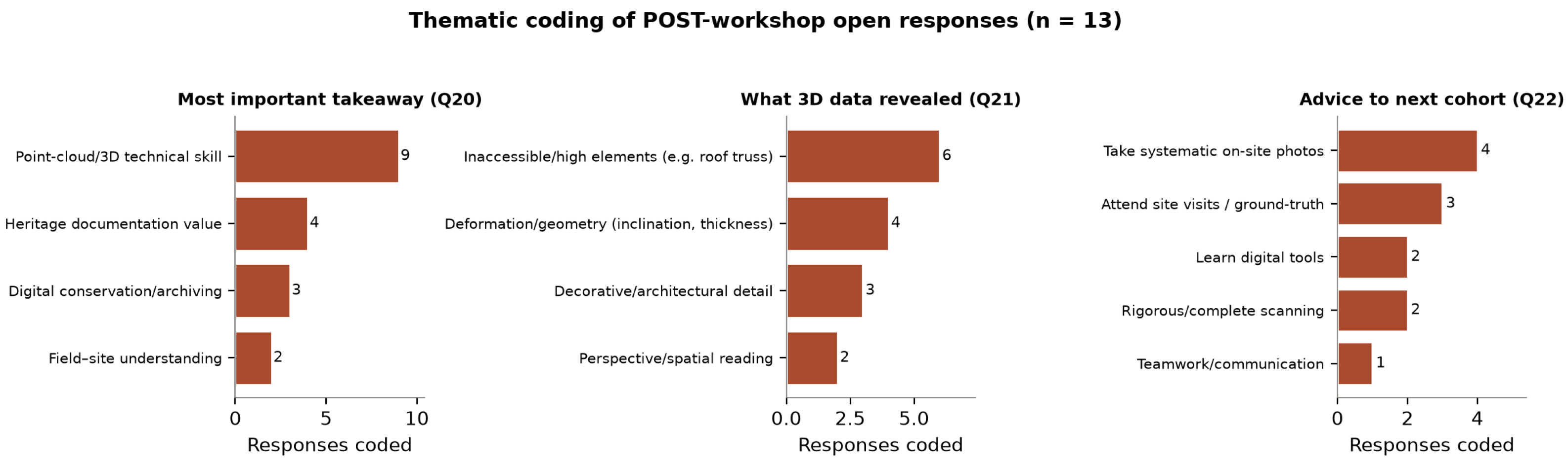
| Collaboration and agency (COL) | Q19 + Q20–Q22 (teamwork item and open reflections) (Likert + open) | Collaboration improved results Q19 median 4 [4–5]. Open responses position students as co-creators of a digital archive and stress systematic photography, site visits and complete scanning. |
Disclaimer/Publisher’s Note: The statements, opinions and data contained in all publications are solely those of the individual author(s) and contributor(s) and not of MDPI and/or the editor(s). MDPI and/or the editor(s) disclaim responsibility for any injury to people or property resulting from any ideas, methods, instructions or products referred to in the content. |
© 2026 by the authors. Licensee MDPI, Basel, Switzerland. This article is an open access article distributed under the terms and conditions of the Creative Commons Attribution (CC BY) license.
Share and Cite
Voinea, A.E.; Neamtu, C.; Pop, V. Sharing Cultural Values Through 3D Point-Cloud-Based Documentation of Transylvanian Heritage. Remote Sens. 2026, 18, 2841. https://doi.org/10.3390/rs18162841
Voinea AE, Neamtu C, Pop V. Sharing Cultural Values Through 3D Point-Cloud-Based Documentation of Transylvanian Heritage. Remote Sensing. 2026; 18(16):2841. https://doi.org/10.3390/rs18162841
Chicago/Turabian StyleVoinea, Alina Elena, Calin Neamtu, and Virgil Pop. 2026. "Sharing Cultural Values Through 3D Point-Cloud-Based Documentation of Transylvanian Heritage" Remote Sensing 18, no. 16: 2841. https://doi.org/10.3390/rs18162841
APA StyleVoinea, A. E., Neamtu, C., & Pop, V. (2026). Sharing Cultural Values Through 3D Point-Cloud-Based Documentation of Transylvanian Heritage. Remote Sensing, 18(16), 2841. https://doi.org/10.3390/rs18162841