Predicting LiDAR-Derived Canopy Leaf Area Index in Loblolly Pine Plantations with Sentinel-2 Imagery Using a Convolutional Neural Network Approach


Highlights
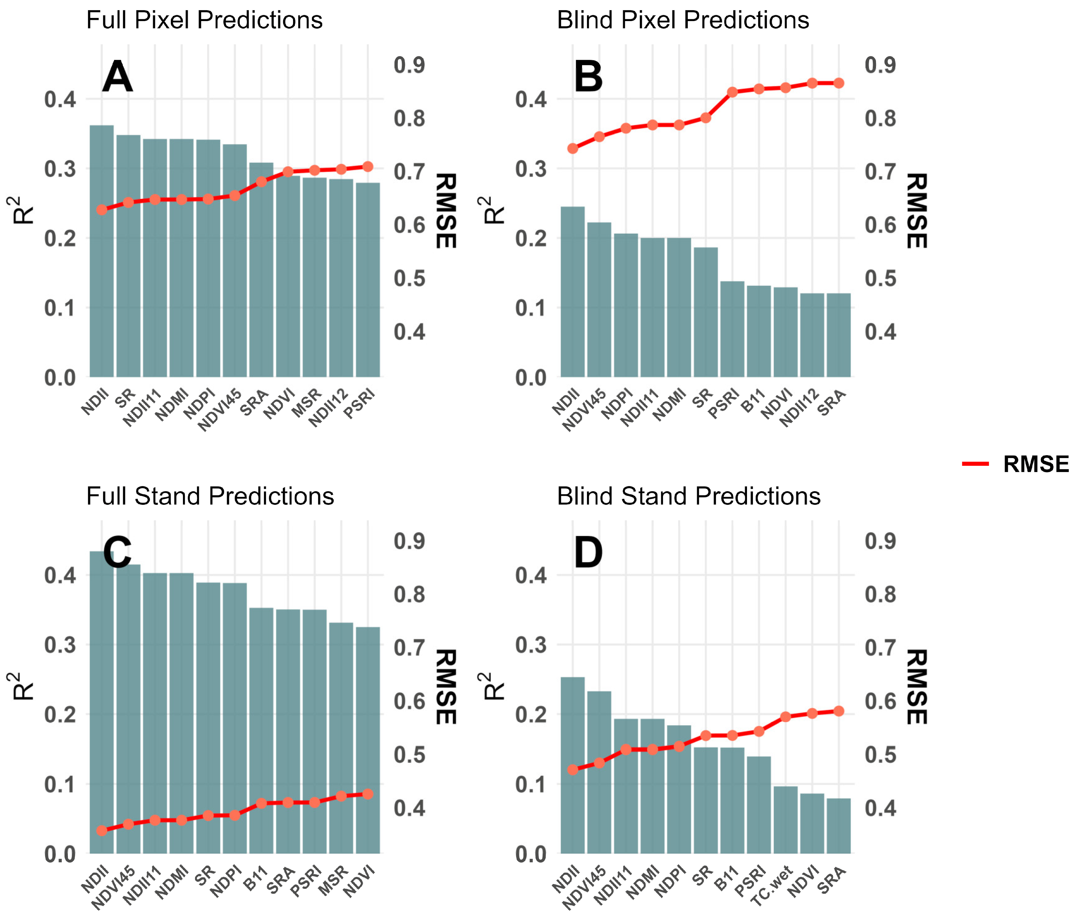
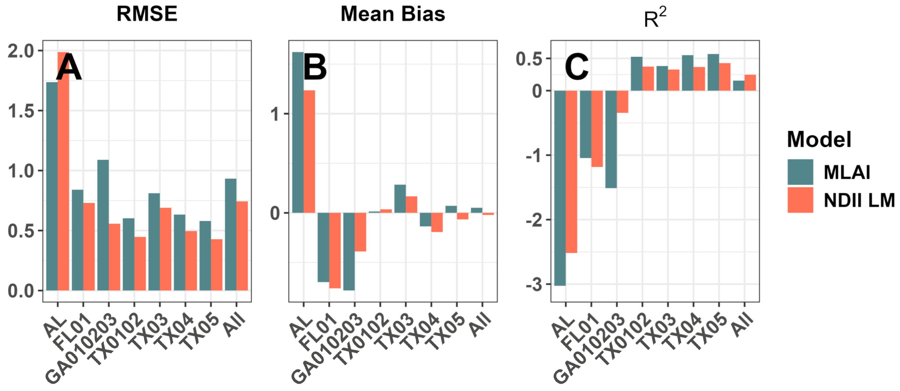
- A convolutional neural network (CNN) approach to predicting loblolly pine canopy Leaf Area Index (CLAI), trained on LiDAR-based retrievals and using Sentinel-2 multispectral imagery, performed better than traditional linear models based on vegetation indices.
- This model was less generalizable to unobserved spatial domains; in the general case, linear modeling approaches showed lower prediction error.
- A cloud-based CNN model trained on existing LiDAR-based CLAI retrievals can effectively close gaps between infrequent data acquisitions in intensive forestry.
- Additional work, and caution, is warranted in creating generalized models for estimating stand parameters more broadly.
Abstract
1. Introduction
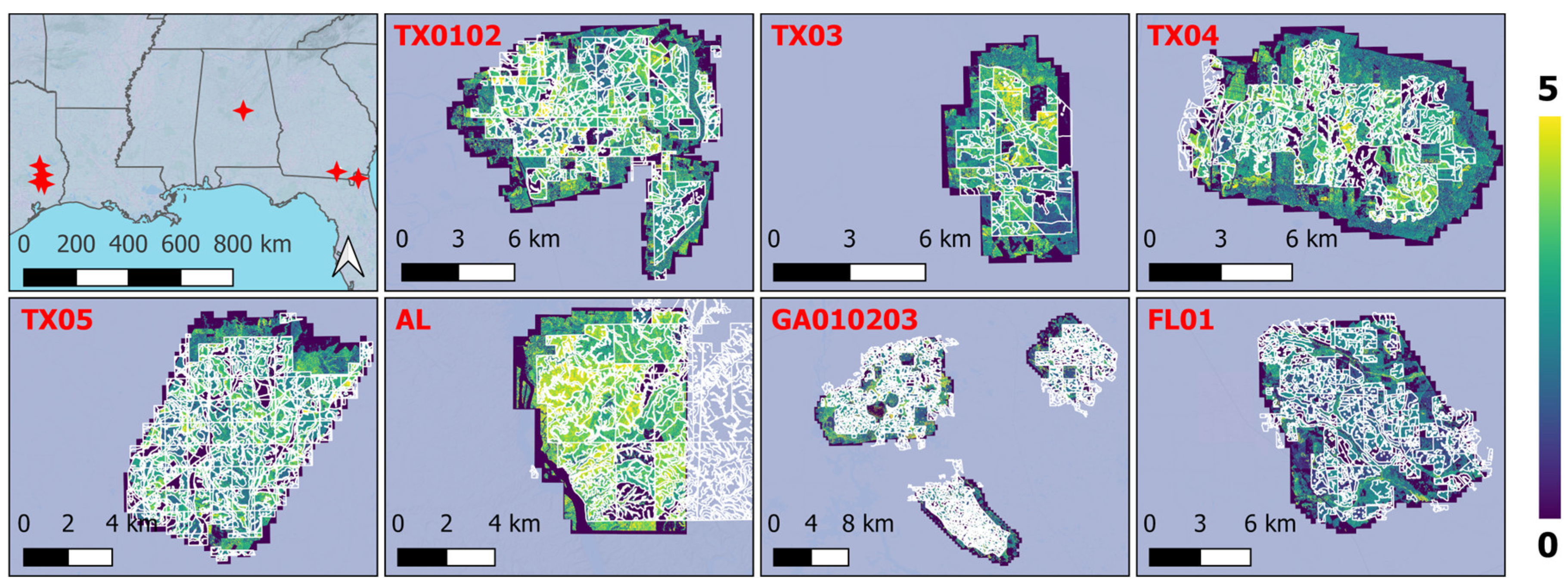
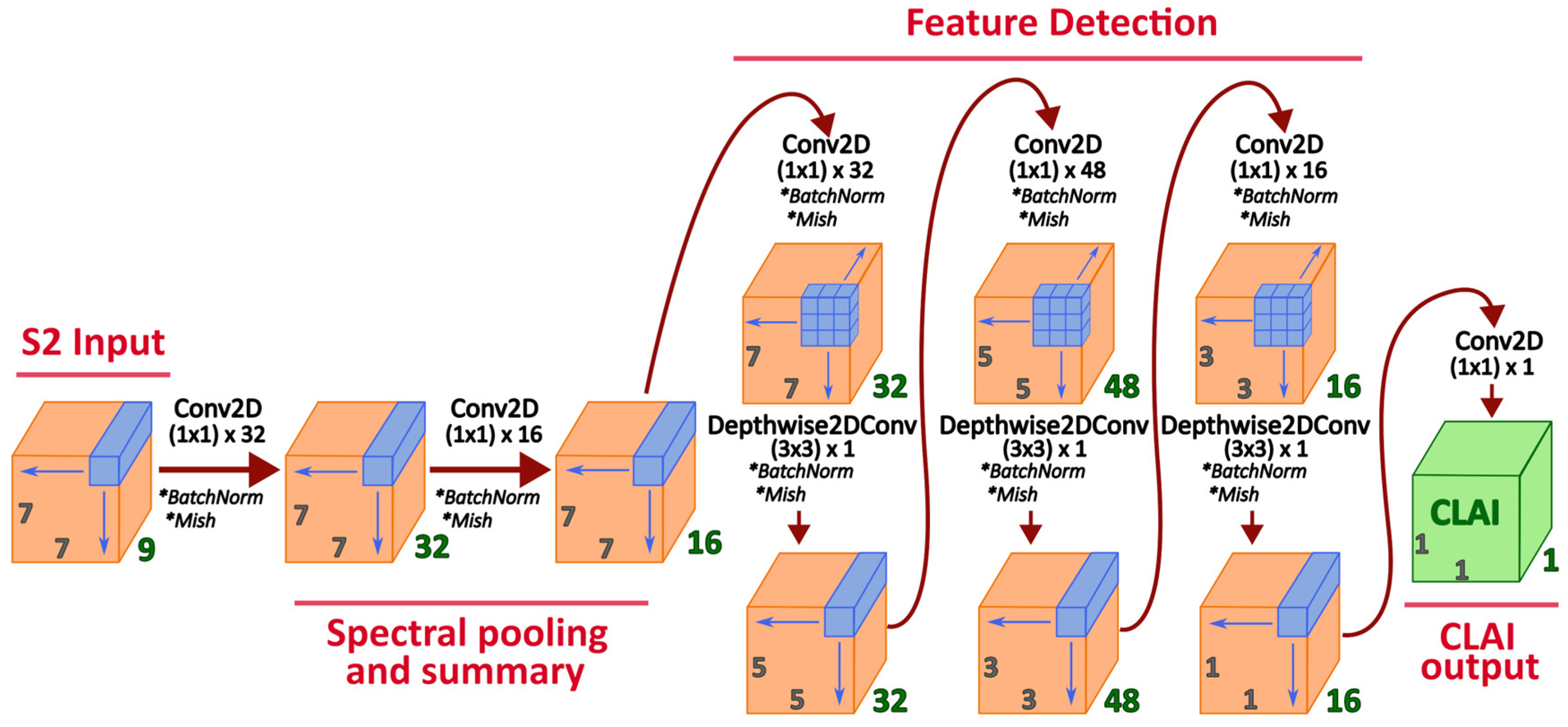
- We first demonstrate a CNN-based model (dubbed the “Machine Learning for Leaf Area Index”, MLAI) for pine plantations trained on a novel dataset of LiDAR-derived CLAI estimates for loblolly pine in the U.S. Southeast. This model uses Sentinel-2 L1C (top of atmosphere) multispectral data as its input and generates 10 m CLAI estimates for loblolly pine as an output. We then evaluate the predictive performance of the MLAI against traditional VI-based linear models.
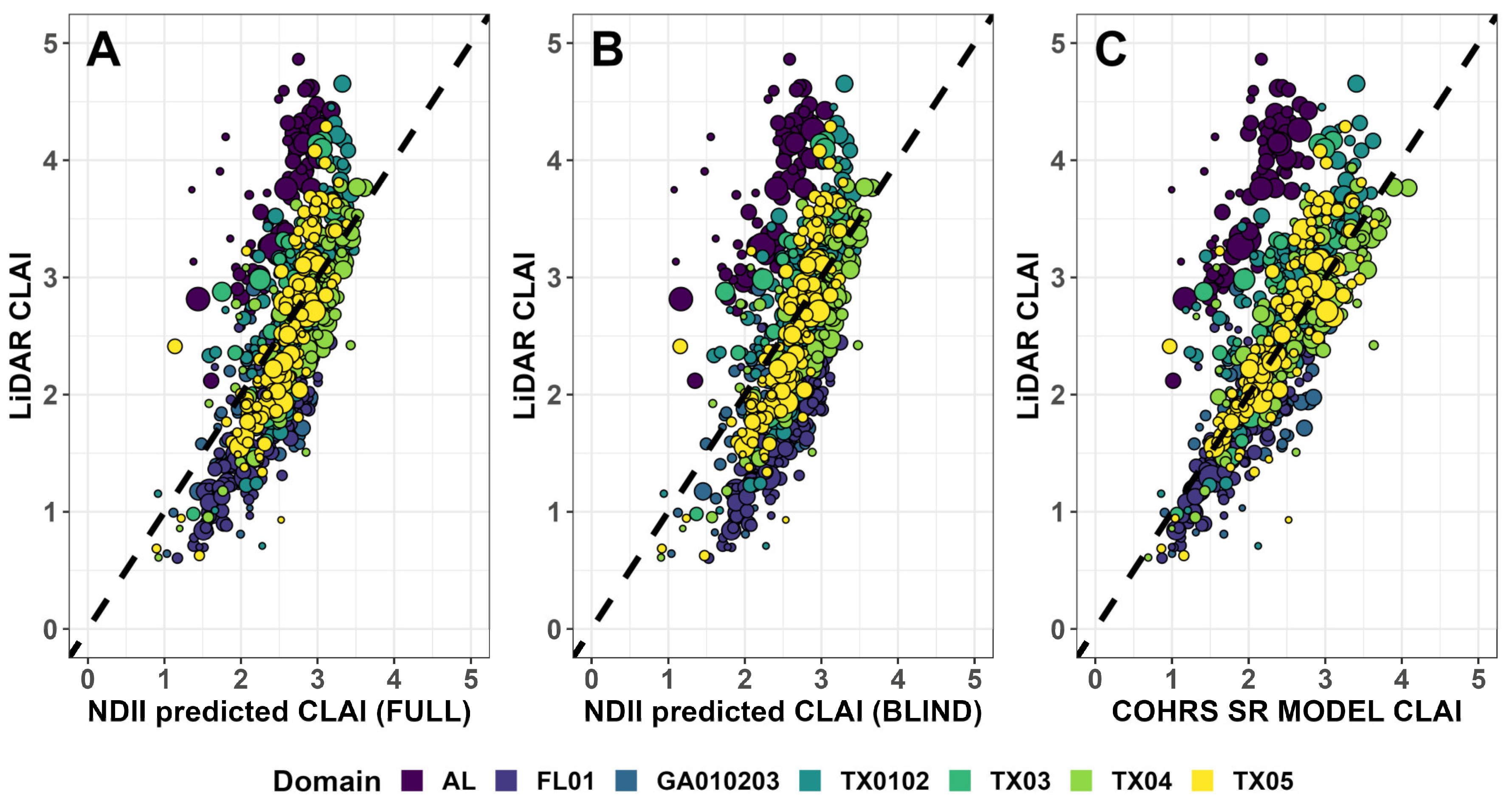
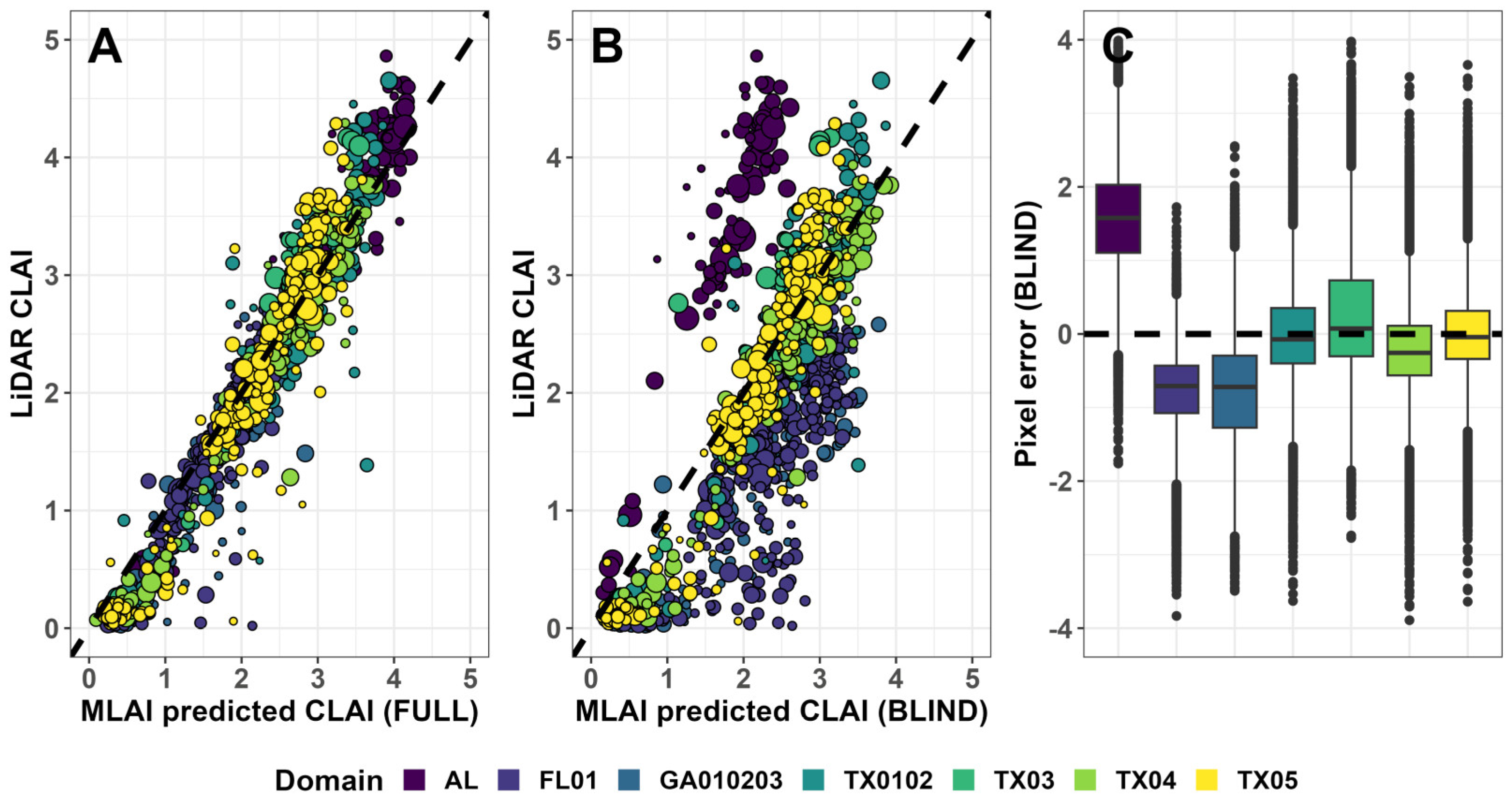
- Second, we probe the extent to which the MLAI trained on a relatively limited LiDAR-derived dataset can be generalized across space, time, and scan acquisition conditions. This test is accomplished first by evaluating prediction accuracy for “blind” models denied access to training data from each discrete LiDAR acquisition domain compared with a “full” model trained with data sampled from all LiDAR domains; and second by comparing MLAI predictions to CLAI retrievals derived from publicly available pointcloud data from LiDAR acquisitions over the past several years by the U.S. Geological Survey (USGS) over various parts of the continental U.S. containing loblolly pine plantations [45].
2. Materials and Methods
2.1. Aerial LiDAR-Based CLAI Estimates
2.2. Convolutional Neural Network Construction: Machine Learning for Leaf Area Index (MLAI)
2.3. MLAI Model Training and Prediction
2.4. Linear Model Fitting with Vegetation Indices
2.5. Evaluation of Model Prediction Quality
2.6. Evaluation of MLAI Performance Against Independent USGS LiDAR-Based Estimates
3. Results
3.1. MLAI Prediction Accuracy at Pixel- and Stand Scale
3.2. MLAI CLAI Predictions vs. USGS-LiDAR Derived Estimates
3.3. Relative Performance of Linear Regression Models Using VIs
4. Discussion
5. Conclusions
Supplementary Materials
Author Contributions
Funding
Data Availability Statement
Acknowledgments
Conflicts of Interest
Abbreviations
| CLAI/LAI | (Canopy) Leaf Area Index |
| CNN | Convolutional Neural Network |
| LiDAR | Light Detection and Ranging |
| MLAI | Machine Learning for Leaf Area Index |
| NIR/SWIR | Near-Infrared/Shortwave Infrared |
| RMSE | Root Mean Squared Error |
| USGS | United States Geological Survey |
| VI | Vegetation Index |
References
- Parker, G.G. Tamm Review: Leaf Area Index (LAI) Is Both a Determinant and a Consequence of Important Processes in Vegetation Canopies. For. Ecol. Manag. 2020, 477, 118496. [Google Scholar] [CrossRef] [Scilit]
- Fox, T.R.; Allen, H.L.; Albaugh, T.J.; Rubilar, R.; Carlson, C.A. Tree Nutrition and Forest Fertilization of Pine Plantations in the Southern United States. South. J. Appl. For. 2007, 31, 5–11. [Google Scholar] [CrossRef] [Scilit]
- Luo, Y.; Medlyn, B.; Hui, D.; Ellsworth, D.; Reynolds, J.; Katul, G. Gross Primary Productivity in Duke Forest: Modeling Synthesis of CO2 Experiment and Eddy-Flux Data. Ecol. Appl. 2001, 11, 239–252. [Google Scholar] [CrossRef] [Scilit]
- Vose, J.M.; Allen, H.L. Leaf Area, Stemwood Growth, and Nutrition Relationships in Loblolly Pine. For. Sci. 1988, 34, 546–563. [Google Scholar] [CrossRef] [Scilit]
- Bi, W.; He, W.; Zhou, Y.; Ju, W.; Liu, Y.; Zhang, X.; Wei, X.; Cheng, N. A Global 0.05° Dataset for Gross Primary Production of Sunlit and Shaded Vegetation Canopies from 1992 to 2020. Sci. Data 2022, 9, 233. [Google Scholar] [CrossRef] [Scilit] [PubMed]
- Mahadevan, P.; Wofsy, W.C.; Matross, D.M.; Xiao, X.; Dunn, A.L.; Lin, J.C.; Gerbig, C.; Munger, J.W.; Chow, V.Y.; Gottlieb, E.W. A Satellite-Based Biosphere Parameterization for Net Ecosystem CO2 Exchange: Vegetation Photosynthesis and Respiration Model (VPRM). Glob. Biogeochem. Cycles 2008, 22, 2005. [Google Scholar] [CrossRef] [Scilit]
- Cohrs, C.W.; Lyons, A.; Albaugh, T.J.; Carter, D.R.; Campoe, O.C.; Rubilar, R.A.; Sumnall, M.; Trlica, A.; Corrao, M.V.; Virk, S.; et al. Precision Forestry in Actively Managed Loblolly Pine Plantations: Leaf Area Index Response One Growing Season Following a Variable-Rate Fertilization. For. Ecol. Manag. 2025, 595, 122989. [Google Scholar] [CrossRef] [Scilit]
- House, M.N.; Wynne, R.H.; Thomas, V.A.; Cook, R.L.; Carter, D.R.; Mullekom, J.H.; Rakestraw, J.; Schroeder, T.A. Effects of establishment fertilization on Landsat-assessed leaf area development of loblolly pine stands. For. Ecol. Manag. 2024, 556, 121655. [Google Scholar] [CrossRef] [Scilit]
- Cañete-Salinas, P.; Zamudio, F.; Yáñez, M.; Gajardo, J.; Valdés, H.; Espinosa, C.; Venegas, J.; Retamal, L.; Ortega-Farias, S.; Acevedo-Opazo, C. Evaluation of Models to Determine LAI on Poplar Stands Using Spectral Indices from Sentinel-2 Satellite Images. Ecol. Model. 2020, 428, 109058. [Google Scholar] [CrossRef] [Scilit]
- Viña, A.; Gitelson, A.A.; Nguy-Robertson, A.L.; Peng, Y. Comparison of Different Vegetation Indices for the Remote Assessment of Green Leaf Area Index of Crops. Remote Sens. Environ. 2011, 115, 3468–3478. [Google Scholar] [CrossRef] [Scilit]
- Blinn, C.E.; House, M.N.; Wynne, R.H.; Thomas, V.A.; Fox, T.R.; Sumnall, M. Landsat 8 based leaf area index estimation in loblolly pine plantations. Forests 2019, 10, 222. [Google Scholar] [CrossRef] [Scilit]
- Cohrs, C.W.; Cook, R.L.; Gray, J.M.; Albaugh, T.J. Sentinel-2 Leaf Area Index Estimation for Pine Plantations in the Southern United States. Remote Sens. 2020, 12, 1406. [Google Scholar] [CrossRef] [Scilit]
- Kinane, S.M.; Montes, C.R.; Albaugh, T.J.; Mishra, D.R. A model to estimate leaf area index in loblolly pine plantations using Landsat 5 and 7 images. Remote Sens. 2021, 13, 1140. [Google Scholar] [CrossRef] [Scilit]
- Bréda, N.J.J. Ground-Based Measurements of Leaf Area Index: A Review of Methods, Instruments and Current Controversies. J. Exp. Bot. 2003, 54, 2403–2417. [Google Scholar] [CrossRef] [Scilit] [PubMed]
- Kira, O.; Nguy-Robertson, A.L.; Arkebauer, T.J.; Linker, R.; Gitelson, A.A. Informative Spectral Bands for Remote Green LAI Estimation in C4 and C4 Crops. Agric. For. Meteorol. 2016, 218–219, 243–249. [Google Scholar] [CrossRef] [Scilit]
- Xue, J.; Su, B. Significant Remote Sensing Vegetation Indices: A Review of Developments and Applications. J. Sens. 2017, 2017, 1353691. [Google Scholar] [CrossRef] [Scilit]
- Lunetta, R.S.; Congalton, R.G.; Fenstermaker, L.; Jensen, J.R.; McGwire, K.C.; Tinney, L.R. Remote Sensing and Geographic Information System Data Integration: Error Sources and Research Issues. Photogramm. Eng. Remote Sens. 1991, 57, 677–687. [Google Scholar]
- Roy, D.P.; Zhang, H.K.; Ju, J.; Gomez-Dans, J.L.; Lewis, P.E.; Schaaf, C.B.; Sun, Q.; Li, J.; Huang, H.; Kovalskyy, V. A general method to normalize Landsat reflectance to nadir BDRF adjusted reflectance. Remote Sens. Environ. 2016, 176, 255–271. [Google Scholar] [CrossRef] [Scilit]
- Peduzzi, A.; Allen, H.L.; Wynne, R.H. Leaf Area of Overstory and Understory in Pine Plantations in the Flatwoods. South. J. Appl. For. 2010, 34, 154–160. [Google Scholar] [CrossRef] [Scilit]
- Verrelst, J.; Camps-Valls, G.; Muñoz-Marí, J.; Rivera, J.P.; Veroustraete, F.; Clevers, J.G.P.W.; Moreno, J. Optical Remote Sensing and the Retrieval of Terrestrial Vegetation Bio-Geophysical Properties—A Review. ISPRS J. Photogramm. Remote Sens. 2015, 108, 273–290. [Google Scholar] [CrossRef] [Scilit]
- Houborg, R.; McCabe, M.F. A Hybrid Training Approach for Leaf Area Index Estimation via Cubist and Random Forests Machine-Learning. ISPRS J. Photogramm. Remote Sens. 2018, 135, 173–188. [Google Scholar] [CrossRef] [Scilit]
- Zhang, Z.; Xin, Q.; Li, W. Machine Learning-Based Modeling of Vegetation Leaf Area Index and Gross Primary Productivity across North America and Comparison with a Process-Based Model. J. Adv. Model. Earth Syst. 2021, 13, e2021MS002802. [Google Scholar] [CrossRef] [Scilit]
- Chen, L.; Ren, C.; Zhang, B.; Wang, Z.; Xi, Y. Estimation of Forest Above-Ground Biomass by Geographically Weighted Regression and Machine Learning with Sentinel Imagery. Forests 2018, 9, 582. [Google Scholar] [CrossRef] [Scilit]
- Weis, M.; Baret, F. S2ToolBox Level 2 Products: LAI, FAPAR, FCOVER, version 1.1. 2016. Available online: http://step.esa.int/docs/extra/ATBD_S2ToolBox_L2B_V1.1.pdf (accessed on 1 December 2020).
- Gao, S.; Zhong, R.; Yan, K.; Ma, X.; Chen, X.; Pu, J.; Gao, S.; Qi, J.; Yin, G.; Myneni, R.B. Evaluating the Saturation Effect of Vegetation Indices in Forests Using 3D Radiative Transfer Simulations and Satellite Observations. Remote Sens. Environ. 2023, 295, 113665. [Google Scholar] [CrossRef] [Scilit]
- Huete, A.R.; Liu, H.Q.; Leeuwen, W.J.D. The Use of Vegetation Indies in Forested Regions: Issues of Linearity and Saturation. In Proceedings of the IGARSS’97, 1997 IEEE International Geoscience and Remote Sensing Symposium Proceedings. Remote Sensing—A Scientific Vision for Sustainable Development, Singapore, 3–8 August 1997; Volume 4, pp. 1966–1968. [Google Scholar] [CrossRef] [Scilit]
- Mas, J.F.; Flores, J.J. The Application of Artificial Neural Networks to the Analysis of Remotely Sensed Data. Int. J. Remote Sens. 2008, 29, 617–633. [Google Scholar] [CrossRef] [Scilit]
- Wang, Y.; Kukko, A.; Hyyppä, E.; Pyörälä, J.; Lehtomäki, M.; Issaoui, A.E.; Yu, X.; Kaartinen, H.; Liang, X.; Hyyppä, J. Seamless Integration of Above- and under-Canopy Unmanned Aerial Vehicle Laser Scanning for Forest Investigation. For. Ecosyst. 2021, 8, 10. [Google Scholar] [CrossRef] [Scilit]
- Hyyppä, J.; Hyyppä, H.; Litkey, P.; Yu, X.; Haggrén, H.; Rönnholm, P.; Pyysalo, U.; Pitkänen, J.; Maltamo, M. Algorithms and Methods of Airborne Laser Scanning for Forest Measurements. In Proceedings of the Laser-Scanners for Forest and Landscape Assessment—Instruments, Processing Methods, and Applications; Koch, B., Spiecker, H., Weinacker, H., Eds.; International Society for Photogrammetry and Remote Sensing: Hannover, Germany, 2004; pp. 82–89. [Google Scholar]
- White, J.C.; Coops, N.C.; Wulder, M.A.; Vastraranta, M.; Hilker, T.; Tompalski, P. Remote Sensing Technologies for Enhancing Forest Inventories: A Review. Can. J. Remote Sens. 2016, 42, 619–641. [Google Scholar] [CrossRef] [Scilit]
- Wang, Y.; Fang, H. Estimation of LAI with LiDAR Technology: A Review. Remote Sens. 2020, 12, 3457. [Google Scholar] [CrossRef] [Scilit]
- Ribas-Costa, V.; Gastón-Gonzáles, A.; Bloszies, S.A.; Henderson, J.D.; Trlica, A.; Carter, D.R.; Rubilar, R.A.; Campoe, O.C.; Albaugh, T.J.; Cook, R.L. Nature vs. Nurture: Drivers of Site Productivity in Loblolly Pine (Pinus taeda L.) Forests in the Southeastern U.S. For. Ecol. Manag. 2024, 572, 122334. [Google Scholar] [CrossRef] [Scilit]
- Sumnall, M.J.; Trlica, A.; Carter, D.R.; Cook, R.L.; Schulte, M.L.; Campoe, O.C.; Rubilar, R.A.; Wynne, R.H.; Thomas, V.A. Estimating the Overstory and Understory Vertical Extents and Their Leaf Area Index in Intensively Managed Loblolly Pine (Pinus taeda L.) Plantations Using Airborne Laser Scanning. Remote Sens. Environ. 2021, 254, 112250. [Google Scholar] [CrossRef] [Scilit]
- Sumnall, M.J.; Albaugh, T.J.; Carter, D.R.; Cook, R.L.; Hession, W.C.; Campoe, O.C.; Rubilar, R.A.; Wynne, R.H.; Thomas, V.A. Estimation of individual stem volume and diameter from segmented UAV laser scanning datasets in Pinus taeda L. plantations. Int. J. Remote Sens. 2023, 44, 217–247. [Google Scholar] [CrossRef] [Scilit]
- Silva, C.A.; Hudak, A.T.; Vierling, L.A.; Klauberg, C.; Garcia, M.; Ferraz, A.; Keller, M.; Eitel, J.; Saatchi, S. Impacts of Airborne Lidar Pulse Density on Estimating Biomass Stocks and Changes in a Selectively Logged Tropical Forest. Remote Sens. 2017, 9, 1068. [Google Scholar] [CrossRef] [Scilit]
- van Lier, O.R.; Luther, J.E.; White, J.C.; Fournier, R.A.; Côté, J.-F. Effect of Scan Angle on ALS Metrics and Area-Based Predictions of Forest Attributes for Balsam Fir Dominated Stands. For. Int. J. For. Res. 2022, 95, 49–72. [Google Scholar] [CrossRef] [Scilit]
- Watt, M.S.; Adams, T.; Aracil, S.G.; Mashall, H.; Watt, P. The Influence of LiDAR Pulse Density and Plot Size on the Accuracy of New Zealand Plantation Stand Volume Equations. N. Z. J. For. Sci. 2013, 43, 15. [Google Scholar] [CrossRef] [Scilit]
- Yao, W.; Krull, J.; Krzystek, P.; Heurich, M. Sensitivity Analysis of 3D Individual Tree Detection from LiDAR Point Clouds of Temperate Forests. Forests 2014, 5, 1122–1142. [Google Scholar] [CrossRef] [Scilit]
- Zhao, K.; Popescu, S. Lidar-Based Mapping of Leaf Area Index and Its Use for Validation GLOBCARBON Satellite LAI Product in a Temperate Forest of the Southern USA. Remote Sens. Environ. 2009, 113, 1628–1645. [Google Scholar] [CrossRef] [Scilit]
- Rahimzadeh-Bajgiran, P.; Hennigar, C.; Weiskittel, A.; Lamb, S. Forest Potential Productivity Mapping by Linking Remote-Sensing-Derived Metrics to Site Variables. Remote Sens. 2020, 12, 2056. [Google Scholar] [CrossRef] [Scilit]
- Chang, T.; Rasmussen, B.P.; Dickson, B.G.; Zachmann, L.J. Chimera: A Multi-Task Recurrent Convolutional Neural Network for Forest Classification and Structural Estimation. Remote Sens. 2019, 11, 768. [Google Scholar] [CrossRef] [Scilit]
- Thomas, V.A.; Wynne, R.H.; Kauffman, J.; McCurdy, W.; Brooks, E.B.; Thomas, R.Q.; Rakestraw, J. Mapping Thins to Identify Active Forest Management in Southern Pine Plantations Using Landsat Time Series Stacks. Remote Sens. Environ. 2021, 252, 112127. [Google Scholar] [CrossRef] [Scilit]
- Gavrilov, A.D.; Jordache, A.; Vasdani, M.; Deng, J. Preventing Overfitting and Underfitting in Convolutional Neural Networks. Int. J. Softw. Sci. Comput. Intell. 2018, 10, 19–28. [Google Scholar] [CrossRef] [Scilit]
- Amani, M.; Ghorbanian, A.; Ahmadi, S.A.; Kakooei, M.; Moghimi, A.; Mirmazloumi, S.M.; Moghaddam, S.H.A.; Mahdavi, S.; Ghahremanloo, M.; Parsian, S.; et al. Google Earth Engine Cloud Computing Platform for Remote Sensing Big Data Applications: A Comprehensive Review. IEEE J. Sel. Top. Appl. Earth Obs. Remote Sens. 2020, 13, 5326–5350. [Google Scholar] [CrossRef] [Scilit]
- Ribas-Costa, V.A.; Gastón, A.; Cook, R.L. Modelling Dominant Height with USGS 3DEP LiDAR to Determine Site Index in Even-Aged Loblolly Pine Plantations in the Southeastern US. For. Int. J. For. Res. 2024, 98, cpae034. [Google Scholar] [CrossRef] [Scilit]
- Raigosa-García, I.; Rathbun, L.C.; Cook, R.L.; Baker, J.S.; Corrao, M.V.; Sumnall, M.J. Rethinking Productivity Evaluation in Precision Forestry through Dominant Height and Site Index Measurements Using Aerial Laser Scanning LiDAR Data. Forests 2024, 15, 1002. [Google Scholar] [CrossRef] [Scilit]
- Misra, D. Mish: A Self-Regularized Non-Monotonic Activation Function. arXiv 2020, arXiv:1908.08681. [Google Scholar]
- Skakun, S.; Wevers, J.; Brockmann, C.; Doxani, G.; Aleksandrov, M.; Batič, M.; Franz, D.; Gascon, F.; Gómez-Chova, L.; Hagolle, O.; et al. Cloud Mask Intercomparison eXercise (CMIX): An Evaluation of Cloud Masking Algorithms for Landsat 8 and Sentinel-2. Remote Sens. Environ. 2022, 274, 112990. [Google Scholar] [CrossRef] [Scilit]
- Zupenc, A. Improving Cloud Detection with Machine Learning. 2017, 10, 2019. Available online: https://medium.com/sentinel-hub/improving-cloud-detection-with-machine-learning-c09dc5d7cf13 (accessed on 1 July 2025).
- Louis, J.; Pflug, B.; Main-Knorn, M.; Debaeker, V.; Mueller-Wilm, U.; Iannone, R.Q. Sentinel-2 Global Surface Reflectance Level-2a Product Generated with Sen2Cor. In Proceedings of the IGARSS 2019—2019 IEEE International Geoscience and Remote Sensing Symposium, Yokohama, Japan, 28 July–2 August 2019; pp. 8522–8525. [Google Scholar]
- Bhattarai, R.; Rahimzadeh-Bajgiran, P.; Weiskittel, A.; Homayouni, S.; Gara, T.W.; Hanavan, R.P. Estimating Species-Specific Leaf Area Index and Basal Area Using Optical and SAR Remote Sensing Data in Acadian Mixed Spruce-Fir Forests, USA. Int. J. Appl. Earth Obs. Geoinf. 2022, 108, 102727. [Google Scholar] [CrossRef] [Scilit]
- Shi, T.; Xu, H. Derivation of Tasseled Cap Transformation Coefficients for Sentinel-2 MSI at-Sensor Reflectance Data. IEEE J. Sel. Top. Earth Obs. Remote Sens. 2019, 12, 4038–4048. [Google Scholar] [CrossRef] [Scilit]
- R Core Team. R: A Language and Environment for Statistical Computing; R Foundation for Statistical Computing: Vienna, Austria, 2024. [Google Scholar]
- Wickham, H.; François, R.; Henry, L.; Müller, K.; Vaughan, D. dplyr: A Grammar of Data Manipulation 2023. Available online: https://CRAN.R-project.org/package=dplyr (accessed on 1 December 2020).
- Barrett, T.; Dowle, M.; Gorecki, J.; Chirico, M.; Hocking, T.; Schwendinger, B. Data.Table: Extension of “Data.Frame”, version 1.16.4. 2024. Available online: https://CRAN.R-project.org/package=data.table (accessed on 1 December 2020).
- Hijmans, R. terra: Spatial Data Analysis 2025. Available online: https://CRAN.R-project.org/package=terra (accessed on 1 December 2020).
- Pebesma, E. Simple Features for R: Standardized Support for Spatial Vector Data. R J. 2018, 10, 439–446. [Google Scholar] [CrossRef] [Scilit]
- Pebesma, E.; Bivand, R. Spatial Data Science: With Applications in R; Chapman and Hall/CRC: Boca Raton, FL, USA, 2023. [Google Scholar] [CrossRef] [Scilit]
- Baston, D. Exactextractr: Fast Extraction from Raster Datasets Using Polygons 2023. Available online: https://CRAN.R-project.org/package=exactextractr (accessed on 1 December 2020).
- Wickham, H. ggplot2: Elegant Graphics for Data Analysis; Springer: New York, NY, USA, 2016. [Google Scholar]
- U.S. Geological Survey USGS 3D Elevation Program Digital Elevation Model. Available online: https://elevation.nationalmap.gov/arcgis/rest/services/3DEPElevation/ImageServer (accessed on 15 June 2023).
- Fensholt, R.; Sandholt, I. Derivation of a Shortwave Infrared Water Stress Index from MODIS Near- and Shortwave Infrared Data in a Semiarid Environment. Remote Sens. Environ. 2003, 87, 111–121. [Google Scholar] [CrossRef] [Scilit]
- Flores, F.J.; Allen, H.L.; Cheshire, H.M.; Davis, J.M.; Fuentes, M.; Kelting, D. Using Multispectral Satellite Imagery to Estimate Leaf Area and Response to Silvicultural Treatments in Loblolly Pine Stand. Can. J. For. Res. 2006, 36, 1587–1596. [Google Scholar] [CrossRef] [Scilit]
- Ge, S.; Antropov, O.; Häme, T.; McRoberts, R.E.; Miettinen, J. Deep Learning Model Transfer in Forest Mapping Using Multi-Source Satellite SAR and Optical Images. Remote Sens. 2023, 15, 5152. [Google Scholar] [CrossRef] [Scilit]
- Gazzea, M.; Solheim, A.; Arghandeh, R. High-Resolution Mapping of Forest Structure from Integrated SAR and Optical Images Using an Enhanced U-Net Method. Sci. Remote Sens. 2023, 8, 100093. [Google Scholar] [CrossRef] [Scilit]
- Lang, N.; Jetz, W.; Schindler, K.; Wegner, J.D. Forest Canopy Height Mapping at Global Scale by Fusing Sentinel-2 and GEDI. In Proceedings of the Living Planet Symposium, Bonn, Germany, 23–27 May 2022; Nature Ecology & Evolution: London, UK, 2023. [Google Scholar]
- Guo, Y.; Li, Z.; Chen, E.; Zhang, X.; Zhao, L.; Xu, E.; Hou, Y.; Liu, L. A Deep Fusion uNet for Mapping Forest at Tree Species Levels with Multi-Temporal High Spatial Resolution Satellite Imagery. Remote Sens. 2021, 13, 3613. [Google Scholar] [CrossRef] [Scilit]
- John, D.; Zhang, C. An Attention-Based U-Net for Detecting Deforestation within Satellite Sensor Imagery. Int. J. Appl. Earth Obs. Geoinf. 2022, 107, 102685. [Google Scholar] [CrossRef] [Scilit]
- Pyo, J.; Han, K.; Cho, Y.; Kim, D.; Jin, D. Generalization of U-Net Semantic Segmentation for Forest Change Detection in South Korea Using Airborne Imagery. Forests 2022, 13, 2170. [Google Scholar] [CrossRef] [Scilit]
- Shi, Z.; Shi, S.; Gong, W.; Xu, L.; Wang, B.; Sun, J.; Chen, B.; Xu, Q. LAI Estimation Based on Physical Model Combining Airborne LiDAR Waveform and Sentinel-2 Imagery. Front. Plant Sci. 2023, 14, 1237988. [Google Scholar] [CrossRef] [Scilit] [PubMed]
- Vafaei, S.; Fathizadeh, O.; Puletti, N.; Fadaei, H.; Baqer Rasooli, S.; Vaglio Laurin, G. Estimation of Forest Leaf Area Index Using Satellite Multispectral and Synthetic Aperture Radar Data in Iran. iForest-Biogeosciences For. 2021, 14, 278. [Google Scholar] [CrossRef] [Scilit]
- Seyrek, E.C.; Narin, O.G.; Uysal, M. Forest Canopy Cover Estimation with Machine Learning Using GEDI and Landsat Data in the Western Marmara Region, Türkiye. Earth Sci. Inf. 2025, 18, 230. [Google Scholar] [CrossRef] [Scilit]
- He, K.; Zhang, X.; Ren, S.; Sun, J. Deep Residual Learning for Image Recognition. In Proceedings of the IEEE Conference on Computer Vision and Pattern Recognition, Las Vegas, NV, USA, 27–30 June 2016; pp. 770–778. [Google Scholar]
- Al-Emadi, S.A.; Yang, Y.; Ofli, F. Analysing Satellite Imagery Classification under Spatial Domain Shift across Geographic Regions. Int. J. Comput. Vis. 2025, 133, 7672–7709. [Google Scholar] [CrossRef] [Scilit]
- Smith, H.D.; Dubeux, J.C.B.; Zare, A.; Wilson, C.H. Assessing Transferability of Remote Sensing Pasture Estimates Using Multiple Machine Learning Algorithms and Evaluation Structures. Remote Sens. 2023, 15, 2940. [Google Scholar] [CrossRef] [Scilit]
- Geman, S.; Bienenstock, E.; Doursat, R. Neural Networks and the Bias/Variance Dilemma. Neural Comput. 1992, 4, 1–58. [Google Scholar] [CrossRef] [Scilit]
- Boyd, D.S.; Wicks, T.E.; Curran, P.J. Use of Middle Infrared Radiation to Estimate the Leaf Area Index of a Boreal Forest. Tree Physiol. 2000, 20, 755–760. [Google Scholar] [CrossRef] [Scilit] [PubMed]
- Foody, G.M. Status of Land Cover Classification Accuracy Assessment. Remote Sens. Environ. 2002, 80, 185–201. [Google Scholar] [CrossRef] [Scilit]
- Frenay, B.; Verleysen, M. Classification in the Presence of Label Noise: A Survey. IEEE Trans. Neural Netw. Learn. Syst. 2014, 25, 845–869. [Google Scholar] [CrossRef] [Scilit] [PubMed]
- Song, H.; Kim, M.; Park, D.; Shin, Y.; Lee, J.-G. Learning from Noisy Labels with Deep Neural Networks: A Survey. IEEE Trans. Neural Netw. Learn. Syst. 2022, 34, 8135–8153. [Google Scholar] [CrossRef] [Scilit] [PubMed]
- Northcutt, C.; Jiang, L.; Chuang, I. Confident Learning: Estimating Uncertainty in Dataset Labels. J. Artif. Intell. Res. 2021, 70, 1373–1411. [Google Scholar] [CrossRef] [Scilit]
- Sumnall, M.J.; Albaugh, T.J.; Carter, D.R.; Cook, R.L.; Hession, W.C.; Campoe, O.C.; Wynne, R.H.; Thomas, V.A. Effect of Varied Unmanned Aerial Vehicle Laser Scanning Pulse Density on Accurately Quantifying Forest Structure. Int. J. Remote Sens. 2022, 43, 721–750. [Google Scholar] [CrossRef] [Scilit]
- Schlerf, M.; Atzberger, C.; Hill, J. Remote Sensing of Forest Biophysical Variables Using HyMap Imaging Spectrometer Data. Remote Sens. Environ. 2005, 95, 177–194. [Google Scholar] [CrossRef] [Scilit]
- Huang, T.; Ou, G.; Xu, H.; Zhang, X.; Wu, Y.; Liu, Z.; Zou, F.; Zhang, C.; Xu, C. Comparing Algorithms for Estimation of Aboveground Biomass in Pinus Yunnanensis. Forests 2023, 14, 1742. [Google Scholar] [CrossRef] [Scilit]
- Ma, X.; Huete, A.; Tran, N.N.; Bi, J.; Gao, S.; Zeng, Y. Sun-Angle Effects on Remote-Sensing Phenology Observed and Modelled Using Himawari-8. Remote Sens. 2020, 12, 1339. [Google Scholar] [CrossRef] [Scilit]





| Domain | No. Stands | Area (ha) | Avg. Age (yr) | Mean HT (m) | Mean CLAI | Sentinel-2 Scene | Samples |
|---|---|---|---|---|---|---|---|
| AL | 89 | 3250 | 17 (1–38) | 12.4 (0–32.8) | 3.2 (0–5) | T16SEB, 20 January 2020 | 54,130 |
| FL01 | 300 | 5124 | 12 (0–39) | 10.4 (0–34.8) | 1.5 (0–5) | T17RMP + T17RMQ, 19 January 2018 | 46,810 |
| GA010203 | 124 | 2245 | 4 (1–17) | 6.1 (0–33.4) | 1.2 (0–5) | T17RLQ, 6 February 2018 | 4135 |
| TX0102 | 203 | 5299 | 16 (1–41) | 12.2 (0–34.9) | 2.6 (0–5) | T15RUP, 14 January 2018 | 39,643 |
| TX03 | 46 | 1504 | 16 (1–33) | 10.7 (0–34.4) | 2.5 (0–5) | T15RUP, 14 January 2018 | 8131 |
| TX04 | 160 | 3570 | 11 (0–41) | 9.5 (0–34.4) | 2.3 (0–5) | T15RUQ, 14 January 2018 | 28,830 |
| TX05 | 182 | 3906 | 14 (1–39) | 9.7 (0–29.1) | 2.1 (0–5) | T15RUQ, 14 January 2018 | 26,728 |
| All | 1104 | 24,897 | 13 (0–41) | 10.5 (0–34.9) | 2.2 (0–5) | - | 208,407 |
| Domain | RMSE | BIAS | R2 | |||
|---|---|---|---|---|---|---|
| FULL | BLIND | FULL | BLIND | FULL | BLIND | |
| Pixel scale | ||||||
| AL | 0.52 | 1.74 | 0.09 | 1.62 | 0.64 | −3.02 |
| GA010203 | 0.58 | 1.09 | −0.09 | −0.78 | 0.29 | −1.51 |
| FL01 | 0.34 | 0.84 | −0.03 | −0.70 | 0.66 | −1.04 |
| TX0102 | 0.56 | 0.60 | 0.01 | 0.02 | 0.59 | 0.52 |
| TX03 | 0.64 | 0.81 | 0.14 | 0.28 | 0.62 | 0.38 |
| TX04 | 0.58 | 0.63 | −0.03 | −0.14 | 0.62 | 0.55 |
| TX05 | 0.53 | 0.58 | 0.06 | 0.07 | 0.64 | 0.57 |
| All | 0.52 | 0.93 | 0.02 | 0.05 | 0.74 | 0.15 |
| Stand scale | ||||||
| AL | 0.34 | 1.75 | 0.14 | 1.67 | 0.86 | −2.72 |
| GA010203 | 0.39 | 1.03 | −0.21 | −0.90 | 0.54 | −2.17 |
| FL01 | 0.24 | 0.88 | −0.09 | −0.79 | 0.79 | −1.72 |
| TX0102 | 0.39 | 0.43 | 0.00 | 0.02 | 0.70 | 0.64 |
| TX03 | 0.34 | 0.51 | 0.12 | 0.21 | 0.82 | 0.59 |
| TX04 | 0.30 | 0.35 | −0.03 | −0.13 | 0.81 | 0.74 |
| TX05 | 0.42 | 0.46 | 0.00 | 0.01 | 0.73 | 0.68 |
| All | 0.34 | 0.82 | −0.03 | −0.14 | 0.86 | 0.17 |
| Domain | RMSE | BIAS | R2 | |||
|---|---|---|---|---|---|---|
| PIXEL | STAND | PIXEL | STAND | PIXEL | STAND | |
| USGS_LPC_AR_ Ouachita_2016_LAS_2018 | 0.91 | 1.09 | −0.73 | −1.04 | −1.46 | −4.81 |
| USGS_LPC_AR_Ouachita _B2_2016_LAS_2018 | 1.10 | 0.81 | −0.94 | −0.73 | −2.19 | −2.22 |
| AL_17Co_2_2020_ Southwest | 1.17 | 0.97 | −1.05 | −0.88 | −2.75 | −3.28 |
| AL_17Co_2_2020_Southeast | 0.86 | 0.99 | −0.72 | −0.95 | −0.62 | −2.13 |
| AL_17Co_2_2020_North | 0.94 | 0.75 | −0.77 | −0.70 | −1.27 | −1.66 |
| LA_Sabine_River_ Lidar_A1_2018 | 0.82 | 0.80 | −0.48 | −0.74 | 0.03 | −1.40 |
| NC_HurricaneFlorence_1 _2020_South | 1.18 | 0.94 | −1.00 | −0.89 | −2.52 | −2.64 |
| USGS_LPC_AR_Ouachita _B3_2016_LAS_2018 | 0.91 | 0.68 | −0.76 | −0.48 | −0.86 | 0.00 |
| NC_HurricaneFlorence_9_2020 | 0.85 | 1.12 | −0.68 | −1.03 | −1.22 | −3.98 |
| USGS_LPC_AR_Ouachita_B5 _2016_LAS_2018 | 0.99 | 0.89 | −0.83 | −0.82 | −2.13 | −3.31 |
| SC_SavannahPeeDee_6_2019 | 0.84 | 0.86 | −0.69 | −0.80 | −0.84 | −2.18 |
| USGS_LPC_SC_Georgetown _2016_LAS_2019 | 0.49 | 0.39 | −0.26 | −0.29 | 0.29 | 0.43 |
| USGS_LPC_AR_Ouachita _B1_2016_LAS_2018 | 1.04 | 0.81 | −0.92 | −0.74 | −1.71 | −1.76 |
| MS_NRCS_East_2_2018 | 1.09 | 0.81 | −0.93 | −0.76 | −1.20 | −1.37 |
| GA_Statewide_B2_2018 | 0.67 | 0.49 | −0.16 | −0.20 | 0.10 | 0.17 |
| All | 0.95 | 0.84 | −0.76 | −0.74 | −1.11 | −1.49 |
Disclaimer/Publisher’s Note: The statements, opinions and data contained in all publications are solely those of the individual author(s) and contributor(s) and not of MDPI and/or the editor(s). MDPI and/or the editor(s) disclaim responsibility for any injury to people or property resulting from any ideas, methods, instructions or products referred to in the content. |
© 2026 by the authors. Licensee MDPI, Basel, Switzerland. This article is an open access article distributed under the terms and conditions of the Creative Commons Attribution (CC BY) license.
Share and Cite
Trlica, A.; Cook, R.L.; Sumnall, M.J. Predicting LiDAR-Derived Canopy Leaf Area Index in Loblolly Pine Plantations with Sentinel-2 Imagery Using a Convolutional Neural Network Approach. Remote Sens. 2026, 18, 2814. https://doi.org/10.3390/rs18162814
Trlica A, Cook RL, Sumnall MJ. Predicting LiDAR-Derived Canopy Leaf Area Index in Loblolly Pine Plantations with Sentinel-2 Imagery Using a Convolutional Neural Network Approach. Remote Sensing. 2026; 18(16):2814. https://doi.org/10.3390/rs18162814
Chicago/Turabian StyleTrlica, Andrew, Rachel L. Cook, and Matthew J. Sumnall. 2026. "Predicting LiDAR-Derived Canopy Leaf Area Index in Loblolly Pine Plantations with Sentinel-2 Imagery Using a Convolutional Neural Network Approach" Remote Sensing 18, no. 16: 2814. https://doi.org/10.3390/rs18162814
APA StyleTrlica, A., Cook, R. L., & Sumnall, M. J. (2026). Predicting LiDAR-Derived Canopy Leaf Area Index in Loblolly Pine Plantations with Sentinel-2 Imagery Using a Convolutional Neural Network Approach. Remote Sensing, 18(16), 2814. https://doi.org/10.3390/rs18162814