Monitoring and Prediction of Ground Deformation Using InSAR and Machine Learning Approaches in Tianjin City, China

Highlights
- Applied small baseline subset (SBAS) processing to interferometric synthetic aperture radar (InSAR) imagery, utilizing a coherence baseline to optimize data quality.
- Developed a convolutional neural network (CNN) framework to model and predict ground deformation trends.
- Enhanced ground deformation monitoring by leveraging coherence baselines to minimize temporal and spatial decorrelation in InSAR imagery.
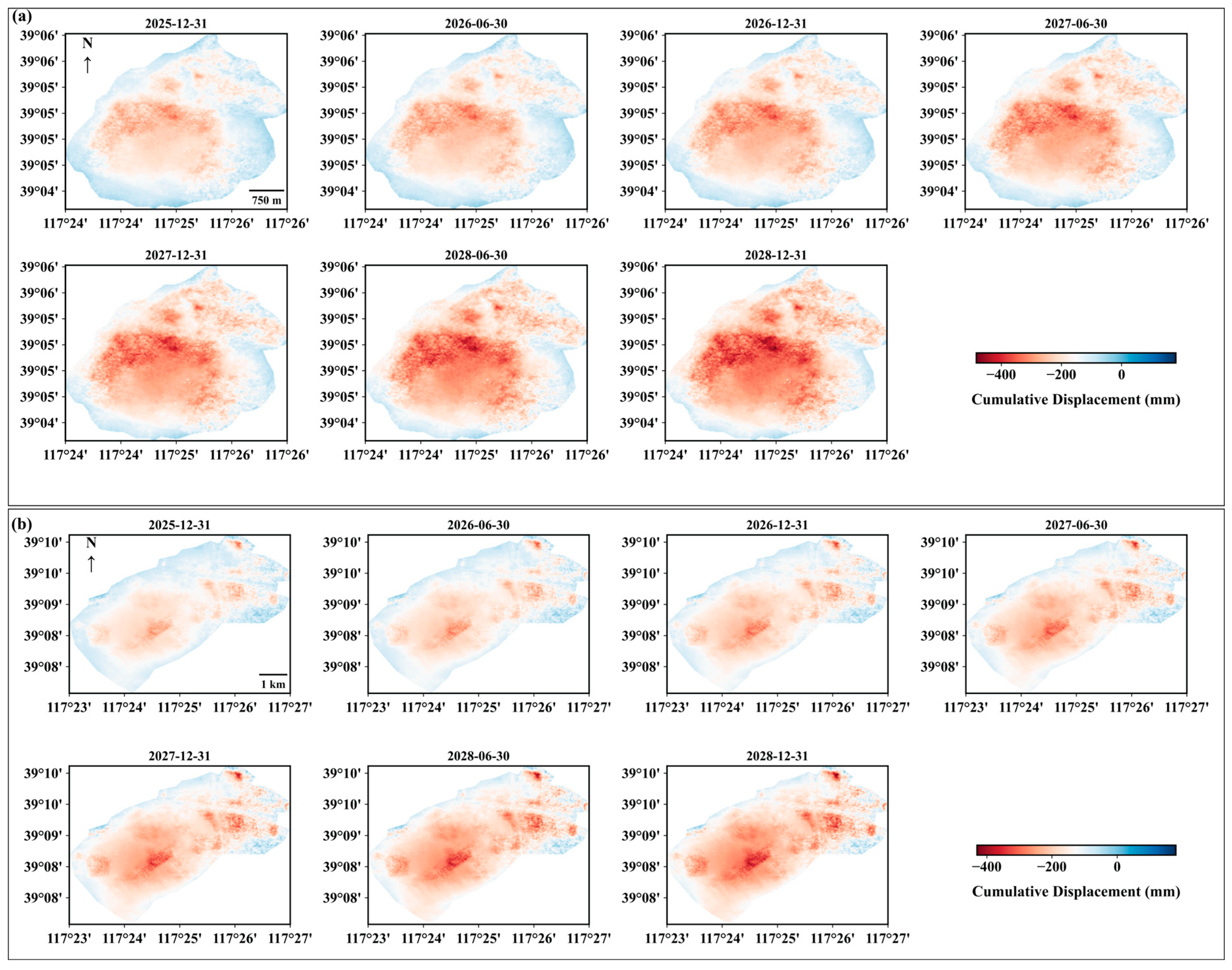
- Projected ground deformation trajectories through 2028 for the Dongli District of Tianjin, providing critical data for urban stability assessment.
Abstract
1. Introduction
2. Materials and Methods
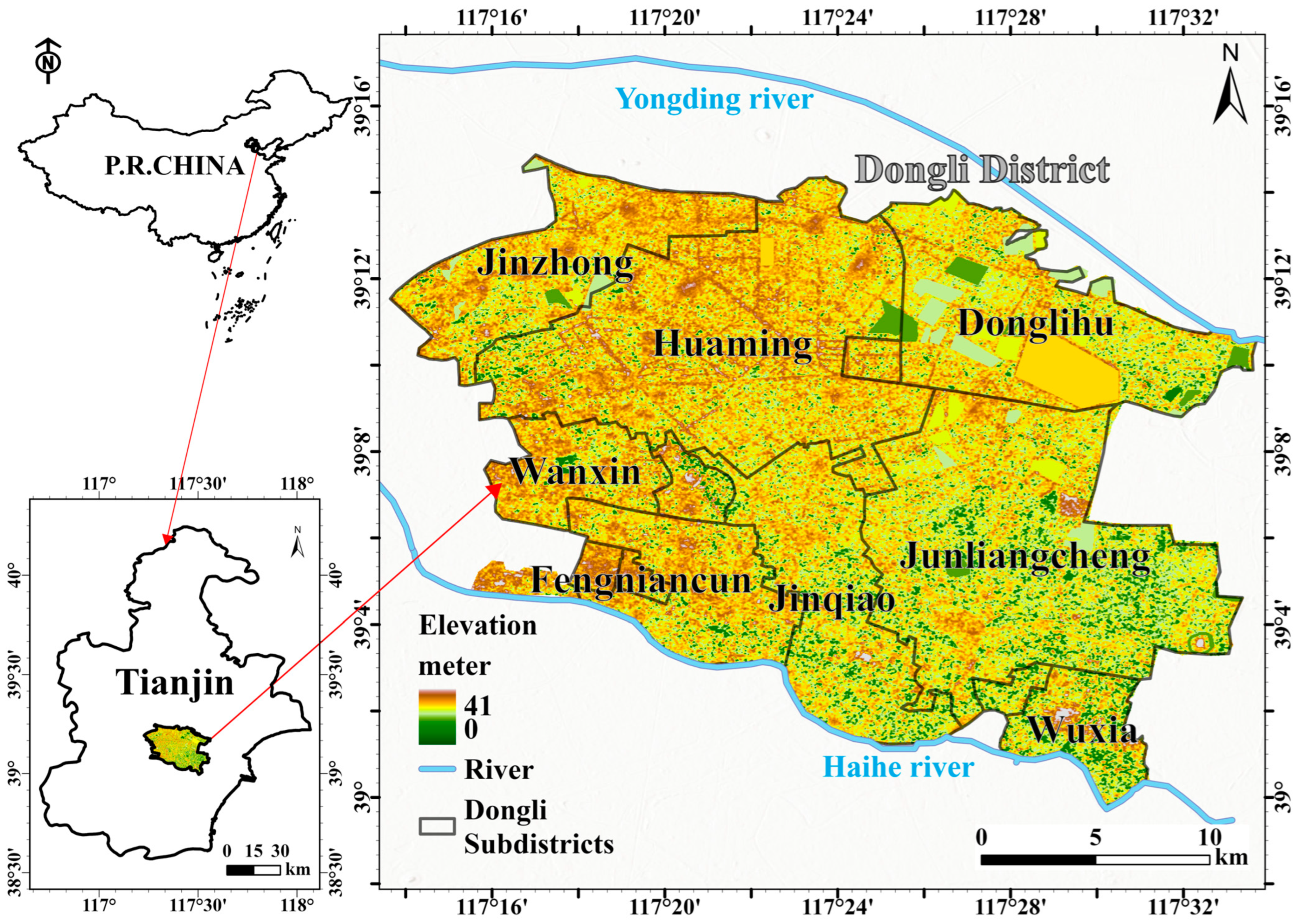
2.1. Research Location
2.2. Geological Structure and Hydrostratigraphy
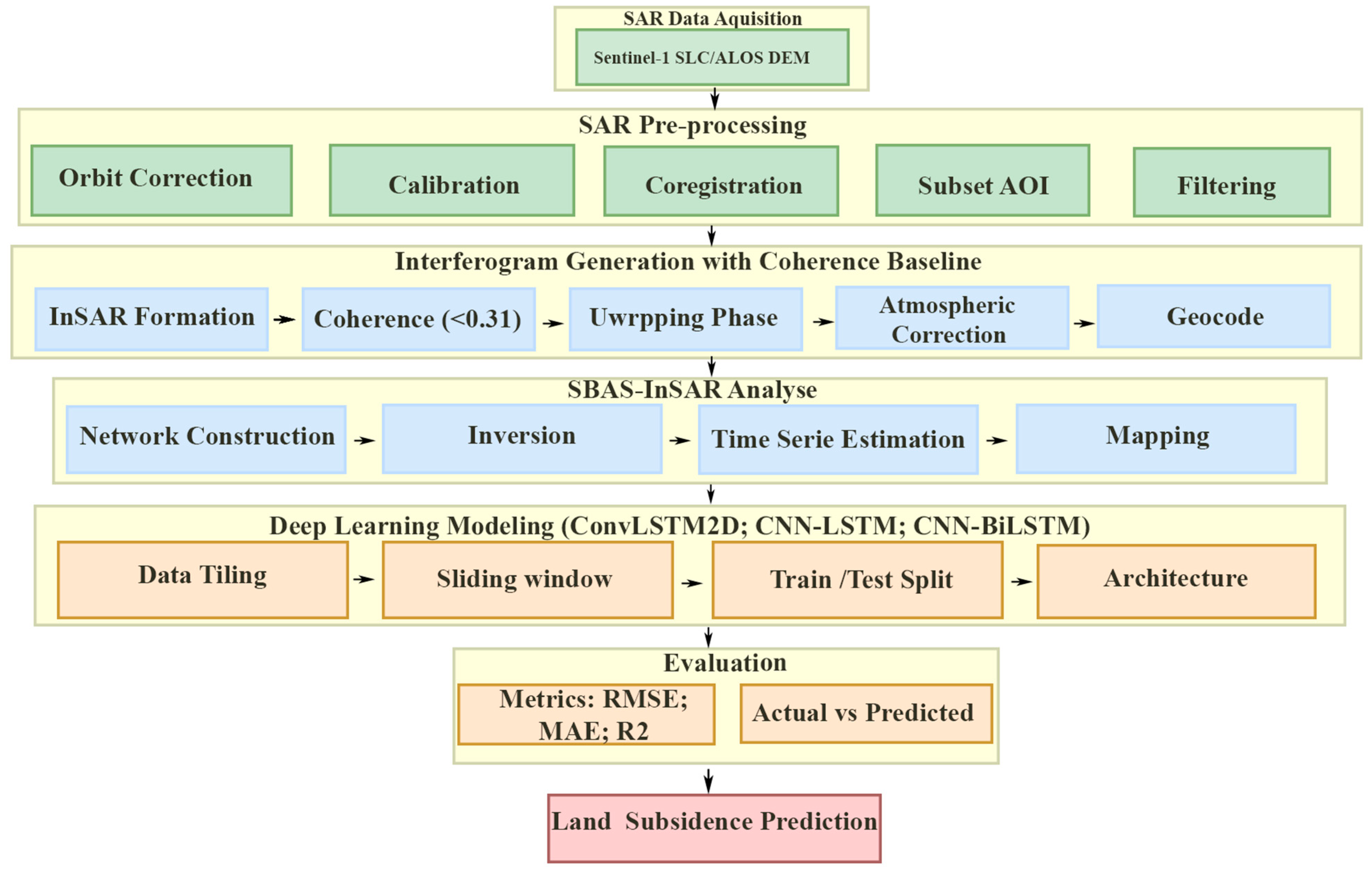
2.3. SAR Data Selection and InSAR Images Processing
2.3.1. Differential Interferometry
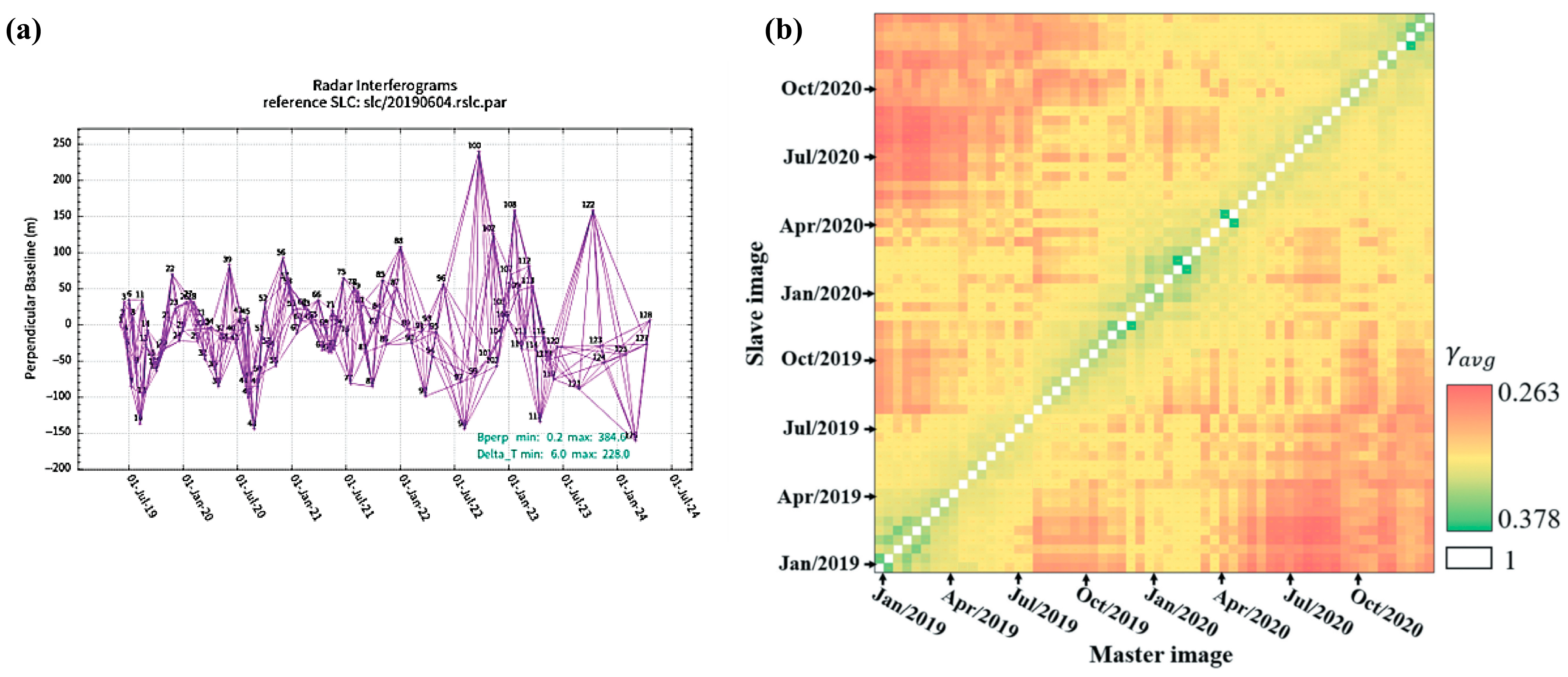
2.3.2. Coherence Baseline-Based Interferometric Pair Selection Method for Surface Deformation Monitoring
2.4. Hybrid Spatiotemporal Architectures for Deformation Forecasting
2.4.1. ConvLSTM2D
2.4.2. Hybrid CNN-LSTM Model
2.4.3. Hybrid CNN-BiLSTM
2.4.4. Hybrid Spatiotemporal Architectures: Data Preprocessing, Sequence Generation, and Partitioning Strategy
2.4.5. Performance Metrics
3. Results
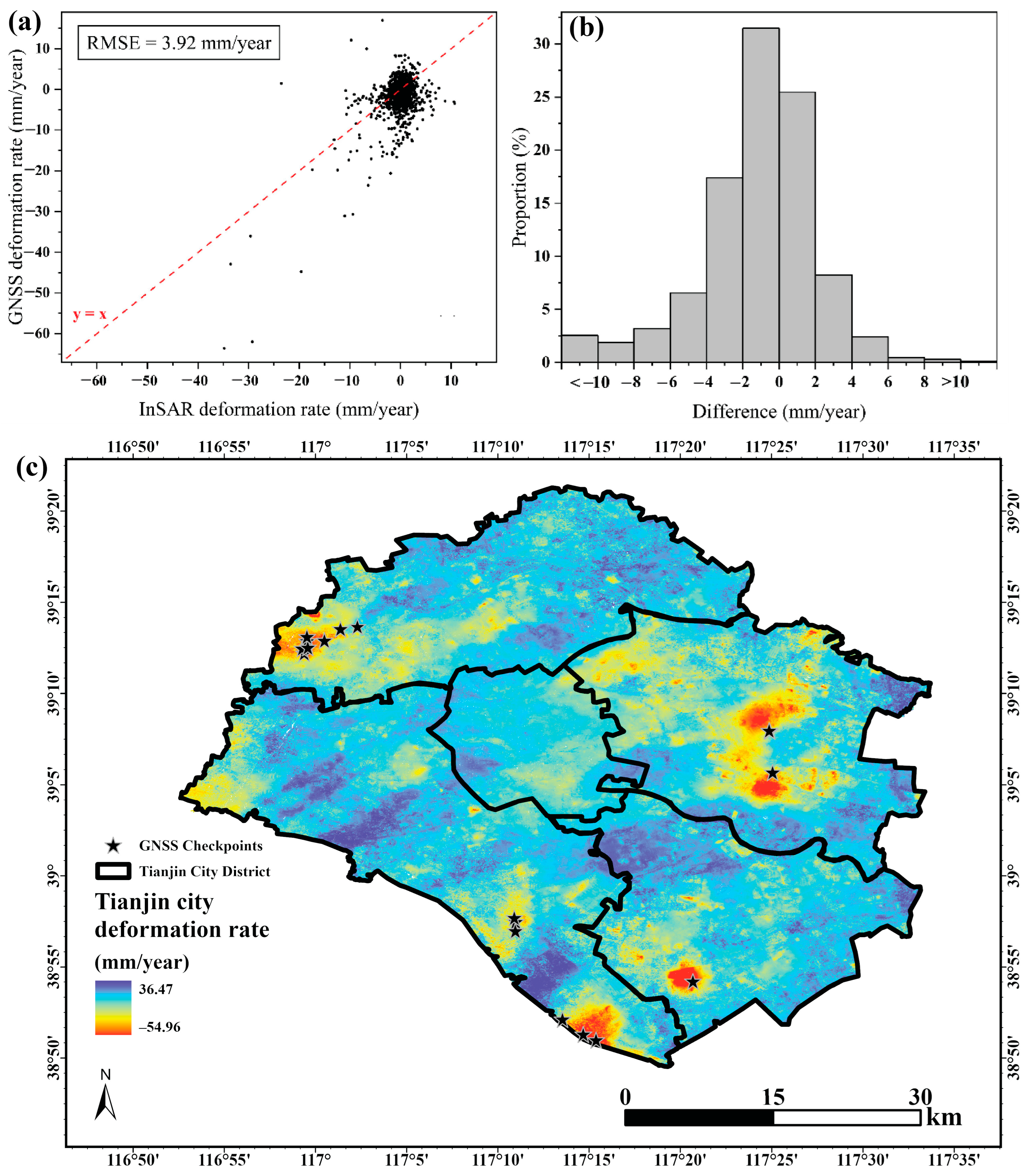
3.1. InSAR Data Processing and Accuracy Evaluation
3.2. Accuracy Evaluation of InSAR Results
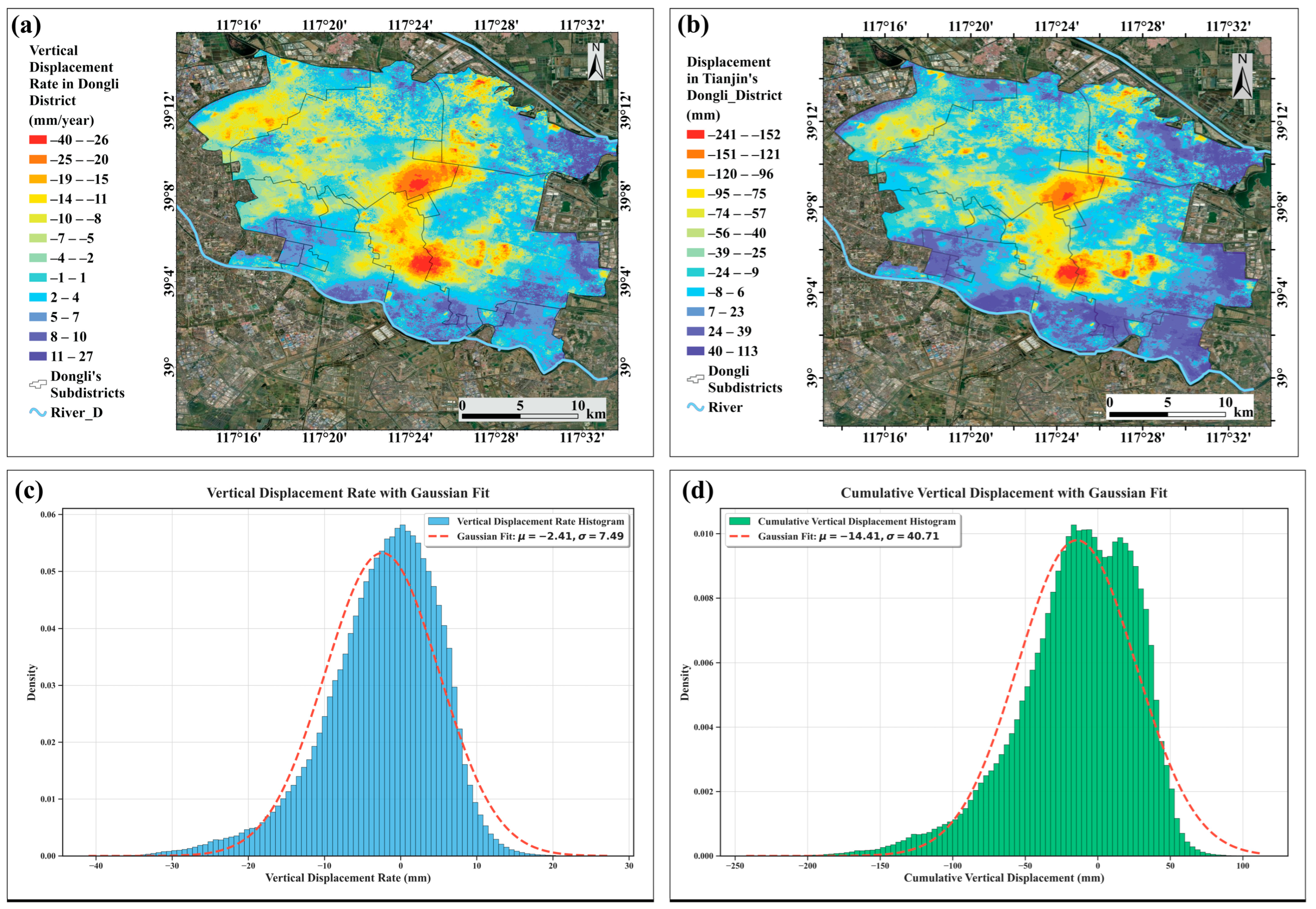
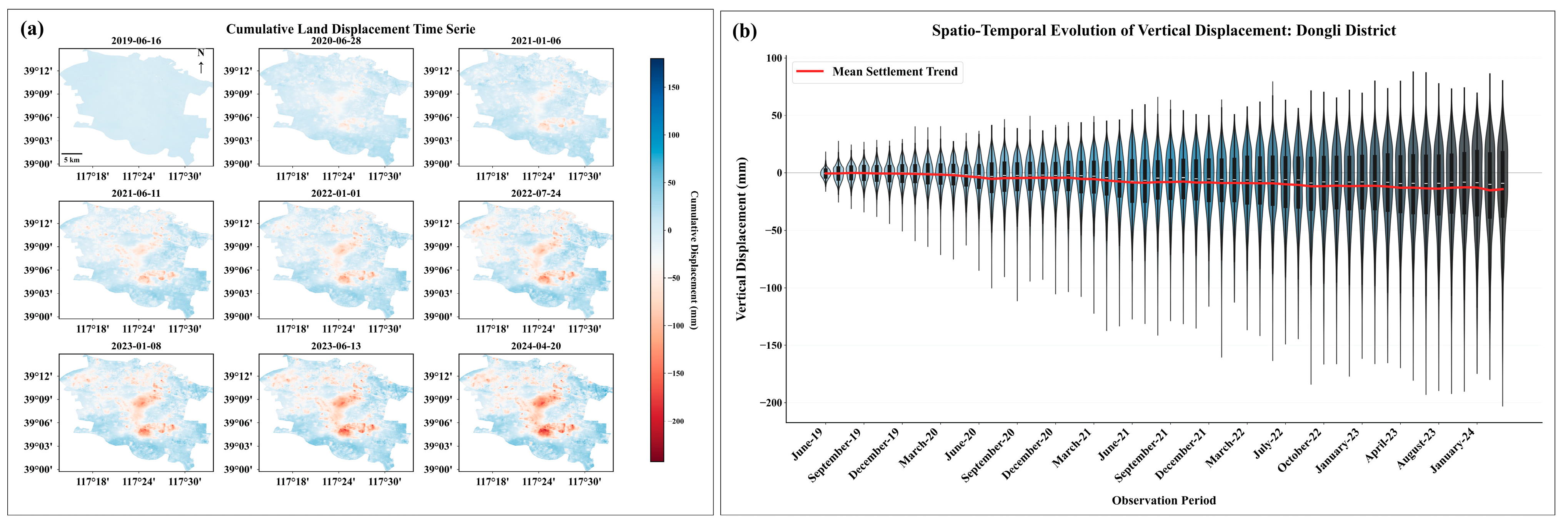
3.3. Land Deformation Time Series in Dongli District from 2019 to 2024
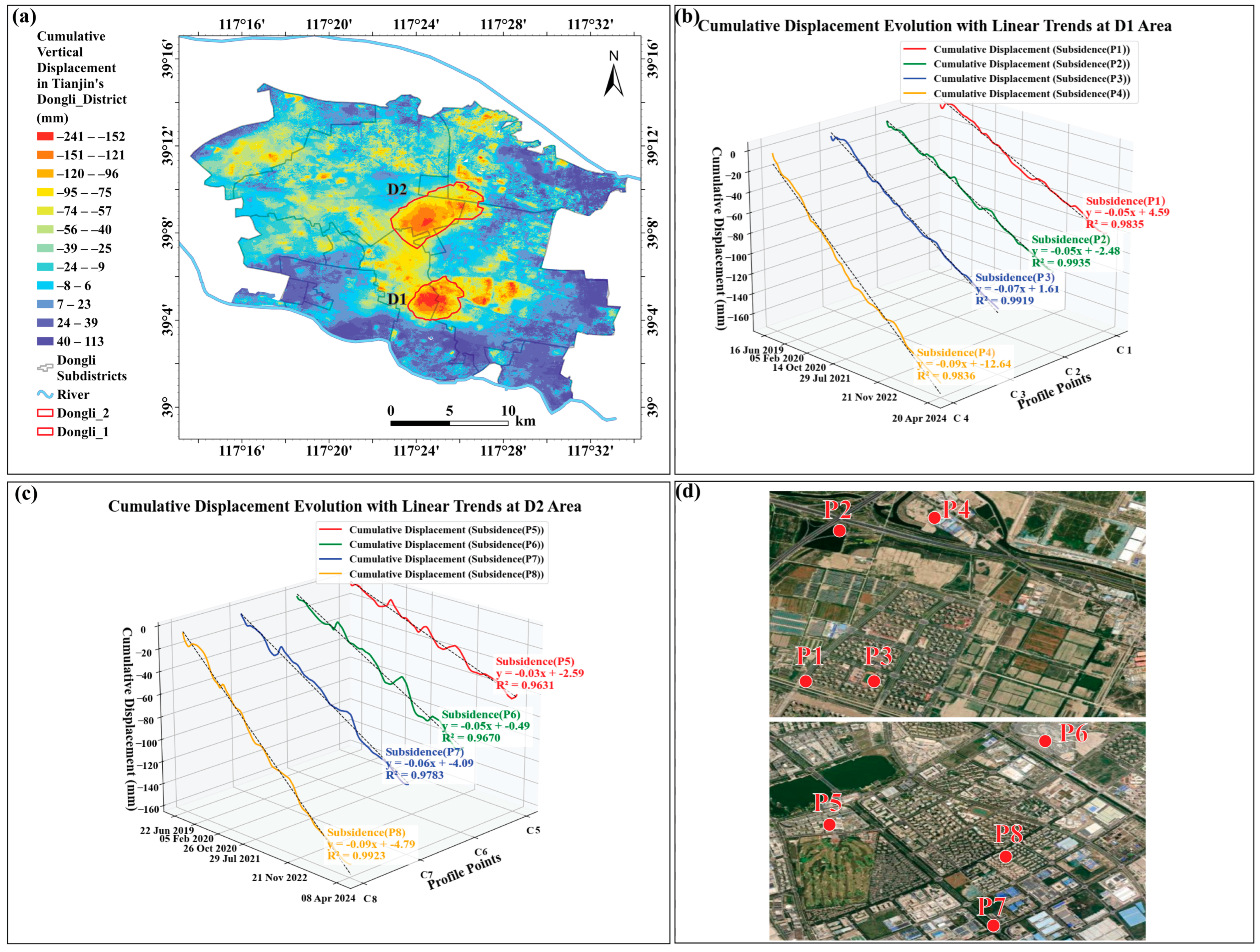
3.4. Spatial Distribution and Temporal Evolution of Land Deformation
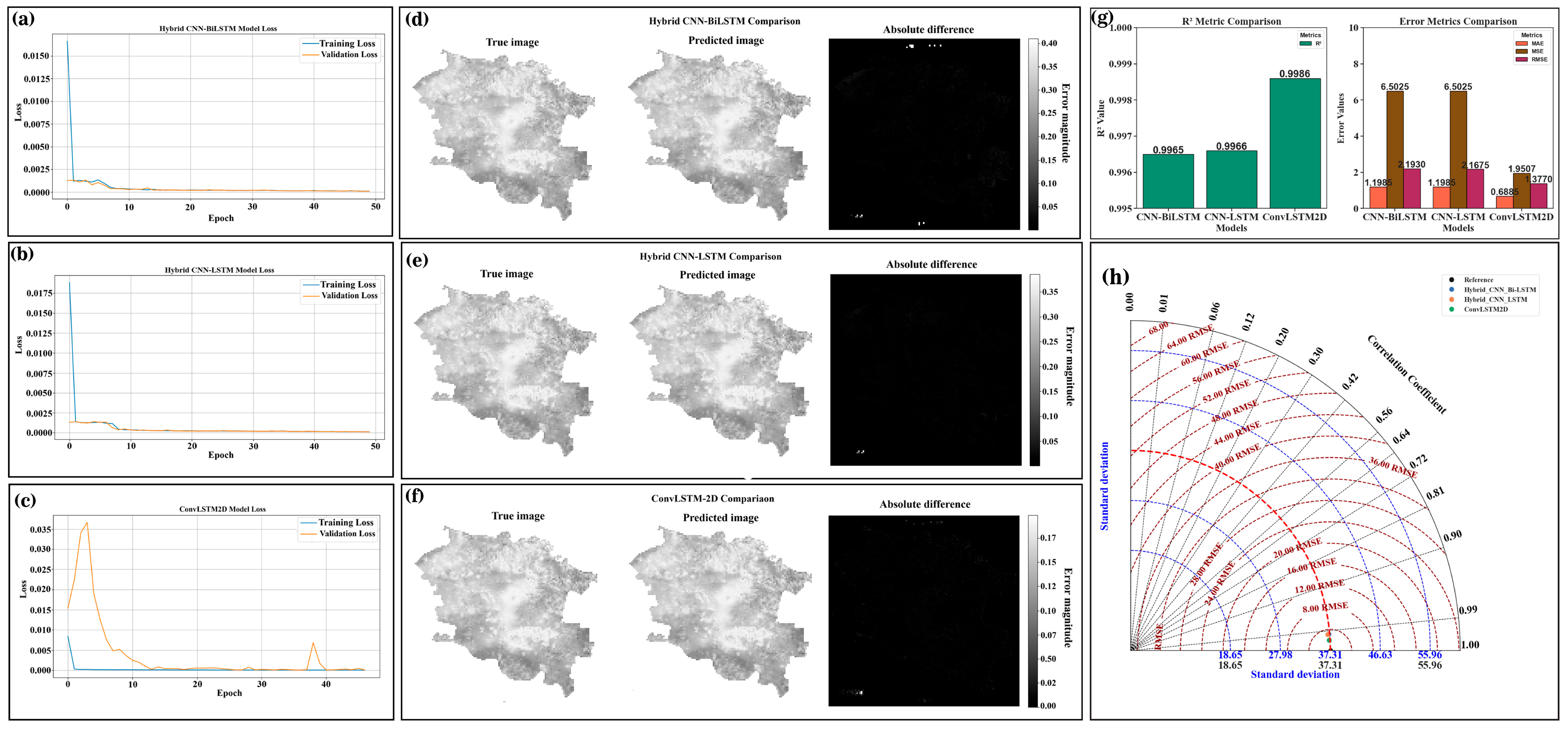
3.5. Spatiotemporal Deep Learning Model Performance Evaluation and Comparative Analysis
3.6. Model Metrics Performance and Model Comparison
3.7. Spatiotemporal Modeling and Prediction of Land Deformation


4. Discussion
5. Conclusions
Author Contributions
Funding
Data Availability Statement
Conflicts of Interest
References
- Zhang, J.; Kou, P.; Tao, Y.; Jin, Z.; Huang, Y.; Cui, J.; Liang, W.; Liu, R. Urban ground subsidence monitoring and prediction using time-series InSAR and machine learning approaches: A case study of Tianjin, China. Environ. Earth Sci. 2024, 83, 473. [Google Scholar] [CrossRef]
- Zhou, H.; Dai, K.; Tang, X.; Xiang, J.; Li, R.; Wu, M.; Peng, Y.; Li, Z. Time-Series InSAR with Deep-Learning-Based Topography-Dependent Atmospheric Delay Correction for Potential Landslide Detection. Remote Sens. 2023, 15, 5287. [Google Scholar] [CrossRef]
- Ma, F.; Zhang, Q.; Sui, L. Prediction of old goaf residual subsidence integrating EDS-InSAR with EsLSTM in the Loess Plateau, China. Front. Earth Sci. 2025, 12, 1511785. [Google Scholar] [CrossRef]
- Zhang, Z.; Hu, C.; Wu, Z.; Zhang, Z.; Yang, S.; Yang, W. Monitoring and analysis of ground subsidence in Shanghai based on PS-InSAR and SBAS-InSAR technologies. Sci. Rep. 2023, 13, 8031. [Google Scholar] [CrossRef] [PubMed]
- Zheng, L.; Wang, Q.; Cao, C.; Shan, B.; Jin, T.; Zhu, K.; Li, Z. Development and Comparison of InSAR-Based Land Subsidence Prediction Models. Remote Sens. 2024, 16, 3345. [Google Scholar] [CrossRef]
- Wen, Y.; Wan, X.; Yuan, D.; Zhang, L.; Ge, D.; Zhang, L. C-LSTM for MT-InSAR Ground Deformation Prediction. In IGARSS 2024—2024 IEEE International Geoscience and Remote Sensing Symposium; IEEE: New York, NY, USA, 2024; pp. 11016–11019. [Google Scholar] [CrossRef]
- Zhang, X.; Cheng, Z.; Xu, B.; Gui, R.; Hu, J.; Yang, C.; Yang, Q.; Xiong, T. Coupling the Relationship between Land Subsidence and Groundwater Level, Ground Fissures in Xi’an City Using Multi-Orbit and Multi-Temporal InSAR. Remote Sens. 2023, 15, 3567. [Google Scholar] [CrossRef]
- Huang, L.; Zhu, P.; Zhang, T.; He, L.; Wu, W.; Ge, Z.; Ai, H. Investigation of land subsidence in Guangdong Province, China, using PS-InSAR technique. Adv. Space Res. 2025, 75, 3507–3520. [Google Scholar] [CrossRef]
- Zhao, D.; Yao, H.; Gu, X. Highway Deformation Monitoring by Multiple InSAR Technology. Sensors 2024, 24, 2988. [Google Scholar] [CrossRef] [PubMed]
- Weng, D.; Chen, W.; Lu, Y.; Ji, S.; Luo, H.; Cai, M. Global DGNSS service for mobile positioning through public corrections. Adv. Space Res. 2023, 72, 4402–4412. [Google Scholar] [CrossRef]
- Tao, Q.; Liu, R.; Li, X.; Gao, T.; Chen, Y.; Xiao, Y.; He, H.; Wei, Y. A method for monitoring three dimensional surface deformation in mining areas combining SBAS-InSAR, GNSS and probability integral method. Sci. Rep. 2025, 15, 2853. [Google Scholar] [CrossRef] [PubMed]
- Chen, S.; Ma, M.; Ma, Y.; Feng, X.; Xu, G.; Li, H.; He, Y. Three-dimensional deformation monitoring of San Francisco Bay based on GNSS-InSAR data. Adv. Space Res. 2025, 75, 451–464. [Google Scholar] [CrossRef]
- Usha, S.; Eatedal, A.; Nuha, A.; Wafa Sulaiman, A. Monitoring land subsidence using Sentinel-1A, persistent scatterer InSAR, and machine learning techniques. J. S. Am. Earth Sci. 2025, 155, 105433. [Google Scholar] [CrossRef]
- Xiao, Y.; Tao, Q.; Hu, L.; Liu, R.; Li, X. A deep learning-based combination method of spatio-temporal prediction for regional mining surface subsidence. Sci. Rep. 2024, 14, 19139. [Google Scholar] [CrossRef] [PubMed]
- Liu, P.; Li, Q.; Li, Z.; Hoey, T.; Liu, G.; Wang, C.; Hu, Z.; Zhou, Z.; Singleton, A. Anatomy of Subsidence in Tianjin from Time Series InSAR. Remote Sens. 2016, 8, 266. [Google Scholar] [CrossRef]
- Zhang, Y.; Wu, H.A.; Kang, Y.; Zhu, C. Ground Subsidence in the Beijing-Tianjin-Hebei Region from 1992 to 2014 Revealed by Multiple SAR Stacks. Remote Sens. 2016, 8, 675. [Google Scholar] [CrossRef]
- Yi, L.; Fang, Z.; He, X.; Chen, S.; Wei, W.; Qiang, Y. Land subsidence in Tianjin, China. Environ. Earth Sci. 2011, 62, 1151–1161. [Google Scholar] [CrossRef]
- Wang, K.; Wang, G.; Bao, Y.; Su, G.; Wang, Y.; Shen, Q.; Zhang, Y.; Wang, H. Preventing subsidence reoccurrence in Tianjin: New preconsolidation head and safe pumping buffer. Groundwater 2024, 62, 778–794. [Google Scholar] [CrossRef]
- Shang, J.; Wang, M.; Wang, X.; Yang, M.; Wu, Y.; Du, W. Three-dimensional surface deformation field monitoring and influencing factors analysis in mountainous areas based on SBAS-INSAR technology (Tianjin, China). Sci. Rep. 2025, 15, 25702. [Google Scholar] [CrossRef] [PubMed]
- Luo, Q.; Perissin, D.; Zhang, Y.; Jia, Y. L- and X-Band Multi-Temporal InSAR Analysis of Tianjin Subsidence. Remote Sens. 2014, 6, 7933–7951. [Google Scholar] [CrossRef]
- Liu, H.-H.; Zhang, Y.-Q.; Wang, R.; Gong, H.-L.; Gu, Z.-Q.; Kan, J.-L.; Luo, Y.; Jia, S.-M. Monitoring and analysis of land subsidence along the Beijing-Tianjin high-speed railway (Beijing section). Chin. J. Geophys. 2016, 59, 2424–2432. [Google Scholar] [CrossRef]
- Qiu, P.; Liu, F.; Zhang, J. Land Subsidence Prediction Model Based on the Long Short-Term Memory Neural Network Optimized Using the Sparrow Search Algorithm. Appl. Sci. 2023, 13, 11156. [Google Scholar] [CrossRef]
- Zhang, X.; Chen, Q.; Yang, M.; Zhao, Z.; Zheng, Y.; Dai, Q.; He, Y.; Cai, D.; Xu, T. Surface Deformation Monitoring and Prediction of Longtantian Open-Pit Mine Based on SBAS-InSAR and CNN-BiLSTM Techniques. IEEE J. Sel. Top. Appl. Earth Obs. Remote Sens. 2025, 18, 17706–17727. [Google Scholar] [CrossRef]
- Soni, R.; Alam, M.S.; Vishwakarma, G.K. Prediction of InSAR deformation time-series using improved LSTM deep learning model. Sci. Rep. 2025, 15, 5333. [Google Scholar] [CrossRef] [PubMed]
- Chen, T.; Ning, D.; Liu, Y. Land Subsidence Predictions Based on a Multi-Component Temporal Convolutional Gated Recurrent Unit Model in Kunming City. Appl. Sci. 2024, 14, 10021. [Google Scholar] [CrossRef]
- Azarm, Z.; Mehrabi, H.; Nadi, S. Enhanced Land Subsidence Interpolation through a Hybrid Deep Convolutional Neural Network and InSAR Time Series. Geosci. Model Dev. Discuss. 2024, 2024, 6903–6919. [Google Scholar] [CrossRef]
- Zhu, M.; Yu, X.; Tan, H.; Yuan, J.; Chen, K.; Xie, S.; Han, Y.; Long, W. High-precision monitoring and prediction of mining area surface subsidence using SBAS-InSAR and CNN-BiGRU-attention model. Sci. Rep. 2024, 14, 28968. [Google Scholar] [CrossRef] [PubMed]
- Kariminejad, N.; Mohammadifar, A.; Sepehr, A.; Garajeh, M.K.; Rezaei, M.; Desir, G.; Quesada-Román, A.; Gholami, H. Detection of land subsidence using hybrid and ensemble deep learning models. Appl. Geomat. 2024, 16, 593–610. [Google Scholar] [CrossRef]
- Feng, H.-Z.; Yu, H.-Y.; Wang, W.-Y.; Wang, W.-X.; Du, M.-Q. Recognition of mortar pumpability via computer vision and deep learning. J. Electron. Sci. Technol. 2023, 21, 100215. [Google Scholar] [CrossRef]
- Naz, F.; She, L.; Sinan, M.; Shao, J. Enhancing Radar Echo Extrapolation by ConvLSTM2D for Precipitation Nowcasting. Sensors 2024, 24, 459. [Google Scholar] [CrossRef] [PubMed]
- Xu, H.; Chen, F.; Zhou, W. A comparative case study of MTInSAR approaches for deformation monitoring of the cultural landscape of the Shanhaiguan section of the Great Wall. Herit. Sci. 2021, 9, 71. [Google Scholar] [CrossRef]
- Li, S.; Xu, W.; Li, Z. Review of the SBAS InSAR Time-series algorithms, applications, and challenges. Geod. Geodyn. 2022, 13, 114–126. [Google Scholar] [CrossRef]
- Wang, S.; Zhang, G.; Chen, Z.; Cui, H.; Zheng, Y.; Xu, Z.; Li, Q. Surface deformation extraction from small baseline subset synthetic aperture radar interferometry (SBAS-InSAR) using coherence-optimized baseline combinations. GISci. Remote Sens. 2022, 59, 295–309. [Google Scholar] [CrossRef]
- Su, G.; Xiong, C.; Zhang, G.; Wang, Y.; Shen, Q.; Chen, X.; An, H.; Qin, L. Coupled processes of groundwater dynamics and land subsidence in the context of active human intervention, a case in Tianjin, China. Sci. Total Environ. 2023, 903, 166803. [Google Scholar] [CrossRef] [PubMed]
- Huang, C.; Liu, K.; Ma, T.; Xue, H.; Wang, P.; Li, L. Analysis of the impact mechanisms and driving factors of urban spatial morphology on urban heat islands. Sci. Rep. 2025, 15, 18589. [Google Scholar] [CrossRef] [PubMed]
- He, Y.; Chen, T.; Zheng, Z.; Mi, F. Does urban green space justly improve public health and well-being? A case study of Tianjin, a megacity in China. J. Clean. Prod. 2022, 380, 134920. [Google Scholar] [CrossRef]
- Wang, G.; Duan, Z.; Yu, T.; Shen, Z.; Zhang, Y. Analysis of coastline changes under the impact of human activities during 1985–2020 in Tianjin, China. PLoS ONE 2023, 18, e0289969. [Google Scholar] [CrossRef] [PubMed]
- Liu, S.; Bai, M. Land subsidence along the Beijing-Tianjin high-speed railway before and after the South-to-North water diversion project with multi-source monitoring datasets. Front. Earth Sci. 2024, 12, 1372105. [Google Scholar] [CrossRef]
- Yu, H.; Gong, H.; Chen, B. Analysis of the Superposition Effect of Land Subsidence and Sea-Level Rise in the Tianjin Coastal Area and Its Emerging Risks. Remote Sens. 2023, 15, 3341. [Google Scholar] [CrossRef]
- Jiang, Z.; Zhu, J.; Guo, H.; Qiu, K.; Tang, M.; Yang, X.; Liu, J. South-to-North Water Diversion Halting Long-Lived Subsidence in Tianjin, North China Plain. Remote Sens. 2024, 16, 3213. [Google Scholar] [CrossRef]
- Qu, H.; Guo, Z. Study of Land Subsidence in Tianjin. In Geosciences and Human Survival, Environment, Natural Hazards, Global Change; CRC Press: Boca Raton, FL, USA, 2023; pp. 215–223. [Google Scholar]
- Alzubaidi, L.; Zhang, J.; Humaidi, A.J.; Al-Dujaili, A.; Duan, Y.; Al-Shamma, O.; Santamaría, J.; Fadhel, M.A.; Al-Amidie, M.; Farhan, L. Review of deep learning: Concepts, CNN architectures, challenges, applications, future directions. J. Big Data 2021, 8, 53. [Google Scholar] [CrossRef] [PubMed]



| Aquifer Group | Approximate Depth Focus | Primary Role and Behavior |
|---|---|---|
| Aquifer I (shallow) | near surface to tens of meters | Responds rapidly to precipitation and tidal/seawater influence and has limited long-term pumping [34]. |
| Aquifer II (middle) | tens to 100–200 m | It is commonly exploited for local use and contributes to intermediate responses [34]. |
| Aquifer III (deep confined) | 100–300 m (monitoring and compressive layers around 94–182 m in some sites) | It is a major historical exploitation layer and the principal source of inelastic compaction in many areas [34,39]. |
| Aquifer IV (deepest confined) | 200–450 m | Deep storage is subject to long-term drawdown and inelastic compaction in high-extraction zones [18]. |
| Parameters | ConvLSTM2D | Hybrid CNN-LSTM | Hybrid CNN-BiLSTM |
|---|---|---|---|
| MAE | 0.68 | 1.19 | 1.19 |
| MSE | 1.95 | 6.50 | 6.50 |
| R2 | 0.99 | 0.99 | 0.99 |
| RMSE | 1.37 | 2.16 | 2.19 |
| Standard deviation of error | 1.35 | 2.16 | 2.16 |
| Training time | 5.86 h | 0.51 h | 0.95 h |
Disclaimer/Publisher’s Note: The statements, opinions and data contained in all publications are solely those of the individual author(s) and contributor(s) and not of MDPI and/or the editor(s). MDPI and/or the editor(s) disclaim responsibility for any injury to people or property resulting from any ideas, methods, instructions or products referred to in the content. |
© 2026 by the authors. Licensee MDPI, Basel, Switzerland. This article is an open access article distributed under the terms and conditions of the Creative Commons Attribution (CC BY) license.
Share and Cite
Miao, J.; Talong, R.K.; Wang, M.; Zhang, Y.; Du, D.; Liu, H.; Gao, Y.; Bai, Y.; Liu, W. Monitoring and Prediction of Ground Deformation Using InSAR and Machine Learning Approaches in Tianjin City, China. Remote Sens. 2026, 18, 2294. https://doi.org/10.3390/rs18142294
Miao J, Talong RK, Wang M, Zhang Y, Du D, Liu H, Gao Y, Bai Y, Liu W. Monitoring and Prediction of Ground Deformation Using InSAR and Machine Learning Approaches in Tianjin City, China. Remote Sensing. 2026; 18(14):2294. https://doi.org/10.3390/rs18142294
Chicago/Turabian StyleMiao, Jinjie, Rally Kimpese Talong, Minsen Wang, Ying Zhang, Dong Du, Hongwei Liu, Yihang Gao, Yaonan Bai, and Wei Liu. 2026. "Monitoring and Prediction of Ground Deformation Using InSAR and Machine Learning Approaches in Tianjin City, China" Remote Sensing 18, no. 14: 2294. https://doi.org/10.3390/rs18142294
APA StyleMiao, J., Talong, R. K., Wang, M., Zhang, Y., Du, D., Liu, H., Gao, Y., Bai, Y., & Liu, W. (2026). Monitoring and Prediction of Ground Deformation Using InSAR and Machine Learning Approaches in Tianjin City, China. Remote Sensing, 18(14), 2294. https://doi.org/10.3390/rs18142294