Landslide Mapping and Susceptibility Assessment in the Middle and Lower Reaches of the Nujiang River (2017–2025) Using Satellite Embedding and Multidimensional Environmental Factors


Highlights
- A satellite embedding-driven framework was developed for annual landslide inventory mapping in the middle and lower reaches of the Nujiang River from 2017 to 2025.
- Landslides showed strong spatial clustering, marked interannual variability, and persistent hotspot regions, revealing distinct spatiotemporal patterns of landslide activity.
- The proposed workflow improves the efficiency of annual landslide identification and spatiotemporal characterization in complex mountainous terrain.
- The findings provide scientific support for regional landslide monitoring, hotspot tracking, hazard zonation, and risk-informed management.
Abstract
1. Introduction
2. Materials and Methods
2.1. Study Area
2.2. Data and Preprocessing
2.2.1. Satellite Embedding Dataset
2.2.2. Topographic-Geological Factors
2.2.3. Climatic-Hydrological Factors
2.2.4. Land-Cover Factors
2.2.5. Human-Activity Factors
2.2.6. Field Surveys and HR Imagery
2.3. Methodology
2.3.1. Embedding-Change Analysis for Visual Interpretation Guidance
2.3.2. Construction of Training Samples from Satellite Imagery and Field Surveys
2.3.3. Mapping Landslides Using GEE and RF Algorithm
2.3.4. Landslide Susceptibility Modeling Using Multidimensional Factors
2.3.5. Performance Evaluation Metrics
3. Results
3.1. Accuracy Assessment
3.1.1. Accuracy of Landslide Mapping
3.1.2. Performance of the Landslide Susceptibility Model
3.2. Landslide Mapping Results for 2017 to 2025
3.3. Landslide Susceptibility Results
4. Discussion
4.1. Major Controlling Predictors of Landslide Occurrence
4.2. Spatial Distribution Characteristics of Landslides
4.3. Temporal Dynamics of Mapped Landslide-Affected Slope Units
4.4. Limitations and Future Improvements
5. Conclusions
- (1)
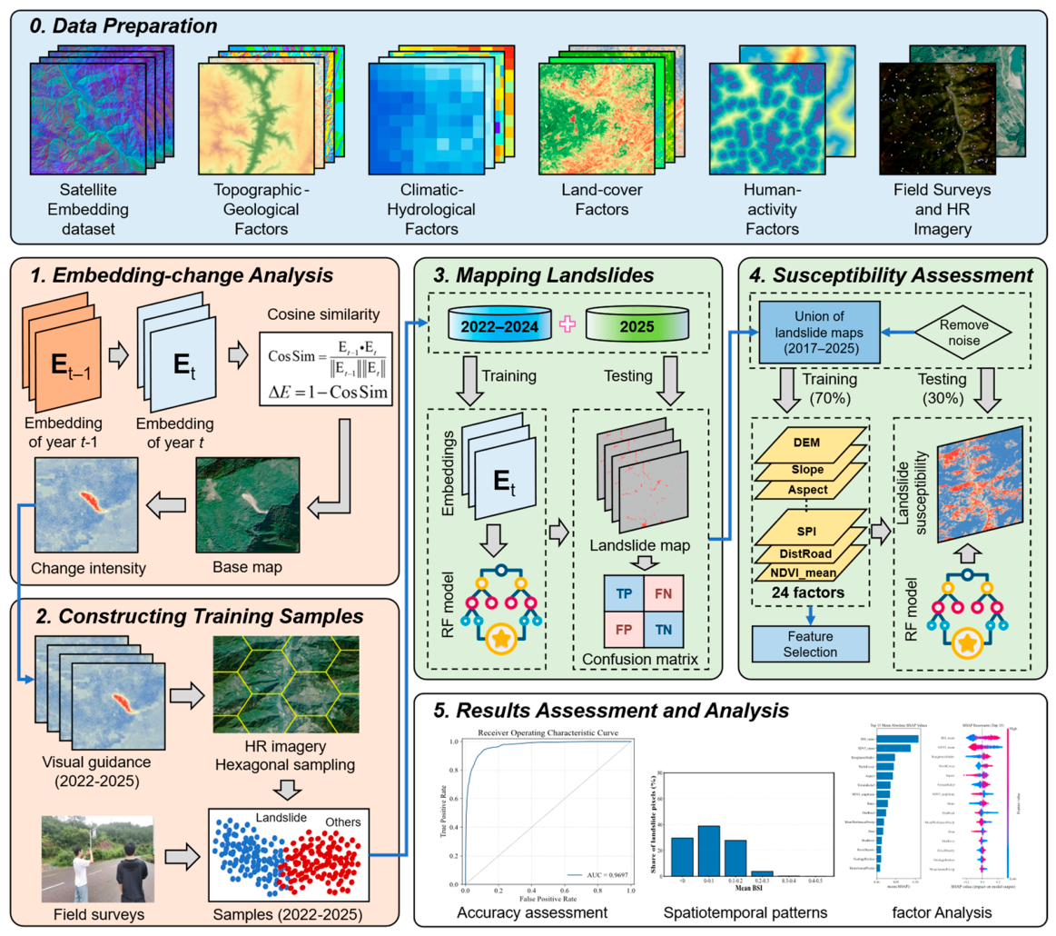
- This study developed a satellite embedding-assisted workflow for annual landslide mapping and susceptibility assessment in the middle and lower reaches of the Nujiang River. Annual 10 m maps of remote-sensing-identifiable landslide surfaces for 2017–2025 and an inventory-derived susceptibility map were generated by integrating satellite embedding data, HR imagery, field evidence, GEE, and RF modeling. The results demonstrate the potential of satellite embeddings for regional landslide mapping in complex mountainous terrain.
- (2)
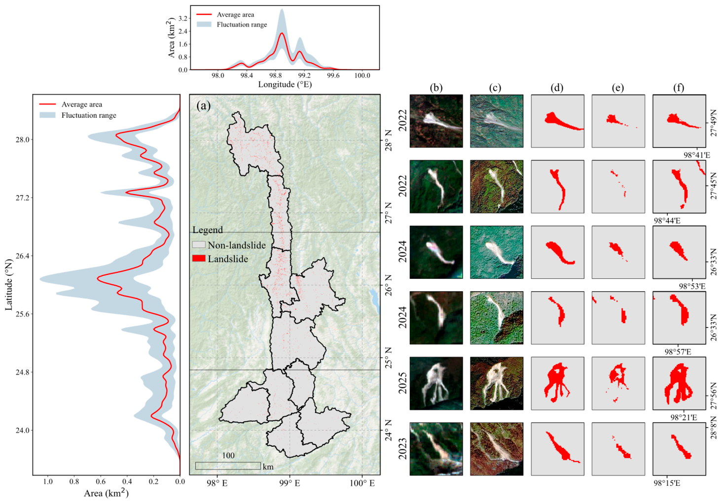
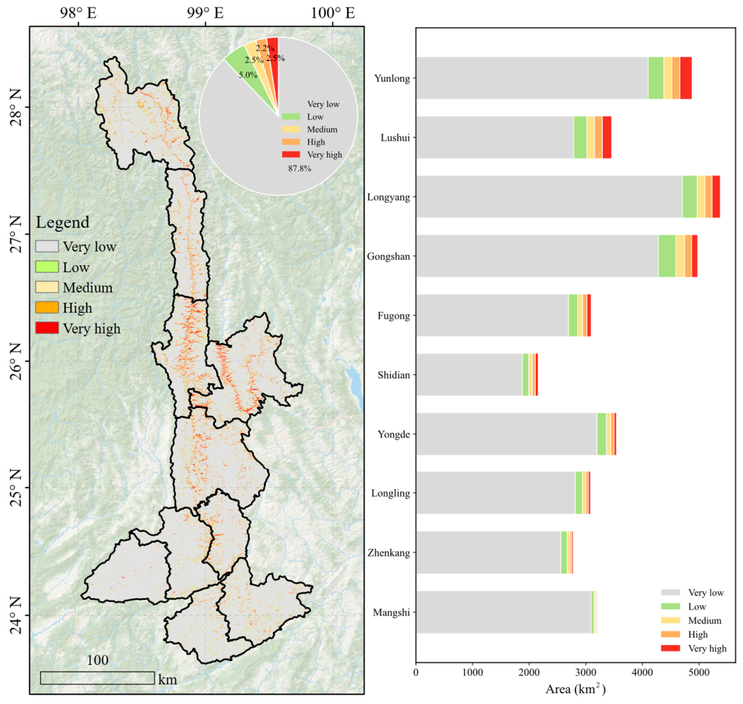
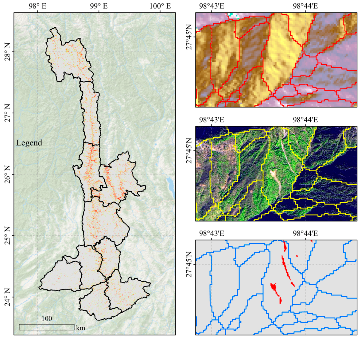
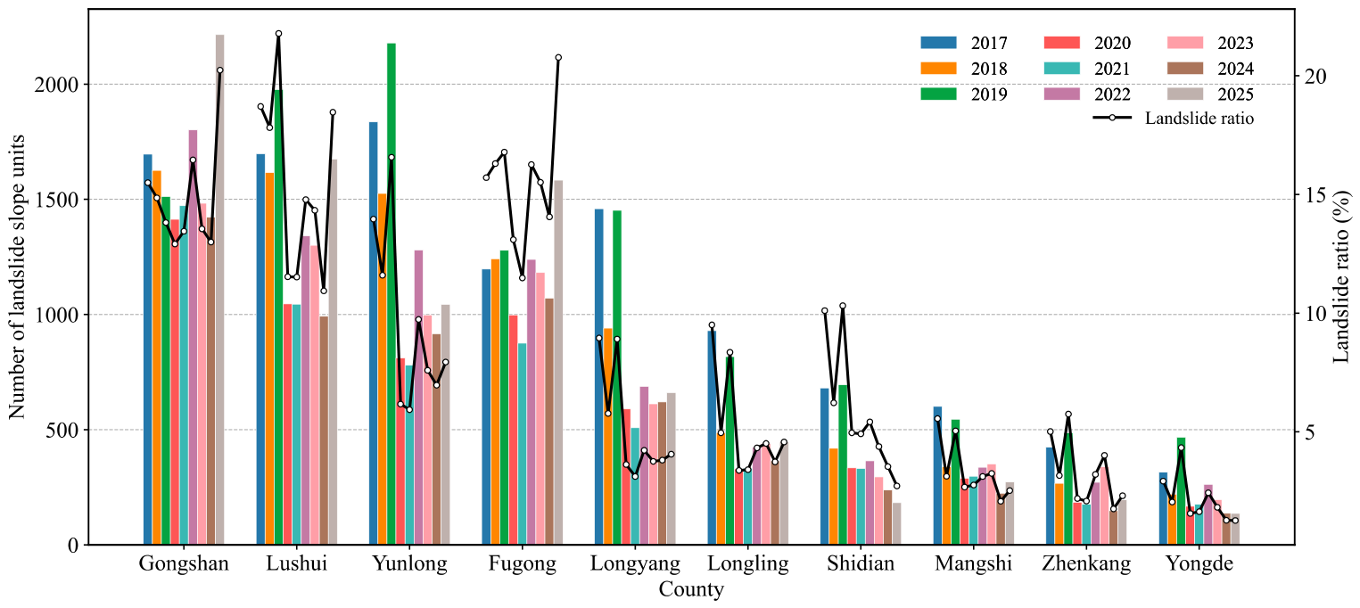
- The mapped landslide surfaces showed clear spatial clustering along the Nujiang River corridor and adjacent high-relief canyon slopes, especially in Gongshan, Fugong, Lushui, and Yunlong. At the slope-unit scale, mapped landslide-affected units exhibited pronounced interannual variability, while the main hotspot regions remained broadly stable.
- (3)
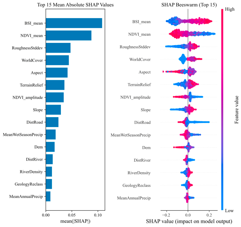
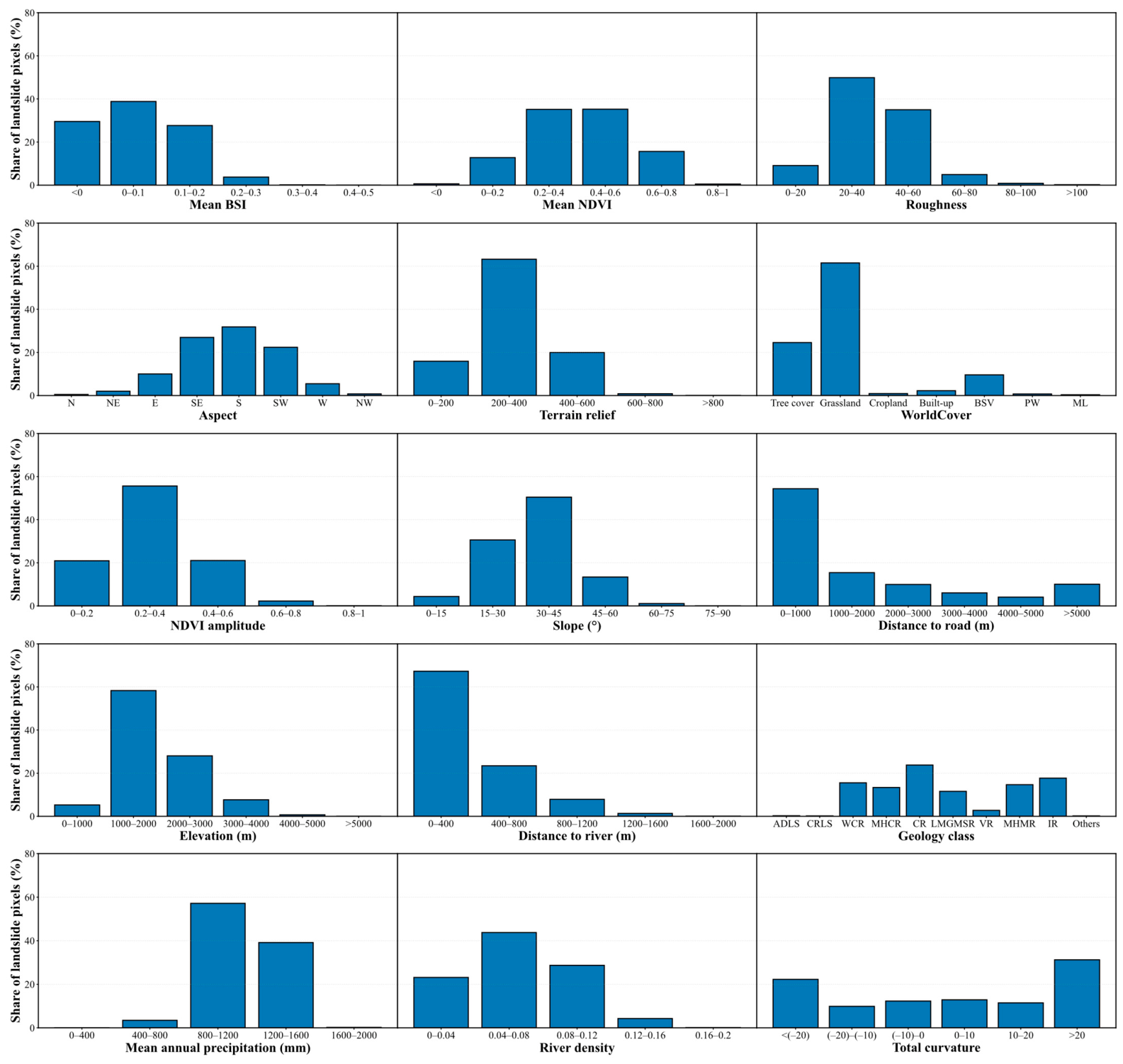
- The susceptibility analysis identified BSI_mean, NDVI_mean, RoughnessStddev, Aspect, and TerrainRelief as the dominant predictors for the combined mapped landslide class. These results indicate that bare-surface exposure, vegetation condition, terrain roughness, slope orientation, and relief are strongly associated with mapped landslide occurrence. However, as BSI_mean and NDVI_mean may partly reflect post-failure spectral responses, their SHAP contributions indicate predictive associations rather than purely causal controls.
- (4)
- The results are framed within the scope of remote-sensing-based annual landslide mapping. The annual maps characterize detectable landslide surfaces rather than strict new-event inventories, while the susceptibility map represents an inventory-derived background susceptibility result. Applications of the results therefore need to account for uncertainties related to post-failure spectral responses, static environmental predictors, and mapped-inventory-based labels. Further integration of deformation monitoring, updated terrain and land-cover data, and uncertainty-aware modeling would improve dynamic landslide monitoring and susceptibility assessment.
Author Contributions
Funding
Data Availability Statement
Acknowledgments
Conflicts of Interest
Abbreviations
| ADLS | Alluvial-Diluvial Loose Sediments |
| AUC | Area under curve |
| BSI | Bare Soil Index |
| BSV | Bare/sparse vegetation |
| CR | Carbonate Rocks |
| CRLS | Colluvial-Residual Loose Sediments |
| DEM | Digital Elevation Model |
| Gaofen | GF |
| GEE | Google Earth Engine |
| HAND | Height above nearest drainage |
| HR | High-resolution |
| InSAR | Interferometric Synthetic Aperture Radar |
| IR | Intrusive Rocks |
| LMGMSR | Low-to-Medium Grade Metamorphic Soft Rocks |
| MHCR | Moderately Hard Clastic Rocks |
| MHMR | Moderately Hard Metamorphic Rocks |
| ML | Moss/lichen |
| NDVI | Normalized difference vegetation index |
| OA | Overall accuracy |
| PA | Producer’s accuracy |
| PW | Permanent water |
| RF | Random Forest |
| RFECV | Recursive feature elimination with cross-validation |
| ROC | Receiver operating characteristic |
| SAR | Synthetic Aperture Radar |
| SHAP | Shapley Additive Explanations |
| SPI | Stream Power Index |
| SRTM | Shuttle Radar Topography Mission |
| TWI | Topographic Wetness Index |
| UA | User’s accuracy |
| UPA | Upslope-contributing area |
| UPG | Upstream gradient-related |
| VR | Volcanic Rocks |
| WCR | Weak Clastic Rocks |
| Ziyuan | ZY |
References
- Li, B.V.; Jenkins, C.N.; Xu, W. Strategic protection of landslide vulnerable mountains for biodiversity conservation under land-cover and climate change impacts. Proc. Natl. Acad. Sci. USA 2022, 119, e2113416118. [Google Scholar] [CrossRef]
- Li, D.; Lu, X.; Walling, D.E.; Zhang, T.; Steiner, J.F.; Wasson, R.J.; Harrison, S.; Nepal, S.; Nie, Y.; Immerzeel, W.W.; et al. High Mountain Asia hydropower systems threatened by climate-driven landscape instability. Nat. Geosci. 2022, 15, 520–530. [Google Scholar] [CrossRef]
- Alcántara-Ayala, I. Landslides in a changing world. Landslides 2025, 22, 2851–2865. [Google Scholar] [CrossRef]
- Xu, Q.; Zhao, B.; Dai, K.; Dong, X.; Li, W.; Zhu, X.; Yang, Y.; Xiao, X.; Wang, X.; Huang, J.; et al. Remote sensing for landslide investigations: A progress report from China. Eng. Geol. 2023, 321, 107156. [Google Scholar] [CrossRef]
- Froude, M.J.; Petley, D.N. Global fatal landslide occurrence from 2004 to 2016. Nat. Hazards Earth Syst. Sci. 2018, 18, 2161–2181. [Google Scholar] [CrossRef]
- Crozier, M.J. Deciphering the effect of climate change on landslide activity: A review. Geomorphology 2010, 124, 260–267. [Google Scholar] [CrossRef]
- Patton, A.I.; Rathburn, S.L.; Capps, D.M. Landslide response to climate change in permafrost regions. Geomorphology 2019, 340, 116–128. [Google Scholar] [CrossRef]
- Novellino, A.; Pennington, C.; Leeming, K.; Taylor, S.; Alvarez, I.G.; McAllister, E.; Arnhardt, C.; Winson, A. Mapping landslides from space: A review. Landslides 2024, 21, 1041–1052. [Google Scholar] [CrossRef]
- Sun, L.; Muller, J.-P. Evaluation of the Use of Sub-Pixel Offset Tracking Techniques to Monitor Landslides in Densely Vegetated Steeply Sloped Areas. Remote Sens. 2016, 8, 659. [Google Scholar] [CrossRef]
- Casagli, N.; Intrieri, E.; Tofani, V.; Gigli, G.; Raspini, F. Landslide detection, monitoring and prediction with remote-sensing techniques. Nat. Rev. Earth Environ. 2023, 4, 51–64. [Google Scholar] [CrossRef]
- Sun, Q.; Zhang, L.; Ding, X.L.; Hu, J.; Li, Z.W.; Zhu, J.J. Slope deformation prior to Zhouqu, China landslide from InSAR time series analysis. Remote Sens. Environ. 2015, 156, 45–57. [Google Scholar] [CrossRef]
- Zhang, Y.; Meng, X.M.; Dijkstra, T.A.; Jordan, C.J.; Chen, G.; Zeng, R.Q.; Novellino, A. Forecasting the magnitude of potential landslides based on InSAR techniques. Remote Sens. Environ. 2020, 241, 111738. [Google Scholar] [CrossRef]
- Guo, S.; Dong, J.; Liao, M. Global assessment of landslide monitoring applicability with the Harmony mission. Remote Sens. Environ. 2026, 335, 115236. [Google Scholar] [CrossRef]
- Mondini, A.C.; Guzzetti, F.; Chang, K.-T.; Monserrat, O.; Martha, T.R.; Manconi, A. Landslide failures detection and mapping using Synthetic Aperture Radar: Past, present and future. Earth Sci. Rev. 2021, 216, 103574. [Google Scholar] [CrossRef]
- Ahmed, R.; Siqueira, P.; Hensley, S.; Chapman, B.; Bergen, K. A survey of temporal decorrelation from spaceborne L-Band repeat-pass InSAR. Remote Sens. Environ. 2011, 115, 2887–2896. [Google Scholar] [CrossRef]
- Zhang, J.; Qiu, H.; Tang, B.; Yang, D.; Liu, Y.; Liu, Z.; Ye, B.; Zhou, W.; Zhu, Y. Accelerating Effect of Vegetation on the Instability of Rainfall-Induced Shallow Landslides. Remote Sens. 2022, 14, 5743. [Google Scholar] [CrossRef]
- Brown, C.F.; Kazmierski, M.R.; Pasquarella, V.J.; Rucklidge, W.J.; Samsikova, M.; Zhang, C.; Shelhamer, E.; Lahera, E.; Wiles, O.; Ilyushchenko, S.J.; et al. AlphaEarth foundations: An embedding field model for accurate and efficient global mapping from sparse label data. arXiv 2025, arXiv:2507.22291. [Google Scholar] [CrossRef]
- Huang, F.; Xiong, H.; Jiang, S.-H.; Yao, C.; Fan, X.; Catani, F.; Chang, Z.; Zhou, X.; Huang, J.; Liu, K. Modelling landslide susceptibility prediction: A review and construction of semi-supervised imbalanced theory. Earth Sci. Rev. 2024, 250, 104700. [Google Scholar] [CrossRef]
- Lima, P.H.; Teixeira Coelho, L.C.; Raposo, G.D.; Badolato, I.D.; da Fonseca, R.B.; Silva, S.M.; Falcão, J.G. Assessing the Available Landslide Susceptibility Map and Inventory for the Municipality of Rio de Janeiro, Brazil: Potentials and Challenges for Data-Driven Applications. ISPRS Int. J. Geo-Inf. 2025, 14, 330. [Google Scholar] [CrossRef]
- Dai, H.; Zhang, H.; Dai, H.; Wang, C.; Tang, W.; Zou, L.; Tang, Y. Landslide Identification and Gradation Method Based on Statistical Analysis and Spatial Cluster Analysis. Remote Sens. 2022, 14, 4504. [Google Scholar] [CrossRef]
- Park, J.-Y.; Lee, S.-R.; Lee, D.-H.; Kim, Y.-T.; Lee, J.-S. A regional-scale landslide early warning methodology applying statistical and physically based approaches in sequence. Eng. Geol. 2019, 260, 105193. [Google Scholar] [CrossRef]
- Achour, Y.; Saidani, Z.; Touati, R.; Pham, Q.B.; Pal, S.C.; Mustafa, F.; Balik Sanli, F. Assessing landslide susceptibility using a machine learning-based approach to achieving land degradation neutrality. Environ. Earth Sci. 2021, 80, 575. [Google Scholar] [CrossRef]
- Asurza, F.A.; Hürlimann, M.; Medina, V. Coupling hydrological, geotechnical and machine learning models to enhance landslide prediction for an early warning system: Application to Upper Garonne River Basin, Pyrenees, Spain. Landslides 2026, 23, 913–931. [Google Scholar] [CrossRef]
- Charerntantanakul, W.; Yebra, M.; Dawson, H.R.; Nicotra, A.B.; Cunningham, S.A.; Brookhouse, M.T. Forest cover and canopy health mapping in Australian subalpine landscape: Supervised machine learning models for Sentinel-2 and Landsat images. GISci. Remote Sens. 2025, 62, 2517922. [Google Scholar] [CrossRef]
- Mihu, S.; Tomar, K.K.S.; Kumar, A.; Choudhari, P.P.; Raju, A.; Gentilucci, M.; Barbieri, M.; Kumar, P.; Rongpi, R. Machine Learning-based Landslide Susceptibility Modeling in the Dibang Valley, NE India. Earth Syst. Environ. 2026, 1–25. [Google Scholar] [CrossRef]
- Guzzetti, F.; Mondini, A.C.; Cardinali, M.; Fiorucci, F.; Santangelo, M.; Chang, K.-T. Landslide inventory maps: New tools for an old problem. Earth Sci. Rev. 2012, 112, 42–66. [Google Scholar] [CrossRef]
- Harvey, E.L.; Kincey, M.E.; Rosser, N.J.; Gadtaula, A.; Collins, E.; Densmore, A.L.; Dunant, A.; Oven, K.J.; Arrell, K.; Basyal, G.K.; et al. Review of landslide inventories for Nepal between 2010 and 2021 reveals data gaps in global landslide hotspot. Nat. Hazard. 2025, 121, 5075–5101. [Google Scholar] [CrossRef]
- Li, Y.; Jiang, W.; Feng, X.; Lv, S.; Yu, W.; Ma, E. Debris flow susceptibility mapping in alpine canyon region: A case study of Nujiang Prefecture. Bull. Eng. Geol. Environ. 2024, 83, 169. [Google Scholar] [CrossRef]
- Jin, X.; Chowdhury, A.F.M.K.; Liu, B.; Cheng, C.; Galelli, S. China Southern Power Grid’s decarbonization likely to impact cropland and transboundary rivers. Commun. Earth Environ. 2024, 5, 192. [Google Scholar] [CrossRef]
- Jiang, H.; Liu, W.; Li, Y.; Zhang, J.; Xu, Z. Multiple Isotopes Reveal a Hydrology Dominated Control on the Nitrogen Cycling in the Nujiang River Basin, the Last Undammed Large River Basin on the Tibetan Plateau. Environ. Sci. Technol. 2022, 56, 4610–4619. [Google Scholar] [CrossRef] [PubMed]
- Yu, R.; Hu, X.; Wen, R. Preface to the special issue on ground motion input at dam sites and reservoir earthquakes. Earthq. Sci. 2022, 35, 311–313. [Google Scholar] [CrossRef]
- Alvarez, C.I.; Ulloa Vaca, C.A.; Echeverria Llumipanta, N.A. Machine Learning for Urban Air Quality Prediction Using Google AlphaEarth Foundations Satellite Embeddings: A Case Study of Quito, Ecuador. Remote Sens. 2025, 17, 3472. [Google Scholar] [CrossRef]
- Farr, T.G.; Rosen, P.A.; Caro, E.; Crippen, R.; Duren, R.; Hensley, S.; Kobrick, M.; Paller, M.; Rodriguez, E.; Roth, L.; et al. The Shuttle Radar Topography Mission. Rev. Geophys. 2007, 45, 559–565. [Google Scholar] [CrossRef]
- Funk, C.; Peterson, P.; Landsfeld, M.; Pedreros, D.; Verdin, J.; Shukla, S.; Husak, G.; Rowland, J.; Harrison, L.; Hoell, A.; et al. The climate hazards infrared precipitation with stations—A new environmental record for monitoring extremes. Sci. Data 2015, 2, 150066. [Google Scholar] [CrossRef]
- Gebrechorkos, S.H.; Leyland, J.; Dadson, S.J.; Cohen, S.; Slater, L.; Wortmann, M.; Ashworth, P.J.; Bennett, G.L.; Boothroyd, R.; Cloke, H.; et al. Global-scale evaluation of precipitation datasets for hydrological modelling. Hydrol. Earth Syst. Sci. 2024, 28, 3099–3118. [Google Scholar] [CrossRef]
- Aristizabal, F.; Salas, F.; Petrochenkov, G.; Grout, T.; Avant, B.; Bates, B.; Spies, R.; Chadwick, N.; Wills, Z.; Judge, J. Extending Height Above Nearest Drainage to Model Multiple Fluvial Sources in Flood Inundation Mapping Applications for the U.S. National Water Model. Water Resour. Res. 2023, 59, e2022WR032039. [Google Scholar] [CrossRef]
- De Rosa, P.; Fredduzzi, A.; Cencetti, C. Stream Power Determination in GIS: An Index to Evaluate the Most ‘Sensitive’Points of a River. Water 2019, 11, 1145. [Google Scholar] [CrossRef]
- Sørensen, R.; Zinko, U.; Seibert, J. On the calculation of the topographic wetness index: Evaluation of different methods based on field observations. Hydrol. Earth Syst. Sci. 2006, 10, 101–112. [Google Scholar] [CrossRef]
- Yamazaki, D.; Ikeshima, D.; Sosa, J.; Bates, P.D.; Allen, G.H.; Pavelsky, T.M. MERIT Hydro: A High-Resolution Global Hydrography Map Based on Latest Topography Dataset. Water Resour. Res. 2019, 55, 5053–5073. [Google Scholar] [CrossRef]
- Huang, S.; Tang, L.; Hupy, J.P.; Wang, Y.; Shao, G. A commentary review on the use of normalized difference vegetation index (NDVI) in the era of popular remote sensing. J. For. Res. 2021, 32, 1–6. [Google Scholar] [CrossRef]
- Rasul, A.; Balzter, H.; Ibrahim, G.R.F.; Hameed, H.M.; Wheeler, J.; Adamu, B.; Ibrahim, S.a.; Najmaddin, P.M. Applying Built-Up and Bare-Soil Indices from Landsat 8 to Cities in Dry Climates. Land 2018, 7, 81. [Google Scholar] [CrossRef]
- Venter, Z.S.; Barton, D.N.; Chakraborty, T.; Simensen, T.; Singh, G. Global 10 m Land Use Land Cover Datasets: A Comparison of Dynamic World, World Cover and Esri Land Cover. Remote Sens. 2022, 14, 4101. [Google Scholar] [CrossRef]
- Ryan, S.; Powell, M.; Ling, J.; Wen, L. Streamlining Wetland Vegetation Mapping with AlphaEarth Embeddings: Comparable Accuracy to Traditional Methods with Cleaner Maps and Minimal Preprocessing. Remote Sens. 2026, 18, 293. [Google Scholar] [CrossRef]
- Zhu, X.X.; Xiong, Z.; Wang, Y.; Stewart, A.J.; Heidler, K.; Wang, Y.; Yuan, Z.; Dujardin, T.; Xu, Q.; Shi, Y. On the foundations of Earth foundation models. Commun. Earth Environ. 2026, 7, 103. [Google Scholar] [CrossRef]
- McInnes, L.; Healy, J.; Melville, J. Umap: Uniform manifold approximation and projection for dimension reduction. arXiv 2018, arXiv:1802.03426. [Google Scholar]
- Zhang, M.; Huang, H.; Li, Z.; Hackman, K.O.; Liu, C.; Andriamiarisoa, R.L.; Ny Aina Nomenjanahary Raherivelo, T.; Li, Y.; Gong, P. Automatic High-Resolution Land Cover Production in Madagascar Using Sentinel-2 Time Series, Tile-Based Image Classification and Google Earth Engine. Remote Sens. 2020, 12, 3663. [Google Scholar] [CrossRef]
- Liu, W.; Zhang, H. Mapping annual 10 m rapeseed extent using multisource data in the Yangtze River Economic Belt of China (2017–2021) on Google Earth Engine. Int. J. Appl. Earth Obs. Geoinf. 2023, 117, 103198. [Google Scholar] [CrossRef]
- Wang, L.; Diao, C.; Xian, G.; Yin, D.; Lu, Y.; Zou, S.; Erickson, T.A. A summary of the special issue on remote sensing of land change science with Google earth engine. Remote Sens. Environ. 2020, 248, 112002. [Google Scholar] [CrossRef]
- Velastegui-Montoya, A.; Montalván-Burbano, N.; Carrión-Mero, P.; Rivera-Torres, H.; Sadeck, L.; Adami, M. Google Earth Engine: A Global Analysis and Future Trends. Remote Sens. 2023, 15, 3675. [Google Scholar] [CrossRef]
- Pinkaew, S.; Koedsin, W.; Chan, J.C.-W.; Huete, A. Large-scale mangrove mapping in Thailand using multi-sensor ensemble machine learning with sentinel-1/2 and SRTM data. Remote Sens. Appl. Soc. Environ. 2025, 40, 101744. [Google Scholar] [CrossRef]
- Gui, S.; Li, J.; Chen, G.; Zhao, J.; Tang, B.; Li, L. Identification of Abandoned Cropland and Global–Local Driving Mechanism Analysis via Multi-Source Remote Sensing Data and Multi-Objective Optimization. Remote Sens. 2025, 17, 3086. [Google Scholar] [CrossRef]
- Reichenbach, P.; Rossi, M.; Malamud, B.D.; Mihir, M.; Guzzetti, F. A review of statistically-based landslide susceptibility models. Earth Sci. Rev. 2018, 180, 60–91. [Google Scholar] [CrossRef]
- Zhong, C.; Liu, Y.; Gao, P.; Chen, W.; Li, H.; Hou, Y.; Nuremanguli, T.; Ma, H. Landslide mapping with remote sensing: Challenges and opportunities. Int. J. Remote Sens. 2020, 41, 1555–1581. [Google Scholar] [CrossRef]
- Maraun, D.; Knevels, R.; Mishra, A.N.; Truhetz, H.; Bevacqua, E.; Proske, H.; Zappa, G.; Brenning, A.; Petschko, H.; Schaffer, A.; et al. A severe landslide event in the Alpine foreland under possible future climate and land-use changes. Commun. Earth Environ. 2022, 3, 87. [Google Scholar] [CrossRef]
- Pacheco Quevedo, R.; Velastegui-Montoya, A.; Montalván-Burbano, N.; Morante-Carballo, F.; Korup, O.; Daleles Rennó, C. Land use and land cover as a conditioning factor in landslide susceptibility: A literature review. Landslides 2023, 20, 967–982. [Google Scholar] [CrossRef]
- Qiu, H.; Xu, Y.; Tang, B.; Su, L.; Li, Y.; Yang, D.; Ullah, M. Interpretable Landslide Susceptibility Evaluation Based on Model Optimization. Land 2024, 13, 639. [Google Scholar] [CrossRef]
- Ma, P.; Chen, L.; Yu, C.; Zhu, Q.; Ding, Y.; Wu, Z.; Li, H.; Tian, C.; Fan, X. Dynamic landslide susceptibility mapping over last three decades to uncover variations in landslide causation in subtropical urban mountainous areas. Remote Sens. Environ. 2025, 326, 114800. [Google Scholar] [CrossRef]
- Yan, S.; Wang, S.; Guo, Y.; Rong, X.; Zhao, D.; Li, W. A Dynamic Landslide Susceptibility Assessment Method Based on Multi-Source Remote Sensing, XGBoost, and SHAP: A Case Study in Yongsheng County, Yunnan Province. Remote Sens. 2026, 18, 845. [Google Scholar] [CrossRef]
- Fidan, S.; Tanyaş, H.; Akbaş, A.; Lombardo, L.; Petley, D.N.; Görüm, T. Understanding fatal landslides at global scales: A summary of topographic, climatic, and anthropogenic perspectives. Nat. Hazard. 2024, 120, 6437–6455. [Google Scholar] [CrossRef]
- Zeng, T.; Guo, Z.; Wang, L.; Jin, B.; Wu, F.; Guo, R. Tempo-Spatial Landslide Susceptibility Assessment from the Perspective of Human Engineering Activity. Remote Sens. 2023, 15, 4111. [Google Scholar] [CrossRef]
- Wu, W.; Guo, S.; Shao, Z. Landslide risk evaluation and its causative factors in typical mountain environment of China: A case study of Yunfu City. Ecol. Indic. 2023, 154, 110821. [Google Scholar] [CrossRef]
- Li, M.; Wang, H.; Chen, J.; Zheng, K. Assessing landslide susceptibility based on the random forest model and multi-source heterogeneous data. Ecol. Indic. 2024, 158, 111600. [Google Scholar] [CrossRef]
- Ma, S.; Shao, X.; Xu, C. Landslide Susceptibility Mapping in Terms of the Slope-Unit or Raster-Unit, Which is Better? J. Earth Sci. 2023, 34, 386–397. [Google Scholar] [CrossRef]
- Chang, Z.; Huang, J.; Huang, F.; Bhuyan, K.; Meena, S.R.; Catani, F. Uncertainty analysis of non-landslide sample selection in landslide susceptibility prediction using slope unit-based machine learning models. Gondwana Res. 2023, 117, 307–320. [Google Scholar] [CrossRef]
- Alvioli, M.; Marchesini, I.; Reichenbach, P.; Rossi, M.; Ardizzone, F.; Fiorucci, F.; Guzzetti, F. Automatic delineation of geomorphological slope units with r.slopeunits v1.0 and their optimization for landslide susceptibility modeling. Geosci. Model Dev. 2016, 9, 3975–3991. [Google Scholar] [CrossRef]
- Wang, T.; Yin, K.; Wang, Z.; Fang, Z.; Dahal, A.; Lombardo, L. Long and short-term perspectives on space–time landslide modelling. Int. J. Appl. Earth Obs. Geoinf. 2025, 142, 104694. [Google Scholar] [CrossRef]
- Li, Z.; Xiang, J.; Zhuo, G.; Zhang, H.; Dai, K.; Shi, X. Dynamic Landslide Susceptibility Assessment in the Yalong River Alpine Gorge Region Integrating InSAR-Derived Deformation Velocity. Remote Sens. 2025, 17, 3210. [Google Scholar] [CrossRef]
- Huang, F.; Mao, D.; Jiang, S.-H.; Zhou, C.; Fan, X.; Zeng, Z.; Catani, F.; Yu, C.; Chang, Z.; Huang, J.; et al. Uncertainties in landslide susceptibility prediction modeling: A review on the incompleteness of landslide inventory and its influence rules. Geosci. Front. 2024, 15, 101886. [Google Scholar] [CrossRef]
- Liu, L.-L.; Zhao, S.-L.; Yang, C.; Zhang, W. Quantifying uncertainty in landslide susceptibility mapping due to sampling randomness. Int. J. Disaster Risk Reduct. 2024, 114, 104966. [Google Scholar] [CrossRef]






| Data Category | Data Source | Period | Factor Item | Description |
|---|---|---|---|---|
| Satellite Embedding | Google Satellite Embedding | 2017–2025 | Embedding product | Landslide identification |
| Topographic-Geological Factors | SRTM DEM | 2000 | DEM | Digital elevation model |
| Slope | Terrain slope | |||
| Aspect | Terrain aspect | |||
| TotalCurvature | Terrain curvature | |||
| TerrainRelief | Local elevation range | |||
| RoughnessStddev | Terrain roughness | |||
| Geological map | 1999 | GeologyReclass | Geological/lithological units | |
| Climatic-Hydrological Factors | MERIT Hydro | Released in 2019 | FlowAcc_UPA | Upslope contributing area |
| FlowAcc_UPG | Upstream gradient-related flow accumulation | |||
| HAND | Height above nearest drainage | |||
| SPI | Stream power index | |||
| TWI | Topographic wetness index | |||
| RiverDensity | River density | |||
| DistRiver | Distance to nearest river | |||
| CHIRPS Daily | 2000–2025 | MeanAnnualPrecip | Mean annual precipitation | |
| MeanWetSeasonPrecip | Mean wet-season precipitation | |||
| MeanAnnualMaxDaily | Mean annual maximum daily precipitation | |||
| MeanExtremeFreq | Mean frequency of extreme precipitation events | |||
| Land-cover factors | WorldCover 2021 | 2021 | WorldCover | Land cover class |
| Sentinel-2 Surface Reflectance | 2019–2025 | NDVI_mean | Mean NDVI | |
| NDVI_amplitude | NDVI amplitude | |||
| BSI_mean | Mean BSI | |||
| Human-activity factors | OpenStreetMap | Last accessed 15 Mar 2026 | DistRoad | Distance to nearest road |
| WorldCover 2021 | 2021 | DistSettlement | Distance to settlements | |
| Field surveys and HR imagery | Field surveys, GF-1/2/6, ZY-1/3 | 2022–2025 | Landslide/non-landslide samples | Training and validation |
| Year | Satellite | Number of Images | Panchromatic Resolution (m) | Multispectral Resolution (m) |
|---|---|---|---|---|
| 2022 | GF-1 | 15 | 2 | 8 |
| GF-6 | 22 | 2 | 8 | |
| ZY-1 | 11 | 2.5 | 10 | |
| ZY-3 | 4 | 2 | 5 | |
| 2023 | GF-1 | 17 | 2 | 8 |
| GF-6 | 22 | 2 | 8 | |
| ZY-1 | 19 | 2.5 | 10 | |
| 2024 | GF-1 | 10 | 2 | 8 |
| GF-6 | 8 | 2 | 8 | |
| ZY-1 | 15 | 2.5 | 10 | |
| 2025 | GF-1 | 11 | 2 | 8 |
| GF-2 | 5 | 1 | 4 | |
| GF-6 | 3 | 2 | 8 | |
| ZY-1 | 17 | 2.5 | 10 |
| Year | Landslide | Non-Landslide | Total |
|---|---|---|---|
| 2022 | 812 | 16,402 | 17,214 |
| 2023 | 769 | 16,274 | 17,043 |
| 2024 | 864 | 16,344 | 17,208 |
| 2025 | 923 | 16,305 | 17,228 |
| 2022–2025 | 3368 | 65,325 | 68,693 |
| Referenced | Predicted | Total | PA (%) | |
|---|---|---|---|---|
| Non-Landslide | Landslide | |||
| Non-landslide | 16,300 | 5 | 16,305 | 99.97 |
| Landslide | 92 | 831 | 923 | 90.03 |
| UA (%) | 99.44 | 99.40 | ||
| OA (%) | 99.44 | |||
| F1-score (%) | 94.49 | |||
| Kappa | 0.9419 | |||
| Referenced | Predicted | Total | PA (%) | |
|---|---|---|---|---|
| Non-Landslide | Landslide | |||
| Non-landslide | 16,153 | 152 | 16,305 | 99.07 |
| Landslide | 452 | 471 | 923 | 51.03 |
| UA (%) | 97.28 | 75.60 | ||
| OA (%) | 96.49 | |||
| F1-score (%) | 60.93 | |||
| Kappa | 0.5917 | |||
| Year | Prediction Data | PA (%) | UA (%) | OA (%) | F1-Score (%) | Kappa | mIoU (%) |
|---|---|---|---|---|---|---|---|
| 2017 | Sentinel-2 | 27.13 | 73.44 | 78.39 | 39.62 | 0.2971 | 50.72 |
| Embedding | 86.73 | 77.17 | 98.09 | 81.67 | 0.8066 | 83.51 | |
| 2018 | Sentinel-2 | 15.82 | 100.00 | 95.95 | 27.32 | 0.2635 | 55.87 |
| Embedding | 75.32 | 67.61 | 97.07 | 71.26 | 0.6972 | 76.16 | |
| 2019 | Sentinel-2 | 32.04 | 98.51 | 90.20 | 48.36 | 0.4445 | 60.81 |
| Embedding | 55.62 | 94.26 | 93.16 | 69.96 | 0.6639 | 73.19 | |
| 2020 | Sentinel-2 | 46.89 | 100.00 | 96.78 | 63.84 | 0.6238 | 71.78 |
| Embedding | 65.98 | 91.38 | 97.56 | 76.63 | 0.7537 | 79.78 | |
| 2021 | Sentinel-2 | 39.13 | 50.94 | 96.41 | 44.26 | 0.4244 | 62.39 |
| Embedding | 78.26 | 45.76 | 95.82 | 57.75 | 0.5572 | 68.15 | |
| 2022 | Sentinel-2 | 46.48 | 99.77 | 93.17 | 63.42 | 0.6020 | 69.59 |
| Embedding | 83.74 | 82.61 | 95.68 | 83.17 | 0.8069 | 83.18 | |
| 2023 | Sentinel-2 | 36.60 | 87.65 | 95.18 | 51.64 | 0.4955 | 64.93 |
| Embedding | 61.68 | 72.82 | 95.69 | 66.79 | 0.6450 | 72.82 | |
| 2024 | Sentinel-2 | 42.44 | 97.33 | 96.72 | 59.11 | 0.5767 | 69.30 |
| Embedding | 67.44 | 82.86 | 97.40 | 74.36 | 0.7301 | 78.24 | |
| 2025 | Sentinel-2 | 39.26 | 100.00 | 95.86 | 56.38 | 0.5464 | 67.50 |
| Embedding | 68.70 | 98.15 | 97.78 | 80.83 | 0.7969 | 82.75 |
Disclaimer/Publisher’s Note: The statements, opinions and data contained in all publications are solely those of the individual author(s) and contributor(s) and not of MDPI and/or the editor(s). MDPI and/or the editor(s) disclaim responsibility for any injury to people or property resulting from any ideas, methods, instructions or products referred to in the content. |
© 2026 by the authors. Licensee MDPI, Basel, Switzerland. This article is an open access article distributed under the terms and conditions of the Creative Commons Attribution (CC BY) license.
Share and Cite
Liu, W.; Li, S.; Shi, C.; Zhu, H.; Huang, C.; Yin, L. Landslide Mapping and Susceptibility Assessment in the Middle and Lower Reaches of the Nujiang River (2017–2025) Using Satellite Embedding and Multidimensional Environmental Factors. Remote Sens. 2026, 18, 1854. https://doi.org/10.3390/rs18111854
Liu W, Li S, Shi C, Zhu H, Huang C, Yin L. Landslide Mapping and Susceptibility Assessment in the Middle and Lower Reaches of the Nujiang River (2017–2025) Using Satellite Embedding and Multidimensional Environmental Factors. Remote Sensing. 2026; 18(11):1854. https://doi.org/10.3390/rs18111854
Chicago/Turabian StyleLiu, Wenbin, Shu Li, Chao Shi, Hao Zhu, Chao Huang, and Lichang Yin. 2026. "Landslide Mapping and Susceptibility Assessment in the Middle and Lower Reaches of the Nujiang River (2017–2025) Using Satellite Embedding and Multidimensional Environmental Factors" Remote Sensing 18, no. 11: 1854. https://doi.org/10.3390/rs18111854
APA StyleLiu, W., Li, S., Shi, C., Zhu, H., Huang, C., & Yin, L. (2026). Landslide Mapping and Susceptibility Assessment in the Middle and Lower Reaches of the Nujiang River (2017–2025) Using Satellite Embedding and Multidimensional Environmental Factors. Remote Sensing, 18(11), 1854. https://doi.org/10.3390/rs18111854