A Comparison of Recent Global Time-Series Land Cover Products

 ,
,
Abstract
1. Introduction
- (1)
- Lack of systematic comparison. At present, there is a relative scarcity of systematic comparisons regarding the classification accuracy and temporal consistency of different land cover datasets, along with a lack of unified evaluation standards and methods. Different studies often employ varying evaluation metrics and data samples, resulting in outcomes that are difficult to compare and integrate. Moreover, there is a lack of systematic comparison between geographical regions, with most research focusing on specific regions or the global scale, neglecting the differences and connections between regions. For instance, Yang et al. [6] proposed to assess the reliability of time-series land cover products through Hidden Markov Model (HMM) joint probability, combining classification performance with spatiotemporal relationships to validate the land cover data in the Poyang Lake Ecological and Economic Zone. Narumasa et al. [7] developed a spatiotemporal accuracy assessment method based on Geographically Weighted Logistic Regression (Logistic GWR) for the rapidly urbanizing Jakarta Metropolitan Area using MODIS time-series data from 2001 to 2013. While this regionalized validation framework can reveal local accuracy heterogeneity, it relies on a single dataset (MODIS) and lacks an established cross-resolution alignment protocol, preventing the support of spatiotemporal comparability analysis across multiple products. Therefore, a global-scale evaluation of the temporal consistency of dynamic land cover datasets remains lacking.
- (2)
- Insufficiency in dynamic assessment: Despite the increasing number of dynamic land cover datasets, the systematic evaluation of their dynamic characteristics, particularly in terms of temporal consistency, is lagging. Current assessments primarily focus on static classification accuracy. For instance, Herold et al. [8] conducted an analysis of spatial consistency and uncertainty for global-scale land cover products, revealing the limitations of current 1 km resolution products in complex landscapes by harmonizing classification standards across multiple datasets. Tsendbazar et al. [9] systematically assessed the strengths and limitations of existing datasets in supporting various application scenarios from a user’s perspective. However, many studies overlook the coherence and stability of datasets over time, which are crucial for monitoring land cover changes and predicting future trends. Currently, there is a lack of an effective validation framework to assess this key attribute. For example, ensuring that the land cover classification results of long-time-series datasets are consistent and comparable over time is an urgent issue that needs to be addressed.
- (3)
- Deficiencies in technical research: Existing studies still fall short in addressing issues such as scale dependency differences, uncertainty quantification, and the fusion of multi-source datasets.
2. Datasets and Study Area
2.1. Datasets
2.1.1. Comparative Datasets
2.1.2. Validation Dataset
2.1.3. Product Characteristic
2.2. Validation Area
3. Methods
3.1. Preparation for Product Comparison
3.1.1. Classification System Unification
3.1.2. Resampling
3.2. Assessment Criteria
3.2.1. Classification Accuracy
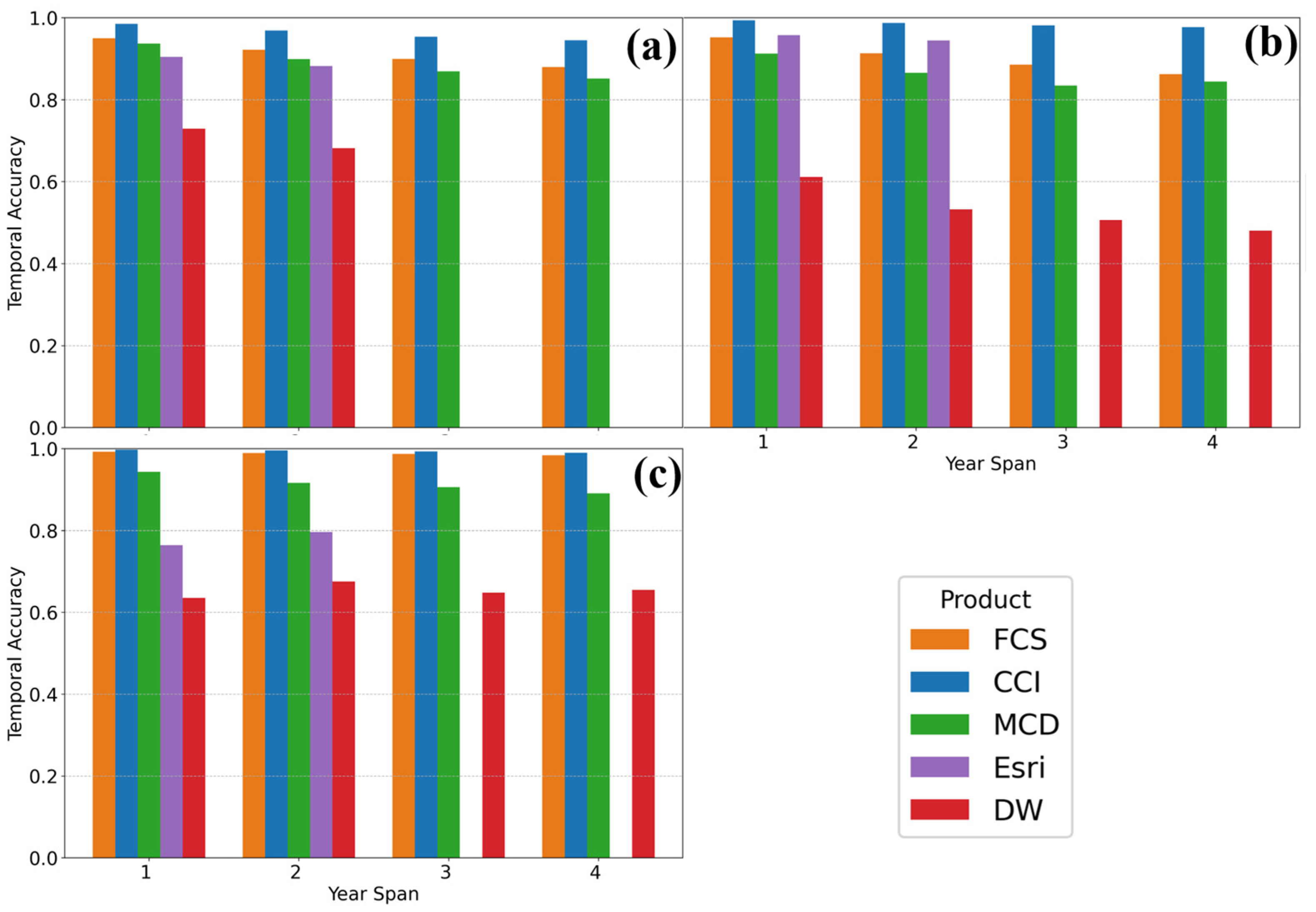
3.2.2. Temporal Accuracy
- (1)
- Randomly select 20% of sample sites and record year-to-year land cover changes. This sampling ratio was determined to balance computational efficiency with statistical representativeness while minimizing spatial autocorrelation through random selection.
- (2)
- For each time span (1–5 years), calculate the correct-match percentage by comparing classification and validation data across all -year intervals.
- (3)
- Average the accuracy across all -year intervals to reduce temporal bias.
- (4)
- Repeat the calculation three times and take the average as the final accuracy.
4. Results
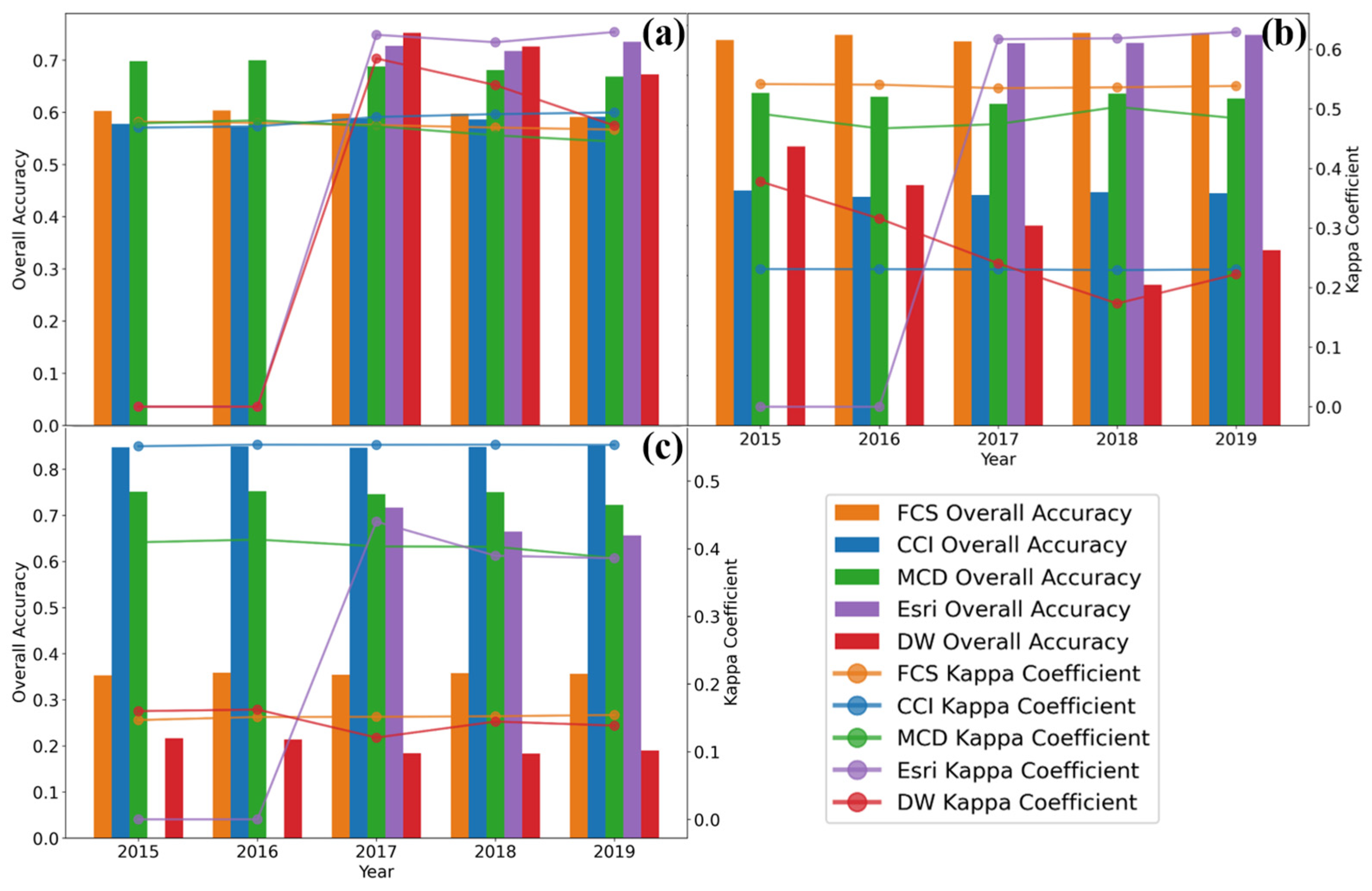
4.1. Classification Accuracy by Year
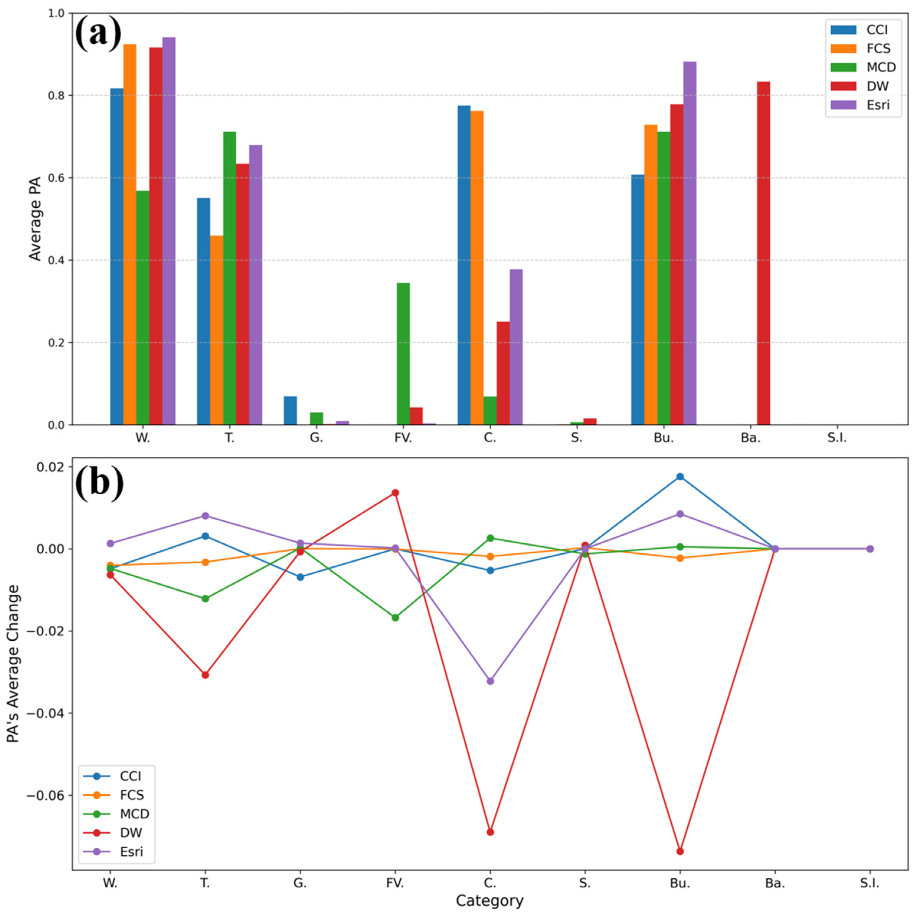
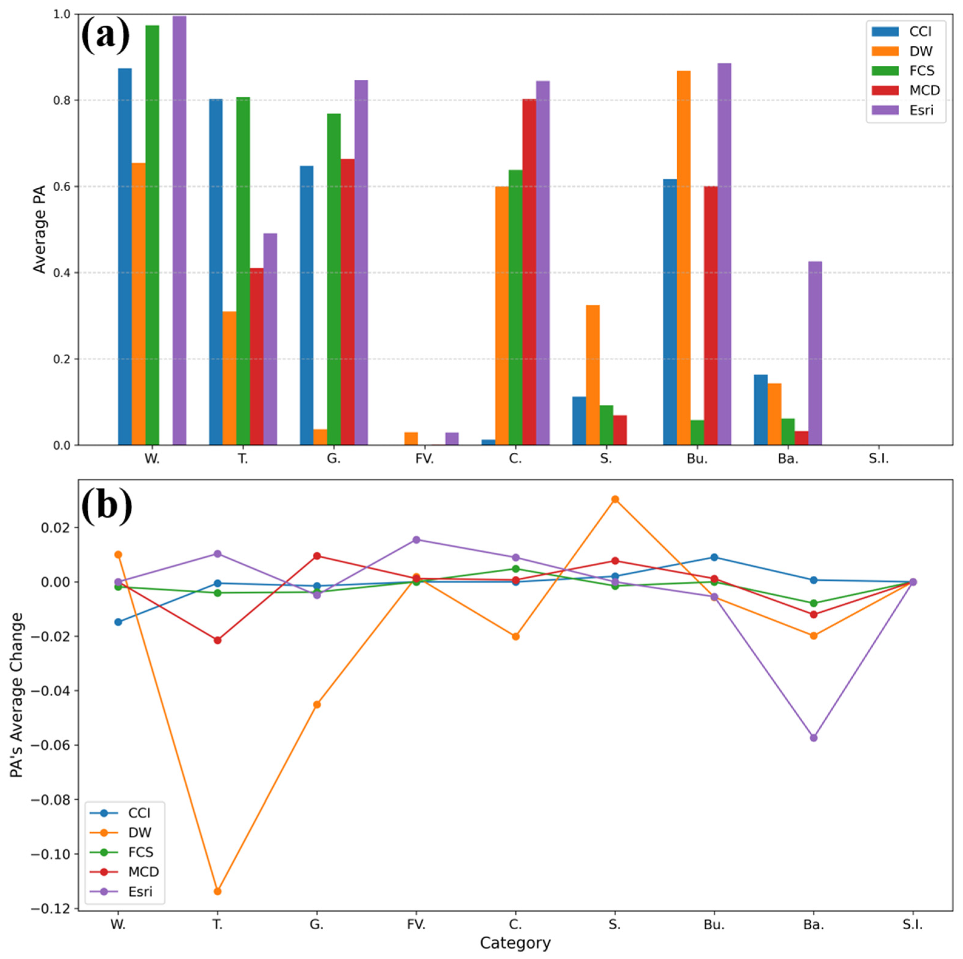
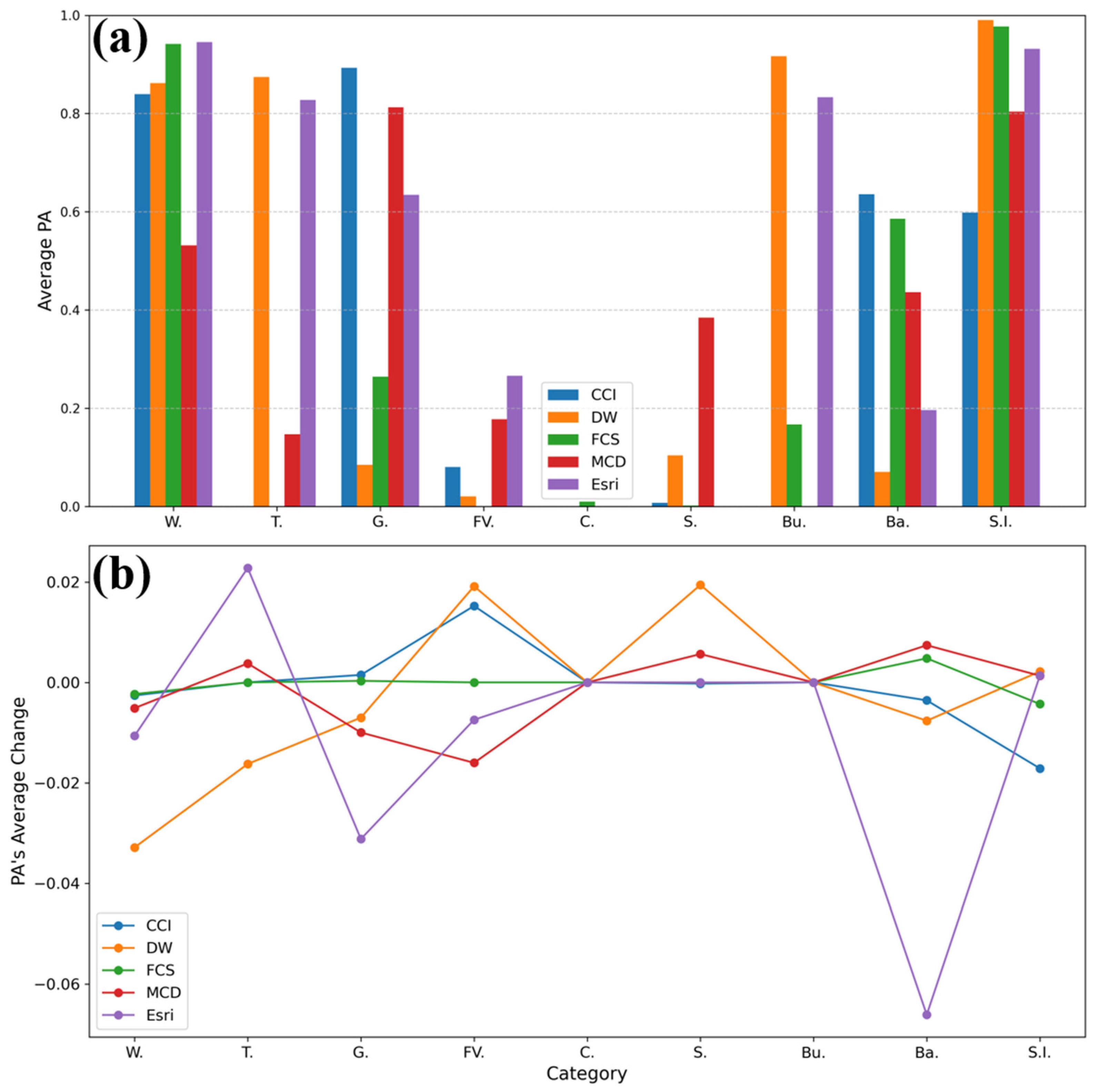
4.2. Comparative Analysis of Different LULC Categories
4.3. Annual Temporal Accuracy
5. Discussion
5.1. Classification Criteria
5.2. Precision Calculation
- (1)
- Dynamic sampling optimization with adaptive window design based on land class spatial heterogeneity and stratified sampling to proportionally allocate samples by type, thereby improving representativeness.
- (2)
- Multi-source data fusion validation by integrating high-resolution imagery, UAV data, and field surveys to construct a spatiotemporally synchronized reference database, thereby reducing validation bias [34].
- (3)
5.3. Differences in the Products
5.3.1. Environmental and Anthropogenic Influences
5.3.2. Impact of Data Sources and Sensor Resolution
5.3.3. Limitations of Classification Algorithms
- (1)
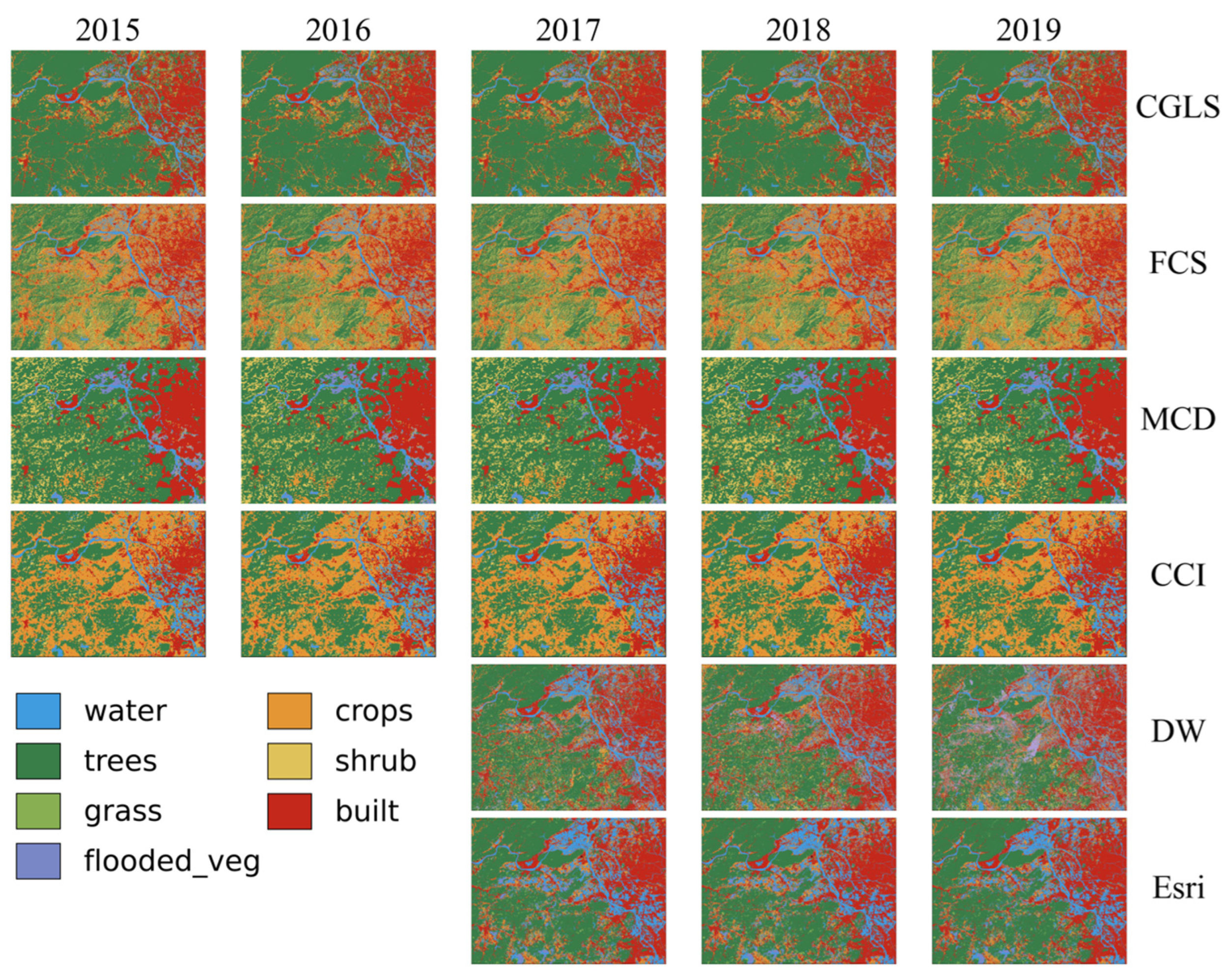
- The Integration of Multi-Source Remote Sensing Data: Combine optical, radar, and LiDAR data to improve the detection of diverse land cover types under varying environmental conditions. Develop adaptive classification frameworks that incorporate local land cover characteristics. For example, in the GHMA, urban expansion patterns can be better captured by integrating high-resolution optical and radar data to account for frequent cloud cover and rapid changes. Products like FCS and CCI can benefit from such integration to improve their accuracy in complex urban and forested areas.
- (2)
- Real-Time Monitoring and Validation: Integrate Unmanned Aerial Vehicles (UAVs) and ground sensor networks to create an air–sky–ground calibration platform. This system would enable the real-time detection of surface changes, helping to reduce update lag errors in time-series monitoring, especially in dynamic regions like the GHMA where urban expansion is rapid. DW’s near-real-time data can be further enhanced through such a platform to provide more accurate and timely updates.
- (3)
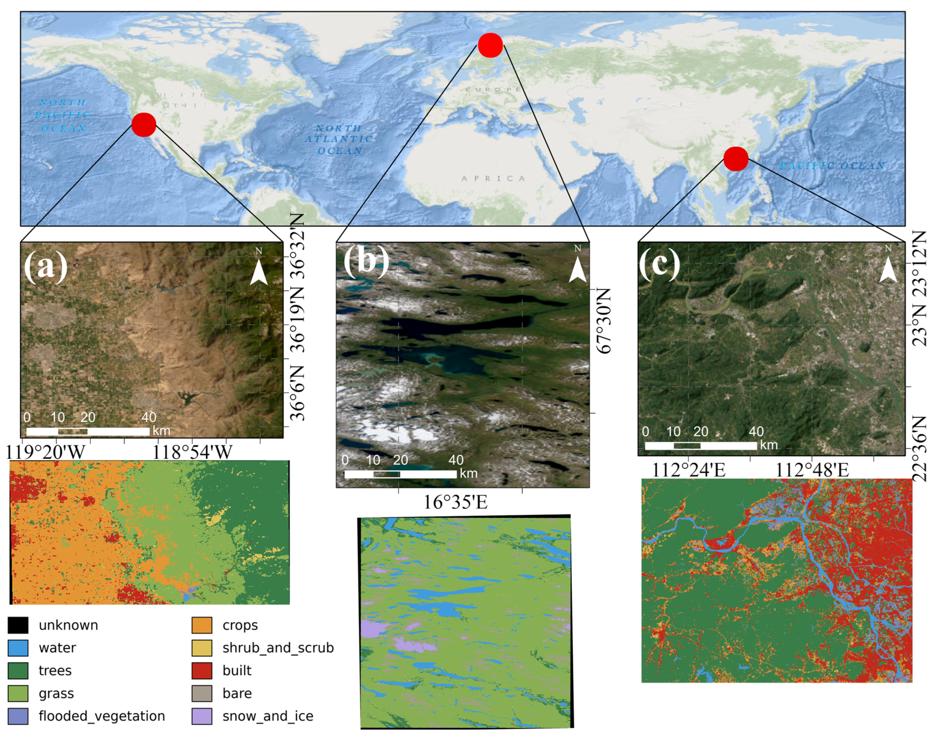
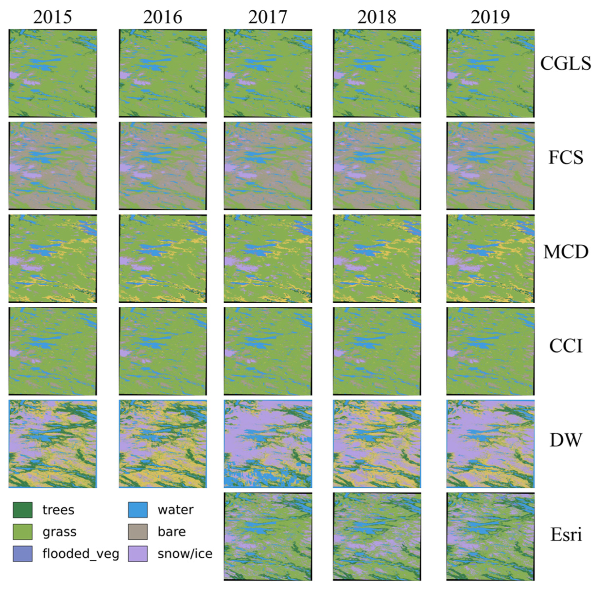
- Advanced Algorithm Development: Improve deep learning-based classification models by enhancing their ability to differentiate between spectrally similar land cover types and accurately delineate boundaries in heterogeneous landscapes. Develop hybrid models that incorporate physical-based and data-driven approaches to improve classification stability and accuracy, particularly in regions with complex land cover such as the Norway–Sweden border. For instance, combining the strengths of FCS’s high resolution with advanced algorithms could lead to the better classification of forest and grassland boundaries in this region.
6. Conclusions
Author Contributions
Funding
Data Availability Statement
Conflicts of Interest
References
- Yang, Y.; Xiao, P.; Feng, X.; Li, H. Accuracy Assessment of Seven Global Land Cover Datasets over China. ISPRS J. Photogramm. Remote Sens. 2017, 125, 156–173. [Google Scholar] [CrossRef] [Scilit]
- Song, X.-P.; Huang, C.; Feng, M.; Sexton, J.O.; Channan, S.; Townshend, J.R. Integrating Global Land Cover Products for Improved Forest Cover Characterization: An Application in North America. Int. J. Digit. Earth 2014, 7, 709–724. [Google Scholar] [CrossRef] [Scilit]
- Xiao, C.; Li, P.; Feng, Z. Agricultural Expansion and Forest Retreat in Mainland Southeast Asia since the Late 1980s. Land Degrad. Dev. 2023, 34, 5606–5621. [Google Scholar] [CrossRef] [Scilit]
- Chinmayi, H.K.; Flynn, K.C.; Ashworth, A.J. Advancements in Remote Sensing Techniques for Earthquake Engineering: A Review. Earthq. Res. Adv. 2024, 4, 100352. [Google Scholar] [CrossRef] [Scilit]
- Thackway, R.; Lymburner, L.; Guerschman, J.P. Dynamic Land Cover Information: Bridging the Gap between Remote Sensing and Natural Resource Management. Ecol. Soc. 2013, 18, 2. [Google Scholar] [CrossRef] [Scilit]
- Yang, G.; Fang, S.; Gong, W.; Zhao, Y.; Ge, M. Evaluating the Reliability of Time Series Land Cover Maps by Exploiting the Hidden Markov Model. Stoch. Environ. Res. Risk Assess. 2021, 35, 881–892. [Google Scholar] [CrossRef] [Scilit]
- Tsutsumida, N.; Comber, A.J. Measures of Spatio-Temporal Accuracy for Time Series Land Cover Data. Int. J. Appl. Earth Obs. Geoinf. 2015, 41, 46–55. [Google Scholar] [CrossRef] [Scilit]
- Herold, M.; Mayaux, P.; Woodcock, C.E.; Baccini, A.; Schmullius, C. Some Challenges in Global Land Cover Mapping: An Assessment of Agreement and Accuracy in Existing 1 Km Datasets. Remote Sens. Environ. 2008, 112, 2538–2556. [Google Scholar] [CrossRef] [Scilit]
- Tsendbazar, N.E.; De Bruin, S.; Herold, M. Assessing Global Land Cover Reference Datasets for Different User Communities. ISPRS J. Photogramm. Remote Sens. 2015, 103, 93–114. [Google Scholar] [CrossRef] [Scilit]
- Moody, A.; Woodcock, C.E. Scale-Dependent Errors in the Estimation of Land-Cover Proportions. Implications for Global Land-Cover Datasets. Photogramm. Eng. Remote Sens. 1994, 60, 585–594. [Google Scholar]
- Tudesque, L.; Tisseuil, C.; Lek, S. Scale-Dependent Effects of Land Cover on Water Physico-Chemistry and Diatom-Based Metrics in a Major River System, the Adour-Garonne Basin (South Western France). Sci. Total Environ. 2014, 466–467, 47–55. [Google Scholar] [CrossRef] [Scilit] [PubMed]
- Waśniewski, A.; Hościło, A.; Aune-Lundberg, L. The Impact of Selection of Reference Samples and DEM on the Accuracy of Land Cover Classification Based on Sentinel-2 Data. Remote Sens. Appl. Soc. Environ. 2023, 32, 101035. [Google Scholar] [CrossRef] [Scilit]
- Abercrombie, S.P.; Friedl, M.A. Improving the Consistency of Multitemporal Land Cover Maps Using a Hidden Markov Model. IEEE Trans. Geosci. Remote Sens. 2016, 54, 703–713. [Google Scholar] [CrossRef] [Scilit]
- Yang, H.; Li, S.; Chen, J.; Zhang, X.; Xu, S. The Standardization and Harmonization of Land Cover Classification Systems towards Harmonized Datasets: A Review. ISPRS Int. J.-Geo-Inf. 2017, 6, 154. [Google Scholar] [CrossRef] [Scilit]
- Liu, H.; Gong, P.; Wang, J.; Clinton, N.; Bai, Y.; Liang, S. Annual Dynamics of Global Land Cover and Its Long-Term Changes from 1982 to 2015. Earth Syst. Sci. Data 2020, 12, 1217–1243. [Google Scholar] [CrossRef] [Scilit]
- Fritz, S.; See, L.; McCallum, I.; Schill, C.; Obersteiner, M.; Van Der Velde, M.; Boettcher, H.; Havlík, P.; Achard, F. Highlighting Continued Uncertainty in Global Land Cover Maps for the User Community. Environ. Res. Lett. 2011, 6, 044005. [Google Scholar] [CrossRef] [Scilit]
- Zhang, X.; Zhao, T.; Xu, H.; Liu, W.; Wang, J.; Chen, X.; Liu, L. GLC_FCS30D: The First Global 30 m Land-Cover Dynamics Monitoring Product with a Fine Classification System for the Period from 1985 to 2022 Generated Using Dense-Time-Series Landsat Imagery and the Continuous Change-Detection Method. Earth Syst. Sci. Data 2024, 16, 1353–1381. [Google Scholar] [CrossRef] [Scilit]
- Karra, K.; Kontgis, C.; Statman-Weil, Z.; Mazzariello, J.C.; Mathis, M.; Brumby, S.P. Global Land Use/Land Cover with Sentinel 2 and Deep Learning. In Proceedings of the 2021 IEEE International Geoscience and Remote Sensing Symposium IGARSS, Brussels, Belgium, 11–16 July 2021; pp. 4704–4707. [Google Scholar]
- Sulla-Menashe, D.; Gray, J.M.; Abercrombie, S.P.; Friedl, M.A. Hierarchical Mapping of Annual Global Land Cover 2001 to Present: The MODIS Collection 6 Land Cover Product. Remote Sens. Environ. 2019, 222, 183–194. [Google Scholar] [CrossRef] [Scilit]
- Liu, X.; Yu, L.; Si, Y.; Zhang, C.; Lu, H.; Yu, C.; Gong, P. Identifying Patterns and Hotspots of Global Land Cover Transitions Using the ESA CCI Land Cover Dataset. Remote Sens. Lett. 2018, 9, 972–981. [Google Scholar] [CrossRef] [Scilit]
- Mousivand, A.; Arsanjani, J.J. Insights on the Historical and Emerging Global Land Cover Changes: The Case of ESA-CCI-LC Datasets. Appl. Geogr. 2019, 106, 82–92. [Google Scholar] [CrossRef] [Scilit]
- Brown, C.F.; Brumby, S.P.; Guzder-Williams, B.; Birch, T.; Hyde, S.B.; Mazzariello, J.; Czerwinski, W.; Pasquarella, V.J.; Haertel, R.; Ilyushchenko, S.; et al. Dynamic World, Near Real-Time Global 10 m Land Use Land Cover Mapping. Sci. Data 2022, 9, 251. [Google Scholar] [CrossRef] [Scilit]
- Buchhorn, M.; Lesiv, M.; Tsendbazar, N.-E.; Herold, M.; Bertels, L.; Smets, B. Copernicus Global Land Cover Layers—Collection 2. Remote Sens. 2020, 12, 1044. [Google Scholar] [CrossRef] [Scilit]
- Bestelmeyer, B.T.; Wiens, J.A. Local and Regional-scale Responses of Ant Diversity to a Semiarid Biome Transition. Ecography 2001, 24, 381–392. [Google Scholar] [CrossRef] [Scilit]
- Li, W.; Fan, J.; Li, Z.; Wang, C.; Zhang, X.; Duan, J. Improved Adaptive Neuro-fuzzy Inference System with Bacterial Foraging Optimization Algorithm for Suspended Sediment Concentration Estimation. J. Interll. Fuzzy Syst. 2024, 46, 3945–3961. [Google Scholar] [CrossRef] [Scilit]
- Wang, C.; Zhu, C.; Wang, X.; Tu, W.; Li, Q. A New Object-Oriented SAR Interferometry Framework for Monitoring Urban Deformation. IEEE Trans. Geosci. Remote Sens. 2024, 62, 5227011. [Google Scholar] [CrossRef] [Scilit]
- Xie, S.; Liu, L.; Zhang, X.; Chen, X. Annual Land-Cover Mapping Based on Multi-Temporal Cloud-Contaminated Landsat Images. Int. J. Remote Sens. 2019, 40, 3855–3877. [Google Scholar] [CrossRef] [Scilit]
- Wang, X.; Cao, J.; Liu, J.; Li, X.; Wang, L.; Zuo, F.; Bai, M. Improving the Interpretability and Reliability of Regional Land Cover Classification by U-Net Using Remote Sensing Data. Chin. Geogr. Sci. 2022, 32, 979–994. [Google Scholar] [CrossRef] [Scilit]
- Higgins, S.I.; Conradi, T.; Muhoko, E. Shifts in Vegetation Activity of Terrestrial Ecosystems Attributable to Climate Trends. Nat. Geosci. 2023, 16, 147–153. [Google Scholar] [CrossRef] [Scilit]
- Zheng, Q.-H.; Chen, W.; Li, S.-L.; Yu, L.; Zhang, X.; Liu, L.-F.; Singh, R.P.; Liu, C.-Q. Accuracy Comparison and Driving Factor Analysis of LULC Changes Using Multi-Source Time-Series Remote Sensing Data in a Coastal Area. Ecol. Inform. 2021, 66, 101457. [Google Scholar] [CrossRef] [Scilit]
- Alganci, U. Dynamic Land Cover Mapping of Urbanized Cities with Landsat 8 Multi-Temporal Images: Comparative Evaluation of Classification Algorithms and Dimension Reduction Methods. ISPRS Int. J.-Geo-Inf. 2019, 8, 139. [Google Scholar] [CrossRef] [Scilit]
- Kim, D.-H.; Johnson, J.M.; Clarke, K.C.; McMillan, H.K. Untangling the Impacts of Land Cover Representation and Resampling in Distributed Hydrological Model Predictions. Environ. Model. Softw. 2024, 172, 105893. [Google Scholar] [CrossRef] [Scilit]
- Wang, H.; Yan, H.; Hu, Y.; Xi, Y.; Yang, Y. Consistency and Accuracy of Four High-Resolution LULC Datasets—Indochina Peninsula Case Study. Land 2022, 11, 758. [Google Scholar] [CrossRef] [Scilit]
- Qu, L.; Chen, Z.; Li, M.; Zhi, J.; Wang, H. Accuracy Improvements to Pixel-Based and Object-Based LULC Classification with Auxiliary Datasets from Google Earth Engine. Remote Sens. 2021, 13, 453. [Google Scholar] [CrossRef] [Scilit]
- Parracciani, C.; Gigante, D.; Mutanga, O.; Bonafoni, S.; Vizzari, M. Land Cover Changes in Grassland Landscapes: Combining Enhanced Landsat Data Composition, LandTrendr, and Machine Learning Classification in Google Earth Engine with MLP-ANN Scenario Forecasting. GIScience Remote Sens. 2024, 61, 2302221. [Google Scholar] [CrossRef] [Scilit]
- Huang, X.; Ibrahim, M.M.; Luo, Y.; Jiang, L.; Chen, J.; Hou, E. Land Use Change Alters Soil Organic Carbon: Constrained Global Patterns and Predictors. Earth’s Future 2024, 12, e2023EF004254. [Google Scholar] [CrossRef] [Scilit]
- Fu, P.; Weng, Q. A Time Series Analysis of Urbanization Induced Land Use and Land Cover Change and Its Impact on Land Surface Temperature with Landsat Imagery. Remote Sens. Environ. 2016, 175, 205–214. [Google Scholar] [CrossRef] [Scilit]
- Kaiser, E.A.; Rolim, S.B.A.; Grondona, A.E.B.; Hackmann, C.L.; De Marsillac Linn, R.; Käfer, P.S.; Da Rocha, N.S.; Diaz, L.R. Spatiotemporal Influences of LULC Changes on Land Surface Temperature in Rapid Urbanization Area by Using Landsat-TM and TIRS Images. Atmosphere 2022, 13, 460. [Google Scholar] [CrossRef] [Scilit]
- Zheng, H.; Chen, Y.; Pan, W.; Cai, Y.; Chen, Z. Impact of Land Use/Land Cover Changeson the Thermal Environment in Urbanization: A Case Study of the Natural Wetlands DistributionArea in Minjiang River Estuary, China. Pol. J. Environ. Stud. 2019, 28, 3025–3041. [Google Scholar] [CrossRef] [Scilit]
- Sagan, V.; Peterson, K.T.; Maimaitijiang, M.; Sidike, P.; Sloan, J.; Greeling, B.A.; Maalouf, S.; Adams, C. Monitoring Inland Water Quality Using Remote Sensing: Potential and Limitations of Spectral Indices, Bio-Optical Simulations, Machine Learning, and Cloud Computing. Earth-Sci. Rev. 2020, 205, 103187. [Google Scholar] [CrossRef] [Scilit]
- Arvor, D.; Durieux, L.; Andrés, S.; Laporte, M.-A. Advances in Geographic Object-Based Image Analysis with Ontologies: A Review of Main Contributions and Limitations from a Remote Sensing Perspective. ISPRS J. Photogramm. Remote Sens. 2013, 82, 125–137. [Google Scholar] [CrossRef] [Scilit]



| Product Name | Abbreviation | Temporal Characteristics | Spatial Characteristics | Criteria for Classification | |||
|---|---|---|---|---|---|---|---|
| Year of Coverage | Calculation Period | Resolution | Scope of Coverage | Classification Method | Land Cover Categories | ||
| CGLS-LC100 | CGLS | 2015–2019 | 1 year | 100 | global | Supervised Classification (Random Forest, Decision Tree, etc.) | 10 |
| GLC_FCS30D | FCS | 2015–2021 | 1 year | 30 | 30 | ||
| Esri Land Cover | Esri | 2015–2024 | 1 year | 10 | 10 | ||
| MCD12Q1 | MCD | 2001–2024 | 1 year | 500 | 17 | ||
| ESA CCI | CCI | 1992–2020 | 1 year | 300 | 22 | ||
| Dynamic World | DW | 2015–2024 | 2–5 days | 10 | Convolutional Neural Network (FCNN) | 9 | |
| Dichotomous Phase | ||
|---|---|---|
| Primarily Vegetated | Terrestrial | Cultivated and Managed Terrestrial Areas |
| Natural and Semi-Natural Terrestrial Vegetation | ||
| Aquatic or Regularly Flooded | Cultivated Aquatic or Regularly Flooded Areas | |
| Natural and Semi-Natural Aquatic or Regularly Flooded Vegetation | ||
| Primarily Non-Vegetated | Terrestrial | Artificial Surfaces and Associated Areas |
| Bare Areas | ||
| Aquatic or Regularly Flooded | Artificial Waterbodies, Snow and Ice | |
| Natural Waterbodies, Snow and Ice | ||
| Reclassified Category | CGLS (Validation Dataset) | FCS | CCI | MCD | Esri | DW |
|---|---|---|---|---|---|---|
| Unknown (0) | Unknown (0) | No data (0), filled value (250) | No data (0) | Unclassified (255) | No data (1), clouds (11) | |
| Water (1) | Permanent water bodies (80), oceans, seas (200) | Swamp (181), marsh (182), flooded flat (183), water body (210) | Water bodies (210) | Water bodies (17) | Water (2) | Water (0) |
| Trees (2) | Closed forest, evergreen needle leaf (111), evergreen broad leaf (112), deciduous needle leaf (113), deciduous broad leaf (114), … mixed (115), not matching any of the other definitions (116), evergreen needle leaf (121), evergreen broad leaf (122), deciduous needle leaf (123), deciduous broad leaf (124), mixed (125), open forest, not matching any of the other definitions (126) | Tree cover (12), open evergreen broadleaved forest (51), closed … (52), open deciduous broadleaved forest (61), closed … (62), open evergreen needle-leaved forest (71), closed … (72), open deciduous needle-leaved forest (81), closed … (82), open mixed leaf forest (91), closed mixed leaf forest (92) | Tree or shrub cover (12), mosaic natural vegetation (40), tree cover, broadleaved, evergreen, closed to open (50), … closed (60), … open (61), T. needleleaved, evergreen, closed (70), … open (71), T. needleleaved, deciduous, closed (80), … open (81), T. mixed leaf type (90), mosaic tree and shrub (100), mosaic herbaceous cover (110), sparse vegetation (150), sparse tree (151) | Evergreen needleleaf forests (1), evergreen broadleaf forests (2), deciduous needleleaf forests (3), deciduous broadleaf forests (4), mixed forests (5), savannas (9) | Trees (3) | Trees (1) |
| Grass (3) | Herbaceous vegetation (30) | Grassland (130), sparse herbaceous (153) | Grassland (130), herbaceous cover (11), sparse herbaceous cover (153) | Grasslands (10) | Grass (4) | Grass (2) |
| Flooded_vegetation (4) | Herbaceous wetland (90) | Salt marsh (186), tidal flat (187) | Flooded, fresh or brackish water (160), flooded, saline water (170), fresh/saline/brackish water (180) | Permanent wetlands (11) | Flooded vegetation (5) | Flooded_vegetation (3) |
| Crops (5) | Cultivated and managed vegetation (40) | Rainfed cropland (10), herbaceous cover cropland (11), irrigated cropland (20) | Crop, rainfed (10), crop, irrigated or post-flooding (20) | Croplands (12), natural vegetation mosaics (14) | Crops (6) | Crops (4) |
| Shrub and scrub (6) | Shrubs (20) | Shrubland (120), evergreen shrubland (121), deciduous shrubland (122), sparse shrubland (152), sparse herbaceous (153), mangrove (185) | Shrubland (120), evergreen shrubland (121), deciduous shrubland (122), sparse vegetation (150), sparse tree (151), sparse shrub (152), sparse herbaceous cover (153) | Closed shrublands (6), open shrublands (7), woody savannas (8) | Scrub (7) | Shrub_and_scrub (5) |
| Built (7) | Urban/built up (50) | Impervious surfaces (190) | Urban areas (190) | Urban and built-up lands (13) | Built (8) | Built (6) |
| Bare (8) | Moss and lichen (100), bare vegetation (60) | Lichens and mosses (140), sparse vegetation (150), saline (184), bare areas (200), consolidated bare areas (201), unconsolidated bare areas (202) | Lichens and mosses (140), bare areas (200), consolidated bare areas (201), unconsolidated bare areas (202) | Barren (16) | Bare ground (9) | Bare (7) |
| Snow and ice (9) | Snow and ice (70) | Permanent ice and snow (220) | Permanent snow and ice (220) | Permanent snow and ice (15) | Snow/ice (10) | Snow_and_ice (8) |
Disclaimer/Publisher’s Note: The statements, opinions and data contained in all publications are solely those of the individual author(s) and contributor(s) and not of MDPI and/or the editor(s). MDPI and/or the editor(s) disclaim responsibility for any injury to people or property resulting from any ideas, methods, instructions or products referred to in the content. |
© 2025 by the authors. Licensee MDPI, Basel, Switzerland. This article is an open access article distributed under the terms and conditions of the Creative Commons Attribution (CC BY) license (https://creativecommons.org/licenses/by/4.0/).
Share and Cite
Li, P.; Wang, Y.; Wang, C.; Tian, L.; Lin, M.; Xu, S.; Zhu, C. A Comparison of Recent Global Time-Series Land Cover Products. Remote Sens. 2025, 17, 1417. https://doi.org/10.3390/rs17081417
Li P, Wang Y, Wang C, Tian L, Lin M, Xu S, Zhu C. A Comparison of Recent Global Time-Series Land Cover Products. Remote Sensing. 2025; 17(8):1417. https://doi.org/10.3390/rs17081417
Chicago/Turabian StyleLi, Peilin, Yan Wang, Chisheng Wang, Lin Tian, Meijiao Lin, Siyao Xu, and Chuanhua Zhu. 2025. "A Comparison of Recent Global Time-Series Land Cover Products" Remote Sensing 17, no. 8: 1417. https://doi.org/10.3390/rs17081417
APA StyleLi, P., Wang, Y., Wang, C., Tian, L., Lin, M., Xu, S., & Zhu, C. (2025). A Comparison of Recent Global Time-Series Land Cover Products. Remote Sensing, 17(8), 1417. https://doi.org/10.3390/rs17081417