Article

Dynamic Task Planning Method for Multi-Source Remote Sensing Satellite Cooperative Observation in Complex Scenarios

State Key Laboratory of Information Engineering in Surveying, Mapping and Remote Sensing, Wuhan University, 129 Luoyu Road, Wuhan 430079, China
*
Author to whom correspondence should be addressed.
Remote Sens. 2024, 16(4), 657; https://doi.org/10.3390/rs16040657
Submission received: 26 December 2023 / Revised: 1 February 2024 / Accepted: 8 February 2024 / Published: 10 February 2024
(This article belongs to the Special Issue Deep Learning for the Analysis of Multi-/Hyperspectral Images II)

Abstract

:
As the number and variety of remote sensing satellites continue to grow, user demands are becoming increasingly complex and diverse. Concurrently, there is an escalating requirement for timeliness in satellite observations, thereby augmenting the complexity of task processing and resource allocation. In response to these challenges, this paper proposes an innovative method for dynamic task planning in multi-source remote sensing satellite cooperative observations tailored to complex scenarios. In the task processing phase, this study develops a preprocessing model suitable for various types of targets, enabling the decomposition of complex scenes into multiple point targets for independent satellite observation, thereby reducing the complexity of the problem. In the resource allocation phase, a dynamic task planning algorithm for multi-satellite cooperative observation is designed to achieve dynamic and optimized scheduling of the processed point targets, catering to the needs of multi-source remote sensing satellites. Empirical validation demonstrated that this method effectively implements dynamic adjustment plans for point targets, comprehensively optimizing the number of observation targets, computation time, task priority, and satellite resource utilization, significantly enhancing the dynamic observation efficiency of remote sensing satellites.

1. Introduction

In recent years, there has been a significant surge in both the number and variety of remote sensing satellites, which has led to their widespread utilization across a multitude of fields [1]. The synergy achieved through the cooperative observation capabilities of these multiple remote sensing satellites has facilitated rapid global revisits, effectively catering to the requirements of a wide array of complex observational tasks [2]. Nonetheless, the increasing diversity of satellite resources, coupled with the growing complexity of task demands and the escalated expectations for promptness in mass service delivery, have concurrently amplified the complexities involved in task analysis and satellite resource management. This escalation in complexity presents notable challenges in delivering real-time and efficient responses to the dynamic evolving service demands associated with diverse task types.
Satellite mission planning is a vital method for the optimal allocation of satellite resources to meet mission demands. Extensive research on this topic has been conducted by scholars both domestically and internationally. Through the analysis of various constraints in Earth observation satellites, including satellite resources, observational tasks, and space environment factors, a diverse range of mission planning models has been developed. These models include constraint satisfaction models, mathematical planning models, and graph theory-based models [3,4,5,6]. In terms of model solving approaches, a suite of algorithms has been established, encompassing deterministic algorithms such as branch and bound and integer programming, as well as heuristic algorithms such as tabu search, simulated annealing, and mosquito swarm algorithms [7,8,9,10,11]. These methods are effective at addressing both single satellite mission planning and multi-satellite collaborative task planning issues [12,13,14,15]. Current research on single and multi-satellite observation mission planning has culminated in a relatively mature set of methodologies.
However, a deeper analysis of the earth observation service process of remote sensing satellites reveals that existing methods still have limitations in terms of integrated optimization scheduling for various complex target types. For example, when a user submits an earthquake disaster task, they need to obtain data from the entire range of the affected area to gain an overall understanding of the disaster situation, as well as real-time monitoring data from the affected area to understand the disaster changes in the affected area. At the same time, they also need to obtain optical and SAR images of the affected area to conduct a more comprehensive analysis of the affected area through multi-source data fusion. Therefore, when scheduling resources for such tasks, we need to consider not only the use of multiple satellites with the same attributes to concatenate and observe the area, but also using multiple satellites to periodically observe the area at similar times. Moreover, we also need to consider using satellites with different types of sensors to observe the area. These requirements have created multiple one-to-many relationships between the task and satellite resources, increasing the complexity of the problem. When different users simultaneously propose multiple complex scene objectives, the difficulty of the problem will further increase.
With the continuous increase in the number and quality of satellite resources, the complexity of user demands and the timeliness requirements for remote sensing information services are also steadily increasing. Therefore, there is an urgent need for an integrated and comprehensive analysis of different types of complex targets, coupled with the inclusion of dynamic planning capabilities in the mission planning phase, to fulfill the demand for efficient and dynamic observation.
Considering the inherent challenges in complex scenarios, this paper introduces an innovative method for dynamic task planning in multi-source remote sensing satellite cooperative observation. During the task processing phase, a preprocessing model suitable for various types of complex tasks is constructed, effectively decomposing four observation modes. This decomposition simplifies the problem and enhances the efficiency of data collection while avoiding resource conflicts, interference, and waste. In terms of resource scheduling, we have developed a dynamic planning method for decomposed point targets, optimizing the coordination of user objectives and achieving an integrated optimization of the number of observation targets, computation time, and task priority. This method, through service mode decomposition and multi-satellite cooperative observation task planning, effectively addresses complex scenarios. This approach is applicable to a variety of intricate environments, optimizes the allocation of space and ground resources, and provides technical support for intelligent remote sensing satellite observations.

2. Materials and Methods

2.1. Method Framework Design

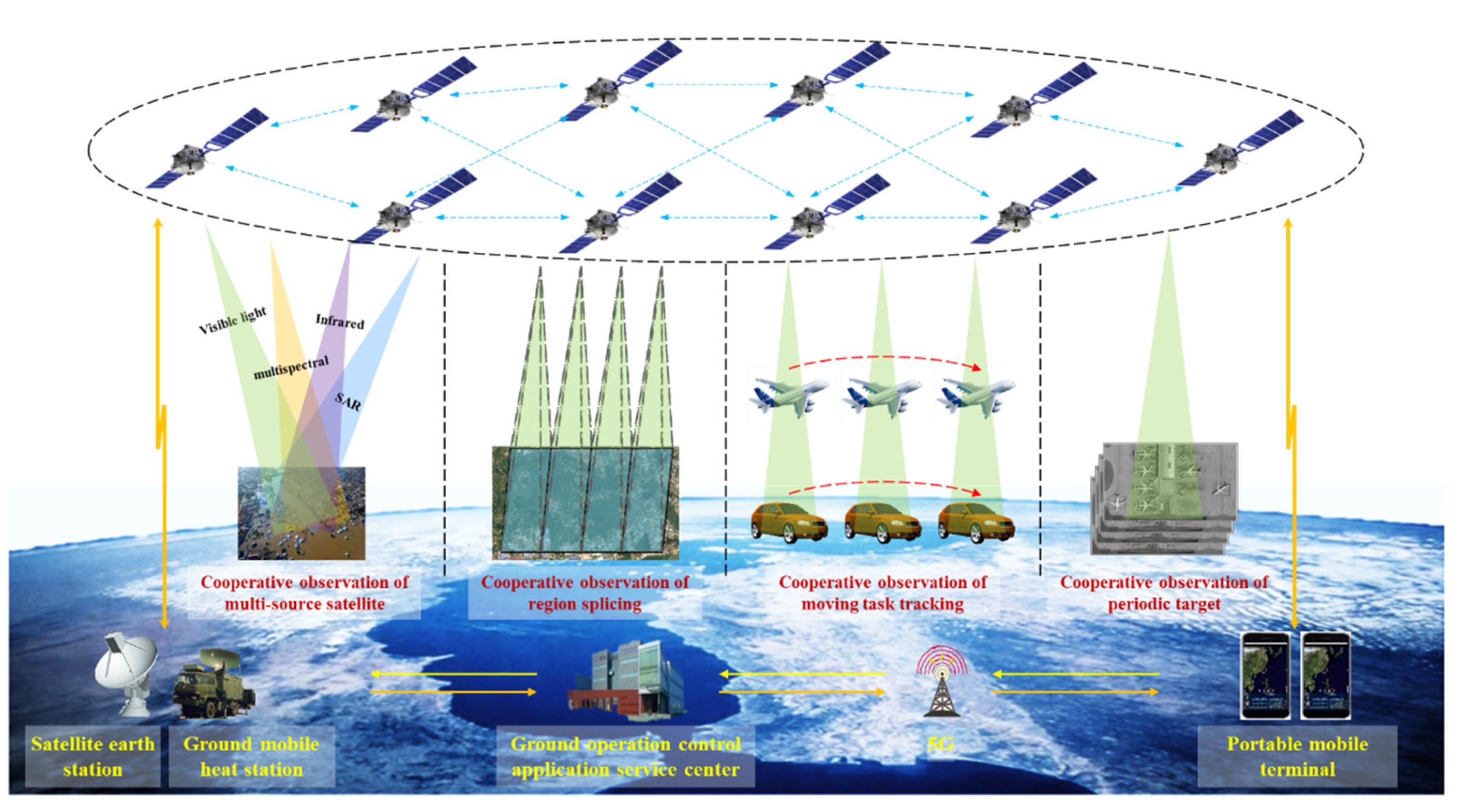
The architecture for dynamic task planning in multi-source satellite cooperative observation targeting complex tasks is presented in Figure 1. The architecture is designed to effectively manage and coordinate the observation efforts of multiple satellites. This architecture is tailored to address the intricacies and challenges of complex observational tasks. It involves two key stages: task processing and resource allocation.
In the task processing stage, complex scenarios are analyzed in detail to understand their patterns and intricacies. This detailed analysis leads to the decomposition of complex tasks into multiple point targets. These point targets are structured such that they can be observed individually by satellites in a single pass. This breakdown simplifies the observation process and makes it more manageable.
In the resource allocation stage, a universal task planning model and its corresponding solving algorithm are first established, followed by the development of a planning scheme merging model and its solving algorithm. These models and algorithms are utilized for detailed task planning of the decomposed point targets. When confronted with dynamically changing targets, the same models and algorithms are applied to compute and formulate a task planning scheme for the newly added point targets. Subsequently, the existing planning scheme for unobserved original targets at the current time is merged with the plan for the newly added targets. This process includes the exclusion of targets that present scheduling conflicts with based on task priority, thereby forming an updated observational plan for the targets.

2.2. Task Preprocessing Method

Remote sensing satellite information services integrate processes such as task decomposition, planning, data processing, and terminal distribution. The observation requirements and processing procedures vary for different types of targets. To achieve unified optimization and scheduling for various target types, based on the category of tasks and observation requirements, we categorize remote sensing satellite observation modes into four types: multisource remote sensing satellite cooperative observation mode, regional stitching observation mode, moving target tracking observation mode, and periodic target observation mode. The application scenarios of each observation mode are shown in Figure 2.
The specific definitions of each observation mode are as follows:
  • Multi-source satellite cooperative observation mode
This mode is primarily aimed at targets in the same area with diverse types of payload observation requirements. Multiple remote sensing satellites equipped with different types of payloads collaboratively observe the area, providing basic data for multisource remote sensing image fusion processing of the target.
  • Regional stitching cooperative observation mode
This mode is used mainly for large-area targets that cannot be fully captured in a single satellite pass. Multiple remote sensing satellites with similar payloads are needed to collaboratively observe the target area, shortening the coverage cycle and increasing the target coverage rate.
  • Moving target tracking cooperative observation mode
This mode is used primarily for aerial/ground moving targets. It involves predicting the possible range of the moving target and using multiple remote sensing satellites with the same attributes for relay observation of the target, achieving tracking and analysis of the moving target.
  • Periodic target cooperative observation mode
This mode is used mainly for targets in the same area for which long-term or periodic observations are needed. Multiple remote sensing satellites with the same attributes continuously observe the target to acquire time-series image data within the same scene, realizing change perception analysis of periodic targets.
When users submit complex task requirements, we first classify the tasks into one or more of the above observation modes. Then, we apply the decomposition methods of the corresponding observation modes to process the tasks, breaking down complex tasks into multiple point targets that can be completely observed by a single satellite pass, thus providing fundamental support for subsequent optimized scheduling.
The task processing methods for the four observation modes are as follows:
(1)
Task decomposition for the multi-source remote sensing satellite cooperative observation mode
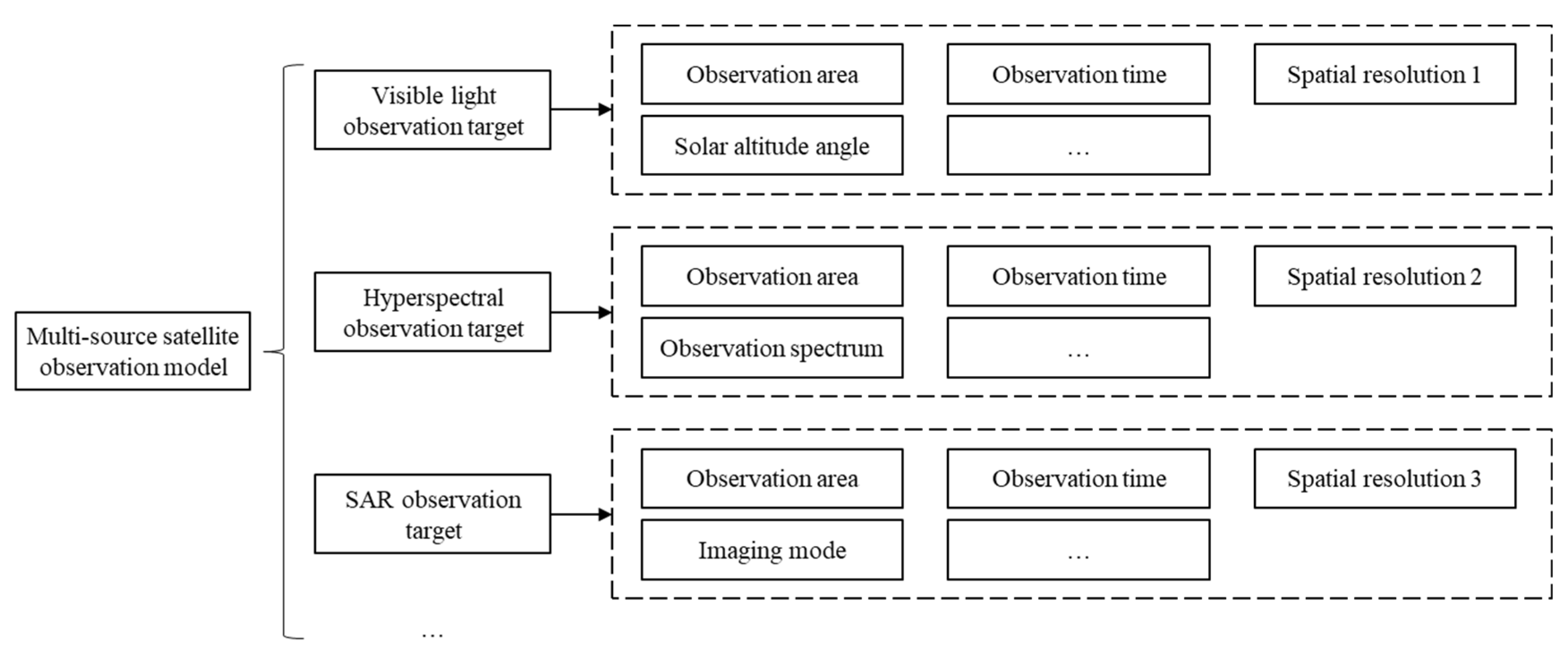
The mode primarily involves multiple remote sensing satellites with different types of payloads observing the same target. Our approach to these targets involves decomposing the sensor requirements of the target into several targets with only a single payload requirement. As shown in Figure 3, we first decompose a complex task into multiple sub-tasks with the same observation area and time range but different payload requirements. Then, we add specific task description conditions for each sub-task according to the type of payload, such as considering the solar elevation angle for visible light observation tasks, to complete the task decomposition.
(2)
Task decomposition for the regional stitching cooperative observation mode
This mode primarily involves multiple remote sensing satellites with the same attributes performing stitching observation of the same area in different observation strips. For such targets, our approach involves decomposition of the regional scope of the target into several point targets that can be completely covered in a single pass by a single satellite. As shown in Figure 4, we first decompose a large-area target into multiple sub-tasks with the same observation time ranges and spatial resolution requirements but different geographical locations that can be fully covered by a single satellite pass. Then, we add other task description information for each sub-task according to the payload type to complete the task decomposition.
(3)
Task decomposition for the moving target tracking cooperative observation mode
This mode primarily involves multiple remote sensing satellites with the same attributes performing relay observations of moving targets. For these targets, our approach involves decomposing the observation time and range of the target based on prior information (such as the initial position, speed, and direction of the moving target) and continuously predicting the possible area where the moving target might appear. As shown in Figure 5, we first predict the movement range of the target within future period 1 based on prior information, designating period 1 as the observation time range and forming the observation sub-task for period 1. Then, based on the payload type for target observation, we add task description conditions to form independent observation tasks. Subsequently, satellite resources are utilized for task planning, data acquisition, and processing of the observation sub-task for period 1, extracting information such as the position and attitude of the moving target, and solving for the target’s position, speed, and direction combined with prior information. Based on the observation results of period 1, we predict the movement range of the moving target within future period 2, forming the observation sub-task for period 2. The process involves continuously updating predictions based on observation results, forming a chain of consecutive observation tasks.
(4)
Task decomposition for periodic target cooperative observation mode
The mode primarily involves the use of multiple remote sensing satellites possessing homogeneous attributes to conduct prolonged or cyclic monitoring of fixed scenes. In addressing such targets, our methodology entails the segmentation of the target’s observation timeframe, thereby decomposing it into multiple point targets, each capable of being comprehensively observed in a single pass by an individual satellite. The detailed procedural flowchart is shown in Figure 6. Initially, based on the requirements of the observation time intervals, targets within a fixed scene are dissected into several sub-tasks, each characterized by distinct observation time spans. Subsequently, for each sub-task, supplementary task descriptive information is appended in accordance with the type of payload, thus culminating in the fragmentation of the task.

2.3. Resource Allocation Method

Following the preprocessing of complex observation tasks, data are decomposed into multiple point targets, each of which can be observed by a single satellite during a single pass. Given the diverse demands of these point targets on satellite resources, we are faced with the challenge of optimizing resource allocation among numerous targets and satellites. Moreover, due to the ever-changing user requirements and the increasing demand for timeliness in remote sensing information services, traditional ground-based centralized task planning methods are no longer sufficient to meet the needs of high-timeliness observations. Therefore, this paper proposes a dynamic task planning method for multi-satellite cooperative observation. This method not only addresses the resource optimization scheduling issues between multiple satellites and targets but also allows for timely updates to the planning schemes for newly added user targets.
The primary concept of the multi-satellite cooperative observation dynamic task planning method proposed in this paper is as follows: First, we propose a generalized multi-satellite cooperative observation task planning method and a method for merging planning schemes. When users submit task requirements, the generalized task planning method is used to calculate the planning scheme for the current target. When new user requirements arise, the same method is employed to calculate the planning scheme for the additional targets. Subsequently, through the scheme merging method, the newly added task planning scheme is integrated with the original unexecuted planning schemes. During this process, we rely on set constraints and objective functions to eliminate tasks with time conflicts, thus achieving dynamic adjustment of the planning scheme. This method independently plans for newly added tasks, avoids redundant planning calculations for existing tasks, and improves the computational efficiency of dynamic task planning in orbit under limited satellite resources.

2.3.1. Generalized Multi-Satellite Cooperative Observation Task Planning Method

The primary objective of satellite task planning is to optimize the configuration of targets and satellite resources. As multiple remote sensing satellites with similar attributes may have effective observation windows for the same point target, and a single satellite at different yaw angles may also have effective windows for various point targets, these issues lead to a complex many-to-many relationships between satellites and targets. To enhance the efficiency of task planning and reduce the waste of satellite resources, we propose a generalized method for multi-satellite cooperative observation task planning. By setting specific constraints and objective functions, the method provides a detailed description of the problem, ensuring that the planning scheme meets the requirements of satellites, targets, and the environment.
The constraints adopted in this paper include the following:
(1)
Time window constraint
To obtain data for a target, it is imperative to ensure that a satellite has a visible time window for that target. Due to the limitations of observation time and satellite swath width, not all tasks involve effective time windows; hence, we set this constraint to exclude targets without effective windows. The time window constraint is defined as the necessity for a target to have an effective time window, meaning that the set of time windows for the target cannot be empty (Equation (1)).
  1 i l = 1 k N T l , 1 j m , T W i j
where k is the number of user target uploads. l = 1 k N T l is the total number of user targets uploaded for the k-th time. i is the serial number of the user target. m is the number of satellite resources. T W i j k is the time window for the j-th satellite to reach the i-th target.
(2)
Observation time constraint
When users submit observation requirements, they often have specific demands regarding the observation time. Considering the varying visible time windows of satellites for targets at different times, we set an observation time constraint to ensure that the final planning scheme meets these observation time requirements. Specifically, a task must be planned after the user-required observation start time and before the observation end time. That is, the start time of the task must be later than the prescribed observation start time (Equation (2)), and the end time must be earlier than the prescribed observation end time (Equation (3)).
  1 j m , 1 l N T W j k , s t a l j k > S T A R T
  1 j m , 1 l N T W j k , e n d l j k < E N D
where N T W j k is the effective time window number of the j-th satellite to the k-th upload target. s t a l j k is the observation start time of the j-th satellite to the l-th effective time window of the k-th upload target. S T A R T is the planned start time. e n d l j k is the observation end time of the j-th satellite to the l-th effective time window of the k-th upload target. E N D is the planned end time.
(3)
Satellite resource uniqueness constraint
This constraint pertains to limiting the number of targets observed by a satellite at the same time. As satellites may observe different targets at the same time with varying yaw angles, this could lead to conflicts in timing. Therefore, we established the satellite resource uniqueness constraint, stipulating that a single satellite can observe only one target at any given time. Specifically, the start time of the l-th target observed by the j-th satellite must be later than the end time of the (l − 1)-th target observed by the j-th satellite (Equation (4)).
  1 j m , 1 l N T W j k , s t a l j k > e n d l 1 j k
(4)
Observation target uniqueness constraint
Given that complex targets are decomposed into multiple point targets during the task processing stage, each point target in the planning scheme requires only one effective time window. As there may be scenarios where one or multiple satellites have several time windows for the same target, it is necessary to impose this constraint to limit the number of observations for the same target. In particular, each target can be observed only once, meaning that the i-th target appears no more than once in the final planning scheme (Equation (5)).
  1 x j = 1 m N T W j k , 1 y j = 1 m N T W j k   a n d   y x , T I x k T I y k
where j = 1 m N T W j k is the total number of effective time windows of all satellites for the k-th upload task. x and y represent any two different time windows. T I x k is the target corresponding to the x-th time window in the k-th upload task. T I y k is the target corresponding to the y-th time window in the k-th upload task.
(5)
Cloud cover constraint
When optical satellites perform earth observation, the cloud content in the imagery must be considered. Therefore, it is essential to assess whether an observation area is suitable based on regional cloud cover information during the planned time frame. If an area is overly cloudy, this could lead to poor quality of optical imagery, necessitating the exclusion of such tasks. The cloud cover constraint dictates that the cloud cover rate in the task’s area cannot exceed the maximum tolerable limit for the task (Equation (6)).
1 i l = 1 k N T l , C i C
where C i represents the actual cloud content of the i-th target within the observation window, and C denotes the maximum cloud cover rate tolerable by the optical satellite for observation purposes.
Due to the satellite resource uniqueness constraint and the observation target uniqueness constraint, we need to address multiple time window conflicts in the process of multi-satellite collaborative task planning. To this end, we established an objective function to serve as the basis for conflict resolution. When facing a situation where the same target has multiple time windows, we first determine whether these windows all originate from the same satellite. If so, we select the time window based on the earliest start time principle (Equation (7)). If the time windows are from different satellites, we give priority to satellites with higher resolution (Equation (8)) and consider the earliest start time principle to determine the final time window. For conflicts involving the same satellite observing different targets at overlapping times, we adopt the principle of highest task priority to select the target of greater value for observation (Equation (9)). If the priorities of the targets are identical, we choose the time window based on the earliest start time principle.
M i n i = 1 + l = 1 k 1 N T l i = 1 k N T i j = 1 m X i j × s t a i j
M i n i = 1 + l = 1 k 1 N T l i = 1 k N T i j = 1 m X i j × s v i j
M a x i = 1 + l = 1 k 1 N T l l = 1 k N T l j = 1 m X i j × P i
where X i j   serves as the decision variable, representing whether the ith target is planned by the jth satellite. Specifically, when the ith target is planned by the jth satellite, X i j = 1 .; otherwise, X i j = 0 . s t a i j is the observation start time of the i-th mission by the j-th satellite. s v i j is the resource value of the j-th satellite observing the i-th target. P i is the priority of the i-th target.

2.3.2. Method for Dynamic Adjustment of New Task Planning Schemes

When users propose new observation requirements, the task preprocessing method and the generalized multi-satellite cooperative observation task planning method described in this paper are first employed to calculate the planning scheme for the new tasks. Subsequently, this new scheme is merged with the existing, unexecuted observation task schemes at the current time point to achieve dynamic adjustment of the new task planning scheme. Compared to the method of first merging the new targets with unobserved targets and then planning centrally, this approach effectively reduces computation time.
Since the issue of the same target having multiple time windows has already been addressed in the multi-satellite cooperative observation task planning process, during the scheme merging stage, we only need to deal with the problem of overlapping time windows for new and existing targets observed by the same satellite. To resolve this conflict, it is necessary to satisfy the satellite resource uniqueness constraint during the merging stage, ensuring that the same satellite can only observe one target at the same time (Equation (10)). For this conflict, we give priority to the target with a higher priority level for observation (Equation (11)). If two targets have the same priority level, we prioritize the task that was submitted first (Equation (12)).
  1 j m , 1 l M N T W j k , m s t a l j k > m e n d l 1 j k
  T i m k T m p k , M a x i = 1 N T m k j = 1 m X i j × P i m k
  T i m k T m p k , M i n i = 1 N T m k j = 1 m X i j × M T U T i k
where M N T W j k is the number of time windows for the j-th satellite to the k-th merging scheme. m s t a l j k is the observation start time of the j-th satellite for the l-th time window in the k-th merging scheme. m e n d l 1 j k is the observation end time of the j-th satellite for the l − 1-th time window in the k-th merging scheme. T m p k is the combined planned target set. N T m k is the target quantity in the k-th merging scheme. P i m k is the priority of the i-th target in the k-th merging scheme. M T U T i k is the upload time of the i-th task in the T m p k set.

2.3.3. Dynamic Task Planning Solution Algorithm for Multi-Satellite Cooperative Observation

Building upon the aforementioned generalized method for multi-satellite cooperative observation task planning and the method for dynamic adjustment of new task planning schemes, we developed a solution algorithm. This algorithm aims to ensure optimal resource configuration among multiple satellites for multiple targets while maximizing the acquisition of high-resolution data. During the computation process, high-resolution satellites are prioritized during planning, and the observation time and task priority are considered as optimization objectives. Furthermore, following the submission of new tasks, we employ a method of merging planning schemes to reduce the computational time, thereby achieving more efficient planning objectives.
The process of the multi-source remote sensing cooperative observation dynamic task planning algorithm is depicted in Figure 7, and the main steps are outlined below:
  • Initially, task planning is conducted for the initial targets, calculating their time windows and classifying those with effective time windows into an observable target collection. Subsequently, task planning is performed for the targets within this collection, forming a task planning scheme.
  • When the k-th new task arises, it is first determined whether the new target duplicates tasks in the existing planning scheme. Otherwise, the target is classified into the k-th new target collection. Then, time windows for targets within this collection are calculated, and those with effective time windows are classified into the k-th new observable target collection. Task planning is conducted for targets within this collection, forming the k-th new target task planning scheme.
  • Subsequently, whether targets in the existing planning scheme have been observed or are currently being observed is assessed. Otherwise, the unobserved target schemes are categorized into the unobserved target collection and merged with the targets to be observed in the k-th new target task planning scheme. This step forms the k-th collection of targets to be observed, followed by the application of dynamic scheme adjustment methods to eliminate targets with time conflicts, thus forming a new planning scheme.
  • When new task requirements emerge again, steps 1–3 are repeated to adjust the planning scheme anew.
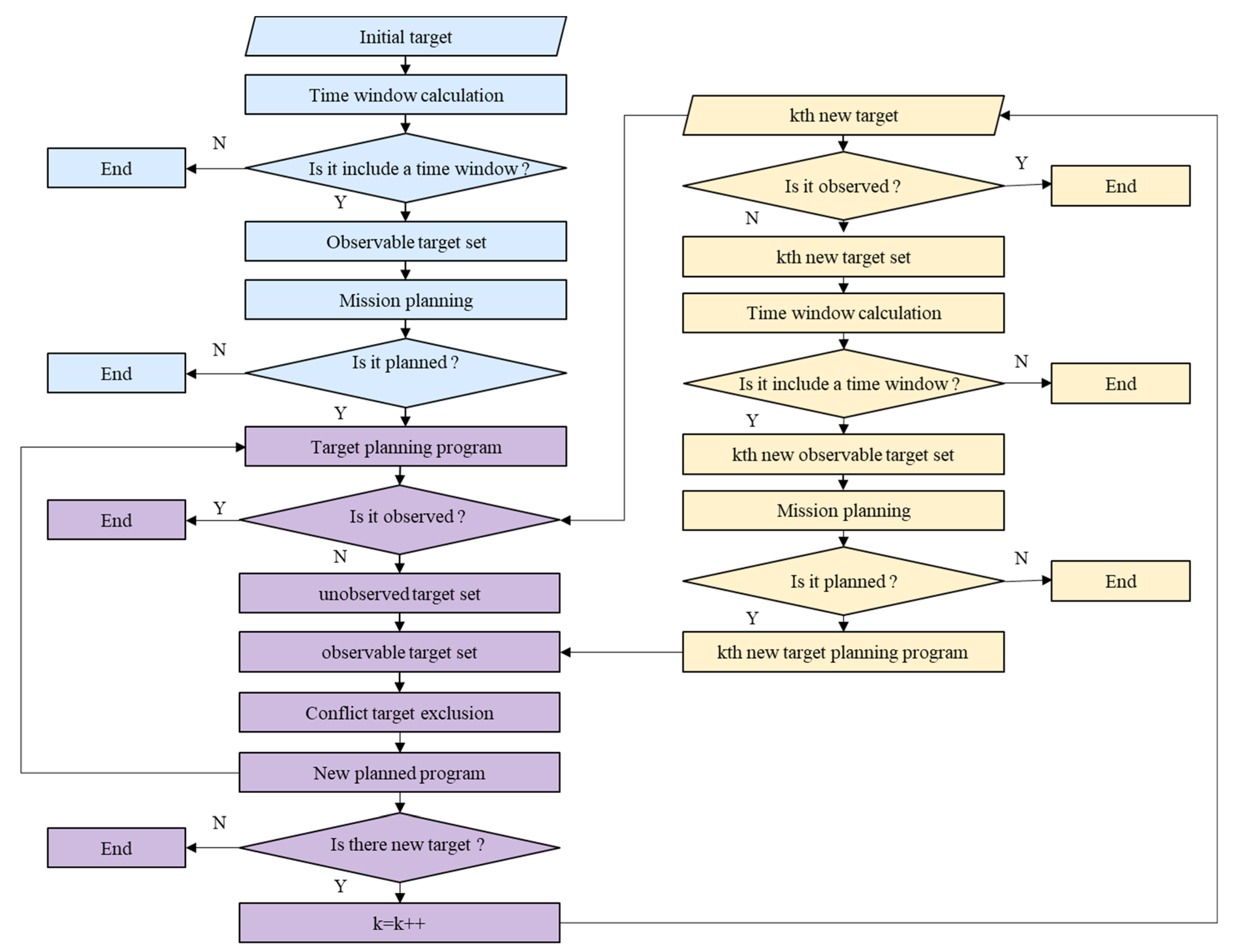
Figure 7. Dynamic task planning algorithm for multi-satellite cooperative observation.
Remotesensing 16 00657 g007
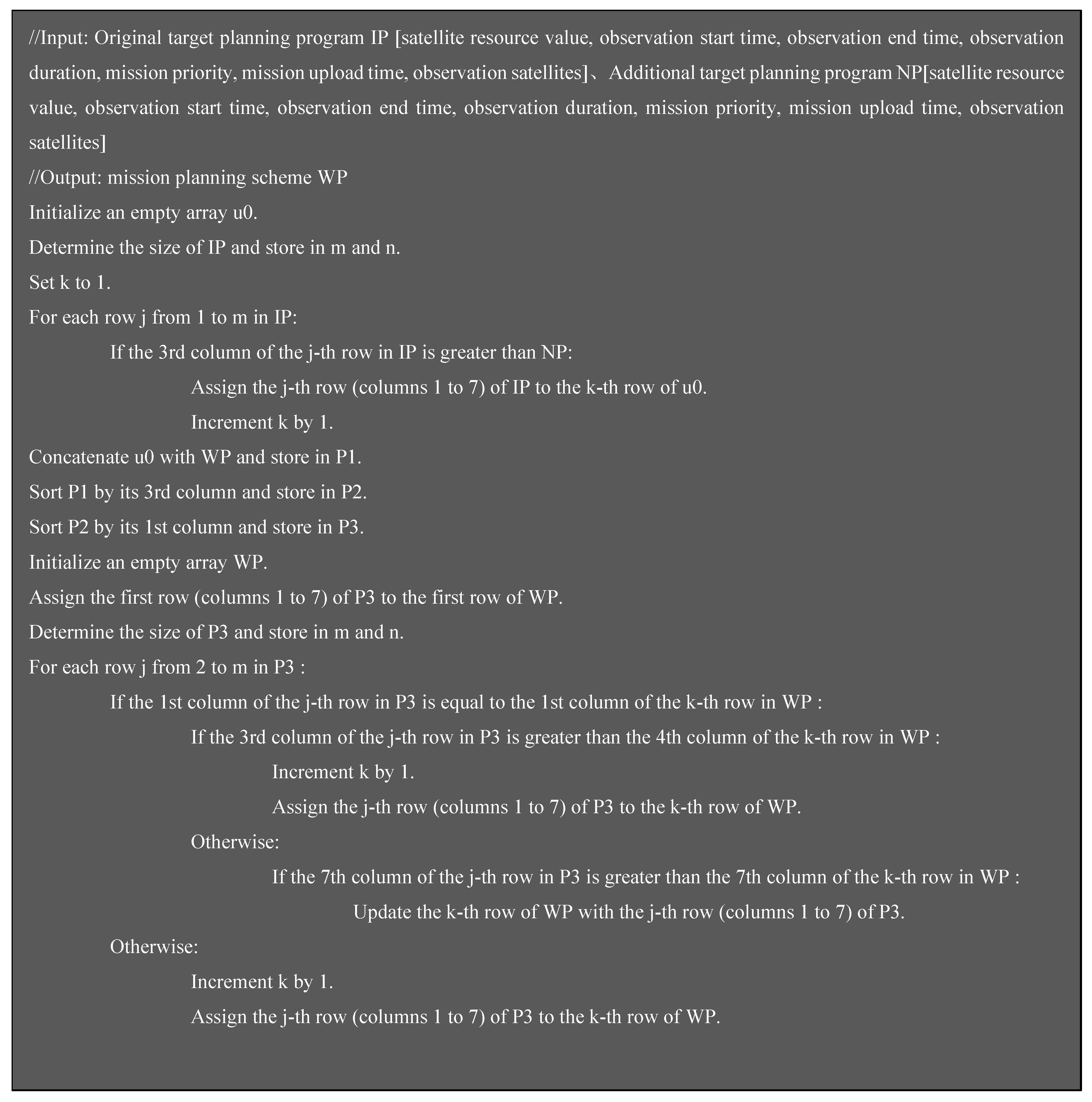
The pseudocode for generalized multi-satellite cooperative observation task planning and dynamic adjustment algorithm for new task planning schemes proposed in this paper are shown in Figure 8 and Figure 9.

3. Design of Experiments

This article proposes a dynamic task planning method for multi-source satellite cooperative observation aimed at complex tasks. The core concept involves initially decomposing complex tasks into multiple individual point-target tasks, each of which can be observed by a single satellite in a single pass. Subsequently, using the dynamic task planning method of multi-source satellite cooperative observation, these varied point-targets are dynamically planned in a unified manner, achieving integrated processing for different types of targets. To validate the effectiveness of the proposed method, a series of experimental analyses were conducted.

3.1. Experimental Environment and Data

Regarding satellite resources, this study simulated 10 satellites as the foundational data for the experiments. Considering potential conflicts in task planning, a resource value index based on the spatial resolution of each satellite was assigned, indicative of its resolution quality. A higher resolution (higher numerical value) correlates to a greater satellite resource value. Table 1 displays the relevant attributes of these 10 satellites.
In terms of observation targets, to simulate terrestrial observation tasks, 2000 point targets were randomly generated. To reflect the dynamic nature of the tasks, these point targets were divided into four groups, added at 0:00, 6:00, 12:00, and 18:00 within the same day, simulating the dynamic variations in observation tasks. To explore the impact of the number of observation targets on the planning results, these targets were further categorized into four different quantity types. By comparing the planning results for different quantities of targets, a comprehensive evaluation of the proposed method was conducted.
Based on these principles, the 2000 point targets were evenly divided into four groups, each containing 500 targets. The 500 targets were further subdivided into subgroups of 50, 100, 150, and 200 targets. The distributions of different numbers of observed targets are shown in Figure 10. The yellow targets represent the targets to be uploaded at the moment of 0 o’clock, the blue targets represent the tasks added at the moment of 6 o’clock, the red targets represent the tasks added at the moment of 12 o’clock, and the green targets represent the tasks added at the moment of 18 o’clock. Through dynamic planning experiments for these four different quantities of targets, the proposed method was validated. The number of targets at each time point in each experiment is shown in Table 2.

3.2. Evaluation Indices

To assess the experimental results, five evaluation indices were established, detailed as follows:
(1)
Total number of planned targets
The total number of observation targets included in the planning scheme is referred to as the total number of planned targets (TNPT). The larger the value of the TNPT in the planning scheme is, the better the results.
(2)
Total computational time
The total time required for configuring satellite resources and observation targets is indicated by total computational time (TCT). The smaller the value of the TCT in the planning scheme is, the better the results.
(3)
Sum of task priorities
The aggregate priority of the observation targets included in the planning scheme is denoted by sum of task priorities (STP). The larger the value of the STP in the planning scheme is, the better the results.
(4)
Total satellite resource value
The term refers to the sum of the resource values of observation satellites configured for all targets in the planning program, denoted by total satellite resource value (TSRV). The smaller the value of the TSRV in the planning scheme is, the better the results.
(5)
Comprehensive benefit value
This is a holistic description of the above four evaluation indices, analyzing the overall efficacy of the planning scheme through a normalization process of these indices, denoted by comprehensive benefit value (CBV). The larger the value of the CBV in the planning scheme is, the better the results. The methodology for calculating the comprehensive evaluation value is shown below.
C B V = T N P T M a x T N P T + M i n T C T T C T + S T P M a x S T P + M i n T S R V T S R V 4
where M a x T N T P T refers to the maximum value of the total number of observed targets in the planning scenario obtained by different methods at the same time. M i n T C T refers to the minimum value of the overall computational time required for a planning solution obtained by different methods at the same time. M a x S T P refers to the maximum value of the sum of the observed target task priorities in the planning scenario obtained by different methods at the same time. M i n T S R V refers to the minimum of the satellite resource values of the planning scenarios obtained by different methods at the same time.

3.3. Experiment and Results

3.3.1. Introduction to Different Methods

To analyze and compare the efficacy of the method proposed in this article, we developed various planning methods by altering the objective functions and dynamic planning schemes. The specific meanings and differences of these methods are illustrated in Table 3.
SP-SM (proposed method): Prioritizes the acquisition of high satellite resource values. When new observation targets emerge, a task planning scheme for these new targets is first devised, followed by its amalgamation with the schemes of unobserved targets from the original plan to facilitate dynamic adjustment.
SP-TM: Also prioritizes high satellite resource values. However, upon the addition of new observation targets, these targets are directly merged with unobserved targets from the original plan, followed by task planning for the entire combined set of targets for scheme adjustment.
TP-SM: Focuses on observing more targets. Like SP-SM, SP-TM initially formulates a task planning scheme for new targets, which is then merged with the schemes of unobserved targets from the original plan.
TP-TM: Similar to TP-SM in its principle of observing more targets, but the treatment of new targets is akin to SP-TM, followed by comprehensive task planning post-merger.

3.3.2. Experimental Results

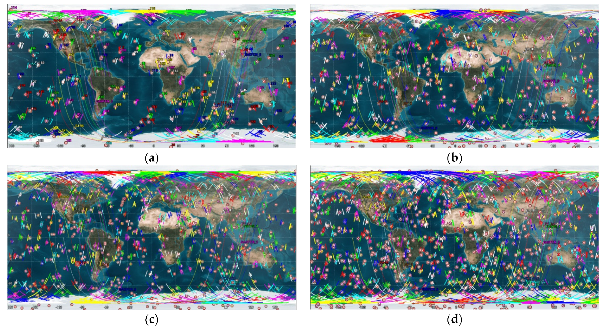
For a fair comparison of the different methods, the study first calculated the time windows for 2000 observational targets based on satellite orbital information. It is used as the basic input condition of different planning methods to provide the same data support for different methods. The results of the time window calculations for 10 satellites for different base numbers of observation targets are shown in Figure 11a–d.
Afterwards, four methods are used to optimize the selection of time windows for different base tasks to obtain the results of the planning scheme at four different time stages. The mission planning results calculated by different methods for different numbers of observation targets at different moments are shown in Table 4.

4. Discussion

4.1. Comparison of Experimental Results

To analyze the impact of dynamic changes and quantities of targets on the planning results, we conducted a comparative analysis of the dimensions of observation time and target quantity.
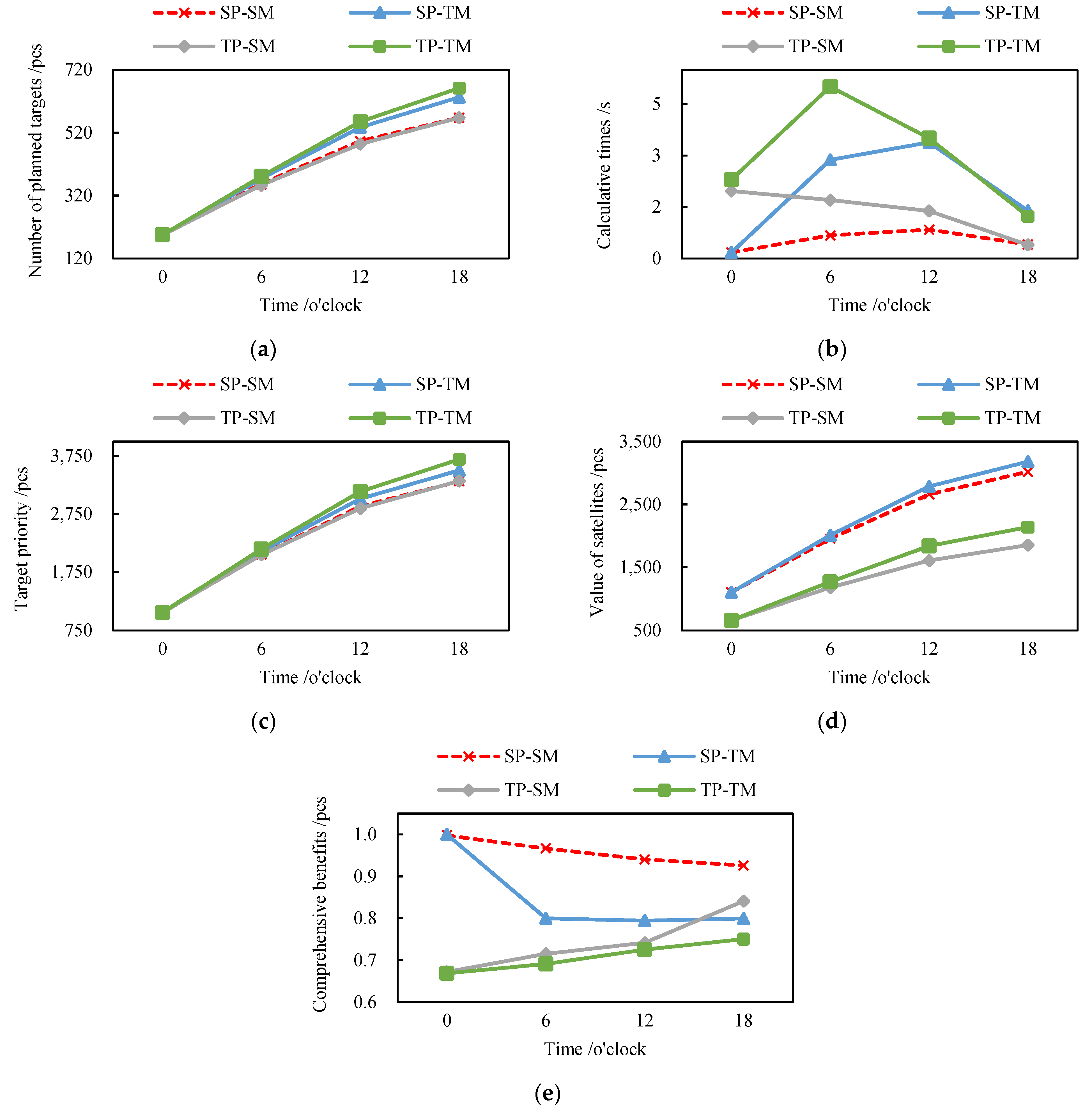
Task planning results at different observation times: Based on 200 targets, task planning was conducted at 0, 6, 12, and 18 h. The total number of planned targets, total computational time, sum of task priorities, total satellite resource value, and comprehensive benefit value for different methods at these times are shown in Figure 12.
Task planning results for different quantities of targets: Results of planning for 50, 100, 150, and 200 targets within a day were recorded. Different methods were compared based on the related indices for varying quantities of observational targets within one day, as shown in Figure 13.

4.2. Analysis of the Experimental Results

(1)
Analysis of task planning results at different observation times
The data in Figure 12a–e reveal that under identical conditions, the method proposed in this study yields moderate performance in terms of the number of planned targets, task priority, and satellite resource values but excels in terms of computational time efficiency and comprehensive benefit value. This superior performance primarily stems from the method’s strategy of merging planning schemes for new tasks, thereby reducing computational complexity. The comprehensive benefit evaluation index indicates that the proposed method achieves higher overall planning target numbers, computational times, task priorities, and satellite resource values.
(2)
Analysis of task planning results for different numbers of targets
Observations from Figure 13a–e indicate that under similar conditions, the method presented in this study performs better in terms of total computational time and comprehensive benefit value. Overall, these findings align with the conclusions drawn at each individual time point. In terms of the overall comprehensive benefit for varying quantities of planned targets, the proposed method significantly outperforms the other three methods, demonstrating a distinct advantage.

4.3. Discussion

In response to the high complexity of resource configuration in complex scenarios, the challenges in unified optimization scheduling for various types of targets, and the shortcomings of static task planning methods in adjusting real-time, dynamically updated user target observation plans, we propose a novel method. This method comprises two main components: task processing and resource allocation. During the task processing stage, we analyze complex scenarios and categorize tasks into four observation modes, for which we design corresponding methods for multi-satellite cooperative observation. In the resource allocation phase, we develop a multi-satellite cooperative observation task planning model that optimizes planning issues through multiple constraints and includes a specially designed algorithm for real-time adjustment of plans, prioritizing urgent targets. The advantage of this method is its ability to achieve unified planning for different types of targets through the decomposition of complex scenarios and to effectuate efficient resource allocation through dynamic optimization scheduling. Its versatility renders it applicable for both the decomposition of complex scenarios and the dynamic scheduling of conventional point targets.
With the advancement of remote sensing satellite technology, there is an increasing need for real-time dynamic task planning to satisfy the demand for high-timeliness remote sensing information services. The multi-satellite cooperative observation dynamic task planning method proposed in this paper provides essential technical support for rapid data acquisition in future efficient remote sensing information services.

5. Conclusions

Aiming at overcoming the complexity of resource allocation in complex scenarios and the difficulty of unified and optimized scheduling of different types of targets, this paper proposes a dynamic mission planning method for multi-source satellite cooperative observation in complex scenarios in terms of two aspects: mission processing and resource allocation. In the task processing stage, we categorize the complex tasks into four observation modes and decompose the tasks of different types of complex scenarios into multiple point targets that can be observed by a single satellite in a single transit by constructing preprocessing models for different observation modes to reduce the complexity of the problem. In terms of resource scheduling, we designed a generalized multi-satellite cooperative observation mission planning method and a dynamic adjustment method for the new mission planning scheme for the decomposed point targets. These methods can realize dynamic and optimized scheduling of different types of point targets and achieve comprehensive optimization of the number of observation targets, computation time, task priority, and satellite resource value. The method proposed in this paper can be used to effectively address various kinds of complex scenarios, optimize the allocation of satellite and land resources, and provide technical support for intelligent observation of remote sensing satellites through the decomposition of observation modes and multi-satellite collaborative mission planning.

Author Contributions

Writing—original draft, Q.W.; Writing—review & editing, J.P. and M.W. All authors have read and agreed to the published version of the manuscript.

Funding

This work was supported by the National Key Research and Development Program of China [grant number 2022YFB3902804] and the Natural Science Foundation of Hubei Province of China [grant number 2020CFA001].

Data Availability Statement

Data are contained within the article.

Conflicts of Interest

The authors declare no conflicts of interest.

References

  1. Yang, F.; Liu, S.Y.; Zhao, J.; Zheng, Q.B. Technology Prospective of Intelligent Remote Sensing Satellite. Spacecr. Eng. 2017, 26, 74–81. [Google Scholar]
  2. Wang, M.; Yang, F. Intelligent remote sensing satellite and remote sensing image realtime intelligent service. Acta Geod. Cart. Sin. 2019, 48, 1586–1594. [Google Scholar]
  3. Marinelli, F.; Nocella, S.; Rossi, F.; Smriglio, S. A Lagrangian heuristic for satellite range scheduling with resource constraints. Comput. Oper. Res. 2011, 38, 1572–1583. [Google Scholar] [CrossRef]
  4. Barkaoui, M.; Berger, J. A new hybrid genetic algorithm for the collection scheduling problem for a satellite constellation. J. Oper. Res. Soc. 2020, 71, 1390–1410. [Google Scholar] [CrossRef]
  5. Wang, H.J.; Yang, Z.; Zhou, W.G.; Li, D.L. Online scheduling of image satellites based on neural networks and deep reinforcement learning. Chin. J. Aeronaut. 2019, 32, 1011–1019. [Google Scholar] [CrossRef]
  6. Beaumet, G.; Verfaillie, G.; Charmeau, M.C. Feasibility of autonomous decision making on board an agile earth-observing satellite. Comput. Intell. 2011, 27, 123–139. [Google Scholar] [CrossRef]
  7. Wu, K.; Zhang, D.X.; Chen, Z.H.; Chen, J.L.; Shao, X.W. Multi-type multi-objective imaging scheduling method based on improved NSGA-III for satellite formation system. Adv. Space Res. 2019, 63, 2551–2565. [Google Scholar] [CrossRef]
  8. Zhang, K.; Sun, Y.; Xia, L.; Zhu, Z.; Wang, J. A method of network satellite on-orbit distributed collaborative mission scheduling. Harbin Gongcheng Daxue Xuebao J. Harbin Eng. Univ. 2019, 40, 393–399. [Google Scholar]
  9. Zhu, W.M.; Hu, X.X.; Xia, W.; Sun, H.Q. A three-phase solution method for the scheduling problem of using earth observation satellites to observe polygon requests. Comput. Ind. Eng. 2019, 130, 97–107. [Google Scholar] [CrossRef]
  10. Zhu, W.M.; Hu, X.X.; Xia, W.; Jin, P. A two-phase genetic annealing method for integrated Earth observation satellite scheduling problems. Soft Comput. 2019, 23, 181–196. [Google Scholar]
  11. Cho, D.H.; Kim, J.H.; Choi, H.L.; Ahn, J. Optimization-Based Scheduling Method for Agile Earth-Observing Satellite Constellation. J. Aerosp. Inf. Syst. 2018, 15, 611–626. [Google Scholar] [CrossRef]
  12. Huang, W.Q.; Wang, H.; Yi, D.B.; Wang, S.; Zhang, B.; Cui, J.W. A Multiple Agile Satellite Staring Observation Mission Planning Method for Dense Regions. Remote Sens. 2023, 15, 5317. [Google Scholar] [CrossRef]
  13. Zhao, Z.G.; Hu, C.; Wang, K.; Zhang, Y.X.; Xu, Z.Y.; Ding, X. An Earth Observation Task Representation Model Supporting Dynamic Demand for Flood Disaster Monitoring and Management. Remote Sens. 2023, 15, 2193. [Google Scholar] [CrossRef]
  14. Chen, Y.X.; Shen, X.; Zhang, G.; Lu, Z.Z. Large-Scale Multi-Objective Imaging Satellite Task Planning Algorithm for Vast Area Mapping. Remote Sens. 2023, 15, 4178. [Google Scholar] [CrossRef]
  15. Wu, G.; Ma, M.; Wang, H.; Qiu, D. Multi-satellite observation scheduling based on task clustering. Acta Aeronaut. Astronaut. Sin. 2011, 32, 1275–1282. [Google Scholar]
Figure 1. Architecture for dynamic task planning in multi-source satellite cooperative observation targeting complex tasks.
Remotesensing 16 00657 g001
Figure 2. Multi-satellite cooperative observation diagram.
Remotesensing 16 00657 g002
Figure 3. Task decomposition solution for the multi-source remote sensing satellite cooperative observation mode.
Remotesensing 16 00657 g003
Figure 4. Task decomposition solution for the regional stitching cooperative observation mode.
Remotesensing 16 00657 g004
Figure 5. Task decomposition solution for the moving target tracking cooperative observation mode.
Remotesensing 16 00657 g005
Figure 6. Task decomposition solution for the moving target tracking cooperative observation mode.
Remotesensing 16 00657 g006
Figure 8. The pseudocode for generalized multi-satellite cooperative observation task planning.
Remotesensing 16 00657 g008
Figure 9. The pseudocode for the dynamic adjustment algorithm for new task planning schemes.
Remotesensing 16 00657 g009
Figure 10. Distribution of observation targets. (a) Distribution of 200 targets. (b) Distribution of 400 targets. (c) Distribution of 600 targets. (d) Distribution of 800 targets.
Remotesensing 16 00657 g010aRemotesensing 16 00657 g010b
Figure 11. Time windows of different observation targets. (a) Time windows of 200 targets. (b) Time windows of 400 targets. (c) Time windows of 600 targets. (d) Time windows of 800 targets.
Remotesensing 16 00657 g011
Figure 12. Planning results of different methods at different times. (a) Number of planning targets. (b) Calculation times. (c) Task priority. (d) Value of satellites. (e) Comprehensive benefits.
Remotesensing 16 00657 g012
Figure 13. Overall planning results for different methods in 1 day. (a) Number of planning targets. (b) Calculation times. (c) Task priority. (d) Value of satellites. (e) Comprehensive benefits.
Remotesensing 16 00657 g013
Table 1. Satellite resource attributes.
NumberNameSpatial ResolutionResolution LevelOrbital Altitude (km)Revisit Period
(Day)
Width (km)Satellite Resource Value
1GAOFEN 21/4meter scale6315451
2ZY 1-02C5/10meter scale7803 603
3ZY 36meter scale5065 515
4ZY 3-25.8meter scale5053514
5SJ-9A2.5/10meter scale6454302
6GAOFEN 116Ten-meter scale64528006
7HJ-1A30Ten-meter scale6494 3608
8HJ-1B30Ten-meter scale6494 3609
9GAOFEN 616Ten-meter scale644.528007
10CBERS 473Ten-meter scale778386610
Table 2. Number of targets added at each point in time for different target number benchmarks.
Experimental Target Number BenchmarksNumber of New Targets at 0 O’clockNumber of New Targets at 6 O’clockNumber of New Targets at 12 O’clockNumber of New Targets at 18 O’clock
5050505050
100100100100100
150150150150150
200200200200200
Table 3. Main contents of the different methods.
MethodAbbreviationDescription
Satellite Priority-Scheme Merging SP-SMOn the premise of maximizing the acquisition of high-resolution data, this approach involves the amalgamation of planning schemes for newly added objectives with those unobserved targets in the original planning scheme, thereby formulating a novel planning scheme.
Satellite Priority-Tasks MergingSP-TMBased on the premise of maximizing the acquisition of high-resolution data, this method entails the amalgamation of newly added objectives with unobserved targets from the original planning scheme. This integrated approach facilitates the collective planning of tasks, culminating in the formulation of a revised planning scheme.
Task-Priority-Scheme MergingTP-SMFocused on the objective of observing as many targets as possible, this method involves the integration of planning schemes for newly added targets with those of unobserved targets in the original plan. This process results in the formation of a new, comprehensive planning scheme.
Task-Priority-Tasks MergingTP-TMBased on the objective of maximizing the number of observed targets, this approach involves the amalgamation of newly added targets with those unobserved in the original planning scheme. By collectively planning these tasks, a new and comprehensive planning scheme is developed.
Table 4. Results of different methods.
MethodTarget NumberPlanning Quantity at 0Calculated Elapsed
time at 0/s
Number of Targets Observed at 6Planning Quantity at 6Calculated Elapsed
Time at 6/s
Number of Targets Observed at 12Planning Quantity at 12Calculated Elapsed time at 12/sNumber of Targets Observed at 18Planning Quantity at 18Calculated Elapsed time at 18/sTotal Number of Targets ObservedTotal Time of CalculateTotal Task PriorityTotal Satellite Resource Value
SP-SM50490.0186 14820.065229960.0795 51760.0584 1700.2218979864
100970.0534 181700.2234611860.24741001360.1472 3150.671317151618
1501480.1072532200.3554792580.4785 1411670.2222 4401.163324292255
2001950.1743 553020.6705 1053330.84341802280.40645682.094533143020
SP-TM50490.0185 14830.1631 29980.1569 52770.0944 1720.4328985872
100970.0523181760.9918 651960.77291041430.26103302.078017771665
1501480.1055532301.3756 802821.77921551910.7685 4794.028725672374
2001950.1727553192.8737 1113713.38541962711.3883 6337.820135043182
TP-SM50490.1247 30670.1180 46650.0959 43520.06591710.4045988557
100970.4181 381400.4648 951260.2803 86890.1246 3081.287616991038
1501481.0722871831.0532 1131970.7218 1431120.22254553.069725021520
2001951.96601072461.7009 1552221.3846 1551510.3961 5685.447633201853
TP-TM50490.1220 30680.2176 46670.1545 45560.1084 1770.60251014567
100970.3832 381561.6669 1091340.627693970.2535 3372.931118141129
1501481.1897 871992.0059 1262131.7851 1561330.66265025.643326991658
2001952.29731072745.0093 1742743.50681971841.2316 66212.04536942139
Disclaimer/Publisher’s Note: The statements, opinions and data contained in all publications are solely those of the individual author(s) and contributor(s) and not of MDPI and/or the editor(s). MDPI and/or the editor(s) disclaim responsibility for any injury to people or property resulting from any ideas, methods, instructions or products referred to in the content.