Coastal Storm-Induced Sinkholes: Insights from Unmanned Aerial Vehicle Monitoring
Abstract
1. Introduction
| Location | Date | Dimension | Causes | References |
|---|---|---|---|---|
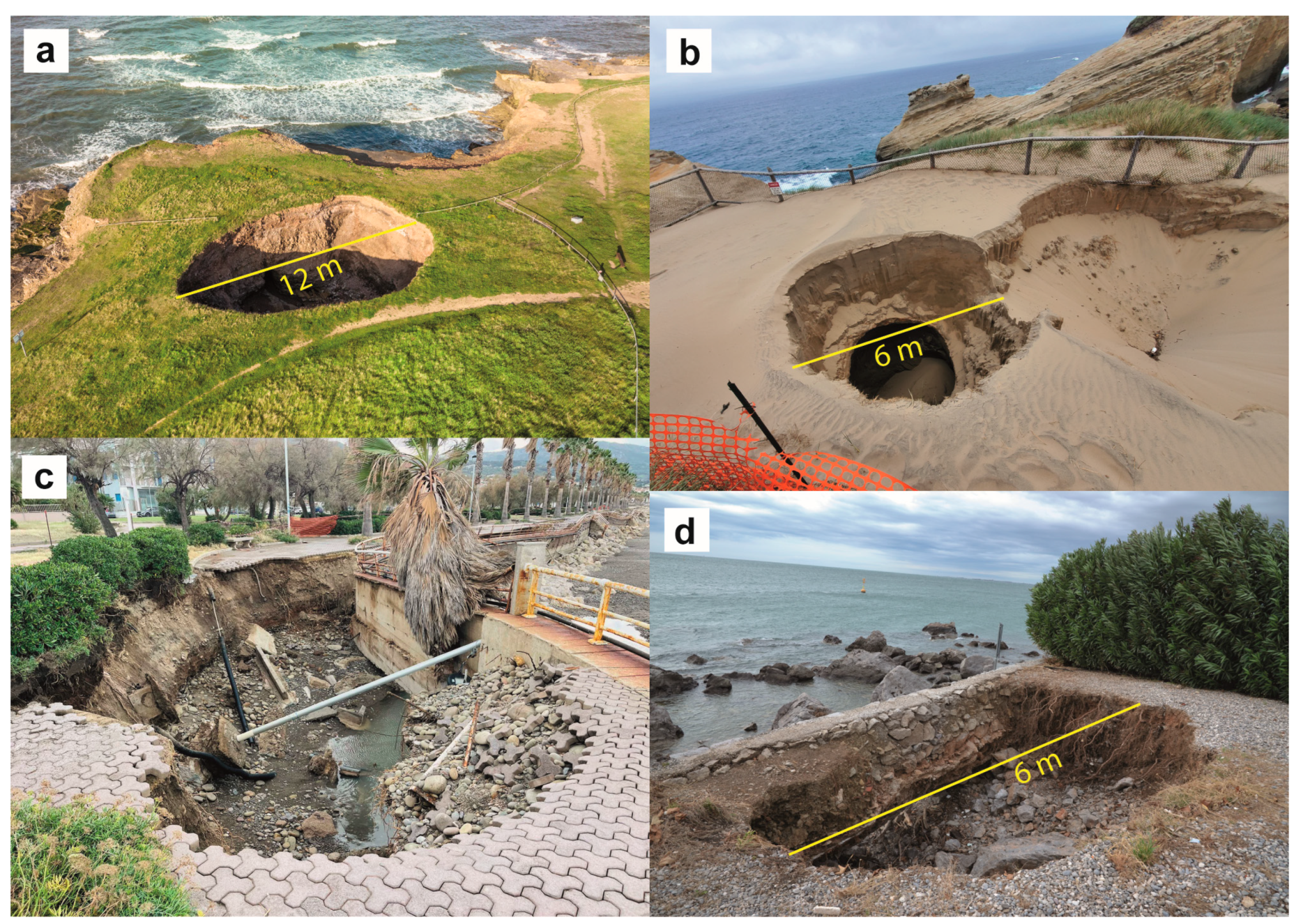
| Scotland | 4 February 2021 | Diameter: 3 m | storm | [41] |
| Scotland | 30 October 2023 | Diameter: 5 m | storm | [42] |
| England | 7 October 2019 | Axis: 2.4 × 6 m Depth: 2.4 m | very heavy rainfall combined with the highest tide of the year | [43] |
| England | 10 January 2022 | Diameter: 12 m | coastal erosion | [44] |
| Australia | 10 June 2021 | ongoing coastal erosion | [45] | |
| Oregon (USA) | 22 January 2023 | Diameter: 6 m Depth: 4.5 m | coastal erosion | [46] |
| Oregon (USA) | 8 May 2023 | Diameter: 3 m | coastal erosion | [47] |
| Italy (Otranto) | progressive erosion by sea wave action | [28] | ||
| Italy (Sicily) | 11 December 2021 | coastal erosion | [48] | |
| Italy (Sicily) | 28 November 2023 | floods | [49] | |
| Italy (Naples) | November 2023 | persistent rainfall and high tide | [50] |
2. Study Area
3. The Extreme Storm Events
4. Materials and Methods
4.1. Wave Modelling
4.2. Orthomosaics and DEMs Creation and Point Cloud Comparison
4.2.1. UAV Survey
4.2.2. GNSS Survey
4.2.3. SfM-MVS Photogrammetry
4.3. HR 3D Models Creation
4.3.1. UAV Survey
4.3.2. SfM-MVS Photogrammetry
5. Results
5.1. Wave Modelling
5.2. Observations on Orthomosaics and DEMs
5.3. HR 3D Models
5.4. Point Clouds Comparison
6. Discussion
6.1. Wave Modelling
6.2. Coastal Sinkhole Formation
6.3. Protective Role of Boulders
7. Conclusions
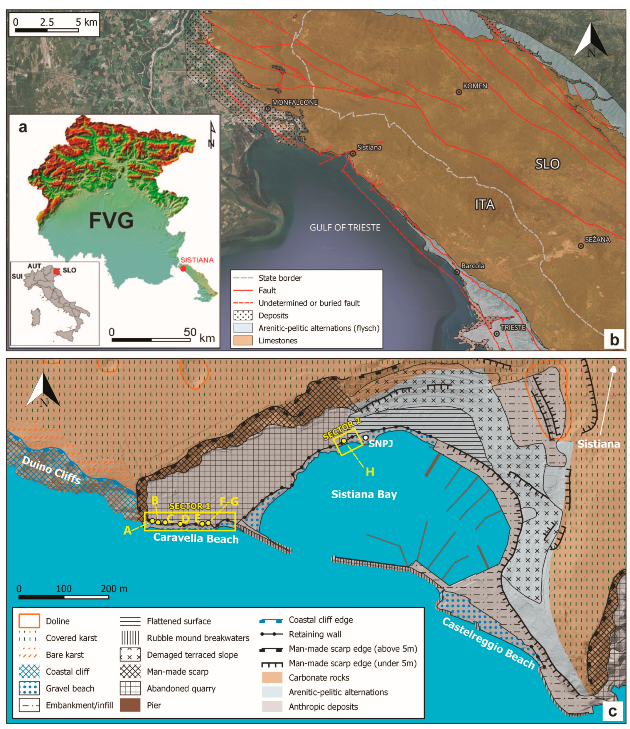
- Preliminary removal of finer material from the beaches;
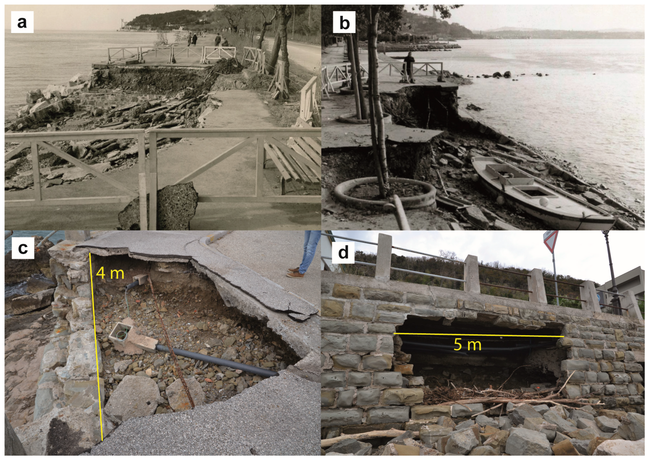
- Under-excavation of the retaining stone walls, causing sagging of the landward embankment behind the retaining wall;
- Subsequent collapse of the materials, including the destruction of the retaining wall in the most representative case of sinkhole H.
- Fast and precise damage assessment, as UAVs allow for rapid HR morphometric analysis and assessment of damage, which can be crucial for timely and effective response and restoration efforts;
- Monitoring over time, as repeated UAV surveys allow for the tracking of tem-poral changes, facilitating long-term observation of coastal dynamics as well as the assessment of catastrophic events.
Author Contributions
Funding
Data Availability Statement
Acknowledgments
Conflicts of Interest
References
- MedECC. Climate and Environmental Change in the Mediterranean Basin–Current Situation and Risks for the Future. In First Mediterranean Assessment Report 2020; Cramer, W., Guiot, J., Marini, K., Eds.; Union for the Mediterranean, Plan Bleu, UNEP/MAP: Marseille, France, 2020; p. 632. ISBN 978-2-9577416-0-1. [Google Scholar]
- Cramer, W.; Guiot, J.; Fader, M.; Garrabou, J.; Gattuso, J.P.; Iglesias, A.; Lange, M.A.; Lionello, P.; Llasat, M.C.; Paz, S.; et al. Climate change and interconnected risks to sustainable development in the Mediterranean. Nat. Clim. Change 2018, 8, 972–980. [Google Scholar] [CrossRef]
- Lionello, P.; Scarascia, L. The relation of climate extremes with global warming in the Mediterranean region and its north versus south contrast. Reg. Environ. Change 2020, 20, 31. [Google Scholar] [CrossRef]
- IPCC. Climate Change 2022: Impacts, Adaptation, and Vulnerability. In Contribution of Working Group II to the Sixth Assessment Report of the Intergovernmental Panel on Climate Change; Pörtner, H.-O., Roberts, D.C., Tignor, M., Poloczanska, E.S., Mintenbeck, K., Alegría, A., Craig, M., Langsdorf, S., Löschke, S., Möller, V., et al., Eds.; Cambridge University Press: Cambridge, UK; New York, NY, USA, 2022; p. 3056. [Google Scholar] [CrossRef]
- Tuel, A.; Eltahir, E.A.B. Why is the mediterranean a climate change hotspot? J. Clim. 2020, 33, 5829–5843. [Google Scholar] [CrossRef]
- Giorgi, F. Climate changes hot-spots. Geophys. Res. Lett. 2006, 33, L08707. [Google Scholar] [CrossRef]
- Giorgi, F.; Lionello, P. Climate change projections for the Mediterranean region. Glob. Planet Change 2008, 63, 90–104. [Google Scholar] [CrossRef]
- Xie, W.; Tang, B.; Meng, Q. The Impact of Sea-Level Rise on Urban Properties in Tampa Due to Climate Change. Water 2022, 14, 13. [Google Scholar] [CrossRef]
- IPCC. Climate Change 2021: The Physical Science Basis. Contribution of Working Group I to the Sixth Assessment Report of the Intergovernmental Panel on Climate Change; Masson-Delmotte, V., Zhai, A.P., Pirani, S.L., Connors, C., Péan, S., Berger, N., Caud, Y., Chen, L., Goldfarb, M.I., Gomis, M., et al., Eds.; Cambridge University Press: Cambridge, UK; New York, NY, USA, 2021; p. 2391. [Google Scholar] [CrossRef]
- Neumann, B.; Vafeidis, A.T.; Zimmermann, J.; Nicholls, R. Future coastal population growth and exposure to sea-level rise and coastal flooding—A global assessment. PLoS ONE 2015, 10, e0118571. [Google Scholar] [CrossRef]
- Ranasinghe, R. Assessing climate change impacts on open sandy coasts: A review. Earth Sci. Rev. 2016, 160, 320–332. [Google Scholar] [CrossRef]
- Nicholls, R.J.; Adger, N.; Hutton, C.W.; Hanson, S.E. Deltas in the Anthropocene; Palgrave Macmillan: Cham, Switzerland, 2020; p. 282. [Google Scholar] [CrossRef]
- Vousdoukas, M.I.; Mentaschi, L.; Voukouvalas, E.; Verlaan, M.; Jevrejeva, S.; Jackson, L.P.; Feyen, L. Global probabilistic projections of extreme sea levels show intensification of coastal flood hazard. Nat. Commun. 2018, 9, 2360. [Google Scholar] [CrossRef] [PubMed]
- Bakkensen, L.A. Mediterranean hurricanes and associated damage estimates. J. Extreme Events 2017, 4, 1750008. [Google Scholar] [CrossRef]
- Portmann, R.; González-Alemán, J.J.; Sprenger, M.; Wernli, H. How an uncertain short-wave perturbation on the North Atlantic wave guide affects the forecast of an intense Mediterranean cyclone (Medicane Zorbas). Weather Clim. Dynam. 2020, 1, 597–615. [Google Scholar] [CrossRef]
- Scicchitano, G.; Scardino, G.; Monaco, C.; Piscitelli, A.; Milella, M.; De Giosa, F.; Mastronuzzi, G. Comparing impact effects of common storms and Medicanes along the coast of southeastern Sicily. Mar. Geol. 2021, 439, 106556. [Google Scholar] [CrossRef]
- Sanuy, M.; Duo, E.; Jäger, W.S.; Ciavola, P.; Jiménez, J.A. Linking source with consequences of coastal storm impacts for climate change and risk reduction scenarios for Mediterranean sandy beaches. NHESS 2018, 18, 1825–1847. [Google Scholar] [CrossRef]
- Lira-Loarca, A.; Cobos, M.; Losada, M.Á.; Baquerizo, A. Storm characterization and simulation for damage evolution models of maritime structures. Coast Eng. 2020, 156, 103620. [Google Scholar] [CrossRef]
- Amores, A.; Marcos, M.; Carrió, D.S.; Gómez-Pujol, L. Coastal impacts of Storm Gloria (January 2020) over the northwestern Mediterranean. NHESS 2020, 20, 1955–1968. [Google Scholar] [CrossRef]
- Cavaleri, L.; Bajo, M.; Barbariol, F.; Bastianini, M.; Benetazzo, A.; Bertotti, L.; Chiggiato, J.; Davolio, S.; Ferrarin, C.; Magnusson, L.; et al. The October 29, 2018 storm in Northern Italy–an exceptional event and its modelling. Prog. Oceanogr. 2019, 178, 102178. [Google Scholar] [CrossRef]
- Jiménez, J.; Sanuy, M.; Ballesteros, C.; Valdemoro, H. The Tordera Delta, a hotspot to storm impacts in the coast northwards of Barcelona (NW Mediterranean). Coast Eng. 2018, 134, 148–158. [Google Scholar] [CrossRef]
- Amarouche, K.; Akpınar, A.; Cakmak, R.E.; Houma, F.; Bachari, N.E.I. Assessment of storm events along the Algiers coast and their potential impacts. Ocean Eng. 2020, 210, 107432. [Google Scholar] [CrossRef]
- Anfuso, G.; Postacchini, M.; Di Luccio, D.; Benassai, G. Coastal sensitivity/vulnerability characterization and adaptation strategies: A review. J. Mar. Sci. Eng. 2021, 9, 72. [Google Scholar] [CrossRef]
- Melet, A.; Meyssignac, B.; Almar, R.; Le Cozannet, G. Under-estimated wave contribution to coastal sea-level rise. Nat. Clim. Change 2018, 8, 234–239. [Google Scholar] [CrossRef]
- McEvoy, S.; Hassnoot, M.; Biesbroek, R. How are European countries planning for sea level rise? Ocean Coast Manag. 2021, 203, 105512. [Google Scholar] [CrossRef]
- Harley, M.D.; Turner, I.L.; Kinsela, M.A.; Middleton, J.H.; Mumford, P.J.; Splinter, K.D.; Phillips, M.S.; Simmons, J.A.; Hanslow, D.J.; Short, A.D. Extreme coastal erosion enhanced by anomalous extratropical storm wave direction. Sci. Rep. 2017, 7, 6033. [Google Scholar] [CrossRef]
- Biolchi, S.; Denamiel, C.; Devoto, S.; Korbar, T.; Macovaz, V.; Scicchitano, G.; Vilibić, I.; Furlani, S. Impact of the October 2018 Storm Vaia on Coastal Boulders in the Northern Adriatic Sea. Water 2019, 11, 2229. [Google Scholar] [CrossRef]
- Parise, M. Sinkholes. In Encyclopedia of Caves, 3rd ed.; William, B., White, D.C., Culver, T.P., Eds.; Academic Press: Cambridge, MA, USA, 2019; pp. 934–942. [Google Scholar] [CrossRef]
- Liso, I.S. Sinkhole occurrence and evolution, and seawater intrusion in a low-coastal setting of Apulia. Ital. J. Eng. Geol. Environ. 2024, 197–204. [Google Scholar] [CrossRef]
- Forth, R.A.; Butcher, D.; Senior, R. Hazard mapping of karst along the coast of the Algarve, Portugal. Eng. Geol. 1999, 52, 67–74. [Google Scholar] [CrossRef]
- Bruno, E.; Calcaterra, D.; Parise, M. Development and morphometry of sinkholes in coastal plains of Apulia, southern Italy. Preliminary sinkhole susceptibility assessment. Eng. Geol. 2008, 99, 198–209. [Google Scholar]
- Delle Rose, M.; Parise, M. Karst subsidence in south-central Apulia Italy. Int. J. Speleol. 2002, 31, 181–199. [Google Scholar] [CrossRef]
- Delle Rose, M.; Parise, M. Slope instability along the Adriatic coast of Salento, southern Italy. In Proceedings of the IX International Symposium on Landslides, Rio de Janeiro, Brasil, 28 June 2004–2 July 2004; Volume 1, pp. 399–404. [Google Scholar]
- Delle Rose, M.; Parise, M. Speleogenesi e geomorfologia del sistema carsico delle Grotte della Poesia nell’ambito dell’evoluzione quaternaria della costa Adriatica Salentina. Atti E Mem. Comm. Grotte “E. Boegan” 2005, 40, 153–173. [Google Scholar]
- Delle Rose, M.; Federico, A.; Parise, M. Sinkhole genesis and evolution in Apulia, and their interrelations with the anthropogenic environment. NHESS 2004, 4, 747–755. [Google Scholar] [CrossRef]
- Parise, M. I sinkholes in Puglia. In I Fenomeni Naturali di Sinkhole Nelle Aree di Pianura Italiana; Nisio, S., Ed.; Memorie descrittive della Carta Geologica d’Italia: Rome, Italy, 2008; Volume 85, pp. 309–334. [Google Scholar]
- Del Prete, S.; Iovine, G.; Parise, M.; Santo, A. Origin and distribution of different types of sinkholes in the plain areas of Southern Italy. Geodin. Acta 2010, 23, 113–127. [Google Scholar] [CrossRef]
- Margiotta, S.; Negri, S.; Parise, M.; Valloni, R. Mapping the susceptibility to sinkholes in coastal areas, based on stratigraphy, geomorphology and geophysics. Nat. Hazards 2012, 62, 657–676. [Google Scholar] [CrossRef]
- Coratza, P.; Galve, J.P.; Soldati, M.; Tonelli, C. Recognition and assessment of sinkholes as geosites: Lessons from the Island of Gozo (Malta). Quaest. Geogr. 2012, 31, 25–35. [Google Scholar] [CrossRef]
- Soldati, M.; Tonelli, C.; Galve, J.P. Geomorphological evolution of palaeosinkhole features in the Maltese archipelago (Mediterranean Sea). GFDQ 2013, 36, 189–198. [Google Scholar] [CrossRef]
- The Scottish Sun. Available online: https://www.thescottishsun.co.uk/news/6634343/sinkhole-fife-coastal-path-west-wemyss-harbour/ (accessed on 23 April 2024).
- Edinburghlive. Available online: https://www.edinburghlive.co.uk/news/edinburgh-news/east-lothian-locals-warned-huge-28012627 (accessed on 23 April 2024).
- Chroniclelive. Available online: https://www.chroniclelive.co.uk/news/north-east-news/what-caused-giant-sinkhole-blyth-17049690 (accessed on 23 April 2024).
- Independent. Available online: https://www.independent.co.uk/tv/climate/huge-sinkhole-appears-at-coastal-beauty-spot-revealing-hidden-underground-beach-b2195003.html (accessed on 23 April 2024).
- Newsweek. Available online: https://www.newsweek.com/coastal-sinkhole-suck-people-ocean-appears-overnight-1599411 (accessed on 23 April 2024).
- The news tribune. Available online: https://www.thenewstribune.com/news/nation-world/national/article271602352.html (accessed on 23 April 2024).
- OPB. Available online: https://www.opb.org/article/2023/05/20/2-sinkholes-have-appeared-on-oregons-north-coast-heres-more-on-why-they-happen/ (accessed on 23 April 2024).
- MeteoWeb. Available online: https://www.meteoweb.eu/2021/12/maltempo-mareggiata-a-marsala-cede-tratto-del-lungomare/1746896/ (accessed on 23 April 2024).
- In Alto Mare–Sant’Agata di Militello. Available online: https://www.facebook.com/inaltomare.santagata/ (accessed on 23 April 2024).
- IlFattoVesuviano. Available online: https://www.ilfattovesuviano.it/2023/11/forti-mareggiate-crolla-la-litoranea-di-torre/#google_vignette (accessed on 23 April 2024).
- Cooper, A.H. The classification, recording, databasing and use of information about building damage caused by subsidence and landslides. QJEGH 2008, 41, 409–424. [Google Scholar] [CrossRef]
- Gutierrez, F. Sinkhole hazards. In Oxford Research Encyclopedia of Natural Hazard Science 2016; Oxford University Press: Oxford, UK, 2016. [Google Scholar] [CrossRef]
- Calligaris, C.; Devoto, S.; Zini, L. Evaporite sinkholes of the Friuli Venezia Giulia region (NE Italy). J. Maps 2017, 13, 406–414. [Google Scholar] [CrossRef]
- Busetti, A.; Calligaris, C.; Forte, E.; Areggi, G.; Mocnik, A.; Zini, L. Non-invasive methodological approach to detect and characterize high-risk sinkholes in urban cover evaporite karst: Integrated reflection seismics, PS-InSAR, leveling, 3D-GPR and ancillary data. A NE Italian case study. Remote Sens. 2020, 12, 3814. [Google Scholar] [CrossRef]
- Parise, M. Sinkholes, subsidence and related mass movements. In Treatise on Geomorphology 5; Shroder, J.J.F., Ed.; Academic Press: Cambridge, MA, USA; Elsevier: Amsterdam, The Netherlands, 2022; pp. 200–220. [Google Scholar] [CrossRef]
- Sevil, J.; Gutiérrez, F. Morphometry and evolution of sinkholes on the western shore of the Dead Sea. Implications for susceptibility assessment. Geomorphology 2023, 434, 108732. [Google Scholar] [CrossRef]
- Gonçalves, J.A.; Henriques, R. UAV photogrammetry for topographic monitoring of coastal areas. ISPRS J. Photogramm. 2015, 104, 101–111. [Google Scholar] [CrossRef]
- Turner, I.L.; Harley, M.D.; Drummond, C.D. UAVs for coastal surveying. Coast Eng. 2016, 114, 19–24. [Google Scholar] [CrossRef]
- Carrivick, J.L.; Smith, M.W.; Quincey, D.J. Structure from Motion in the Geosciences; Collection of New Analytical Methods in Earth Environ Sci; John Wiley & Sons: Chichester, UK, 2016. [Google Scholar] [CrossRef]
- Seong, K.; Leeb, T.; Singhc, V.P. UAV Photogrammetry-based Sea Level Establishment for a Storm Surge Early Warning System in Wolpo-beach, South Korea. KSCE J. Civ. Eng. 2024, 28, 2505–2514. [Google Scholar] [CrossRef]
- Albuquerque, M.; Alves, D.C.L.; Espinoza, J.M.A.; Oliveira, U.R.; Simões, R.S. Determining shoreline response to meteo-oceanographic events using remote sensing and unmanned aerial vehicle (UAV): Case study in southern Brazil. J. Coast Res. 2018, 85, 766–770. [Google Scholar] [CrossRef]
- Brunetta, R.; Duo, E.; Ciavola, P. Evaluating Short-Term Tidal Flat Evolution Through UAV Surveys: A Case Study in the Po Delta (Italy). Remote Sens. 2021, 13, 2322. [Google Scholar] [CrossRef]
- Duo, E.; Trembanis, A.C.; Dohner, S.; Grottoli, E.; Ciavola, P. Local-scale post-event assessments with GPS and UAV-based quick-response surveys: A pilot case from the Emilia–Romagna (Italy) coast. NHESS 2018, 18, 2969–2989. [Google Scholar] [CrossRef]
- Adams, S.M.; Friedlandb, C.J.; Levitanc, M.L. Unmanned Aerial Vehicle Data Acquisition for Damage Assessment in Hurricane Events. In Proceedings of the 8th International Workshop on Remote Sensing for Disaster Management, Tokyo, Japan, 30 September–1 October 2010. [Google Scholar]
- Biolchi, S.; Furlani, S.; Devoto, S.; Scicchitano, G.; Korbar, T.; Vilibić, I.; Šepić, J. The origin and dynamics of coastal boulders in a semi-enclosed shallow basin: A northern Adriatic case study. Mar. Geol. 2019, 411, 62–77. [Google Scholar] [CrossRef]
- Pinton, D.; Canestrelli, A.; Moon, R.; Wilkinson, B. Estimating Ground Elevation in Coastal Dunes from High-Resolution UAV-LIDAR Point Clouds and Photogrammetry. Remote Sens. 2023, 15, 226. [Google Scholar] [CrossRef]
- Casella, E.; Drechsel, J.; Winter, C.; Benninghoff, M.; Rovere, A. Accuracy of sand beach topography surveying by drones and photogrammetry. Geo-Mar. Lett. 2020, 40, 255–268. [Google Scholar] [CrossRef]
- Laporte-Fauret, Q.; Marieu, V.; Castelle, B.; Michalet, R.; Bujan, S.; Rosebery, D. Low-Cost UAV for High-Resolution and Large-Scale Coastal Dune Change Monitoring Using Photogrammetry. J. Mar. Sci. Eng. 2019, 7, 63. [Google Scholar] [CrossRef]
- Mancini, F.; Dubbini, M.; Gattelli, M.; Stecchi, F.; Fabbri, S.; Gabbianelli, G. Using unmanned aerial vehicles (UAV) for high-resolution reconstruction of topography: The structure from motion approach on coastal environments. Remote Sens. 2013, 5, 6880–6898. [Google Scholar] [CrossRef]
- Casagrande, G.; Bezzi, A.; Fracaros, S.; Martinucci, D.; Pillon, S.; Salvador, P.; Sponza, S.; Fontolan, G. Quantifying Transgressive Coastal Changes Using UAVs: Dune Migration, Overwash Recovery, and Barrier Flooding Assessment and Interferences with Human and Natural Assets. J. Mar. Sci. Eng. 2023, 11, 1044. [Google Scholar] [CrossRef]
- Fontolan, G.; Bezzi, A.; Casagrande, G.; Fracaros, S.; Popesso, C.; Spadotto, S.; Favaro, M.; Papa, A. Real-Time Monitoring System and an Early Warning System Implemented. Report D 5.4.3_Part B_ Stream project 2023. Available online: https://programming14-20.italy-croatia.eu/web/stream/docs-and-tools-details?id=2136615&nAcc=5&file=12 (accessed on 23 April 2024).
- Archivio di Stato di Trieste. Available online: https://archiviodistatotrieste.it/documento-del-mese/novembre-2023-mareggiate-a-trieste/ (accessed on 23 April 2024).
- Zini, L.; Calligaris, C.; Cucchi, F. Along the hidden Timavo. GFT&M 2022, 14, 1–69. [Google Scholar] [CrossRef]
- Jurkovšek, B.; Biolchi, S.; Furlani, S.; Kolar-Jurkovšek, T.; Zini, L.; Jež, J.; Tunis, G.; Bavec, M.; Cucchi, F. Geology of the Classical Karst Region (SW Slovenia–NE Italy). J. Maps 2016, 12, 352–362. [Google Scholar] [CrossRef]
- Schmid, S.M.; Bernoulli, D.; Fügenschuh, B.; Matenco, L.; Schefer, S.; Schuster, R.; Tischler, M.; Ustaszewski, K. The Alpine- Carpathian-Dinaridic orogenic system: Correlation and evolution of tectonic units. Swiss J. Geosci. 2008, 101, 139–183. [Google Scholar] [CrossRef]
- van Unen, M.; Matenco, L.; Nader, F.H.; Darnault, R.; Mandic, O.; Demir, V. Kinematics of foreland-vergent crustal accretion: Inferences from the Dinarides evolution. Tectonics 2019, 38, 49–76. [Google Scholar] [CrossRef]
- van Hinsbergen, D.J.; Torsvik, T.H.; Schmid, S.M.; Maţenco, L.C.; Maffione, M.; Vissers, R.L.; Gürer, D.; Spakman, W. Orogenic architecture of the Mediterranean region and kinematic reconstruction of its tectonic evolution since the Triassic. Gondwana Res. 2020, 81, 79–229. [Google Scholar] [CrossRef]
- Korbar, T. Orogenic evolution of the External Dinarides in the NE Adriatic region: A model constrained by tectonostratigraphy of Upper Cretaceous to Paleogene carbonates. Earth-Sci. Rev. 2009, 96, 296–312. [Google Scholar] [CrossRef]
- Balling, P.; Tomljenović, B.; Schmid, S.M.; Ustaszewski, K. Contrasting along-strike deformation styles in the central external Dinarides assessed by balanced cross-sections: Implications for the tectonic evolution of its Paleogene flexural foreland basin system. Global Planet Change 2021, 205, 103587. [Google Scholar] [CrossRef]
- Consorti, L.; Corradetti, A.; Hadi, M.; Franceschi, M.; Sabbatino, M.; Bensi, S.; Bertone, N.; Bonini, L. Biostratigraphic investigations assisted by virtual outcrop modeling: A case study from an Eocene shallow-water carbonate succession (Val Rosandra gorge, Trieste, NE Italy). Ital. J. Geosci. 2024, 143, 60–74. [Google Scholar] [CrossRef]
- Zini, L.; Calligaris, C.; Forte, E.; Turpaud, P. Flood hazard assessment in a polje: The case of Mucille (Classical Karst Region, NE Italy). Environ. Earth Sci. 2023, 82, 293. [Google Scholar] [CrossRef]
- Furlani, S.; Ninfo, A.; Zavagno, E.; Paganini, P.; Zini, L.; Biolchi, S.; Antonioli, F.; Coren, F.; Cucchi, F. Submerged notches in Istria and The Gulf of Trieste: Results from the Geoswim Project. Quat. Int. 2014, 332, 37–47. [Google Scholar] [CrossRef]
- Trobec, A.; Busetti, M.; Zgur, F.; Baradello, L.; Babich, A.; Cova, A.; Gordini, E.; Romeo, R.; Tomini, I.; Poglajen, S.; et al. Thickness of marine Holocene sediment in the Gulf of Trieste (northern Adriatic Sea). Earth Syst. Sci. Data 2018, 10, 1077–1092. [Google Scholar] [CrossRef]
- Bezzi, A.; Casagrande, G.; Fracaros, S.; Martinucci, D.; Pillon, S.; Sponza, S.; Bratus, A.; Fattor, F.; Fontolan, G. Geomorphological changes of a migrating sandbank: Multidecadal analysis as a tool for managing conflicts in coastal use. Water 2021, 13, 3416. [Google Scholar] [CrossRef]
- Brambati, A. Modificazioni costiere nell’arco lagunare dell’Adriatico Settentrionale. Antich. Altoadriatiche 1985, 27, 13–47. [Google Scholar]
- Marocco, R. Lineamenti geomorfologici della costa e dei fondali del Golfo di Trieste e considerazioni sulla loro evoluzione tardo-quaternaria. Int. J. Speleol. 1989, 18, 87–110. [Google Scholar] [CrossRef]
- Gordini, E.; Caressa, S.; Marocco, R. Nuova carta morfo-sedimentologica del Golfo di Trieste (Da Punta Tagliamento alla foce dell’Isonzo). Gortania. Atti. Mus. Friul. Stor. Nat. 2003, 25, 5–29. [Google Scholar]
- European Marine Observation and Data Network (EMODnet). Available online: http://www.emodnet-bathymetry.eu (accessed on 10 June 2024).
- Trobec, A.; Busetti, M. Models of the bathymetry, of the base and of the thickness of Holocene marine sediment in the Gulf of Trieste (Northern Adriatic Sea). OGS SNAP System. 2017. Available online: https://snap.ogs.it/cache/doi/6ad9b1e6-c977-cec9-8a2d-db10c7f90adc/58074ea270863f0a32214fab4f43d42c.jsp (accessed on 10 June 2024).
- Petti, M.; Pascolo, S.; Bosa, S.; Bezzi, A.; Fontolan, G. Tidal Flats Morphodynamics: A new Conceptual Model to Predict Their Evolution over a Medium-Long Period. Water 2019, 11, 1176. [Google Scholar] [CrossRef]
- Dorigo, L. La Laguna di Grado e le Sue Foci. Ricerche e Rilievi Idrografici. Magistr. Alle Acque-Ufficio Idrografico 1965, 155, 1–231. [Google Scholar]
- RAFVG. Piano Regolatore Portuale del Porto di Monfalcone, Variante Localizzata. Studio Meteomarino. 2019. Available online: https://www.regione.fvg.it/rafvg/export/sites/default/RAFVG/ambiente-territorio/pianificazione-gestione-territorio/FOGLIA9/allegati/Allegato_33_alla_Delibera_2066-2019.pdf (accessed on 23 April 2024).
- Triestenews. Available online: https://www.triesteallnews.it/2023/11/uno-spettacolo-di-desolazione-la-mareggiata-che-travolse-trieste-nel-1911/ (accessed on 23 April 2024).
- Il Piccolo. Available online: https://ilpiccolo.gelocal.it/trieste/cronaca/2023/11/13/news/mareggiata_trieste_danni_quattro_milioni-13856672/ (accessed on 25 September 2024).
- Amoudry, L.O.; Souza, A.J. Deterministic coastal morphological and sediment transport modeling: A review and discussion. Rev. Geophys. 2011, 49. [Google Scholar] [CrossRef]
- Baldoni, A.; Melito, L.; Marini, F.; Galassi, G.; Giacomin, P.; Filomena, G.; Barbizzi, N.; Lorenzoni, C.; Brocchini, M. Modeling coastal inundation for adaptation to climate change at local scale: The case of Marche Region (central Italy). Front. Clim. 2024, 6, 1334625. [Google Scholar] [CrossRef]
- Chaumillon, E.; Bertin, X.; Fortunato, A.B.; Bajo, M.; Schneider, J.L.; Dezileau, L.; Walsh, J.P.; Michelot, A.; Chauveau, E.; Créach, A.; et al. Storm-induced marine flooding: Lessons from a multidisciplinary approach. Earth-Sci. Rev. 2017, 165, 151–184. [Google Scholar] [CrossRef]
- Chen, Z.; Luo, F.; Zhou, G.; Zhu, F.; Wu, H.; Li, R.; Zhang, C. Hydrodynamic modeling study of nature-based hybrid coastal defense strategy applied in salt marsh restoration. Estuar. Coast Shelf Sci. 2024, 298, 108666. [Google Scholar] [CrossRef]
- Yaiche Temam, I.; Bouhmadouche, M.; Hemdane, Y.; Kessali, N.; Amiri, H. Analysis of the hydrosedimentary circulation in the mouth of dominated wave environment using grain size analysis, wave/current modeling and image processing case of the principal Rivers in Zemmouri bay. MESE 2024, 10, 4279–4294. [Google Scholar] [CrossRef]
- Verhoeven, G. Taking computer vision Aloft-archaeological three-dimensional reconstructions from aerial photographs with photoscan. Archaeol. Prospect 2011, 18, 67–73. [Google Scholar] [CrossRef]
- Ullman, S. The interpretation of structure from motion. Proc. R Soc. Lond. B 1979, 203, 405–426. [Google Scholar] [CrossRef] [PubMed]
- Grün, A.; Remondino, F.; Zhang, L. Photogrammetric reconstruction of the Great Buddha of Bamiyan, Afghanistan. Photogramm. Rec. 2004, 19, 177–199. [Google Scholar] [CrossRef]
- Szeliski, R. Image processing. In Computer Vision: Algorithms and Applications; Springer: Cham, Switzerland, 2022; pp. 85–151. [Google Scholar] [CrossRef]
- Vaccher, V.; Hastewell, L.; Devoto, S.; Corradetti, A.; Mantovani, M.; Korbar, T.; Furlani, S. The application of UAV-derived SfM-MVS photogrammetry for the investigation of storm wave boulder deposits on a small rocky island in the semi-enclosed Northern Adriatic Sea. Geomat. Nat. Haz. Risk 2024, 15, 2295817. [Google Scholar] [CrossRef]
- Seitz, S.M.; Curless, B.; Diebel, J.; Scharstein, D.; Szeliski, R. A comparison and evaluation of multi-view stereo reconstruction algorithms. In Proceedings of the 2006 IEEE Computer Society Conference on Computer Vision and Pattern Recognition—Volume 1 (CVPR’06), New York, NY, USA, 5 June 2006; pp. 519–528. [Google Scholar] [CrossRef]
- Corradetti, A.; Seers, T.; Mercuri, M.; Calligaris, C.; Busetti, A.; Zini, L. Benchmarking Different SfM-MVS Photogrammetric and iOS LiDAR Acquisition Methods for the Digital Preservation of a Short-Lived Excavation: A Case Study from an Area of Sinkhole Related Subsidence. Remote Sens. 2022, 14, 5187. [Google Scholar] [CrossRef]
- CloudCompare: 3D Point Cloud and Mesh Processing Software Open Source Project. Available online: https://www.danielgm.net/cc/ (accessed on 10 June 2024).
- Kim, H.; Kim, H.; Hyun, C.-U.; Park, H.-D.; Cha, J. Image Mapping Accuracy Evaluation Using UAV with Standalone, Differential (RTK), and PPP GNSS Positioning Techniques in an Abandoned Mine Site. Sensors 2023, 23, 5858. [Google Scholar] [CrossRef]
- Tavani, S.; Pignalosa, A.; Corradetti, A.; Mercuri, M.; Smeraglia, L.; Riccardi, U.; Seers, T.; Pavlis, T.; Billi, A. Photogrammetric 3D Model via Smartphone GNSS Sensor: Workflow, Error Estimate, and Best Practices. Remote Sens. 2020, 12, 3616. [Google Scholar] [CrossRef]
- Corradetti, A.; Seers, T.D.; Billi, A.; Tavani, S. Virtual Outcrops in a Pocket: The Smartphone as a Fully Equipped Photogrammetric Data Acquisition Tool. GSA Today 2021, 31, 4–9. [Google Scholar] [CrossRef]

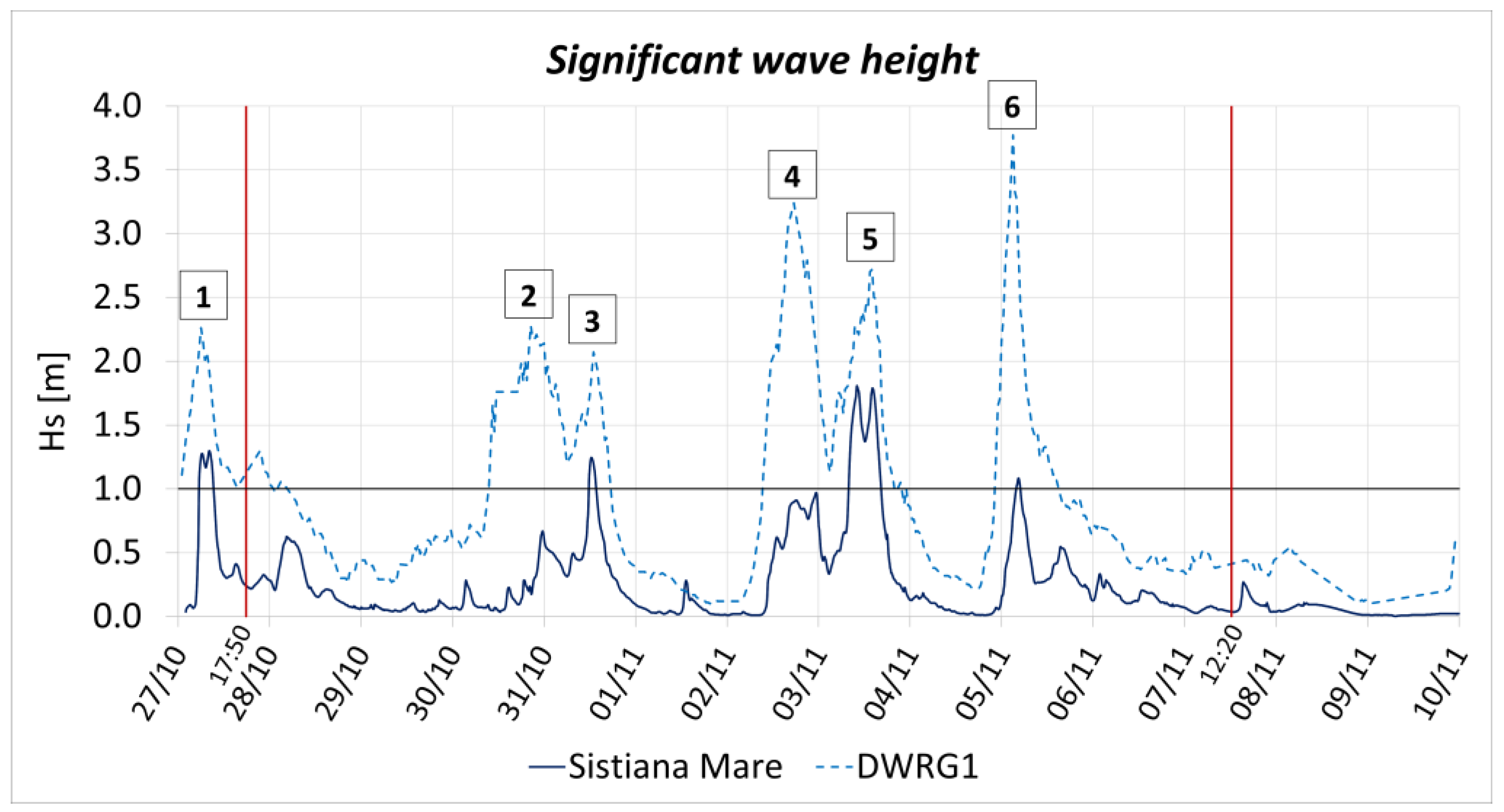
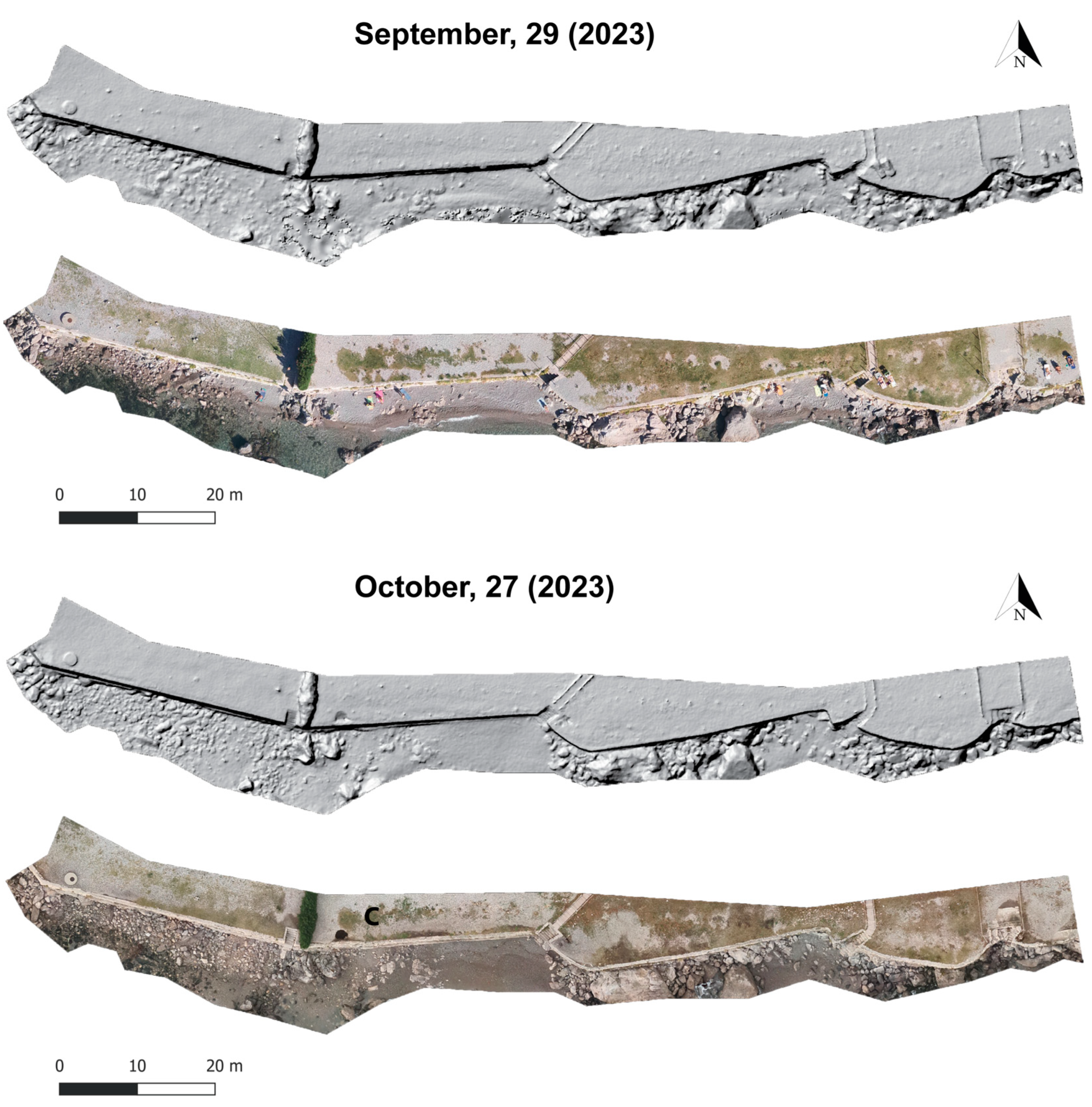
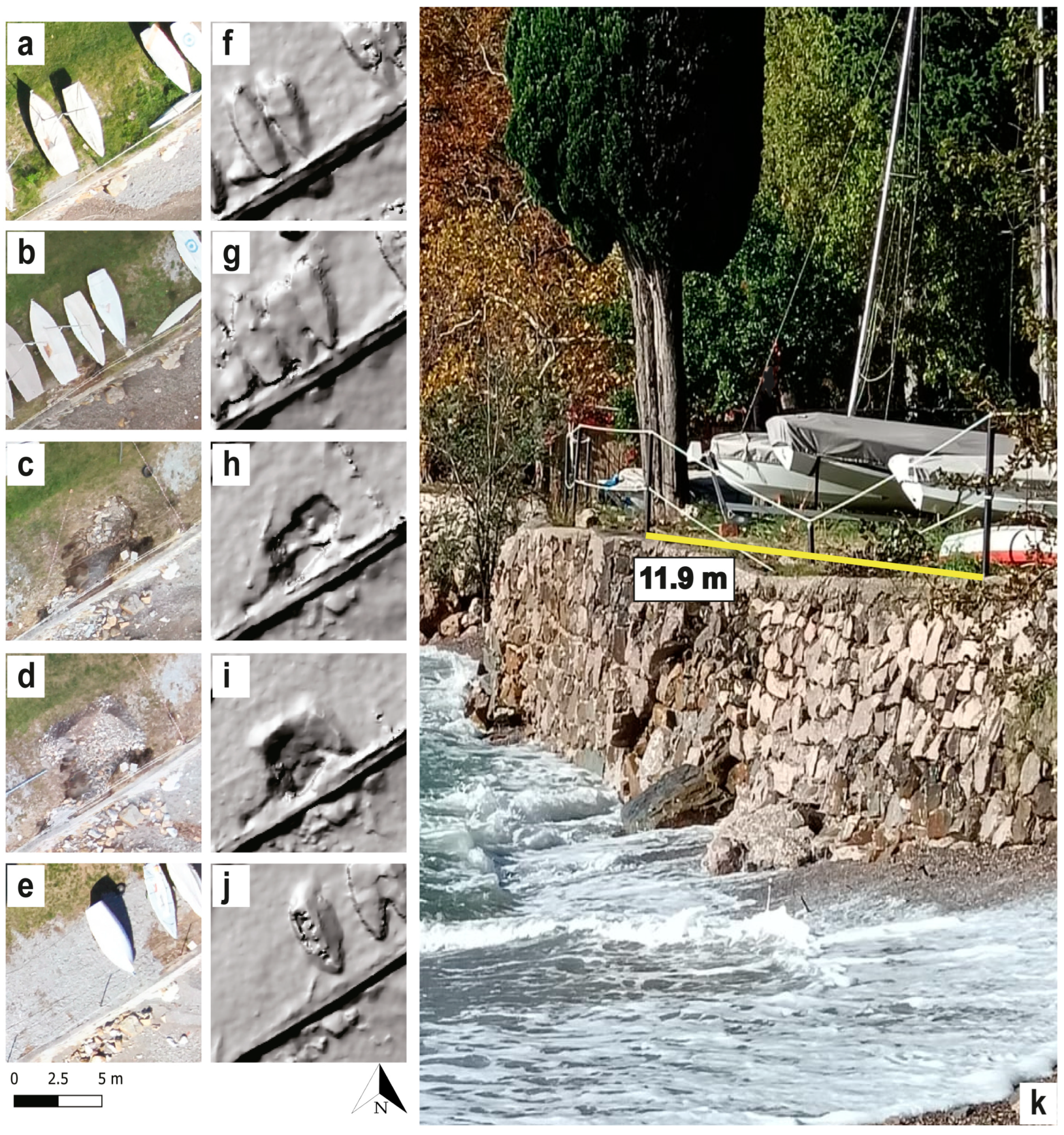


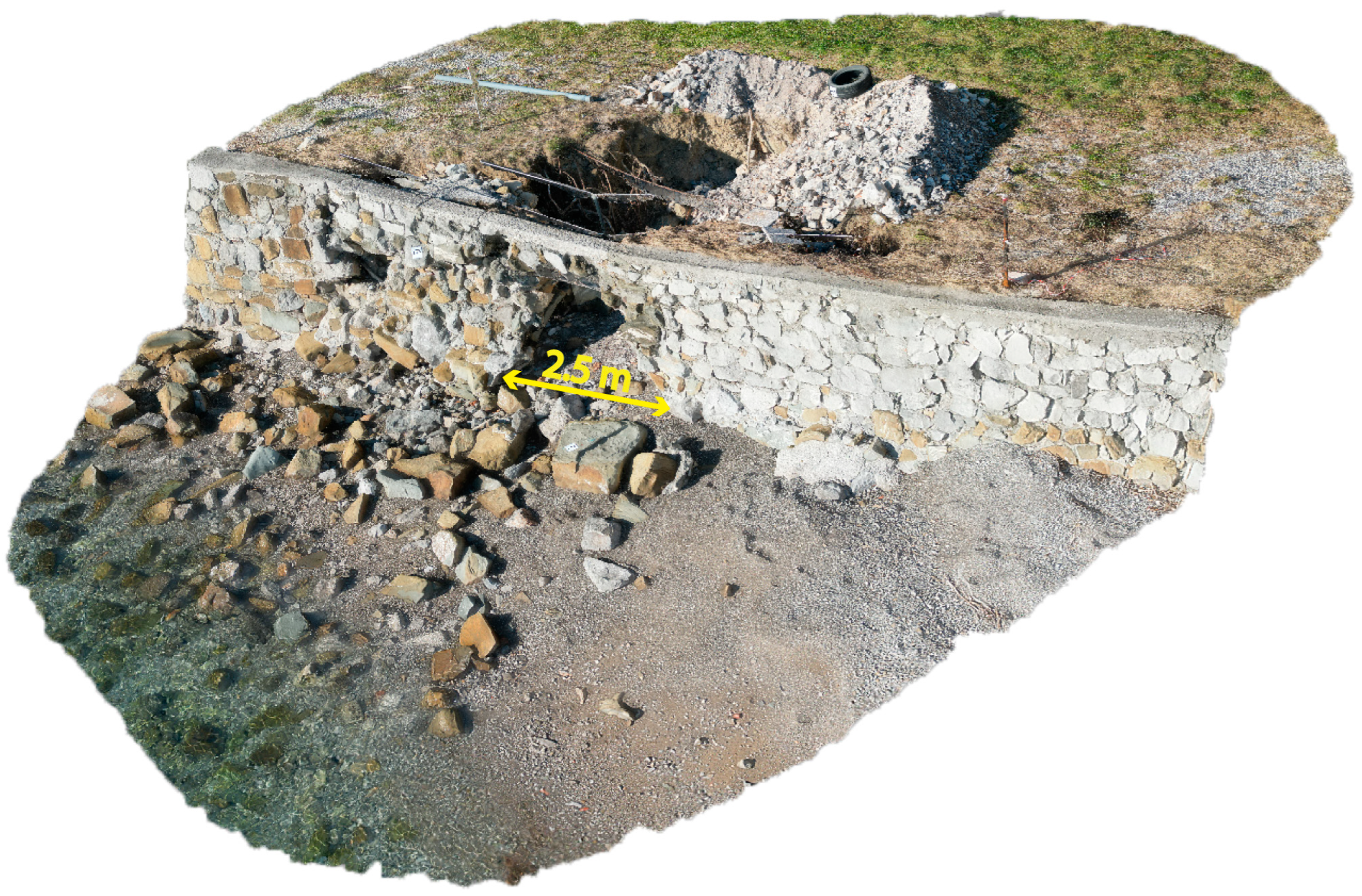
| Storm Event | Storm Date | Hs (Direction) at DWRG1 [m] | Wind Speed (Direction) at Paloma [m/s] |
|---|---|---|---|
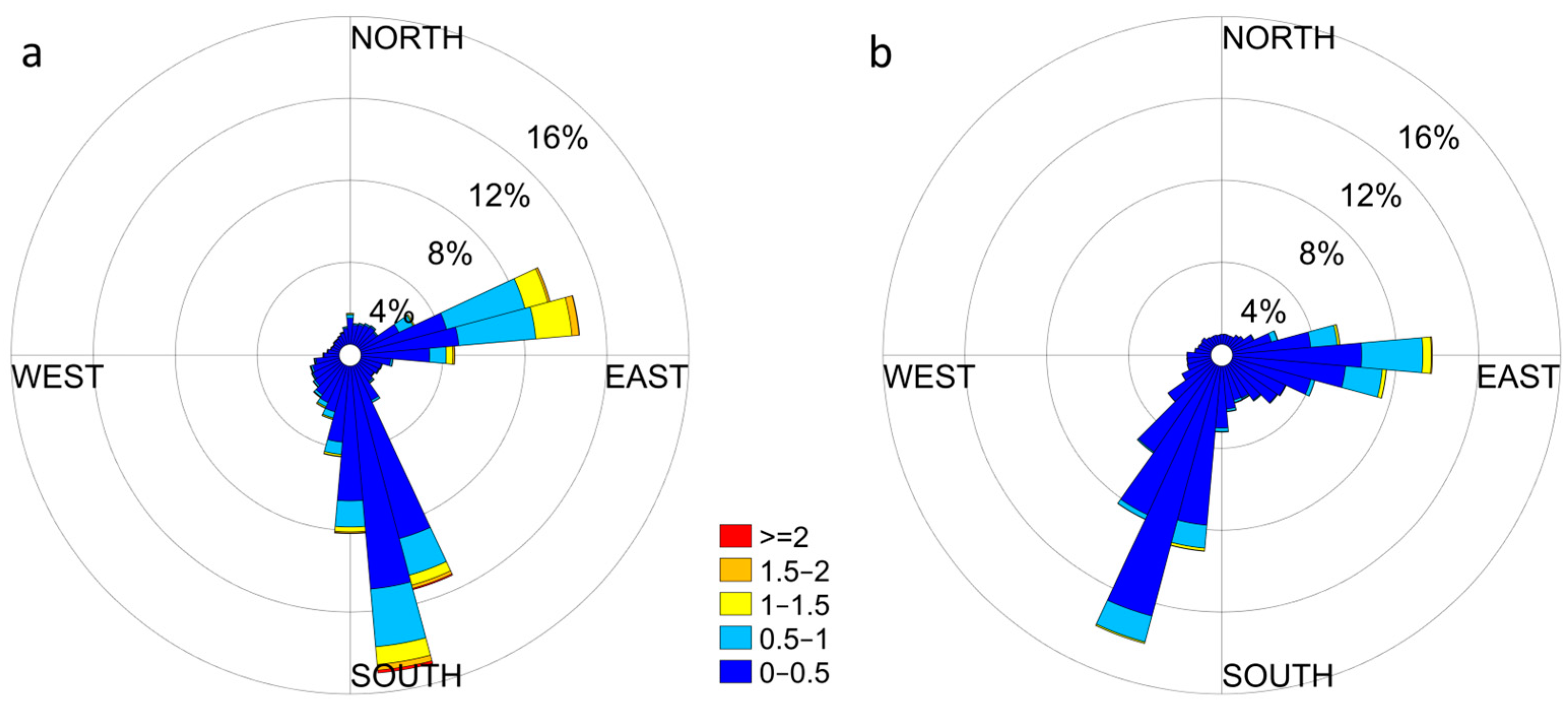
| EVENT 1 | 27 October 2023 06:00 | 2.26 (170°N) | 15.0 (220°N) |
| EVENT 2 | 30 October 2023 20:30 | 2.28 (166°N) | 12.2 (179°N) |
| EVENT 3 | 31 October 2023 13:00 | 2.07 (205°N) | 13.9 (265°N) |
| EVENT 4 | 2 November 2023 17:30 | 3.24 (175°N) | 12.2 (187°N) |
| EVENT 5 | 3 November 2023 14:00 | 2.72 (197°N) | 18.3 (221°N) |
| EVENT 6 | 5 November 2023 03:00 | 3.77 (172°N) | 14.7 (235°N) |
| Storm Event | Storm Date | Hs at Sistiana Mare [m] | Hs Sistiana Mare/HS DWRG1 (%) | Time over 1 m Threshold [Hours:Minutes] |
|---|---|---|---|---|
| EVENT 1 | 27 October 2023 06:00 | 1.30 | 58% | 3:50 |
| EVENT 2 | 30 October 2023 20:30 | 0.67 | 29% | - |
| EVENT 3 | 31 October 2023 13:00 | 1.24 | 60% | 2:00 |
| EVENT 4 | 2 November 2023 17:30 | 0.97 | 30% | - |
| EVENT 5 | 3 November 2023 14:00 | 1.81 | 67% | 8:35 |
| EVENT 6 | 5 m November 2023 03:00 | 1.08 | 29% | 1:05 |
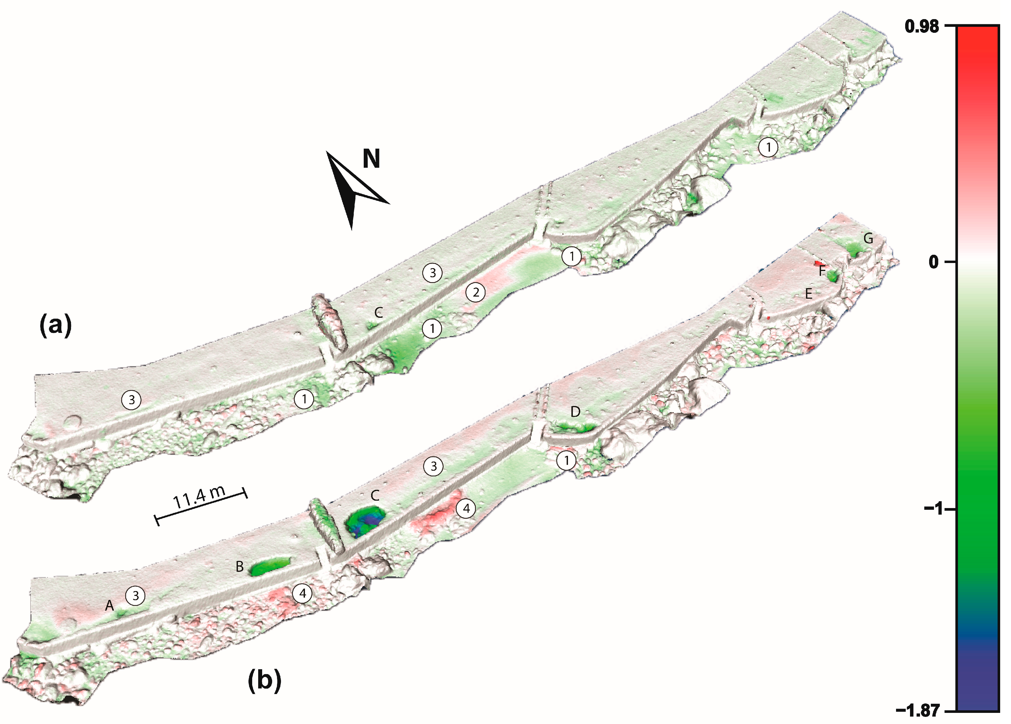
| Sinkhole | Major Axis (a) [m] | Minor Axis (b) [m] |
Flattening Factor | Maximum Depth [m] | Perimeter [m] | Area [m2] |
|---|---|---|---|---|---|---|
| A | 1.68 | 1.21 | 0.28 | 0.30 | 4.77 | 1.37 |
| B | 5.69 | 2.01 | 0.65 | 1.18 | 13.21 | 9.18 |
| C | 5.72 | 3.64 | 0.36 | 1.87 | 15.81 | 17.04 |
| D | 6.86 | 2.39 | 0.65 | 1.06 | 16.31 | 11.67 |
| E | 1.40 | 1.15 | 0.18 | 0.26 * | 4.31 | 1.03 |
| F | 3.24 | 2.12 | 0.35 | 0.84 | 8.75 | 5.39 |
| G | 3.89 | 3.68 | 0.05 | 0.80 | 13.28 | 9.88 |
| H | 5.84 | 2.87 | 0.51 | 1.68 | 14.79 | 13.05 |
Disclaimer/Publisher’s Note: The statements, opinions and data contained in all publications are solely those of the individual author(s) and contributor(s) and not of MDPI and/or the editor(s). MDPI and/or the editor(s) disclaim responsibility for any injury to people or property resulting from any ideas, methods, instructions or products referred to in the content. |
© 2024 by the authors. Licensee MDPI, Basel, Switzerland. This article is an open access article distributed under the terms and conditions of the Creative Commons Attribution (CC BY) license (https://creativecommons.org/licenses/by/4.0/).
Share and Cite
Busetti, A.; Leone, C.; Corradetti, A.; Fracaros, S.; Spadotto, S.; Rai, P.; Zini, L.; Calligaris, C. Coastal Storm-Induced Sinkholes: Insights from Unmanned Aerial Vehicle Monitoring. Remote Sens. 2024, 16, 3681. https://doi.org/10.3390/rs16193681
Busetti A, Leone C, Corradetti A, Fracaros S, Spadotto S, Rai P, Zini L, Calligaris C. Coastal Storm-Induced Sinkholes: Insights from Unmanned Aerial Vehicle Monitoring. Remote Sensing. 2024; 16(19):3681. https://doi.org/10.3390/rs16193681
Chicago/Turabian StyleBusetti, Alice, Christian Leone, Amerigo Corradetti, Saverio Fracaros, Sebastian Spadotto, Pietro Rai, Luca Zini, and Chiara Calligaris. 2024. "Coastal Storm-Induced Sinkholes: Insights from Unmanned Aerial Vehicle Monitoring" Remote Sensing 16, no. 19: 3681. https://doi.org/10.3390/rs16193681
APA StyleBusetti, A., Leone, C., Corradetti, A., Fracaros, S., Spadotto, S., Rai, P., Zini, L., & Calligaris, C. (2024). Coastal Storm-Induced Sinkholes: Insights from Unmanned Aerial Vehicle Monitoring. Remote Sensing, 16(19), 3681. https://doi.org/10.3390/rs16193681


