Article

Complex Discontinuity Structure Beneath the Changbaishan-Tianchi Volcano Revealed by the P-Wave Coda Autocorrelation Method Based on Dense Seismic Array

1
College of Geoexploration Science and Technology, Jilin University, Changchun 130026, China
2
Changbai Volcano Geophysical Observatory, Ministry of Education, Jilin University, Changchun 130026, China
*
Author to whom correspondence should be addressed.
Remote Sens. 2024, 16(19), 3615; https://doi.org/10.3390/rs16193615
Submission received: 29 August 2024 / Revised: 24 September 2024 / Accepted: 26 September 2024 / Published: 27 September 2024

Abstract

:
The Changbai volcano, a globally recognized hotspot of volcanic activity, has garnered significant attention due to its persistent seismicity and ongoing magma activity. The volcano’s discontinuities and magma dynamics have raised concerns about the likelihood of future eruptions, which would likely result in substantial ecological, climatic, and economic impacts. Consequently, a comprehensive understanding of the Changbai volcanic system is essential for mitigating the risks associated with volcanic activity. In recent years, the P-wave coda autocorrelation method has gained popularity in lithosphere exploration as a reliable technique for detecting reflection coefficients. Additionally, the Common Reflection Point stacking approach has been employed to superimpose reflection signals in a spatial grid, enabling continuous observation of reflection coefficients in the study area. However, the accuracy of this approach is heavily reliant on better spatial data coverage. To better understand the internal dynamics of the Changbai volcano, we applied this approach to a densely packed short-period seismic array with an average station spacing of less than 1 km. Our results were constrained using waveform data of reflection coefficients and Moho dip angles. Our findings revealed a discontinuity in the Moho, which may indicate a conduit for mantle magma entering the crust. Furthermore, we identified two low-velocity anomalies within the crust, likely representing a magma chamber comprising molten and crystallized magma. Notably, our results also provided a clear definition of the lithosphere–asthenosphere boundary.

1. Introduction

1.1. Geologic Background

The Northeast China region is situated in the easternmost region of the Central Asian Orogenic Belt, situated between the Siberian Plate and the North China Plate. It is characterized by long-term subduction of the Pacific Plate on its eastern flank. The Changbai volcano, located on the border between China and North Korea, marks the forearc region of the Pacific Plate’s subduction process. The specific location of Changbai volcano is shown in Figure 1. The genesis and activity of the Changbai volcano magmatic system have garnered considerable interest among geologists. Notably, the Changbai volcano is the largest intra-plate volcano in Northeast Asia, characterized by a volcanic field comprising a substantial volume of Cenozoic basalt erupted during the early Paleogene to late Quaternary period [1,2,3]. The Changbai volcano is currently one of the most actively monitored and hazardous volcanoes in Northeast Asia, distinguished by a rich history of frequent and intense volcanic eruptions. Volcanic activity in the Changbai volcano commenced during the Pliocene epoch and continued through the late Pleistocene period. Notably, the volcano experienced a significant eruption during the Holocene epoch, which resulted in the formation of the Tianchi volcanic crater. Various studies indicate that the Changbai volcano’s ongoing volcanic activity may portend future eruptions [4,5,6,7,8,9,10,11,12,13,14,15,16]. Once the Changbai volcano erupts, the resulting ecological, climatic, and economic losses would be enormous.
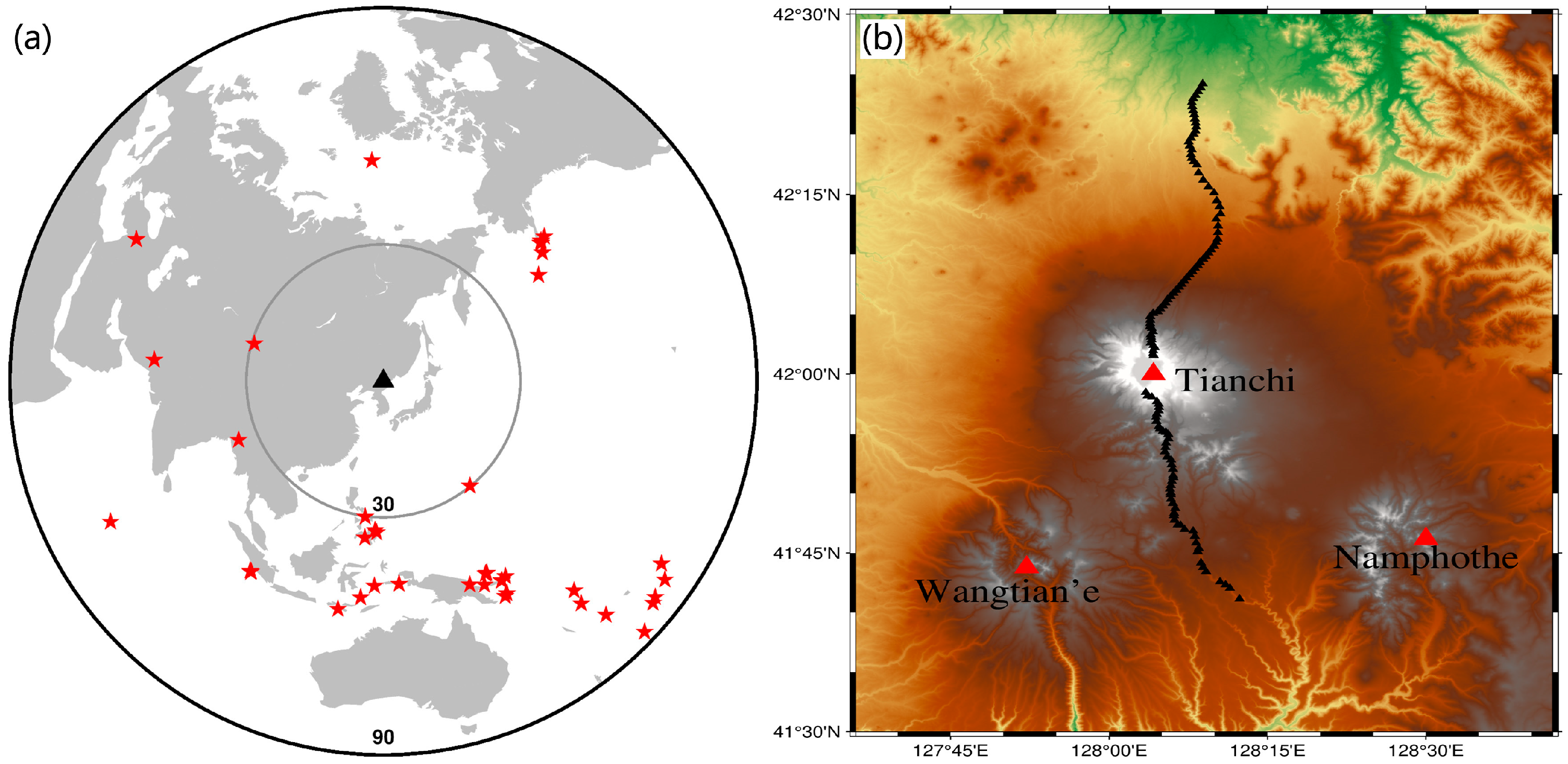
The Changbai volcano area comprises multiple volcanic craters, primarily including the Tianchi volcano, the Wangtian’e volcano, and the Namphothe volcano located in North Korea. The first serves as the main peak, situated in the central region of the Changbai volcano, with the second and third located at the distance of 35 km southwest and 45 km southeast of Tianchi, respectively. These volcanoes are interconnected within a shared volcanic system, drawing their thermal impetus from a common source in the Earth’s upper mantle, and manifest comparable patterns of volcanic activity. Notably, the Changbai volcano exemplifies a composite nature, having undergone episodic phases of eruption throughout its geological history. This characteristic multi-stage eruptive behavior is reflective of the dynamic interplay between magma replenishment and crustal structure, shaping the distinctive morphology and eruptive history of the Changbai volcanic edifice [17,18,19,20].
Global-scale three-dimensional tomographic imaging and receiver function studies indicate a significant high-velocity anomaly at depths ranging from 441 to 660 km. The Pacific Plate started its subduction at the Japan trench and arrived at the mantle transition zone (MTZ). The origin of the Changbai volcano system is closely linked to the dehydration process of the big mantle wedge (BMW) formed by the subducting plate. It can be inferred that Changbai volcano is highly likely to be an intraplate volcano formed by the dehydration process of the stagnated plate [17,21,22,23,24]. The Changbai volcano is situated at the forefront of plate subduction, where the dehydration-induced melting of material leads to the upwelling of upper mantle material, resulting in lithospheric thinning. Furthermore, the local extension of the lithosphere induced by the Dunhua–Mishan Fault (DMF) has resulted in decompression melting in the asthenosphere [25]. This has led to significant vertical material flow in the upper mantle, resulting in complex geological structures and pronounced uplift of the lithosphere–asthenosphere boundary (LAB) compared to surrounding areas. The crust in the Changbai volcano region is thicker than in surrounding areas due to magma activity and the expansion of the Songliao Basin [1,16,26,27], providing a favorable environment for magma storage. Various studies in magnetotelluric, geochemistry, geology, and other fields have consistently indicated the presence of magma chambers within the crust with high heat values [27,28,29,30,31,32], strongly suggesting the existence of molten magma [1,16,26].
This research utilizes autocorrelation analysis of P-wave codas to enhance the understanding of magma chamber distribution and the structure of the magmatic system beneath the Changbai volcano area. This approach will advance our knowledge of the formation, migration, and storage mechanisms of magma beneath the Changbai volcano, which is essential for improving predictions and assessments of volcanic hazards.

1.2. P-Wave Coda Autocorrelation

This method employs the autocorrelation of transmitted waves to derive a reflective response. Claerbout in 1968 introduced the concept that reflection signals from horizontally layered media can be deduced through the autocorrelation of transmitted signals [33]. As a seismic signal propagates beneath a seismic station, it is captured by the station and descends almost vertically at the surface, reflecting off interfaces where velocity discontinuities occur, before being captured again by the station. The autocorrelation of this seismic signal produces reflection signals. Wapenaar in 2003 expanded this theory to include arbitrary media [34].
The P-wave coda autocorrelation technique, also referred to as global-phase seismic interferometry (GloPSI) [35], seismic daylight imaging (SDI) [36], and the Vertical Receiver Function method or ‘generalized RFs’ [37,38], is multifaceted in its approach. Typically, earthquake signals utilized in these methods are derived from teleseismic phases or global phases such as PKIKP, or they are harvested from ambient noise serving as transmission signals [39,40,41]. Sun in 2016 initially implemented autocorrelation on teleseismic seismograms, capitalizing on the distinct and efficient propagation paths characteristic of teleseismic events [36]. Analogous to the Receiver Function technique, autocorrelation entails the convolution of seismic signals to extract data from subsurface interfaces, a process described as ‘virtual deep seismic sounding’ [37,38]. Relative to the Receiver Function methodology, autocorrelation provides an extended frequency bandwidth and enhanced resolution, as reported by Sun and Kennett in 2016 and 2017 [42,43]. Moreover, it offers an economical alternative to deep seismic reflection techniques for acquiring reflectivity data. Seismic daylight imaging (SDI) has proven highly effective in imaging interfaces and has been extensively utilized in studies of lithospheric structures. Owing to its inherent mechanism of near-vertical seismic signal reflection, P-wave coda autocorrelation boasts considerable benefits in horizontal resolution when examining subsurface interfaces and structures with moderate dips. Its straightforward data processing approach and minimal operational prerequisites render P-wave coda autocorrelation particularly amenable for use with sparsely spaced seismic networks or even isolated seismometers, thereby enabling the detection of large-scale reflectivity patterns. In the present research, P-wave coda autocorrelation is employed on a closely spaced seismic profile with an average inter-station distance of less than 0.5 km to more accurately pinpoint the horizontal locations of shallow magma chambers.

2. Data and Method

Figure 2b depicts the tightly configured short-period seismic array consisting of 122 stations that were established across the Changbai volcano in 2020, featuring an average inter-station distance of under 1 km. The instrument we use is EPS, with a detection time of one month. This compact arrangement of stations enhances the resolution of lateral heterogeneities in the geological formations, as discussed by Liang in 2020 [44]. The overall profile extends in a north–south direction, passing through the Tianchi volcano caldera in the middle, and the southern segment traverses the foot of the Wangtian’e and Namphothe volcanoes. We selected teleseismic seismograms with epicentral distances ranging from 30 to 90° recorded during the station deployment period, with relatively small ray parameters, meeting the requirements for autocorrelation analysis. Figure 2a depicts the distribution of seismic events. We imposed a magnitude threshold of 5 or higher to ensure an adequate signal-to-noise ratio. A total of 44 earthquakes meeting these criteria were selected. The data window was set from 20 s before the P-wave arrival to 160 s afterward, totaling 180 s. Finally, seismic data with a high signal-to-noise ratio and good data quality were selected.
Upon data acquisition, the initial step involved preprocessing, which included removing the mean, detrending, and eliminating spikes. Subsequently, spectral whitening was applied to the data. During the long-distance propagation of teleseismic earthquakes, some frequency bands may undergo considerable signal attenuation. Spectral whitening was employed to amplify these weakened signals [45]. The selected frequency band for data filtering critically influences the resolution of the imaged structures. The P-wave coda autocorrelation technique employs a broader and higher-frequency spectrum compared to that typically used for receiver functions. For instance, Ruigrok and Wapenaar in 2012 conducted imaging of the 80 km deep Moho discontinuity in the Tibetan Plateau using frequencies between 0.01 and 2 Hz [35]. Similarly, Gorbatov, Kennett and Sippl, and others utilized frequency bands extending up to 4 Hz to image lithospheric structures [39,41]. In our study, with the objective of imaging both the lithosphere and the crust, we opted for the frequency ranges of 0.1 to 1 Hz and 0.3 to 5 Hz, correspondingly.
Following the execution of autocorrelation, we employed the Common Reflection Point (CRP) stacking technique [38,41] to aggregate the reflectivity signals within designated grid cells. As illustrated in Figure 3a, this technique enhances the Common Conversion Point (CCP) methodology traditionally applied in receiver function analysis [46]. Upon obtaining the ray parameters from teleseismic seismograms and integrating them with the subsurface velocity model of the study area, we were able to map the ray paths of seismic propagation. While these ray paths are inherently three-dimensional, for improved imaging outcomes within a 2D profile, we projected them onto the profile direction. Figure 3b illustrates a schematic representation of the seismic ray paths as recorded by five stations. In this instance, we employed the USTClitho2.0 velocity model [47], which provides a relatively detailed delineation of subsurface velocities across a span of 150 km on the Chinese mainland. Given that the inter-station distance is approximately 1 km, we opted for a grid resolution of 0.5 km to facilitate our study.
The autocorrelation operation produces an impulse signal at zero time, which results in a substantial detection blind zone in the autocorrelation method. This blind zone hinders the identification of shallow geological structures and varies depending on the frequency of the seismic signal. In previous studies using autocorrelation, many researchers have employed cosine windowing to mitigate the impulse response. However, in our study of shallow areas, applying cosine windowing would significantly affect the outcomes. Consequently, we opted not to use this step in our analysis. Ultimately, we performed smoothing and selected regions with a denser distribution of ray paths for the final profile results. Additionally, we generated waveform plots for individual stations. Following a similar approach to the CRP, we first preprocess the raw teleseismic data. Subsequently, we apply a 4 Hz low-pass filter to the data and then stack all the signals received at each station to produce a composite record. For individual station stacking, we used Phase-Weighted Stacking (PWS) [48], which stacks seismic signals received at a station below each other. The advantage of this method is that it emphasizes consistent phase during stacking:
g ( t ) = 1 N N j = 1 s j ( t ) | 1 N N k = 1 e x p [ i ϕ k ( t ) ] | υ
where exp i ϕ k t represents the phase components of the seismic signal, while ν denotes the order of PWS. When ν = 0, it indicates linear stacking. It is essential to recognize that PWS can lead to waveform distortion and potentially poorer stacking outcomes when phase errors are present. In this study, we set v = 1. Indeed, this method may yield diminished reflectivity resolution for interfaces within complex subsurface structures. Nonetheless, within a specific depth range, it remains feasible to discern the characteristics of reflectivity. This method provides a comprehensive reflection representation of the subsurface directly beneath the station.
Zhou proposed a new constraint for the P-wave coda autocorrelation [49]. The conventional assumption for seismic data stacking is that subsurface interfaces are horizontal. In this case, the arrival time of the reflected seismic waves at the receiver stations is only dependent on the depth of the interface, P-wave velocity, and ray parameters. However, real subsurface interfaces are generally not horizontal. When considering the presence of a certain angle of inclination for an interface, the arrival time equation for the P-wave reflection becomes
t p p = t 0 v p cos ϕ n p R 2
where t p p represents the travel time of the PP phase, t 0 is the time taken for seismic waves to propagate vertically, v p denotes the P-wave velocity, ϕ represents the dip angle of the layer, n is the normal vector to the interface, and p R represents the ray parameter. We used this method to constrain the depth of the Moho and obtained a rough assessment of its morphology.

3. Results

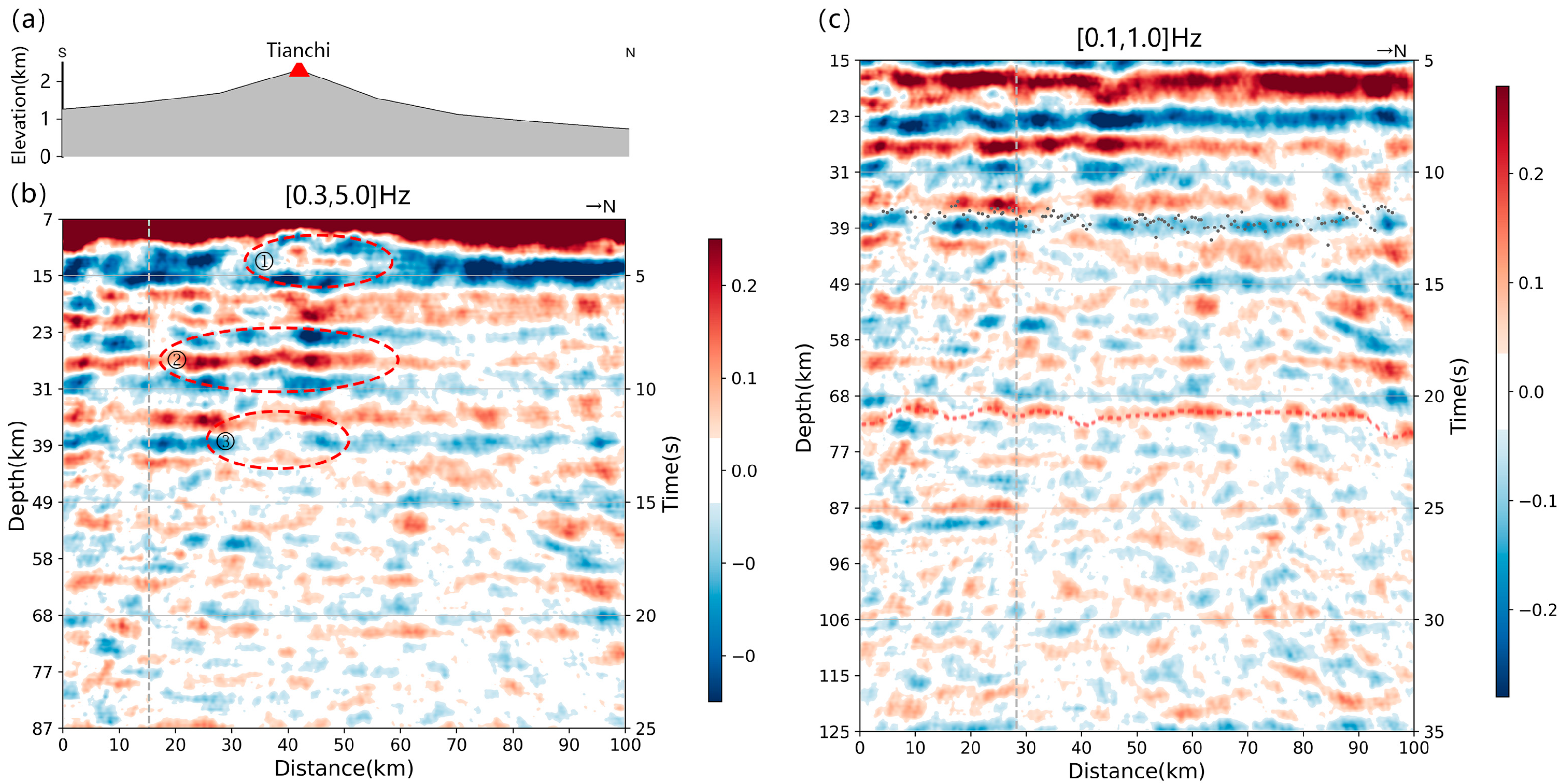
We selected a densely sampled region, achieving a profile length of approximately 100 km, oriented primarily in a north–south direction. The southern segment of the profile traverses the base of the Wangtian’e and Namphothe volcanoes, while it also intersects the Tianchi volcano at the distance of 45 km away. Additionally, at both ends of the CRP profile, a phenomenon of larger-than-normal amplitudes is observed due to sparse ray distributions. Therefore, careful interpretation is required in these areas. Figure 4a displays a frequency range of 0.3–5 Hz, which is frequently utilized for examining interfaces within the Earth’s crust. In contrast to the receiver function method that typically concentrates on frequencies below 1 Hz, P-wave coda autocorrelation employs a broader and higher frequency range, facilitating more detailed imaging of crustal interfaces. During the autocorrelation processing of the data, a zero-time impulse signal is generated, resulting in a detection blind zone in the imaging. The size of the detection blind zone is dependent on both the selected frequency range and the dominant frequency of the incoming seismic signal. Within the 0.3–5 Hz frequency band depicted in the image, we observe a blind zone extending approximately 4 s, which corresponds to a spatial distance of around 10 km. This dimension represents roughly the smallest blind zone achievable with the teleseismic seismograms utilized in our study. The energy manifested in the P-wave coda autocorrelation is predominantly associated with the PP reflection phase, making the method particularly adept at imaging horizontal or near-horizontal interfaces. Conversely, its capability to accurately represent inclined or vertically aligned interfaces is comparatively constrained. The CRP stacking process averages the data in the horizontal plane, which tends to produce an image profile with a predominance of horizontal amplitude features.
The Moho is characterized by a high-velocity positive-polarity phase. This phase emerges due to the inversion caused by the reflection of seismic signals at the interface devoid of air, resulting in a positive-polarity phase at high-velocity interfaces, which is identified by a red–blue–red amplitude pattern. The energy associated with the Moho originates from a depth of approximately 38 km, aligning with findings from receiver functions studies [50,51]. In Figure 4b, the energy of the crustal reflections on the southern side of the Tianchi volcano is noticeably greater than that on the northern side. Supporting this observation, Zhang used artificial seismic sources to measure depth and found that north of the Tianchi volcano, crustal velocity changes are relatively gradual [52]. In contrast, the southern region exhibits more substantial variations in velocity, indicative of a complex crustal structure that is likely to produce more complex reflection signals. Zhang in 2018 identified a fault directly beneath the Tianchi volcano, trending northwest to southeast at depths of less than 50 km [53]. North of this fault, there is a subsidence of approximately 1 mm per year, while the southern part exhibits an uplift of about 1–2 mm per year. This fault facilitates the intrusion of mantle-derived melt into the crust. Furthermore, the southern part of the Tianchi volcano features a thicker crust, which is conducive to magma storage. This contributes to a more complex crustal composition and higher reflectivity. Additionally, our findings reveal a marked reduction in energy near the Moho beneath the Tianchi volcano, as particularly evidenced at position 3 in Figure 4b. Within the context of the P-wave coda autocorrelation method, the reflectivity magnitude is contingent upon the contrast in reflection coefficients at the interface and the attenuation of energy as seismic waves propagate. Consequently, the energy anomaly observed at this position could be indicative of anomalous physical properties and the complexity of the overlying strata in this region.
At approximately 15 km below the Tianchi volcano, a narrow negative-polarity low-velocity anomaly is evident at position 1 in Figure 4b, potentially indicating the presence of a magma chamber. In Figure 4b, the anomaly associated with the shallow magma chamber is not clearly visible due to the interference from shallow seismic pulses. To address this issue, we present Figure 5, which is an improved version of Figure 4b. Specifically, we calculate the average amplitude at different depths and then subtract this average value from each point to produce Figure 5. This processing enhances the visibility of the anomaly at location 1 in Figure 4b, making it more apparent. Supporting this interpretation, the joint inversion analysis conducted by Zhu in 2019, which utilized receiver functions and ambient noise data, identified widespread low-velocity anomalies in the middle to upper crust beneath the Tianchi volcano [54]. Notably, a distinct low-velocity anomaly was detected at depths ranging from 8 to 15 km, which is speculated to be a magma chamber. Geothermal studies have revealed exceptionally high temperatures in the hot wells near Tianchi, with simulated temperatures surpassing the partial melting points of granite and andesite. These elevated temperatures are found at relatively shallow depths within the Earth’s crust [55]. Correspondingly, magnetotelluric studies have detected low-resistivity anomalies at these locations, further supported by geological and geochemical investigations which suggest the potential existence of a magma chamber [27,30,31,32]. Analyses of the magma reservoir beneath the Changbai volcano point to a probable mantle-derived heat source, signifying an ongoing magmatic conduit extending from the mantle to the crustal magma reservoir. This mantle-sourced magmatism may play a critical role in driving future volcanic activity, as suggested by various studies [14,21,28,55,56].
Approximately 30 km south of the Tianchi volcano, at a depth of around 30 km beneath the Wangtian’e volcano, a prominent velocity anomaly is evident at position 2 in Figure 4b. In the profile, this anomaly presents as a low-velocity, negative-polarity feature from a depth of approximately 20 to 40 km and as a high-velocity interface with positive polarity from a depth of 40 to 50 km, contrasting with the overlying magma chamber. Gravity surveys conducted in the area have also identified density anomalies with similar characteristics beneath the Tianchi volcano. Constrained by seismic exploration profiles [52], a large-scale 3D modeling effort was undertaken, which revealed the existence of low-density, irregularly shaped columnar magma reservoirs beneath the Changbai Mountain Tianchi Volcano, Wangtian’e Volcano, and Namphothe Volcano [26,57]. From a petrophysical perspective, this location is highly likely to correspond to the mafic intrusive body described in Kim’s study, suggesting that it may be a cumulate of Changbai mafic magma [19].
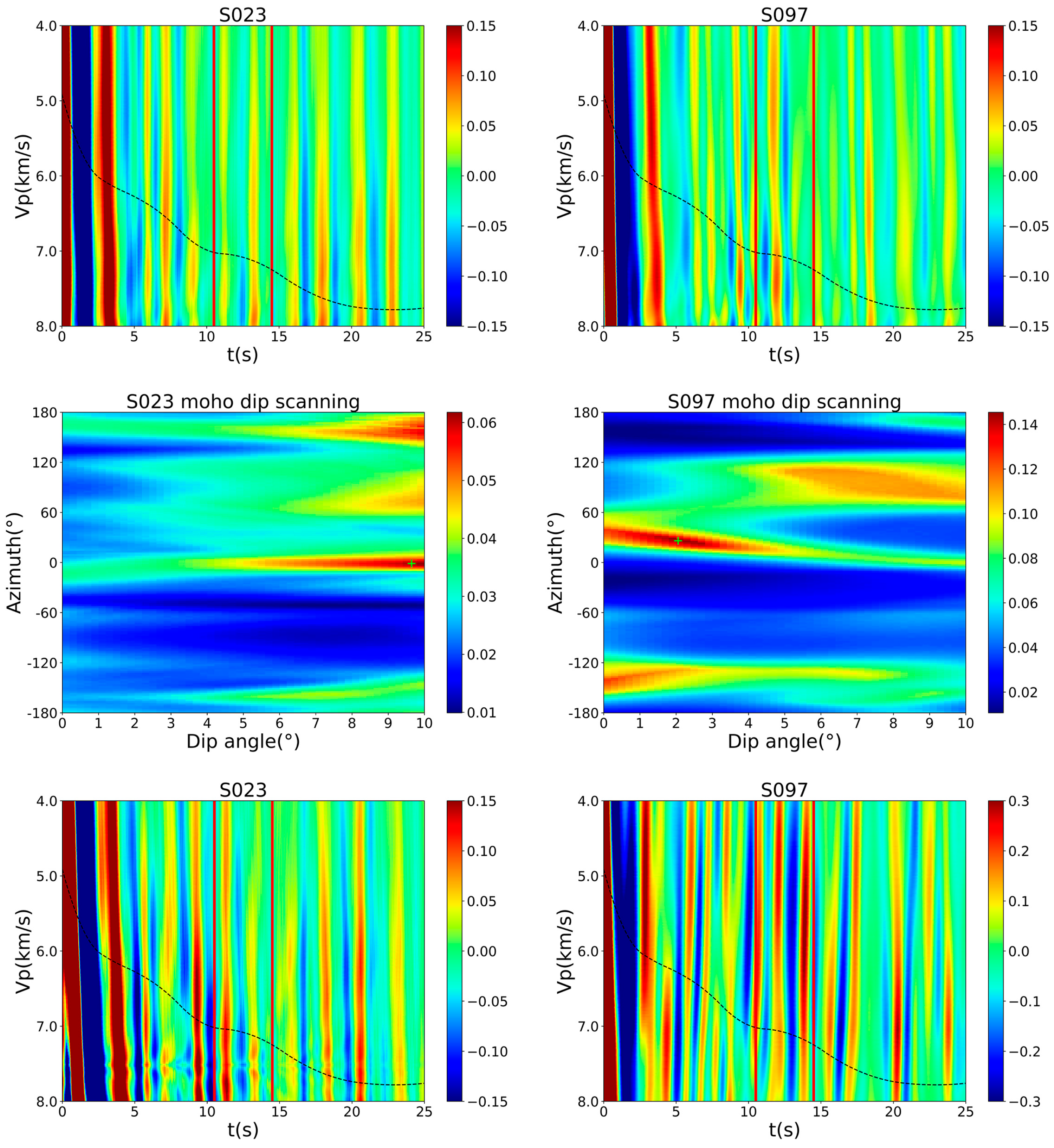
In the images within the 0.1 to 1 Hz frequency band, as illustrated in Figure 4c, the detection blind zone is observed to extend to about 7.5 s, which is approximately equivalent to a depth of 25 km. In Figure 4c, which represents the [0.1, 1] Hz frequency range, the filtering of some high-frequency reflection energy results in the enhanced prominence of the Moho energy signature. The gray dots positioned at the Moho depth denote estimates derived from dip spectrum scanning results. Figure 6 presents the results of dip spectrum and velocity scanning for two stations. We stack the seismic signals with different dip parameters and set a window around the prior Moho position, with a duration of 2 s before and after the expected arrival time. The average energy within this window is then calculated to produce the dip spectrum. Within the dip spectrum results, the location of maximum cumulative energy indicates the magnitude of the interface’s dip angle and its orientation, while the velocity analysis outcomes yield the average P-wave reflection velocity at the Moho interface. As evident from Figure 7, the Moho beneath the Changbai volcano region predominantly exhibits a north–south inclination. Moreover, the profile demonstrates a trend of the Moho becoming shallower as it approaches the northern extremity.
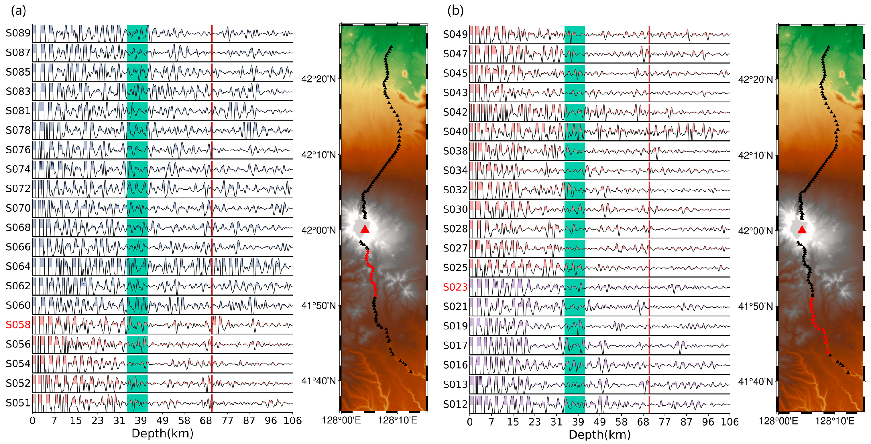
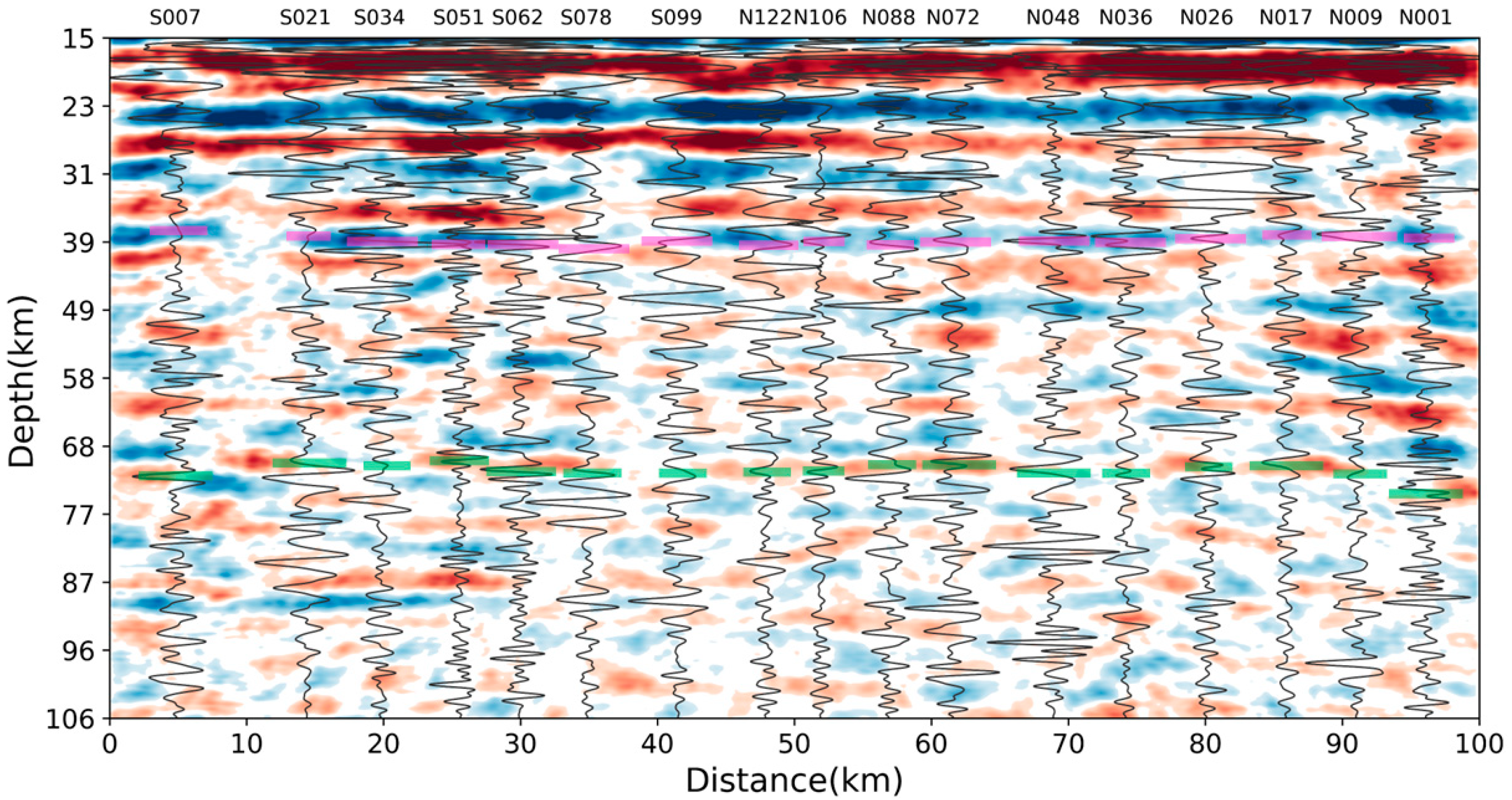
Figure 8 displays the stacked autocorrelation results from a single station. Utilizing the single-station Phase-Weighted Stacking method, the results show variations in both amplitude and frequency, which help to elucidate the patterns in geological structures beneath the station. The red dashed line in this figure marks the observed position of the lithosphere–asthenosphere boundary (LAB) from our analysis, while the green bands highlight the average position of the Moho across our profile. The waveforms are segmented into three distinct regions by two interfaces: the crust, the bottom of the lithosphere, and the asthenosphere. Notably, the reflectivity amplitudes near Tianchi are distinctly clear. Moving southward from Tianchi, there is a significant shift in the reflectivity characteristics. The gray dashed line in Figure 4c marks the position of station S058. Moving from north to south, particularly near station S058, there is a noticeable decrease in waveform amplitude at the bottom of the lithosphere. This observation suggests a transition from complex to simpler structures at this depth, potentially linked to varying levels of magmatic activity in the lower lithosphere. Near station S023, a significant reduction in crustal reflections is observed, likely reflecting the extent of crystallization of mafic magma within the crust. In Figure 8a, north of S060, the blue waveform is located within 20 km of Tianchi. This region corresponds to the CRP profile, where a shallow magma chamber, a lower crustal magma chamber, and active magmatic activity at the base of the lithosphere are inferred to exist. These features result in a complex geological structure, leading to a complex waveform with high frequency and large amplitude over a significant depth range. The red waveform is approximately located between 20 and 40 km from Tianchi. In this region, only a cooled magma chamber in the lower crust is present, resulting in relatively clear crustal reflections. The purple waveform is located beyond 40 km from Tianchi. This region has a relatively simple geological structure. This can also explain why multiple Moho reflections are observed at the northern end of the profile (87 km in Figure 4c). The simpler medium and more pronounced Moho reflection are consistent with the observed waveform characteristics. For individual stations such as S064 and S040, both the amplitude and frequency of the waveforms exhibit significant variations compared to those of surrounding stations. These differences may be indicative of anomalies in the subsurface geology specific to these local areas. To better illustrate the response of the interface positions, we compare the single-station stacked signals with the [0.1–1] Hz profile in Figure 4c. As shown in Figure 9, the single-station stacked signals exhibit a more pronounced onset in the vicinity of the Moho and LAB interfaces. In contrast, at stations far from Tianchi, such as S007, N017, and N009, the amplitude of the stacked signals is relatively small at depths of 40–70 km, corresponding to the bottom of the lithosphere. In contrast, at stations closer to Tianchi, such as S099, the energy is larger and the waveforms are more complex. This suggests that the geological structure beneath Tianchi is more complex.
The location of the lithosphere–asthenosphere boundary (LAB) beneath the Changbai volcano remains a subject of considerable debate. The LAB is characterized as a negatively polarized low-velocity interface. Detection results from receiver functions generally place the LAB interface between 80 and 110 km deep [58,59]. In contrast, magnetotelluric studies of the Earth’s crust suggest that the shallowest part of the LAB may be around 50 km deep [25]. Additionally, geothermal studies estimate the boundary of the lithosphere to be between 40 and 60 km deep [60,61]. These findings predominantly stem from large-scale explorations covering the entire Northeast China region. Our profile results indicate that horizontally stratified energy bands consistently extend to approximately 70 km deep. This stratification persists even deeper towards the southern end of the profile, reaching depths of around 87 km. Below this depth, the image energy diminishes, marked by irregularities, a lack of stratification, and discontinuities. These observations suggest a complex and variable structure of the LAB beneath the Changbai volcano. Observations from the stacking results of individual stations indicate that the medium within the crust north of station S023 is relatively simple, exhibiting less attenuation during the propagation of seismic waves. Moreover, the horizontally stratified energy band observed at a depth of 87 km corresponds precisely to twice the travel time to the Moho, suggesting that the reflection energy at this position may be due to multiple waves originating from the Moho interface. Considering these observations, it is suggested that the LAB likely occurs around 70 km deep.

4. Discussion

4.1. Moho Discontinuity

Around 10 km south of the Tianchi volcano, an energy gap is observed at the Moho discontinuity, as indicated at position 3 in Figure 4b. When considering the P-wave coda autocorrelation in the context of the specific geological conditions at the Changbai volcano, the abrupt reduction in reflection energy may be attributed to two potential causes. The first is the presence of molten magma deep within the crust beneath Tianchi. Studies involving receiver functions and ambient noise have detected high velocity ratios in this region, indicative of molten material that has the potential to diminish the reflective capacity of P-waves [19,53,62]. Secondly, Kim’s study using ambient noise identified velocity anomalies within the crust, including a significant high velocity ratio anomaly at the depth of the Moho discontinuity. This anomaly is attributed to the formation of a basaltic magma base, resulting from mantle-derived mafic magma underplating. Such underplating leads to gradual lithological changes at the Moho discontinuity, diminishing the impedance contrast and thereby reducing the P-wave reflection energy. Consequently, this location may act as a conduit for mantle-derived material entering the crust, influencing the seismic properties observed at this depth.

4.2. Lower Crustal Low-Velocity Body

Within the profile at position 2 in Figure 4b, at a depth of around 30 km, a conspicuous low-velocity anomaly with negative polarity and intense energy is evident, which may denote the presence of cooled granitic crystalline material. This interpretation is supported by analogous density anomalies identified in gravity surveys [17], and is consistent with Kim’s findings, which refer to composite bodies of solidified granitic magma. Research suggests that the magma chamber beneath Mt. Wangtian’e has undergone complete cooling [19]. The volcanic activity within the Changbai volcano region historically exhibits a close temporal correlation with the activity along the Dunmi Fault (DMF), with their respective periods of activity showing significant overlap. The DMF, along with its subsidiary faults, serves as conduits for magma ascent, promotes decompression within the lithosphere and asthenosphere, and triggers localized melting. These processes collectively energize volcanic activity in the region. The volcanic eruptions at Mt. Wangtian’e occurred prior to those at the Tianchi and Namphothe volcanoes, with their respective periods of activity more closely mirroring the timeline of fault activity [1,16,17,63]. Given the solidified state of the magma chamber beneath Mt. Wangtian’e and the ongoing volcanic activity at the Tianchi and Namphothe volcanoes, it is plausible to deduce that the tectonic activity has modified the magmatic pathways.

4.3. Shallow Magma Chamber

Our findings indicate a low-velocity negative-polarity anomaly in the middle-upper crust at approximately 15 km beneath Tianchi, as shown at position 1 in Figure 4b. This anomaly is supported by numerous studies, including the joint inversion of ambient noise and receiver functions, which suggests the presence of a low-velocity anomaly at depths ranging from 8 to 30 km, potentially indicative of a magma chamber [51]. Additionally, magnetotelluric surveys at the same location reveal a high-conductivity anomaly, suggesting the presence of molten magma [27]. Geothermal studies in the Changbai volcano region point to an exceptionally high heat flow background, with temperatures that exceed the partial melting temperatures of granite and andesite. These thermal effects are located in the middle-upper crust, distinct from areas of crystal-rich, cooled-condensed magma. Beneath this region, a magma supply channel suggests ongoing mantle-derived thermal material replenishment rather than a gradual cooling of existing magma [21,28,55]. Geological studies further corroborate this dynamic system, identifying basaltic cover in the volcanic area of Changbai, which aligns with the continuous activity and heat supply from deeper mantle sources.

4.4. LAB

The LAB we have identified is situated at a depth of approximately 70 km, which aligns with findings that are intermediate between those of receiver functions and the thermal lithosphere. The LAB interface, as a zone of more active material flow, experiences significant shifts in both its physical and chemical properties. These changes could be associated with abrupt temperature gradients and a transition from a more dehydrated lithosphere to a hydrated and fertile asthenosphere below [58,64]. In areas at the leading edge of plate subduction zones, the dehydration-induced melting of upper mantle constituents can lead to the ascent of hot materials, which, in turn, results in a notable uplift of the LAB interface across the eastern sector of the Northeast China region. S-wave velocity imaging results indicate that hot mantle material beneath the Changbai volcano ascends to approximately 60 km of depth from the mantle transition zone. This upwelling induces the formation of a high-speed material descending flow along the southern edge of the Songliao Basin, resulting in small-scale convection beneath the Northeast China region [65]. Furthermore, studies on thermal structures have identified significantly high-temperature zones within the volcanic lithosphere of the Changbai volcano. Remarkably, compared to surrounding areas, the volcanic region of this volcano features the thinnest lithosphere [61]. Magnetotelluric sounding data also indicate a pronounced uplift of the LAB interface along the subduction front of the Pacific Plate [25], suggesting dynamic geological processes at play beneath this region.
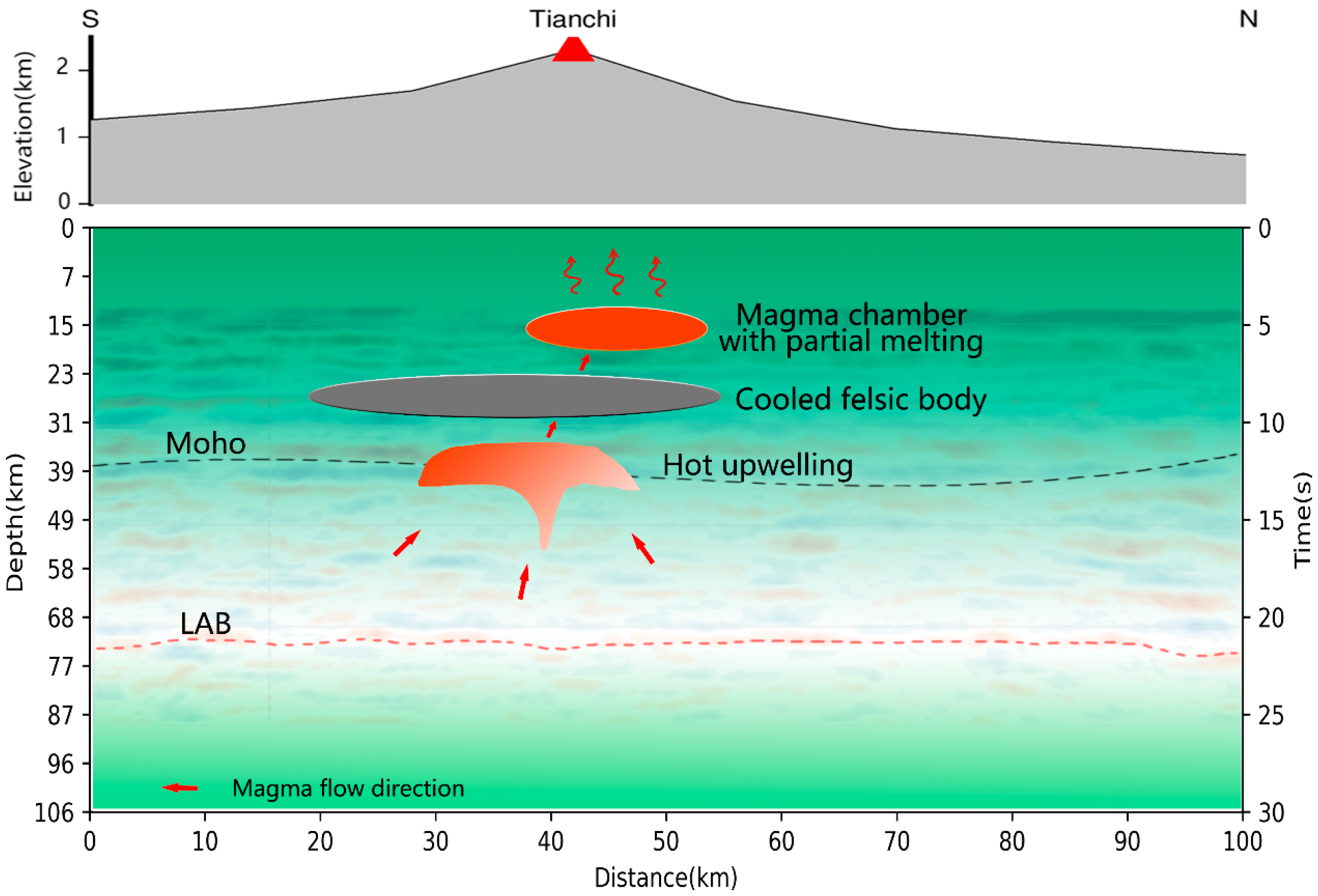
Figure 10 depicts a schematic of the magma system we detected, highlighting various components including shallow magma chambers, a mid-lower crustal cooled felsic body, and detailed interface characteristics. The Moho is represented by depth estimates derived from tilt spectrum fitting, while the LAB corresponds to indications from our profile analysis. The schematic illustrates how upwelling, driven by the subduction of the Pacific Plate, reaches the base of the lithosphere via the upper mantle. Fault activity facilitates this process, providing both the force and pathways necessary for magma movements, leading magma to ascend into the crust from beneath Tianchi through gaps at the Moho. Given the detection of molten magma in shallow magma chambers and its likely mantle-origin supply, we infer that this magma enters the crust and travels through magma channels into these magma chambers. In geochemical studies, magma chambers at shallower depths (3.5–8 km) form under reducing conditions. The evolution of melts is associated with their degassing and magma mixing, ultimately leading to strong enrichments in trace elements (Th, Nb, Ta, Zr, and REE) in pantellerite and comendite melts (Andreeva et al., 2018). Evidence for magma chambers at even shallower depths (within 10 km) has been found in geological, petrological, and magnetotelluric studies. Combined with the detection of many seismic events occurring at shallow depths, it can be inferred that the Changbaishan volcano remains active [14,27,30,32]. In summary, there are still signs of magmatic activity in areas beyond our current research focus, which requires further investigation using additional methods. This dynamic process underscores the complex interplay between tectonic activities and magmatic systems in the region, highlighting the critical role of fault dynamics in shaping volcanic phenomena.

5. Conclusions

In this study, we used the P-wave coda autocorrelation method based on a dense array of stations to obtain a more detailed reflection image of the Changbai volcano volcanic region. The main findings are as follows.
  • We imaged the lithosphere–asthenosphere boundary (LAB) at a depth of approximately 70 km, accompanied by notable reflectivity features at the base of the lithosphere.
  • Our findings identified two distinct low-velocity anomalies with negative polarity. The first anomaly, positioned at a shallow depth of approximately 15 km, aligns with previous research indicating the existence of a magma chamber filled with molten magma. The second anomaly, located approximately 30 km beneath the Wangtian’e volcano in the southern part of Tianchi, corresponds to a cooled felsic body.
  • A significant energy attenuation phenomenon was observed at the Moho position beneath Tianchi, suggesting a potential pathway for magma to enter the crust. Previous research has indicated the presence of molten magma in the deep crust beneath the Changbai volcano, with a magma chamber being continuously supplied by thermal material from the mantle. The observed decrease in P-wave reflectivity at this location may be attributed to the presence of molten magma or the deposition of cooled magma resulting from ongoing magmatic activity. Based on these observations, we propose that this location likely serves as a conduit for magma entry into the crust.

Author Contributions

Data curation, formal analysis, writing—original draft preparation, H.W.; data curation, formal analysis, writing—review and editing, funding acquisition, Y.T.; supervision, formal analysis, C.L.; data curation, formal analysis, H.L. All authors have read and agreed to the published version of the manuscript.

Funding

This study was supported by the National Natural Science Foundation of China (Grant No. 42274065), the National Key R&D Program of China (Grant No. 2022YFF0801003), and Fundamental Research Funds for the Central Universities in China.

Informed Consent Statement

Informed consent was obtained from all subjects involved in the study.

Data Availability Statement

The raw data will be made available on request.

Acknowledgments

The staff involved are thanked for their efforts, with complex logistics and trying conditions.

Conflicts of Interest

The authors declare no conflicts of interest.

References

  1. Liu, J.; Han, J.; Fyfe, W.S. Cenozoic episodic volcanism and continental rifting in northeast China and possible link to Japan Sea development as revealed from K–Ar geochronology. Tectonophysics 2001, 339, 385–401. [Google Scholar] [CrossRef]
  2. Wang, Y.; Li, C.; Wei, H.; Shan, X. Late Pliocene–recent tectonic setting for the Tianchi volcanic zone, Changbai Mountains, northeast China. J. Asian Earth Sci. 2003, 21, 1159–1170. [Google Scholar] [CrossRef]
  3. Wei, H.; Liu, G.; Gill, J. Review of eruptive activity at Tianchi volcano, Changbaishan, northeast China: Implications for possible future eruptions. Bull. Volcanol. 2013, 75, 1–14. [Google Scholar] [CrossRef]
  4. Fan, Q.; Liu, R.; Zhang, G.; Sui, J. The Genesis and Evolution of Bimodal Volcanic Rocks in Wangtian'e Volcano, Changbaishan. Yanshi Xuebao/Acta Petrol. Sin. 1998, 14, 305–317. [Google Scholar]
  5. Fan, Q.; Liu, R.; Li, D.; Li, Q. Significance of K-Ar age of bimodal volcanic rocks at Wangtian' e volcano, Changbaishan area. Chin. Sci. Bull. 1999, 44, 660–663. [Google Scholar] [CrossRef]
  6. Liu, J.; Pan, J.; Naik, S.; Santangini, H.; Trenkler, D.; Thompson, N.; Rifai, A.; Chowdhury, J.R.; Jauregui, H.O. Characterization and Evaluation of Detoxification Functions of a Nontumorigenic Immortalized Porcine Hepatocyte Cell Line (HepLiu). Cell Transplantation 1999, 8, 219–232. [Google Scholar] [CrossRef]
  7. Horn, S.; Schmincke, H.U. Volatile emission during the eruption of Baitoushan Volcano (China/North Korea) ca. 969 AD. Bull. Volcanol. 2000, 61, 537–555. [Google Scholar] [CrossRef]
  8. Oppenheimer, C. Ice core and palaeoclimatic evidence for the timing and nature of the great mid-13th century volcanic eruption. Int. J. Climatol. 2003, 23, 417–426. [Google Scholar] [CrossRef]
  9. Taniguchi, H. Carbohydrate research and industry in Japan and the Japanese society of applied glycoscience. Starch/Staerke 2004, 56, 1–5. [Google Scholar] [CrossRef]
  10. Guo, Z.; Hertogen, J.; Liu, J.; Pasteels, P.; Boven, A.; Punzalan, L.; He, H.; Luo, X.; Zhang, W. Potassic magmatism in western Sichuan and Yunnan Provinces, SE Tibet, China: Petrological and geochemical constraints on petrogenesis. J. Petrol. 2005, 46, 33–78. [Google Scholar] [CrossRef]
  11. Stone, R. Is China’s Riskiest Volcano Stirring or Merely Biding Its Time? Science 2010, 329, 498–499. [Google Scholar] [CrossRef] [PubMed]
  12. Chu, S.K.W.; Chan, K.H.; Yu, K.Y.; Ng, H.T.; Wong, W.K. An empirical study of the impact of intellectual capital on business performance. J. Inf. Knowl. Manag. 2011, 10, 11–21. [Google Scholar] [CrossRef]
  13. Stone, R. Vigil at North Korea's Mount Doom. Science 2011, 334, 584–588. [Google Scholar] [CrossRef] [PubMed]
  14. Xu, J.; Liu, G.; Wu, J.; Ming, Y.; Wang, Q.; Cui, D.; Shangguan, Z.; Pan, B.; Lin, X.; Liu, J. Recent unrest of Changbaishan volcano, northeast China: A precursor of a future eruption? Geophys. Res. Lett. 2012, 39, L16305. [Google Scholar] [CrossRef]
  15. Yin, J.; Jull, A.J.T.; Burr, G.S.; Zheng, Y. A wiggle-match age for the Millennium eruption of Tianchi Volcano at Changbaishan, Northeastern China. Quat. Sci. Rev. 2012, 47, 150–159. [Google Scholar] [CrossRef]
  16. Liu, J.-q.; Chen, S.-s.; Guo, Z.-f.; Guo, W.-f.; He, H.-y.; You, H.-t.; Kim, H.-m.; Sung, G.-h.; Kim, H. Geological background and geodynamic mechanism of Mt. Changbai volcanoes on the China–Korea border. Lithos 2015, 236–237, 46–73. [Google Scholar] [CrossRef]
  17. Choi, S.; Oh, C.-W.; Götze, H.-J. Three-dimensional density modeling of the EGM2008 gravity field over the Mount Paekdu volcanic area. J. Geophys. Res. Solid Earth 2013, 118, 3820–3836. [Google Scholar] [CrossRef]
  18. Liu, Z.; Niu, F.; Chen, Y.J.; Grand, S.; Kawakatsu, H.; Ning, J.; Tanaka, S.; Obayashi, M.; Ni, J. Receiver function images of the mantle transition zone beneath NE China: New constraints on intraplate volcanism, deep subduction and their potential link. Earth Planet. Sci. Lett. 2015, 412, 101–111. [Google Scholar] [CrossRef]
  19. Kim, S.; Tkalčić, H.; Rhie, J. Seismic constraints on magma evolution beneath Mount Baekdu (Changbai) volcano from transdimensional Bayesian inversion of ambient noise data. J. Geophys. Res. Solid Earth 2017, 122, 5452–5473. [Google Scholar] [CrossRef]
  20. Li, H.; Tian, Y.; Zhao, D.; Kumar, R.; Li, H.; Yan, D.; Liu, C. Shear-wave tomography of the Changbai volcanic area in NE China derived from ambient noise and seismic surface waves. J. Asian Earth Sci. 2023, 258, 105482. [Google Scholar] [CrossRef]
  21. Zhao, D.; Lei, J.; Tang, R. Origin of the Changbai intraplate volcanism in Northeast China: Evidence from seismic tomography. Chin. Sci. Bull. 2004, 49, 1401–1408. [Google Scholar] [CrossRef]
  22. Lei, J.; Zhao, D. P-wave tomography and origin of the Changbai intraplate volcano in Northeast Asia. Tectonophysics 2005, 397, 281–295. [Google Scholar] [CrossRef]
  23. Zhao, D.; Maruyama, S.; Omori, S. Mantle dynamics of Western Pacific and East Asia: Insight from seismic tomography and mineral physics. Gondwana Res. 2007, 11, 120–131. [Google Scholar] [CrossRef]
  24. Tian, Y.; Zhu, H.; Zhao, D.; Liu, C.; Feng, X.; Liu, T.; Ma, J. Mantle transition zone structure beneath the Changbai volcano: Insight into deep slab dehydration and hot upwelling near the 410 km discontinuity. J. Geophys. Res. Solid Earth 2016, 121, 5794–5808. [Google Scholar] [CrossRef]
  25. Zhou, Z.; Wang, D.; Wang, T.; Weng, A.; Li, Y.; Guo, J.; Wang, X. Undulating electrical lithosphere–asthenosphere boundary beneath Northeast China; as revealed by long–period magnetotelluric data. Tectonophysics 2023, 851, 229770. [Google Scholar] [CrossRef]
  26. Zhang, G.C.; Wu, Q.J.; Pan, J.T.; Zhang, F.X.; Yu, D.X. Study of crustal structure and Poisson ratio of NE China by H-K stack and CCP stack methods. Acta Geophys. Sin. 2013, 56, 4084–4094. [Google Scholar] [CrossRef]
  27. Yang, B.; Lin, W.; Hu, X.; Fang, H.; Qiu, G.; Wang, G. The magma system beneath Changbaishan-Tianchi Volcano, China/North Korea: Constraints from three-dimensional magnetotelluric imaging. J. Volcanol. Geotherm. Res. 2021, 419, 107385. [Google Scholar] [CrossRef]
  28. Tang, J.; Zhao, G.; Wang, J.J.; Zhan, Y.; Deng, Q.H.; Chen, X. Study of the formation mechanism for volcanism in Northeast China based on deep electric structure. Acta Petrol. Sin. 2006, 22, 1503–1510. [Google Scholar]
  29. Qiu, G.G.; Pei, F.G.; Fang, H.; Du, B.R.; Zhang, X.B.; Zhang, P.H.; Yan, Y.Z.; He, M.X.; Bai, D.W. Analysis of magma chamber at the Tianchi volcano area in Changbai mountain. Chin. J. Geophys. 2014, 10, 3466–3477. [Google Scholar]
  30. Pan, B.; de Silva, S.L.; Xu, J.; Chen, Z.; Miggins, D.P.; Wei, H. The VEI-7 Millennium eruption, Changbaishan-Tianchi volcano, China/DPRK: New field, petrological, and chemical constraints on stratigraphy, volcanology, and magma dynamics. J. Volcanol. Geotherm. Res. 2017, 343, 45–59. [Google Scholar] [CrossRef]
  31. Andreeva, O.A.; Yarmolyuk, V.V.; Andreeva, I.A.; Borisovskiy, S.E. Magmatic Evolution of Changbaishan Tianchi Volcano, China–North Korea: Evidence from Mineral-Hosted Melt and Fluid Inclusions. Petrology 2018, 26, 515–545. [Google Scholar] [CrossRef]
  32. Yi, J.; Wang, P.; Shan, X.; Ventura, G.; Wu, C.; Guo, J.; Liu, P.; Li, J. Modeling the multi-level plumbing system of the Changbaishan caldera from geochemical, mineralogical, Sr-Nd isotopic and integrated geophysical data. Geosci. Front. 2021, 12, 101171. [Google Scholar] [CrossRef]
  33. Claerbout, J.F. Synthesis of a layered medium from its acoustic transmission response. Geophysics 1968, 33, 264–269. [Google Scholar] [CrossRef]
  34. Wapenaar, K. Synthesis of an inhomogeneous medium from its acoustic transmission response. Geophysics 2003, 68, 1756–1759. [Google Scholar] [CrossRef]
  35. Ruigrok, E.; Wapenaar, K. Global-phase seismic interferometry unveils P-wave reflectivity below the Himalayas and Tibet. Geophys. Res. Lett. 2012, 39, L11303. [Google Scholar] [CrossRef]
  36. Sun, W.; Kennett, B.L.N. Receiver structure from teleseisms: Autocorrelation and cross correlation. Geophys. Res. Lett. 2016, 43, 6234–6242. [Google Scholar] [CrossRef]
  37. Galetti, E.; Curtis, A. Generalised receiver functions and seismic interferometry. Tectonophysics 2012, 532–535, 532–535,. [Google Scholar] [CrossRef]
  38. Tauzin, B.; Phạm, T.S.; Tkalčić, H. Receiver functions from seismic interferometry: A practical guide. Geophys. J. Int. 2019, 217, 1–24. [Google Scholar] [CrossRef]
  39. Gorbatov, A.; Saygin, E.; Kennett, B.L.N. Crustal properties from seismic station autocorrelograms. Geophys. J. Int. 2013, 192, 861–870. [Google Scholar] [CrossRef]
  40. Becker, G.; Knapmeyer-Endrun, B. Crustal thickness across the Trans-European Suture Zone from ambient noise autocorrelations. Geophys. J. Int. 2018, 212, 1237–1254. [Google Scholar] [CrossRef]
  41. Kennett, B.L.N.; Sippl, C. Lithospheric discontinuities in Central Australia. Tectonophysics 2018, 744, 10–22. [Google Scholar] [CrossRef]
  42. Sun, W.; Kennett, B.L.N. Uppermost mantle P wavespeed structure beneath eastern China and its surroundings. Tectonophysics 2016, 683, 12–26. [Google Scholar] [CrossRef]
  43. Sun, W.; Kennett, B.L.N. Mid-lithosphere discontinuities beneath the western and central North China Craton. Geophys. Res. Lett. 2017, 44, 1302–1310. [Google Scholar] [CrossRef]
  44. Liang, S.; Kennett, B.L.N. Passive seismic imaging of a craton edge—Central Australia. Tectonophysics 2020, 797, 228662. [Google Scholar] [CrossRef]
  45. Phạm, T.-S.; Tkalčić, H. On the feasibility and use of teleseismic P wave coda autocorrelation for mapping shallow seismic discontinuities. J. Geophys. Res. Solid Earth 2017, 122, 3776–3791. [Google Scholar] [CrossRef]
  46. Dueker, K.G.; Sheehan, A.F. Mantle discontinuity structure from midpoint stacks of converted P to S waves across the Yellowstone hotspot track. J. Geophys. Res. Solid Earth 1997, 102, 8313–8327. [Google Scholar] [CrossRef]
  47. Han, S.; Zhang, H.; Xin, H.; Shen, W.; Yao, H. USTClitho2.0: Updated Unified Seismic Tomography Models for Continental China Lithosphere from Joint Inversion of Body-Wave Arrival Times and Surface-Wave Dispersion Data. Seismol. Res. Lett. 2021, 93, 201–215. [Google Scholar] [CrossRef]
  48. Schimmel, M.; Paulssen, H. Noise reduction and detection of weak, coherent signals through phase-weighted stacks. Geophys. J. Int. 1997, 130, 497–505. [Google Scholar] [CrossRef]
  49. Zhou, J.; Hu, N.; Hu, Y.; Zhang, W. Feasibility of Estimating Parameters and Enhancing Reflections of Dipping Moho From Teleseismic P Wave Coda Autocorrelation. J. Geophys. Res. Solid Earth 2022, 127, e2021JB023688. [Google Scholar] [CrossRef]
  50. Guo, Z.; Cao, Y.; Wang, X.; John Chen, Y.; Ning, J.; He, W.; Tang, Y.; Feng, Y. Crust and upper mantle structures beneath Northeast China from receiver function studies. Earthq. Sci. 2014, 27, 265–275. [Google Scholar] [CrossRef]
  51. Zhu, H.; Tian, Y.; Zhao, D.; Li, H.; Liu, C. Seismic Structure of the Changbai Intraplate Volcano in NE China From Joint Inversion of Ambient Noise and Receiver Functions. J. Geophys. Res. Solid Earth 2019, 124, 4984–5002. [Google Scholar] [CrossRef]
  52. Zhang, C.K.; Zhang, X.K.; Zhang, J.R.; Liu, B.F.; Zhang, J.S.; Yang, Z.X.; Hai, Y.; Sun, G.W. Study on the crustal and upper mantle structure in the Tianchi volcanic region and its adjacent area of Changbaishan. Chin. J. Geophys. 2002, 45, 812–820. (In Chinese) [Google Scholar]
  53. Zhang, M.; Guo, Z.; Liu, J.; Liu, G.; Zhang, L.; Lei, M.; Zhao, W.; Ma, L.; Sepe, V.; Ventura, G. The intraplate Changbaishan volcanic field (China/North Korea): A review on eruptive history, magma genesis, geodynamic significance, recent dynamics and potential hazards. Earth-Sci. Rev. 2018, 187, 19–52. [Google Scholar] [CrossRef]
  54. Zhu, G.; Liu, C.; Gu, C.; Zhang, S.; Li, Y.; Su, N.; Xiao, S. Oceanic plate subduction history in the western Pacific Ocean: Constraint from late Mesozoic evolution of the Tan-Lu Fault Zone. Sci. China Earth Sci. 2018, 61, 386–405. [Google Scholar] [CrossRef]
  55. Jiang, G.; Hu, S.; Cui, T.; Qian, C.; Liu, F.; Zhang, C.; Wang, Z.; Wang, Y.; Hou, T.; Tian, Y. Thermal structure beneath Changbaishan Volcano, northeastern Asia: New insights from temperature logging and numerical modelling. Geophys. J. Int. 2023, 235, 1228–1239. [Google Scholar] [CrossRef]
  56. Zhang, A.; Guo, Z.; Afonso, J.C.; Handley, H.; Dai, H.; Yang, Y.; Chen, Y.J. Lithosphere–asthenosphere interactions beneath northeast China and the origin of its intraplate volcanism. Geology 2021, 50, 210–215. [Google Scholar] [CrossRef]
  57. Guan, Y.W.; Choi, S.C.; Yang, G.D.; Liu, J.Q.; Lee, Y.S.; Oh, C.W.; Jin, X.; Wu, Y.G. Changbaishan Tianchi volcano crustal magma chambers modeling with gravity profile. Acta Petrol. Sin. 2020, 36, 3840–3852. [Google Scholar] [CrossRef]
  58. Meng, F.; Ai, Y.; Xu, T.; Chen, L.; Wang, X.; Li, L. Lithospheric structure beneath the boundary region of North China Craton and Xing Meng Orogenic Belt from S-receiver function analysis. Tectonophysics 2021, 818, 229067. [Google Scholar] [CrossRef]
  59. He, Y.; Chen, Q.-F.; Chen, L.; Wang, X.; Guo, G.; Li, T.; Zhang, K.; Li, J.; Chen, Y. Distinct Lithospheric Structure in the Xing'an-Mongolian Orogenic Belt. Geophys. Res. Lett. 2022, 49, e2021GL097283. [Google Scholar] [CrossRef]
  60. Jiang, G.; Hu, S.; Shi, Y.; Zhang, C.; Wang, Z.; Hu, D. Terrestrial heat flow of continental China: Updated dataset and tectonic implications. Tectonophysics 2019, 753, 36–48. [Google Scholar] [CrossRef]
  61. Yan, D.; Tian, Y.; Zhao, D.; Li, H. Thermal and rheological structure of lithosphere beneath Northeast China. Tectonophysics 2022, 840, 229560. [Google Scholar] [CrossRef]
  62. Kyong-Song, R.; Hammond, J.O.S.; Chol-Nam, K.; Hyok, K.; Yong-Gun, Y.; Gil-Jong, P.; Chong-Song, R.; Oppenheimer, C.; Liu, K.W.; Iacovino, K.; et al. Evidence for partial melt in the crust beneath Mt. Paektu (Changbaishan), Democratic People’s Republic of Korea and China. Sci. Adv. 2016, 2, e1501513. [Google Scholar] [CrossRef] [PubMed]
  63. Choi, H.-O.; Choi, S.H.; Schiano, P.; Cho, M.; Cluzel, N.; Devidal, J.-L.; Ha, K. Geochemistry of olivine-hosted melt inclusions in the Baekdusan (Changbaishan) basalts: Implications for recycling of oceanic crustal materials into the mantle source. Lithos. [CrossRef]
  64. Karato, S.-i.; Jung, H. Water, partial melting and the origin of the seismic low velocity and high attenuation zone in the upper mantle. Earth Planet. Sci. Lett. 1998, 157, 193–207. [Google Scholar] [CrossRef]
  65. Guo, Z.; Wang, K.; Yang, Y.; Tang, Y.; John Chen, Y.; Hung, S.-H. The Origin and Mantle Dynamics of Quaternary Intraplate Volcanism in Northeast China from Joint Inversion of Surface Wave and Body Wave. J. Geophys. Res. Solid Earth 2018, 123, 2410–2425. [Google Scholar] [CrossRef]
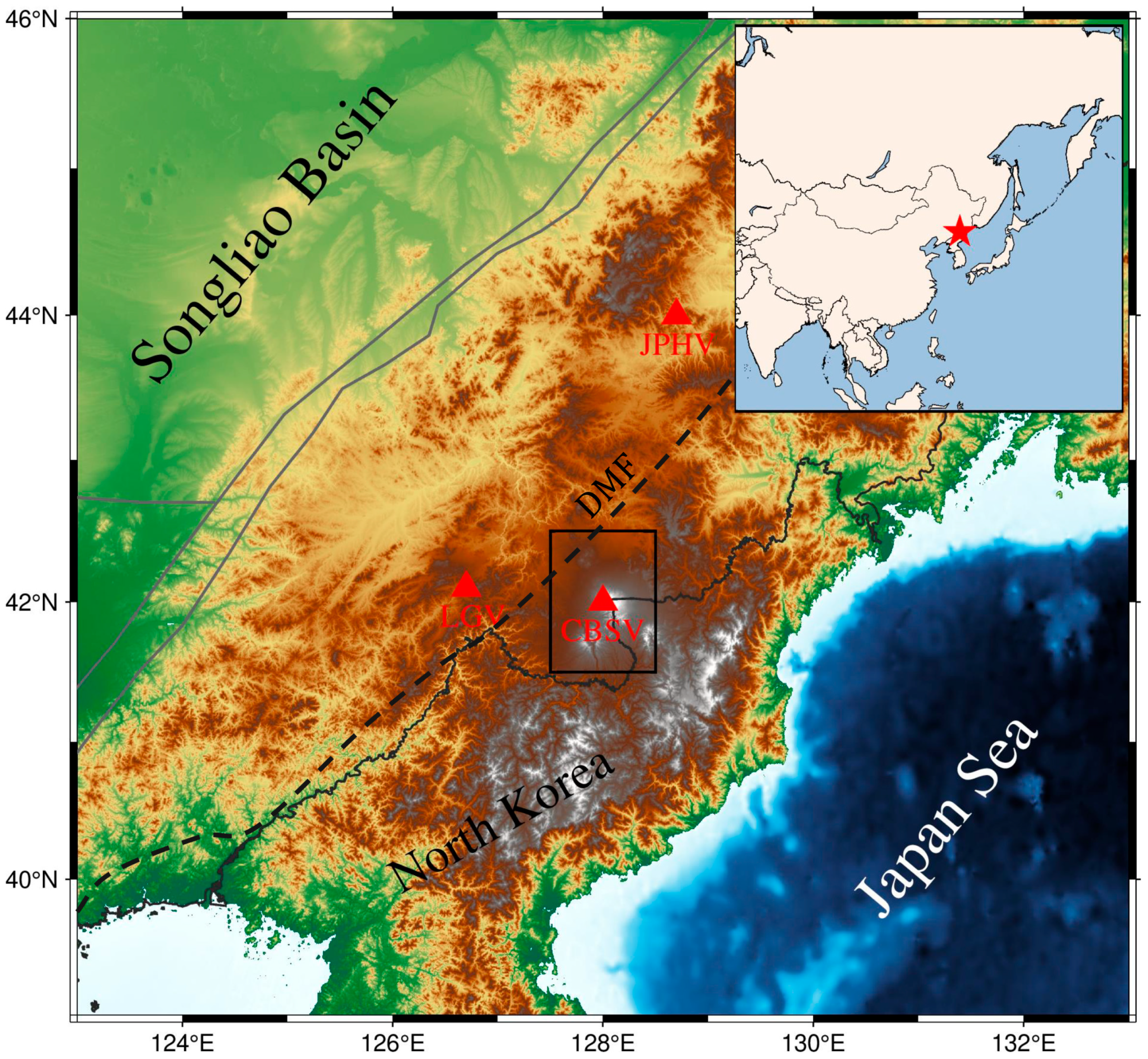
Figure 1. Location of the Changbai volcano. The gray solid line indicates the active tectonic-block boundary. Abbreviations are the Changbaishan Volcano (CBSV), the Longgang Volcano (LGV), and the Jingpohu Volcano (JPHV). The dashed black line indicates the Dunhua–Mishan Fault (DMF).
Remotesensing 16 03615 g001
Figure 2. (a) Distribution of the teleseismic events (red stars) used for this study. The black triangle is the location of the center of the study region. (b) The spatial locations of the stations used in this study. The black triangle represents the location of the station deployment.
Remotesensing 16 03615 g002
Figure 3. (a) Schematic diagram of the Common Reflection Point (CRP), showing the situation where a seismic station receives two different earthquakes. The reflectivity produced by the autocorrelation calculation at the interface position is equivalent to the reflection response of the virtual source at the corresponding position on the surface at this position. When the positions of the reflection points are close enough, they will be superimposed within the same grid, as shown in the red box. (b) The ray paths of earthquakes as received by five different stations.
Remotesensing 16 03615 g003
Figure 4. (a) The elevation of the location where the profile is located. (b) Reflection point imaging from teleseismic arrivals for the frequency band from 0.3 to 5.0 Hz. The location of station S023 is marked by a gray vertical dashed line. Three regions of anomalous reflectivity are encircled by red dashed circles. (c) Reflection point imaging from teleseismic arrivals for the frequency band from 0.1 to 1.0 Hz. Gray dots indicate the Moho depth estimates derived from the spectral tilting method. The position of station S058 is denoted by a gray vertical dashed line. The red dashed line demarcates the lithosphere–asthenosphere boundary (LAB) as determined by our study.
Remotesensing 16 03615 g004
Figure 5. Take the average of the energy values at each depth in Figure 4b and subtract the average value from all locations to obtain this figure. Compared to Figure 4b, this image more clearly reveals the anomaly associated with the shallow magma chamber.
Remotesensing 16 03615 g005
Figure 6. Velocity scans and dip spectrum results for selected stations ‘S023’ and ‘S097’. The first row illustrates the velocity analysis results at various interface depths, the second row showcases the results of dip scanning, and the third row presents velocity scans post-dip correction. Two red vertical lines mark the approximate position of the Moho, while the black dashed line indicates the USTClitho2.0 velocity model applied to the Changbai volcano study.
Remotesensing 16 03615 g006
Figure 7. (a) Statistical chart of the Moho depth estimation results. The results show that the Moho depth is approximately 38 km. The brown curve is the result of data fitting, and it can be seen that the Moho at the northern end has a tendency to become shallower. (b) The statistical results of the dip scans of all stations. Most of the blue dots are within the light-colored bands, which range from −30 to 30° and 150 to 210°. This indicates that the morphology of the Moho is mainly tilted in the north–south direction.
Remotesensing 16 03615 g007
Figure 8. The results from stacking autocorrelation data beneath individual seismic stations are depicted in these figures. Panels (a,b) sequentially illustrate the variations in reflectivity extending from Tianchi towards the south. In panel (a), there is a noticeable decrease in amplitude at the base of the lithosphere beginning at station S058. In panel (b), a significant reduction in amplitude is observed within the crust south of station S023.
Remotesensing 16 03615 g008
Figure 9. A selection of the single-station stacked data is superimposed on Figure 4c. The purple dashed lines mark the approximate location of the Moho interface inferred from the CRP results, while the green dashed lines denote the position of the LAB also derived from the CRP results. As evident in the figure, seismic waveforms corresponding to these interfaces are broadly observed at depths consistent with their predicted positions.
Remotesensing 16 03615 g009
Figure 10. A simple cartoon diagram illustrating the magma system beneath the Changbaishan volcano. Details are described in the text.
Remotesensing 16 03615 g010
Disclaimer/Publisher’s Note: The statements, opinions and data contained in all publications are solely those of the individual author(s) and contributor(s) and not of MDPI and/or the editor(s). MDPI and/or the editor(s) disclaim responsibility for any injury to people or property resulting from any ideas, methods, instructions or products referred to in the content.