Article

A Deep–Learning Network for Wheat Yield Prediction Combining Weather Forecasts and Remote Sensing Data

1
Key Laboratory of Digital Earth Science, Aerospace Information Research Institute, Chinese Academy of Sciences, Beijing 100094, China
2
International Research Center of Big Data for Sustainable Development Goals, Beijing 100094, China
3
College of Resource and Environment, University of Chinese Academy of Sciences, Beijing 100049, China
4
Aerospace Information Research Institute, Chinese Academy of Sciences, Beijing 100094, China
5
Zhejiang Key Laboratory of Agricultural Remote Sensing and Information Technology, College of Environmental and Resource Sciences, Zhejiang University, Hangzhou 310058, China
6
School of Information Science and Engineering, Shandong Agricultural University, Tai’an 271002, China
7
Xinjiang Institute of Ecology and Geography, Chinese Academy of Sciences, Xinjiang 830011, China
*
Author to whom correspondence should be addressed.
Remote Sens. 2024, 16(19), 3613; https://doi.org/10.3390/rs16193613
Submission received: 29 August 2024 / Revised: 23 September 2024 / Accepted: 25 September 2024 / Published: 27 September 2024
(This article belongs to the Special Issue Within-Season Agricultural Monitoring from Remotely Sensed Data)

Abstract

:
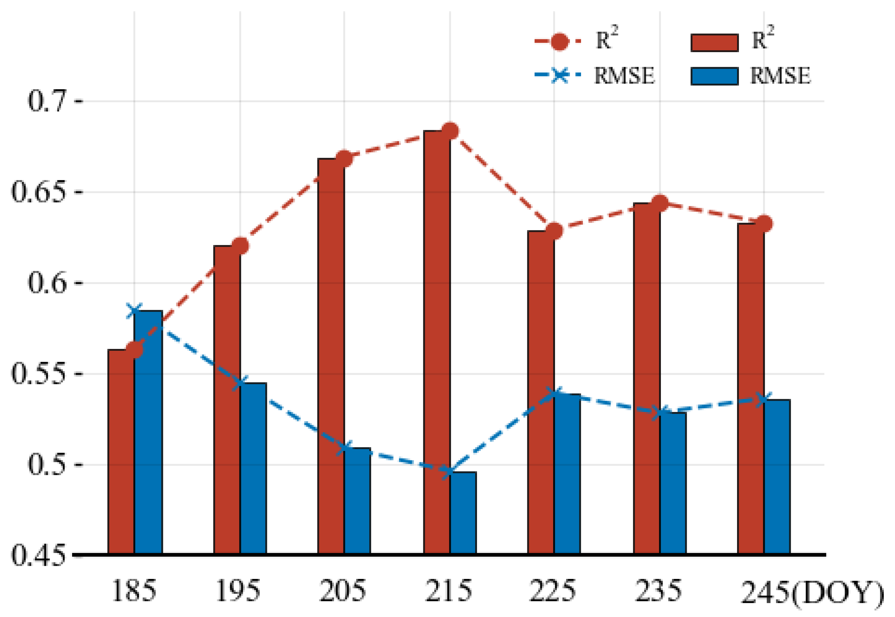
Accurately predicting winter wheat yield before harvest could greatly benefit decision-makers when making management decisions. In this study, we utilized weather forecast (WF) data combined with Sentinel-2 data to establish the deep-learning network and achieved an in-season county-scale wheat yield prediction in China’s main wheat-producing areas. We tested a combination of short-term WF data from the China Meteorological Administration to predict in-season yield at different forecast lengths. The results showed that explicitly incorporating WF data can improve the accuracy in crop yield predictions [Root Mean Square Error (RMSE) = 0.517 t/ha] compared to using only remote sensing data (RMSE = 0.624 t/ha). After comparing a series of WF data with different time series lengths, we found that adding 25 days of WF data can achieve the highest yield prediction accuracy. Specifically, the highest accuracy (RMSE = 0.496 t/ha) is achieved when predictions are made on Day of The Year (DOY) 215 (40 days before harvest). Our study established a deep-learning model which can be used for early yield prediction at the county level, and we have proved that weather forecast data can also be applied in data-driven deep-learning yield prediction tasks.

1. Introduction

Wheat is one of the major staple crops in China, and early yield prediction before harvest is of great significance [1]. At governmental and inter-governmental levels, these forecasts inform decisions related to food security [2,3]. For agricultural industries and processors, accurate yield forecasts enable effective planning for grain storage, transportation, and marketing [4]. Thus, it is imperative to improve the precision and reliability of winter wheat yield prediction at the county scale [5,6].
With the advent of the big data era, remote sensing technology is increasingly being used in the agricultural field, especially showing great potential in crop yield estimation [4,7,8,9]. Traditional remote sensing yield estimation methods primarily include crop models and statistical models. Although crop models based on crop growth processes play a crucial role in simulating crop growth and development, they have limitations due to reliance on various assumptions and uncertain model parameters [10]. Additionally, these models often depend on data that may contain errors or be difficult to obtain [11]. These factors may affect the prediction accuracy and practical application of the model [12], making yield predictions from these models unreliable [13]. Statistical methods primarily establish regression relationships between weather or remote sensing vegetation indices (such as Normalized Difference Vegetation Index (NDVI)/Enhanced Vegetation Index (EVI)) and crop yields [14,15]. However, although statistical methods are computationally simple and easy to apply [16,17,18], the relationship between the index and yield is not simply linear, and traditional statistical methods cannot adequately capture changes in yield [4,19].
In recent years, with the development of machine learning and deep-learning technologies, more and more scholars have begun to try to apply these advanced data analysis methods to yield prediction tasks, such as RF (random forest) [20], SVR (Support Vector Regression) [4], RNN (Recurrent Neural Network) [21], LSTM (Long Short-Term Memory) [9,19,22], CNN (Convolutional Neural Network) [5,23,24], GNN (Graph Neural Network) [21,25,26,27], Transformer [28], and so on. These methods can effectively utilize spatial information from remote sensing images and improve the accuracy and reliability of yield prediction by uncovering underlying patterns in time series data. Furthermore, some studies have explored integrating more information to enhance prediction accuracy through the combination of the above models. For example, some research has employed a combination of RNN/LSTM/GRU and GNN to learn spatiotemporal information simultaneously for yield prediction [25,29]. Fan et al. proposed a novel graph-based framework, GNN-RNN, which integrates geographic space and temporal knowledge into inference to predict yields of major crops in the United States [21]. Qiao et al. introduced a location-aware spatial attention temporal network model, KSTAGE, which aggregates spatial neighborhood features for yield prediction of major crops in Chinese and American counties [27].
The prediction methods based on machine-learning models can be divided into two categories: those based on remote sensing data and those based on meteorological data. The former utilizes hyperspectral, multispectral, or radar imagery [19,30], as well as Sun/Solar-induced Chlorophyll Fluorescence (SIF) [31] and Vegetation Optical Depth (VOD) [32] to estimate crop yields, while the latter uses meteorological parameters, such as temperature, precipitation, vapor pressure, and wind speed, to predict crop yields [33,34,35,36,37,38]. However, the former often overlooks the meteorological factors that directly reflect the crop growth environment, and the latter lacks high-resolution remote sensing data for precise agricultural tracking [24]. Using both remote sensing and meteorological data can complement the strengths of remote sensing technology and crop mechanisms, enabling their application in large-scale crop yield prediction. Previous research has also shown that yield prediction models based on both meteorological data and satellite data outperform models relying on a single data source [15,39].
Weather forecast data have always been an important support for agricultural management [40,41,42]. Combining crop management with weather forecasts allows for real-time and accurate understanding of the interactions between soil, water, and crops [43], thus enabling effective management of water and fertilizer usage, providing the potential to increase yield. With the development of weather prediction models, more and more yield prediction studies have used weather forecast data [34,44,45,46]. For instance, Boa et al. used the latest European Centre for Medium-Range Weather Forecasts (ECMWF) to assess the potential for regional-scale agricultural yield prediction in two different climatic zones, finding that weather forecasts could capture interannual yield differences [45]. However, weather forecast data are more commonly used in yield prediction tasks based on crop models [36,47]. Mostly, wheat yield is typically predicted using only historical remote sensing data or meteorological data up to the prediction date, without incorporating any information related to yield after that date [1,6,19]. The prediction date refers to the earliest date within the winter wheat growing season when yield prediction can be made. For example, Cheng et al. constructed a spatiotemporal deep-learning yield model using historical remote sensing data and historical meteorological data up to the prediction date [6]. Meteorological websites that perform weather prediction release real-time future weather forecast data, which can supplement meteorological information reflecting wheat yield after the prediction date [48]. Therefore, in this study, we combine remote sensing data with weather forecast data for wheat yield prediction.
In this study, we focus on the main winter wheat-producing regions in eight provinces of China to explore how to incorporate weather forecast data into a deep-learning yield prediction model based on remote sensing data. We utilize Sentinel-2 remote sensing data along with collected weather forecast data to construct a deep-learning spatiotemporal yield prediction model called long-short-term memory (LSTM)—graph neural network (GNN)—Yield Prediction (LGYP). This method integrates multiple data sources for yield prediction and, for the first time, incorporates future weather forecast information into a deep-learning yield prediction network. This innovative framework provides a real-time monitoring solution for winter wheat yield.

2. Materials and Methods

2.1. Study Area

Henan, Hebei, Shandong, Jiangsu, Anhui, Shanxi, Shaanxi, and Hubei are the main winter wheat-producing provinces, accounting for 90% of the total winter wheat production in China (Figure 1b). The study areas are geographically divided into northern and southern regions. The northern production areas are mainly located south of the Great Wall and north of the Qinling-Huai River, characterized by a temperate continental monsoon climate. The southern main production areas are located south of the Huai River, characterized by a subtropical monsoon climate. The study areas encompass different crop planting structures, climate types, and management practices [6]. In 2020, these eight provinces produced a total of 118.17 million tons of winter wheat (Figure 1b), covering a planted area of 19.52 million hectares (https://www.stats.gov.cn/ (accessed on 24 March 2024)) (Figure 1a).

2.2. Data

2.2.1. Remote Sensing Data

In this study, the remote sensing data were primarily derived from Sentinel-2A/B (S2) Multi-Spectral Instrument (MSI) top-of-atmosphere (TOA) reflectance images (Level-1C) through Google Earth Engine (GEE). The Sentinel-2 satellite is equipped with a Multi-Spectral Instrument (MSI) with a swath width of up to 290 km and an altitude of 786 km. It can cover 13 spectral bands, with ground resolutions of 10 m, 20 m, and 60 m, respectively. Referring to previous studies [6], four spectral bands were used in this study: the visible green band (Band 7, 773–793 nm), near-infrared band (Band 8, 785–900 nm), red edge band (Band 8A, 855–875 nm), and shortwave infrared band (Band 12, 2100–2280 nm), with spatial resolutions of 10 m, 10 m, 20 m, and 20 m, respectively.
Further, TOA data have been found in other work to provide models with similar accuracy to those based on SR data [49,50,51]. Thus, all accessible Sentinel-2 TOA images from October to June for 2017–2020 were obtained. Another reason for using TOA data in this article is to try to reduce intermediate processing steps and achieve the inversion process from TOA data directly to the inversion target. Winter wheat is typically sown in early October and harvested in mid-June the following year. There are a total of 255 days in the growing season. We use the mean composite method to generate a stable 5-day interval time series, and cropland masking is applied synchronously. The length of the time series for each year is 50, covering the entire growing season of winter wheat (from October to mid-June of the following year).

2.2.2. Weather Forecast Data

To construct the weather forecast database for 2017–2020, we developed a Python-based web crawler program to automatically crawl weather data from the website Weather After Report (http://www.tianqihoubao.com/lishi (accessed on 10 March 2024)). We collected weather conditions, daily minimum and maximum temperatures, and wind directions and forces (for day and night) from 6 October to 16 July during the wheat growing seasons. There are studies indicating that the weather forecast data are reliable. Song et al. analyzed 24-h city-level weather forecasts from the China Meteorological Administration (2000–2015) and compared them with ERA-Interim reanalysis data finding that, in the main winter wheat growing areas of the Huang-Huai-Hai Plain in China, the temperature root mean square error (RMSE) was less than 2° [52]. For ease of analysis, referring to the classification standard for rainfall levels on the China Weather website (https://www.cma.gov.cn/ (accessed on 12 March 2024)), we converted the text descriptions of weather conditions into a set of numerical levels corresponding to precipitation amounts. For example, “cloudy” is calibrated as 0, “light rain” as 10, “moderate rain” as 17, “heavy rain” as 37, and “heavy snow” as 10, etc. (unit: mm). We organized the annually downloaded data into time-series data that aligns with the winter wheat growing season, which means that the data for each year was structured from October of one year to June of the following year. Subsequently, we handled anomalies within the sequences, including null values and extreme outliers, by replacing them with the average of the meteorological data from the preceding and following days. Finally, we matched the collected yield statistical values one-to-one based on the administrative codes of the counties, forming feature-label pairs for model training. We also conducted checks on the processed data.
From 2017 to 2020, we used historical records from weather forecasts to train our yield prediction model from the website Weather After Report. Daily updated weather forecast data for the next 40 days can be obtained from the China Meteorological Administration’s website (http://www.weather.com.cn/ (accessed on 22 March 2024)). When our model is deployed for real-time yield prediction in the future, the weather forecast data can be obtained in real-time from the China Meteorological Administration’s website.

2.2.3. Winter Wheat Yield

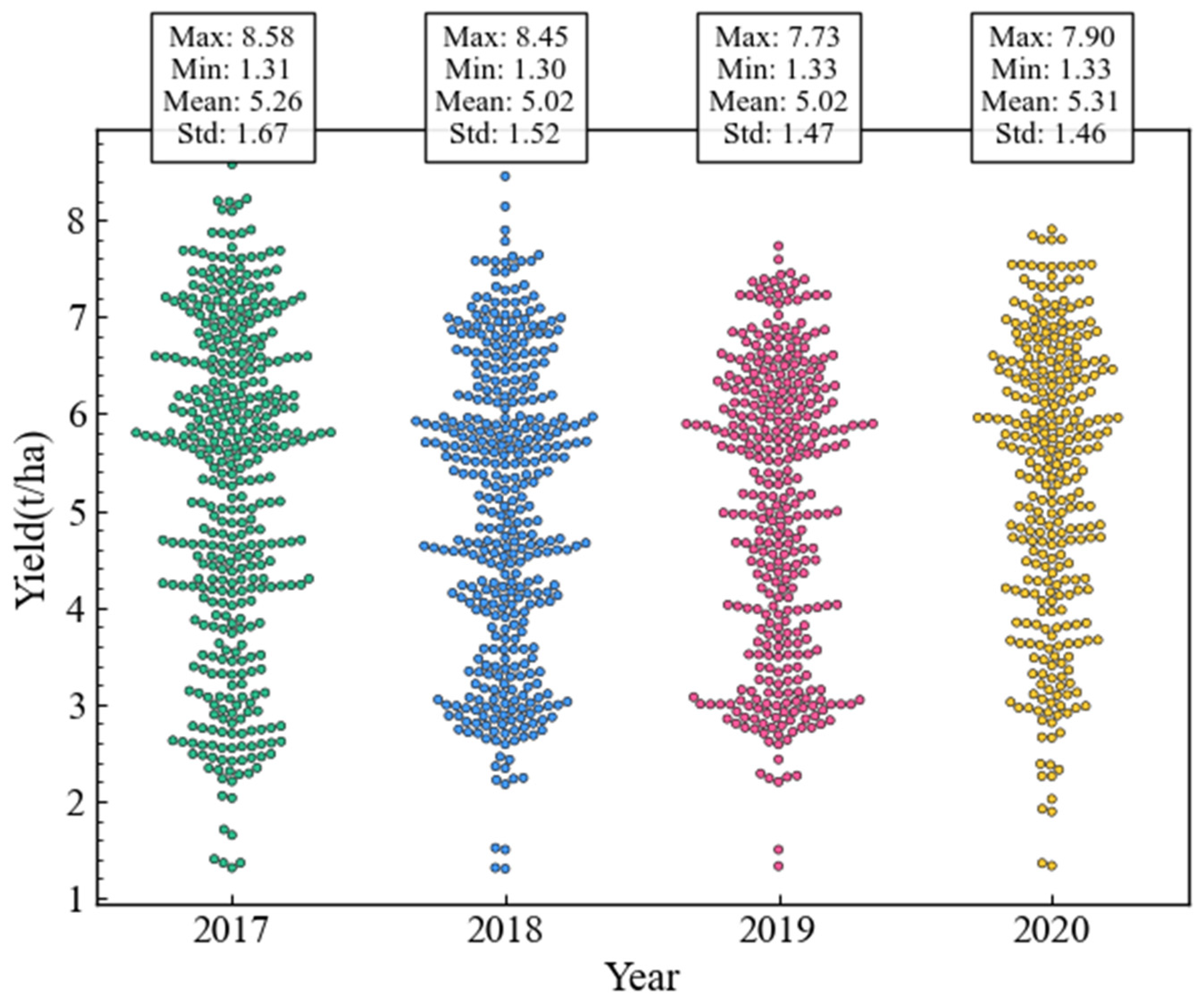
The county-level yield data in 2017–2020 were collected manually from local statistical yearbooks (https://www.stats.gov.cn/sj/zxfb/ (accessed on 24 March 2024)), which were not published online. We collected a total of 2107 unit-area yield data points, with the values ranging from 1.303 to 8.576 t/ha (Figure 1a). There are yield data for four years. In Section 3, we consistently used the data from 2017 to 2019 as the training set and the data from 2020 as the validation set. As shown in the figure below (Figure 2), we plotted the lollipop chart for the yields over four consecutive years and found that the inter-annual changes in yield were minimal.

2.2.4. Wheat Area Data

In many studies, generalized arable land masks have been used as winter wheat masks [53,54], which can lead to reduced accuracy. Here, we used the winter wheat area product data from Hu et al. (Figure 1b), which covers the four years from 2017 to 2020 and has a spatial resolution of 10 m (https://figshare.com/articles/dataset/_b_10m_winter_wheat_harvested_area_and_planted_area_distribution_map_of_China_for_fivr_years_2018-2022_b_/25097684 (accessed on 20 March 2024)). We took the intersection of the winter wheat grid regions extracted for these four years, selecting only the pixels that remained unchanged over all four years as true winter wheat pixels. We then masked the remote sensing data based on these results, thus ensuring that our subsequent results were based on pure winter wheat pixels only.

2.3. Method

2.3.1. Yield Prediction Model

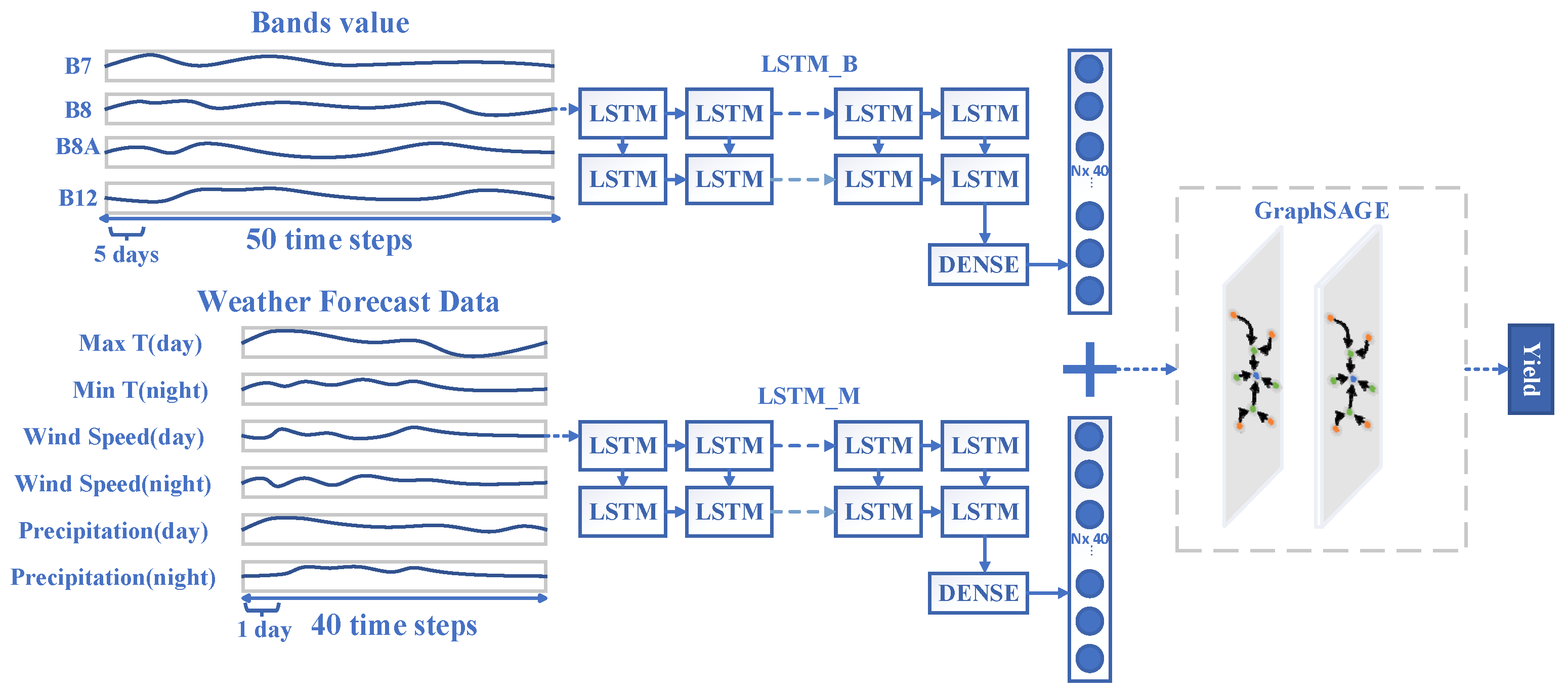
We designed an LGYP (LSTM-GNN-Yield Prediction) network architecture that can simultaneously learn the temporal and spatial information related to yield. This network can learn sequential information from both remote sensing data and daily weather forecast data.
Temporally, a Recurrent Neural Network (RNN) architecture is adopted to learn time-dependent information to incorporate the crop growth process [55]. As shown in the left diagram of Figure 3, here we input five-day mean-composite remote sensing data and daily weather forecasts. Both types of data passed through identical model structures consisting of two layers of LSTM networks, one with 128 neurons followed by another with 256 neurons, subsequently passing through a linear layer, ReLu activation function and finally passing another linear layer. There are two channels in the LSTM model, hence it is called T-LSTM. One reason for this is that remote sensing data and weather record data represent two distinct types of features, and another reason is the asynchronous processing of the two data types in terms of time. We averaged the 255 days of remote sensing data into five-day intervals, reducing the time steps to 50. This step was taken because LSTMs are less effective at learning very long sequences. Learnable aggregation of the long series into shorter sequences facilitated feature learning over long temporal ranges in sequence processing tasks [56]. Similar to Lin et al., who used a Transformer to aggregate a week’s worth of remote sensing sequences before inputting them into an LSTM, we aimed to avoid the low precision issues associated with using LSTMs to learn daily long sequences [28]. In contrast, weather forecast data have a maximum prediction record of 40 days, so we used daily weather forecast records. Given the differing time intervals between the two types of data, we input each type separately into the LSTM model and concatenated the results from the last time step before passing them through a fully connected layer to connect with the GNN module.
Spatially, the relationships are then learned through the GraphSAGE module. Graph Neural Networks (GNNs) are a novel type of neural network designed to uncover complex dependencies inherent in graph-structured data sources [57]. They allow greater flexibility and a wider representation space for embedding node and edge information in the graph for reasoning. GraphSAGE is an important framework in graph neural networks. It utilizes node feature information and learns node embeddings by aggregating from the neighborhoods of nodes [58]. GraphSAGE is suitable for crop yield prediction because most counties only border a few others, making the adjacency matrix sparse [21]. Therefore, after extracting the temporal information with LSTM, we added two layers of GraphSAGE to further extract neighborhood spatial information, achieving aggregation of information across both the temporal and spatial dimensions. Both layers use the “mean” aggregation method, and the dropout value is set to 0.1. To ensure that the yield data for each year are trained on the same graph, we need to fix the number of county yield nodes. However, the missing yield data in the statistical yearbooks are random each year. Thus, we used the union of county yields across the four years to construct the graph and fill in missing data with the average yield of surrounding counties, ensuring alignment of the yield data for each year. During the computation of the loss, we only used the data with real yield labels. The models were trained on PyTorch version 3.8, and GraphSAGE was implemented using the DGL library. All deep-learning models were trained using the Adam optimizer. Models were trained for 200 to 300 epochs until the validation loss stopped decreasing within several epochs. We chose the epoch and hyperparameter settings that produced the lowest Root Mean Squared Error (RMSE) on the validation set.
Compared to GNN-RNN [21], we used LSTM instead of CNN for feature embedding and incorporated remote sensing time series data. Unlike KSTAGE [27], which uses a temporal attention mechanism, we employed dual-channel LSTMs to learn time series data because, in addition to remote sensing data, our paper also includes weather forecast data. The use of a dual-channel recurrent neural network allows for the learning of two different types of features.

2.3.2. Experiment Design

To explore the impact of incorporating weather forecast data on yield prediction, we conducted three sets of experiments to evaluate the impact of different data sources on the accuracy of crop yield prediction. In the first set of experiments, only remote sensing data were used. In the second set of experiments, only weather forecast data were used. The third set of experiments combined remote sensing data and weather forecast data. The weather forecast data included daily information for 40 days following the prediction date. In all experiments, we maintained the same model parameter settings to ensure the comparability of the results.
The second group of experiments was designed to answer the question as to how the length of weather forecasts affects the accuracy of yield predictions. We fixed the use of historical remote sensing data up to DOY215 (with the first day of wheat sowing considered as the start of the growing season on October 6) and explored how the inclusion of weather forecast data of varying lengths (40, 35, 30, 25, 20, 15, 10, 5 days) affects the model’s prediction accuracy.
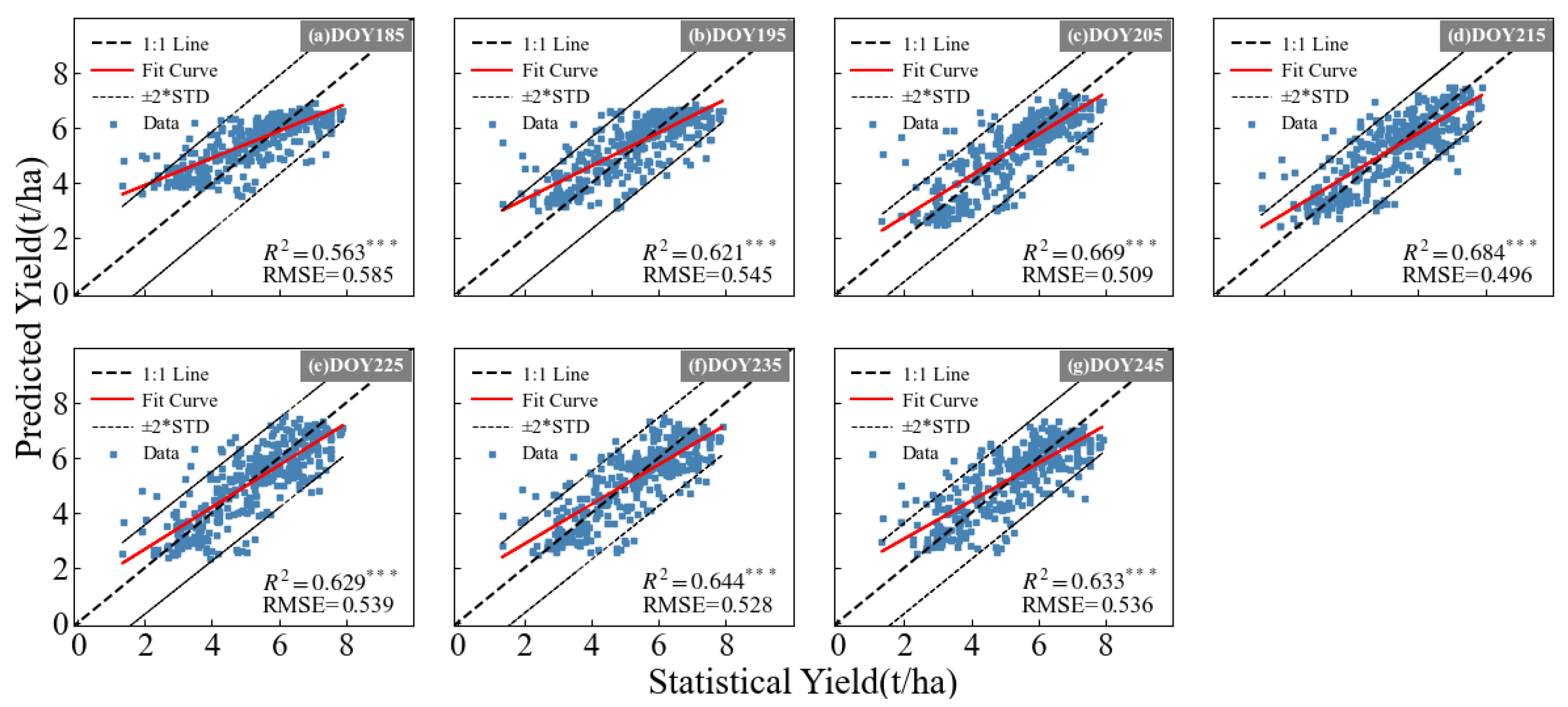
The last group of experiments was designed to answer the question as to how the variation pattern of yield prediction accuracy changes with the progression of the time series. In this experiment, we aimed to determine the earliest time at which yield prediction can be achieved using the LGYP yield prediction model. The winter wheat growing season spans 255 days, from sowing to harvest. We conducted seven sets of experiments, using remote sensing data for up to seven different prediction dates (DOY185, DOY195, DOY205, DOY215, DOY225, DOY235, DOY245), with 25 days of daily weather forecast data following each prediction date. DOY235 and DOY245 used 20 and 10 days of weather forecast data, respectively.
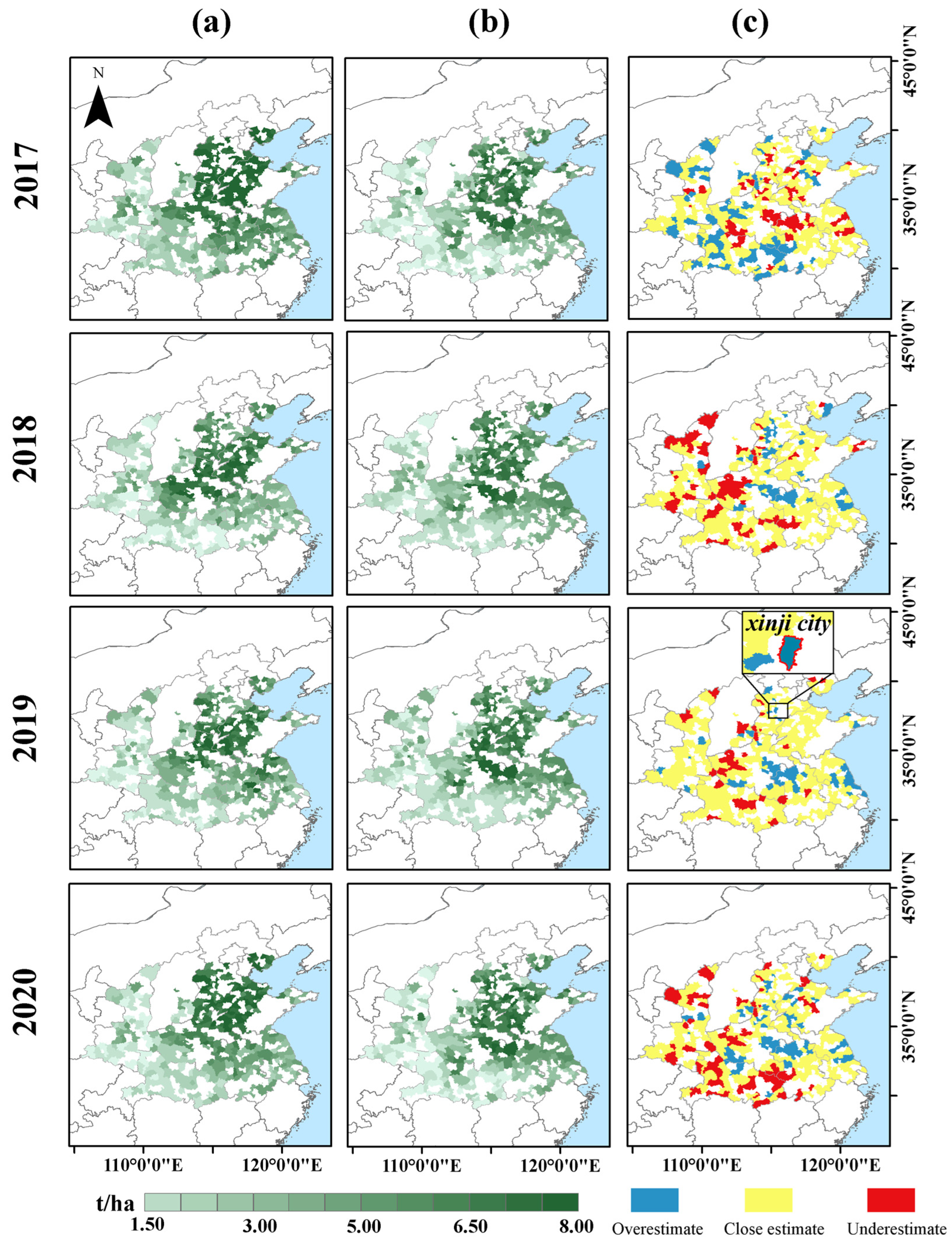
Finally, to more clearly express the overestimation and underestimation of yield in spatial terms, we plot the spatial prediction results from 2016 to 2020. Counties, where the difference between the predicted result and the statistical value is within 1 ton/hectare are set as close estimate, where the predicted yield values that are more than 1 t/ha higher than the true values are considered overestimations, and where the predicted yield values that are more than 1 t/ha lower than the true values are considered underestimations.

2.3.3. Model Evaluation Metrics

To provide a comprehensive evaluation of the experimental results, we used two metrics: the Root Mean Square Error (RMSE) and the Coefficient of Determination (R2). The optimal model has the highest R2 and the lowest RMSE.
R M S E X , h = 1 m i = 1 m h x i y i 2
R 2 X , h = 1 i h x i y i 2 i y i ¯ y i 2
where yi represents the true value of the yield; h(xi) represents the predicted value of the yield estimated by the model; m is the number of samples; and y i ¯ represents the mean of the observed yields.

3. Results

3.1. The Impact of Incorporating Weather Forecast Data on Yield Prediction

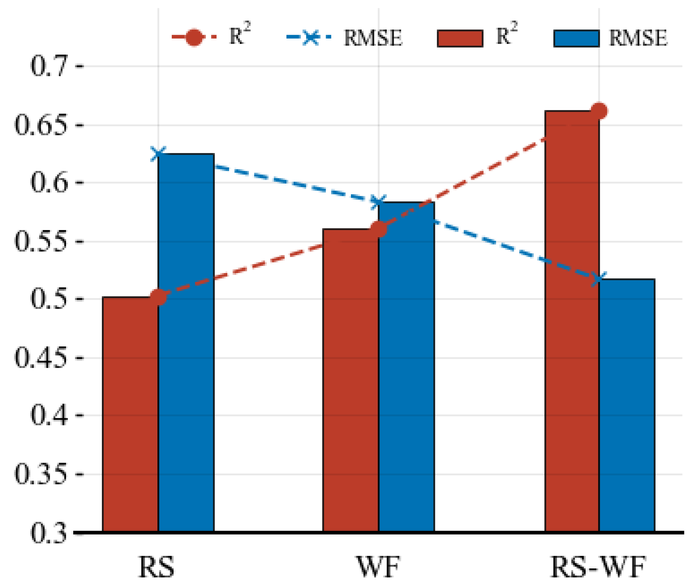
The experimental results showed that, when combining remote sensing data with weather forecast data, the prediction accuracy improved by 16% compared to using only remote sensing data, and by 10% compared to using only weather forecast data (Figure 4). Furthermore, as shown in Figure 5, the prediction results using only weather forecast data outperformed those using only remote sensing data. In conclusion, in addition to the conventionally used satellite historical data, the weather forecast data after the forecast date can also provide forward-looking information for crop yield prediction and help improve the model’s prediction accuracy. This indicates that integrating weather forecast data into the crop yield prediction model can compensate for the limitations of historical data and enhance the model’s adaptability to changes in future weather conditions, thereby improving the overall prediction effect. Therefore, combining weather forecast data with remote sensing data is an effective method that can significantly improve the accuracy of crop yield prediction.

3.2. Determining the Impact of Weather Forecast Length on LGYP Yield Prediction Accuracy

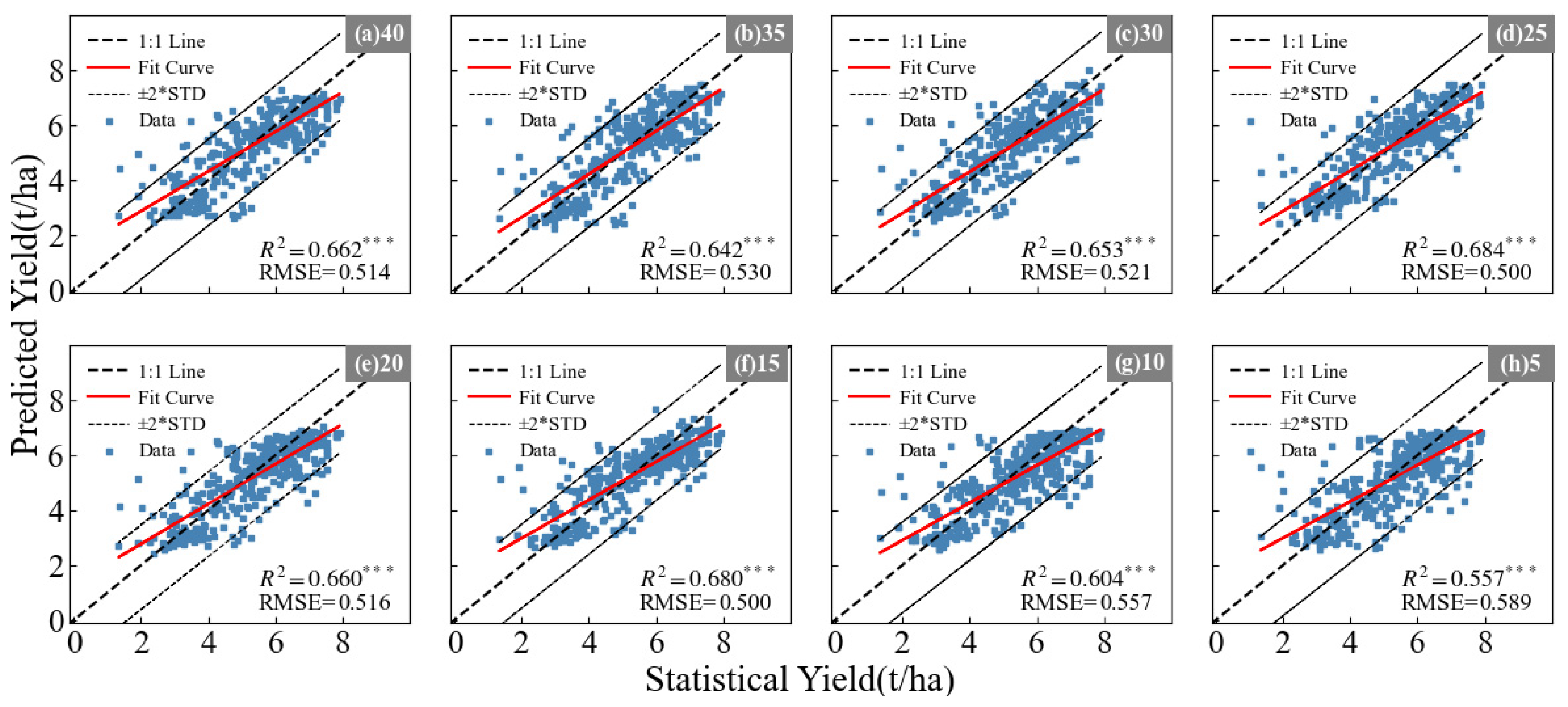
Figure 6 shows a series of scatter plots comparing the differences in prediction accuracy under different lengths of weather forecast data. Each subplot corresponds to a different forecast length, with (a) to (h) representing the addition of 40, 35, 30, 25, 20, 15, 10, and 5 days of weather forecast data, respectively. When adding different lengths’ weather forecast data, the scatter-fitting results are also different. As shown in Figure 7, it is clear that the best performance is achieved when 25 days of weather forecast data are added, i.e., using remote sensing data up to DOY215 plus 25 days of daily weather forecast data after the prediction date. This leads to the highest R2 and the lowest RMSE, indicating that the accuracy improves with the addition of more data, confirming that yield-related features are distributed throughout the wheat growing season up to DOY215. Kaitlin et al. [47] found that the accuracy of in-season crop yield forecasts is inversely proportional to the forecast length (p = 0.026) at four different forecast lengths (14 days, 7 days, 3 days, 0 days). This finding is not consistent with our results, possibly because Kaitlin et al. [47] used a crop model with limited ability to learn useful information from future forecast data. In contrast, our LGYP model includes an LSTM module, which is capable of retaining useful information and filtering out noise. As the length of the weather forecast sequence increases, the range of accuracy decreases, likely due to the unreliability of the weather forecast data. Adding 25 days of weather forecast data leads to the highest yield prediction accuracy.

3.3. The Variation Pattern of Yield Prediction Accuracy with the Progression of the Time Series

The model’s prediction performance differed at different prediction dates, achieving the highest R2 and the lowest RMSE at DOY215 (Figure 8). As shown in Figure 9, the prediction accuracy changed over time. Before DOY215, as the prediction date approached the harvest date, the yield prediction accuracy increased. This is likely due to the incorporation of more information, forming a more complete time series, allowing the model to learn more about the yield from the data sequence. However, after DOY215, the inclusion of more sequence information led to a decrease in accuracy. Our experimental results indicate that using remote sensing data up to 40 days before harvest and 25 days of future weather forecast data to establish a yield prediction model is optimal.

4. Discussion

4.1. The Reason for the Impact on the Results When Incorporating Weather Forecast Data

In this section, we primarily address the question: why does incorporating weather forecast data into the model affect the results, and even perform better than remote sensing data? Our results show that remote sensing data do not perform sufficiently well in the yield prediction task. The possible reason could be that wheat grain formation occurs within a husk, which is not visible to optical satellites [22]. The contribution of satellite information for yield prediction decreases in the late growing season [22]. At the same time, since grain formation is influenced by climate changes, particularly sensitive to drought and high temperatures, weather data provide a more accurate indication of wheat yield levels [59]. Xiong et al. also demonstrated that daily inputs can provide detailed information about environmental factors, including dynamic changes in environmental stress and the temporal response of crop yield to these factors [28]. Therefore, climate information has a greater predictive impact on yield than satellite information, which is consistent with the findings in [22]. Moreover, it is evident that the combination of remote sensing and weather forecast data achieves the highest R2 and the lowest RMSE, indicating that the complementary information provided by remote sensing data and weather forecast data results in the best model predictions. Kaitlin et al. [47] showed that incorporating weather forecasts can reduce the uncertainty in crop yield predictions, providing more reliable estimates compared to using only historical data, which aligns with our conclusions.

4.2. The Reason for the Variation in Yield Prediction Accuracy with the Progression of the Time Series

In Figure 9, the model’s prediction performance differed at different prediction dates, achieving the highest R2 and the lowest RMSE at DOY215. This is consistent with previous research [6,22], indicating that the distribution of yield-related feature information from remote sensing data across the entire growing season is not uniform, and there is less relevant information in the later stages. Many studies have shown that adding data from the later stages of winter wheat growth does not necessarily bring significant improvements in accuracy and may even lead to a decrease in accuracy. Therefore, it can be determined that it is possible to make yield predictions in advance of harvest [6,19,60,61]. Cai et al. used climate and remote sensing data to forecast wheat yield in Australia, and achieved the optimal prediction performance (R2 = 0.73) with a two-month lead time before harvest.
Although the forget and input gate mechanisms in LSTM models can update useful information [62], they perform less effectively in capturing long sequences compared to Transformers [28]. Qiao et al. [27] demonstrated that replacing LSTM with multi-head attention mechanisms has advantages in simulating time-related correlations during the crop growth period. Therefore, a potential next step is to replace the dual-channel LSTM model with a Transformer [63] or Informer [64], which performs better in learning from multimodal data, to see if this further improves the model’s performance.

4.3. The Spatial Distribution Pattern of Yield Prediction Results

As shown in Figure 10, we plot the spatial prediction results from 2016 to 2020. As can be seen in Figure 10c, in 2019, most counties are marked as close estimate, and the model prediction effect is the best. In 2017, there are relatively many counties marked as overestimate, meaning that there are more counties where the yield is overestimated; in 2018 and 2020, there are relatively many counties marked as underestimates, meaning that there are more counties where the yield is underestimated (as shown in Figure 10c).
Overestimation or underestimation of yield may be related to natural disasters that occurred in that year. For example, in 2019, Xinji City was hit by dry and hot winds, resulting in a predicted yield higher than the actual yield [65]. In the marked place in Figure 10c, it can also be seen that the yield of Xinji City was overestimated in 2019. Studies have shown that the current open source meteorological data are far from representing natural disasters, which limits the consideration of the impact of disasters by our deep–learning model [5]. Our model cannot sensitively predict natural disaster events through data indicators in weather forecasts. This may also be caused by improper handling of extreme values in the data processing process. In addition, the underestimation of yield by the model is also related to the yield-increasing measures taken by farmers under unfavorable weather conditions. These measures are not considered by the model in the prediction process [46].

4.4. Limitations of Weather Forecast Data

The longer the weather forecast sequence, the greater the potential unreliability of the prediction data. Therefore, when using longer sequences of data as input to the yield prediction model, the performance might deteriorate (Figure 7). Our experiments show that adding 25 days of data leads to better results than adding 30, 35, or 40 days. This is consistent with the findings of Chen et al., who used different weather prediction datasets (CMA/ECMWF/UKMO) and found that the accuracy of winter wheat yield prediction decreased as the length of the weather forecast data increased in the later stages [36]. We also attempted to include weather forecast data before the prediction date, but using the full daily meteorological data sequence throughout the growing season worsened the results.
Although the accuracy of weather forecasts has improved with technological advancements, there is still some discrepancy with actual weather conditions [48]. This discrepancy may be the primary limitation in providing effective information from weather data in our model. The quality of weather forecasts can significantly affect forecasting skills since the crop model is driven solely by weather forecasts after the prediction date [36]. The improvement in weather forecasts should be expected to improve yield forecasting. Additionally, it is crucial to enhance the ability to predict extreme weather conditions, as this is vital for agricultural management and yield forecasting [66].

5. Conclusions

Forecasting winter wheat production in season is becoming increasingly important for agricultural producers to make informed crop management and financial decisions. This study presented a case study for evaluating the potential of daily weather forecasts. Our approach has made contributions both methodologically and in terms of results, further enhancing the capability to incorporate weather forecast data into deep-learning models for in-season crop yield prediction. The most important results are:
(1)
The combination of remote sensing and weather forecast data improves prediction accuracy by 16% compared to using remote sensing data alone.
(2)
Within a range of 0–40 days, selecting weather forecast data for 25 days leads to better performance.
(3)
County-scale wheat yield predictions in China can be made 40 days before wheat harvest, achieving the highest level of accuracy (RMSE = 0.496 t/ha).

Author Contributions

Conceptualization, D.P., E.C. and X.F.; methodology, D.P., E.C. and X.F.; software, B.Z. (Bing Zhang); validation, J.H., Z.L., H.Z., Y.L. and H.P.; formal analysis, D.P. and E.C.; investigation, D.P.; resources, D.P.; data curation, D.P., E.C. and B.Z. (Bing Zhang); writing—original draft preparation, D.P. and E.C.; writing—review and editing, D.P. and X.F.; visualization, D.P. and E.C.; supervision, D.P. and E.C; project administration, D.P. and B.Z. (Bin Zhao); funding acquisition, D.P. and B.Z. (Bing Zhang); All authors have read and agreed to the published version of the manuscript.

Funding

This research was funded by the National Natural Science Foundation of China (grant number 42030111, 42471372) and the Science and Disruptive Technology Program, AIRCAS (grant number E2Z218020F).

Data Availability Statement

The data presented in this study are available on request from the corresponding author. The data are not publicly available due to privacy.

Conflicts of Interest

The authors declare no conflicts of interest.

References

  1. Tian, H.; Wang, P.; Tansey, K.; Zhang, J.; Zhang, S.; Li, H. An LSTM Neural Network for Improving Wheat Yield Estimates by Integrating Remote Sensing Data and Meteorological Data in the Guanzhong Plain, PR China. Agric. For. Meteorol. 2021, 310, 108629. [Google Scholar] [CrossRef]
  2. Meroni, M.; Waldner, F.; Seguini, L.; Kerdiles, H.; Rembold, F. Yield Forecasting with Machine Learning and Small Data: What Gains for Grains? Agric. For. Meteorol. 2021, 308–309, 108555. [Google Scholar] [CrossRef]
  3. Terliksiz, A.S.; Altilar, D.T. Impact of Large Kernel Size on Yield Prediction: A Case Study of Corn Yield Prediction with SEDLA in the U.S. Corn Belt. Environ. Res. Commun. 2024, 6, 025011. [Google Scholar] [CrossRef]
  4. Cheng, E.; Zhang, B.; Peng, D.; Zhong, L.; Yu, L.; Liu, Y.; Xiao, C.; Li, C.; Li, X.; Chen, Y.; et al. Wheat Yield Estimation Using Remote Sensing Data Based on Machine Learning Approaches. Front. Plant Sci. 2022, 13, 1090970. [Google Scholar] [CrossRef] [PubMed]
  5. Li, X.; Geng, H.; Zhang, L.; Peng, S.; Xin, Q.; Huang, J.; Li, X.; Liu, S.; Wang, Y. Improving Maize Yield Prediction at the County Level from 2002 to 2015 in China Using a Novel Deep Learning Approach. Comput. Electron. Agric. 2022, 202, 107356. [Google Scholar] [CrossRef]
  6. Cheng, E.; Wang, F.; Peng, D.; Zhang, B.; Zhao, B.; Zhang, W.; Hu, J.; Lou, Z.; Yang, S.; Zhang, H.; et al. A GT-LSTM Spatio-Temporal Approach for Winter Wheat Yield Prediction: From the Field Scale to County Scale. IEEE Trans. Geosci. Remote Sens. 2024, 62, 1–18. [Google Scholar] [CrossRef]
  7. Tian, H.; Wang, P.; Tansey, K.; Han, D.; Zhang, J.; Zhang, S.; Li, H. A Deep Learning Framework under Attention Mechanism for Wheat Yield Estimation Using Remotely Sensed Indices in the Guanzhong Plain, PR China. Int. J. Appl. Earth Obs. Geoinf. 2021, 102, 102375. [Google Scholar] [CrossRef]
  8. Yu, R.; Li, S.; Zhang, B.; Zhang, H. A Deep Transfer Learning Method for Estimating Fractional Vegetation Cover of Sentinel-2 Multispectral Images. IEEE Geosci. Remote Sens. Lett. 2022, 19, 1–5. [Google Scholar] [CrossRef]
  9. Lin, T.; Zhong, R.; Wang, Y.; Xu, J.; Jiang, H.; Xu, J.; Ying, Y.; Rodriguez, L.; Ting, K.C.; Li, H. DeepCropNet: A Deep Spatial-Temporal Learning Framework for County-Level Corn Yield Estimation. Environ. Res. Lett. 2020, 15, 034016. [Google Scholar] [CrossRef]
  10. Nandram, B.; Berg, E.; Barboza, W. A Hierarchical Bayesian Model for Forecasting State-Level Corn Yield. Env. Ecol. Stat. 2014, 21, 507–530. [Google Scholar] [CrossRef]
  11. Heslot, N.; Akdemir, D.; Sorrells, M.E.; Jannink, J.-L. Integrating Environmental Covariates and Crop Modeling into the Genomic Selection Framework to Predict Genotype by Environment Interactions. Theor. Appl. Genet. 2014, 127, 463–480. [Google Scholar] [CrossRef] [PubMed]
  12. Dokoohaki, H.; Kivi, M.S.; Martinez-Feria, R.; Miguez, F.E.; Hoogenboom, G. A Comprehensive Uncertainty Quantification of Large-Scale Process-Based Crop Modeling Frameworks. Environ. Res. Lett. 2021, 16, 084010. [Google Scholar] [CrossRef]
  13. Chandar, A.G.; Sivasankari, K.; Lakshmi, S.L.; Sugumaran, S.; Kannadhasan, S.; Balakumar, S. An Innovative Smart Agriculture System Utilizing a Deep Neural Network and Embedded System to Enhance Crop Yield. Multidiscip. Sci. J. 2023, 6, 2024063. [Google Scholar] [CrossRef]
  14. Kern, A.; Barcza, Z.; Marjanović, H.; Árendás, T.; Fodor, N.; Bónis, P.; Bognár, P.; Lichtenberger, J. Statistical Modelling of Crop Yield in Central Europe Using Climate Data and Remote Sensing Vegetation Indices. Agric. For. Meteorol. 2018, 260–261, 300–320. [Google Scholar] [CrossRef]
  15. Franch, B.; Vermote, E.F.; Becker-Reshef, I.; Claverie, M.; Huang, J.; Zhang, J.; Justice, C.; Sobrino, J.A. Improving the Timeliness of Winter Wheat Production Forecast in the United States of America, Ukraine and China Using MODIS Data and NCAR Growing Degree Day Information. Remote Sens. Environ. 2015, 161, 131–148. [Google Scholar] [CrossRef]
  16. Mathieu, J.A.; Aires, F. Assessment of the Agro-Climatic Indices to Improve Crop Yield Forecasting. Agric. For. Meteorol. 2018, 253–254, 15–30. [Google Scholar] [CrossRef]
  17. Iizumi, T.; Shiogama, H.; Imada, Y.; Hanasaki, N.; Takikawa, H.; Nishimori, M. Crop Production Losses Associated with Anthropogenic Climate Change for 1981–2010 Compared with Preindustrial Levels. Int. J. Climatol. 2018, 38, 5405–5417. [Google Scholar] [CrossRef]
  18. Fritz, S.; See, L.; Bayas, J.C.L.; Waldner, F.; Jacques, D.; Becker-Reshef, I.; Whitcraft, A.; Baruth, B.; Bonifacio, R.; Crutchfield, J.; et al. A Comparison of Global Agricultural Monitoring Systems and Current Gaps. Agric. Syst. 2019, 168, 258–272. [Google Scholar] [CrossRef]
  19. Zhang, L.; Zhang, Z.; Luo, Y.; Cao, J.; Xie, R.; Li, S. Integrating Satellite-Derived Climatic and Vegetation Indices to Predict Smallholder Maize Yield Using Deep Learning. Agric. For. Meteorol. 2021, 311, 108666. [Google Scholar] [CrossRef]
  20. Choudhary, K.; Shi, W.; Dong, Y.; Paringer, R. Random Forest for Rice Yield Mapping and Prediction Using Sentinel-2 Data with Google Earth Engine. Adv. Space Res. 2022, 70, 2443–2457. [Google Scholar] [CrossRef]
  21. Fan, J.; Bai, J.; Li, Z.; Ortiz-Bobea, A.; Gomes, C.P. A GNN-RNN Approach for Harnessing Geospatial and Temporal Information: Application to Crop Yield Prediction 2022. In Proceedings of the Thirty-Sixth AAAI Conference on Artificial Intelligence, Virtually, 22 February 22–1 March 2022. [Google Scholar]
  22. Cai, Y.; Guan, K.; Lobell, D.; Potgieter, A.B.; Wang, S.; Peng, J.; Xu, T.; Asseng, S.; Zhang, Y.; You, L.; et al. Integrating Satellite and Climate Data to Predict Wheat Yield in Australia Using Machine Learning Approaches. Agric. For. Meteorol. 2019, 274, 144–159. [Google Scholar] [CrossRef]
  23. Zhang, C.; Diao, C. A Phenology-Guided Bayesian-CNN (PB-CNN) Framework for Soybean Yield Estimation and Uncertainty Analysis. ISPRS J. Photogramm. Remote Sens. 2023, 205, 50–73. [Google Scholar] [CrossRef]
  24. Lin, F.; Crawford, S.; Guillot, K.; Zhang, Y.; Chen, Y.; Yuan, X.; Chen, L.; Williams, S.; Minvielle, R.; Xiao, X.; et al. MMST-ViT: Climate Change-Aware Crop Yield Prediction via Multi-Modal Spatial-Temporal Vision Transformer. In Proceedings of the 2023 IEEE/CVF International Conference on Computer Vision (ICCV), Paris, France, 1–6 October 2023. [Google Scholar]
  25. Han, D.; Wang, P.; Tansey, K.; Zhang, Y.; Li, H. A Graph-Based Deep Learning Framework for Field Scale Wheat Yield Estimation. Int. J. Appl. Earth Obs. Geoinf. 2024, 129, 103834. [Google Scholar] [CrossRef]
  26. Yang, F.; Zhang, D.; Zhang, Y.; Zhang, Y.; Han, Y.; Zhang, Q.; Zhang, Q.; Zhang, C.; Liu, Z.; Wang, K. Prediction of Corn Variety Yield with Attribute-Missing Data via Graph Neural Network. Comput. Electron. Agric. 2023, 211, 108046. [Google Scholar] [CrossRef]
  27. Qiao, M.; He, X.; Cheng, X.; Li, P.; Zhao, Q.; Zhao, C.; Tian, Z. KSTAGE: A Knowledge-Guided Spatial-Temporal Attention Graph Learning Network for Crop Yield Prediction. Inf. Sci. 2023, 619, 19–37. [Google Scholar] [CrossRef]
  28. Xiong, X.; Zhong, R.; Tian, Q.; Huang, J.; Zhu, L.; Yang, Y.; Lin, T. Daily DeepCropNet: A Hierarchical Deep Learning Approach with Daily Time Series of Vegetation Indices and Climatic Variables for Corn Yield Estimation. ISPRS J. Photogramm. Remote Sens. 2024, 209, 249–264. [Google Scholar] [CrossRef]
  29. Xu, S.; Zhou, Y.; Yu, X.; Huang, C.; Wu, C. TFSF: Topological and Feature Space Fusion with Spatio-Temporal Modeling for Crop Yield Prediction. In Proceedings of the 2023 26th International Conference on Computer Supported Cooperative Work in Design (CSCWD), Rio de Janeiro, Brazil, 24–26 May 2023. [Google Scholar]
  30. Marshall, M.; Belgiu, M.; Boschetti, M.; Pepe, M.; Stein, A.; Nelson, A. Field-Level Crop Yield Estimation with PRISMA and Sentinel-2. ISPRS J. Photogramm. Remote Sens. 2022, 187, 191–210. [Google Scholar] [CrossRef]
  31. Zhu, J. The Relationship between Wheat Yield and Sun-Induced Chlorophyll Fluorescence from Continuous Measurements over the Growing Season. Remote Sens. Environ. 2023, 298, 113791. [Google Scholar] [CrossRef]
  32. Mateo-Sanchis, A.; Piles, M.; Muñoz-Marí, J.; Adsuara, J.E.; Pérez-Suay, A.; Camps-Valls, G. Synergistic Integration of Optical and Microwave Satellite Data for Crop Yield Estimation. Remote Sens. Environ. 2019, 234, 111460. [Google Scholar] [CrossRef]
  33. Quiring, S.M.; Legates, D.R. Application of CERES-Maize for within-Season Prediction of Rainfed Corn Yields in Delaware, USA. Agric. For. Meteorol. 2008, 148, 964–975. [Google Scholar] [CrossRef]
  34. Wanthanaporn, U.; Supit, I.; Chaowiwat, W.; Hutjes, R.W.A. Skill of Rice Yields Forecasting over Mainland Southeast Asia Using the ECMWF SEAS5 Ensemble Prediction System and the WOFOST Crop Model. Agric. For. Meteorol. 2024, 351, 110001. [Google Scholar] [CrossRef]
  35. De Wit, A.; Baruth, B.; Boogaard, H.; Van Diepen, K.; Van Kraalingen, D.; Micale, F.; Te Roller, J.; Supit, I.; Van Den Wijngaart, R. Using ERA-INTERIM for Regional Crop Yield Forecasting in Europe. Clim. Res. 2010, 44, 41–53. [Google Scholar] [CrossRef]
  36. Chen, Y.; Tao, F. Potential of Remote Sensing Data-Crop Model Assimilation and Seasonal Weather Forecasts for Early-Season Crop Yield Forecasting over a Large Area. Field Crops Res. 2022, 276, 108398. [Google Scholar] [CrossRef]
  37. Kirthiga, S.M.; Patel, N.R. In-Season Wheat Yield Forecasting at High Resolution Using Regional Climate Model and Crop Model. AgriEngineering 2022, 4, 1054–1075. [Google Scholar] [CrossRef]
  38. Zare, H.; Viswanathan, M.; Weber, T.K.; Ingwersen, J.; Nowak, W.; Gayler, S.; Streck, T. Improving Winter Wheat Yield Prediction by Accounting for Weather and Model Parameter Uncertainty While Assimilating LAI and Updating Weather Data within a Crop Model. Eur. J. Agron. 2024, 156, 127149. [Google Scholar] [CrossRef]
  39. Newlands, N.K. An Integrated, Probabilistic Model for Improved Seasonal Forecasting of Agricultural Crop Yield under Environmental Uncertainty. Front. Environ. Sci. 2014, 2, 17. [Google Scholar] [CrossRef]
  40. Chakraborty, D.; Saha, S.; Sethy, B.K.; Singh, H.D.; Singh, N.; Sharma, R.; Chanu, A.N.; Walling, I.; Anal, P.R.; Chowdhury, S.; et al. Usability of the Weather Forecast for Tackling Climatic Variability and Its Effect on Maize Crop Yield in Northeastern Hill Region of India. Agronomy 2022, 12, 2529. [Google Scholar] [CrossRef]
  41. Pujahari, R.M.; Yadav, S.P.; Khan, R. Intelligent Farming System through Weather Forecast Support and Crop Production. In Application of Machine Learning in Agriculture; Elsevier: Amsterdam, The Netherlands, 2022; pp. 113–130. ISBN 978-0-323-90550-3. [Google Scholar]
  42. Raimundo, F.; Glória, A.; Sebastião, P. Prediction of Weather Forecast for Smart Agriculture Supported by Machine Learning. In Proceedings of the 2021 IEEE World AI IoT Congress (AIIoT), Seattle, WA, USA, 10–13 May 2021; pp. 0160–0164. [Google Scholar]
  43. Anupoju, V.; Kambhammettu, B.P.; Regonda, S.K. Role of Short-Term Weather Forecast Horizon in Irrigation Scheduling and Crop Water Productivity of Rice. J. Water Resour. Plan. Manag. 2021, 147, 05021009. [Google Scholar] [CrossRef]
  44. Brinkhoff, J.; Clarke, A.; Dunn, B.W.; Groat, M. Analysis and Forecasting of Australian Rice Yield Using Phenology-Based Aggregation of Satellite and Weather Data. Agric. For. Meteorol. 2024, 353, 110055. [Google Scholar] [CrossRef]
  45. Boas, T.; Bogena, H.R.; Ryu, D.; Vereecken, H.; Western, A.; Hendricks Franssen, H.-J. Seasonal Soil Moisture and Crop Yield Prediction with Fifth-Generation Seasonal Forecasting System (SEAS5) Long-Range Meteorological Forecasts in a Land Surface Modelling Approach. Hydrol. Earth Syst. Sci. 2023, 27, 3143–3167. [Google Scholar] [CrossRef]
  46. Thimmegowda, M.N.; Manjunatha, M.H.; Huggi, L.; Shivaramu, H.S.; Soumya, D.V.; Nagesha, L.; Padmashri, H.S. Weather-Based Statistical and Neural Network Tools for Forecasting Rice Yields in Major Growing Districts of Karnataka. Agronomy 2023, 13, 704. [Google Scholar] [CrossRef]
  47. Togliatti, K.; Archontoulis, S.V.; Dietzel, R.; Puntel, L.; VanLoocke, A. How Does Inclusion of Weather Forecasting Impact In-Season Crop Model Predictions? Field Crop. Res. 2017, 214, 261–272. [Google Scholar] [CrossRef]
  48. Pan, B.; Anderson, G.J.; Goncalves, A.; Lucas, D.D.; Bonfils, C.J.W.; Lee, J. Improving Seasonal Forecast Using Probabilistic Deep Learning. J. Adv. Model Earth Syst. 2022, 14, e2021MS002766. [Google Scholar] [CrossRef]
  49. Song, C.; Woodcock, C.E.; Seto, K.C.; Lenney, M.P.; Macomber, S.A. Classification and Change Detection Using Landsat TM Data: When and How to Correct Atmospheric Effects? Remote Sens. Environ. 2001, 75, 230–244. [Google Scholar] [CrossRef]
  50. You, N.; Dong, J.; Huang, J.; Du, G.; Zhang, G.; He, Y.; Yang, T.; Di, Y.; Xiao, X. The 10-m Crop Type Maps in Northeast China during 2017–2019. Sci. Data 2021, 8, 41. [Google Scholar] [CrossRef]
  51. Li, X.; Qu, Y.; Xin, Q.; Huang, J.; Peng, S.; Zhang, L. Mapping annual 10-m maize cropland changes in China during 2017–2021. Sci. Data 2023, 10, 765. [Google Scholar] [CrossRef]
  52. Song, Y. The Value of Weather Forecasts: Evidence from Labor Responses to Accurate versus Inaccurate Temperature Forecasts in China. J. Environ. Econ. Manag. 2024, 125, 102970. [Google Scholar] [CrossRef]
  53. Qiao, M.; He, X.; Cheng, X.; Li, P.; Luo, H.; Zhang, L.; Tian, Z. Crop Yield Prediction from Multi-Spectral, Multi-Temporal Remotely Sensed Imagery Using Recurrent 3D Convolutional Neural Networks. Int. J. Appl. Earth Obs. Geoinf. 2021, 102, 102436. [Google Scholar] [CrossRef]
  54. Wang, X.; Huang, J.; Feng, Q.; Yin, D. Winter Wheat Yield Prediction at County Level and Uncertainty Analysis in Main Wheat-Producing Regions of China with Deep Learning Approaches. Remote Sens. 2020, 12, 1744. [Google Scholar] [CrossRef]
  55. Hochreiter, S.; Schmidhuber, J. Long Short-Term Memory. Neural Comput. 1997, 9, 1735–1780. [Google Scholar] [CrossRef]
  56. Pan, P.; Xu, Z.; Yang, Y.; Wu, F.; Zhuang, Y. Hierarchical Recurrent Neural Encoder for Video Representation with Application to Captioning. In Proceedings of the 2016 IEEE Conference on Computer Vision and Pattern Recognition (CVPR), Las Vegas, NV, USA, 27–30 June 2016; pp. 1029–1038. [Google Scholar]
  57. Wu, Z.; Pan, S.; Chen, F.; Long, G.; Zhang, C.; Yu, P.S. A Comprehensive Survey on Graph Neural Networks. IEEE Trans. Neural Netw. Learn. Syst. 2021, 32, 4–24. [Google Scholar] [CrossRef] [PubMed]
  58. Hamilton, W.L.; Ying, R.; Leskovec, J. Inductive Representation Learning on Large Graphs 2018. In Proceedings of the 31st Conference on Neural Information Processing Systems (NIPS 2017), Long Beach, CA, USA, 4–9 December 2017. [Google Scholar]
  59. Zampieri, M.; Ceglar, A.; Dentener, F.; Toreti, A. Wheat Yield Loss Attributable to Heat Waves, Drought and Water Excess at the Global, National and Subnational Scales. Environ. Res. Lett. 2017, 12, 064008. [Google Scholar] [CrossRef]
  60. Feng, P. Dynamic Wheat Yield Forecasts Are Improved by a Hybrid Approach Using a Biophysical Model and Machine Learning Technique. Agric. For. Meteorol. 2020, 285, 107922. [Google Scholar] [CrossRef]
  61. Filippi, P.; Jones, E.J.; Wimalathunge, N.S.; Somarathna, P.D.S.N.; Pozza, L.E.; Ugbaje, S.U.; Jephcott, T.G.; Paterson, S.E.; Whelan, B.M.; Bishop, T.F.A. An Approach to Forecast Grain Crop Yield Using Multi-Layered, Multi-Farm Data Sets and Machine Learning. Precis. Agric 2019, 20, 1015–1029. [Google Scholar] [CrossRef]
  62. Chen, P.; Li, Y.; Liu, X.; Tian, Y.; Zhu, Y.; Cao, W.; Cao, Q. Improving yield prediction based on spatio-temporal deep learning approaches for winter wheat: A case study in Jiangsu Province, China. Comput. Electron. Agric. 2023, 213, 108201. [Google Scholar] [CrossRef]
  63. Vaswani, A.; Shazeer, N.; Parmar, N.; Uszkoreit, J.; Jones, L.; Gomez, A.N.; Kaiser, L.; Polosukhin, I. Attention Is All You Need 2023. In Proceedings of the 31st Conference on Neural Information Processing Systems (NIPS 2017), Long Beach, CA, USA, 4–9 December 2017. [Google Scholar]
  64. Zhou, H.; Zhang, S.; Peng, J.; Zhang, S.; Li, J.; Xiong, H.; Zhang, W. Informer: Beyond Efficient Transformer for Long Sequence Time-Series Forecasting 2021. In Proceedings of the Thirty-Fifth AAAI Conference on Artificial Intelligence, Virtually, 2–9 February 2021. [Google Scholar]
  65. Kang, X.; Le, Z.; Li, C.; Dai, L.; Quan, C.; Shi, M.; Liao, R. Study on the Different Responses of Different Winter Wheat Cultivars to Dry Hot Wind. PLoS ONE 2022, 17, e0274118. [Google Scholar] [CrossRef]
  66. Zhang, Y. Skilful Nowcasting of Extreme Precipitation with NowcastNet. Nature 2023, 619, 526–532. [Google Scholar] [CrossRef]
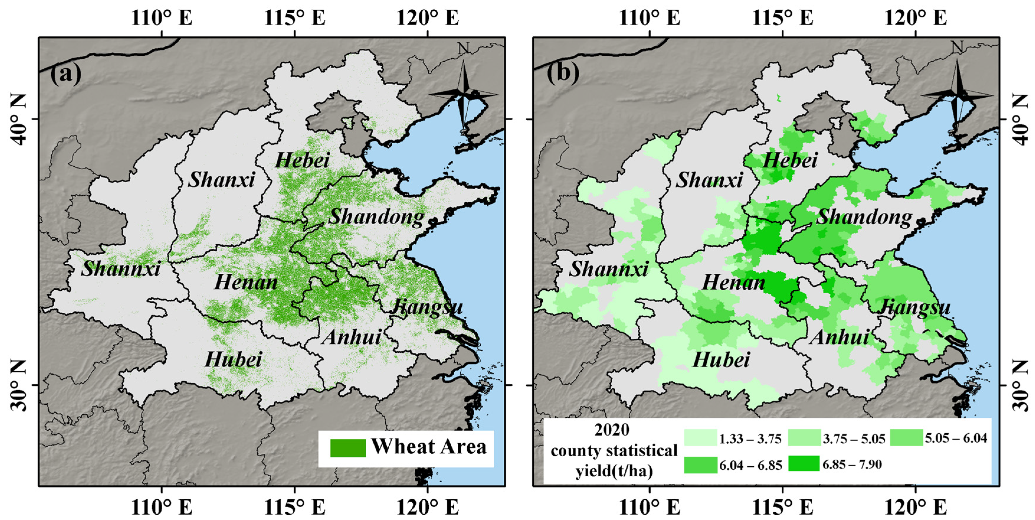
Figure 1. (a) Map showing the distribution of the main winter wheat production areas in China; (b) map showing the distribution of the winter wheat county-level yields for 2020.
Remotesensing 16 03613 g001
Figure 2. Lollipop chart of the yield levels over the four years from 2017 to 2020.
Remotesensing 16 03613 g002
Figure 3. The framework of LGYP (LSTM-GNN-Yield Prediction).
Remotesensing 16 03613 g003
Figure 4. (a) Scatter plot showing predicted yields and statistical yield data for different data sources using Remote sensing (RS) data; (b) scatter plot showing predicted yields and statistical yield data for different data sources using Weather forecast (WF) data; (c) scatter plot showing predicted yields and statistical yield data for different data sources using Remote sensing and Weather forecast (RS-WF) data. Note: *** means the value is significant at the 0.001 level.
Remotesensing 16 03613 g004
Figure 5. The coefficient of determination and root mean square error between the predicted yield and statistical yield data obtained using a yield prediction model for different data sources (RS: Remote sensing data; WF: Weather forecast data; RS-WF: Remote sensing and Weather forecast data).
Remotesensing 16 03613 g005
Figure 6. Scatter plot showing predicted yields and statistical yield data for different weather forecast data series lengths. The labels (ah) in the top-right corner represent the number of days of weather forecasts added, with the unit being days. Note: *** means the value is significant at the 0.001 level.
Remotesensing 16 03613 g006
Figure 7. The coefficient of determination and root mean square error between the predicted yield and statistical yield data obtained using a yield prediction model for different weather forecast data series lengths.
Remotesensing 16 03613 g007
Figure 8. Scatter plot showing predicted yields and statistical yield data from different dates. Note: *** means the value is significant at the 0.001 level.
Remotesensing 16 03613 g008
Figure 9. Changes in the coefficient of determination and root mean square error between statistical data and predictions made using data from different dates.
Remotesensing 16 03613 g009
Figure 10. (a) Predicted yield of winter wheat in major provinces and counties of China for the years 2017–2020, (b) statistical yield values, and (c) difference between predicted and statistical data.
Remotesensing 16 03613 g010
Disclaimer/Publisher’s Note: The statements, opinions and data contained in all publications are solely those of the individual author(s) and contributor(s) and not of MDPI and/or the editor(s). MDPI and/or the editor(s) disclaim responsibility for any injury to people or property resulting from any ideas, methods, instructions or products referred to in the content.