Review

GNSS Carrier-Phase Multipath Modeling and Correction: A Review and Prospect of Data Processing Methods

by
Qiuzhao Zhang
1,*,
Longqiang Zhang
1,
Ao Sun
1,
Xiaolin Meng
2,
Dongsheng Zhao
1 and
Craig Hancock
3
1
School of Environment and Spatial Informatics, China University of Mining and Technology, Xuzhou 221116, China
2
College of Architecture and Civil Engineering, Beijing University of Technology, Beijing 100124, China
3
School of Architecture, Building and Civil Engineering, Loughborough University, Loughborough LE11 3TU, UK
*
Author to whom correspondence should be addressed.
Remote Sens. 2024, 16(1), 189; https://doi.org/10.3390/rs16010189
Submission received: 17 November 2023 / Revised: 11 December 2023 / Accepted: 11 December 2023 / Published: 2 January 2024

Abstract

:
A multipath error is one of the main sources of GNSS positioning errors. It cannot be eliminated by forming double-difference and other methods, and it has become an issue in GNSS positioning error processing, because it is mainly related to the surrounding environment of the station. To address multipath errors, three main mitigation strategies are employed: site selection, hardware enhancements, and data processing. Among these, data processing methods have been a focal point of research due to their cost-effectiveness, impressive performance, and widespread applicability. This paper focuses on the review of data processing mitigation methods for GNSS carrier-phase multipath errors. The paper begins by elucidating the origins and mitigation strategies of multipath errors. Subsequently, it reviews the current research status pertaining to data processing methods using stochastic and functional models to counter multipath errors. The paper also provides an overview of filtering techniques for extracting multipath error models from coordinate sequences or observations. Additionally, it introduces the evolution and algorithmic workflow of sidereal filtering (SF) and multipath hemispherical mapping (MHM), from both coordinate and observation domain perspectives. Furthermore, the paper emphasizes the practical significance and research relevance of multipath error processing. It concludes by delineating future research directions in the realm of multipath error mitigation.

Graphical Abstract

1. Introduction

Since the deployment of GPS in 1995 and the successful establishment of the BDS-3 global network in 2021, globally, global navigation satellite systems (GNSSs) are composed of four major satellite navigation systems, the global positioning system (GPS) of the USA, the global navigation satellite system (GLONASS) of Russia, the BeiDou navigation satellite system (BDS) of China, and the Galileo satellite navigation system (Galileo) of the European Union [1]. GNSSs offer users all-weather 3D coordinates and velocity and time information at any point on the Earth’s surface or in the near-Earth space [2]. It possesses notable advantages, such as high accuracy, robust real-time capabilities, and a broad spectrum of applications. In comparison to other positioning systems, BDS not only provides navigation positioning and timing services, but also provides regional message communication and global SMS communication, global search and rescue services, regional precise point positioning services, embedded satellite-based enhanced services, and space environment monitoring functions [3].
Leveraging its unique advantages, GNSS observation technology finds widespread application in deformation monitoring and user position navigation and positioning. The GNSS receiver captures both direct signals from the satellite and signals reflected from the surrounding environment. The superimposition of the reflected signals onto the direct signals introduces errors in the positioning results [4]. The resulting positioning error is termed multipath error. GNSS positioning involves various errors, including satellite ephemeris error, satellite clock error, multipath error, ionospheric delay, and tropospheric delay [5]. In short baseline relative positioning, double-difference observations can mitigate or eliminate the influence of various errors, such as satellite and receiver clock errors and ionosphere and tropospheric delay errors. However, multipath errors, being associated with the station’s surrounding environment, cannot be mitigated by double-difference methods [6]. Particularly in complex environments, like deep mountains, woods, canyons, slopes, lakes, and urban areas, the presence of unavoidable reflectors leads to the generation of numerous satellite reflection signals, causing significant multipath effects. At this time, the multipath error becomes the primary source of errors affecting the accuracy of GNSS data processing in deformation monitoring and navigation positioning.
GNSS multipath errors are categorized into two types: satellite-side multipath errors and station-side multipath errors. Satellite-side multipath errors refer to the measurement errors caused by the multipath effect, which is caused by the signal reflected by the satellite itself [7]. Station-side multipath errors mean that there are reflectors in the environment around the station, and the reflected signals enter the receiver antenna and interfere with the signals directly from the satellite, making the observed value deviate from the true value. Satellite-side multipath errors are systematic errors, which are related to satellite elevation and can be eliminated by the fitting modeling method [8]. Station-side multipath errors are related to the surrounding environment of the station, and the surrounding environment of the station is their direct cause. GNSS multipath errors are classified using observations into two types: pseudo-range multipath errors and carrier-phase multipath errors. Under line-of-sight conditions, for the coarse acquisition (C/A) code, the impact of the multipath may reach 10~20 m, and in the most serious case, it may be as high as 100 m. The maximum impact on the precise code can be about 10 m. Under line-of-sight conditions, theoretically, the maximum value of the carrier-phase measurement error caused by the multipath effect is 1/4 of the carrier wavelength [9]. Multipath errors significantly impact the positioning accuracy and reliability [10] and are the primary error in high-precision positioning [11]. Multipath error mitigation is of great significance for further improving GNSS positioning accuracy [12]. It has significant research implications in application fields, such as deformation monitoring and urban positioning, and is also a key and hot topic in the field of GNSS research [13].
At present, there are primarily three approaches for mitigating multipath errors. The first involves the strategic selection of a suitable station to avoid a large number of reflectors in the surrounding environment of the station. The second method entails enhancing hardware components, including antennas and receivers, to inhibit the ingress of reflected signals into the antenna and suppress multipath effects during the receiver signal processing stage. The third method involves post-processing data, encompassing techniques such as the signal-to-noise ratio method, sidereal filtering (SF), and multipath hemispherical map (MHM). Despite the merits associated with these methods, they are not without limitations. Notably, sidereal filtering and the hemispherical multipath map exploit the repetitive characteristics of multipath errors in both the time and spatial domains, demonstrating effectiveness in mitigating multipath errors. These are recent common methods and are also research hotspots.
This paper predominantly focuses on the carrier-phase multipath error occurring at the station side in GNSSs. In Section 2, its principle and mitigation methods are explained. In Section 3, an overview of its research status is provided, with a focus on the commonly employed software methods, such as the sidereal filtering method and the multipath hemispherical map model method. In Section 4, the practical significance of mitigating the multipath effect in different application scenarios is discussed. Finally, Section 5 offers a prospective outlook on the future research directions in GNSS multipath research.

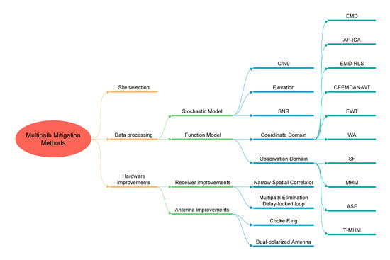
2. Multipath Error Principle and Mitigation Methods

2.1. Generation Principle of Multipath Errors

During the propagation process of the GNSS satellite signal from the satellite to the receiver, the signal reflected by the reflector enters the receiver and interferes with the direct signal, causing the time and phase delays of the satellite signal, making the GNSS observation value deviate from the true value. The interference delay effect caused by the superposition and propagation of satellite signals from different paths is called multipath effect, and the deviation of the GNSS observation value caused by it is called multipath error. There are multipath effects from both the satellite side and the station side. The satellite-side pseudo-range multipath error mostly occurs in BeiDou inclined geosynchronous orbit (IGSO) and middle earth orbit (MEO) satellite pseudo-range observations, and is related to the satellite elevation and belongs to a special systematic error, which is not discussed in this article. The multipath error from the station side is affected by the surrounding environment of the station and cannot be eliminated using the double-difference method. Figure 1a is a schematic diagram of the multipath effect of horizontal ground signal reflection and Figure 1b is a schematic diagram of the multipath effect of vertical building signal reflection.
There is a phase delay θ between the reflected wave and the direct wave. In the case of horizontal ground signal reflection, θ can be expressed as:
θ = 4 π H sin z λ
where H is the height from the antenna to the ground, λ is the carrier wavelength, and z is the incident angle of the reflected signal.
In the case of vertical building signal reflection, θ can be expressed as:
θ = 4 π L cos z λ
where L is the horizontal distance between the antenna and the building reflector.
The multipath error in the carrier-phase measurement can be expressed as [14]:
φ = λ 2 π arctan α sin θ 1 + α cos θ
where α is the reflection coefficient of the reflector.
According to the above formula, the size of the multipath error is affected by factors such as the reflection coefficient of the reflector, the incident angle of the reflected signal, and the spatial relationship between the reflector and the receiver. Since satellite signals are reflected by water bodies, trees, slopes, buildings, and other reflectors, the reflection coefficients are different, resulting in different multipath effects. The theoretical upper limit of the multipath error, denoted as φ, is interconnected with α. In the case of horizontal ground reflection signals, when the incident angle and its rate of change are constant, the frequency of the multipath error is positively correlated with the receiver instrument height. In the case of vertical building reflection signals, when the incident angle and its rate of change are constant, the frequency of multipath errors is positively correlated with the horizontal distance from the instrument to the building. The multipath errors produced by carrier signals of different wavelengths are also different.
Under conditions where the station receiver’s position and its surrounding environment remain stable, with unaltered reflection coefficients and positional relationships between the reflector and the receiver, the incident angle of the reflected signal undergoes regular changes due to the periodic movement of the satellite in a fixed orbit. Due to the periodic repeatability of the GNSS satellite orbital motion, multipath errors have repetitive characteristics in the time domain and spatial domain. Two methods for mitigating multipath errors, namely, sidereal filtering and the multipath hemispherical map, leverage the repeating characteristics of multipath errors.

2.2. Multipath Error Mitigation Methods

The research on multipath error mitigation methods from the station side should be distinguished between occurrences in a line-of-sight (LOS) environment and a non-line-of-sight (NLOS) environment. This paper primarily elucidates the approach to mitigating carrier-phase multipath errors from the station side in a line-of-sight environment.
At present, multipath error mitigation methods can be broadly categorized into three groups: site selection, methods based on hardware improvement, and methods based on software data processing. Site selection involves opting for an open and suitable geographical location to set up a GNSS receiver [15]. The presence of water bodies with high reflection coefficients can significantly impact the multipath error when they surround the station. When there is a large water body around the station, it seriously affects the multipath error. The reflection coefficient of ground vegetation, such as grassland, is low, the reflection signal is weak, and the multipath error generated is small. The antenna suppression plate in the receiver can block most of the reflected signals from the horizontal ground, but when there are high-rise buildings or high-terrain environments around the station, the satellite signal is reflected by the vertical surface and enters the receiver, causing multipath errors. When the measuring station is set on a hillside and the slope is large, it affects the receiver’s reception of satellite signals and produces multipath effects. In station selection, it is advisable to avoid surroundings with high reflection coefficients, such as water bodies and glass, and to steer clear of challenging terrains, like slopes, valleys, and urban canyons. While a judicious site selection can diminish the impact of multipath effects [16], it is subject to relatively significant limitations.
The method of mitigating multipath errors through hardware enhancements encompasses two primary aspects: the antenna method and the receiver method. The antenna method is mainly used to improve the antenna in order to suppress the multipath effect. GNSS signals are right-handed circularly polarized signals, but most of the reflected signals are left-handed circularly polarized signals. The GNSS antenna is designed as a right-handed circularly polarized receiving antenna, which can effectively suppress the reflected signal, because the gain of the incident right-handed circularly polarized signal is larger than that of the left-handed circularly polarized signal [17]. Filippov et al. [18] proposed a choke ring technology for GPS dual-frequency signals in 1998, which can optimize L1 and L2 frequency signals. Ray et al. [19] suppressed low- or negative-altitude signals by adding choke rings. Krantz et al. [20] proposed a new antenna technique using a compression wheel to control the receive pattern in order to reduce multipath effects in GNSS signals. Danskin et al. [21] proposed a choke ring. Groves et al. [22] proposed a dual-polarized antenna technique using the polarization characteristics of GNSS original and reflected signals. Maqsood et al. [23] proposed compact cross-plate reflection planes with a low multipath effect. Zhang et al. [24] proposed a single orthogonal dual linearly polarized GNSS technology to suppress multipath effects through dual linearly polarized antennas. The multipath suppression method based on the antenna technology has a poor multipath suppression effect on low-altitude observation satellites. The receiver method is mainly used to improve the receiver in order to suppress the multipath effect. Nee [25] proposed a multipath elimination delay-locked loop technology to identify and suppress multipath signals in the carrier-phase-locked stage, thereby improving the accuracy of original observations. Chen et al. [26] proposed an improved group-delay multiple amplitude phase-locked loop technology to further improve the multipath suppression effect at the receiver. Dieredonck et al. [27] proposed a narrow spatial correlator technique to suppress multipath effects from the perspective of the receiver hardware. By improving the hardware of the receiver, the effect of alleviating the multipath effect in the middle- and long-band delays is better, but it cannot effectively weaken the impact of the short-band delay. Qiu et al. [28] proposed a multipath mitigation algorithm based on the steepest descent method and designed a new ranging code tracking loop, which has the advantages of a lower computational load and does not require external assistance. This algorithm is computationally more efficient than narrow-pitch correlation techniques. Table 1 summarizes multipath mitigation methods based on the antenna and receiver. By improving the antenna and receiver, the reflected multipath signal from the surrounding environment cannot be completely shielded, and the suppression effect on the multipath effect is limited.
The approach to mitigating multipath errors through software data processing encompasses four key aspects. The first aspect is the multipath suppression method based on a stochastic model. In the second aspect, to leverage the frequency domain characteristics of multipath errors, filtering methods such as Vondrak filtering, empirical mode decomposition (EMD), and wavelet analysis are employed to extract the multipath error time series. These time series are then used to establish a multipath error correction model for post-processing correction. In the third aspect, based on the time domain repetition characteristics of multipath errors, time domain multipath error modeling methods based on the coordinate domain and the observation value domain are developed. The principal methods include sidereal filtering and advanced sidereal filtering (ASF). The fourth aspect is the modeling method based on the repeatability of the multipath spatial domain. The main methods include the multipath spherical harmonic model, multipath stacking (MPS), and multipath hemispherical map. In a static environment, based on the time-spatial domain repetition characteristics of multipath errors, sidereal filtering and hemisphere map model can generate a multipath correction model for real-time GNSS data processing.

3. Research Status of the Multipath Error Data Processing Algorithm

In GNSS relative positioning, the carrier-phase multipath error at the station end is intricately linked to the surrounding environment of the station, which cannot be eliminated by the double-difference method, and is the main source of the errors affecting the positioning results. Consequently, addressing the carrier-phase multipath errors from the station side remains a challenging and focal point in the field of GNSS positioning error processing. Since the 1990s, scholars globally have been engaged in research aimed at mitigating carrier-phase multipath errors, approaching the issue from various perspectives. Numerous multipath error correction methods, based on software data processing, have been proposed as a result of these endeavors. These correction methods can be categorized into two groups based on different research perspectives: mitigation methods based on the stochastic model and mitigation methods based on the function model.

3.1. Multipath Error Mitigation Methods Based on the Stochastic Model

A stochastic model that reasonably weighs observations through the satellite’s elevation, signal to noise ratio (SNR), and carrier-to-noise power density ratio (C/N0) can mitigate multipath errors and improve the positioning results. C/N0 reflects the quality of GNSS observations. Brunner et al. [29], based on the SIGMA-Δ stochastic model using the measured C/N0, demonstrated the ability of the SIGMA-Δ model to reduce signal diffraction effects on static GPS measurements and high-precision GPS railway measurements. This method improves the accuracy of GPS results by more than 50% over the standard GPS processing techniques. According to the correlation between the SNR and multipath effects, the oscillatory variation in the SNR can reflect the influence of the multipath effect. Reducing the weight or identifying and eliminating poor observation data can reduce the impact of multipath effects. Zhang et al. [30] used the signal to noise ratio as an evaluation index and verified through experimental data that reducing the weight of the observations affected by multipath effects can mitigate multipath errors. Liu and Dick [31] constructed a GPS-refined stochastic model using the correspondence between the variance in GPS observations and the signal to noise ratio. The measured data showed that the accuracy of baseline processing can be improved, which verifies the validity and necessity of GPS stochastic model refinement. GNSS observations with higher elevations are more precise. Ding [32] added three models based on satellite elevation, signal to noise ratio, and least-squares residual error to the high-precision IGS station baseline vector calculation to improve the calculation accuracy. Strode and Groves [33] developed a multipath detector based on the signal to noise ratio of three frequencies, detected GNSS multipath errors by comparing the signal to noise ratio measurements of the three frequencies, and tested and verified its multipath detection capability in an urban environment. Zhang et al. [34] proposed a real-time adaptive weighting model based on satellite elevation and C/N0, which can reduce multipath errors, and applied it to simplified parallel process (SPP) and real-time differential (RTD). The test results showed that the adaptive model was better than the equal weight model, elevation model, and C/N0 model. Zhang [35] proposed a real-time multipath detection method using dual-frequency C/N0, which improves the reliability of multipath detection. Xi et al. [36] analyzed the SNR characteristics of GPS and GLONASS, proposed an improved stochastic model based on the SNR, and reasonably established the link between carrier-phase accuracy and SNR observations. The improved model can be used in real time and can reasonably display carrier-phase accuracy with signal-to-noise ratio data, which is applicable to all GNSSs. Liu et al. [37] proposed a multipath error identification method for GNSS observation data based on the prior information of the signal to noise ratio of reference stations. Satellite signal to noise ratio observations have a strong correlation with multipath errors. Poor data that are seriously affected by multipath effects can be identified by the inter-station difference of SNR observations, and they are eliminated to resist the multipath effects’ influence on monitoring complex environments.
The equal-weight model assumes uniform accuracy for each observation, overlooking the impact of errors such as elevation and multipath effects on observation accuracy and deviating from the real conditions. Stochastic models that use elevation, SNR, or C/N0 to determine the weight are more in line with the actual situation and reflect the quality and precision of the observations. Some popular stochastic models are presented in Table 2.

3.2. Multipath Error Mitigation Method Based on the Function Model

The multipath mitigation method based on the function model refers to the construction of the corresponding multipath error correction model by using the physical or geometric relationship between the observation value or coordinate value in the GNSS data and the multipath error. Based on the time domain repetition characteristics of multipath errors, the time domain multipath error modeling method using the calculated satellite orbit repeat period is called sidereal filtering (SF). Another classic modeling method based on the repeatability of the multipath spatial domain is the multipath hemisphere map (MHM). Genrich and Bock [38] first proposed sidereal filtering, using the satellite orbit repeat period, and established a multipath error correction model by calculating the satellite repeat period. Choi et al. [39] studied the repeat period of the GPS orbit and found that the repeat period is different for each satellite. Agnew and Larson et al. [40] used the orbital period and the topological center position of the satellite to calculate the repetition time and found that the repeat period of the satellite constellation is variable. Modified sidereal filtering (MSF) uses the average of the orbital repetition times of all satellites as the multipath repetition time. However, due to differences in satellite repeat periods, individual multipath modeling for each satellite is most efficient, called advanced sidereal filtering (ASF). Sidereal filtering has been applied to the coordinate domain and the observation domain. The multipath error is extracted from the previous coordinate sequence by the filtering method, and the multipath error of the coordinate sequence in the next cycle is corrected according to the calculated repeat period to obtain the corrected coordinate sequence. This coordinate domain-based sidereal filtering is suitable only for data post-processing and cannot correct multipath errors in real time. The time domain multipath model in the observation domain utilizes the correlation of the observation residuals in the satellite orbit repeat period and extracts the multipath error components in the observation residuals through the time series analysis method to achieve multipath error correction for observations in the next satellite orbit repeat period [41], which corresponds to the sidereal filtering method based on the observation domain.
Sidereal filtering (SF) exerts a substantial impact on mitigating multipath errors in static environments. However, it proves unsuitable for dynamic scenes as it necessitates the advance calculation of the satellite repeat period, involving extensive modeling and intricate calculations. Compared with the coordinate domain, SF in the observation domain is more suitable for BDS containing three orbit types. MHM can significantly weaken the multipath error in the observation domain, and can be applied to precise point positioning and dynamic scenes, where the surrounding scenes remain unchanged. MHM is particularly adept at low-frequency multipath error correction rather than high-frequency multipath error correction. In addition, it is not well-suited for conventional receivers.

3.2.1. Multipath Error Mitigation Method Based on the Coordinate Domain

The coordinate sequence of the previous repeat period is analyzed using the filtering method to extract the multipath error time series in the coordinate domain, and then the multipath error correction model is constructed. Based on the repetitive characteristic of multipath effects, multipath error correction is performed on the sequence of coordinates for the next repeat period. The GPS/BDS/GLONASS/Galileo repeat period can be observed in Table 3. It is a key point to use various filtering methods to denoise and isolate the multipath correction model with repeatability. Such methods can only be used for data post-processing. Zheng et al. [42] proposed a data filtering method called cross-validation Vondrak filter (CVVF) based on the Vondrak filter and cross-validation technology, which is used for signal and noise separation in data sequences and is applied to mitigate GPS multipath effects for deformation monitoring. Dai et al. [43] established a new denoising filtering method based on empirical mode decomposition (EMD) and applied this method to GPS multipath error correction. EMD entails the separation of several basic signals from complex signals, from high frequency to low frequency, and the separated signal is called the intrinsic mode function (IMF). For a signal mixed with random noise, the decomposed high-frequency IMF components are usually the noise of the signal and the low-frequency components are multipath signals. However, EMD presents problems that need to be addressed. Xue and Luo proposed two methods based on EMD improvements, ensemble empirical mode decomposition (EEMD) [44] and complete ensemble empirical mode decomposition (CEEMD) [45], to filter and denoise the signal. EEMD and CEEMD are able to mitigate the modal aliasing problem in EMD. Tong [46] proposed a method for extracting GPS/BDS-3 multipath errors based on complete ensemble empirical mode decomposition with adaptive noise (CEEMDAN)-wavelet transform (WT). The positioning results of this method were better than those of EEMD and CEEMD. Chen et al. [47] used the IMF obtained by EMD as the input and applied the generalized eigenvalue decomposition (GED) blind source separation algorithm to extract the multipath error model of the repeat period. Yan et al. [48] first used EMD to decompose the original signal to obtain three IMFs, and then used the recursive least-squares algorithm (RLS) to filter the mixed IMFs. The obtained new IMF and information IMF were reconstructed to extract the multipath error correction model. Singular spectrum analysis is an effective method for extracting information from short noise time series. Lu et al. [49] proposed a new SSA filtering method based on the significant difference between noise and signal Hurst exponents, and verified its effectiveness using GPS data. Zhong et al. [50] proposed a wavelet signal-layer automatic identification method based on cross-validation technology, which can separate the noise whose amplitude level is lower than about half of the signal amplitude, and applied it to the mitigation of GPS multipath effects. The repeatability of multipath effects is the highest for two consecutive periods; however, repeatability decreases as the time between the first period and subsequent periods increases. In order to solve this problem, Dai et al. [51] developed a combined method of principal component analysis and empirical mode decomposition and independent component analysis with reference (PCA-EMD-ICA-R), which analyzes the coordinate time series of the first period to obtain the reference multipath model for the second period and has a significant multipath error mitigation effect in both static and dynamic environments. Luo et al. [52] combined the advantages of the empirical wavelet transform (EWT) algorithm in decomposing complex signals with the diurnal repetition characteristics of GNSS multipath errors, and proposed a new method for extracting and correcting multipath errors based on EWT. Zhang et al. [53] used the height of the high-speed rail track as a constraint to solve GPS data, and then analyzed the coordinate sequence with wavelet, which weakened the multipath error of rail train positioning in a dynamic environment. Cao et al. [54] compared and analyzed the ability of two least-squares harmonic estimation methods, unit harmonic estimation and multi-harmonic estimation, to extract multipath errors in the coordinate domain. Yuan et al. [55] proposed an adaptive fast independent component analysis (AF-ICA) method, which can effectively separate and weaken multipath signals when applied to GNSS deformation monitoring.
The algorithm flow of the sidereal filtering method based on the coordinate domain to weaken the multipath error is shown in Figure 2. Firstly, the GNSS baseline monitoring data of the first period is solved to obtain the coordinate solution of the corresponding station. The first-period data are pre-processed, and BDS MEO satellites are not considered in the case of GPS/BDS fusion positioning. Then, filter processing, such as wavelet analysis, is performed to extract the low-frequency components of the data, so as to obtain the periodic error sequence related to the multipath effect. Then, the calculated average repeat period is used to obtain the multipath error correction model based on SF. This model is used to correct the coordinate data of the second period epoch by epoch, and finally, the coordinates after multipath error correction are obtained.

3.2.2. Multipath Error Mitigation Method Based on the Observation Domain

The multipath error is related to the geometric relationship among the measuring station, the reflector, and the satellite position. In a static environment, the multipath error presents a repeating regularity in time domain and spatial domain as the position of the satellite moves [56]. In an unobstructed observation environment, the satellite single-difference residual sequence theoretically presents the characteristics of white noise and is related to the satellite elevation. The satellite single-difference residual sequence under the influence of the multipath effect presents a low-frequency fluctuation trend, and the low-frequency component is the observation domain error caused by the multipath effect. There is a strong correlation between the low-frequency components of different satellite repeat periods. The achievement of multipath error correction in the time domain is divided into three steps: extracting the low-frequency component of the single-difference residual of each satellite; calculating the time offset of the satellite repeat period; and correcting the observations in the next satellite repeat period. Zhong et al. [57] proposed an algorithm to convert double-difference residuals to single-difference residuals based on the “zero-mean assumption”. By establishing a reference period single-difference multipath model for each satellite, and using the periodicity of multipath errors, multipath error correction is performed on the observations in the following periods. v experimental results showed that the method is applicable to different GPS satellites and can effectively correct long-period and short-period multipath errors. Wang et al. [58] proposed three methods for calculating satellite repetition shift times, which are the broadcast ephemeris method (BEM), the correlation coefficient method (CCM), and the aspect repetition time method (ARTM). Wang et al. [59] compared the performance of ASF with modified sidereal filtering (MSF) to evaluate the ability to weaken the multipath error, and the performance of ASF was slightly higher than that of MSF. Li et al. [60] discussed how to model multipath errors in the observed range and evaluated the accuracy of the model algorithm using real-time deformation monitoring data. In order to accurately estimate the repeat period of multipath errors, Zhan et al. [61] proposed a real-time window matching method, combined with SF, to achieve near real-time positioning.
In order to achieve the extraction of the low-frequency component of the satellite single-difference residual under the influence of multipath effects, where single difference refers to the between-station difference of the carrier-phase measurements for the same satellite, it is necessary to use the filtering method. The classical methods include wavelet analysis, EMD, and the Vondrak filter. Satirapod and Rizos [62] applied wavelet decomposition to GPS double-difference residuals to extract GPS carrier-phase multipath errors. This multipath error component was then removed directly from the GPS carrier-phase observations in subsequent days of observation data. El-Ghazouly [63] conducted a comprehensive evaluation of different wavelet techniques that can be used to attenuate multipath errors and proposed a new method based on the wavelet detrending technique to attenuate carrier-phase multipath errors in the observation domain. Yuan et al. [64] proposed a new unscented Kalman filter (UKF) to estimate the multipath parameters of weak GPS signals. The simulation results demonstrated the effectiveness of the method for estimating the multipath parameters of weak GPS signals with a carrier-to-noise ratio as low as 21 dB-Hz. Zhang et al. [65] used the Kalman filter (KF) and Rauch–Tung–Striebel smoother (RTSS) to extract multipath error sequences from the single-difference residuals of observations and compared it with the wavelet technique and EMD. The experimental results showed that the performance of KF-RTSS was better than that of the wavelet technique and EMD. Lau and Lawrence [66] proposed a general and robust three-stage wavelet denoising method for repetitive time-based carrier-phase multipath filtering in relative positioning. Su et al. [67] used the satellite elevation as the constraint information of the wavelet transform to extract an accurate multipath error model and then used SF for multipath error correction.
The space part of the BDS system consists of GEO, IGSO, and MEO to form a hybrid heterogeneous constellation. There are many high-orbit satellites in BDS that have a strong anti-blocking ability. Due to the unique constellation design of BDS, many scholars have found that the multipath effect characteristics of BDS satellites are significantly different from those of other systems; thus, considerable research has been conducted. Wu et al. [68] proposed a real-time multipath correction algorithm for IGSO and GEO satellites, called code noise and multipath correction (CNMC), which reduces the influence of multipath errors, thus ensuring the performance of the system. Ye et al. [69] applied the sidereal filtering method based on the observation domain to BDS and considered the repeat period of each satellite independently, successfully weakening the BDS carrier-phase multipath error. The results showed that the combined system of GPS and BDS has a higher reliability and higher accuracy than a single system. Ye et al. [70] analyzed the ambiguity fixation rate of BDS and GPS in different resolution modes and weakened the influence of wide-lane multipath effects through the sidereal filtering method in the observation domain. Shi et al. [71] analyzed the multipath repeatability of three types of BeiDou satellites in different orbits by calculating the residual sequence of double-difference observations, and on this basis, studied the influence of multipath effects on the accuracy of the BDS static baseline solution. The results showed that, in a strong multipath environment, the impact of BDS multipath errors on its static solution reaches the centimeter level. Xie et al. [72] used SF based on the coordinate domain to weaken the multipath error of the BeiDou satellite deformation monitoring data, which effectively improved the accuracy of the plane and elevation directions. Based on single-difference residual reconstruction and wavelet decomposition, Yang et al. [73] proposed a BDS system multipath mitigation method combining sidereal filtering and wavelet. Zhang et al. [74] showed that, in the relative positioning of the BDS-2 and BDS-3 systems, MHM can effectively correct the multipath error of low-elevation satellites and improve the success rate of ambiguity resolution, and the positioning accuracy of the floating-point solution and the fixed-point solution can be improved.
The Galileo satellite orbit repeat period is ten days, and the existing SF and MHM need a large amount of data for modeling when dealing with Galileo multipath errors, which is not applicable. The elevation and azimuth between adjacent epochs do not change considerably; thus, it can be considered that the low-frequency phase multipath effect at adjacent epochs is unchanging. Based on this, Hu et al. [75] proposed a random walk multipath method (RWM), which can alleviate Galileo multipath errors and improve the localization accuracy without using historical data. Tian et al. [76] proposed a least-squares collocation (LSC) method based on the covariance function, which can effectively weaken the multipath error when applied to the baseline positioning and precise single-point positioning of GPS and Galileo (Tian and Liu et al. (2023)). This method has a higher modeling efficiency in the Galileo system.
Ragheb et al. [77] compared the sidereal filtering method based on the coordinate domain and the observation domain, and the results showed that the accuracy of the observation domain was slightly higher than that of the coordinate domain, but the calculation efficiency of the coordinate domain was higher, and the processing time of the observation value domain was longer. When using the sidereal filtering method based on the coordinate domain to reduce the multipath effect, the coordinates are obtained from different satellite solutions. The coordinates are mixed with the influence of different satellite signals on the coordinate data. Especially when different constellations are used for multi-system joint positioning, the repeat period of different satellites is very different, which is not conducive to weakening the multipath error. Therefore, multipath modeling should be performed on each system satellite separately in the observation domain. Compared with the two methods, the sidereal filtering based on the observation domain can take into account the multipath error repeat period of each satellite and is more suitable for the reduction in multipath errors of BDS with heterogeneous constellations.
The multipath error correction of SF based on the observation domain is divided into two aspects. Firstly, the SF multipath model is constructed based on the first-phase GNSS observation data; then, the SF model is used to perform multipath error correction on the second-phase GNSS observation data. The algorithm flow of the SF multipath model to correct the multipath error is shown in Figure 3. The algorithm includes the following six steps:
  • According to the first phase of GNSS navigation ephemeris data, the average angular velocity of different satellites is calculated and the time offset of the repeat period of different satellites is obtained.
  • According to the GNSS baseline observation data of the first phase, errors such as satellite clock error, receiver clock error, satellite orbit error, tropospheric delay, and ionospheric delay are eliminated by constructing a double-difference observation equation. The double-difference ambiguity is fixed using the LAMBDA algorithm.
  • Double-difference residuals are converted to single-difference residuals based on the “zero-mean assumption”; wavelet analysis, EMD, or other filters are used to process the signal, and low-frequency components of single-difference residuals are extracted.
  • Using the obtained satellite repetition cycle time offset, the satellite single-difference residual time series is time-corrected based on GPST to obtain the single-difference residual low-frequency component correction model for the next repetition cycle. Finally, the SF model of the observation domain for multipath error mitigation in the next period is obtained.
  • According to the GNSS baseline observation data of the second phase, the satellite single-difference observation equation is constructed, and the corresponding satellite multipath error correction value in the sidereal filtering multipath model is extracted based on the GPST timestamp. The single-difference observation equation weakened by the multipath error is reconstructed into a satellite double-difference observation equation.
  • The Kalman filter is used to estimate the floating-point solution of the ambiguity, and the LAMBDA algorithm is used to fix the double-difference ambiguity. The double-difference ambiguity is substituted into the solution equation to obtain a fixed-point solution for the baseline solution, which mitigated the multipath error.
The geometric relationship between the satellite and the station is used to model and correct the multipath error. The modeling methods based on the repeatability of the multipath spatial domain mainly include the multipath spherical harmonic model, multipath stacking (MPS), and MHM. Based on the principle of superposition, Cohen and Parkinson [78] used spherical harmonics as a calibration function and applied this calibration model to GPS measurements to weaken multipath errors. Fuhrmann et al. [79] proposed MPS that considers geometric and statistical aspects, is able to detect far-field and near-field multipath signals, can be used in real time and for post-processing, and is applicable to all satellite systems.
When the observation environment remains basically unchanged, the change characteristics of the single-difference residual of the satellite carrier observation value are related to the azimuth and elevation, and the change characteristics are consistent in the spatial domain. The single-difference residuals of the carrier observations in different satellites and the different frequencies of the same satellite have different variation characteristics. The MHM model with the receiver as the origin, the elevation as the latitude, and the azimuth as the longitude for grid division can express satellite single-difference residual spatially varying characteristics. Based on the single-receiver multi-antenna hardware and unified time system, Dong et al. [80] directly constructed a single-difference observation equation, taking into account the altitude angle and azimuth angle of each satellite, and established the MHM model suitable for real-time deformation monitoring, which significantly mitigated the impact of multipath errors. Cai et al. [81] extended MHM to the kinematic shipboard environment, conducted static and kinematic tests, and proved the feasibility of MHM. On the basis of MHM, Wang et al. [82] proposed an MHM model based on the trend surface analysis method, called T-MHM, focusing on the correlation of multipath errors in the satellite spatial domain, which effectively mitigated multipath errors. In the baseline E, N, and U directions, T-MHM has a higher positioning accuracy than MHM. To solve the problem of the multicollinearity and overfitting of the fitting parameters in the T-MHM, Wang et al. [83] proposed the AT-MHM method. Theoretically, this method can be applied to carrier-phase multipath error correction. Aiming to obtain the multipath error characteristics of satellites with different elevation values, Zheng et al. [84] proposed an improved MHM, which reduces the influence of multipath errors on precise point positioning under static conditions. Wang et al. [85] proposed a multi-point hemispherical grid model (MHGM) to directly model the double-difference residual, which can be applied to common receiver hardware equipment. Zhang et al. [86] presented the MHM_V model based on variational mode decomposition (VMD) and MHM. They using the VMD algorithm to extract multipath errors from the single-difference residuals and to correct the original observations of the carrier phase within a few days after implementation according to the principle of recent elevation and azimuth angles to mitigate multipath effects. Tang and Liang [87] used ensemble empirical mode decomposition (EEMD) to accurately extract the multipath errors in the observation domain and combined with the MHM model to correct the multipath errors in real time, indicating the importance of the accurate extraction of multipath errors. The development of the MHM method is presented in Table 4.
These methods are adaptable to multiple GNSS systems and can be applied to baseline positioning and precise point positioning. In a relatively constant observation environment, MHM can significantly mitigate multipath errors; thus, this type of model is of great value for evaluating multipath errors, and this is also one of the current research hotspots.
The multipath error correction of MHM is divided into three aspects. Firstly, the multipath error sequence of the GNSS observation data is extracted, and then the MHM model is constructed according to the elevation and azimuth. Finally, the obtained MHM model is used to correct the multipath error of the second-phase GNSS observation data.
The algorithm flow of the MHM model to correct the multipath error is shown in Figure 4, and the algorithm includes the following six steps:
  • Single-difference residual low-frequency components are extracted using the filtering method from the first-period observation data.
  • For different satellite constellations, different hemisphere geometric models are established. Based on the minimum elevation, maximum elevation, azimuth angle, minimum grid latitude, and minimum grid longitude, the hemispherical geometric model of GPS/BDS IGSO/BDS MEO satellites is established; based on the minimum elevation, maximum elevation, minimum azimuth, maximum azimuth, minimum latitude interval, and minimum longitude interval, the semi-celestial geometric model of the BDS GEO satellite is established.
  • Based on the instantaneous elevation and azimuth of the satellite, the low-frequency components of the instantaneous single-difference residual of the satellite are divided into the corresponding grids of the hemispherical geometric model (HGM)/GEO hemispherical geometric model (GEOHGM).
  • The mean value of the low-frequency component of the satellite single-difference residual in each grid is calculated, that is, the parameter fitting of the semi-celestial spherical grid. Finally the MHM/MHMGEO corresponding to HGM/HGMGEO is obtained.
  • The second-phase GNSS baseline monitoring data are used to construct a single-difference observation equation. The grid parameters of the MHM model are obtained based on the satellite azimuth and elevation of the current epoch and the multipath error correction of the single-difference observation equation is conducted.
  • The single-difference observation equation that was weakened by multipath errors was reconstructed into a satellite double-difference observation equation. The LAMBDA algorithm is used to fix the double-difference ambiguity and the double-difference ambiguity is substituted into the solution equation to obtain a fixed-point solution for the baseline solution.

3.2.3. Summary

The precise extraction of multipath models from coordinate sequences or observations is the most important step in multipath error data processing. This can be effectively achieved using filtering methods. According to the spatiotemporal repeatability of multipath errors, the core point of SF is the acquisition of the satellite orbit repeat period, and MHM focuses the fitting of the grid surface and the actual site multipath errors. In the utilization of SF in the coordinate domain, it is advisable to employ satellites with similar repetition periods. Notably, SF in the coordinate domain becomes impractical when dealing with satellites that have significantly divergent repeat periods, which represents a limitation. It can be observed in Table 5 that many filtering methods are used for multipath error correction. Taking into account the satellite constellation structure, the coordinate domain method is suitable for GPS with a simple structure, and the observation value domain method is more suitable for BDS with a complex structure. Most of the methods employ a combination of the filtering method and the SF or MHM models, which can effectively weaken the multipath error.

4. Application Scenarios of the Multipath Error Mitigation Algorithm

4.1. GNSS Deformation Monitoring

Since its development in the 1970s, the GNSS has become an indispensable part of space technology in the new century. With its advantages of high positioning accuracy, fast positioning speed, and precise timing [88], it has been applied in many disciplines, such as transportation, surveying and mapping, communications, deformation monitoring, precision agriculture, machinery control, and the monitoring and forecasting of geological hazards [89]. Since the 1990s, GNSS technology has been applied to deformation monitoring. Compared with traditional deformation monitoring, GNSS monitoring technology has unique advantages in large-scale structural health monitoring: high sampling rate, no need to supervise it, high degree of automation, four-dimensional monitoring, and all-weather monitoring [90]. GNSS monitoring technology can be applied to various monitoring scenarios to meet different monitoring requirements, such as monitoring types, monitoring accuracy, monitoring instruments, and monitoring range [91]. The GNSS deformation monitoring system is an important and effective way to obtain structure safety and health monitoring data. In the monitoring of specific projects, GNSS monitoring technology can obtain the high-precision deformation of structures, obtain vibration signals, and achieve the simultaneous monitoring of real-time and long-term deformation of structures [92]. With the development of global satellite navigation and positioning technology, multi-GNSS system data fusion processing has become a future development trend [93]. This evolution is expected to enhance the usability and reliability of GNSS deformation monitoring [94].
At present, GNSS monitoring technology has been widely used in monitoring fields such as high-rise buildings, dams, bridges, and building tailings. In terms of water dams, in 1995, Behr and Hudnut [95] developed the first GNSS dam non-real-time deformation monitoring system to monitor the deformation displacement of the Pacoima dam by continuously operating the GPS monitoring station system. The GNSS monitoring system can measure the horizontal and vertical displacements of water dams and surrounding adjacent areas, and can obtain centimeter-level or even millimeter-level deformation information [96]; it has also gradually become an important component of the dam safety and stability monitoring system [97]. High-rise buildings and large bridge structures are easily deformed or even damaged by external factors, such as wind, earthquakes, temperature, and vehicles [98]. Kwon et al. [99] established SmartSync, a rapidly deployable health and safety monitoring system at the Burj Khalifa, which accommodates multiple sensor types, including GPS, accelerometers, and weather stations, to monitor real-time deformation information of the Burj Khalifa in Dubai in order to ensure the structural health and safety of the entire structure. Ashkenazi et al. [100] applied GPS to the British Humber Bridge for monitoring experiments. The analysis of the verification test results showed that the GPS signal measurement results obtained very good experimental data, which is consistent with the finite element model analysis results. In terms of landslide monitoring, GNSS monitoring technology performs static calculations through satellite observation data over a period of time and obtains deformation and displacement information of landslide monitoring points within a corresponding period of time. Wang et al. [101] analyzed the reliability and accuracy of GPS technology applied to the dynamic real-time deformation monitoring of landslides by using large-scale physical model tests of landslides.
Obtaining accurate deformation information of the monitored object is the primary purpose of deformation monitoring. The existence of multipath errors seriously affects the data quality of monitoring points and reduces the availability of monitoring point positioning results [102]. When the error is serious, it causes the wrong deformation disaster warning of the monitored object [103]. Wang et al. [104] corrected the multipath error of the GPS data of the Foss Road Bridge through the single-difference sidereal filtering method, and the results showed that the positioning accuracy of the bridge deformation monitoring was greatly improved compared with the original results. Han et al. [105] used the sidereal filtering method to correct the multipath errors of GNSS landslide deformation monitoring data in the Qinba mountainous area and loess monitoring environment in real time, and the positioning residual accuracy was improved to the millimeter level. Chen et al. [106] considered that tropospheric errors and multipath errors exist simultaneously in long-baseline real-time kinematic (RTK) positioning, and corrected tropospheric errors and multipath errors successively by using the undifferenced residuals of satellites. This research provided an effective research strategy for long-baseline, high-precision, real-time dynamic carrier-phase difference technology RTK deformation monitoring. Liu et al. [107] used non-difference, single-difference, and double-difference sidereal filtering methods to process high-speed railway-based BeiDou satellite monitoring data, and the positioning accuracy in the three directions was effectively improved. The sidereal filtering method based on the single-difference procedure has the best effect on weakening the multipath error of high-speed railway foundation deformation monitoring. Tong et al. [108] proposed an empirical wavelet transform independent component analysis reference (EWT-ICA-R) method, which can accurately extract deformation information from GNSS coordinate sequences. The experimental results showed that the extraction of deformation information was expected to achieve submillimeter precision.
The multipath error exhibits a strong correlation with the receiver environment of the station. When monitoring the deformation of the structure, the buildings, water environment, and tree vegetation around the station cause multipath effects. The resultant multipath error, not amenable to elimination through the double-difference method, emerges as the primary source of error. This limitation constrains the broader adoption and application of GNSS positioning technology in the deformation monitoring of structures and geographical environments [109]. The exploration of the multipath error mitigation algorithm has great application value and research significance for high-accuracy deformation monitoring.

4.2. Precise Positioning of Urban Areas

With the increase in urbanization, the demand for location information services, such as mobile phones and vehicles, in urban areas is increasing. According to the 2015 “GNSS Market Report” of the European Union, the two major application markets, location service (LBS) and road navigation, have already occupied a dominant position (91%) in GNSS revenue. GNSS technology in the urban area environment has also received extensive research attention and been widely applied. There is a complex geographical and architectural environment in urban areas, which is mainly due to its large number of buildings and the green environment being scattered in the city. In the application of GNSS positioning techniques within urban environments, the dense positioning of buildings introduces a significant challenge, namely, the occurrence of pronounced reflections of satellite signals during signal propagation. This phenomenon results in a formidable multipath effect, substantially impairing the accuracy and reliability of positioning in urban settings [110]. Xu et al. [111] proposed a multipath estimation, detection, and mitigation method for carrier-phase observations. The experimental results in urban environments showed that the robustness and accuracy of navigation positioning were improved. Lu et al. [112] analyzed and verified the weakening effect of MHM and T-MHM on the PPP multipath effect of the BDS-3 system in a complex urban environment.
The multipath errors in the urban area are mainly divided into non-line-of-sight signal (NLOS) and reflected multipath effects. These two types of errors are essentially caused by the coherent signal of the extra path, and the difference lies in the participation of the direct signal or not. They often co-exist in urban environments, such as dense buildings and elevated areas, causing complex and obvious positioning errors. Due to the difficulty of eliminating these errors through baseline difference technology and the difficulty of obtaining a unified parameterized expression, it has a serious impact on the precise positioning of the urban environment [113]. Therefore, it is of great application value and significance to study the error correction methods of NLOS signals and reflection multipath effects for the achievement of GNSS high-precision positioning in the disciplines of crowd vehicle route navigation and driverless vehicles driving in urban areas [114].

5. Conclusions

The mitigation of GNSS carrier-phase multipath errors is a hot topic with great research significance in the field of navigation signal error processing. Scholars globally have conducted considerable research on the mitigation of multipath errors from various perspectives. In over 30 years of development, there has been notable progress in the research on methods to mitigate GNSS carrier-phase multipath errors. This paper reviewed and summarized the research on GNSS carrier-phase multipath error mitigation in recent years, with a primary focus on introducing the mitigation method of carrier-phase multipath errors from the station side based on software data processing. At present, the sidereal filtering method based on the time domain repetition characteristics of multipath errors and the multipath hemispherical map method based on the spatial domain repetition characteristics of multipath errors are the future research hotspots of multipath error data processing methods.
Future research directions of multipath error mitigation methods could focus on the following three aspects:
  • Extend the current multipath error correction modeling method to the multi-frequency data of multi-GNSS systems, including GPS, BDS, Galileo, GLONASS, and other systems. Zou et al. [115] extended the MHM method and proposed a MHGM (multi-point hemispherical grid model, MHGM) method suitable for multi-GNSS systems. This approach enabled the fusion of observation data from different GNSS systems for MHGM modeling, demonstrating a significant attenuation effect on the multipath errors of GNSS signals. At present, the fusion processing of multi-system and multi-frequency GNSS data has emerged as the future trend in satellite positioning [116]. Research into multipath error processing methods suitable for multi-system and multi-frequency GNSS data constitutes a focal point for future investigations.
  • Enhance the effectiveness of multipath mitigation methods in practical applications. In order to improve the positioning accuracy and operating efficiency in actual engineering practice, research on multipath error mitigation should be developed to achieve real-time application, intelligence [117], and engineering application, and the actual application scenarios should be extended to single-point positioning, dynamic scenes, and more complex environments with severe occlusions.
  • Integrate deep learning and machine learning technology into multipath error mitigation. Xu and Tao [118] used a combination of deep learning network long short-term memory network (LSTM) and EMD to predict and weaken the impact of multipath effects. Tao et al. [119] constructed a time–frequency mask and convolutional neural network (TFM–CNN) model, which had a remarkable effect on separating the multiple paths of GNSS observation sequences in real-time deformation monitoring. Gong et al. [120] used the K-means clustering algorithm from machine learning to distinguish direct signals and reflected signals in urban environments to achieve the purpose of improving positioning accuracy. By processing GNSS data through deep learning and machine learning technology, the strengths of these approaches are leveraged to improve the capability of handling GNSS data and enhance the accuracy and reliability of GNSS positioning results.

Author Contributions

Conceptualization, Q.Z. and L.Z.; methodology, Q.Z. and L.Z.; software, Q.Z. and L.Z.; validation, Q.Z., L.Z., A.S. and X.M.; formal analysis, Q.Z., L.Z. and A.S; investigation, Q.Z., L.Z., D.Z. and C.H.; resources, Q.Z.; data curation, Q.Z. and X.M.; writing—original draft preparation, Q.Z. and L.Z.; writing—review and editing, A.S. and C.H.; visualization, L.Z.; supervision, Q.Z.; project administration, Q.Z.; funding acquisition, Q.Z. All authors have read and agreed to the published version of the manuscript.

Funding

This research was funded by the National Natural Science Foundation of China (No. U22A20569, 42074226, and 42304046) and the Natural Science Foundation of Jiangsu Province (BK20221146).

Data Availability Statement

No new data were created or analyzed in this study. Data sharing is not applicable to this article.

Acknowledgments

We thank the reviewers for their comments, which improved the manuscript.

Conflicts of Interest

The authors declare no conflict of interest.

References

  1. Qu, Y.; Fang, Y.; Li, J. GNSS technology and its development trend. J. Shandong Agric. Adm. Coll. 2010, 27, 156–157+159. [Google Scholar]
  2. Ning, J.; Yao, Y.; Zhang, X. Review of the development of global satellite navigation system. J. Navig. Position. 2013, 1, 3–8. [Google Scholar]
  3. Yang, Y.; Mao, Y.; Sun, B. Basic performance and future developments of Badious global navigation satellite system. Satell. Navig. 2020, 1, 8. [Google Scholar] [CrossRef]
  4. Xu, S. Principle and Application of GPS Measurement, 4th ed.; Wuhan University Press: Wuhan, China, 2008. [Google Scholar]
  5. Li, Z.; Huang, J. GPS Measurement and Data Processing, 3rd ed.; Wuhan University Press: Wuhan, China, 2010. [Google Scholar]
  6. Yi, Q. Research on the Multipath Mitigation Method for GPS/BDS Real-Time High-Precision Deformation Monitoring. Master’s Thesis, Wuhan University, Wuhan, China, 2017. [Google Scholar]
  7. Cai, R. Research on Modeling and Correction Method of Badious Satellite-Induced Multipath Error. Master’s Thesis, Information Engineering University, Zhengzhou, China, 2017. [Google Scholar]
  8. Tao, J. Research on Processing Methods of badious Satellite-Induced Code Multipath Bias. Master’s Thesis, Changsha University of Science & Technology, Changsha, China, 2019. [Google Scholar]
  9. Li, J. Researches on the Algorithms of GNSS Triple Frequency Precise Positioning. Master’s Thesis, Information Engineering University, Zhengzhou, China, 2011. [Google Scholar]
  10. Leica, A. GPS Satellite Surveying, 3rd ed.; Wiley: Hoboken, NJ, USA, 2004. [Google Scholar]
  11. Yuan, L.G.; Huang, D.; Ding, X.L. On the influence of signal multipath effects in GPS carrier phase surveying. Acta Geod. Cartogr. Sin. 2004, 33, 210–215. [Google Scholar]
  12. Shao, C.; Zeng, Q.; QIiu, W.; Xu, R. Overview of GNSS Multipath Mitigation Baseband Processing Algorithm. Navig. Position. Timing. 2022, 9, 1–14. [Google Scholar]
  13. Gao, X. Gnss Carrier Phase Multipath Modeling and Software Development for Structures Deformation Monitoring. Master’s Thesis, China University of Mining and Technology, Xuzhou, China, 2022. [Google Scholar]
  14. Ma, X. The Research on BDS Multipath Error. Master’s Thesis, China University of Mining and Technology, Xuzhou, China, 2017. [Google Scholar]
  15. Xu, G. GPS: Theory, algorithms and applications. In Proceedings of the Springer Publishing Company, Incorporated; Springer Berlin, Heidelberg Publisher: Berlin/Heidelberg, Germany, 2004. [Google Scholar]
  16. Li, S.; Chen, J.; Tan, S.; Zhi, C. Research on multipath limiting antenna array with fixed phase center. GPS Solut. 2015, 19, 505–510. [Google Scholar]
  17. Groves, P. GNSS solutions: Multipath vs. NLOs signals. How does non-line-of-sight reception differ from multipath interference. Inside GNSS Mag. 2013, 8, 40–42. [Google Scholar]
  18. Filippov, V.; Tatarnicov, D.; Ashjaee, J.; Astakhov, A.; Sutiagin, I. The first dual-depth dual-frequency choke ring. In Proceedings of the International Technical Meeting of Satellite Division of the Us Institute of Navigation, Nashville, TN, USA, 15–18 September 1998. [Google Scholar]
  19. Ray, J.; Cannon, M.; Fenton, P. GPS code and carrier multipath mitigation using a multiantenna system. IEEE Trans Aerosp Electron Syst. 2001, 37, 183–195. [Google Scholar] [CrossRef]
  20. Krantz, E. The Design and Performance of The Zephyr Geodetic Antenna. In Proceedings of the International Technical Meeting of the Satellite Division of the Institute of Navigation, Salt Lake City, UT, USA, 11–14 September 2001. [Google Scholar]
  21. Danskin, S.; Bettinger, P.; Jordan, T. Multipath Mitigation under Forest Canopies: A Choke Ring Antenna Solution. For. Sci. 2009, 55, 109–116. [Google Scholar]
  22. Groves, P.D.; Jiang, Z.; Skelton, B.; Cross, P.A. Novel multipath mitigation methods using a dual-polarization antenna. In Proceedings of the ION GNSS 2010, Portland, OR, USA, 21–24 September 2010. [Google Scholar]
  23. Maqsood, M.; Gao, S.; Brown, T.; Unwin, M.; De, V.; Xu, J.D. A Compact Multipath Mitigating Ground Plane for Multiband GNSS Antennas. IEEE Trans. Antennas Propag. 2013, 61, 2775–2782. [Google Scholar] [CrossRef]
  24. Zhang, K.; Li, B.; Zhu, X.; Chen, H.; Sun, G. NLOS Signal Detection Based on Single Orthogonal Dual-Polarized GNSS Antenna. Int. J. Antenn. Propag. 2017, 2017, 8548427. [Google Scholar] [CrossRef]
  25. Nee, R.D.J.V. The Multipath Estimating Delay Lock Loop. In Proceedings of the IEEE Second International Symposium on Spread Spectrum Techniques and Applications, Yokohama, Japan, 29 November–2 December 1992. [Google Scholar]
  26. Chen, X.; Dovis, F.; Peng, S.; Morton, Y. Comparative Studies of GPS Multipath Mitigation Methods Performance. IEEE Trans. Aerosp. Electron. Syst. 2013, 49, 1555–1568. [Google Scholar] [CrossRef]
  27. Dierendonck, A.J.v.; Fenton, P.; Ford, T.J.R. Theory and Performance of Narrow Correlator Spacing in a GPS Receiver. Annu. Navig. 1992, 39, 265–283. [Google Scholar] [CrossRef]
  28. Qiu, W.; Zeng, Q.; Xu, R.; Liu, J.; Shi, J.; Meng, Q. A multipath mitigation algorithm for GNSS signals based on the steepest descent approach. Satell. Navig. 2022, 3, 14. [Google Scholar] [CrossRef]
  29. Brunner, F.K.; Hartinger, H.; Troyer, L. GPS signal diffraction modelling: The stochastic SIGMA-δ model. J. Geod. 1999, 73, 259–267. [Google Scholar] [CrossRef]
  30. Zhang, B.; Huang, J.; Su, L. A research on using SNR values to mitigate carrier phase multipath in GPS surveying. Sci. Surv. Mapp. 2003, 3, 32–35+84. [Google Scholar]
  31. Liu, X.; Dick, D. An Approach to Precise GPS Kinematic Positioning with a Refined Stochastic Model. Acta Geod. Cartogr. Sin. 2003, 32, 293–300. [Google Scholar]
  32. Ding, K. IGS Stations’ High-Precision Solution Based on the Stochastic Model and Its Time Series Analysis. Master’s Thesis, Shandong University of Science and Technology, Qingdao, China, 2010. [Google Scholar]
  33. Strode, P.; Groves, P. GNSS multipath detection using three-frequency signal-to-noise measurements. GPS Solut. 2016, 20, 399–412. [Google Scholar] [CrossRef]
  34. Zhang, Z.; Li, B.; Shen, Y.; Gao, Y.; Wang, M. Site-Specific Unmodeled Error Mitigation for GNSS Positioning in Urban Environments Using a Real-Time Adaptive Weighting Model. Remote Sens. 2018, 10, 1157. [Google Scholar] [CrossRef]
  35. Zhang, Y. Real-time carrier phase multipath detection based on dual-frequency C/N0 data. GPS Solut. 2019, 23, 7. [Google Scholar] [CrossRef]
  36. Xi, R.; Meng, X.; Jiang, W.; An, X.; He, Q.; Chen, Q. A Refined SNR Based Stochastic Model to Reduce Site-Dependent Effects. Remote Sens. 2020, 12, 493. [Google Scholar] [CrossRef]
  37. Liu, J.; Huang, G.; Du, Y.; Bai, Z. Method and Application of Identifying Multipath Errors in GNSS Observation Data Based on Prior Information of Base Station’s Signal-to-noise Ratio. J. Earth Sci. Environ. 2022, 44, 352–362. [Google Scholar]
  38. Genrich, J.; Bock, Y. Rapid resolution of crustal motion at short ranges with the global positioning system. J. Geophys. Res. 1992, 97, 3261. [Google Scholar] [CrossRef]
  39. Choi, K.; Bilich, A.; Larson, K.; Axelrad, P. Modified sidereal filtering: Implications for high-rate GPS positioning. Geophys. Res. Lett. 2004, 31, 178–198. [Google Scholar] [CrossRef]
  40. Agnew, D.; Larson, K. Finding the repeat times of the GPS constellation. GPS Solut. 2007, 11, 71–76. [Google Scholar] [CrossRef]
  41. Chen, D.; Ye, S.; Liu, Y.; Liu, Z. Applied analysis of GPS multipath errors based on observation domain. Wuhan Daxue Xuebao (Xinxi Kexue Ban)/Geomat. Inf. Sci. Wuhan Univ. 2014, 39, 147–151. [Google Scholar] [CrossRef]
  42. Zheng, D.; Zhong, P.; Ding, X.; Chen, W. Filtering GPS time-series using a Vondrak filter and cross-validation. J. Geod. 2005, 79, 363–369. [Google Scholar] [CrossRef]
  43. Dai, W.; Ding, X.; Jian, J.; Chen, Y.; Li, Z. EMD filter method and its application in GPS multipath. Acta Geod. Cartogr. Sin. 2006, 35, 321–327. [Google Scholar]
  44. Xue, Z. A Study of Key Technology for Dynamic Deformation Monitoring Using GNSS. Ph.D. Thesis, Information Engineering University, Zhengzhou, China, 2012. [Google Scholar]
  45. Luo, C.; Feng, W.; Ding, Y. GPS Multipath Correction Model Research Based on CEEMD. J. Geod. Geodyn. 2018, 38, 381–385. [Google Scholar]
  46. Tong, R. Research on GPS/BDS-3 Multipath Error Reduction Based on Combining Complete Ensemble Empirical Mode Decompositions with Adaptive Noise and Wavelet Transform. Mod. Inf. Technol. 2022, 6, 45–47+51. [Google Scholar]
  47. Chen, J.; Yue, J.; Liu, Z.; Zhu, S.; Chen, H. Blind source separation algorithm of generalized eigen-value decomposition based on reference signal and its application in BDS multipath. J. Chin. Inert. Technol. 2018, 26, 18–23. [Google Scholar]
  48. Yan, C.; Wang, Q.; Yang, G.; Zhang, H. EMD-RLS combination algorithm and its application in weakening BDS multipath error. J. Chin. Inert. Technol. 2019, 27, 190–198. [Google Scholar]
  49. Lu, C.; Kuang, C.; Yi, C.; Zhang, Z. Singular Spectrum Analysis Filter Method for Mitigation of GPS Multipath Error. Geomat. Inf. Sci. Wuhan Univ. 2015, 40, 924–931. [Google Scholar]
  50. Zhong, P.; Ding, X.; Zheng, D.; Chen, W.; Huang, D. Adaptive wavelet transform based on cross-validation method and its application to GPS multipath mitigation. GPS Solut. 2008, 12, 109–117. [Google Scholar] [CrossRef]
  51. Dai, W.; Huang, D.; Cai, C. Multipath mitigation via component analysis methods for GPS dynamic deformation monitoring. GPS Solut. 2014, 18, 417–428. [Google Scholar] [CrossRef]
  52. Luo, Y.; Chen, Q.; Huang, C. GNSS Multipath Error Correction Based on Empirical Wavelet Transform. Jgg 2020, 40, 1153–1157. [Google Scholar]
  53. Zhang, R.; Xiong, Y.; Lei, F. A Multipath Error Mitigation Method for GNSS Kinematic Single Epoch Positioning by Fusing Track Inspection Information. Geomat. Inf. Sci. Wuhan Univ. 2021, 46, 905. [Google Scholar] [CrossRef]
  54. Cao, T.; Li, Z.; Gou, H. Research on Least Squares Harmonic Estimation in Extracting the Multipath Effect of GNSS Coordinate Time Series. J. Geod. Geodyn. 2022, 42, 139–142. [Google Scholar]
  55. Yuan, R.; Xie, S.; Li, Z.; He, Z. Adaptive Fast Independent Component Analysis Methods for Mitigating Multipath Effects in GNSS Deformation Monitoring. J. Sens. 2022, 2022, 4604950. [Google Scholar] [CrossRef]
  56. Yin, H.; Gan, W.; Xiao, G. Modified Sidereal Filter and Its Effect on High-rate GPS Positioning. Geomat. Inf. Sci. Wuhan Univ. 2011, 36, 609–611+616. [Google Scholar]
  57. Zhong, P.; Ding, X.; Yuan, L.; Xu, Y.; Kwok, K.; Chen, Y. Sidereal filtering based on single differences for mitigating GPS multipath effects on short baselines. J. Geod. 2010, 84, 145–158. [Google Scholar] [CrossRef]
  58. Wang, M.; Wang, J.; Dong, D.; Li, H.; Han, L.; Chen, W. Comparison of Three Methods for Estimating GPS Multipath Repeat Time. Remote Sens. 2018, 10, 6. [Google Scholar] [CrossRef]
  59. Wang, M.; Wang, J.; Dong, D.; Chen, W.; Li, H.; Wang, Z. Advanced Sidereal Filtering for Mitigating Multipath Effects in GNSS Short Baseline Positioning. ISPRS Int. J. Geoinf. 2018, 7, 228. [Google Scholar] [CrossRef]
  60. Li, P.; Hu, Z.; Zhou, R.; Zhao, Q. The Multipath Mitigation Method Based on Observation Domain and Its Application in GNSS Real-Time Deformation Monitoring. J. Geod. Geodyn. 2018, 38, 840–845. [Google Scholar]
  61. Zhan, W.; He, X.; Jia, D.; Zhang, Z.; Zhang, Y. Mitigation of multipath effects in GPS and BDS positioning using window matching method based sidereal filtering. Acta Geod. Geophys. 2022, 57, 427–446. [Google Scholar] [CrossRef]
  62. Satirapod, C.; Rizos, C. Multipath mitigation by wavelet analysis for GPS base station applications. Surv. Rev. 2005, 38, 2–10. [Google Scholar] [CrossRef]
  63. El-Ghazouly, M. Assessment of wavelets analysis for carrier-phase multipath mitigation. Can. J. Earth Sci. 2009, 46, 627–636. [Google Scholar] [CrossRef]
  64. Yuan, G.; Xie, Y.; Yang, S.; Liang, H. Multipath parameters estimation of weak GPS signal based on new colored noise unscented Kalman filter. In Proceedings of the IEEE International Conference on Information & Automation, Harbin, China, 20–23 June 2010. [Google Scholar]
  65. Zhang, Q.; Yang, W.; Zhang, S.; Liu, X. Characteristics of BeiDou Navigation Satellite System Multipath and Its Mitigation Method Based on Kalman Filter and Rauch-Tung-Striebel Smoother. Sensors 2018, 18, 198. [Google Scholar] [CrossRef] [PubMed]
  66. Lau, L. Wavelet packets based denoising method for measurement domain repeat-time multipath filtering in GPS static high-precision positioning. GPS Solut. 2017, 21, 461–474. [Google Scholar] [CrossRef]
  67. Su, M.; Feng, W.; Qiao, L.; Qiu, Z.; Zhang, H.; Zheng, J.; Yang, Y. An improved time-domain multipath mitigation method based on the constraint of satellite elevation for low-cost single frequency receiver. Adv. Space Res. Off. J. Comm. Space Res. (COSPAR) 2022, 69, 3597–3608. [Google Scholar] [CrossRef]
  68. Wu, X.; Zhou, J.; Wang, G.; Hu, X.; Cao, Y. Multipath error detection and correction for GEO/IGSO satellites. Sci. China Phys. Mech. Astron. 2012, 55, 1297–1306. [Google Scholar] [CrossRef]
  69. Ye, S.; Chen, D.; Liu, Y.; Jiang, P.; Tang, W.; Xia, P. Carrier phase multipath mitigation for BeiDou navigation satellite system. GPS Solut. 2015, 19, 545–557. [Google Scholar] [CrossRef]
  70. Ye, S.; Zhao, L.; Chen, D.; Pan, X.; Du, Z.; Li, Z. Real-time deformation monitoring data processing based on BDS triple-frequency observations. Geomat. Inf. Sci. Wuhan Univ. 2016, 41, 722–728. [Google Scholar] [CrossRef]
  71. Shi, Q.; Dai, W.; Zeng, F.; Zhang, C. The Characteristics of BDS Carrier Phase Multipath and Its Effects on Static Baseline Solution. J. Geod. Geodyn. 2016, 36, 874–878. [Google Scholar]
  72. Xie, B.; Hu, Z. Sidereal Filtering Method Based on Coordinate Domain and Its Application in BeiDou Deformation Monitoring. J. Geomat. 2023, 48, 27–31. [Google Scholar] [CrossRef]
  73. Yang, W.; Zhang, Q.; Ma, X. Strategy for BDS multipath mitigation based on wavelet decomposition and sidereal filter. J. Henan Polytech. Univ. (Nat. Sci.) 2022, 41, 58–64. [Google Scholar]
  74. Zhang, Z.; Dong, Y.; Wen, Y.; Luo, Y. Modeling, refinement and evaluation of multipath mitigation based on the hemispherical map in BDS2/BDS3 relative precise positioning. Measurement 2023, 213, 112722. [Google Scholar] [CrossRef]
  75. Hu, M.; Yao, Y.; Ge, M.; Neitzel, F.; Shi, J.; Pan, P.; Yang, M. Random walk multipath method for Galileo real-time phase multipath mitigation. GPS Solut. 2023, 27, 58. [Google Scholar] [CrossRef]
  76. Tian, Y.; Liu, Z.; Lin, M.; Li, K. Modelling and mitigation of GNSS multipath effects by least-squares collocation considering spatial autocorrelation. J. Geod. 2023, 97, 37. [Google Scholar] [CrossRef]
  77. Ragheb, A.; Clarke, P.; Edwards, S. GPS sidereal filtering: Coordinate- and carrier-phase-level strategies. J. Geod. 2007, 81, 325–335. [Google Scholar] [CrossRef]
  78. Cohen, C.; Parkinson, B. Mitigating multipath error in GPS based attitude determination. In Proceedings of the Guidance & Control, Keystone, CO, USA, 2–6 February 1991. [Google Scholar]
  79. Fuhrmann, T.; Luo, X.; Knopfler, A.; Mayer, M. Generating statistically robust multipath stacking maps using congruent cells. GPS Solut. 2015, 19, 83–92. [Google Scholar] [CrossRef]
  80. Dong, D.; Wang, M.; Chen, W.; Zeng, Z.; Song, L.; Zhang, Q.; Cai, M.; Cheng, Y.; Lv, J. Mitigation of multipath effect in GNSS short baseline positioning by the multipath hemispherical map. J. Geod. 2016, 90, 255–262. [Google Scholar] [CrossRef]
  81. Cai, M.; Chen, W.; Dong, D.; Song, L.; Wang, M.; Wang, Z.; Zhou, F.; Zheng, Z.; Yu, C. Reduction of Kinematic Short Baseline Multipath Effects Based on Multipath Hemispherical Map. Sensors 2016, 16, 1677. [Google Scholar] [CrossRef] [PubMed]
  82. Wang, Z.; Chen, W.; Dong, D.; Wang, M.; Cai, M.; Yu, C.; Zheng, Z.; Liu, M. Multipath mitigation based on trend surface analysis applied to dual-antenna receiver with common clock. GPS Solut. 2019, 23, 104. [Google Scholar] [CrossRef]
  83. Wang, Z.; Chen, W.; Dong, D.; Zhang, C.; Zheng, Z. An Advanced Multipath Mitigation Method Based on Trend Surface Analysis. Remote Sens. 2020, 12, 3601. [Google Scholar] [CrossRef]
  84. Zheng, K.; Zhang, X.; Li, P.; Li, X.; Ge, M.; Guo, F.; Sang, J.; Schuh, H. Multipath extraction and mitigation for high-rate multi-GNSS precise point positioning. J. Geod. 2019, 93, 2037–2051. [Google Scholar] [CrossRef]
  85. Wang, Y.; Zou, X.; Tang, W.; Cui, J.; Li, Y. A method for mitigating GNSS multipath effect based on multi-point hemispherical grid model. Acta Geod. Cartogr. Sin. 2020, 49, 461–468. [Google Scholar] [CrossRef]
  86. Zhang, R.; Gao, C.; Zhao, Q.; Peng, Z.; Shang, R. An Improved Multipath Mitigation Method and Its Application in Real-Time Bridge Deformation Monitoring. Remote Sens. 2021, 13, 2259. [Google Scholar] [CrossRef]
  87. Tang, L.; Liang, S. Research on multipath correction of observation range based on EEMD-MHM model. Hydrogr. Surv. Charting 2022, 42, 54–58+64. [Google Scholar]
  88. Liu, J.; Cao, C. Development status and trend of global navigation satellite system. J. Navig. Position. 2020, 8, 1–8. [Google Scholar]
  89. Schaub, L. GPS Status and Modernization Progress: Service, Satellites, Control Segment, and Military GPS User Equipment. In Proceedings of the 31st International Technical Meeting of The Satellite Division of the Institute of Navigation (ION GNSS+ 2018), Miami, FL, USA, 24–28 September 2018. [Google Scholar]
  90. Yu, J.; Meng, X.; Shao, X.; Yan, B.; Yang, L. Identification of dynamic displacements and modal frequencies of a medium-span suspension bridge using multimode GNSS processing. Eng. Struct. 2014, 81, 432–443. [Google Scholar] [CrossRef]
  91. Meng, X.; Dodson, A.; Roberts, G. Detecting bridge dynamics with GPS and triaxial accelerometers. Eng. Struct. 2007, 29, 3178–3184. [Google Scholar] [CrossRef]
  92. Xiao, Y.; Jiang, W.; Chen, H.; Yuan, P.; Xi, R. Research and Realization of Deformation Monitoring Algorithm with Millimeter Level Precision Based on BeiDou Navigation Satellite System. Acta Geod. Cartogr. Sin. 2016, 45, 16–21. [Google Scholar] [CrossRef]
  93. Li, M. Research on Multi-Gnss Precise Orbit Determination Theory and Application. Ph.D. Thesis, Wuhan University, Wuhan, China, 2011. [Google Scholar]
  94. Breuer, P.; Chmielewski, T.; Górski, P.; Konopka, E. Application of GPS technology to measurements of displacements of high-rise structures due to weak winds. J. Wind. Eng. Ind. Aerodyn. 2002, 90, 223–230. [Google Scholar] [CrossRef]
  95. Behr, J.; Hudnut, K.; King, N. Monitoring structural deformation at pacoima dam, california using continuous gps. In Proceedings of the 11th International Technical Meeting of the Satellite Division of the Institute of Navigation (ION GPS 1998), Nashville, TN, USA, 15–18 September 1998. [Google Scholar]
  96. Guo, B. Application of GPS Technology in Reservoir Dam Deformation Monitoring. Geomat. Spat. Inf. Technol. 2020, 43, 103–106. [Google Scholar]
  97. Hu, X.; Chen, S. The Application of GPS in Dam Deformation Observation. Shanxi Hydrotech. 2015, 4, 119–122. [Google Scholar]
  98. Niu, Y. Investigation of and Modal Parameter Identification Algorithm of Super High-Rise Buildings and Long-Span Bridges Based on GNSS Measurement. Ph.D. Thesis, Tianjin University, Tianjin, China, 2019. [Google Scholar]
  99. Kwon, D.; Kijewski-Correa, T.; Kareem, A. SmartSync: An integrated real-time monitoring and system identification platform for tall buildings. In Proceedings of the 5th World Conference on Structural Control and Monitoring, Tokyo, Japan, 12–14 July 2010. [Google Scholar]
  100. Ashkenazi, V.; Brown, C.; Roberts, G.; Evans, R.; Karuma, R. Monitoring of structures using the global positioning system. Struct. Build. 1999, 134, 97–105. [Google Scholar]
  101. Wang, L.; Zhang, Q.; Li, X.; Zhang, Y.; Guan, J.; Tu, R. Dynamic and real time deformation monitoring of landslide with GPS-RTK Technology. J. Eng. Geol. 2011, 19, 193–198. [Google Scholar]
  102. Zeng, Z. Modeling on Static Multipath in Short Baseline by Using Two Antennae with Share Clock in One Receiver. Master’s Thesis, East China Normal University, Shanghai, China, 2015. [Google Scholar]
  103. Wu, H. Research on Identification and Early Warning Methods of Deformation Information in GNSS Time Series. Master’s Thesis, Anhui University of Science and Technology, Huainan, China, 2019. [Google Scholar]
  104. Wang, D.; Meng, X.; Gao, C.; Pan, S.; Chen, Q. Multipath Extraction and Mitigation for Bridge Deformation Monitoring Using A Single-difference Model. Adv. Space Res. 2017, 60, 2882–2895. [Google Scholar] [CrossRef]
  105. Han, J.Q.; Huang, G.W.; Li, Z. Multipath effect analysis and processing method of gnss landslide monitoring under complicated environment. J. Earth Sci. Environ. 2018, 40, 355–362. [Google Scholar]
  106. Chen, D.; Ye, S.; Xia, F.; Cheng, X.; Zhang, H.; Jiang, W. A multipath mitigation method in long-range RTK for deformation monitoring. GPS Solut. 2022, 26, 96. [Google Scholar] [CrossRef]
  107. Liu, T.; He, X.; Jia, D.; Zhan, W. Application of Sidereal Filtering in Observation Domain in Deformation Monitoring of High Speed Railway Subgrade. J. Navig. Position. 2023, 11, 39–47. [Google Scholar]
  108. Tong, R.F.; Liu, C.; Tao, Y.; Fan, Y.; Chen, J. Deformation Information Extraction from Multi-GNSS Coordinate Series Based on EWT-ICA-R. Sustainability 2023, 15, 4578. [Google Scholar] [CrossRef]
  109. Huang, S.; Li, P.; Yang, B.; Xiang, D. Characteristics of Multipath Effects in GPS Dynamic Deformation Monitoring. Geo-Spat. Inf. Sci. 2006, 9, 79–83. [Google Scholar] [CrossRef]
  110. Groves, P.; Jiang, Z.; Lei, W.; Ziebart, M. Intelligent Urban Positioning using Multi-Constellation GNSS with 3D Mapping and NLOS Signal Detection. In Proceedings of the International Technical Meeting of the Satellite Division of the Institute of Navigation, Nashville, TN, USA, 17–21 September 2012. [Google Scholar]
  111. Xu, B.; Zhang, S.; Kuang, K.; Li, X. A unified cycle-slip, multipath estimation, detection and mitigation method for VIO-aided PPP in urban environments. GPS Solut. 2023, 27, 59. [Google Scholar] [CrossRef]
  112. Lu, R.; Chen, W.; Zhang, C.; Li, L.; Peng, Y.; Zheng, Z. Characteristics of the BDS-3 multipath effect and mitigation methods using precise point positioning. GPS Solut. 2022, 26, 41. [Google Scholar] [CrossRef]
  113. Wang, Z. Research on GPS Multipath Effect Correction Technology in Urban Environment. Ph.D. Thesis, East China Normal University, Shanghai, China, 2020. [Google Scholar]
  114. Dong, Y. Research on Correction Method of Pseudorange Multipath in Urban Area. Master’s Thesis, East China Normal University, Shanghai, China, 2019. [Google Scholar]
  115. Zou, X.; Fu, R.; Wang, Y.; Li, Z.; Xu, Z.; Tang, W.; Li, Y. Inversion of GNSS Multipath Effects Around the Stations and Its Applications. Geomat. Inf. Sci. Wuhan Univ. 2022, 47, 1416–1421. [Google Scholar] [CrossRef]
  116. Chai, Y.; Ou, J.; Yuan, Y. Overview of Data Processing for BDS/GNSS Precise Positioning. Front. Data Comput. 2022, 4, 25–33. [Google Scholar]
  117. Kim, O.; Kee, C. Wavelet and Neural Network-Based Multipath Detection for Precise Positioning Systems. Mathematics 2023, 11, 1400. [Google Scholar] [CrossRef]
  118. Xu, X.; Tao, Y. BDS multipath errors reducing method based on EMD-LSTM coupled prediction model. J. Indian Soc. Remote 2020, 45, 98–104. [Google Scholar]
  119. Tao, Y.; Liu, C.; Liu, C.; Zhao, X.; Xin, H. Joint time–frequency mask and convolutional neural network for real-time separation of multipath in GNSS deformation monitoring. GPS Solut. 2021, 25, 25. [Google Scholar] [CrossRef]
  120. Gong, J.; Ma, R.; Li, D.; Zhao, J. GNSS multipath mitigation method based on k-means classification in urban environment. J. Indian Soc. Remote Sens. 2022, 50, 805–813. [Google Scholar] [CrossRef]
Figure 1. Two types of multipath effect schematic diagrams: (a) schematic diagram of the multipath effect of horizontal ground signal reflection; and (b) schematic diagram of the multipath effect of vertical building signal reflection.
Remotesensing 16 00189 g001
Figure 2. Flowchart of the SF algorithm based on the coordinate domain.
Remotesensing 16 00189 g002
Figure 3. Flowchart of the SF algorithm based on the observation domain.
Remotesensing 16 00189 g003
Figure 4. Flowchart of the MHM algorithm based on the observation domain.
Remotesensing 16 00189 g004
Table 1. A summary of hardware methods.
TypeMethodYearScholar
Antenna methodChoke ring technology1998Filippov [18]
Compression wheel antenna technology2001Krantz [20]
Dual-polarized antenna technique2010Groves [22]
Cross-plate reflection planes2013Maqsood [23]
Single orthogonal dual-polarized GNSS antenna2017Zhang [24]
Receiver methodNarrow spatial correlator technique1992Dieredonck [27]
Multipath elimination delay-locked loop technology2002Nee [25]
Group-delay multiple amplitude phase-locked loop technology2013Chen [26]
New ranging code tracking loop2022Qiu [28]
Table 2. A summary of stochastic models.
Model TypeContributionsYearScholar
C/N0Construction of the SIGMA-Δ model based on C/N01999Brunner [29]
dual-frequency C/N02019Zhang [35]
SNRValidation of the effectiveness of the SNR method to2003Zhang [30]
refine a stochastic model for GPS2003Liu [31]
ElevationRefined stochastic model for multi-GNSS2020Xi [36]
real-time adaptive weighting model2018Zhang [34]
Table 3. GPS/BDS/GLONASS/Galileo Repeat period.
Orbit TypeRepeat Period
GPSMEO1 day
BDSGEO1 day
IGGSO1 day
MEO7 days
GLONASSMEO8 days
GalileoMEO10 days
Table 4. A summary of MHM models.
MethodScenarioSystemYearScholar
Multipath spherical harmonic modelBaseline positioningGPS1991Cohen [78]
MPSPPPGNSS2015Fuhrmann [79]
MHMBaseline positioningGNSS2016Dong [80]
T-MHMBaseline positioning, PPPGNSS2019Wang [82]
M-MHMPPPGNSS2019Zheng [84]
MHGMBaseline positioningGPS2020Wang [85]
AT-MHMBaseline positioning, PPPGNSS2020Wang [83]
Table 5. A summary of the popular multipath error mitigation methods.
TypeMethodExperimental SceneSystemYearScholar
Coordinate domainCVVFBaseline positioningGPS2005Zheng [42]
EMDBaseline positioningGPS2006Dai [43]
Wavelet signal-layer automatic identificationBaseline positioningGPS2008Zhong [50]
EEMDBaseline positioningGPS2012Xue [44]
PCA-EMD-ICA-RBaseline positioningGPS2014Dai [51]
SSABaseline positioningGPS2015Lu [49]
CEEMDBaseline positioningGPS2018Luo [45]
GEDBaseline positioningBDS2018Chen [47]
EMD-RLSBaseline positioningBDS2019Yan [48]
EWTBaseline positioningGPS2020Luo [52]
Wavelet analysisBaseline positioningGPS2021Zhang [53]
Least-squares harmonic estimationBaseline positioningGNSS2022Cao [54]
AF-ICABaseline positioningGNSS2022Yuan [55]
CEEMDAN-WTBaseline positioningGPS, BDS2022Tong [46]
Observation domainWavelet analysisBaseline positioningGPS2005Satirapod [62]
Wavelet detrending techniqueBaseline positioningGPS2009El-Ghazouly [63]
SF based on single differencesBaseline positioningGNSS2010Zhong [57]
Three-level wavelet packet-based denoising methodBaseline positioningGPS2017Lau [66]
KF-RTSSBaseline positioningBDS2018Zhang [65]
MHM_VBaseline positioningGPS2021Zhang [86]
MHM based on EEMDBaseline positioningGNSS2022Tang [87]
SF based on EC wavelet packet transformBaseline positioningGNSS2022Su [67]
SF-based sym6 wavelet decompositionBaseline positioningBDS2022Yang [73]
Window-matching method based on SFBaseline positioningGPS, BDS2022Zhan [61]
RWMBaseline positioningGalileo2023Hu [75]
LSCBaseline positioning, PPPGPS, Galileo2023Tian [76]
Disclaimer/Publisher’s Note: The statements, opinions and data contained in all publications are solely those of the individual author(s) and contributor(s) and not of MDPI and/or the editor(s). MDPI and/or the editor(s) disclaim responsibility for any injury to people or property resulting from any ideas, methods, instructions or products referred to in the content.

