
Long-Term Wetland Monitoring Using the Landsat Archive: A Review


Abstract
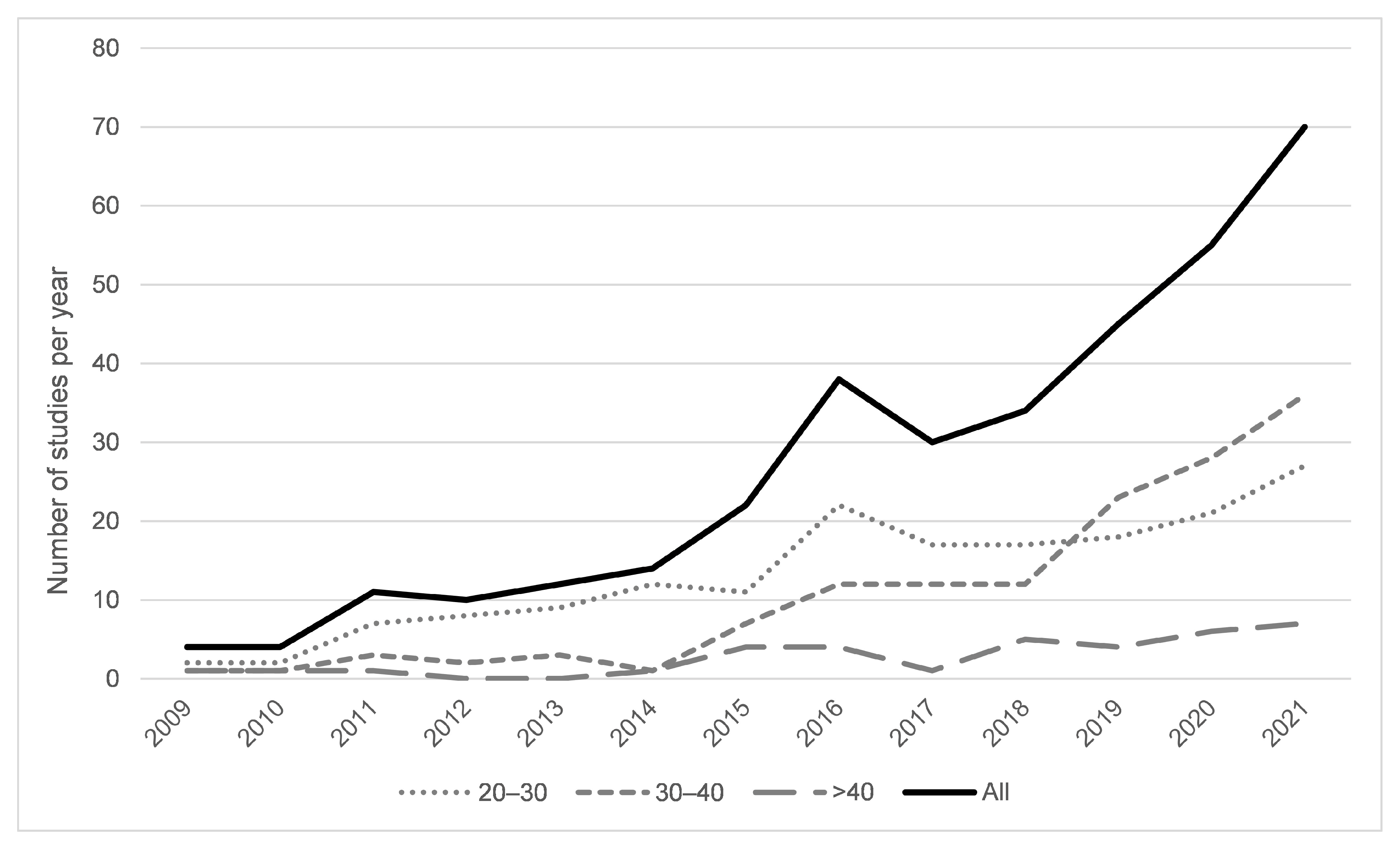
1. Introduction
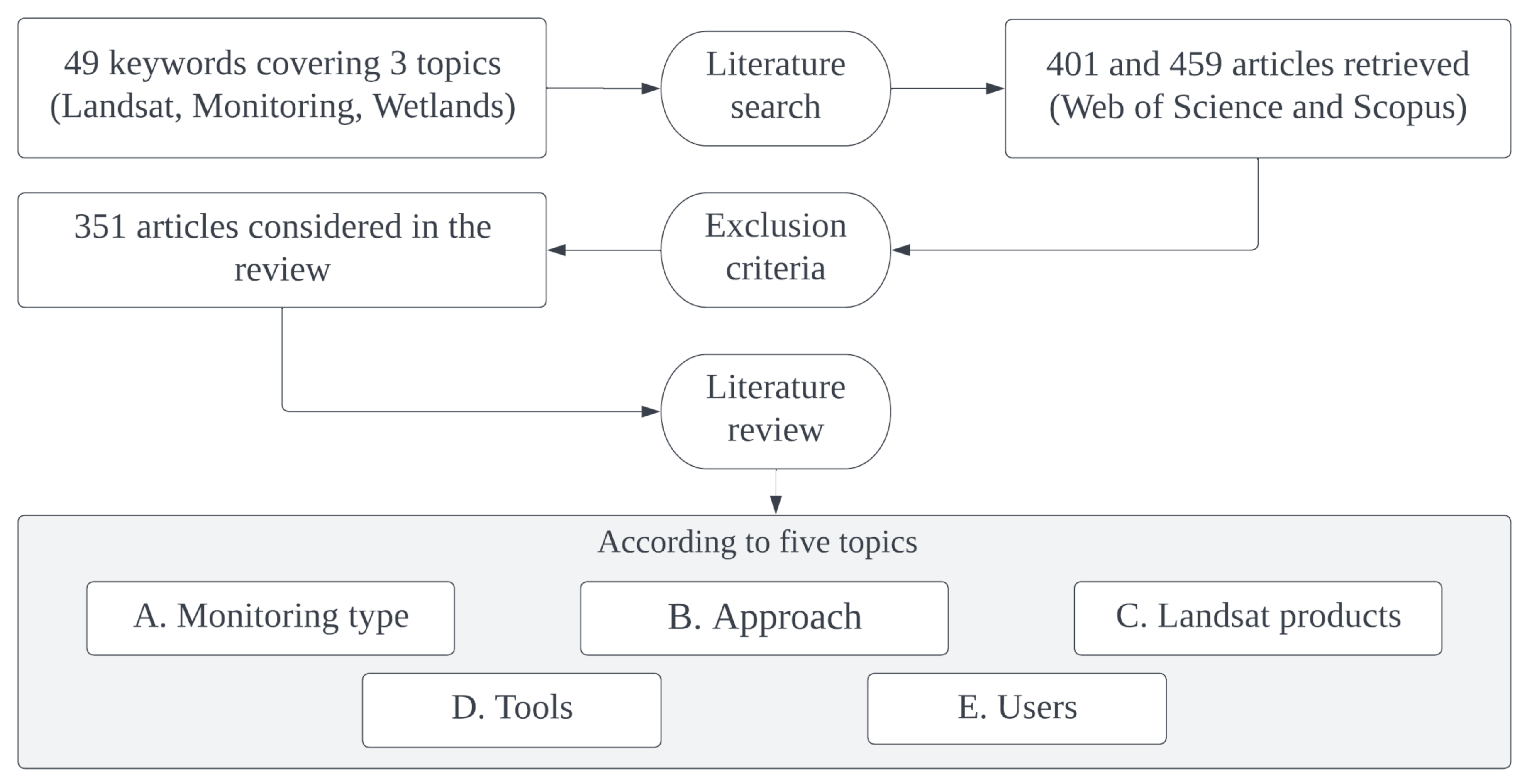
2. Methodology and Analysis
3. Long-Term Wetland Monitoring
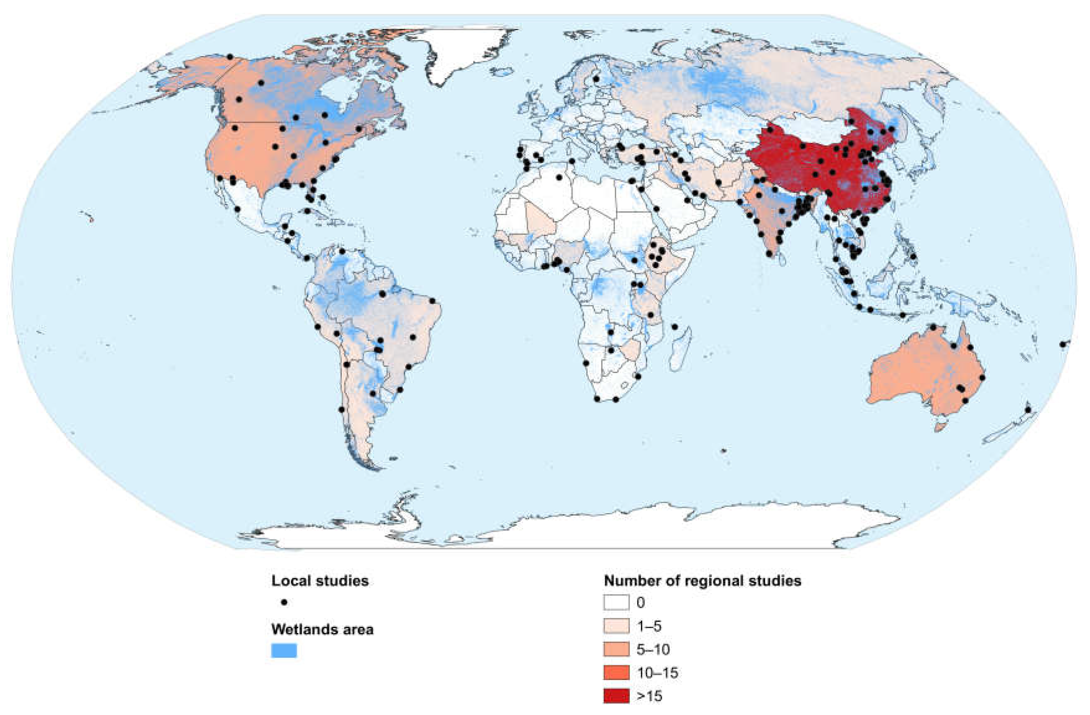
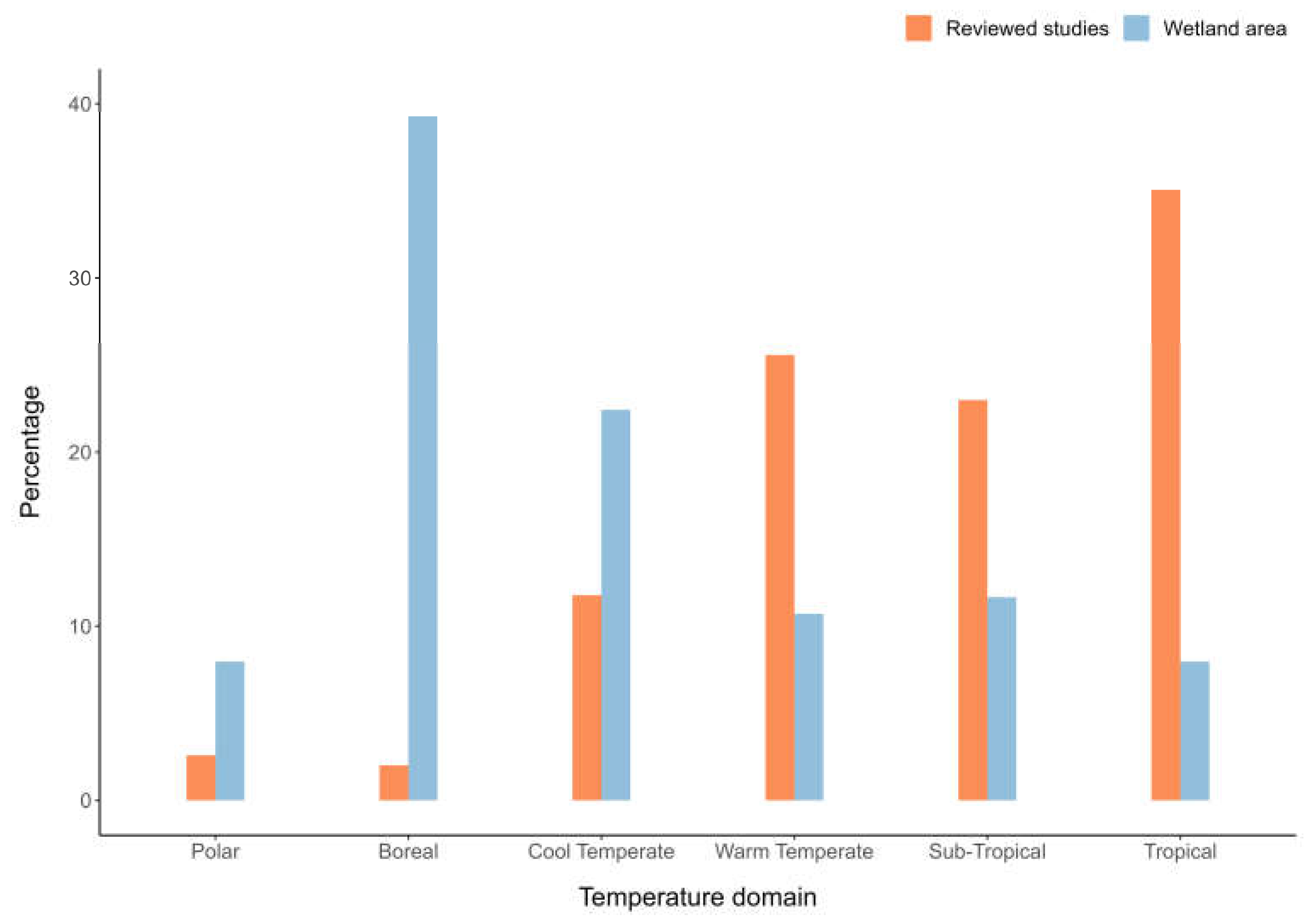
3.1. Spatial Extent and Global Distribution
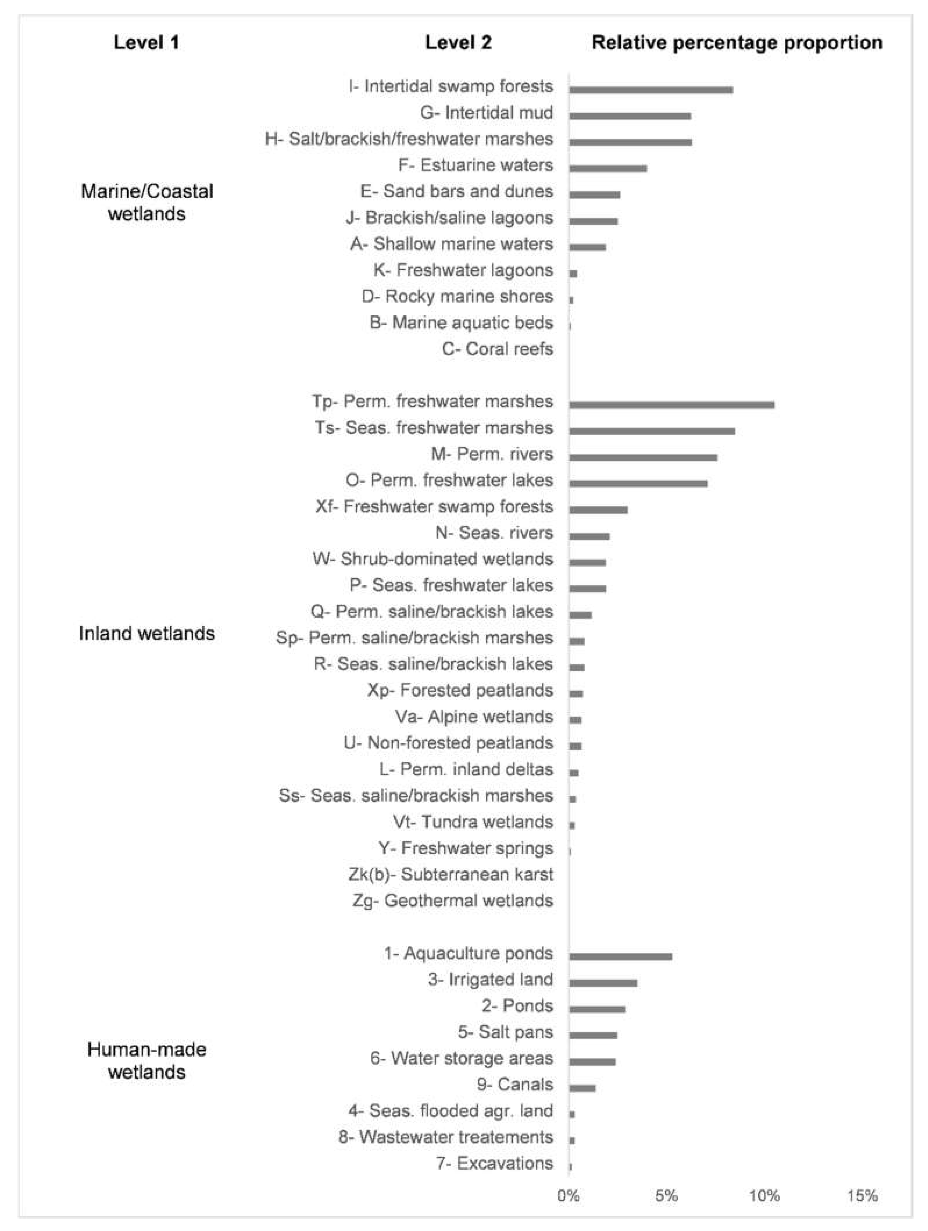
3.2. Wetland Types
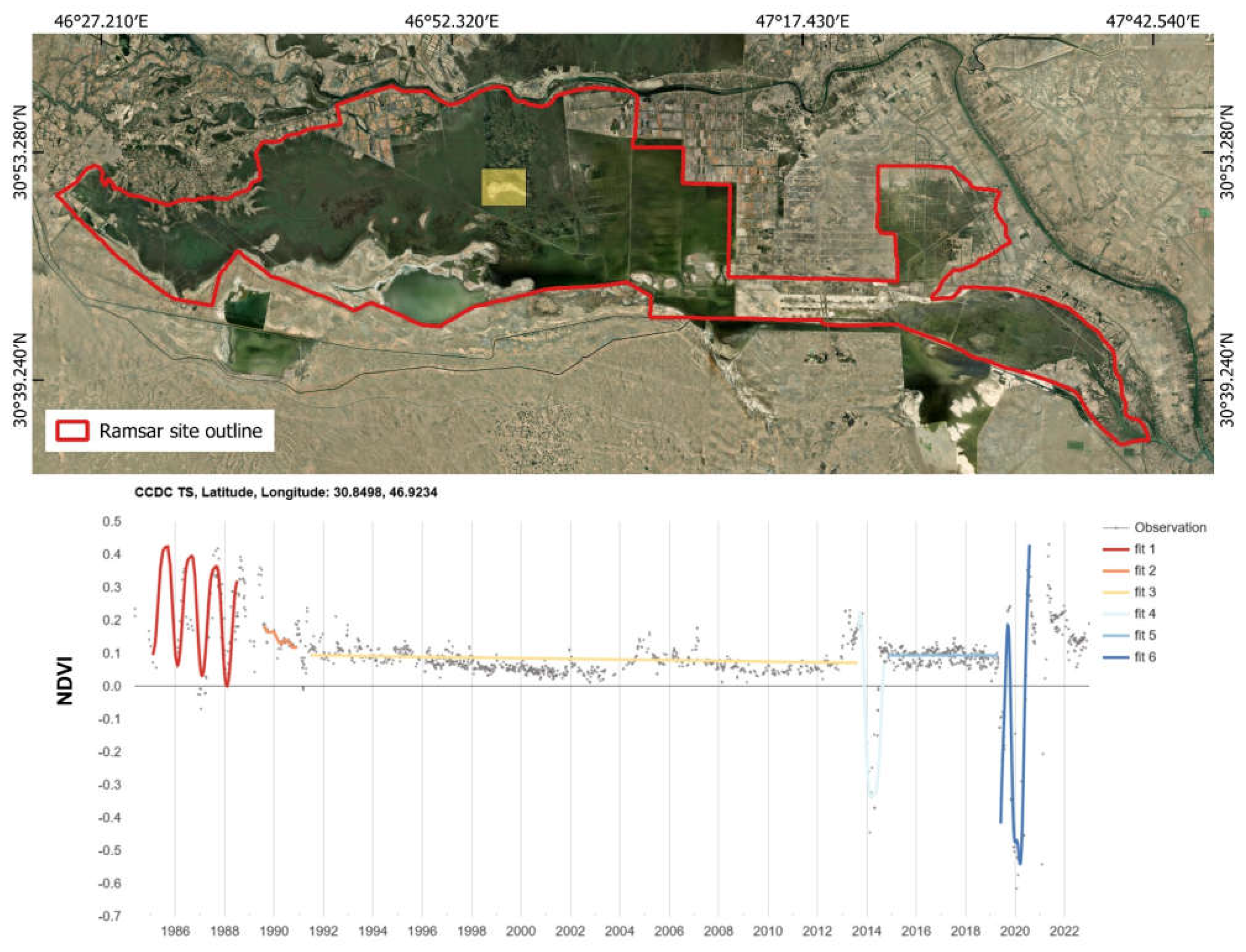
3.3. Long-Term Wetland Changes
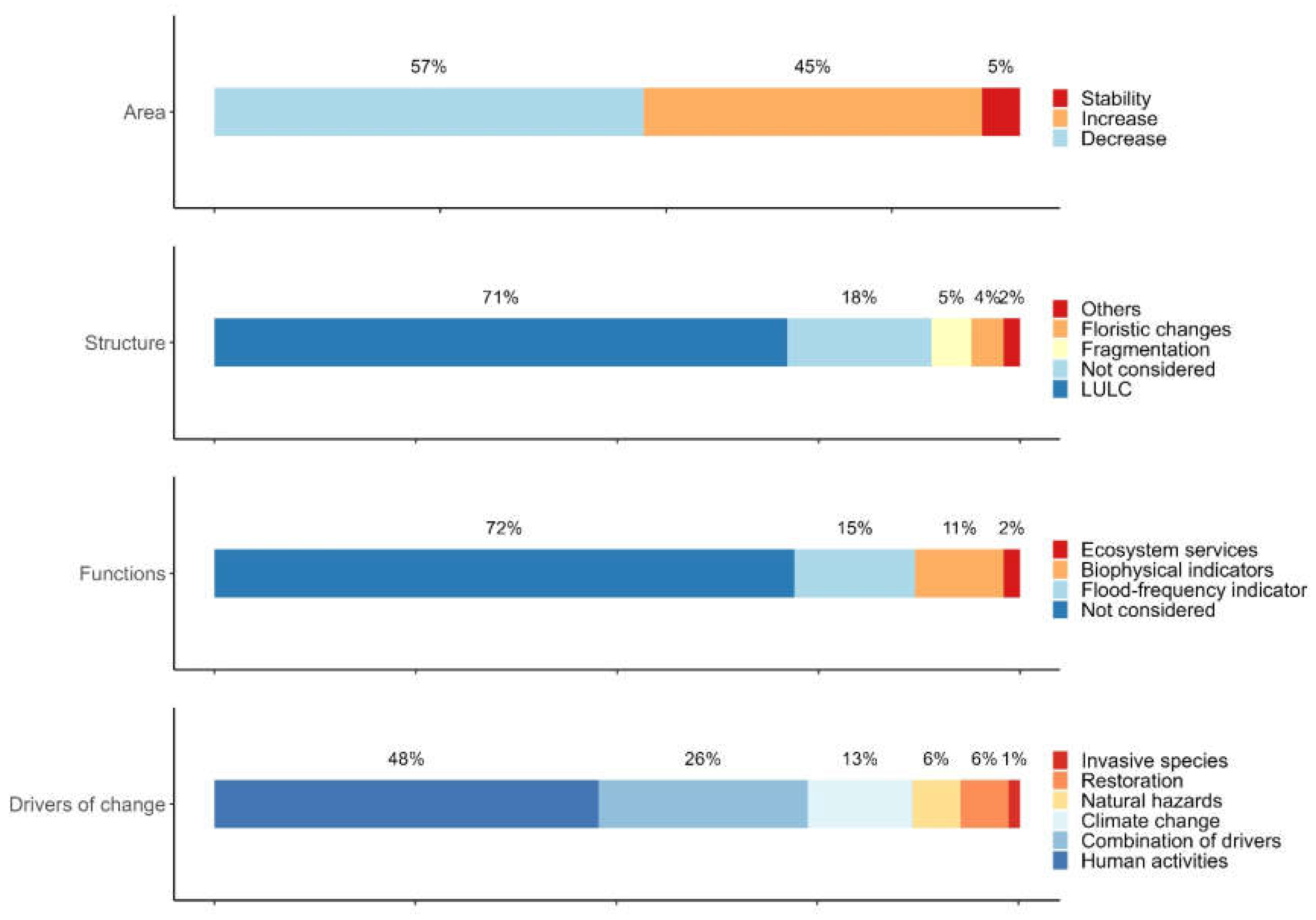
3.3.1. Area
3.3.2. Structure
3.3.3. Functions
3.4. Drivers of Change
3.4.1. Human Activities
3.4.2. Natural Hazards
3.4.3. Climate Change
3.4.4. Restoration and/or Conservation Policies
3.4.5. Invasive Species
3.4.6. Combination of Drivers of Change
4. Landsat Data Analysis
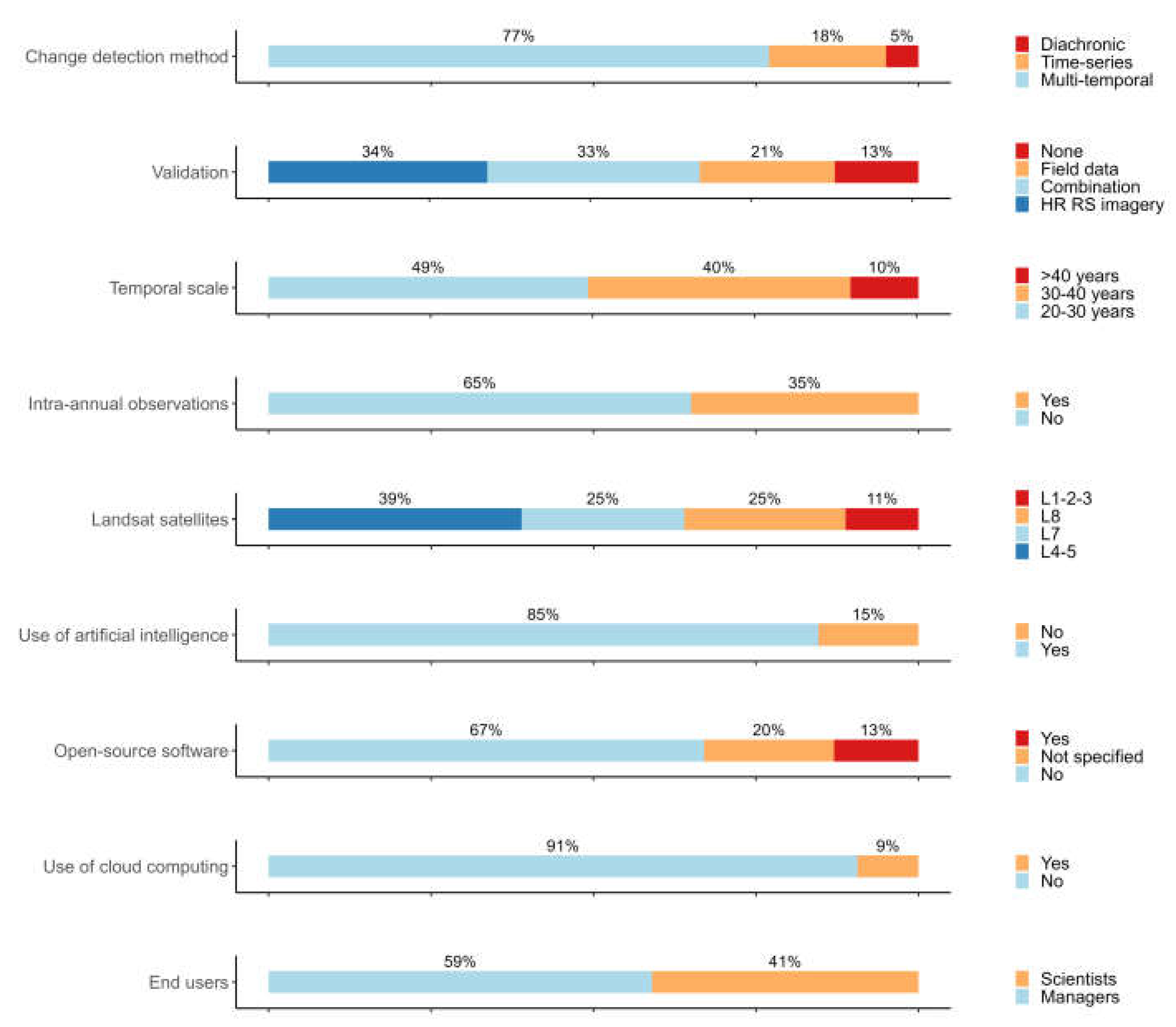
4.1. Change Detection Method
4.2. Validation
4.3. Temporal Scale of Studies
4.4. Intra-Annual Observations
4.5. Use of Landsat Sensors
4.6. Use of Artificial Intelligence
4.7. Open-Source Software
4.8. Cloud Computing
4.9. End Users
5. Progress and Recommendations
5.1. Using the Landsat Archive for the Extensive Monitoring of Wetland Extent and Type
5.2. Using the Landsat Archive to Improve the Monitoring of Wetland Areas, Structure, and Functions
5.2.1. Landsat Archive Enables the Monitoring of Wetland Area, Structure, and Functions
5.2.2. The Need for Crosswalks to Common Operational Frameworks
5.3. Extend the Monitoring Period Backwards and Forwards in Open Access
5.4. The Era of AI and Cloud Computing
5.4.1. Progress in AI and Cloud Computing Provide New Opportunities for Long-Term Wetland Monitoring
5.4.2. Bridging the Gap between Remote Sensing and Wetland Monitoring
6. Conclusions
Supplementary Materials
Author Contributions
Funding
Data Availability Statement
Acknowledgments
Conflicts of Interest
References
- Xu, X.; Chen, M.; Yang, G.; Jiang, B.; Zhang, J. Wetland Ecosystem Services Research: A Critical Review. Glob. Ecol. Conserv. 2020, 22, e01027. [Google Scholar] [CrossRef]
- Moomaw, W.R.; Chmura, G.L.; Davies, G.T.; Finlayson, C.M.; Middleton, B.A.; Natali, S.M.; Perry, J.E.; Roulet, N.; Sutton-Grier, A.E. Wetlands In a Changing Climate: Science, Policy and Management. Wetlands 2018, 38, 183–205. [Google Scholar] [CrossRef]
- Davidson, N.C.; Finlayson, C.M. Extent, Regional Distribution and Changes in Area of Different Classes of Wetland. Mar. Freshw. Res. 2018, 69, 1525–1533. [Google Scholar] [CrossRef]
- Rebelo, L.-M.; Finlayson, C.M.; Strauch, A.; Rosenqvist, A.; Perennou, C.; Tottrup, C.; Hilarides, L.; Paganini, M.; Wielaard, N.; Siegert, F. The Use of Earth Observation for Wetland Inventory, Assessment and Monitoring; Ramsar Technical Report; Ramsar Convention Secretariat: Gland, Switzerland, 2018. [Google Scholar]
- Finlayson, C.M.; Gardner, R.C. Ten Key Issues from the Global Wetland Outlook for Decision Makers. Mar. Freshw. Res. 2020, 72, 301–310. [Google Scholar] [CrossRef]
- Rebelo, A.J.; Scheunders, P.; Esler, K.J.; Meire, P. Detecting, Mapping and Classifying Wetland Fragments at a Landscape Scale. Remote Sens. Appl. Soc. Environ. 2017, 8, 212–223. [Google Scholar] [CrossRef]
- Mahdavi, S.; Salehi, B.; Granger, J.; Amani, M.; Brisco, B.; Huang, W. Remote Sensing for Wetland Classification: A Comprehensive Review. GIScience Remote Sens. 2018, 55, 623–658. [Google Scholar] [CrossRef]
- Gallant, A.L. The Challenges of Remote Monitoring of Wetlands. Remote Sens. 2015, 7, 10938–10950. [Google Scholar] [CrossRef]
- Strauch, A.; Bunting, P.; Campbell, J.; Cornish, N.; Eberle, J.; Fatoyinbo, T.; Franke, J.; Hentze, K.; Lagomasino, D.; Lucas, R.; et al. The Fate of Wetlands. In Earth Observation Applications and Global Policy Frameworks; American Geophysical Union (AGU): Washington, DC, USA, 2022; pp. 85–104. ISBN 978-1-119-53678-9. [Google Scholar]
- Mcowen, C.J.; Weatherdon, L.V.; Bochove, J.-W.V.; Sullivan, E.; Blyth, S.; Zockler, C.; Stanwell-Smith, D.; Kingston, N.; Martin, C.S.; Spalding, M.; et al. A Global Map of Saltmarshes. Biodivers. Data J. 2017, 5, e11764. [Google Scholar] [CrossRef]
- Xu, J.; Morris, P.J.; Liu, J.; Holden, J. PEATMAP: Refining Estimates of Global Peatland Distribution Based on a Meta-Analysis. CATENA 2018, 160, 134–140. [Google Scholar] [CrossRef]
- Wulder, M.A.; Roy, D.P.; Radeloff, V.C.; Loveland, T.R.; Anderson, M.C.; Johnson, D.M.; Healey, S.; Zhu, Z.; Scambos, T.A.; Pahlevan, N. Fifty Years of Landsat Science and Impacts. Remote Sens. Environ. 2022, 280, 113195. [Google Scholar] [CrossRef]
- Dwyer, J.L.; Roy, D.P.; Sauer, B.; Jenkerson, C.B.; Zhang, H.K.; Lymburner, L. Analysis Ready Data: Enabling Analysis of the Landsat Archive. Remote Sens. 2018, 10, 1363. [Google Scholar] [CrossRef]
- Hemati, M.; Hasanlou, M.; Mahdianpari, M.; Mohammadimanesh, F. A Systematic Review of Landsat Data for Change Detection Applications: 50 Years of Monitoring the Earth. Remote Sens. 2021, 13, 2869. [Google Scholar] [CrossRef]
- Wulder, M.A.; White, J.C.; Loveland, T.R.; Woodcock, C.E.; Belward, A.S.; Cohen, W.B.; Fosnight, E.A.; Shaw, J.; Masek, J.G.; Roy, D.P. The Global Landsat Archive: Status, Consolidation, and Direction. Remote Sens. Environ. 2016, 185, 271–283. [Google Scholar] [CrossRef]
- Ramsar Convention Secretariat. The Ramsar Convention Manual: A Guide to the Convention on Wetlands (Ramsar, Iran, 1971); Ramsar Convention Secretariat: Gland, Switzerland, 2006. [Google Scholar]
- Moher, D.; Liberati, A.; Tetzlaff, J.; Altman, D.G.; PRISMA Group. Preferred Reporting Items for Systematic Reviews and Meta-Analyses: The PRISMA Statement. Ann. Intern. Med. 2009, 151, 264–269. [Google Scholar] [CrossRef]
- Skidmore, A.K.; Coops, N.C.; Neinavaz, E.; Ali, A.; Schaepman, M.E.; Paganini, M.; Kissling, W.D.; Vihervaara, P.; Darvishzadeh, R.; Feilhauer, H.; et al. Priority List of Biodiversity Metrics to Observe from Space. Nat. Ecol. Evol. 2021, 5, 896–906. [Google Scholar] [CrossRef]
- Bojinski, S.; Verstraete, M.; Peterson, T.C.; Richter, C.; Simmons, A.; Zemp, M. The Concept of Essential Climate Variables in Support of Climate Research, Applications, and Policy. Bull. Am. Meteorol. Soc. 2014, 95, 1431–1443. [Google Scholar] [CrossRef]
- Mahdianpari, M.; Granger, J.E.; Mohammadimanesh, F.; Salehi, B.; Brisco, B.; Homayouni, S.; Gill, E.; Huberty, B.; Lang, M. Meta-Analysis of Wetland Classification Using Remote Sensing: A Systematic Review of a 40-Year Trend in North America. Remote Sens. 2020, 12, 1882. [Google Scholar] [CrossRef]
- Husson, F.; Le, S.; Pagès, J. Exploratory Multivariate Analysis by Example Using R; CRC Press: Boca Raton, FL, USA, 2017; ISBN 978-1-315-30186-0. [Google Scholar]
- R Core Team. A Language and Environment for Statistical Computing. R Foundation for Statistical Computing: Vienna, Austria. 2021. Available online: https://cran.r-project.org/ (accessed on 1 November 2022).
- Lê, S.; Josse, J.; Husson, F. FactoMineR: A Package for Multivariate Analysis. J. Stat. Softw. 2008, 25, 1–18. [Google Scholar] [CrossRef]
- Dahl, T.E. Remote Sensing as a Tool for Monitoring Wetland Habitat Change. In Monitoring Science and Technology Symposium: Unifying Knowledge for Sustainability in the Western Hemisphere, Proceedings RMRS-P-42CD, Fort Collins, CO, USA; Aguirre-Bravo, C., Pellicane, P.J., Burns, D.P., Draggan, S., Eds.; Department of Agriculture, Forest Service, Rocky Mountain Research Station: Ogden, UT, USA, 2006; 990p. [Google Scholar]
- Ju, J.; Masek, J.G. The Vegetation Greenness Trend in Canada and US Alaska from 1984–2012 Landsat Data. Remote Sens. Environ. 2016, 176, 1–16. [Google Scholar] [CrossRef]
- Cavanaugh, K.C.; Osland, M.J.; Bardou, R.; Hinojosa-Arango, G.; López-Vivas, J.M.; Parker, J.D.; Rovai, A.S.; Morueta-Holme, N. Sensitivity of Mangrove Range Limits to Climate Variability. Glob. Ecol. Biogeogr. 2018, 27, 925–935. [Google Scholar] [CrossRef]
- Laengner, M.L.; Siteur, K.; van der Wal, D. Trends in the Seaward Extent of Saltmarshes across Europe from Long-Term Satellite Data. Remote Sens. 2019, 11, 1653. [Google Scholar] [CrossRef]
- Schwatke, C.; Scherer, D.; Dettmering, D. Automated Extraction of Consistent Time-Variable Water Surfaces of Lakes and Reservoirs Based on Landsat and Sentinel-2. Remote Sens. 2019, 11, 1010. [Google Scholar] [CrossRef]
- Tootchi, A.; Jost, A.; Ducharne, A. Multi-Source Global Wetland Maps Combining Surface Water Imagery and Groundwater Constraints. Hydrol. Earth Syst. Sci. Discuss. 2019, 11, 189–220. [Google Scholar] [CrossRef]
- Sayre, R.; Karagulle, D.; Frye, C.; Boucher, T.; Wolff, N.H.; Breyer, S.; Wright, D.; Martin, M.; Butler, K.; Van Graafeiland, K.; et al. An Assessment of the Representation of Ecosystems in Global Protected Areas Using New Maps of World Climate Regions and World Ecosystems. Glob. Ecol. Conserv. 2020, 21, e00860. [Google Scholar] [CrossRef]
- Lopes, C.L.; Mendes, R.; Caçador, I.; Dias, J.M. Evaluation of Long-Term Estuarine Vegetation Changes through Landsat Imagery. Sci. Total Environ. 2019, 653, 512–522. [Google Scholar] [CrossRef]
- Pirali Zefrehei, A.R.; Fallah, M.; Hedayati, A. Applying Remote Sensing Techniques to Changes of Water Body and Aquatic Plants in Anzali International Wetland (1985–2018). Theor. Appl. Ecol. 2021, 1, 65–72. [Google Scholar] [CrossRef]
- Chouari, W. Wetland Land Cover Change Detection Using Multitemporal Landsat Data: A Case Study of the Al-Asfar Wetland, Kingdom of Saudi Arabia. Arab. J. Geosci. 2021, 14, 523. [Google Scholar] [CrossRef]
- Hiernaux, P.; Turner, M.D.; Eggen, M.; Marie, J.; Haywood, M. Resilience of Wetland Vegetation to Recurrent Drought in the Inland Niger Delta of Mali from 1982 to 2014. Wetl. Ecol. Manag. 2021, 29, 945–967. [Google Scholar] [CrossRef]
- Wells, A.F.; Frost, G.V.; Macander, M.J.; Jorgenson, M.T.; Roth, J.E.; Davis, W.A.; Pullman, E.R. Integrated Terrain Unit Mapping on the Beaufort Coastal Plain, North Slope, Alaska, USA. Landsc. Ecol. 2021, 36, 549–579. [Google Scholar] [CrossRef]
- Dang, A.T.; Kumar, L.; Reid, M.; Nguyen, H. Remote Sensing Approach for Monitoring Coastal Wetland in the Mekong Delta, Vietnam: Change Trends and Their Driving Forces. Remote Sens. 2021, 13, 3359. [Google Scholar] [CrossRef]
- Carney, J.; Gillespie, T.W.; Rosomoff, R. Assessing Forest Change in a Priority West African Mangrove Ecosystem: 1986–2010. Geoforum 2014, 53, 126–135. [Google Scholar] [CrossRef]
- Cherrington, E.A.; Griffin, R.E.; Anderson, E.R.; Hernandez Sandoval, B.E.; Flores-Anderson, A.I.; Muench, R.E.; Markert, K.N.; Adams, E.C.; Limaye, A.S.; Irwin, D.E. Use of Public Earth Observation Data for Tracking Progress in Sustainable Management of Coastal Forest Ecosystems in Belize, Central America. Remote Sens. Environ. 2020, 245, 111798. [Google Scholar] [CrossRef]
- Mabwoga, S.O.; Thukral, A.K. Characterization of Change in the Harike Wetland, a Ramsar Site in India, Using Landsat Satellite Data. SpringerPlus 2014, 3, 576. [Google Scholar] [CrossRef]
- Nguyen, H.-H.; McAlpine, C.; Pullar, D.; Johansen, K.; Duke, N.C. The Relationship of Spatial–Temporal Changes in Fringe Mangrove Extent and Adjacent Land-Use: Case Study of Kien Giang Coast, Vietnam. Ocean Coast. Manag. 2013, 76, 12–22. [Google Scholar] [CrossRef]
- Rakotomavo, A.; Fromard, F. Dynamics of Mangrove Forests in the Mangoky River Delta, Madagascar, under the Influence of Natural and Human Factors. For. Ecol. Manag. 2010, 259, 1161–1169. [Google Scholar] [CrossRef]
- Dipson, P.T.; Chithra, S.V.; Amarnath, A.; Smitha, S.V.; Harindranathan Nair, M.V.; Shahin, A. Spatial Changes of Estuary in Ernakulam District, Southern India for Last Seven Decades, Using Multi-Temporal Satellite Data. J. Environ. Manag. 2015, 148, 134–142. [Google Scholar] [CrossRef]
- Koshale, J.P.; Mahato, A. Spatio-Temporal Change Detection and Its Impact on the Waterbodies by Monitoring LU/LC Dynamics-A Case Study from Holy City of Ratanpur, Chhattisgarh, India. Nat. Environ. Pollut. Technol. 2020, 19, 1801–1810. [Google Scholar] [CrossRef]
- Tope-Ajayi, O.O.; Adedeji, O.H.; Adeofun, C.O.; Awokola, S.O. Land Use Change Assessment, Prediction Using Remote Sensing, and Gis Aided Markov Chain Modelling at Eleyele Wetland Area, Nigeria. J. Settl. Spat. Plan. 2016, 7, 51–63. [Google Scholar]
- Kabiri, S.; Allen, M.; Okuonzia, J.T.; Akello, B.; Ssabaganzi, R.; Mubiru, D. Detecting Level of Wetland Encroachment for Urban Agriculture in Uganda Using Hyper-Temporal Remote Sensing. AAS Open Res. 2020, 3, 18. [Google Scholar] [CrossRef]
- Campbell, T.; Lantz, T.; Fraser, R. Impacts of Climate Change and Intensive Lesser Snow Goose (Chen Caerulescens Caerulescens) Activity on Surface Water in High Arctic Pond Complexes. Remote Sens. 2018, 10, 1892. [Google Scholar] [CrossRef]
- Hu, L.; Li, W.; Xu, B. Monitoring Mangrove Forest Change in China from 1990 to 2015 Using Landsat-Derived Spectral-Temporal Variability Metrics. Int. J. Appl. Earth Obs. Geoinf. 2018, 73, 88–98. [Google Scholar] [CrossRef]
- Son, N.T.; Thanh, B.X.; Da, C.T. Monitoring Mangrove Forest Changes from Multi-Temporal Landsat Data in Can Gio Biosphere Reserve, Vietnam. Wetlands 2016, 36, 565–576. [Google Scholar] [CrossRef]
- Asbridge, E.; Lucas, R.; Ticehurst, C.; Bunting, P. Mangrove Response to Environmental Change in Australia’s Gulf of Carpentaria. Ecol. Evol. 2016, 6, 3523–3539. [Google Scholar] [CrossRef] [PubMed]
- Dangles, O.; Rabatel, A.; Kraemer, M.; Zeballos, G.; Soruco, A.; Jacobsen, D.; Anthelme, F. Ecosystem Sentinels for Climate Change? Evidence of Wetland Cover Changes over the Last 30 Years in the Tropical Andes. PLoS ONE 2017, 12, e0175814. [Google Scholar] [CrossRef]
- Veettil, B.K.; Florêncio de Souza, S.; Simões, J.C.; Ruiz Pereira, S.F. Decadal Evolution of Glaciers and Glacial Lakes in the Apolobamba–Carabaya Region, Tropical Andes (Bolivia–Peru). Geogr. Ann. Ser. Phys. Geogr. 2017, 99, 193–206. [Google Scholar] [CrossRef]
- Islam, M.d.M.; Borgqvist, H.; Kumar, L. Monitoring Mangrove Forest Landcover Changes in the Coastline of Bangladesh from 1976 to 2015. Geocarto Int. 2018, 34, 1458–1476. [Google Scholar] [CrossRef]
- Talukdar, G.; Sarma, A.K.; Bhattacharjya, R.K. Mapping Agricultural Activities and Their Temporal Variations in the Riverine Ecosystem of the Brahmaputra River Using Geospatial Techniques. Remote Sens. Appl. Soc. Environ. 2020, 20, 100423. [Google Scholar] [CrossRef]
- Tiné, M.; Perez, L.; Molowny-Horas, R.; Darveau, M. Hybrid Spatiotemporal Simulation of Future Changes in Open Wetlands: A Study of the Abitibi-Témiscamingue Region, Québec, Canada. Int. J. Appl. Earth Obs. Geoinf. 2019, 74, 302–313. [Google Scholar] [CrossRef]
- Paul, S.; Pal, S. Exploring Wetland Transformations in Moribund Deltaic Parts of India. Geocarto Int. 2020, 35, 1873–1894. [Google Scholar] [CrossRef]
- Krapu, C.; Kumar, M.; Borsuk, M. Identifying Wetland Consolidation Using Remote Sensing in the North Dakota Prairie Pothole Region. Water Resour. Res. 2018, 54, 7478–7494. [Google Scholar] [CrossRef]
- Tian, Y.; Luo, L.; Mao, D.; Wang, Z.; Li, L.; Liang, J. Using Landsat Images to Quantify Different Human Threats to the Shuangtai Estuary Ramsar Site, China. Ocean Coast. Manag. 2017, 135, 56–64. [Google Scholar] [CrossRef]
- Ekumah, B.; Armah, F.A.; Afrifa, E.K.A.; Aheto, D.W.; Odoi, J.O.; Afitiri, A.-R. Geospatial Assessment of Ecosystem Health of Coastal Urban Wetlands in Ghana. Ocean Coast. Manag. 2020, 193, 105226. [Google Scholar] [CrossRef]
- Qiu, P.; Wu, N.; Luo, P.; Wang, Z.; Li, M. Analysis of Dynamics and Driving Factors of Wetland Landscape in Zoige, Eastern Qinghai-Tibetan Plateau. J. Mt. Sci. 2009, 6, 42–55. [Google Scholar] [CrossRef]
- Bishop-Taylor, R.; Tulbure, M.G.; Broich, M. Surface-water Dynamics and Land Use Influence Landscape Connectivity across a Major Dryland Region. Ecol. Appl. 2017, 27, 1124–1137. [Google Scholar] [CrossRef]
- Gilani, H.; Naz, H.I.; Arshad, M.; Nazim, K.; Akram, U.; Abrar, A.; Asif, M. Evaluating Mangrove Conservation and Sustainability through Spatiotemporal (1990–2020) Mangrove Cover Change Analysis in Pakistan. Estuar. Coast. Shelf Sci. 2021, 249, 107128. [Google Scholar] [CrossRef]
- O’Donnell, J.P.R.; Schalles, J.F. Examination of Abiotic Drivers and Their Influence on Spartina Alterniflora Biomass over a Twenty-Eight Year Period Using Landsat 5 TM Satellite Imagery of the Central Georgia Coast. Remote Sens. 2016, 8, 477. [Google Scholar] [CrossRef]
- Lucas, R.; Van De Kerchove, R.; Otero, V.; Lagomasino, D.; Fatoyinbo, L.; Omar, H.; Satyanarayana, B.; Dahdouh-Guebas, F. Structural Characterisation of Mangrove Forests Achieved through Combining Multiple Sources of Remote Sensing Data. Remote Sens. Environ. 2020, 237, 111543. [Google Scholar] [CrossRef]
- Ghosh, M.; Kumar, L.; Roy, C. Climate Variability and Mangrove Cover Dynamics at Species Level in the Sundarbans, Bangladesh. Sustainability 2017, 9, 805. [Google Scholar] [CrossRef]
- Lap, Q.K.; Luong, V.N.; Hong, X.T.; Tu, T.T.; Thanh, K.T.P. Evaluation of mangrove rehabilitation after being destroyed by chemical warfare using remote sensing technology: A case study in can gio mangrove forest in mekong delta, southern vietnam. Appl. Ecol. Environ. Res. 2021, 19, 3897–3930. [Google Scholar] [CrossRef]
- Lymburner, L.; Bunting, P.; Lucas, R.; Scarth, P.; Alam, I.; Phillips, C.; Ticehurst, C.; Held, A. Mapping the Multi-Decadal Mangrove Dynamics of the Australian Coastline. Remote Sens. Environ. 2020, 238, 111185. [Google Scholar] [CrossRef]
- Gayol, M.P.; Morandeira, N.S.; Kandus, P. Dynamics of Shallow Lake Cover Types in Relation to Paraná River Flood Pulses: Assessment with Multitemporal Landsat Data. Hydrobiologia 2019, 833, 9–24. [Google Scholar] [CrossRef]
- Amani, M.; Mahdavi, S.; Kakooei, M.; Ghorbanian, A.; Brisco, B.; DeLancey, E.R.; Toure, S.; Reyes, E.L. Wetland Change Analysis in Alberta, Canada Using Four Decades of Landsat Imagery. IEEE J. Sel. Top. Appl. Earth Obs. Remote Sens. 2021, 14, 10314–10335. [Google Scholar] [CrossRef]
- Dong, X.; Chen, Z. Digital Examination of Vegetation Changes in River Floodplain Wetlands Based on Remote Sensing Images: A Case Study Based on the Downstream Section of Hailar River. Forests 2021, 12, 1206. [Google Scholar] [CrossRef]
- Mondal, D.; Pal, S. Monitoring Dual-Season Hydrological Dynamics of Seasonally Flooded Wetlands in the Lower Reach of Mayurakshi River, Eastern India. Geocarto Int. 2016, 33, 225–239. [Google Scholar] [CrossRef]
- Tang, Z.; Li, Y.; Gu, Y.; Jiang, W.; Xue, Y.; Hu, Q.; LaGrange, T.; Bishop, A.; Drahota, J.; Li, R. Assessing Nebraska Playa Wetland Inundation Status during 1985–2015 Using Landsat Data and Google Earth Engine. Environ. Monit. Assess. 2016, 188, 654. [Google Scholar] [CrossRef]
- Thomas, R.F.; Kingsford, R.T.; Lu, Y.; Hunter, S.J. Landsat Mapping of Annual Inundation (1979–2006) of the Macquarie Marshes in Semi-Arid Australia. Int. J. Remote Sens. 2011, 32, 4545–4569. [Google Scholar] [CrossRef]
- Díaz-Delgado, R.; Aragonés, D.; Afán, I.; Bustamante, J. Long-Term Monitoring of the Flooding Regime and Hydroperiod of Doñana Marshes with Landsat Time Series (1974–2014). Remote Sens. 2016, 8, 775. [Google Scholar] [CrossRef]
- Cai, X.; Haile, A.T.; Magidi, J.; Mapedza, E.; Nhamo, L. Living with Floods—Household Perception and Satellite Observations in the Barotse Floodplain, Zambia. Phys. Chem. Earth Parts ABC 2017, 100, 278–286. [Google Scholar] [CrossRef]
- Mazzarino, M.; Finn, J.T. An NDVI Analysis of Vegetation Trends in an Andean Watershed. Wetl. Ecol. Manag. 2016, 24, 623–640. [Google Scholar] [CrossRef]
- Hartman, B.D.; Bookhagen, B.; Chadwick, O.A. The Effects of Check Dams and Other Erosion Control Structures on the Restoration of Andean Bofedal Ecosystems. Restor. Ecol. 2016, 24, 761–772. [Google Scholar] [CrossRef]
- Pirali Zefrehei, A.R.; Hedayati, A.; Pourmanafi, S.; Kashkooli, O.B.; Ghorbani, R. Monitoring Spatiotemporal Variability of Water Quality Parameters Using Landsat Imagery in Choghakhor International Wetland during the Last 32 Years. Ann. Limnol. Int. J. Limnol. 2020, 56, 6. [Google Scholar] [CrossRef]
- Ho, J.C.; Stumpf, R.P.; Bridgeman, T.B.; Michalak, A.M. Using Landsat to Extend the Historical Record of Lacustrine Phytoplankton Blooms: A Lake Erie Case Study. Remote Sens. Environ. 2017, 191, 273–285. [Google Scholar] [CrossRef]
- Alademomi, A.S.; Okolie, C.J.; Daramola, O.E.; Agboola, R.O.; Salami, T.J. Assessing the Relationship of LST, NDVI and EVI with Land Cover Changes in the Lagos Lagoon Environment. Quaest. Geogr. 2020, 39, 87–109. [Google Scholar] [CrossRef]
- Avtar, R.; Navia, M.; Sassen, J.; Fujii, M. Impacts of Changes in Mangrove Ecosystems in the Ba and Rewa Deltas, Fiji Using Multi-Temporal Landsat Data and Social Survey. Coast. Eng. J. 2021, 63, 386–407. [Google Scholar] [CrossRef]
- Zhao, G.; Ye, S.; Li, G.; Yu, X.; McClellan, S.A. Soil Organic Carbon Storage Changes in Coastal Wetlands of the Liaohe Delta, China, Based on Landscape Patterns. Estuaries Coasts 2017, 40, 967–976. [Google Scholar] [CrossRef]
- Duncan, C.; Böhm, M.; Turvey, S.T. Identifying the Possibilities and Pitfalls of Conducting IUCN Red List Assessments from Remotely Sensed Habitat Information Based on Insights from Poorly Known Cuban Mammals. Conserv. Biol. 2021, 35, 1598–1614. [Google Scholar] [CrossRef]
- Ashournejad, Q.; Amiraslani, F.; Moghadam, M.K.; Toomanian, A. Assessing the Changes of Mangrove Ecosystem Services Value in the Pars Special Economic Energy Zone. Ocean Coast. Manag. 2019, 179, 104838. [Google Scholar] [CrossRef]
- Yushanjiang, A.; Zhang, F.; Kung, H.; Li, Z. Spatial–Temporal Variation of Ecosystem Service Values in Ebinur Lake Wetland National Natural Reserve from 1972 to 2016, Xinjiang, Arid Region of China. Environ. Earth Sci. 2018, 77, 586. [Google Scholar] [CrossRef]
- Blanchette, M.; Rousseau, A.N.; Poulin, M. Mapping Wetlands and Land Cover Change with Landsat Archives: The Added Value of Geomorphologic Data: Cartographie de La Dynamique Spatio-Temporelle Des Milieux Humides à Partir d’archives Landsat: La Valeur Ajoutée de Données Géomorphologiques. Can. J. Remote Sens. 2018, 44, 337–356. [Google Scholar] [CrossRef]
- Mialhe, F.; Gunnell, Y.; Navratil, O.; Choi, D.; Sovann, C.; Lejot, J.; Gaudou, B.; Se, B.; Landon, N. Spatial Growth of Phnom Penh, Cambodia (1973–2015): Patterns, Rates, and Socio-Ecological Consequences. Land Use Policy 2019, 87, 104061. [Google Scholar] [CrossRef]
- Fickas, K.C.; Cohen, W.B.; Yang, Z. Landsat-Based Monitoring of Annual Wetland Change in the Willamette Valley of Oregon, USA from 1972 to 2012. Wetl. Ecol. Manag. 2016, 24, 73–92. [Google Scholar] [CrossRef]
- Wang, P.; Numbere, A.O.; Camilo, G.R. Long-Term Changes in Mangrove Landscape of the Niger River Delta, Nigeria. Am. J. Environ. Sci. 2016, 12, 248–259. [Google Scholar] [CrossRef]
- Ding, X.; Shan, X.; Chen, Y.; Li, M.; Li, J.; Jin, X. Variations in Fish Habitat Fragmentation Caused by Marine Reclamation Activities in the Bohai Coastal Region, China. Ocean Coast. Manag. 2020, 184, 105038. [Google Scholar] [CrossRef]
- Xie, C.; Huang, X.; Mu, H.; Yin, W. Impacts of Land-Use Changes on the Lakes across the Yangtze Floodplain in China. Environ. Sci. Technol. 2017, 51, 3669–3677. [Google Scholar] [CrossRef] [PubMed]
- Eddy, S.; Iskandar, I.; Ridho, M.R.; Mulyana, A. Land Cover Changes in the Air Telang Protected Forest, South Sumatra, Indonesia (1989–2013). Biodiversitas J. Biol. Divers. 2017, 18, 1538–1545. [Google Scholar] [CrossRef]
- Hong, H.T.C.; Avtar, R.; Fujii, M. Monitoring Changes in Land Use and Distribution of Mangroves in the Southeastern Part of the Mekong River Delta, Vietnam. Trop. Ecol. 2019, 60, 552–565. [Google Scholar] [CrossRef]
- Jayanthi, M.; Thirumurthy, S.; Muralidhar, M.; Ravichandran, P. Impact of Shrimp Aquaculture Development on Important Ecosystems in India. Glob. Environ. Change 2018, 52, 10–21. [Google Scholar] [CrossRef]
- Masria, A.; El-Adawy, A.A.; Sarhan, T. A Holistic Evaluation of Human-Induced LULCC and Shoreline Dynamics of El-Burullus Lagoon through Remote Sensing Techniques. Innov. Infrastruct. Solut. 2020, 5, 83. [Google Scholar] [CrossRef]
- Gao, Z.; Guo, H.; Li, S.; Wang, J.; Ye, H.; Han, S.; Cao, W. Remote Sensing of Wetland Evolution in Predicting Shallow Groundwater Arsenic Distribution in Two Typical Inland Basins. Sci. Total Environ. 2022, 806, 150496. [Google Scholar] [CrossRef]
- Karim, M.; Maanan, M.; Maanan, M.; Rhinane, H.; Rueff, H.; Baidder, L. Assessment of Water Body Change and Sedimentation Rate in Moulay Bousselham Wetland, Morocco, Using Geospatial Technologies. Int. J. Sediment Res. 2019, 34, 65–72. [Google Scholar] [CrossRef]
- Villate Daza, D.A.; Sánchez Moreno, H.; Portz, L.; Portantiolo Manzolli, R.; Bolívar-Anillo, H.J.; Anfuso, G. Mangrove Forests Evolution and Threats in the Caribbean Sea of Colombia. Water 2020, 12, 1113. [Google Scholar] [CrossRef]
- Ablat, X.; Liu, G.; Liu, Q.; Huang, C. Application of Landsat Derived Indices and Hydrological Alteration Matrices to Quantify the Response of Floodplain Wetlands to River Hydrology in Arid Regions Based on Different Dam Operation Strategies. Sci. Total Environ. 2019, 688, 1389–1404. [Google Scholar] [CrossRef]
- Zheng, L.; Xu, J.; Tan, Z.; Xu, G.; Xu, L.; Wang, X. A Thirty-Year Landsat Study Reveals Changes to a River-Lake Junction Ecosystem after Implementation of the Three Gorges Dam. J. Hydrol. 2020, 589, 125185. [Google Scholar] [CrossRef]
- Fitoka, E.; Tompoulidou, M.; Hatziiordanou, L.; Apostolakis, A.; Höfer, R.; Weise, K.; Ververis, C. Water-Related Ecosystems’ Mapping and Assessment Based on Remote Sensing Techniques and Geospatial Analysis: The SWOS National Service Case of the Greek Ramsar Sites and Their Catchments. Remote Sens. Environ. 2020, 245, 111795. [Google Scholar] [CrossRef]
- Darmawan, S.; Sari, D.K.; Wikantika, K.; Tridawati, A.; Hernawati, R.; Sedu, M.K. Identification Before-after Forest Fire and Prediction of Mangrove Forest Based on Markov-Cellular Automata in Part of Sembilang National Park, Banyuasin, South Sumatra, Indonesia. Remote Sens. 2020, 12, 3700. [Google Scholar] [CrossRef]
- Mexicano, L.; Glenn, E.P.; Hinojosa-Huerta, O.; Garcia-Hernandez, J.; Flessa, K.; Hinojosa-Corona, A. Long-Term Sustainability of the Hydrology and Vegetation of Cienega de Santa Clara, an Anthropogenic Wetland Created by Disposal of Agricultural Drain Water in the Delta of the Colorado River, Mexico. Ecol. Eng. 2013, 59, 111–120. [Google Scholar] [CrossRef]
- Carle, M.V.; Sasser, C.E. Productivity and Resilience: Long-Term Trends and Storm-Driven Fluctuations in the Plant Community of the Accreting Wax Lake Delta. Estuaries Coasts 2015, 39, 406–422. [Google Scholar] [CrossRef]
- Zhang, K.; Thapa, B.; Ross, M.; Gann, D. Remote Sensing of Seasonal Changes and Disturbances in Mangrove Forest: A Case Study from South Florida. Ecosphere 2016, 7, e01366. [Google Scholar] [CrossRef]
- Reza, P.Z.A.; Aliakba, H.; Saeid, P.; Omid, B.K.; Rasoul, G. Detection and Prediction of Water Body and Aquatic Plants Cover Changes of Choghakhor International Wetland, Using Landsat Imagery and the Cellular Automata–Markov Model. Contemp. Probl. Ecol. 2020, 13, 545–555. [Google Scholar] [CrossRef]
- Long, C.; Dai, Z.; Zhou, X.; Mei, X.; Mai Van, C. Mapping Mangrove Forests in the Red River Delta, Vietnam. For. Ecol. Manag. 2021, 483, 118910. [Google Scholar] [CrossRef]
- Behling, R.; Milewski, R.; Chabrillat, S. Spatiotemporal Shoreline Dynamics of Namibian Coastal Lagoons Derived by a Dense Remote Sensing Time Series Approach. Int. J. Appl. Earth Obs. Geoinf. 2018, 68, 262–271. [Google Scholar] [CrossRef]
- Jia, P.; Zhang, Y.; Xu, W.; Xia, Z.; Zhong, C.; Yin, Y. Spatio-Temporal Evolution of Coastlines of Sand-Barrier Lagoons over 26 Years through Historic Landsat Imagery in Lingshui County, Hainan Province, China. J. Coast. Conserv. 2018, 23, 817–827. [Google Scholar] [CrossRef]
- Kuleli, T.; Guneroglu, A.; Karsli, F.; Dihkan, M. Automatic Detection of Shoreline Change on Coastal Ramsar Wetlands of Turkey. Ocean Eng. 2011, 38, 1141–1149. [Google Scholar] [CrossRef]
- Banerjee, B.P.; Raval, S.; Timms, W. Evaluation of Rainfall and Wetland Water Area Variability at Thirlmere Lakes Using Landsat Time-Series Data. Int. J. Environ. Sci. Technol. 2016, 13, 1781–1792. [Google Scholar] [CrossRef]
- Dearborn, K.D.; Baltzer, J.L. Unexpected Greening in a Boreal Permafrost Peatland Undergoing Forest Loss Is Partially Attributable to Tree Species Turnover. Glob. Change Biol. 2021, 27, 2867–2882. [Google Scholar] [CrossRef]
- Pan, F.; Xie, J.; Lin, J.; Zhao, T.; Ji, Y.; Hu, Q.; Pan, X.; Wang, C.; Xi, X. Evaluation of Climate Change Impacts on Wetland Vegetation in the Dunhuang Yangguan National Nature Reserve in Northwest China Using Landsat Derived NDVI. Remote Sens. 2018, 10, 735. [Google Scholar] [CrossRef]
- Sun, C.; Fagherazzi, S.; Liu, Y. Classification Mapping of Salt Marsh Vegetation by Flexible Monthly NDVI Time-Series Using Landsat Imagery. Estuar. Coast. Shelf Sci. 2018, 213, 61–80. [Google Scholar] [CrossRef]
- Charters, L.J.; Aplin, P.; Marston, C.G.; Padfield, R.; Rengasamy, N.; Bin Dahalan, M.P.; Evers, S. Peat Swamp Forest Conservation Withstands Pervasive Land Conversion to Oil Palm Plantation in North Selangor, Malaysia. Int. J. Remote Sens. 2019, 40, 7409–7438. [Google Scholar] [CrossRef]
- Wilson, N.R.; Norman, L.M. Analysis of Vegetation Recovery Surrounding a Restored Wetland Using the Normalized Difference Infrared Index (NDII) and Normalized Difference Vegetation Index (NDVI). Int. J. Remote Sens. 2018, 39, 3243–3274. [Google Scholar] [CrossRef]
- Li, M.S.; Mao, L.J.; Shen, W.J.; Liu, S.Q.; Wei, A.S. Change and Fragmentation Trends of Zhanjiang Mangrove Forests in Southern China Using Multi-Temporal Landsat Imagery (1977–2010). Estuar. Coast. Shelf Sci. 2013, 130, 111–120. [Google Scholar] [CrossRef]
- Misra, A.; Murali, M.R.; Vethamony, P. Assessment of the Land Use/Land Cover (LU/LC) and Mangrove Changes along the Mandovi–Zuari Estuarine Complex of Goa, India. Arab. J. Geosci. 2015, 8, 267–279. [Google Scholar] [CrossRef]
- Tuholske, C.; Tane, Z.; López-Carr, D.; Roberts, D.; Cassels, S. Thirty Years of Land Use/Cover Change in the Caribbean: Assessing the Relationship between Urbanization and Mangrove Loss in Roatán, Honduras. Appl. Geogr. 2017, 88, 84–93. [Google Scholar] [CrossRef]
- Wu, Y.; Xiao, X.; Chen, B.; Ma, J.; Wang, X.; Zhang, Y.; Zhao, B.; Li, B. Tracking the Phenology and Expansion of Spartina Alterniflora Coastal Wetland by Time Series MODIS and Landsat Images. Multimed. Tools Appl. 2018, 79, 5175–5195. [Google Scholar] [CrossRef]
- Yan, D.; Li, J.; Yao, X.; Luan, Z. Quantifying the Long-Term Expansion and Dieback of Spartina Alterniflora Using Google Earth Engine and Object-Based Hierarchical Random Forest Classification. IEEE J. Sel. Top. Appl. Earth Obs. Remote Sens. 2021, 14, 9781–9793. [Google Scholar] [CrossRef]
- Marzvan, S.; Moravej, K.; Felegari, S.; Sharifi, A.; Askari, M.S. Risk Assessment of Alien Azolla Filiculoides Lam in Anzali Lagoon Using Remote Sensing Imagery. J. Indian Soc. Remote Sens. 2021, 49, 1801–1809. [Google Scholar] [CrossRef]
- Ndayisaba, F.; Nahayo, L.; Guo, H.; Bao, A.; Kayiranga, A.; Karamage, F.; Nyesheja, E. Mapping and Monitoring the Akagera Wetland in Rwanda. Sustainability 2017, 9, 174. [Google Scholar] [CrossRef]
- Huo, H.; Guo, J.; Li, Z.-L.; Jiang, X. Remote Sensing of Spatiotemporal Changes in Wetland Geomorphology Based on Type 2 Fuzzy Sets: A Case Study of Beidagang Wetland from 1975 to 2015. Remote Sens. 2017, 9, 683. [Google Scholar] [CrossRef]
- Liu, Y.; Liu, Y.; Li, J.; Sun, C.; Xu, W.; Zhao, B. Trajectory of Coastal Wetland Vegetation in Xiangshan Bay, China, from Image Time Series. Mar. Pollut. Bull. 2020, 160, 111697. [Google Scholar] [CrossRef]
- Hamandawana, H.; Atyosi, Y.; Bornman, T.G. Multi-Temporal Reconstruction of Long-Term Changes in Land Cover in and around the Swartkops River Estuary, Eastern Cape, South Africa. Environ. Monit. Assess. 2020, 192, 173. [Google Scholar] [CrossRef]
- Wu, W.; Zhao, Z.; Mao, Y. A Comparative Study on the Dynamics and Geologic Conditions of Wetlands in Shangri-La County and Lijiang City in Northwestern Yunnan Plateau. Int. J. Sustain. Dev. World Ecol. 2015, 22, 151–155. [Google Scholar] [CrossRef]
- Diniz, C.; Cortinhas, L.; Nerino, G.; Rodrigues, J.; Sadeck, L.; Adami, M.; Souza-Filho, P. Brazilian Mangrove Status: Three Decades of Satellite Data Analysis. Remote Sens. 2019, 11, 808. [Google Scholar] [CrossRef]
- Tahsin, S.; Medeiros, S.C.; Singh, A. Wetland Dynamics Inferred from Spectral Analyses of Hydro-Meteorological Signals and Landsat Derived Vegetation Indices. Remote Sens. 2019, 12, 12. [Google Scholar] [CrossRef]
- Dervisoglu, A.; Musaoğlu, N.; Tanik, A.; Şeker, D.; Kaya, Ş. Satellite-Based Temporal Assessment of a Dried Lake: Case Study of Akgol Wetland. FRESENIUS Environ. Bull. 2017, 26, 352–359. [Google Scholar]
- Zelelew, S.A.; Abebe, W.B.; Amsalu, T. Land-Use Cover Change Impact on Cranes Nesting Space in the Lake Tana Biosphere Reserve Area, Blue Nile Basin. Wetl. Ecol. Manag. 2021, 29, 495–505. [Google Scholar] [CrossRef]
- Hason, M.M.; Abbood, I.S.; aldeen Odaa, S. Land Cover Reflectance of Iraqi Marshlands Based on Visible Spectral Multiband of Satellite Imagery. Results Eng. 2020, 8, 100167. [Google Scholar] [CrossRef]
- Kawser, U.; Hoque, A.; Nath, B. Observing the Impacts of 1950s Great Assam Earthquake in the Tectono-Geomorphological Deformations at the Young Meghna Estuarine Floodplain of Bangladesh: Evidence from Noakhali Coastal Region. Arab. J. Geosci. 2021, 14, 306. [Google Scholar] [CrossRef]
- Gopalakrishnan, L.; Satyanarayana, B.; Chen, D.; Wolswijk, G.; Amir, A.A.; Vandegehuchte, M.B.; Muslim, A.B.; Koedam, N.; Dahdouh-Guebas, F. Using Historical Archives and Landsat Imagery to Explore Changes in the Mangrove Cover of Peninsular Malaysia between 1853 and 2018. Remote Sens. 2021, 13, 3403. [Google Scholar] [CrossRef]
- Borro, M.; Morandeira, N.; Salvia, M.; Minotti, P.; Perna, P.; Kandus, P. Mapping Shallow Lakes in a Large South American Floodplain: A Frequency Approach on Multitemporal Landsat TM/ETM Data. J. Hydrol. 2014, 512, 39–52. [Google Scholar] [CrossRef]
- Ouyang, Z.; Becker, R.; Shaver, W.; Chen, J. Evaluating the Sensitivity of Wetlands to Climate Change with Remote Sensing Techniques. Hydrol. Process. 2014, 28, 1703–1712. [Google Scholar] [CrossRef]
- Liang, K.; Li, Y. Changes in Lake Area in Response to Climatic Forcing in the Endorheic Hongjian Lake Basin, China. Remote Sens. 2019, 11, 3046. [Google Scholar] [CrossRef]
- Mahdianpari, M.; Jafarzadeh, H.; Granger, J.E.; Mohammadimanesh, F.; Brisco, B.; Salehi, B.; Homayouni, S.; Weng, Q. A Large-Scale Change Monitoring of Wetlands Using Time Series Landsat Imagery on Google Earth Engine: A Case Study in Newfoundland. GIScience Remote Sens. 2020, 57, 1102–1124. [Google Scholar] [CrossRef]
- Pedreros-Guarda, M.; Abarca-del-Río, R.; Escalona, K.; García, I.; Parra, Ó. A Google Earth Engine Application to Retrieve Long-Term Surface Temperature for Small Lakes. Case: San Pedro Lagoons, Chile. Remote Sens. 2021, 13, 4544. [Google Scholar] [CrossRef]
- Rossi, R.E.; Archer, S.K.; Giri, C.; Layman, C.A. The Role of Multiple Stressors in a Dwarf Red Mangrove (Rhizophora Mangle) Dieback. Estuar. Coast. Shelf Sci. 2020, 237, 106660. [Google Scholar] [CrossRef]
- Wulder, M.A.; Li, Z.; Campbell, E.M.; White, J.C.; Hobart, G.; Hermosilla, T.; Coops, N.C. A National Assessment of Wetland Status and Trends for Canada’s Forested Ecosystems Using 33 Years of Earth Observation Satellite Data. Remote Sens. 2018, 10, 1623. [Google Scholar] [CrossRef]
- Tortini, R.; Noujdina, N.; Yeo, S.; Ricko, M.; Birkett, C.M.; Khandelwal, A.; Kumar, V.; Marlier, M.E.; Lettenmaier, D.P. Satellite-Based Remote Sensing Data Set of Global Surface Water Storage Change from 1992 to 2018. Earth Syst. Sci. Data 2020, 12, 1141–1151. [Google Scholar] [CrossRef]
- Kolari, T.H.; Sallinen, A.; Wolff, F.; Kumpula, T.; Tolonen, K.; Tahvanainen, T. Ongoing Fen–Bog Transition in a Boreal Aapa Mire Inferred from Repeated Field Sampling, Aerial Images, and Landsat Data. Ecosystems 2022, 25, 1166–1188. [Google Scholar] [CrossRef]
- Mozumder, C.; Tripathi, N.K.; Tipdecho, T. Ecosystem Evaluation (1989–2012) of Ramsar Wetland Deepor Beel Using Satellite-Derived Indices. Environ. Monit. Assess. 2014, 186, 7909–7927. [Google Scholar] [CrossRef]
- Tran Thi, V.; Tien Thi Xuan, A.; Phan Nguyen, H.; Dahdouh-Guebas, F.; Koedam, N. Application of Remote Sensing and GIS for Detection of Long-Term Mangrove Shoreline Changes in Mui Ca Mau, Vietnam. Biogeosciences 2014, 11, 3781–3795. [Google Scholar] [CrossRef]
- Wang, X.; Xiao, X.; Xu, X.; Zou, Z.; Chen, B.; Qin, Y.; Zhang, X.; Dong, J.; Liu, D.; Pan, L.; et al. Rebound in China’s Coastal Wetlands Following Conservation and Restoration. Nat. Sustain. 2021, 4, 1076–1083. [Google Scholar] [CrossRef]
- Shi, S.; Chang, Y.; Li, Y.; Hu, Y.; Liu, M.; Ma, J.; Xiong, Z.; Wen, D.; Li, B.; Zhang, T. Using Time Series Optical and SAR Data to Assess the Impact of Historical Wetland Change on Current Wetland in Zhenlai County, Jilin Province, China. Remote Sens. 2021, 13, 4514. [Google Scholar] [CrossRef]
- Parihar, S.M.; Sarkar, S.; Dutta, A.; Sharma, S.; Dutta, T. Characterizing Wetland Dynamics: A Post-Classification Change Detection Analysis of the East Kolkata Wetlands Using Open Source Satellite Data. Geocarto Int. 2013, 28, 273–287. [Google Scholar] [CrossRef]
- Han, X.; Chen, X.; Feng, L. Four Decades of Winter Wetland Changes in Poyang Lake Based on Landsat Observations between 1973 and 2013. Remote Sens. Environ. 2015, 156, 426–437. [Google Scholar] [CrossRef]
- Berhane, T.; Lane, C.; Mengistu, S.; Christensen, J.; Golden, H.; Qiu, S.; Zhu, Z.; Wu, Q. Land-Cover Changes to Surface-Water Buffers in the Midwestern USA: 25 Years of Landsat Data Analyses (1993–2017). Remote Sens. 2020, 12, 754. [Google Scholar] [CrossRef] [PubMed]
- Dewidar, K.M. Monitoring Temporal Changes of the Surface Water Area of the Burullus and Manzala Lagoons Using Automatic Techniques Applied to a Landsat Satellite Data Series of the Nile Delta Coast. Mediterr. Mar. Sci. 2011, 12, 462–478. [Google Scholar] [CrossRef]
- Raynolds, M.K.; Walker, D.A. Increased Wetness Confounds Landsat-Derived NDVI Trends in the Central Alaska North Slope Region, 1985–2011. Environ. Res. Lett. 2016, 11, 085004. [Google Scholar] [CrossRef]
- Dingle Robertson, L.; King, D.J.; Davies, C. Assessing Land Cover Change and Anthropogenic Disturbance in Wetlands Using Vegetation Fractions Derived from Landsat 5 TM Imagery (1984–2010). Wetlands 2015, 35, 1077–1091. [Google Scholar] [CrossRef]
- Verbesselt, J.; Hyndman, R.; Newnham, G.; Culvenor, D. Detecting Trend and Seasonal Changes in Satellite Image Time Series. Remote Sens. Environ. 2010, 114, 106–115. [Google Scholar] [CrossRef]
- Lv, J.; Jiang, W.; Wang, W.; Wu, Z.; Liu, Y.; Wang, X.; Li, Z. Wetland Loss Identification and Evaluation Based on Landscape and Remote Sensing Indices in Xiong’an New Area. Remote Sens. 2019, 11, 2834. [Google Scholar] [CrossRef]
- Lin, Y.; Yu, J.; Cai, J.; Sneeuw, N.; Li, F. Spatio-Temporal Analysis of Wetland Changes Using a Kernel Extreme Learning Machine Approach. Remote Sens. 2018, 10, 1129. [Google Scholar] [CrossRef]
- Ehsani, A.H.; Shakeryari, M. Monitoring of Wetland Changes Affected by Drought Using Four Landsat Satellite Data and Fuzzy ARTMAP Classification Method (Case Study Hamoun Wetland, Iran). Arab. J. Geosci. 2021, 14, 1363. [Google Scholar] [CrossRef]
- Xie, Z.; Liu, J.; Ma, Z.; Duan, X.; Cui, Y. Effect of Surrounding Land-Use Change on the Wetland Landscape Pattern of a Natural Protected Area in Tianjin, China. Int. J. Sustain. Dev. World Ecol. 2012, 19, 16–24. [Google Scholar] [CrossRef]
- Chen, C.-F.; Son, N.-T.; Chang, N.-B.; Chen, C.-R.; Chang, L.-Y.; Valdez, M.; Centeno, G.; Thompson, C.A.; Aceituno, J.L. Multi-Decadal Mangrove Forest Change Detection and Prediction in Honduras, Central America, with Landsat Imagery and a Markov Chain Model. Remote Sens. 2013, 5, 6408–6426. [Google Scholar] [CrossRef]
- Almahasheer, H.; Aljowair, A.; Duarte, C.M.; Irigoien, X. Decadal Stability of Red Sea Mangroves. Estuar. Coast. Shelf Sci. 2016, 169, 164–172. [Google Scholar] [CrossRef]
- Otero, V.; Van De Kerchove, R.; Satyanarayana, B.; Mohd-Lokman, H.; Lucas, R.; Dahdouh-Guebas, F. An Analysis of the Early Regeneration of Mangrove Forests Using Landsat Time Series in the Matang Mangrove Forest Reserve, Peninsular Malaysia. Remote Sens. 2019, 11, 774. [Google Scholar] [CrossRef]
- Tin, H.C.; Ni, T.N.K.; Tuan, L.V.; Saizen, I.; Catherman, R. Spatial and Temporal Variability of Mangrove Ecosystems in the Cu Lao Cham-Hoi An Biosphere Reserve, Vietnam. Reg. Stud. Mar. Sci. 2019, 27, 100550. [Google Scholar] [CrossRef]
- Schaffer-Smith, D.; Swenson, J.J.; Barbaree, B.; Reiter, M.E. Three Decades of Landsat-Derived Spring Surface Water Dynamics in an Agricultural Wetland Mosaic; Implications for Migratory Shorebirds. Remote Sens. Environ. 2017, 193, 180–192. [Google Scholar] [CrossRef]
- Gorelick, N.; Hancher, M.; Dixon, M.; Ilyushchenko, S.; Thau, D.; Moore, R. Google Earth Engine: Planetary-Scale Geospatial Analysis for Everyone. Remote Sens. Environ. 2017, 202, 18–27. [Google Scholar] [CrossRef]
- Mao, D.; Tian, Y.; Wang, Z.; Jia, M.; Du, J.; Song, C. Wetland Changes in the Amur River Basin: Differing Trends and Proximate Causes on the Chinese and Russian Sides. J. Environ. Manage. 2021, 280, 111670. [Google Scholar] [CrossRef]
- Umarhadi, D.A.; Widyatmanti, W.; Kumar, P.; Yunus, A.P.; Khedher, K.M.; Kharrazi, A.; Avtar, R. Tropical Peat Subsidence Rates Are Related to Decadal LULC Changes: Insights from InSAR Analysis. Sci. Total Environ. 2022, 816, 151561. [Google Scholar] [CrossRef]
- Lehner, B.; Döll, P. Development and Validation of a Global Database of Lakes, Reservoirs and Wetlands. J. Hydrol. 2004, 296, 1–22. [Google Scholar] [CrossRef]
- Liljedahl, A.K.; Boike, J.; Daanen, R.P.; Fedorov, A.N.; Frost, G.V.; Grosse, G.; Hinzman, L.D.; Iijma, Y.; Jorgenson, J.C.; Matveyeva, N.; et al. Pan-Arctic Ice-Wedge Degradation in Warming Permafrost and Its Influence on Tundra Hydrology. Nat. Geosci. 2016, 9, 312–318. [Google Scholar] [CrossRef]
- Delbosc, P.; Lagrange, I.; Rozo, C.; Bensettiti, F.; Bouzillé, J.-B.; Evans, D.; Lalanne, A.; Rapinel, S.; Bioret, F. Assessing the Conservation Status of Coastal Habitats under Article 17 of the EU Habitats Directive. Biol. Conserv. 2021, 254, 108935. [Google Scholar] [CrossRef]
- Davidson, N.C.; Dinesen, L.; Fennessy, S.; Finlayson, C.M.; Grillas, P.; Grobicki, A.; McInnes, R.J.; Stroud, D.A. Trends in the Ecological Character of the World’s Wetlands. Mar. Freshw. Res. 2020, 71, 127. [Google Scholar] [CrossRef]
- Ghosh, M.K.; Kumar, L.; Roy, C. Mapping Long-Term Changes in Mangrove Species Composition and Distribution in the Sundarbans. Forests 2016, 7, 305. [Google Scholar] [CrossRef]
- Luo, J.; Li, X.; Ma, R.; Li, F.; Duan, H.; Hu, W.; Qin, B.; Huang, W. Applying Remote Sensing Techniques to Monitoring Seasonal and Interannual Changes of Aquatic Vegetation in Taihu Lake, China. Ecol. Indic. 2016, 60, 503–513. [Google Scholar] [CrossRef]
- Broich, M.; Tulbure, M.G.; Verbesselt, J.; Xin, Q.; Wearne, J. Quantifying Australia’s Dryland Vegetation Response to Flooding and Drought at Sub-Continental Scale. Remote Sens. Environ. 2018, 212, 60–78. [Google Scholar] [CrossRef]
- Jordan, Y.C.; Ghulam, A.; Herrmann, R.B. Floodplain Ecosystem Response to Climate Variability and Land-Cover and Land-Use Change in Lower Missouri River Basin. Landsc. Ecol. 2012, 27, 843–857. [Google Scholar] [CrossRef]
- Mo, Y.; Kearney, M.S.; Turner, R.E. The Resilience of Coastal Marshes to Hurricanes: The Potential Impact of Excess Nutrients. Environ. Int. 2020, 138, 105409. [Google Scholar] [CrossRef]
- Aljahdali, M.O.; Munawar, S.; Khan, W.R. Monitoring Mangrove Forest Degradation and Regeneration: Landsat Time Series Analysis of Moisture and Vegetation Indices at Rabigh Lagoon, Red Sea. Forests 2021, 12, 52. [Google Scholar] [CrossRef]
- Shaeri Karimi, S.; Saintilan, N.; Wen, L.; Cox, J. Spatio-Temporal Effects of Inundation and Climate on Vegetation Greenness Dynamics in Dryland Floodplains. Ecohydrology 2021, 15, e2378. [Google Scholar] [CrossRef]
- Dou, P.; Cui, B. Dynamics and Integrity of Wetland Network in Estuary. Ecol. Inform. 2014, 24, 1–10. [Google Scholar] [CrossRef]
- Vanderhoof, M.K.; Lane, C.R.; McManus, M.G.; Alexander, L.C.; Christensen, J.R. Wetlands Inform How Climate Extremes Influence Surface Water Expansion and Contraction. Hydrol. Earth Syst. Sci. 2018, 22, 1851–1873. [Google Scholar] [CrossRef]
- Zhang, S.; Na, X.; Kong, B.; Wang, Z.; Jiang, H.; Yu, H.; Zhao, Z.; Li, X.; Liu, C.; Dale, P. Identifying Wetland Change in China’s Sanjiang Plain Using Remote Sensing. Wetlands 2009, 29, 302. [Google Scholar] [CrossRef]
- Cetin, M. A Satellite Based Assessment of the Impact of Urban Expansion around a Lagoon. Int. J. Environ. Sci. Technol. 2009, 4, 579–590. [Google Scholar] [CrossRef]
- Eslami-Andargoli, L.; Dale, P.E.R.; Sipe, N.; Chaseling, J. Local and Landscape Effects on Spatial Patterns of Mangrove Forest during Wetter and Drier Periods: Moreton Bay, Southeast Queensland, Australia. Estuar. Coast. Shelf Sci. 2010, 89, 53–61. [Google Scholar] [CrossRef]
- Gong, Z.; Li, H.; Zhao, W.; Gong, H. Driving Forces Analysis of Reservoir Wetland Evolution in Beijing during 1984–2010. J. Geogr. Sci. 2013, 23, 753–768. [Google Scholar] [CrossRef]
- Soliman, G.A.A.; Soussa, H. Wetland Change Detection in Nile Swamps of Southern Sudan Using Multitemporal Satellite Imagery. J. Appl. Remote Sens. 2011, 5, 053517. [Google Scholar] [CrossRef]
- GCOS. Implementation Plan for the Global Observing System Climate in Support of UNFCCC (2010 Update); World Meteorological Organization: Geneva, Switzerland, 2010; p. 186. [Google Scholar]
- Taravat, A.; Rajaei, M.; Emadodin, I.; Hasheminejad, H.; Mousavian, R.; Biniyaz, E. A Spaceborne Multisensory, Multitemporal Approach to Monitor Water Level and Storage Variations of Lakes. Water 2016, 8, 478. [Google Scholar] [CrossRef]
- Lipp-Nissinen, K.H.; de Sá Piñeiro, B.; Miranda, L.S.; de Paula Alves, A. Temporal Dynamics of Land Use and Cover in Paurá Lagoon Region, Middle Coast of Rio Grande Do Sul (RS), Brazil. J. Integr. Coast. Zone Manag. 2018, 18, 25–39. [Google Scholar] [CrossRef]
- Cai, Y.; Zhang, H.; Zheng, P.; Pan, W. Quantifying the Impact of Land Use/Land Cover Changes on the Urban Heat Island: A Case Study of the Natural Wetlands Distribution Area of Fuzhou City, China. Wetlands 2016, 36, 285–298. [Google Scholar] [CrossRef]
- Liu, M.; Hu, D. Response of Wetland Evapotranspiration to Land Use/Cover Change and Climate Change in Liaohe River Delta, China. Water 2019, 11, 955. [Google Scholar] [CrossRef]
- Maltby, E.; Barker, T. The Wetlands Handbook; Wiley-Blackwell: Oxford, UK, 2009. [Google Scholar]
- McInnes, R.J.; Everard, M. Rapid Assessment of Wetland Ecosystem Services (RAWES): An Example from Colombo, Sri Lanka. Ecosyst. Serv. 2017, 25, 89–105. [Google Scholar] [CrossRef]
- Uuemaa, E.; Ahi, S.; Montibeller, B.; Muru, M.; Kmoch, A. Vertical Accuracy of Freely Available Global Digital Elevation Models (ASTER, AW3D30, MERIT, TanDEM-X, SRTM, and NASADEM). Remote Sens. 2020, 12, 3482. [Google Scholar] [CrossRef]
- Potapov, P.; Li, X.; Hernandez-Serna, A.; Tyukavina, A.; Hansen, M.C.; Kommareddy, A.; Pickens, A.; Turubanova, S.; Tang, H.; Silva, C.E.; et al. Mapping Global Forest Canopy Height through Integration of GEDI and Landsat Data. Remote Sens. Environ. 2021, 253, 112165. [Google Scholar] [CrossRef]
- Minotti, P.G.; Rajngewerc, M.; Alí Santoro, V.; Grimson, R. Evaluation of SAR C-Band Interferometric Coherence Time-Series for Coastal Wetland Hydropattern Mapping. J. S. Am. Earth Sci. 2021, 106, 102976. [Google Scholar] [CrossRef]
- GBIF. GBIF: The Global Biodiversity Information Facility (Year) What Is GBIF? Available online: https://www.gbif.org/what-is-gbif (accessed on 1 November 2022).
- Rossiter, D.G. Digital Soil Resource Inventories: Status and Prospects in 2015. In Digital Soil Mapping Across Paradigms, Scales and Boundaries; Zhang, G.-L., Brus, D., Liu, F., Song, X.-D., Lagacherie, P., Eds.; Springer Environmental Science and Engineering: Singapore, 2016; pp. 275–286. ISBN 978-981-10-0415-5. [Google Scholar]
- Stehman, S.V.; Foody, G.M. Key Issues in Rigorous Accuracy Assessment of Land Cover Products. Remote Sens. Environ. 2019, 231, 111199. [Google Scholar] [CrossRef]
- Arévalo, P.; Bullock, E.L.; Woodcock, C.E.; Olofsson, P. A Suite of Tools for Continuous Land Change Monitoring in Google Earth Engine. Front. Clim. 2020, 2, 576740. [Google Scholar] [CrossRef]
- Nemani, R. NASA Earth Exchange: Next Generation Earth Science Collaborative. In Proceedings of the International Archives of the Photogrammetry, Remote Sensing and Spatial Information Sciences (ISPRS Bhopal 2011 Workshop), Bhopal, India, 31 August 2012. [Google Scholar]
- Pettorelli, N.; Laurance, W.F.; O’Brien, T.G.; Wegmann, M.; Nagendra, H.; Turner, W. Satellite Remote Sensing for Applied Ecologists: Opportunities and Challenges. J. Appl. Ecol. 2014, 51, 839–848. [Google Scholar] [CrossRef]


| Topic | Attribute | Categories |
|---|---|---|
| A. Landsat data analysis | A1. Change detection | Diachronic; Multitemporal; Time series |
| A2. Methods | Classification; Regression; Profile analysis | |
| A3. Artificial intelligence | Yes; No | |
| A4. Deep learning | Yes; No | |
| A5. Supervised method | Yes; No | |
| A6. Validation | Field data; Visual image interpretation; Both; None | |
| B. Wetland monitoring | B1. Wetland type | Defined based on level 2 Ramsar classification |
| B2. Spatial extent | Local; Regional; Continental; Global | |
| B3. Topic | LULC; Fragmentation and connectivity; Biophysical parameters; Hazards; Ecosystem services; Biodiversity; Hydrology | |
| B4. Drivers of change | LULC changes; Climate change; Invasive species; Restoration and/or conservation; Combination; No drivers of change | |
| B5. Essential Biodiversity Variables | Species population; Species traits; Community composition; Ecosystem function; Ecosystem structure | |
| B6. Remote Sensing—Essential Biodiversity Variables | Species phenology; Species morphology; Species physiology; Population structure by age/size class; Species distribution; Species abundance; Community diversity; Species composition; Ecosystem phenology; Ecosystem physiology; Ecosystem disturbances; Spatial configuration; Habitat structure | |
| B7. Remote Sensing—Essential Climate Variables | Lakes; Soil moisture; River discharge; Groundwater; Glaciers; Ice sheets and shelves; Snow cover; Permafrost; Albedo; Land use/land cover; Above-ground biomass; Land surface temperature; Evapotranspiration; Fire; Leaf area index; Soil carbon; FAPAR; Anthropogenic greenhouse gas fluxes; Human water use | |
| B8. Intra-annual observations | Yes; No | |
| B9. Study period | 20–30 years; 30–40 years; More than 40 years | |
| C. Landsat products | C1. Satellite | Landsat 1-2-3 (MSS); Landsat 4-5 (MSS-TM); Landsat 7 (ETM+); Landsat 8 (OLI-TIRS) |
| C2. Spectral domain | Visible; Infrared; Thermal; Combination | |
| C3. Pre-processing level | Level 1; Level 2; Derived products; Composite | |
| D. Tools | D1. Cloud computing | Yes; No |
| D2. Open-source software | Yes; No | |
| E. Users | E1. Users | Scientists; Managers; Both |
| E2. Journal discipline | Remote sensing; Geography; Earth and planetary science; Forestry; Aquatic, marine and water science; Environmental science; Sociology; Ecology; Multidisciplinary science; Computer science; Land management; Climatology |
| Attribute | Class/Mod | Mod/Class | Overall | v-Test |
|---|---|---|---|---|
| Change detection using time series | 38 | 73 | 18 | 7.3 |
| Use of intra-annual observations | 23 | 85 | 34 | 6.2 |
| Level 2 of pre-processing | 31 | 51 | 15 | 5.1 |
| Use of L4-5 TM AND L7 ETM+ AND L8 OLI/TIRS images | 18 | 51 | 27 | 3.1 |
| Regional-scale study | 18 | 48 | 25 | 3.0 |
| Open-source software not used | 12 | 85 | 65 | 2.6 |
| Continental-scale study | 50 | 9 | 2 | 2.5 |
| Remote sensing journal | 17 | 40 | 22 | 2.4 |
| Study period of 30–40 years | 14 | 61 | 40 | 2.4 |
| Ecosystem function EBVs | 24 | 15 | 6 | 2.0 |
| Forces driving change not specified | 21 | 18 | 8 | 1.99 |
| Spectral domain of the Landsat archive not specified | 0 | 0 | 9 | −2.0 |
| Local-scale study | 5 | 39 | 73 | −4.2 |
| Change detection using multi-temporal images | 3 | 27 | 77 | −6.4 |
| Class | RS-EBV | Number of Studies | Percentage of All Reviewed Studies | Example References |
|---|---|---|---|---|
| Species traits | Species phenology | 0 | 0% | |
| Species morphology | 0 | 0% | ||
| Species physiology | 1 | 0.2% | [62] | |
| Species population | Population structure by age/size class | 2 | 0.4% | [62,63] |
| Species distribution | 0 | 0% | ||
| Species abundance | 0 | 0% | ||
| Community composition | Community diversity | 0 | 0% | |
| Species composition | 8 | 1.9% | [64,120,121,122,142,155,170,171] | |
| Ecosystem functioning | Ecosystem phenology | 7 | 1.8% | [58,119,172,173,174] |
| Ecosystem physiology | 33 | 7.9% | [73,104,111,115] | |
| Ecosystem disturbances | 8 | 2.0% | [101,102,175,176] | |
| Ecosystem structure | Spatial configuration | 25 | 6.1% | [59,177,178,179] |
| Habitat structure | 326 | 79.7% | [39,180,181,182,183] |
| Domain | RS-ECV | Number of Studies | Percentage of All Reviewed Studies | Example References |
|---|---|---|---|---|
| Hydrosphere | Lakes | 57 | 14.6% | [136,185] |
| Soil moisture | 20 | 5.1% | [34,72] | |
| River discharge | 0 | 0% | ||
| Groundwater | 0 | 0% | ||
| Cryosphere | Glaciers | 2 | 0.4% | [50,51] |
| Ice sheets and shelves | 0 | 0% | ||
| Snow cover | 0 | 0% | ||
| Permafrost | 0 | 0% | ||
| Albedo | 0 | 0% | ||
| Biosphere | Land use/land cover | 278 | 71.1% | [107,125,186] |
| Above-ground biomass | 3 | 0.8% | [63,65] | |
| Land surface temperature | 2 | 0.5% | [79,187] | |
| Evapotranspiration | 2 | 0.5% | [102,188] | |
| Fire | 0 | 0% | ||
| Leaf area index | 0 | 0% | ||
| Soil carbon | 0 | 0% | ||
| FAPAR | 0 | 0% | ||
| Anthroposphere | Anthropogenic greenhouse gas fluxes | 0 | 0% | |
| Human water use | 0 | 0% | ||
| No ECVS in the reviewed study | 27 | 6.9% | ||
Disclaimer/Publisher’s Note: The statements, opinions and data contained in all publications are solely those of the individual author(s) and contributor(s) and not of MDPI and/or the editor(s). MDPI and/or the editor(s) disclaim responsibility for any injury to people or property resulting from any ideas, methods, instructions or products referred to in the content. |
© 2023 by the authors. Licensee MDPI, Basel, Switzerland. This article is an open access article distributed under the terms and conditions of the Creative Commons Attribution (CC BY) license (https://creativecommons.org/licenses/by/4.0/).
Share and Cite
Demarquet, Q.; Rapinel, S.; Dufour, S.; Hubert-Moy, L. Long-Term Wetland Monitoring Using the Landsat Archive: A Review. Remote Sens. 2023, 15, 820. https://doi.org/10.3390/rs15030820
Demarquet Q, Rapinel S, Dufour S, Hubert-Moy L. Long-Term Wetland Monitoring Using the Landsat Archive: A Review. Remote Sensing. 2023; 15(3):820. https://doi.org/10.3390/rs15030820
Chicago/Turabian StyleDemarquet, Quentin, Sébastien Rapinel, Simon Dufour, and Laurence Hubert-Moy. 2023. "Long-Term Wetland Monitoring Using the Landsat Archive: A Review" Remote Sensing 15, no. 3: 820. https://doi.org/10.3390/rs15030820
APA StyleDemarquet, Q., Rapinel, S., Dufour, S., & Hubert-Moy, L. (2023). Long-Term Wetland Monitoring Using the Landsat Archive: A Review. Remote Sensing, 15(3), 820. https://doi.org/10.3390/rs15030820