Article

A Low-Cost and Fast Operational Procedure to Identify Potential Slope Instabilities in Cultural Heritage Sites

1
Department of Pure and Applied Sciences, University of Urbino “Carlo Bo”, 61029 Urbino, Italy
2
University School for Advanced Studies Pavia (IUSS), 27100 Pavia, Italy
3
Department of Earth Sciences, Environment and Resources, University of Naples, Federico II, Via Vicinale Cupa Cintia 21, 80126 Naples, Italy
*
Author to whom correspondence should be addressed.
Remote Sens. 2023, 15(23), 5574; https://doi.org/10.3390/rs15235574
Submission received: 21 September 2023 / Revised: 22 November 2023 / Accepted: 28 November 2023 / Published: 30 November 2023

Abstract

:
Italy is famous for its one-of-a-kind landscapes and the many cultural heritage sites characterizing the story of its regions. In central Italy, during the medieval age, some of them were built on the top of high and steep cliffs, often on the top of ancient ruins, to protect urban agglomerations, goods and people. The geographical locations of these centers allowed them to maintain their original conformation over time, but, at the same time, exposed them to a high risk of landslides. In this context, this research aimed to present an integrated and low-cost approach to study the potential landslide phenomena affecting two medieval towns. Field surveys and mapping were carried out through the use of innovative digital mapping tools to create a digital database directly on the field. Data gathered during field surveys were integrated with GIS analyses for an improved interpretation of the geological and geomorphological features. Due to the inaccessibility of the cliffs surrounding the two villages, a more detailed analysis of these areas was performed through the use of unmanned aerial vehicle-based photogrammetry, while advanced differential synthetic aperture radar interferometry (A-DInSAR) interpretation was undertaken to verify the stability of the buildings in proximity to the cliffs and other potential active failures. The results of the study highlighted the similar geometry and structural settings of the two areas. Kinematically, the intersection of three main joint sets tends to detach blocks (sometimes in high volumes) from the cliffs. The A-DInSAR analysis demonstrated the presence of a landslide failure along the northwest side of the Monte San Martino town. The buildings in proximity to the cliffs did not show evidence of movements. More generally, this research gives insights into the pro and cons of different survey and analysis approaches and into the benefits of their procedural integration in space and in time. Overall, the procedure developed here may be applied in similar contexts in order to understand the structural features driving slopes’ instabilities and create digital databases of geological/monitoring data.

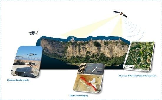
Graphical Abstract

1. Introduction

Geo-hydrological hazards, such as slope instabilities, often threaten human life, infrastructure and cultural heritage sites that represent unmovable assets relevant to human identity [1]. In the Marche region, there are many medieval villages built on the top of cliffs with local stone. The remarkable topographical location of these villages makes them vulnerable to slope instabilities that are difficult to study and monitor because of the inaccessibility of the steep cliffs. Nowadays, the growing technological development in the field of digital and remote sensing surveys is playing a key role in the study of such natural hazards. The application of digital surveys has become very important in the acquisition of geological and structural information directly on the field and in the immediate development of geodatabases [2,3,4,5,6]. Satellite and remote sensing techniques often represent the only methods for exploring and monitoring inaccessible areas and/or steep slopes [7]. In particular, the use of unmanned aerial vehicles (UAVs) and advanced differential SAR interferometry (A-DInSAR) has been exploited by many authors in the last decade to study ground deformation in cultural heritage sites [8,9]. A-DInSAR, which can be ground- or satellite based, makes it possible to monitor ground movements with millimeters of accuracy [10]. Diversely, UAVs are often used to improve the interpretation of geological and geomorphological features, especially in inaccessible areas [11,12,13,14].
This study was developed to address the following research question:
How can we identify potential slope instabilities in cultural heritage sites that are characterized by inaccessible areas and/or are not completely visible from the observation point?
Therefore, we aimed to present a fast and low-cost operational methodology based on the integration of field digital surveys, A-DInSAR and UAV analyses to obtain basic information for the study of geo-hydrological hazards in cultural heritage sites. Data gathered via the abovementioned survey techniques were used for GIS analyses, the creation of UAV-based 3D models, definitions of the structural setting and A-DInSAR-based velocity mapping. The methodology was developed and tested through two case studies, namely Montefalcone Appennino and Monte San Martino, located in the Marche Region of Italy (Figure 1). In particular, the two medieval towns are located between the Sibillini Mountains Massif (Central Apennines) and the Adriatic Sea, and both of them are characterized by a gently dipping morphology on their northeastern side and by very steep cliffs in the southwest (see Section 4.2 for more details).
This research shows how, by combining the abovementioned technologies and methodologies, it is possible to obtain a fast identification of the potential instabilities characterizing historical towns, while also pursuing economic advantages. Overall, the methodology can be replicated by other users to support assessments of the geo-hydrological hazards at cultural sites with similar characteristics to the ones presented in this research.

2. Geological Setting

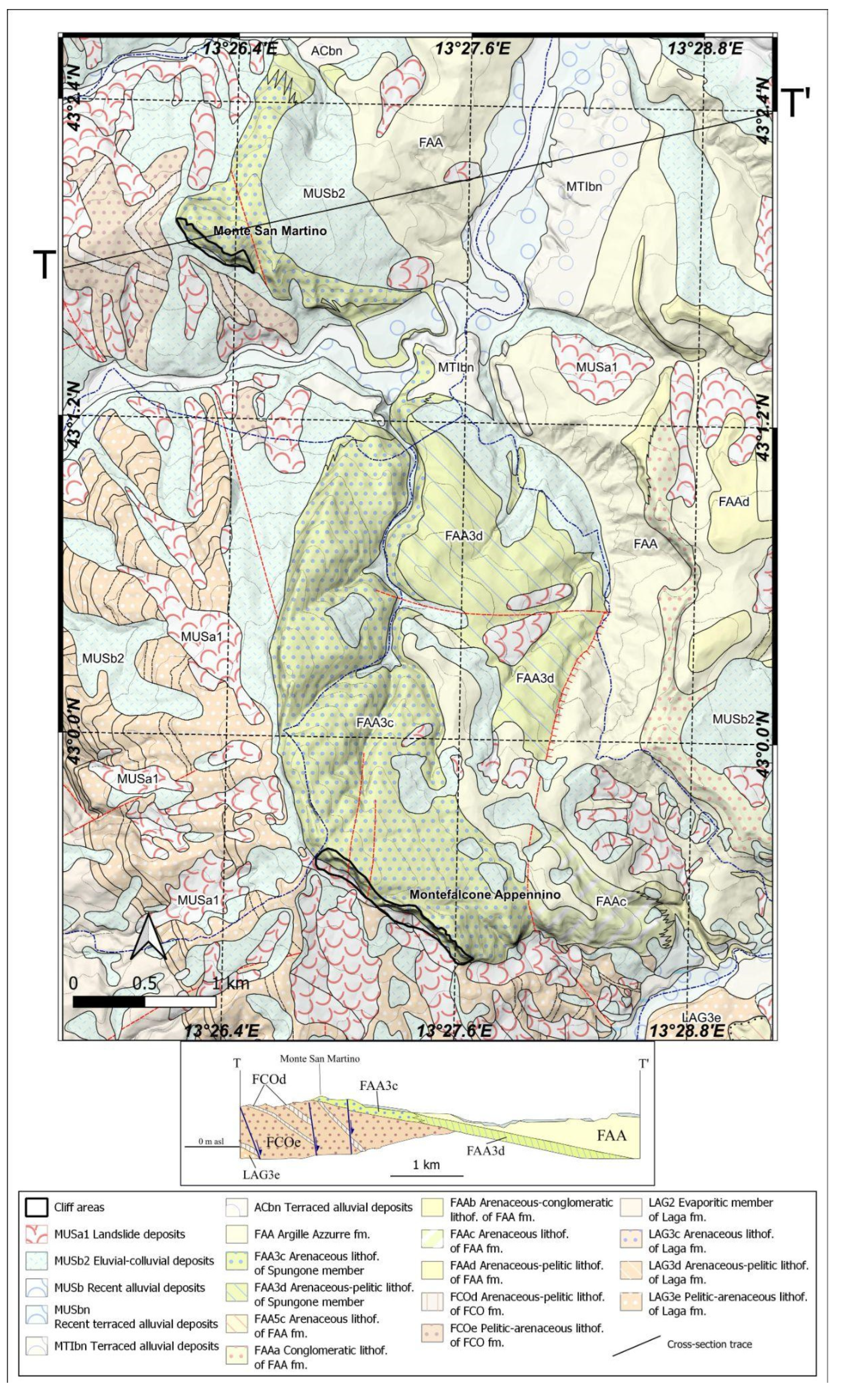
The case studies are located in a sedimentary basin characterized by early Pliocene sandstones and conglomerates, alternating with pelitic arenaceous levels (Argille Azzurre Formation, FAA). In particular, the two villages are built on top of the arenaceous-–conglomeratic sedimentary body of the FAA’s Spungone member (FAA3c and FAA3d lithofacies in Figure 2) that reaches its maximum thickness (about 200 m) right in the study area [15]. This unit represents coastal channelized and foreshore to shoreface sediments at the base of the Pliocene transgressive–regressive sequence overlying, with wide unconformity, to the Miocene Laga Formation (LAG Fm) or lower Pliocene FAA units [15]. Sediment facies change to offshore deposits from the west-southwest–east-northeast direction (Figure 2), which was the direction of sediment delivery. This setting outlines large-scale, slightly inclined depositional palaeosurfaces dipping according to the current strata’s dipping direction (east-northeast).
In the areas of Montefalcone Appennino, the FAA formation is deposited on top of the Miocene (Messinian) Laga Formation, a turbidite deposit characterized by arenaceous-pelitic and pelitic-arenaceous levels (Figure 2). In the case of Monte San Martino, due to the absence of the Laga Fm, the FAA is deposited on top of arenaceous-pelitic Messinian Argille a Colombacci Formation (FCO) (Figure 2).

3. Methods

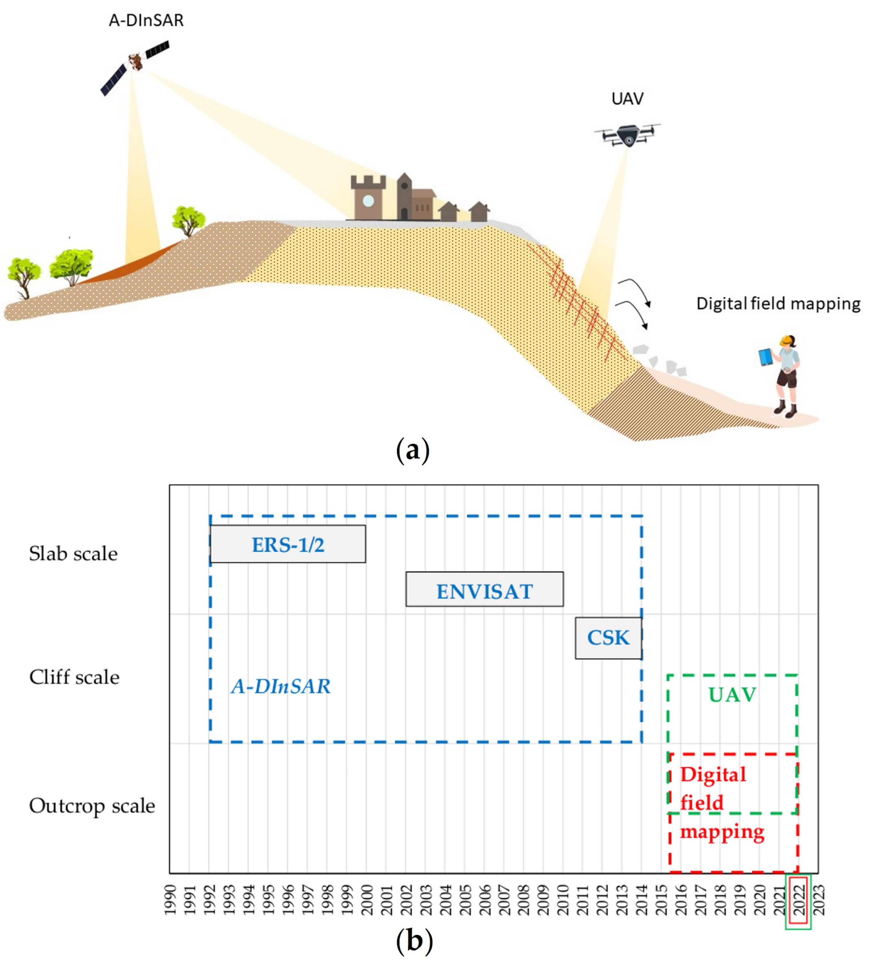
The aim of this work was to propose a low-cost and expeditious approach for the study of potential landslide phenomena affecting cultural heritage villages, based on the integrated use of digital surveying, A-DInSAR and UAV analyses. A schematic of the conceptual model of the data collection approach proposed in this research is shown in Figure 3a, highlighting the use of digital surveys for a more immediate collection of geological information in the field, A-DInSAR for the study of potential ground deformation and UAVs to explore inaccessible areas, such as the steep slopes on which historical cities were often built. In particular, the monitoring data of the trend in historical deformations during the period from 1992 to 2014 were analyzed using the A-DInSAR data, whereas the UAV and digital field mapping were performed in October 2022 to detect recent potential instabilities (Figure 3b). From the technical and economic points of view, the exploited techniques are convenient at specific scale, but their integration allows us to work from the outcrop to the slab scale to achieve full detection of the potential instabilities (Figure 3b). The collected information was organized, analyzed and integrated through GIS analyses, including raster elaborations of a digital elevation model (DEM) for geomorphological studies.
As presented here, this working system was designed to provide a fairly immediate answer to the need to know about problems of instability, but it is also designed as an open system that can be augmented with other information that may be available. Anyway, as shown in Figure 3, these can have spatiotemporal implications. Among these, recent or ancient historical information, if present, can be useful pillars for understanding and locating the evolutionary trends over time leading to the current hazards. Among the techniques used in this work, the GIS system was the basic tool that supported this integration operation thanks to (i) its ability to allow a strong interconnection between the historical data and spatial data and to manage georeferenced databases composed of information collected from historical and current sources, (ii) its versatility in displaying such data cartographically with more advanced graphic techniques and (iii) the possibility of carrying out statistical and spatial analyses of such data and their spatial coordinates.

3.1. Digital Field Survey

A high-performance tablet PCs (Microsoft Surface Pro 7) equipped with the Windows 10 operating system and an input pen (stylus) were exploited for this research. Microsoft’s tablet PCs are fully fitted with technical characteristics that are adequate for the management of maps, images and data used and/or collected on the ground (CPU Intel® Core™ i5-1135G4; RAM 8 GB; 128 GB disk; screen size 12.3″). The positioning was carried out with Garmin Glo receivers (GPS e GLONASS; update rate: 10 Hz; WAAS/EGNOS correction; accuracy: 3 m; battery life: 13 h) linked to the tablet via the Bluetooth data transmission standard. For the acquisition of photographs, both built-in and reflex cameras were used.
QGIS (version 3.22) [17], which is open-source software, was the cross-platform GIS software utilized, with the support of some plugins, such as BeePen [18] to write notes and draw geomorphological elements with the stylus directly on the base maps, similar to the pen-on-paper system [19]. Although simplified apps such as Qfield for QGIS [20] and Input [21] are now available for QGIS, we decided to use the conventional QGIS platform to avoid importing and exporting projects [22] and, more importantly, to be able to customize the QGIS toolbar, making it more suitable for fieldwork.
To make everything easier and more immediate during the field survey, a new interface with data acquisition modules was used for rapid data/information storage [23].
Other notes, sketches and sections were acquired using the Windows Journal software (version 10.0.173) [24], a free application that can be used as a real “field notebook”.
The integrated use of a tablet PC, Garmin Glo receivers, a built-in camera and Windows Journal played a key role during the fieldwork, with all geological information automatically included in the GIS database. The database was implemented in the Geopackage format, an open, platform-independent, native storage format, using an SQLite database as a container and the “Geopackage Encoding Standard” defining the schema for Geopackage [25].
In particular, through the digital field survey, we stored geological information in the geodatabase, such as the bedding attitude, geological limits, sketches of the geological sections, and photographs of the outcrops and installed mitigation measures.

3.2. DEM Analysis

The available DEM TINITALY 1.1 with a 10 m spatial resolution [26,27] was used for the quantitative geomorphological analysis, with the creation of some derived variables that are conditioning factors in a slope’s evolution. Specifically, the following surface geomorphic parameters were extracted: aspect, slope and profile curvature [28,29,30]. A SAGA-GIS [31] “Slope, Aspect, Curvature” module available in QGIS (SAGA version 7.8 of QGIS version 3.28) was applied.
Curvature is a complex derivative of the terrain, and its values depend upon the line or plane along which such calculations are made. The basic principle of calculating curvature is to pass a moving window over the elevation’s surface and fit the elevation’s values to a six-term polynomial function, the coefficients of which yield the curvature of the central cell of the moving window. Up to nine main types of curvature can be calculated [32], but the profile curvature was considered to be the most useful for the purposes of this study. The profile curvature was parallel to the direction of the maximum slope. In this study, for specific cells, a positive value indicated that the surface was upwardly convex, while negative values indicated that the surface was upwardly concave. A value of zero indicated that the surface was planar. The profile curvature is a geomorphometric variable interpreted in the literature as an indicator of acceleration or deceleration downslope from the gravity-driven flows [33,34] and it is believed to have an influence on the rate of denudation or accumulation along the slope’s profile [33,34], with the exception of curvature with zero values, which means equilibrium. In this case, it also acts as support for understanding the geomorphologic characterization of the slope and its evolutionary stage in the specific study environment.

3.3. UAV

Unmanned aerial vehicle (UAV) surveys were undertaken to gather information about the steep and inaccessible slopes characterizing the two medieval towns. This was performed using a DJI Mavic 2 Pro (SZ DJI Technology Co., Ltd, Shenzhen, China). The characteristics of the drone camera were a 20-megapixel resolution and a 28 mm focal length with f/2.8 to f/11 aperture and a maximum image size of 5472 × 3648 px. The drone was manually piloted, and photographs were acquired from an average distance of 50–70 m from the outcrops in order to extract high-resolution 3D models. The photographs’ side lap and overlap were kept to ~70–80%. Details about the UAV photogrammetric surveys are listed in Table 1.
An RTK-GNSS survey was undertaken to support the photogrammetric surveys and acquire the position of the ground control points (GCPs) to be used as reference points during the creation of the photogrammetric 3D model. A Trimble RTK-DGPS R8 with a stop-and-go technique, and a horizontal and vertical accuracy of ~10 mm and 15 mm, respectively, was used for this purpose. The GCPs were square yellow and black targets measuring 50 × 50 cm, distributed both on the top and bottom of the cliffs. The horizontal and vertical estimated error during the RTK-GNSS survey was ~3 cm and 3.5 cm, respectively. In total, 10 GCPs were measured (5 for each case study).
UAV photographs were processed using the Structure from Motion (SfM) software from Agisoft Metashape (version 1.5.2) [35], through which we created the georeferenced 3D point cloud models of the four investigated slopes. The management of the point cloud data and the definition of the characteristics of the rock masses, such as the geometry of the cliffs and the orientation of the discontinuity sets, were carried out using the free software CloudCompare (version 2.12) [36].

3.4. A-DInSAR

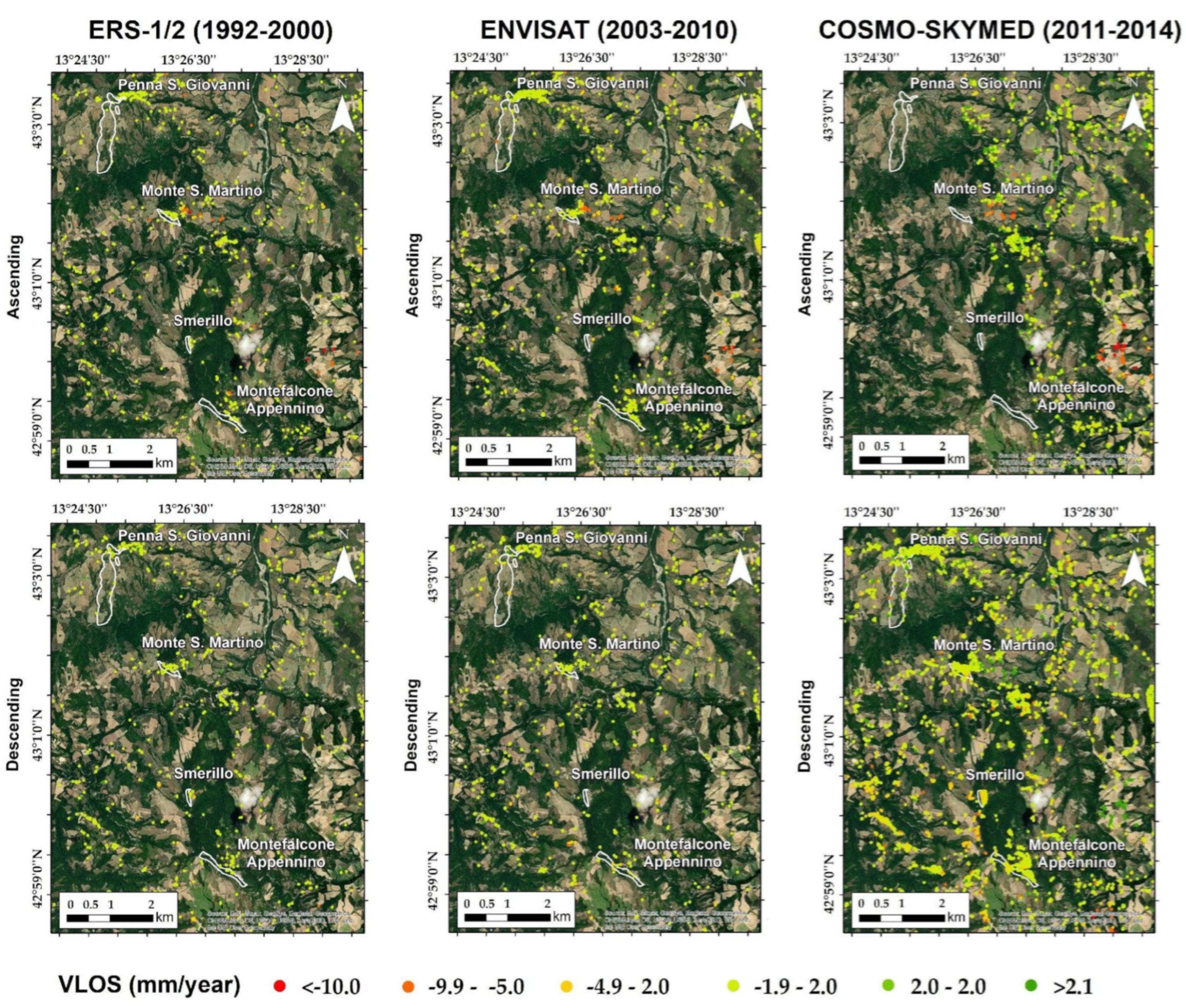
The A-DInSAR technique was exploited for back-monitoring the movements over the selected study areas. In particular, we used data acquired by the ERS1/2, ENVISAT and COSMO-SkyMed satellites, and data provided by the Italian Ministry for the Environment, Territory and Sea by means of the national geoportal (geoportale nazionale—GN) [37]. The ERS1/2, ENVISAT and COSMO-SkyMed SAR images covered the periods 1992–2000, 2003–2010 and 2011–2014, respectively (Figure 4). The SAR images were acquired in ascending and descending order of geometry by sensors in C-band (a wavelength of about 5.6 cm) for the ERS1/2, ENVISAT and X-band (wavelengths equal to 3.1 cm) for the COSMO-SkyMed data. The data were processed via the PSInSAR™ [10] and PSP-DifSAR [38] approaches, developed by the companies TRE-Altamira and e-GEOS, respectively. The results of the processing allowed us to obtain measuring points for which we could observe the average velocity along the line of sight (VLOS) of the satellite and the LOS time series of the displacements at the satellites’ acquisition dates, characterized by millimetric precision. Negative values represent movements away from the sensor mounted on the board of the satellite and the measuring point, whereas positive values indicate movements towards the sensor. Additional information about the A-DInSAR data is included in Table 2. The reliability of these A-DInSAR data has successfully been validated by other authors at other Italian test sites [39].

4. Results

The integration of different survey and analytical techniques played a key role in this research. The results of digital mapping and GIS elaborations were important to understand the geological and structural setting of the area and to develop a model of the evolution of the two case studies. Such information was then integrated with the UAV and A-DInSAR data to study the steep cliffs (UAV data) and detect potential slope failures at a larger scale (A-DInSAR data). Through the use of the proposed integrated methodology, based on the use of the freeware of the low-cost instruments and software, it was possible to gather important information about hazardous areas and their characteristics. The results of each technique are illustrated in the following sections.

4.1. Digital Field Mapping

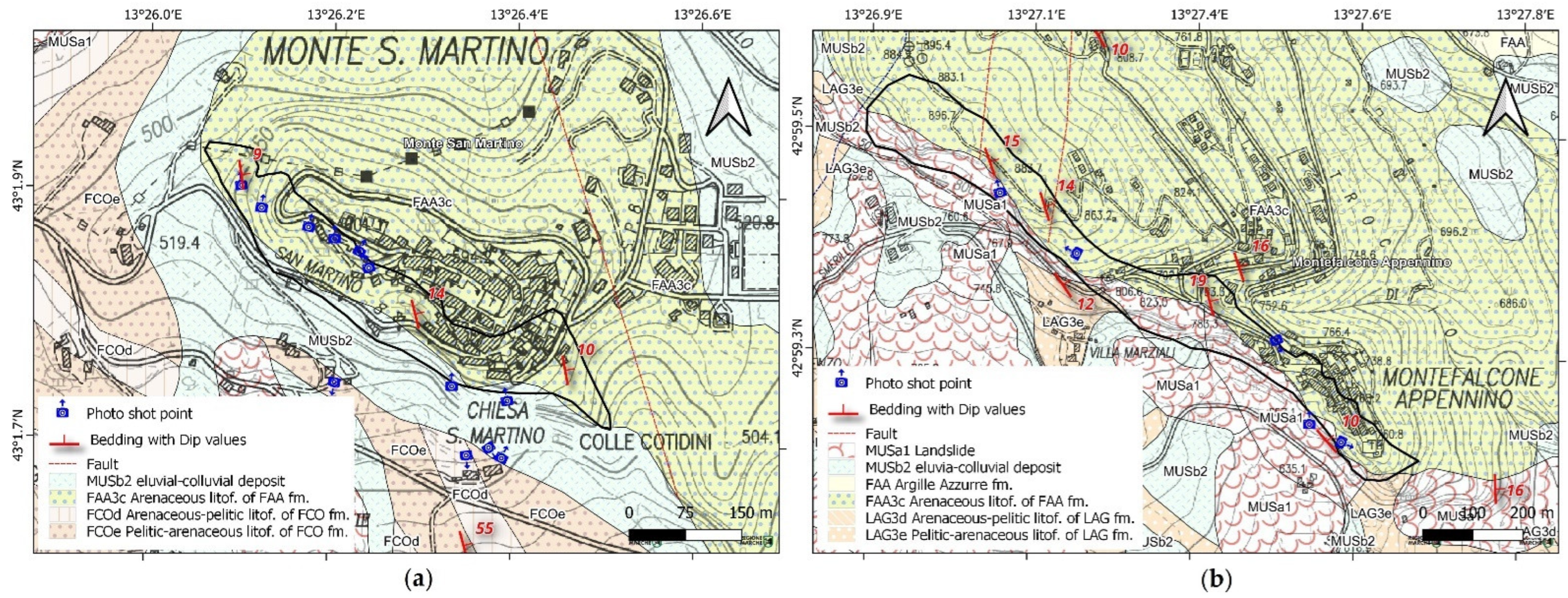
A digital field survey, undertaken following the procedure discussed in Section 3.1, was carried out to develop a geodatabase with geological and structural information and field photographs. During the survey, orthophotos and geological maps were used as base maps. Bedding attitudes and geological limits were added (or modified, when necessary) directly in the field. Photographs and their positions and shooting directions were stored in the geodatabase, and their locations are visible on the base maps. Figure 5 shows the results of the digital survey, with the geological map (after CARG Project [40]) highlighting the bedding attitudes and the shot points of the photographs.
The bedding attitudes were found to be similar between the two case studies, with a low-angle dip (from 10° to 20°) and the dip’s direction running from 70° to 80° (north-northwest orientation). The possibility of including photographs in the database also played an important role in the creation of a database containing the existing mitigation measures. Mapping of the mitigation measures (Figure 6) was important for the development of hazard maps and for planning multitemporal inspections and verifying their functionality over the years.

4.2. DEM-Based Geomorphologic Features

The study areas are located in a hilly landscape, with the maximum height of Monte San Martino and Montefalcone Appennino being 601 m and 768 m asl, respectively. By coupling this basic information with data on the slope and aspect, more details were obtained.
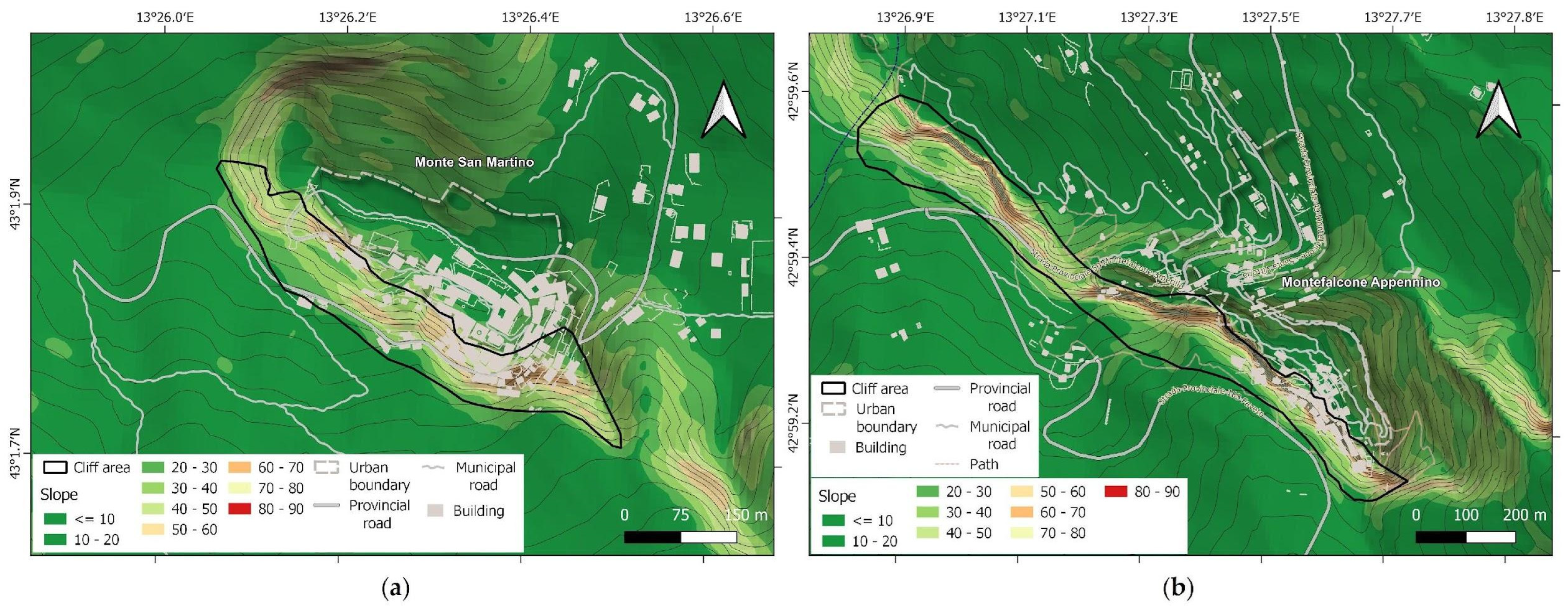
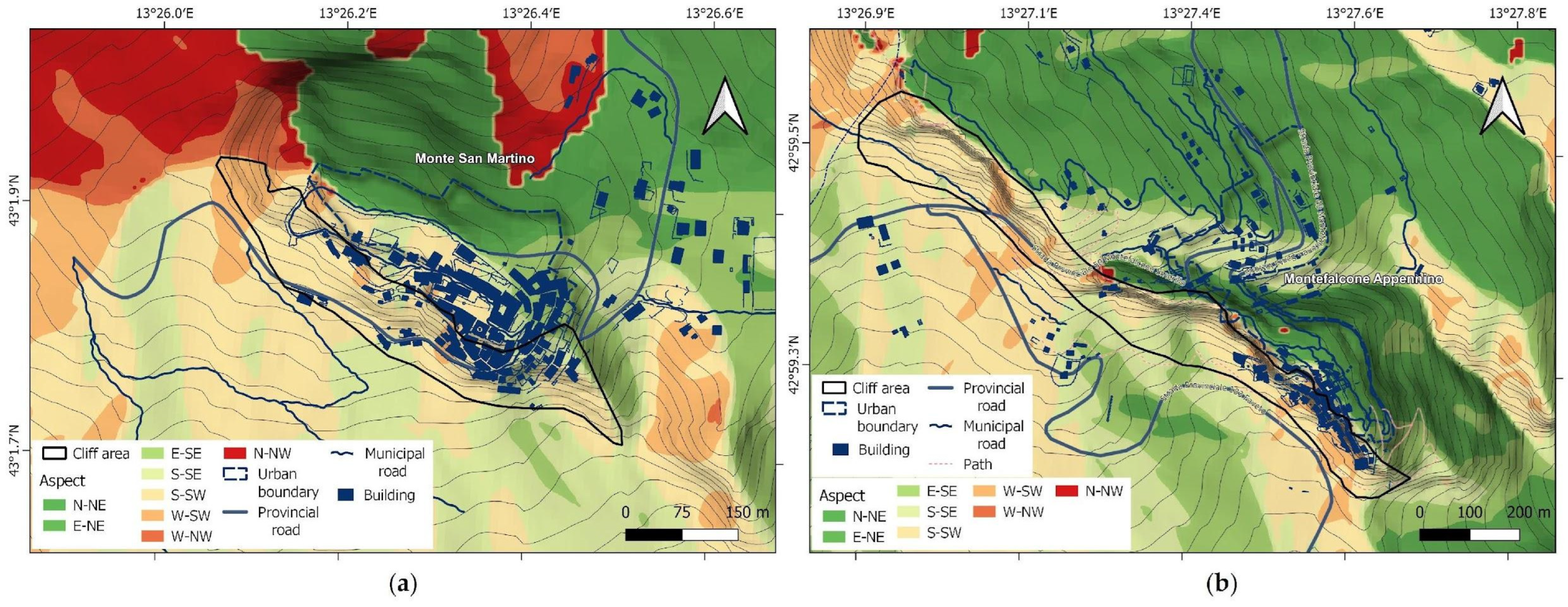
As far as the slopes studied are concerned, the cliff area has a maximum value of up to 76° (with an average steepness of 48°) at Montefalcone Appennino and a maximum value of up to 68° (with an average slope of 43°) at Monte San Martino. The gentler part of the reliefs, on which the ancient inhabited centers are located, dip in the opposite direction, towards the northeast, with an average slope of 28° and 23° at Montefalcone Appennino and Monte San Martino, respectively, in accordance with the structural geological setting of the entire territory (Figure 7). Both the cliffs bordering the towns dip towards the southwest (Figure 8).
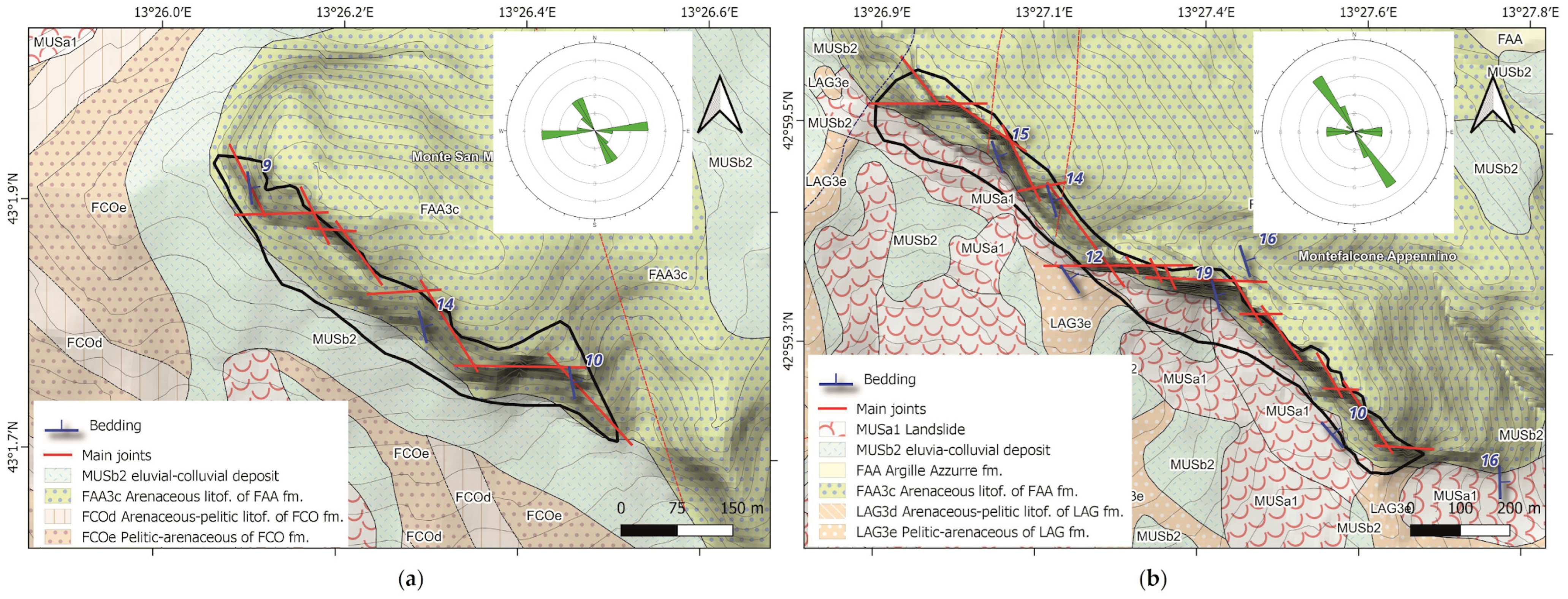
In addition, the trend of the cliffs’ surfaces was then considered in more detail for improving knowledge about the geometry and the structural settings. In particular, the main structural lineaments affecting the cliffs were identified. In both cases, the geometry of the cliff is controlled by discontinuity sets oriented northwest–southeast and east–west (Figure 9).
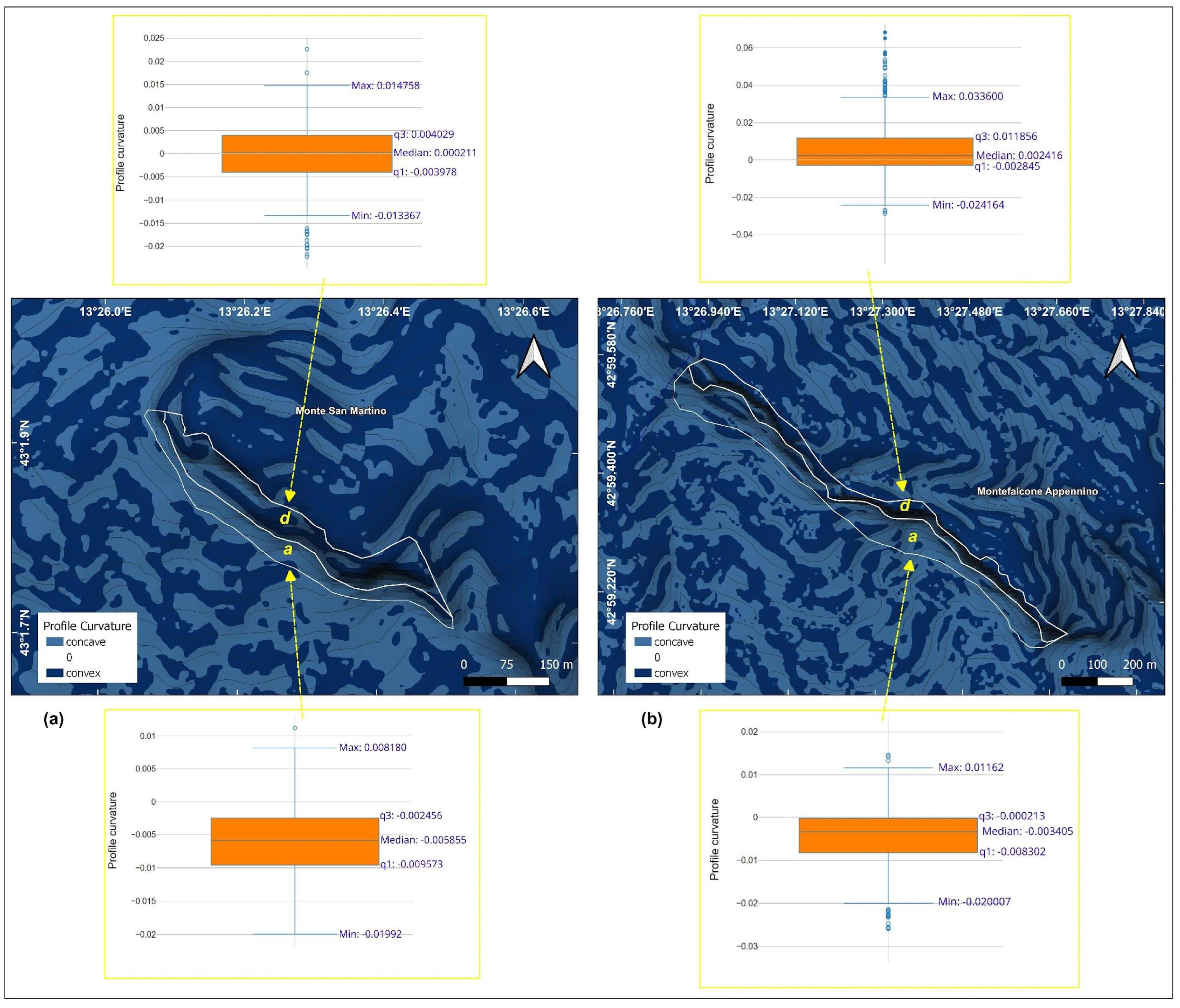
Finally, the hillslopes’ profile curvature was calculated in order to associate the local slope’s morphology to a specific model of evolution, according to the most accredited classifications in the world [41]. The resulting maps and the distribution of respective statistical values (Figure 10) show, in both cases, an overall convexity in the steepest portion of the cliffs, defined as detachment (d) areas, and a concavity in the toe of the slopes, described as accumulation (a) areas. These results, assessed together with the context of the geological setting, allowed us to associate the studied slopes with the model of evolution called “slope replacement” [42,43]. In accordance with this definition, the profiles of the bedrock on the detachment areas are convex diachronous surfaces that highlight the potential retreat of the slope. At the toe of the cliffs, typical regularized slopes are present, showing accumulation areas without signs of further removal of material and/or erosion processes of pluvial or fluvial origin. As a whole, these morphologies can be considered undeveloped, as the height of the overlying sub-vertical cliff is still much more extensive than the underlying replacement accumulations. Even the statistical distribution of each curvature value around the mean and median values still indicated an unbalanced profile, with median positive values in the detachment areas (convex slope) and negative in the accumulation areas (concave slopes).
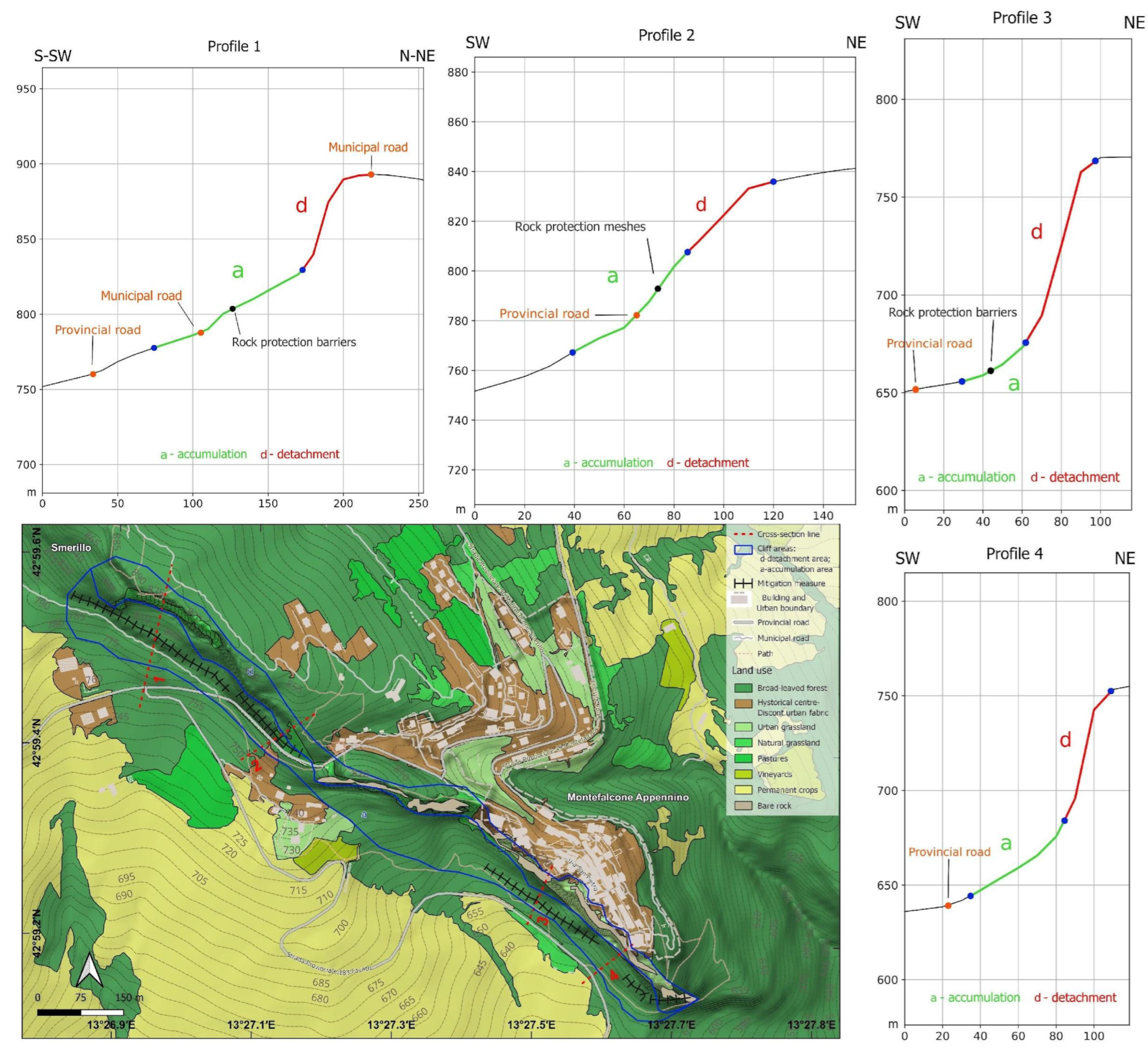
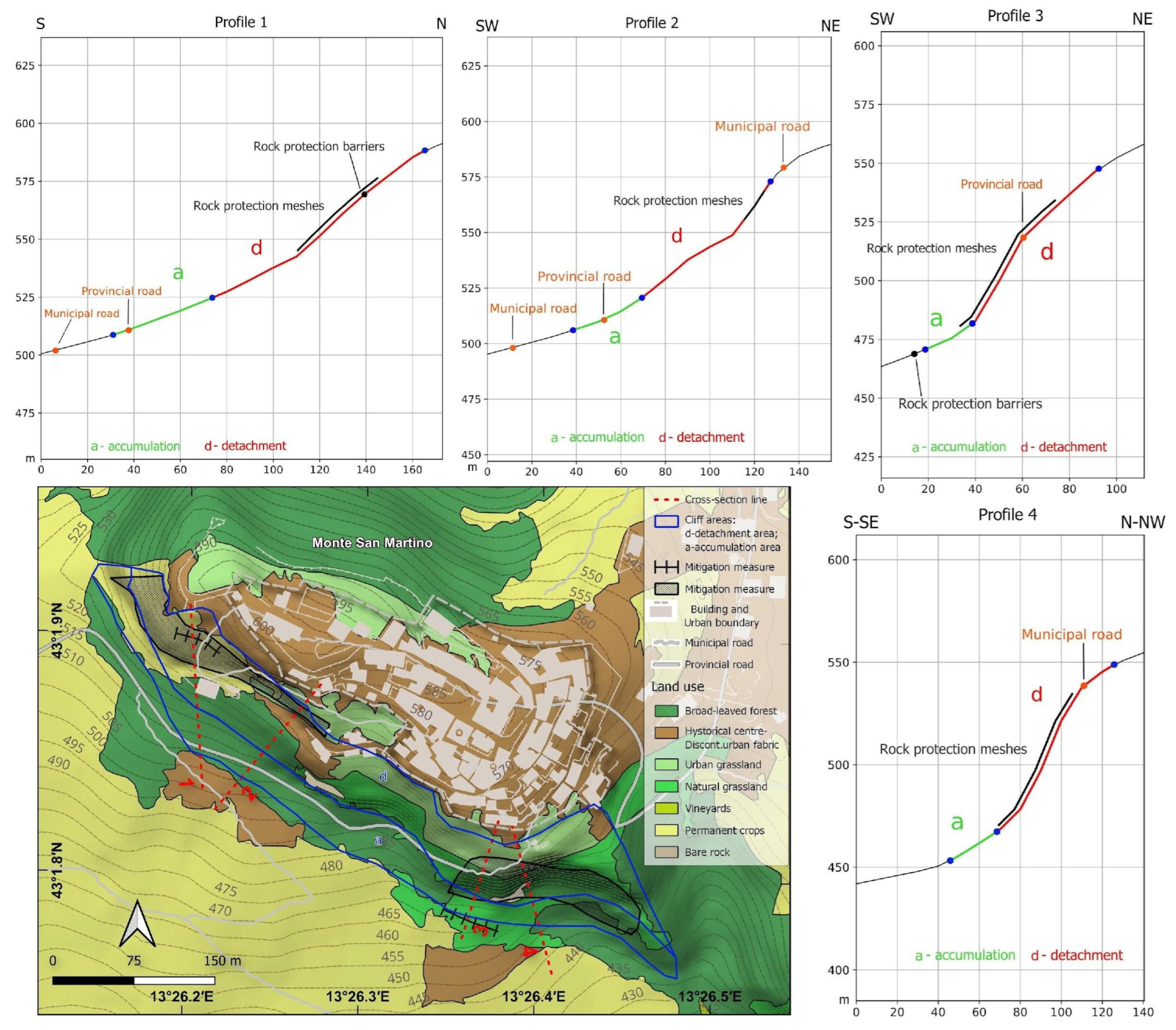
To further deepen all the abovementioned aspects, four profiles each were analyzed for Montefalcone Appennino (Figure 11) and Monte San Martino (Figure 12). From these, it was possible to underline the importance of anthropic pressure or anthropization. In fact, where there is the presence of the ancient and stable urban centers, degradation of the rock and retreating phenomena of the upper sectors of the slope (describable as “weathering-limited” slopes under strong structural control) has decreased. This is very evident in the analysis of the profiles at Monte Falcone Appennino. Profiles 1 and 2, drawn from a non-anthropized area, show a much greater state of evolution (i.e., advanced conditions of aggradation) than Profiles 3 and 4, which still highlight a very high steepness (demonstrating a lower rate of retrogression and evolution, Figure 11). In Monte San Martino, the same results were found for Profiles 3 and 4, which cross the steep cliff up to the town’s center. Profiles 1 and 2 were developed in areas close to the town’s center with widespread buildings and infrastructure, and they show greater evolution. This testifies that urbanization tends to decrease a slope’s retrogression. This is probably due to lower rate of water infiltration in the historical center [44,45]. It is also important to note that the evolution of urbanized areas has also been influenced in the last decades by the presence of mitigation measures installed on the cliffs, such as cortical strengthening and rock protection meshes. Finally, it is interesting to note that in other nearby and geologically similar cliff areas with no anthropic influence over the centuries, the evolution of the cliffs has been much greater, with major and more advanced evolution of the slope, in agreement with what was demonstrated by the analysis of the slope’s profile.

4.3. UAV Models and Structural Setting

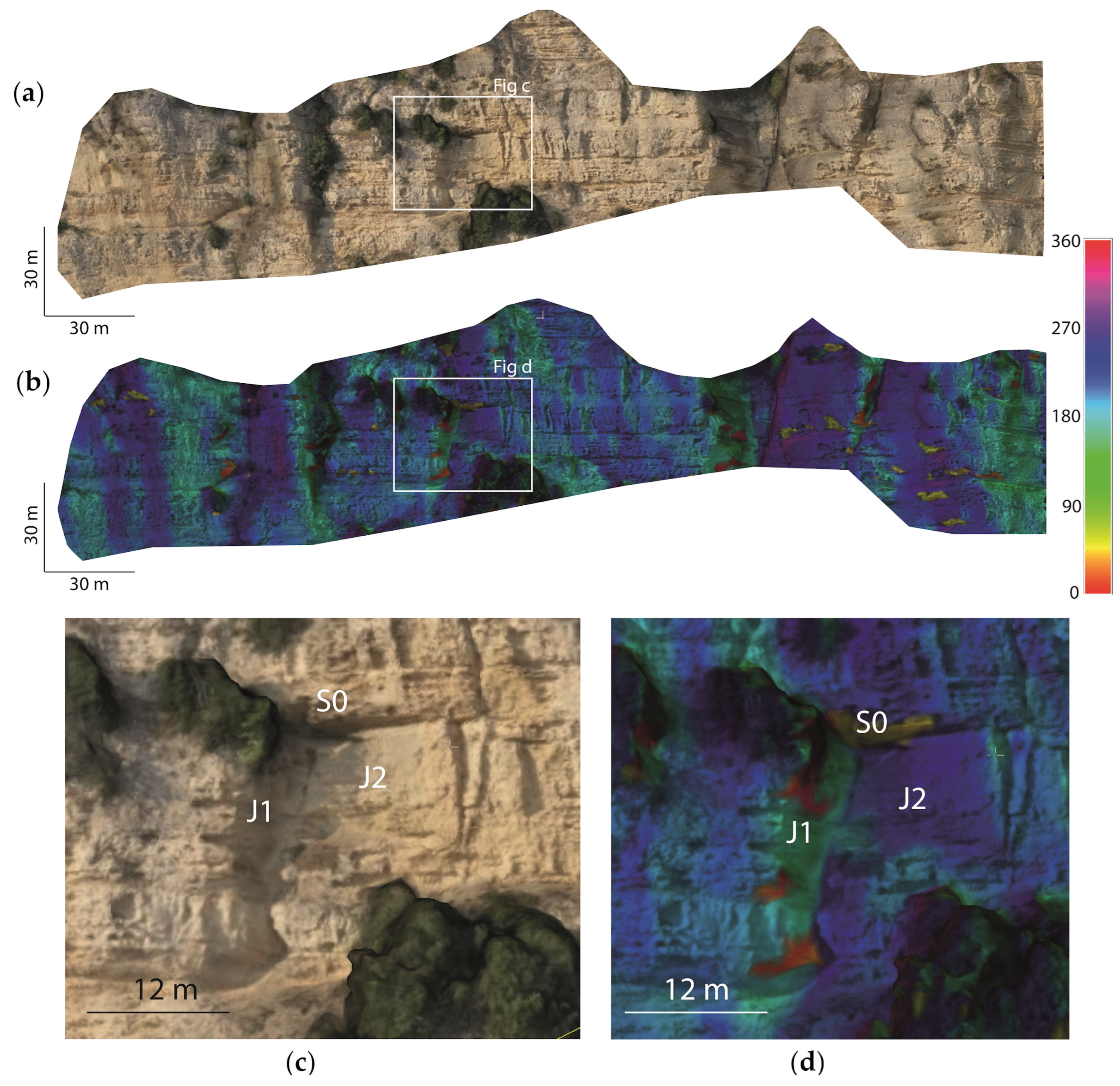
The main structural features visible in the UAV’s extracted 3D models were identified and measured using CloudCompare software. The results in terms of the main dip and the dip direction of the discontinuity sets are reported in Table 3. It can be seen that the general structural setting of the two areas is similar, with low-angle beddings dipping towards the east-northeast, two high-inclination joint sets orthogonal to the bedding and oriented approximately north–south and east–west and a third set oriented approximately northeast–southwest. Kinematically, considering the dip direction of the two cliffs (approximately southwest), the slopes are prone to both rockfall (especially due to the J2) and wedge failures along the intersection of J1 and J2. An example of the interpretation of the joint set and of their influence on the geometry and stability of the cliff is reported in Figure 13. In particular, Figure 13a shows the 3D model of the cliff in RGB colors, while in Figure 13b, the color bar represents the dip directions of the slope faces (and joints). From Figure 13b, it is possible to see how the two main joint sets, J1 (light blue) and J2 (dark blue), have influenced the slope’s geometry. Figure 13c,d shows a sector of the slope where the intersection of S0, J1 and J2 brought about the detachment of a large rock block (the sides of the block measured ~16 m × 12 m × 7 m, with an estimated volume of 1344 cubic meters).
Such results highlight how in the cliffs of both Montefalcone Appennino and Monte San Martino, the geometry is strongly controlled by J1 and J2, in agreement with what was showed by ana analysis of the lineaments (Figure 9).

4.4. A-DInSAR-Based Velocity and Displacement Time Series

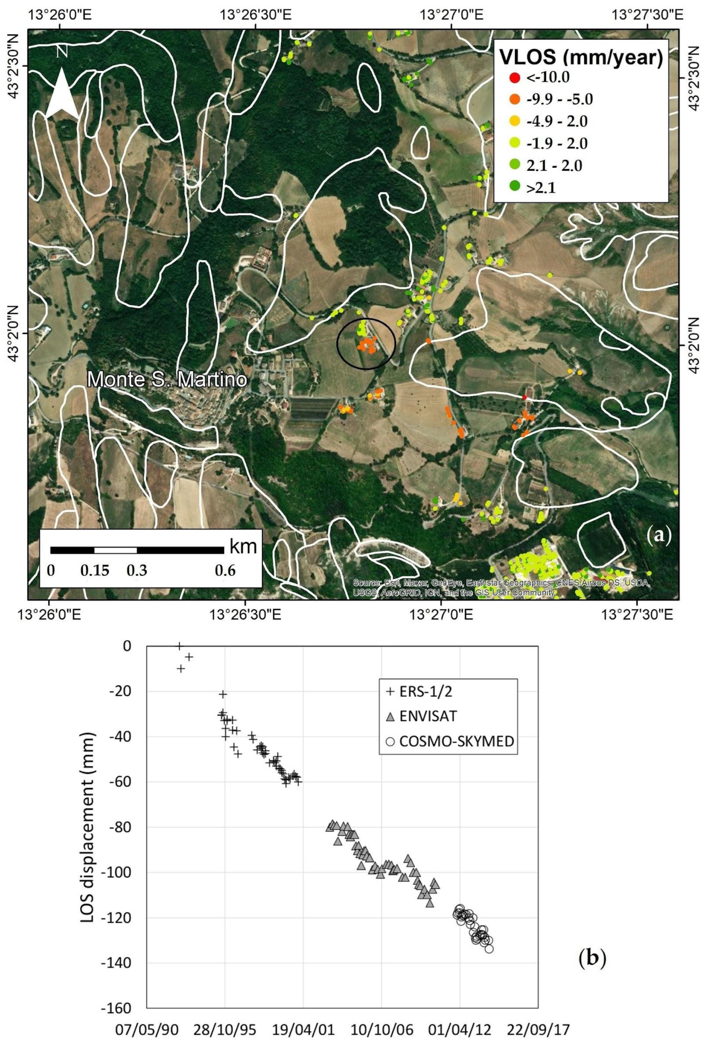
At Monte San Martino village, the A-DInSAR data were exploited to verify if the cliff was involved in retreating movements in the urbanized area. The use of the ERS, ENVISAT and COSMO-SkyMed data showed a steady displacement time series for the monitored periods with VLOS values of −0.35–0.7, −2.4–1.1 and −4.7–1, respectively. The COSMO-SkyMed ascending data were not available for the historical village of Monte San Martino. It is worth noting that in the northeastern area of the village, slow-moving landslides were previously mapped in the less steep rural zone. In this sector, the movements were also detected by the A-DInSAR data and, in particular, by using the ascending data and the ERS, ENVISAT and COSMO-SkyMed data. These displayed anomalous movements reaching average VLOS values of around −5 mm/year. The kinematic model of the target was investigated using statistical analysis [46] and a linear displacement time series trend was detected (Figure 14). The anomalous movements were detected in proximity to previously mapped landslides but outside their boundaries.
Additional investigations should be performed to verify if these active areas represent new landslides to be mapped or enlargement of the boundaries of the previously mapped slow-moving landslides.
Similar conclusions can be drawn for Montefalcone Appennino. The A-DInSAR data were investigated to detect slow retreat movements that could affect the historical village. The results of the analysis showed that no significant movements were evident. Indeed, the displacement time series were characterized by a steady trend and VLOS mainly in the range from −2 to 2 mm/year.
Overall, the A-DInSAR analysis presented here represents the first-ever baseline assessment of the surface movements affecting these four historical villages located in the Marche Region covering the period from 1992 up to 2014.

5. Discussion

Montefalcone Appennino and Monte San Martino are two historical sites in the Marche Region of Italy. They are located at the top of two steep cliffs, which, in the past, have been affected by rockfall events and issues of retrogression. Assessment of the geo-hazards of such historical sites represents an important task both for the safety of people living in the area and for preservation of the cultural heritage [47]. Montefalcone Appennino has been studied in the past by other authors with the goal of reconstructing its structural and geomorphological evolution [48,49,50]. Montefalcone Appennino and Monte San Martino are relevant spots for the landslide community involved in the safeguarding of cultural heritage and of the population at risk. In other similar morphological contexts, the San Leo village has been erected, located near Rimini (northern Italy). It was built in the medieval period on the top of a calcarenite and sandstone plateau [51]. A similar context is also observed at Civita di Bagnoregio (Italy), which is a typical medieval town, built on top of a volcanic cliff [52]. A comparison of our results with those of the cited studies confirmed that advanced monitoring approaches are necessary to preserve these fragile territories.
In this research, we have presented an integrated approach which allows the multitemporal analysis of these historical sites. Digital surveys were undertaken to gather data about the most relevant geological and geomorphological features of the accessible areas and to develop a database with all the useful territorial information, including the mitigation measures. In this study, the development of the geodatabase was achieved using freeware tools [6,53], so they decreased the costs associated with the study remarkably, and the data of the digital ground survey were integrated with data acquired by remote sensing and GIS techniques.
UAV analyses improved the understanding of the structural setting in steep, inaccessible areas. Three main discontinuity sets were found, affecting the geometry of the cliff and its stability. In particular, it highlighted how the interaction between the set J1 and J2 and the bedding planes tended to create kinetically unstable wedges (sometimes with large volumes) along the cliffs. The use of UAVs for determining the volumes of potential block has been presented by several authors in the past few years. Yakar et al. [54] and Francioni et al. [12] illustrated how the use of UAV can play a key role in the analysis of stochastic fractures and improved analyses of rockfalls. More recently, Graber and Santi [13] presented interesting research about the use of UAVs for monitoring natural slopes in Colorado (USA). Other interesting studies highlighting the use of UAVs in historical and cultural heritage sites in Turkey were presented by Karataş and Alptekin [54,55], and Sasi [56].
Unlike these investigations, in this study, we aimed to develop a methodology that is able to analyze the evolutionary trends of the slopes and the different failure mechanisms potentially affecting the study areas. Therefore, it was fundamental to merge the fracture and rockfall analyses with digital field data, interpretations of DEM derivatives and A-DInSAR data. Interpretations of the DEM derivatives were organically used to understand the geomorphological conditions of the slope under natural evolution and under the influence of anthropic interventions according to the model of evolution proposed by Penk [42] and Lehmann [43].
A-DInSAR, on the other hand, made it possible to analyze and monitor the areas in proximity to the cliffs and the potential presence of slow-moving phenomena in the gently dipping slopes on the northwest side of the towns. The A-DInSAR technique is a well-known approach used to detect and monitor slow-moving landslides [57,58,59]. However, rockfalls are characterized by rapid and very rapid velocities [60], decreasing the applicability of this technique to these phenomena. Indeed, one of the limits of this technique is the maximum displacement detectable, which corresponds to a quarter of the radar’s wavelength [61]. However, in some cases, the rockfalls can be preceded by small levels of sliding that separate these materials from the undisturbed deposits. Thus, some studies have used the A-DInSAR technique to assess the stability of the rock mass and slow ground displacements and accelerations, as precursory phenomena [62,63,64]. In this work, the A-DInSAR data were exploited to back-monitor the stability condition of rock slopes over large areas in order to detect critical localized areas that could need further in-depth investigation for the selected historical villages. The methodology may be applied to other regions facing similar challenges, such as the villages of San Leo or Civita di Bagnoregio. Remote sensing technologies could be applied to acquire data over large-scale inaccessible areas, whereas the digital field survey could be applied at the outcrop scale. The integration of data gathered from UAV, DEM analysis and A-DInSAR, together with the database of the installed mitigation measures, represents a fundamental tool for future risk mitigation plans for rocky cliffs.

6. Conclusions

The historical sites of Montefalcone Appenino and Monte San Martino have been used in this research to test a low-cost integrated approach for the analysis of historical towns potentially affected by landslides/rockfalls. The two areas present a similar structural setting, with low-angle bedding planes dipping east-northeast and three main joint sets. Steep rocky cliffs border the two towns, with similar southwest dip directions. Kinematically, the intersection of J1, J2 and S0 tends to detach blocks (sometimes with a high volume) from the cliff. The A-DInSAR analysis highlights that buildings in proximity to the cliff do not show evidence of movement. However, in the case of Monte San Martino, the same analysis displays the presence of a landslide failure along the northwest side of the town. This is probably related to the displacement of more recent eluvial-colluvial deposits in contact with the arenaceous bedrock.
The study demonstrated how the integration of the three techniques can be important to develop a complete and exhaustive analysis of the potential failures affecting historical towns. In addition, the spatial and temporal scalability of the obtainable data, as well as the methodological integrability, make the proposed operational approach widely applicable to other landscape contexts characterized by similar slope issues.
In particular:
  • Digital geological surveys permit the development of geodatabases directly in the field, including all the information about the geology and mitigation measures installed.
  • GIS outputs showcase useful morphometric and morphodynamic information to deepen the knowledge of the studied hills and to support the study with other survey techniques. Furthermore, the use of the profile curvature and the slope’s profile was important to understand the role of urbanization in the historical town built on top of the cliff face. In fact, urbanization decreases water infiltration in the slopes and, at the same time, the slope’s evolution.
  • The use of UAV is fundamental for defining the main discontinuity sets affecting the steep cliff and the volume of potentially failing blocks. This, in combination with the information about the installed mitigation measures, permits us to remarkably improve rockfall mitigation strategies.
  • A-DInSAR playes a key role in the identification of potential slow-moving landslides, which impossible to be detected with UAV and digital surveys.

Author Contributions

Conceptualization, M.F., R.B. and S.M.; methodology, M.F., R.B., M.D.D., G.F.P. and S.M.; validation, M.F., R.B., G.F.P. and S.M.; investigation, M.F., R.B., M.D.D., G.F.P., S.M. and L.M.; data curation, M.F., R.B., M.D.D., G.F.P. and S.M.; writing—original draft preparation, M.F., R.B. and S.M.; writing—review and editing, M.F., R.B., M.D.D., G.F.P. and S.M.; funding acquisition, M.F. All authors have read and agreed to the published version of the manuscript.

Funding

This research was funded by the Department of Pure and Applied Sciences of the University of Urbino, DispeaProg22.

Data Availability Statement

Data available on request due to privacy.

Conflicts of Interest

The authors declare no conflict of interest.

References

  1. Morelli, S.; Pazzi, V.; Tanteri, L.; Nocentini, M.; Lombardi, L.; Gigli, G.; Tofani, V.; Casagli, N. Characterization and Geotechnical Investigations of a Riverbank Failure in Florence, Italy, UNESCO World Heritage Site. J. Geotech. Geoenviron. Eng. 2020, 146, 05020009. [Google Scholar] [CrossRef]
  2. Gallerini, G.; De Donatis, M.; Baioni, D.; Bruciatelli, L. Landslide Field Mapping with Tablet Pc. A New Integrated Approach. In Proceedings of the 11th International Conference and Field Trip on Landslides, Norway, Landslides, Norway, 1–10 September 2005; Taylor & Francis: London, UK; Vol. Landslides and Avalanches, Proceedings, pp. 107–113. [Google Scholar]
  3. Baioni, D.; De Donatis, M.D.D.M.; Giuliano, G. Bruciatelli Lorenzo Il Mobile-Gis per La Geologia Ambientale: Il Rilevamento Digitale Applicato Alle Frane. Geol. Dell’ambiente 2007, 15, 21–26. [Google Scholar]
  4. Gallerini, G.; De Donatis, M. Rilevamento Digitale Delle Frane: Applicazione Della Scheda IFFI. Rend. Della Soc. Geol. Ital. 2007, 4, 49–53. [Google Scholar]
  5. Evans, H.; Pennington, C.; Jordan, C.; Foster, C. Mapping a Nation’s Landslides: A Novel Multi-Stage Methodology. In Landslide Science and Practice: Volume 1: Landslide Inventory and Susceptibility and Hazard Zoning; Margottini, C., Canuti, P., Sassa, K., Eds.; Springer: Berlin/Heidelberg, Germany, 2013; pp. 21–27. ISBN 978-3-642-31325-7. [Google Scholar]
  6. De Donatis, M.; Pappafico, G.F.; Romeo, R.W. A Field Data Acquisition Method and Tools for Hazard Evaluation of Earthquake-Induced Landslides with Open Source Mobile GIS. ISPRS Int. J. Geo-Inf. 2019, 8, 91. [Google Scholar] [CrossRef]
  7. Casagli, N.; Frodella, W.; Morelli, S.; Tofani, V.; Ciampalini, A.; Intrieri, E.; Raspini, F.; Rossi, G.; Tanteri, L.; Lu, P. Spaceborne, UAV and Ground-Based Remote Sensing Techniques for Landslide Mapping, Monitoring and Early Warning. Geoenvironmen. Disasters 2017, 4, 9. [Google Scholar] [CrossRef]
  8. Tapete, D.; Cigna, F. COSMO-SkyMed SAR for Detection and Monitoring of Archaeological and Cultural Heritage Sites. Remote Sens. 2019, 11, 1326. [Google Scholar] [CrossRef]
  9. Mateos, R.M.; Ezquerro, P.; Azañón, J.M.; Gelabert, B.; Herrera, G.; Fernández-Merodo, J.A.; Spizzichino, D.; Sarro, R.; García-Moreno, I.; Béjar-Pizarro, M. Coastal Lateral Spreading in the World Heritage Site of the Tramuntana Range (Majorca, Spain). The Use of PSInSAR Monitoring to Identify Vulnerability. Landslides 2018, 15, 797–809. [Google Scholar] [CrossRef]
  10. Ferretti, A.; Prati, C.; Rocca, F. Permanent Scatterers in SAR Interferometry. IEEE Trans. Geosci. Remote Sens. 2001, 39, 8–20. [Google Scholar] [CrossRef]
  11. Sarro, R.; Riquelme, A.; García-Davalillo, J.C.; Mateos, R.M.; Tomás, R.; Pastor, J.L.; Cano, M.; Herrera, G. Rockfall Simulation Based on UAV Photogrammetry Data Obtained during an Emergency Declaration: Application at a Cultural Heritage Site. Remote Sens. 2018, 10, 1923. [Google Scholar] [CrossRef]
  12. Francioni, M.; Antonaci, F.; Sciarra, N.; Robiati, C.; Coggan, J.; Stead, D.; Calamita, F. Application of Unmanned Aerial Vehicle Data and Discrete Fracture Network Models for Improved Rockfall Simulations. Remote Sens. 2020, 12, 2053. [Google Scholar] [CrossRef]
  13. Graber, A.; Santi, P. UAV-Photogrammetry Rockfall Monitoring of Natural Slopes in Glenwood Canyon, CO, USA: Background Activity and Post-Wildfire Impacts. Landslides 2023, 20, 229–248. [Google Scholar] [CrossRef]
  14. Mammoliti, E.; Pepi, A.; Fronzi, D.; Morelli, S.; Volatili, T.; Tazioli, A.; Francioni, M. 3D Discrete Fracture Network Modelling from UAV Imagery Coupled with Tracer Tests to Assess Fracture Conductivity in an Unstable Rock Slope: Implications for Rockfall Phenomena. Remote Sens. 2023, 15, 1222. [Google Scholar] [CrossRef]
  15. Micarelli, A.; Cantalamessa, G.; Didaskalou, P.; Potetti, M.; Pambianchi, G.; Le Pera, E.; Critelli, S.; Pennesi, T.; Mazzoli, S. Note Illustrative Della Carta Geologica D’italia Alla Scala 1:50.000. Foglio 314 Montegiorgio; Note illustrative della Carta Geologica d’Italia in scala 1:50.000; APAT-Servizio Geologico d’Italia: Rome, Italy, 2006. [Google Scholar]
  16. Micarelli, A.; Cantalamessa, G.; Di Celma, C.; Piccini, M.; Sabatinelli, M.; Mazzoli, S. Geological Sheet 314 “Montegiorgio” of the Geologic Map of Italy at the Scale of 1:50.000. 2006. Available online: https://www.isprambiente.gov.it/Media/carg/314_MONTEGIORGIO/Foglio.html (accessed on 27 November 2023).
  17. QGIS software (version 3.22) by Development Team QGIS Geographic Information System QGIS. Available online: https://www.qgis.org/it/site/ (accessed on 28 September 2022).
  18. Alberti, M. BeePen, Python Plugin for QGIS Software 2019. Available online: https://github.com/mauroalberti/beePen (accessed on 14 August 2022).
  19. De Donatis, M.; Alberti, M.; Cesarini, C.; Menichetti, M.; Susini, S. Open Source GIS for Geological Field Mapping: Research and Teaching Experience. PeerJ 2016, 4, e2258v3. [Google Scholar] [CrossRef]
  20. OPENGIS.Ch. Available online: https://www.opengis.ch/ (accessed on 7 October 2022).
  21. Mergin Maps: Raccogliere, Archiviare e Analizzare Facilmente i Dati Geografici. Available online: https://it.merginmaps.com/ (accessed on 7 September 2023).
  22. Campbell, E.; Duncan, I.; Hibbitts, H. Analysis of Errors Occurring in the Transfer of Geologic Point Data from Field Maps to Digital Data Sets. In Proceedings of the Workshop Proceedings, Baton Rouge, LA, USA, 24–27 April 2005; USGS: Baton Rouge, LA, USA; Vol. U.S. Geological Survey Open-File Report 2005-1428, pp. 61–65. [Google Scholar]
  23. De Donatis, M.; Pappafico, G.F.; Bonì, R.; Francioni, M.; Marino, L.; Morelli, S.; Zatserkovny, V.I. Landslide Field Mapping: IFFI-Restart Forms for Data Acquisition and Management for the Classification of Landslides in the Municipalities Affected by the 2016 Central Italy Earthquake. Preprints 2022, 2022110461. [Google Scholar] [CrossRef]
  24. Microsoft Corporation Windows Journal Software for Windows, 7. 2021. Available online: https://www.microsoft.com/en-us/download/details.aspx?id=53003 (accessed on 27 November 2023).
  25. GeoPackage Encoding Standard. Open Geospatial Consortium. Available online: https://www.geopackage.org/ (accessed on 27 November 2023).
  26. Tarquini, S.; Isola, I.; Favalli, M.; Mazzarini, F.; Bisson, M.; Pareschi, M.T.; Boschi, E. TINITALY/01: A New Triangular Irregular Network of Italy. Annals of Geophysics. 2007. Available online: http://hdl.handle.net/2122/3673 (accessed on 27 November 2023).
  27. Tarquini, S.; Isola, I.; Favalli, M.; Battistini, A.; Dotta, G. TINITALY, a Digital Elevation Model of Italy with a 10 Meters Cell Size (Version 1.1). Istituto Nazionale di Geofisica e Vulcanologia (INGV) 2023. [Google Scholar] [CrossRef]
  28. Li, Z.; Zhu, Q.; Gold, C. Digital Terrain Modeling: Principles and Methodology; CRC Press: New York, NY, USA, 2005; ISBN 978-0-415-32462-5. [Google Scholar]
  29. Morelli, S.; Pazzi, V.; Frodella, W.; Fanti, R. Kinematic Reconstruction of a Deep-Seated Gravitational Slope Deformation by Geomorphic Analyses. Geosciences 2018, 8, 26. [Google Scholar] [CrossRef]
  30. Radło-Kulisiewicz, M. Review of DTM Derivatives Most Used in Digital Soil Mapping. Geomat. Landmanag. Landsc. 2021, 87–99. [Google Scholar] [CrossRef]
  31. Conrad, O.; Bechtel, B.; Bock, M.; Dietrich, H.; Fischer, E.; Gerlitz, L.; Wehberg, J.; Wichmann, V.; Böhner, J. System for Automated Geoscientific Analyses (SAGA) v. 2.1.4. Geosci. Model Dev. 2015, 8, 1991–2007. [Google Scholar] [CrossRef]
  32. Blaga, L. Aspects Regarding the Significance of the Curvature Types and Values in the Studies of Geomorphometry Assisted by GIS. Anal. Univ. Oradea Ser. Geogr. 2012, 2012, 327–337. [Google Scholar]
  33. Minár, J.; Jenčo, M.; Evans, I.S.; Minár, J., Jr.; Kadlec, M.; Krcho, J.; Pacina, J.; Burian, L.; Benová, A. Third-Order Geomorphometric Variables (Derivatives): Definition, Computation and Utilization of Changes of Curvatures. Int. J. Geogr. Inf. Sci. 2013, 27, 1381–1402. [Google Scholar] [CrossRef]
  34. Florinsky, I.V. An Illustrated Introduction to General Geomorphometry. Prog. Phys. Geogr. Earth Environ. 2017, 41, 723–752. [Google Scholar] [CrossRef]
  35. Agisoft Metashape, version 1. 6.4; Agisoft LLC: St. Petersburg, Russia, 2020. [Google Scholar]
  36. CloudCompare-Open Source Project 2022, version 2.12.4. Available online: https://www.danielgm.net/cc/ (accessed on 6 September 2023).
  37. Di Martire, D.; Paci, M.; Confuorto, P.; Costabile, S.; Guastaferro, F.; Verta, A.; Calcaterra, D. A Nation-Wide System for Landslide Mapping and Risk Management in Italy: The Second Not-Ordinary Plan of Environmental Remote Sensing. Int. J. Appl. Earth Obs. Geoinf. 2017, 63, 143–157. [Google Scholar] [CrossRef]
  38. Costantini, M.; Falco, S.; Malvarosa, F.; Minati, F. A New Method for Identification and Analysis of Persistent Scatterers in Series of Sar Images. In Proceedings of the IGARSS 2008—2008 IEEE International Geoscience and Remote Sensing Symposium, Boston, MA, USA, 7-11 July 2008; Volume 2, pp. 449–452. [Google Scholar]
  39. Tapete, D.; Cigna, F. Satellite-Based Preventive Diagnosis: Use of Persistent Scatterer Interferometry on Cultural Heritage Sites in Italy. In Proceedings of the Remote Sensing and Photogrammetry Society Conference 2012, London, UK, 12–14 September 2012; University of Greenwich: London, UK; pp. 1–4. [Google Scholar]
  40. CARG Project-Geologic and Geothematic Cartography. Available online: https://www.isprambiente.gov.it/en/projects/soil-and-territory/carg-project-geologic-and-geothematic-cartography-1 (accessed on 12 October 2022).
  41. Bartolini, C.; Peccerillo, A. I Fattori Geologici Delle Forme del Rilievo; Il Sistema Terra; Pitagora Editrice: Bologna, Italy, 2002; ISBN 88-371-1203-3. [Google Scholar]
  42. Penck, W. Die Morphologische Analyse: Ein Kapitel Der Physikalischen Geologie; J. Engelhorns Nachf.: Stuttgart, Germany, 1924. [Google Scholar]
  43. Lehmann, O. Morphologische Theorie Der Verwitterung von Steinschlagwänden. In Vierteljahrsschrift 78/3-4—Naturforschende Gesellschaft in Zürich (NGZH); NGZH: Zürich, Switzerland, 1933; Volume 78/3-4, pp. 83–126. [Google Scholar]
  44. Tommasi, P.; Sciotti, M.; Rotonda, T.; Boldini, L.V.D. The Role of Geotechnical Conditions in the Foundation, Expansion and Preservation of the Ancient Town of Orvieto (Italy). In Geotechnics and Heritage: Case Histories, 1st ed.; Bilotta, E., Flora, A., Lirer, S., Viggiani, C., Eds.; CRC Press: Boca Raton, FL, USA, 2013; ISBN 978-0-429-22794-3. [Google Scholar] [CrossRef]
  45. Raska, P.; Klimes, J.; Dubisar, J. Using Local Archive Sources to Reconstruct Historical Landslide Occurrence in Selected Urban REgions of the Czech Republic: Examples from Regions with Different Historical Development. Land Degrad. Dev. 2015, 26, 142–157. [Google Scholar] [CrossRef]
  46. Bonì, R.; Pilla, G.; Meisina, C. Methodology for Detection and Interpretation of Ground Motion Areas with the A-DInSAR Time Series Analysis. Remote Sens. 2016, 8, 686. [Google Scholar] [CrossRef]
  47. Fernandez-Merodo, J.A.; Mateos, R.M.; Azañon, J.M.; Ezquerro, P.; García-Davalillo, J.C.; Bejar, M.; Herrera, G.; Novo, C.; Bee, E.; Themistocleous, K.; et al. Multiscale Analysis of Geo-Hazards Affecting the Alhambra Cultural Heritage. In Sustainable Conservation of UNESCO and Other Heritage Sites through Proactive Geosciences; El-Qady, G.M., Margottini, C., Eds.; Springer Geology; Springer International Publishing: Cham, Switzerland, 2023; pp. 47–61. ISBN 978-3-031-13810-2. [Google Scholar]
  48. Aringoli, D.; Materazzi, M.; Gentili, B.; Pambianchi, G.; Sciarra, N. Slope Stability Integrate Analyses: The Study Case of Mount Falcone (Central Italy). In Proceedings of the Engineering Geology for Society and Territory; Lollino, G., Giordan, D., Crosta, G.B., Corominas, J., Azzam, R., Wasowski, J., Sciarra, N., Eds.; Springer International Publishing: Cham, Switzerland, 2015; Volume 2, pp. 1371–1376. [Google Scholar]
  49. Crescenti, U.; Sciarra, N.; Gentili, B.; Pambianchi, G. Modeling of Complex Deep-Seated Mass Movements in the Central-Southern Marches (Central Italy). In Landslides; Routledge: Abingdon, UK, 2018; pp. 149–155. [Google Scholar]
  50. Materazzi, M.; Bufalini, M.; Gentilucci, M.; Pambianchi, G.; Aringoli, D.; Farabollini, P. Landslide Hazard Assessment in a Monoclinal Setting (Central Italy): Numerical vs. Geomorphological Approach. Land 2021, 10, 624. [Google Scholar] [CrossRef]
  51. Spreafico, M.C.; Perotti, L.; Cervi, F.; Bacenetti, M.; Bitelli, G.; Girelli, V.A.; Mandanici, E.; Tini, M.A.; Borgatti, L. Terrestrial Remote Sensing Techniques to Complement Conventional Geomechanical Surveys for the Assessment of Landslide Hazard: The San Leo Case Study (Italy). Eur. J. Remote Sens. 2015, 48, 639–660. [Google Scholar] [CrossRef]
  52. Casagli, N.; Delmonaco, G.; Focardi, P.; Margottini, C.; Serafini, S. Analisi Dei Fenomeni Di Dissesto a Civita Di Bagnoregio Ed Interventi Di Stabilizzazione. In Proceedings of the International Conference Geological and Geotechnical Influences in the Preservation of Historical and Cultural Heritage, Torino, Italy, 7–9 June 2000; CNR-IRPI: Turin, Italy; pp. 351–363. [Google Scholar]
  53. De Donatis, M.; Alberti, M.; Cipicchia, M.; Guerrero, N.M.; Pappafico, G.F.; Susini, S. Workflow of Digital Field Mapping and Drone-Aided Survey for the Identification and Characterization of Capable Faults: The Case of a Normal Fault System in the Monte Nerone Area (Northern Apennines, Italy). ISPRS Int. J. Geo-Inf. 2020, 9, 616. [Google Scholar] [CrossRef]
  54. Yakar, M.; Ulvi, A.; Yiğit, A.Y.; Alptekin, A. Discontinuity Set Extraction from 3D Point Clouds Obtained by UAV Photogrammetry in a Rockfall Site. Surv. Rev. 2023, 55, 416–428. [Google Scholar] [CrossRef]
  55. Karataş, L.; Alptekin, A.; Yakar, M. Detection and Documentation of Stone Material Deterioration in Historical Masonry Structures Using UAV Photogrammetry: A Case Study of Mersin Aba Mausoleum. Adv. UAV 2022, 2, 51–64. [Google Scholar]
  56. Şasi, A.; Yakar, M. Photogrammetric Modelling of Sakahane Masjid Using an Unmanned Aerial Vehicle. TUJE 2017, 1, 82–87. [Google Scholar] [CrossRef]
  57. Bekaert, D.P.S.; Handwerger, A.L.; Agram, P.; Kirschbaum, D.B. InSAR-Based Detection Method for Mapping and Monitoring Slow-Moving Landslides in Remote Regions with Steep and Mountainous Terrain: An Application to Nepal. Remote Sens. Environ. 2020, 249, 111983. [Google Scholar] [CrossRef]
  58. Béjar-Pizarro, M.; Notti, D.; Mateos, R.M.; Ezquerro, P.; Centolanza, G.; Herrera, G.; Bru, G.; Sanabria, M.; Solari, L.; Duro, J.; et al. Mapping Vulnerable Urban Areas Affected by Slow-Moving Landslides Using Sentinel-1 InSAR Data. Remote Sens. 2017, 9, 876. [Google Scholar] [CrossRef]
  59. Urgilez Vinueza, A.; Handwerger, A.L.; Bakker, M.; Bogaard, T. A New Method to Detect Changes in Displacement Rates of Slow-Moving Landslides Using InSAR Time Series. Landslides 2022, 19, 2233–2247. [Google Scholar] [CrossRef]
  60. Cruden, D.M.; Varnes, D.J. Landslide Types and Processes, Special Report 1996; Transportation Research Board; National Academy of Sciences: Irvine, CA, USA, 1996; pp. 36–75. [Google Scholar]
  61. Hanssen, R.F. Satellite Radar Interferometry for Deformation Monitoring: A Priori Assessment of Feasibility and Accuracy. Int. J. Appl. Earth Obs. Geoinf. 2005, 6, 253–260. [Google Scholar] [CrossRef]
  62. Frodella, W.; Ciampalini, A.; Gigli, G.; Lombardi, L.; Raspini, F.; Nocentini, M.; Scardigli, C.; Casagli, N. Synergic Use of Satellite and Ground-Based Remote Sensing Methods for Monitoring the San Leo Rock Cliff (Northern Italy). Geomorphology 2016, 264, 80–94. [Google Scholar] [CrossRef]
  63. Romeo, S.; Cosentino, A.; Giani, F.; Mastrantoni, G.; Mazzanti, P. Combining Ground-Based Remote Sensing Tools for Rockfalls Assessment and Monitoring: The Poggio Baldi Landslide Natural Laboratory. Sensors 2021, 21, 2632. [Google Scholar] [CrossRef]
  64. Zhan, J.; Yu, Z.; Lv, Y.; Peng, J.; Song, S.; Yao, Z. Rockfall Hazard Assessment in the Taihang Grand Canyon Scenic Area Integrating Regional-Scale Identification of Potential Rockfall Sources. Remote Sens. 2022, 14, 3021. [Google Scholar] [CrossRef]
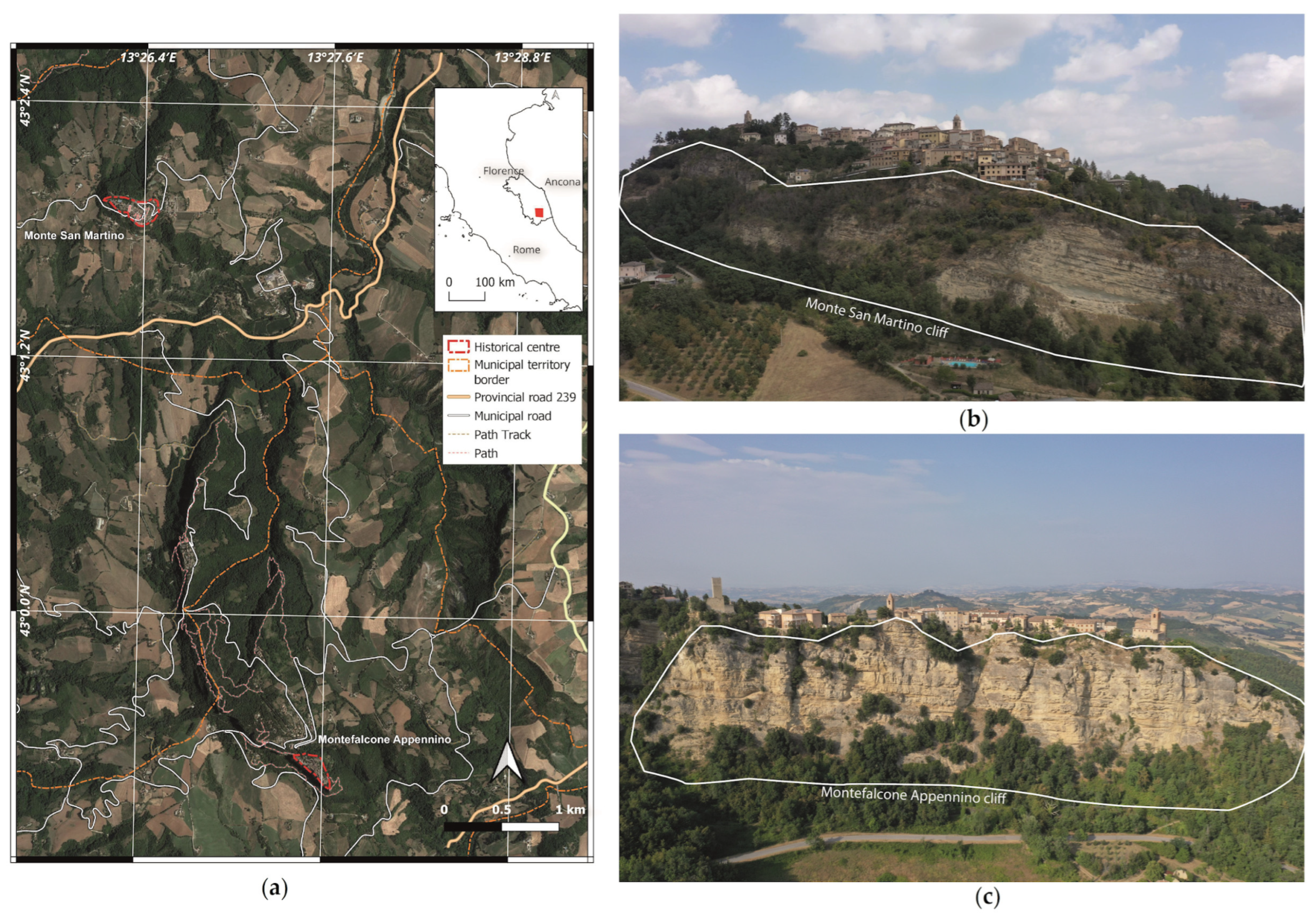
Figure 1. Geographical location of the studied villages in the Marche region (a) and the investigated cliffs at Monte San Martino village (b) and Montefalcone Appennino village (c).
Remotesensing 15 05574 g001
Figure 2. Geological map reduced in scale (1:25,000) from the Marche Region’s 1:10,000 scale geological cartography with a cross-section modified from Sheet 314 [16] of the geologic map of Italy, showing the general structural attitude of the Pliocene sedimentary body that forms the studied cliffs.
Remotesensing 15 05574 g002
Figure 3. (a) Sketch of the methodological approach used for data collection. (b) Temporal and spatial integration of the different techniques.
Remotesensing 15 05574 g003
Figure 4. VLOS maps (mm/year) for the periods of 1992–2000, 2003–2010 and 2011–2014 acquired by the ERS-1/2, ENVISAT and COSMO-SkyMed satellites in the study areas of Monte San Martino and Montefalcone Appennino. The white line indicates the boundaries of the investigated landslide that were previously mapped by the Italian landslide inventory named PAI.
Remotesensing 15 05574 g004
Figure 5. Geological map, structural features, and photographs stored during the process of digital field mapping (MUS: “Musone Sythem”—Holocene; FAA: “Argille Azzurre Formation”—Pliocene; FCO: “Argille a Colombacci Formation”—Messinian; LAG: “Laga Formation”—Messinian) of Monte San Martino (a) and Montefalcone Appennino areas (b).
Remotesensing 15 05574 g005
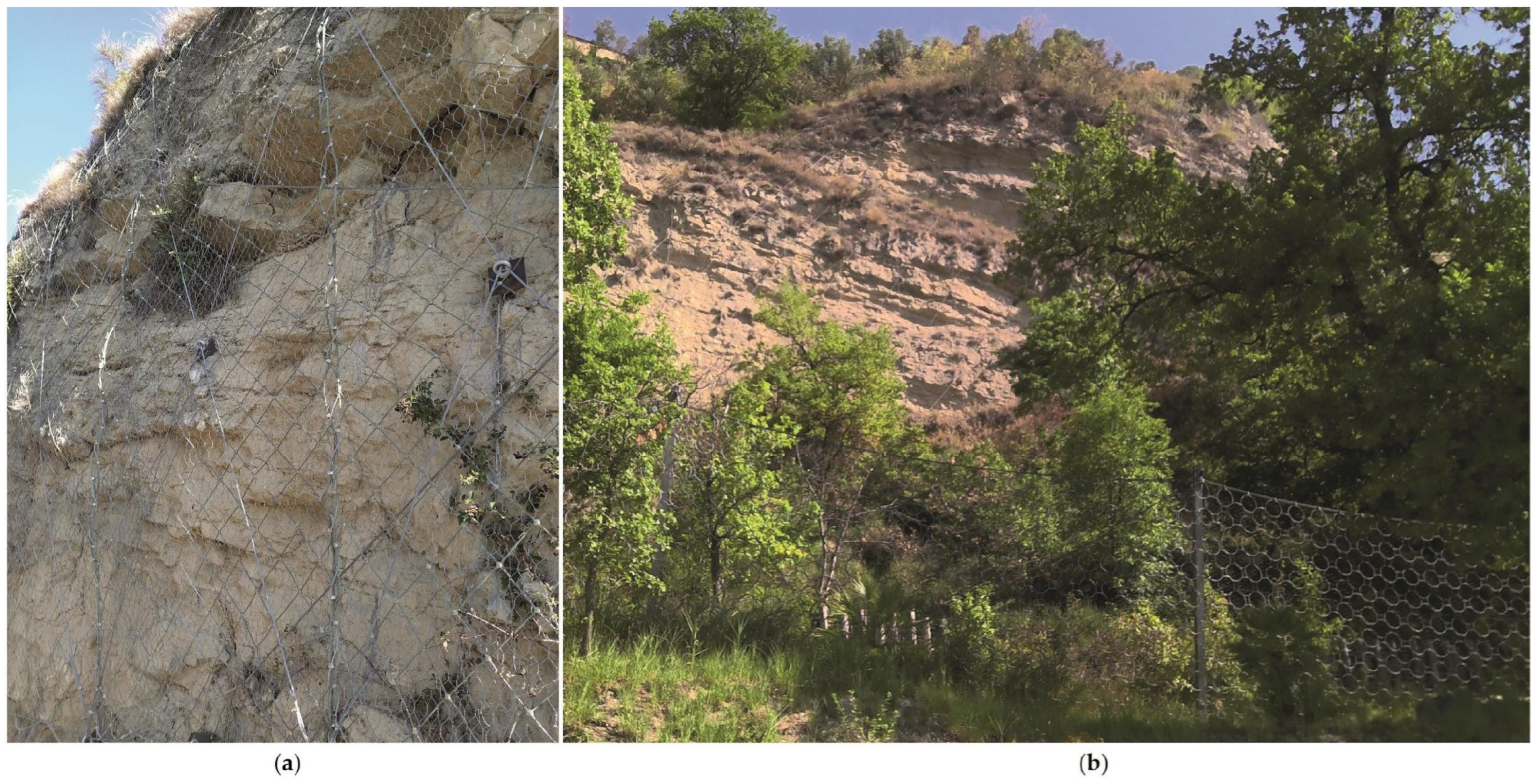
Figure 6. Example of rockfall barriers: rockfall protection net in Monte San Martino (a) and rockfall protection fence in Montefalcone Appennino (b).
Remotesensing 15 05574 g006
Figure 7. Slope map and the cliff areas of Monte San Martino (a) and Montefalcone Appennino (b).
Remotesensing 15 05574 g007
Figure 8. Aspect map and the cliff areas of Monte San Martino (a) and Montefalcone Appennino (b).
Remotesensing 15 05574 g008
Figure 9. Main structural lineaments affecting the cliffs of Monte San Martino (a) and Montefalcone Appennino (b).
Remotesensing 15 05574 g009
Figure 10. Profile curvature maps in the cliff areas of Monte San Martino (a) and Montefalcone Appennino (b), showing how a prevailing convexity characterizes the detachment area (d) while the accumulation area (a) is predominantly concave. The related boxplots show the distribution of the profile curvature values in the d and a cliff areas. The median line of the “detachment” box is above the value ‘0’, indicating the prevailing convexity of the land’s surface, while the median line of the “accumulation” box is below the value ‘0’, thus highlighting the prevailing concavity of the land’s surface.
Remotesensing 15 05574 g010
Figure 11. Location of the slopes’ safety works superimposed on the land use (land use map of the Marche Region at the scale of 1:10,000) in Montefalcone Appennino. The outlines of the four most representative profiles shown in the figure are also traced.
Remotesensing 15 05574 g011
Figure 12. Location of the slopes’ safety works superimposed on the land use (land use map of the Marche Region at the scale of 1:10,000) in Monte San Martino. The outlines of the four most representative profiles shown in the figure are also traced.
Remotesensing 15 05574 g012
Figure 13. (a) 3D model of the cliff in RGB colors. (b) Three-dimensional model of the cliff, with the dip directions of the slope faces (and joints) highlighted. (c) Sector of the slope where the intersection of S0, J1 and J2 brought about the detachment of a large rock block. (d) The same sector as shown in (c) with the dip directions of the slope faces (and joints) highlighted.
Remotesensing 15 05574 g013
Figure 14. VLOS (mm/year) for the period from 2011 to 2014 acquired by the COSMO-SkyMed ascending satellite in the area of Monte San Martino. The white lines represent the landslides mapped via the PAI. (b) LOS displacement time series of the movements detected in proximity to the village. The location of the measuring points is shown as a black circle in (a).
Remotesensing 15 05574 g014
Table 1. Details of the UAV photogrammetric survey.
Case StudyPhotosOverlapSide LapFlight ModeDistance
Monte San Martino190~80~80Manual~50
Montefalcone Appennino105~80~80Manual~70
Table 2. Characteristics of the SAR datasets, their processing and results.
SatelliteOrbitRevisit Time
(Days)
Incidence Angle (°)No. of SAR ImagesTime SpanGround Resolution
(m)
ERS1/2Ascending~35~23.0501992–200020 × 5
ERS1/2Descending~35~23.0551992–200020 × 5
ENVISATAscending~24~23.0502003–201020 × 5
ENVISATDescending~24~23.0382003–201020 × 5
COSMO-SkyMedAscending~1227352011–20143 × 3
COSMO-SkyMedDescending~1229472011–20143 × 3
Table 3. Orientation of the slopes and main discontinuity sets.
Case studySlope
dip/dip dir
S0
dip/dip dir
J1
dip/dip dir
J2
dip/dip dir
J3
dip/dip dir
Monte
San Martino
75/22010/8080/16080/26070/75
Montefalcone Appennino75/21020/7560/17070/23070/80
Disclaimer/Publisher’s Note: The statements, opinions and data contained in all publications are solely those of the individual author(s) and contributor(s) and not of MDPI and/or the editor(s). MDPI and/or the editor(s) disclaim responsibility for any injury to people or property resulting from any ideas, methods, instructions or products referred to in the content.