Large-Scale Surface Deformation Monitoring Using SBAS-InSAR and Intelligent Prediction in Typical Cities of Yangtze River Delta
Abstract
:1. Introduction
2. Materials and Methods
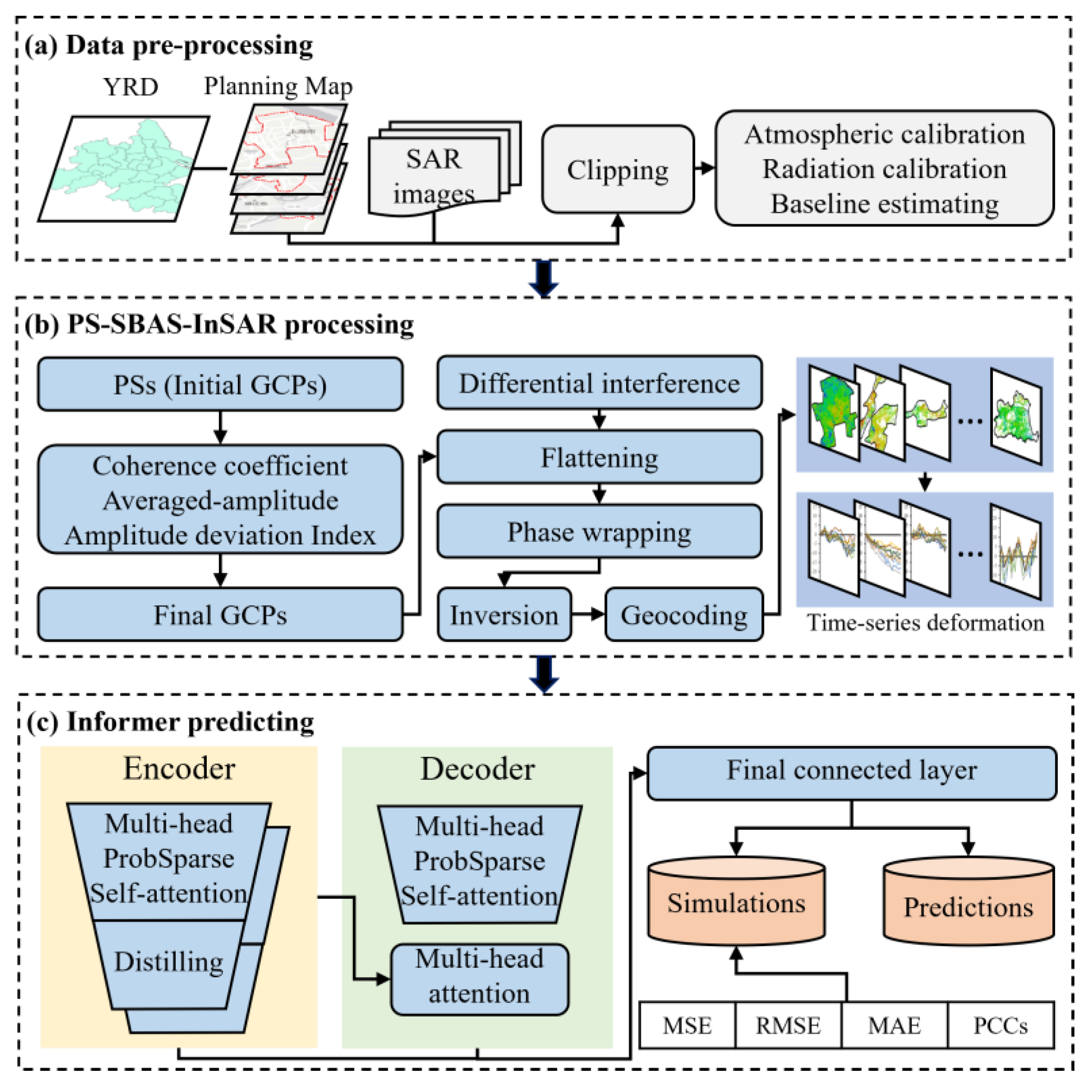
2.1. The PS-SBAS-InSAR Technology
2.2. The Landscape Metrics
2.3. The Informer Model
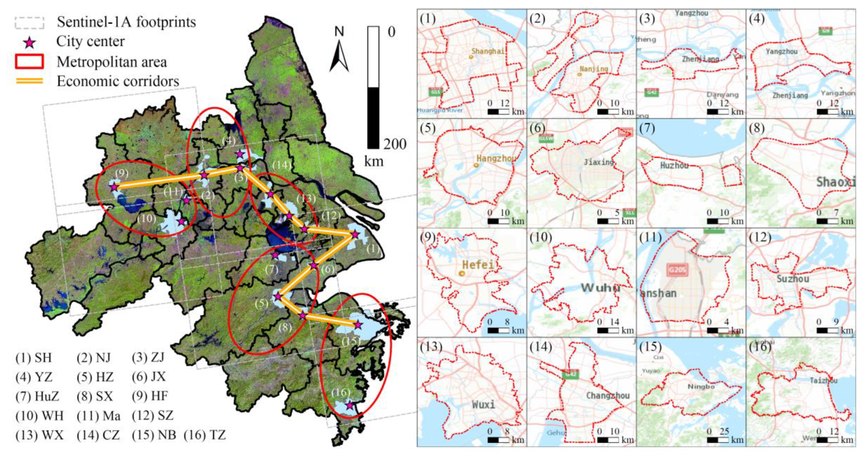
3. Study Area and Datasets
4. Results
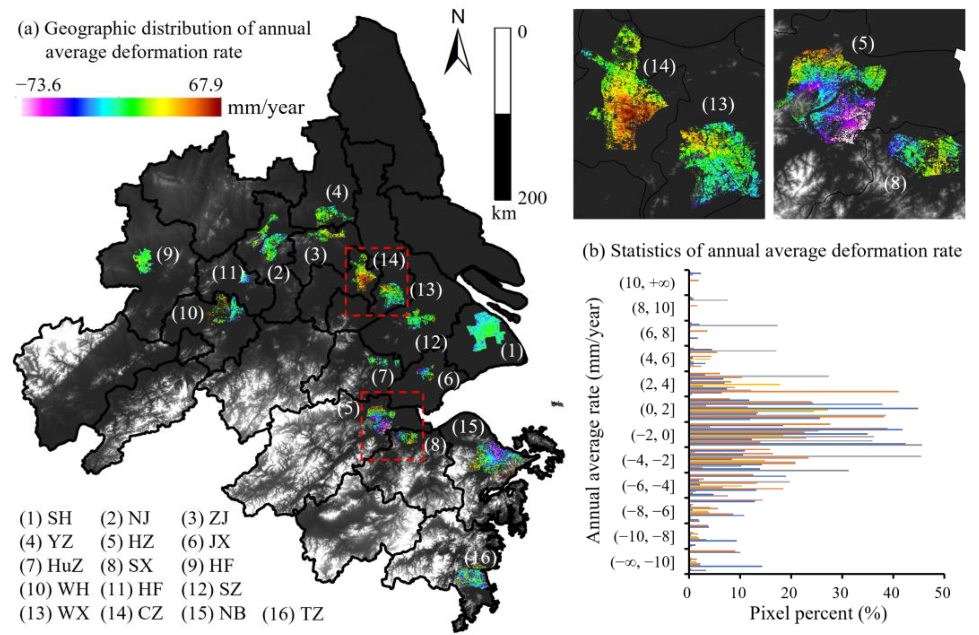
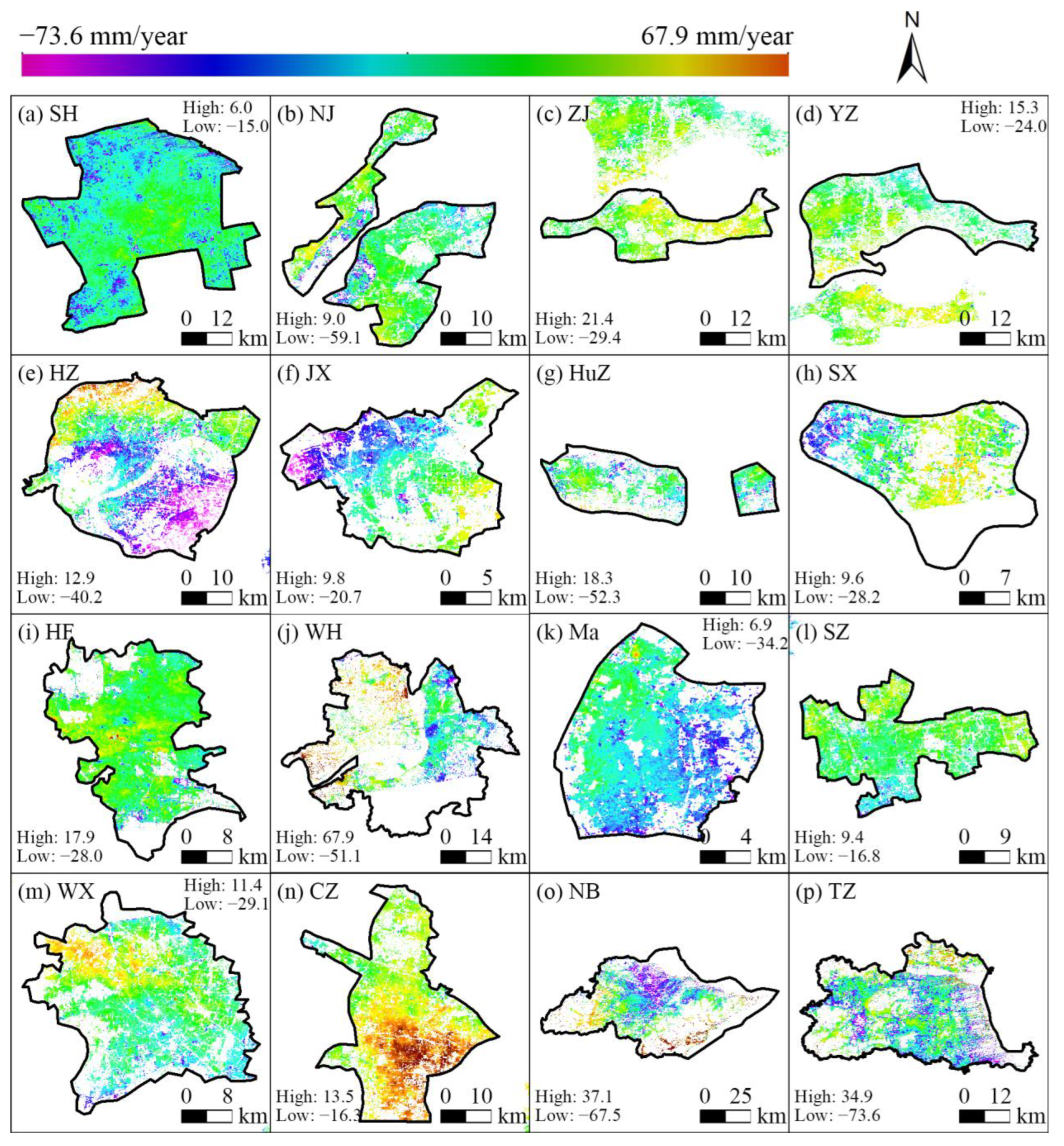
4.1. Deformation Results and Assessment
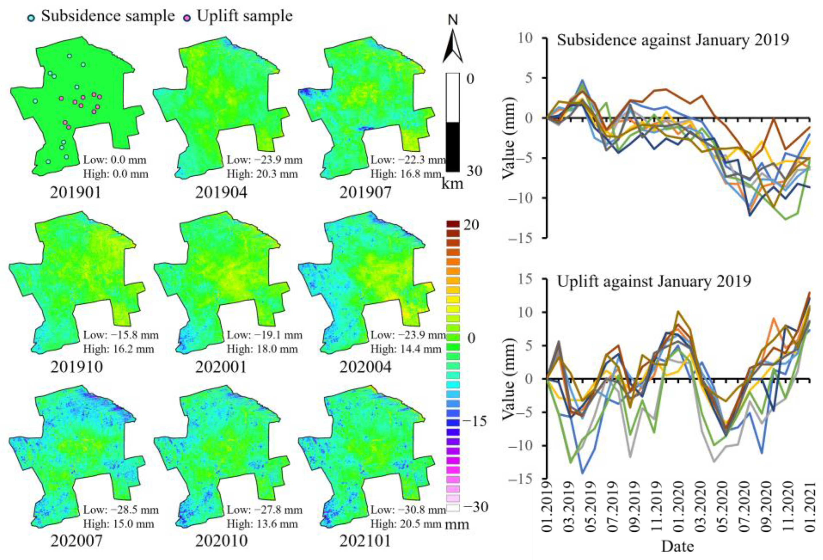
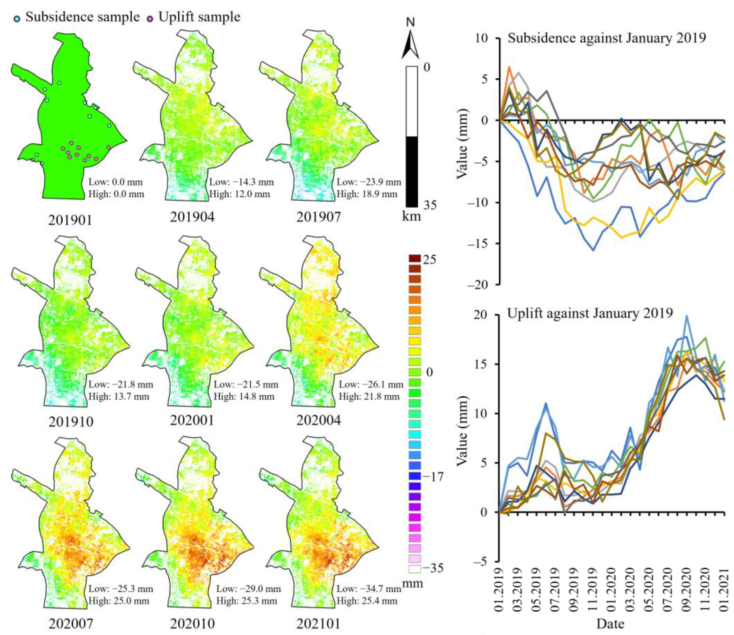
4.2. Deformation Time-Series Analysis
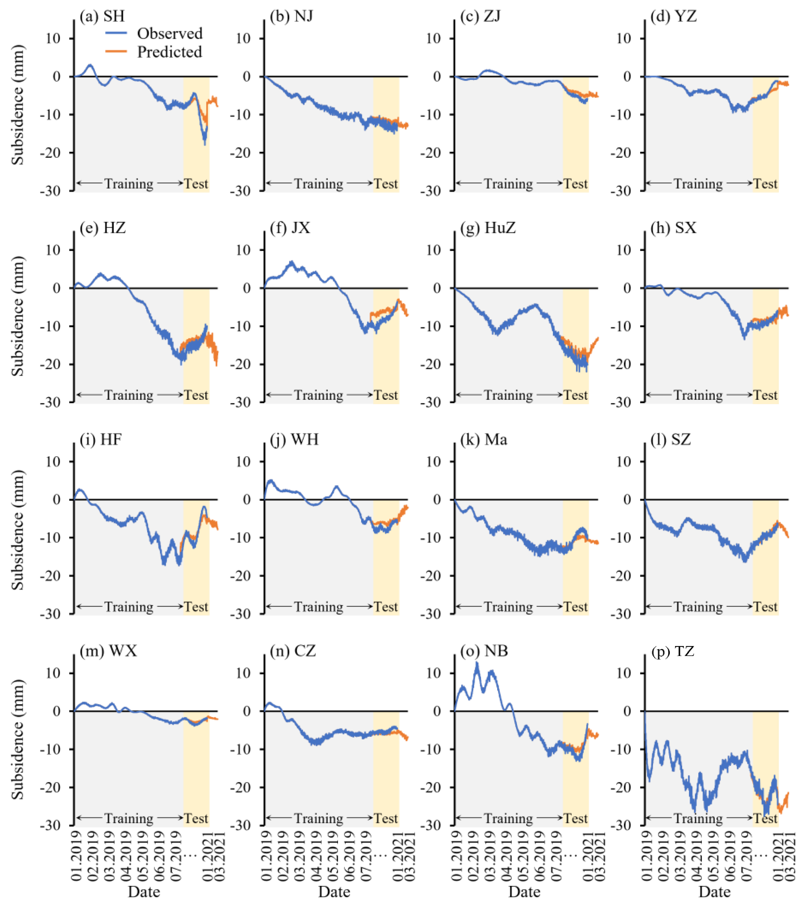
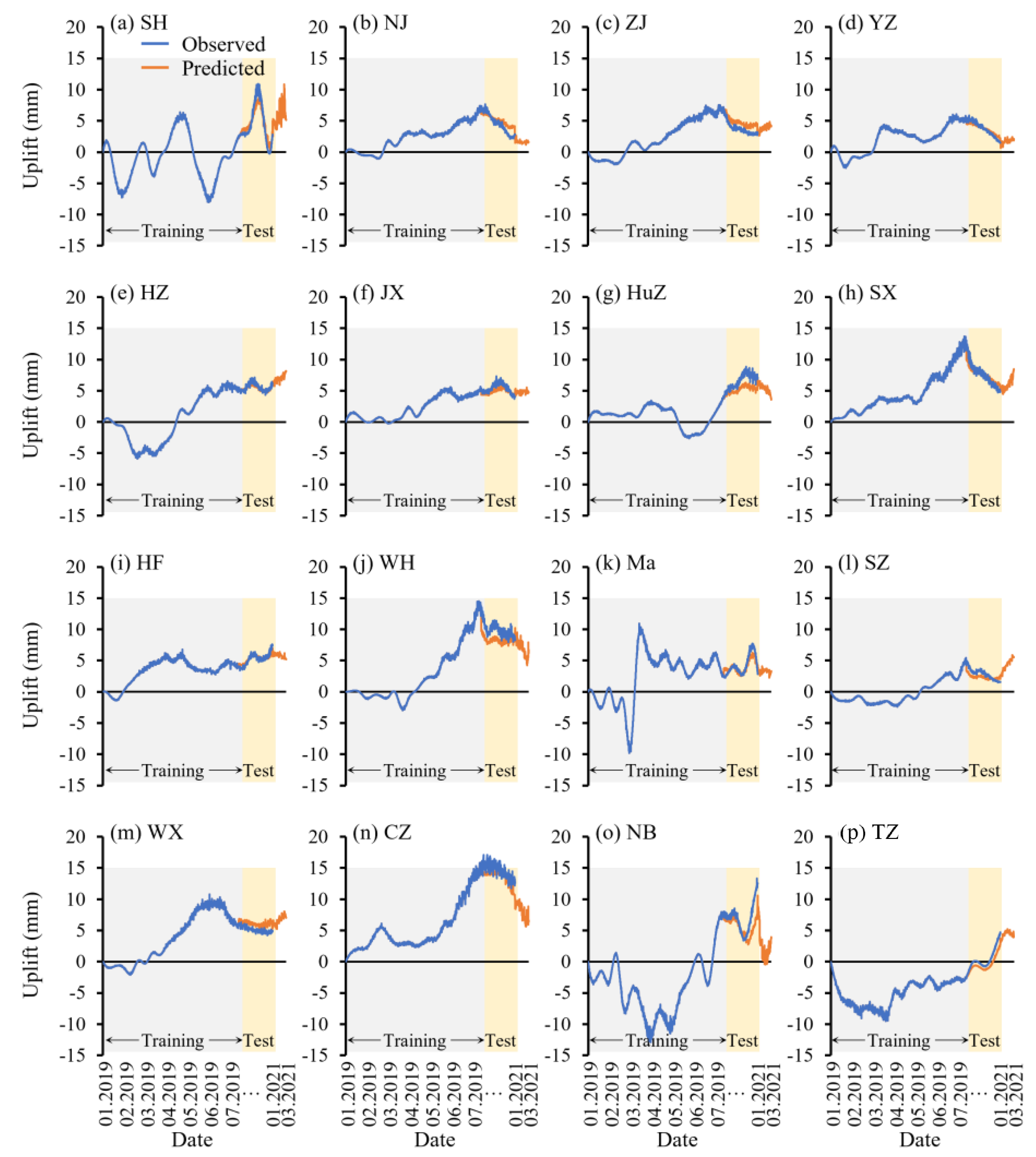
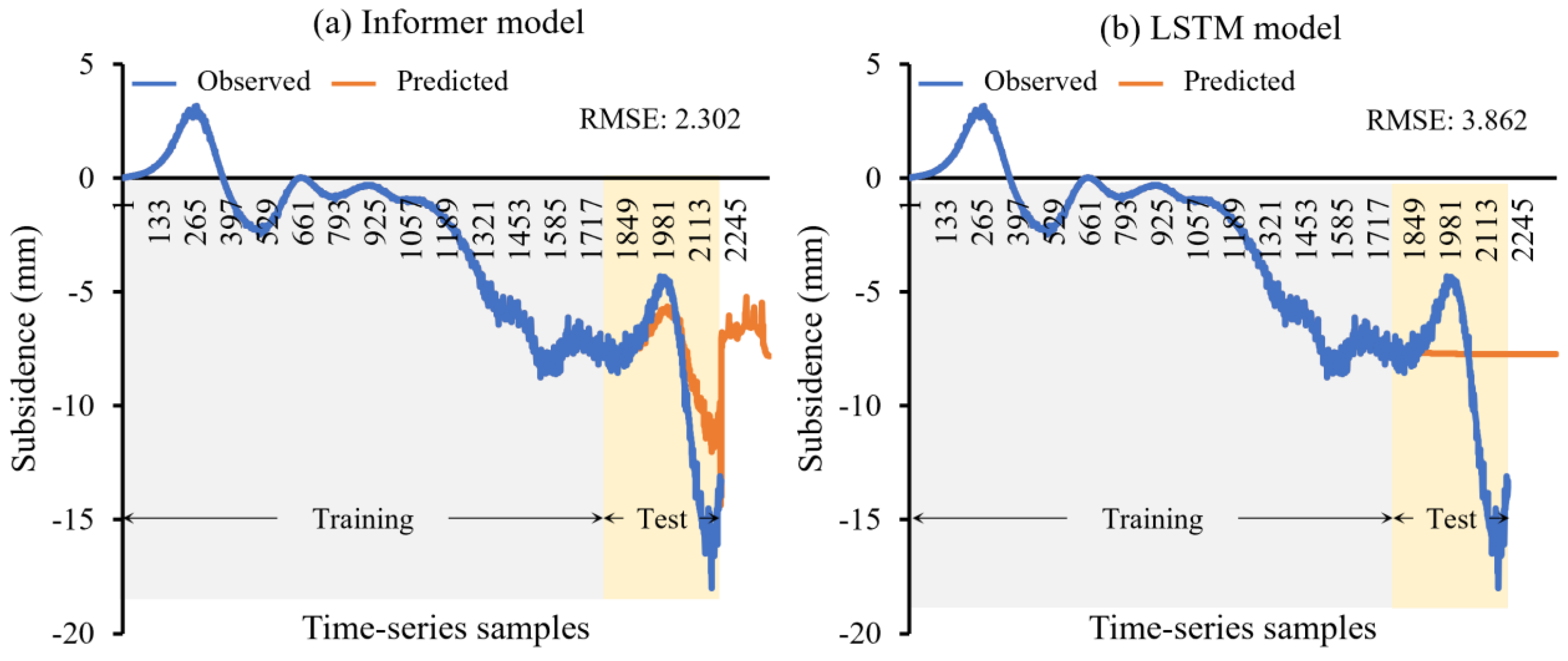
4.3. Future Deformation Prediction
5. Discussion
6. Conclusions
Author Contributions
Funding
Data Availability Statement
Conflicts of Interest
References
- Chaussard, E.; Wdowinski, S.; Cabral-Cano, E.; Amelung, F. Land subsidence in central Mexico detected by ALOS InSAR time-series. Remote Sens. Environ. 2014, 140, 94–106. [Google Scholar] [CrossRef]
- Costantini, M.; Ferretti, A.; Minati, F.; Falco, S.; Trillo, F.; Colombo, D.; Novali, F.; Malvarosa, F.; Mammone, C.; Vecchioli, F.; et al. Analysis of surface deformations over the whole Italian territory by interferometric processing of ERS, Envisat and COSMO-SkyMed radar data. Remote Sens. Environ. 2017, 202, 250–275. [Google Scholar] [CrossRef]
- Han, P.; Yang, X.; Bai, L.; Sun, Q. The monitoring and analysis of the coastal lowland subsidence in the southern Hangzhou Bay with an advanced time-series InSAR method. Acta Oceanol. Sin. 2017, 36, 110–118. [Google Scholar] [CrossRef]
- Zhang, B.; Wang, R.; Deng, Y.; Ma, P.; Lin, H.; Wang, J. Mapping the Yellow River Delta land subsidence with multitemporal SAR interferometry by exploiting both persistent and distributed scatterers. ISPRS J. Photogramm. Remote Sens. 2019, 148, 157–173. [Google Scholar] [CrossRef]
- Mahmoudpour, M.; Khamehchiyan, M.; Nikudel, M.R.; Ghassemi, M.R. Numerical simulation and prediction of regional land subsidence caused by groundwater exploitation in the southwest plain of Tehran, Iran. Eng. Geol. 2016, 201, 6–28. [Google Scholar] [CrossRef]
- Chaussard, E.; Amelung, F.; Abidin, H.; Hong, S.-H. Sinking cities in Indonesia: ALOS PALSAR detects rapid subsidence due to groundwater and gas extraction. Remote Sens. Environ. 2013, 128, 150–161. [Google Scholar] [CrossRef]
- Chen, G.; Zhang, Y.; Zeng, R.; Yang, Z.; Chen, X.; Zhao, F.; Meng, X. Detection of Land Subsidence Associated with Land Creation and Rapid Urbanization in the Chinese Loess Plateau Using Time Series InSAR: A Case Study of Lanzhou New District. Remote Sens. 2018, 10, 270. [Google Scholar] [CrossRef]
- Hooper, A.; Bekaert, D.; Spaans, K.; Arikan, M. Recent advances in SAR interferometry time series analysis for measuring crustal deformation. Tectonophysics 2012, 514, 1–13. [Google Scholar] [CrossRef]
- Wang, J.; Feng, Y.; Wang, R.; Tong, X.; Chen, S.; Lei, Z.; Li, P.; Xi, M. Evaluation of typhoon-induced inundation losses associated with LULC using multi-temporal SAR and optical images. Geomat. Nat. Hazards Risk 2022, 13, 2227–2251. [Google Scholar] [CrossRef]
- Wu, J.; Hu, F. Monitoring Ground Subsidence Along the Shanghai Maglev Zone Using TerraSAR-X Images. IEEE Geosci. Remote Sens. Lett. 2017, 14, 117–121. [Google Scholar] [CrossRef]
- Abidin, H.Z.; Andreas, H.; Gumilar, I.; Fukuda, Y.; Pohan, Y.; Deguchi, T. Land subsidence of Jakarta (Indonesia) and its relation with urban development. Nat. Hazards 2011, 59, 1753–1771. [Google Scholar] [CrossRef]
- Chen, J.; Wu, J.; Zhang, L.; Zou, J.; Liu, G.; Zhang, R. Deformation Trend Extraction Based on Multi-Temporal InSAR in Shanghai. Remote Sens. 2013, 5, 1774–1786. [Google Scholar] [CrossRef]
- Ferretti, A.; Prati, C.; Rocca, F. Permanent scatterers in SAR interferometry. IEEE Trans. Geosci. Remote Sens. 2001, 39, 8–20. [Google Scholar] [CrossRef]
- Berardino, P.; Fornaro, G.; Lanari, R.; Sansosti, E. A New Algorithm for Surface Deformation Monitoring Based on Small Baseline Differential SAR Interferograms. IEEE Trans. Geosci. Remote Sens. 2002, 40, 2375–2383. [Google Scholar] [CrossRef]
- Casu, F.; Manzo, M.; Lanari, R. A quantitative assessment of the SBAS algorithm performance for surface deformation retrieval from DInSAR data. Remote Sens. Environ. 2006, 102, 195–210. [Google Scholar] [CrossRef]
- Feng, Y.; Lei, Z.; Tong, X.; Xi, M.; Li, P. An Improved Geometric Calibration Model for Spaceborne Sar Systems with a Case Study of Large-Scale Gaofen-3 Images. IEEE J. Sel. Top. Appl. Earth Obs. Remote Sens. 2022, 15, 6928–6942. [Google Scholar] [CrossRef]
- Feng, Y.; Zhou, Y.; Chen, Y.; Li, P.; Xi, M.; Tong, X. Automatic selection of permanent scatterers-based GCPs for refinement and reflattening in InSAR DEM generation. Int. J. Digit. Earth 2022, 15, 954–974. [Google Scholar] [CrossRef]
- Phi, T.H.; Strokova, L.A. Prediction maps of land subsidence caused by groundwater exploitation in Hanoi, Vietnam. Resour. Effic. Technol. 2015, 1, 80–89. [Google Scholar] [CrossRef]
- Shi, X.; Wu, J.; Ye, S.; Zhang, Y.; Xue, Y.; Wei, Z.; Li, Q.; Yu, J. Regional land subsidence simulation in Su-Xi-Chang area and Shanghai City, China. Eng. Geol. 2008, 100, 27–42. [Google Scholar] [CrossRef]
- Zhang, Y.; Zhang, Y. Land Subsidence Prediction Method of Power Cables Pipe Jacking Based on the Peck Theory. Adv. Mater. Res. 2013, 634-638, 3721–3724. [Google Scholar] [CrossRef]
- Wang, Y.; Yang, G. Prediction of Composite Foundation Settlement Based on Multi-Variable Gray Model. Appl. Mech. Mater. 2014, 580–583, 669–673. [Google Scholar] [CrossRef]
- Vaswani, A.; Shazeer, N.; Parmar, N.; Uszkoreit, J.; Jones, L.; Gomez, A.N.; Kaiser, L.; Polosukhin, I. Attention Is All You Need. Adv. Neural Inf. Process. Syst. 2017, 30, 5998–6008. [Google Scholar]
- Zhou, H.; Zhang, S.; Peng, J.; Zhang, S.; Zhang, W. Informer: Beyond efficient transformer for long sequence time-series forecasting. In Proceedings of the AAAI Conference on Artificial Intelligence, San Francisco, CA, USA, 2–9 February 2021; pp. 11106–11115. [Google Scholar]
- Feng, Y.; Gao, C.; Tong, X.; Chen, S.; Lei, Z.; Wang, J. Spatial patterns of land surface temperature and their influencing factors: A case study in Suzhou, China. Remote Sens. 2019, 11, 182. [Google Scholar] [CrossRef]
- Wang, R.; Feng, Y.; Wei, Y.; Tong, X.; Zhai, S.; Zhou, Y.; Wu, P. A comparison of proximity and accessibility drivers in simulating dynamic urban growth. Trans. GIS 2021, 25, 923–947. [Google Scholar] [CrossRef]
- Chen, F.; Lin, H.; Zhang, Y.; Lu, Z. Ground subsidence geo-hazards induced by rapid urbanization: Implications from InSAR observation and geological analysis. Nat. Hazards Earth Syst. Sci. 2012, 12, 935–942. [Google Scholar] [CrossRef]
- Wang, J.; Gao, W.; Xu, S.; Yu, L. Evaluation of the combined risk of sea level rise, land subsidence, and storm surges on the coastal areas of Shanghai, China. Clim. Chang. 2012, 115, 537–558. [Google Scholar] [CrossRef]
- Shun, Y.; Xin, Z.; Li, L. Combination evaluation and case analysis of vulnerability of storm surge in coastal provinces of China. Acta Oceanogr. 2016, 38, 16–24. [Google Scholar]
- Fu, C.; Yu, F.; Wang, P.; Liu, Q.; Dong, J. A study on extratropical storm surge disaster risk assessment at Binhai New Area. Acta Oceanol. Sin. 2013, 35, 55–62. [Google Scholar]
- Dai, K.; Liu, G.; Li, Z.; Li, T.; Yu, B.; Wang, X. Extracting Vertical Displacement Rates in Shanghai (China) with Multi-Platform SAR Images. Remote Sens. 2015, 7, 9542–9562. [Google Scholar] [CrossRef]
- Foroughnia, F.; Nemati, S.; Maghsoudi, Y.; Perissin, D. An iterative PS-InSAR method for the analysis of large spatio-temporal baseline data stacks for land subsidence estimation. Int. J. Appl. Earth Obs. Geoinf. 2019, 74, 248–258. [Google Scholar] [CrossRef]
- Crosetto, M.; Monserrat, O.; Cuevas-González, M.; Devanthéry, N.; Crippa, B. Persistent Scatterer Interferometry: A review. ISPRS J. Photogramm. Remote Sens. 2016, 115, 78–89. [Google Scholar] [CrossRef]
- Bateson, L.; Cigna, F.; Boon, D.; Sowter, A. The application of the Intermittent SBAS (ISBAS) InSAR method to the South Wales Coalfield, UK. Int. J. Appl. Earth Obs. Geoinf. 2015, 34, 249–257. [Google Scholar] [CrossRef]
- McGarigal, K.C.S.; Ene, E. FRAGSTATS v4: Spatial Pattern Analysis Program for Categorical and Continuous Maps; Computer Software Program; University of Massachusetts: Amherst, MA, USA, 2012; Available online: http://www.umass.edu/landeco/research/fragstats/fragstats.html (accessed on 18 September 2021).
- Alhamad, M.N.; Alrababah, M.A.; Feagin, R.A.; Gharaibeh, A.A. Mediterranean drylands: The effect of grain size and domain of scale on landscape metrics. Ecol. Indic. 2011, 11, 611–621. [Google Scholar] [CrossRef]
- Fang, C.; Li, G.; Wang, S. Changing and Differentiated Urban Landscape in China: Spatiotemporal Patterns and Driving Forces. Environ. Sci. Technol. 2016, 50, 2217–2227. [Google Scholar] [CrossRef]
- Feng, Y.; Liu, Y. Fractal dimension as an indicator for quantifying the effects of changing spatial scales on landscape metrics. Ecol. Indic. 2015, 53, 18–27. [Google Scholar] [CrossRef]
- Li, S.; Jin, X.; Xuan, Y.; Zhou, X.; Chen, W.; Wang, Y.X.; Yan, X. Enhancing the Locality and Breaking the Memory Bottleneck of Transformer on Time Series Forecasting. Adv. Neural Inform. Process. Syst. 2020, 32. [Google Scholar] [CrossRef]
- The State Council of the People’s Republic of China. The Outline of the Integrated Regional Development of the Yangtze River Delta; The State Council of the People’s Republic of China: Beijing, China, 2019. [Google Scholar]
- Xu, Y.-S.; Ma, L.; Du, Y.-J.; Shen, S.-L. Analysis of urbanisation-induced land subsidence in Shanghai. Nat. Hazards 2012, 63, 1255–1267. [Google Scholar] [CrossRef]
- Thoennessen, U. High-resolution SAR data: New opportunities and challenges for the analysis of urban areas. Radar Sonar Navig. IEE Proc. 2006, 153, 294–300. [Google Scholar]
- Cigna, F.; Osmanoğlu, B.; Cabral-Cano, E.; Dixon, T.H.; Ávila-Olivera, J.A.; Garduño-Monroy, V.H.; DeMets, C.; Wdowinski, S. Monitoring land subsidence and its induced geological hazard with Synthetic Aperture Radar Interferometry: A case study in Morelia, Mexico. Remote Sens. Environ. 2012, 117, 146–161. [Google Scholar] [CrossRef]
- Castellazzi, P.; Garfias, J.; Martel, R.; Brouard, C.; Rivera, A. InSAR to support sustainable urbanization over compacting aquifers: The case of Toluca Valley, Mexico. Int. J. Appl. Earth Obs. Geoinf. 2017, 63, 33–44. [Google Scholar] [CrossRef]
- Yao, G.; Ke, C.-Q.; Zhang, J.; Lu, Y.; Zhao, J.; Lee, H. Surface deformation monitoring of Shanghai based on ENVISAT ASAR and Sentinel-1A data. Environ. Earth Sci. 2019, 78, 1–13. [Google Scholar] [CrossRef]
- Hill, P.; Biggs, J.; Ponce-López, V.; Bull, D. Time-Series Prediction Approaches to Forecasting Deformation in Sentinel-1 InSAR Data. J. Geophys. Res. Solid Earth 2021, 126, e2020JB020176. [Google Scholar] [CrossRef]



| Metric | Abbreviation | Category | Description |
|---|---|---|---|
| Largest patch index | LPI | Area-Edge | Indicates the percentage of the largest patches of a given type over the entire landscape area. |
| Edge density | ED | Area-Edge | Refers to the length of the edge between patches of landscape elements. |
| Perimeter–area fractal dimension index | PAFRAC | Shape | Reflects the complexity of the patch shape. |
| Landscape shape index | LSI | Aggregation | Reflects the complexity of the landscape shape. |
| Landscape division index | DIVISION | Aggregation | Represents the degree of separation between patches of a certain class. |
| Aggregation index | AI | Aggregation | Indicates connectivity between patches of the same class. |
| Category | City | Abbreviation | Sentinel-1A Footprint | Angle of Incidence |
|---|---|---|---|---|
| Core city | Shanghai | SH | 171-96 | 39.032° |
| Nanjing metropolitan area | Nanjing | NJ | 69-99 | 39.037° |
| Zhenjiang | ZJ | 69-99 | 39.037° | |
| Yangzhou | YZ | 69-99 | 39.037° | |
| Hangzhou metropolitan area | Hangzhou | HZ | 69-94 | 39.083° |
| Jiaxing | JX | 69-94 | 39.083° | |
| Huzhou | HuZ | 69-94 | 39.083° | |
| Shaoxing | SX | 69-94 | 39.083° | |
| Hefei metropolitan area | Hefei | HF | 142-101 | 39.007° |
| Wuhu | WH | 142-96 | 39.072° | |
| Maanshan | Ma | 69-99 | 39.037° | |
| Su-Xi-Chang metropolitan area | Suzhou | SZ | 69-99 | 39.037° |
| Wuxi | WX | 69-99 | 39.037° | |
| Changzhou | CZ | 69-99 | 39.037° | |
| Ningbo metropolitan area | Ningbo | NB | 171-91 | 38.867° |
| Taizhou | TZ | 171-91 | 38.867° |
| Image No. | Acquisition Date | ||
|---|---|---|---|
| Orbital No. 69 | Orbital No. 142 | Orbital No. 171 | |
| 1 | 17 January 2019 | 22 January 2019 | 24 January 2019 |
| 2 | 22 February 2019 | 27 February 2019 | 17 February 2019 |
| 3 | 18 March 2019 | 23 March 2019 | 13 March 2019 |
| 4 | 11 April 2019 | 16 April 2019 | 6 April 2019 |
| 5 | 29 May 2019 | 22 May 2019 | 24 May 2019 |
| 6 | 22 June 2019 | 27 June 2019 | 17 June 2019 |
| 7 | 16 July 2019 | 21 July 2019 | 11 July 2019 |
| 8 | 21 August 2019 | 26 August 2019 | 16 August 2019 |
| 9 | 26 September 2019 | 19 September 2019 | 21 September 2019 |
| 10 | 20 October 2019 | 25 October 2019 | 15 October 2019 |
| 11 | 13 November 2019 | 18 November 2019 | 8 November 2019 |
| 12 | 19 December 2019 | 24 December 2019 | 14 December 2019 |
| 13 | 12 January 2020 | 17 January 2020 | 7 January 2020 |
| 14 | 17 February 2020 | 22 February 2020 | 12 February 2020 |
| 15 | 24 March 2020 | 29 March 2020 | 19 March 2020 |
| 16 | 17 April 2020 | 22 April 2020 | 12 April 2020 |
| 17 | 23 May 2020 | 28 May 2020 | 18 May 2020 |
| 18 | 16 June 2020 | 21 June 2020 | 11 June 2020 |
| 19 | 22 July 2020 | 27 July 2020 | 17 July 2020 |
| 20 | 15 August 2020 | 20 August 2020 | 10 August 2020 |
| 21 | 20 September 2020 | 25 September 2020 | 15 September 2020 |
| 22 | 14 October 2020 | 19 October 2020 | 9 October 2020 |
| 23 | 7 November 2020 | 12 November 2020 | 2 November 2020 |
| 24 | 13 December 2020 | 18 December 2020 | 8 December 2020 |
| 25 | 18 January 2021 | 23 January 2021 | 13 January 2021 |
| Category | City | Average Deformation Rate (mm/year) | Estimated Residuals (mm/year) | |||
|---|---|---|---|---|---|---|
| Low | High | Mean | Mean | Standard Deviation | ||
| Core city | SH | −14.988 | 6.004 | −1.817 | 2.103 | 1.922 |
| Nanjing metropolitan area | NJ | −59.050 | 9.016 | −1.345 | 2.486 | 1.139 |
| ZJ | −29.431 | 21.386 | 1.359 | 2.843 | 1.344 | |
| YZ | −24.027 | 15.314 | −0.034 | 2.635 | 1.380 | |
| Hangzhou metropolitan area | HZ | −40.213 | 12.898 | −3.937 | 1.961 | 0.916 |
| JX | −20.627 | 9.832 | −2.511 | 2.379 | 0.969 | |
| HuZ | −52.280 | 18.304 | −1.824 | 2.516 | 1.072 | |
| SX | −28.226 | 9.599 | −0.697 | 2.647 | 1.611 | |
| Hefei metropolitan area | HF | −28.017 | 17.880 | −0.152 | 2.955 | 1.350 |
| WH | −51.116 | 67.897 | −0.956 | 3.274 | 1.168 | |
| Ma | −34.247 | 6.921 | −2.972 | 3.343 | 1.571 | |
| Su-Xi-Chang metropolitan area | SZ | −16.831 | 9.391 | −0.312 | 2.203 | 1.230 |
| WX | −29.147 | 11.381 | −0.282 | 2.337 | 1.737 | |
| CZ | −16.259 | 13.532 | 3.832 | 2.417 | 1.223 | |
| Ningbo metropolitan area | NB | −67.455 | 37.083 | −3.247 | 3.514 | 1.909 |
| TZ | −73.640 | 34.860 | −3.551 | 3.355 | 1.577 | |
| City | Subsidence | Uplift | ||||||||||
|---|---|---|---|---|---|---|---|---|---|---|---|---|
| Area-Edge | Shape | Aggregation | Area-Edge | Shape | Aggregation | |||||||
| LPI (%) | ED (m/ha) | PAFRAC | LSI | DIVISION | AI (%) | LPI (%) | ED (m/ha) | PAFRAC | LSI | DIVISION | AI (%) | |
| SH | 9.137 | 25.745 | 1.263 | 66.69 | 0.990 | 93.741 | 0.026 | 1.519 | 1.255 | 30.397 | 1.000 | 78.069 |
| NJ | 0.765 | 11.281 | 1.261 | 61.849 | 1.000 | 88.521 | 0.346 | 4.196 | 1.267 | 40.356 | 1.000 | 86.967 |
| ZJ | 0.046 | 3.654 | 1.196 | 27.98 | 1.000 | 77.849 | 1.801 | 18.892 | 1.265 | 42.553 | 0.999 | 90.016 |
| YZ | 0.098 | 9.165 | 1.223 | 57.061 | 1.000 | 79.217 | 0.414 | 9.563 | 1.26 | 51.796 | 1.000 | 83.596 |
| HZ | 6.633 | 28.834 | 1.274 | 64.266 | 0.993 | 91.756 | 0.448 | 9.344 | 1.268 | 43.079 | 1.000 | 88.641 |
| JX | 5.784 | 22.396 | 1.273 | 34.192 | 0.996 | 90.848 | 0.386 | 5.856 | 1.227 | 20.558 | 1.000 | 87.533 |
| HuZ | 0.521 | 19.259 | 1.256 | 47.76 | 1.000 | 85.650 | 0.124 | 3.241 | 1.202 | 24.258 | 1.000 | 78.181 |
| SX | 2.331 | 14.676 | 1.265 | 36.628 | 0.999 | 88.549 | 1.136 | 11.861 | 1.259 | 33.508 | 1.000 | 88.190 |
| HF | 0.259 | 15.051 | 1.277 | 57.557 | 1.000 | 81.654 | 0.261 | 12.367 | 1.271 | 50.56 | 1.000 | 82.807 |
| WH | 1.062 | 11.967 | 1.247 | 67.633 | 1.000 | 88.582 | 0.156 | 9.659 | 1.228 | 71.2 | 1.000 | 84.280 |
| Ma | 21.353 | 51.903 | 1.295 | 37.896 | 0.954 | 90.950 | 0.093 | 1.224 | 1.199 | 9.266 | 1.000 | 78.197 |
| SZ | 0.772 | 11.434 | 1.245 | 44.454 | 1.000 | 85.050 | 0.163 | 7.334 | 1.261 | 37.496 | 1.000 | 83.475 |
| WX | 0.316 | 15.628 | 1.25 | 57.279 | 1.000 | 86.054 | 2.505 | 10.121 | 1.252 | 39.172 | 0.999 | 90.016 |
| CZ | 0.068 | 1.518 | 1.195 | 24.082 | 1.000 | 79.840 | 11.851 | 26.357 | 1.258 | 60.167 | 0.986 | 92.637 |
| NB | 6.103 | 16.099 | 1.279 | 92.438 | 0.996 | 92.047 | 0.219 | 8.330 | 1.24 | 86.289 | 1.000 | 86.608 |
| TZ | 3.757 | 33.883 | 1.3 | 86.533 | 0.998 | 89.427 | 0.083 | 13.720 | 1.262 | 78.294 | 1.000 | 78.599 |
| City | Subsidence | Uplift | ||||||
|---|---|---|---|---|---|---|---|---|
| MSE (mm/year) | RMSE (mm/year) | MAE (mm/year) | PCCs | MSE (mm/year) | RMSE (mm/year) | MAE (mm/year) | PCCs | |
| SH | 5.298 | 2.302 | 1.547 | 0.963 | 1.167 | 1.080 | 0.899 | 0.980 |
| NJ | 1.265 | 1.125 | 1.048 | 0.953 | 0.796 | 0.892 | 0.745 | 0.986 |
| ZJ | 1.034 | 1.017 | 0.929 | 0.998 | 1.123 | 1.060 | 1.000 | 0.933 |
| YZ | 0.890 | 0.944 | 0.647 | 0.978 | 0.185 | 0.430 | 0.374 | 0.992 |
| HZ | 3.127 | 1.768 | 1.610 | 0.870 | 0.089 | 0.299 | 0.241 | 0.946 |
| JX | 5.989 | 2.447 | 2.226 | 0.782 | 0.358 | 0.598 | 0.511 | 0.906 |
| HuZ | 4.081 | 2.020 | 1.968 | 0.969 | 2.298 | 1.516 | 1.377 | 0.964 |
| SX | 1.510 | 1.229 | 1.079 | 0.298 | 0.524 | 0.724 | 0.541 | 0.987 |
| HF | 2.599 | 1.612 | 1.383 | 0.994 | 0.148 | 0.384 | 0.294 | 0.956 |
| WH | 1.769 | 1.330 | 1.181 | 0.754 | 3.225 | 1.796 | 1.666 | 0.690 |
| Ma | 1.233 | 1.111 | 0.924 | 0.978 | 0.533 | 0.730 | 0.566 | 0.928 |
| SZ | 0.384 | 0.620 | 0.504 | 0.954 | 0.608 | 0.780 | 0.697 | 0.819 |
| WX | 0.142 | 0.377 | 0.305 | 0.955 | 1.134 | 1.065 | 0.998 | 0.596 |
| CZ | 0.528 | 0.727 | 0.570 | 0.587 | 1.957 | 1.399 | 1.217 | 0.783 |
| NB | 1.846 | 1.359 | 1.144 | 0.943 | 4.485 | 2.118 | 1.512 | 0.651 |
| TZ | 1.000 | 1.000 | 0.837 | 0.941 | 0.945 | 0.972 | 0.869 | 0.996 |
Disclaimer/Publisher’s Note: The statements, opinions and data contained in all publications are solely those of the individual author(s) and contributor(s) and not of MDPI and/or the editor(s). MDPI and/or the editor(s) disclaim responsibility for any injury to people or property resulting from any ideas, methods, instructions or products referred to in the content. |
© 2023 by the authors. Licensee MDPI, Basel, Switzerland. This article is an open access article distributed under the terms and conditions of the Creative Commons Attribution (CC BY) license (https://creativecommons.org/licenses/by/4.0/).
Share and Cite
Wang, R.; Feng, Y.; Tong, X.; Li, P.; Wang, J.; Tang, P.; Tang, X.; Xi, M.; Zhou, Y. Large-Scale Surface Deformation Monitoring Using SBAS-InSAR and Intelligent Prediction in Typical Cities of Yangtze River Delta. Remote Sens. 2023, 15, 4942. https://doi.org/10.3390/rs15204942
Wang R, Feng Y, Tong X, Li P, Wang J, Tang P, Tang X, Xi M, Zhou Y. Large-Scale Surface Deformation Monitoring Using SBAS-InSAR and Intelligent Prediction in Typical Cities of Yangtze River Delta. Remote Sensing. 2023; 15(20):4942. https://doi.org/10.3390/rs15204942
Chicago/Turabian StyleWang, Rong, Yongjiu Feng, Xiaohua Tong, Pengshuo Li, Jiafeng Wang, Panli Tang, Xiaoyan Tang, Mengrong Xi, and Yi Zhou. 2023. "Large-Scale Surface Deformation Monitoring Using SBAS-InSAR and Intelligent Prediction in Typical Cities of Yangtze River Delta" Remote Sensing 15, no. 20: 4942. https://doi.org/10.3390/rs15204942
APA StyleWang, R., Feng, Y., Tong, X., Li, P., Wang, J., Tang, P., Tang, X., Xi, M., & Zhou, Y. (2023). Large-Scale Surface Deformation Monitoring Using SBAS-InSAR and Intelligent Prediction in Typical Cities of Yangtze River Delta. Remote Sensing, 15(20), 4942. https://doi.org/10.3390/rs15204942


