


National-Standards- and Deep-Learning-Oriented Raster and Vector Benchmark Dataset (RVBD) for Land-Use/Land-Cover Mapping in the Yangtze River Basin
 ,
,  ,
,
Abstract
:1. Introduction
- (1)
- Lacking object-oriented fine-grained datasets for DL-based LULC mapping. Current remote sensing scene classification datasets and object detection datasets primarily emphasize recognizing the LULC category and spatial position information. The fixed image patches generally contain heterogeneous objects, which means that the detailed geometrical information of ground objects, such as object boundaries, is still missing. That limits the progression of high-accuracy LULC mapping.
- (2)
- Lacking datasets conforming to national LULC classification standards. The classification systems of current remote sensing datasets are diverse and are formulated according to different research needs. This diversity in LULC classification systems hinders the broader applicability of these datasets in other related fields, such as agricultural production and socio-economic–ecologically sustainable development [1,2,3]. Thus, developing datasets based on universal and authoritative standards, such as national industry standards, is essential to enhance their universality and application value.
- (3)
- Lacking field surveys for LULC dataset labeling. Current remote sensing datasets generally depend on professional technicians to label the LULC category, which means that there is no process for field surveys to verify the correctness of the labeled LULC. The subjectivity of professional technicians and the complexity of remote sensing images contribute to the degradation of data labeling quality. Incorrect data labeling greatly influences the training of DL networks and reduces classification accuracy. Thus, improving the quality of image labeling will significantly enhance the quality of the dataset.
- (4)
- Lacking datasets meeting the engineering application requirement to conduct SWEA in the Yangtze River Basin. The application gap between current published datasets and SWEA application is still not addressed. It is worth noting that there is no thematic dataset available for conducting SWEA. In addition, some samples of representative LULC categories (e.g., sloping cropland) are not sampled in current datasets, which plays an important role in soil and water conservation.
- (1)
- A second-level object- and DL-oriented dataset with raster and vector data is first to be established for large-scale LULC mapping to the best of our knowledge. Different from the current datasets only containing remote sensing image patches, RVBD also includes vector data. In addition, image patches from open-source Google images are homogeneous objects with geometric boundary information, which can be directly applied for mapping LULC.
- (2)
- An LULC dataset conforming to the national industry standards is the first to be established to the best of our knowledge. The classification system of RVBD is constructed following the water resources industry standard of the People’s Republic of China, i.e., the Current Land Use Classification (GB/T 21010-2017). It is significant for improving the universality of RVBD and the application value.
- (3)
- A high-quality LULC labeling dataset with the assist of remote sensing interpretation keys is the first to be established to the best of our knowledge. Remote sensing interpretation keys are sampled through field surveys to facilitate the interpretation of LULC categories by indoor technicians. It is equally important that the correctness of sample labeling is verified through a field survey, which significantly improves the quality of sample labeling.
- (4)
- RVBD is the first to lay an intelligent foundation for high-accuracy LULC mapping to support SWEA to the best of our knowledge. It greatly improves the application value of RVBD. Particularly, geographical theories and methods are further enriched based on artificial intelligence (AI) technology.
2. Raster and Vector Benchmark Dataset (RVBD)
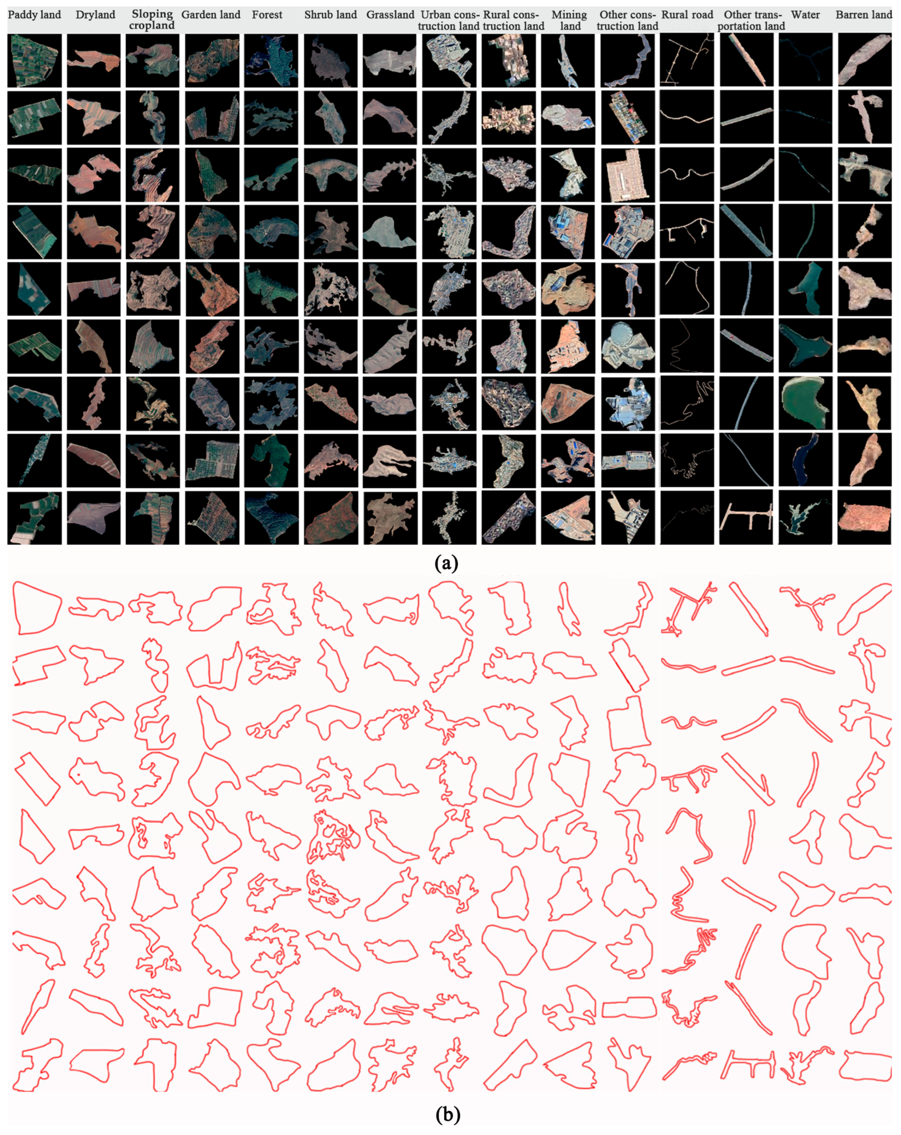
2.1. Description of RVBD
2.2. Classification System
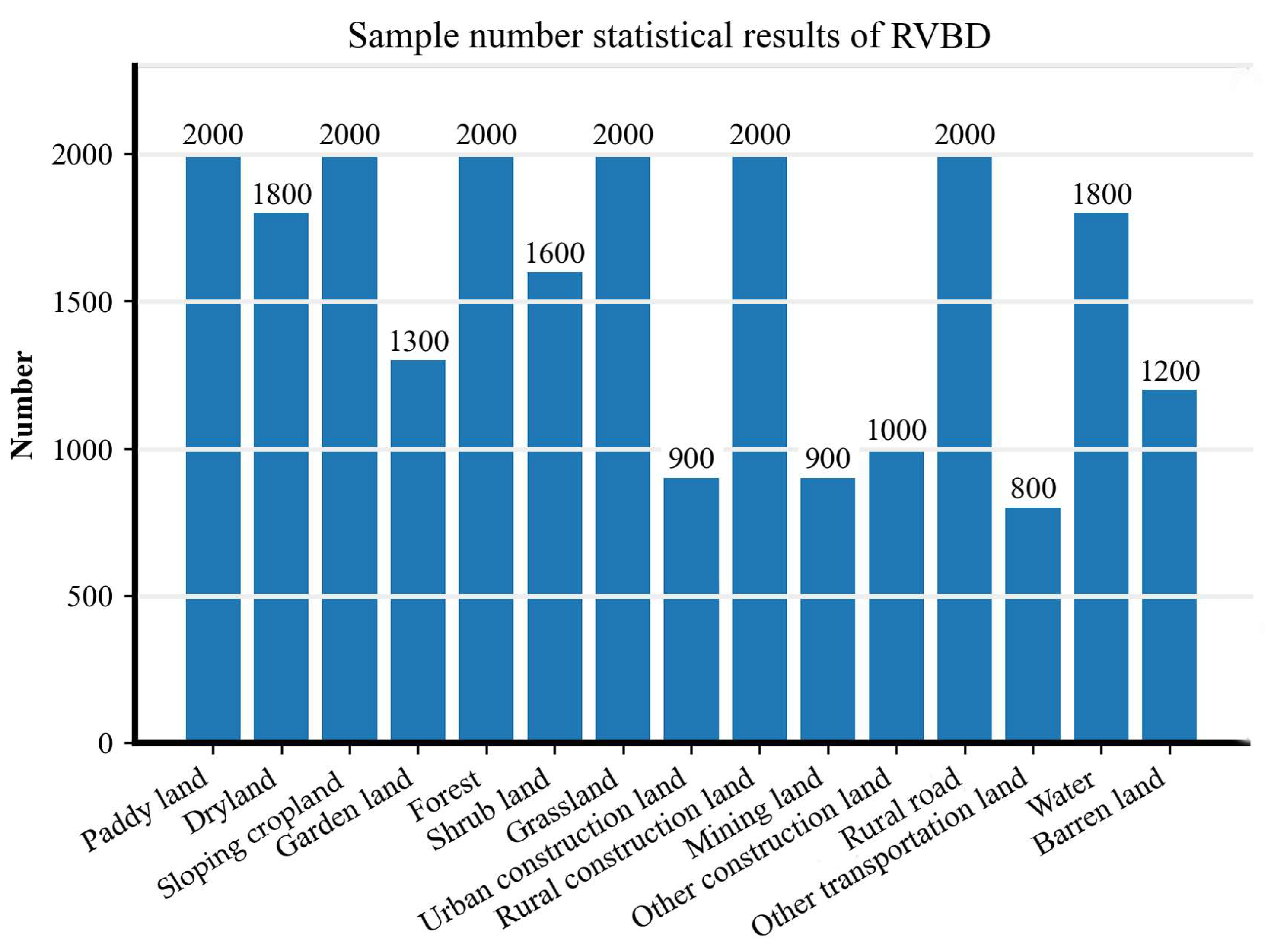
2.3. Dataset Splits
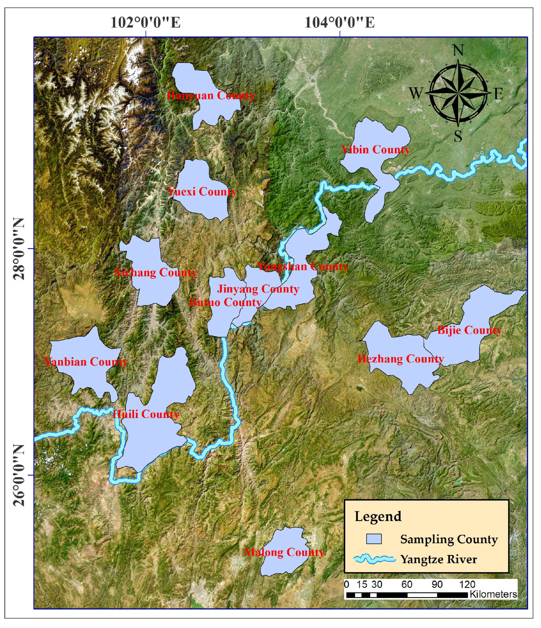
2.4. Study Area
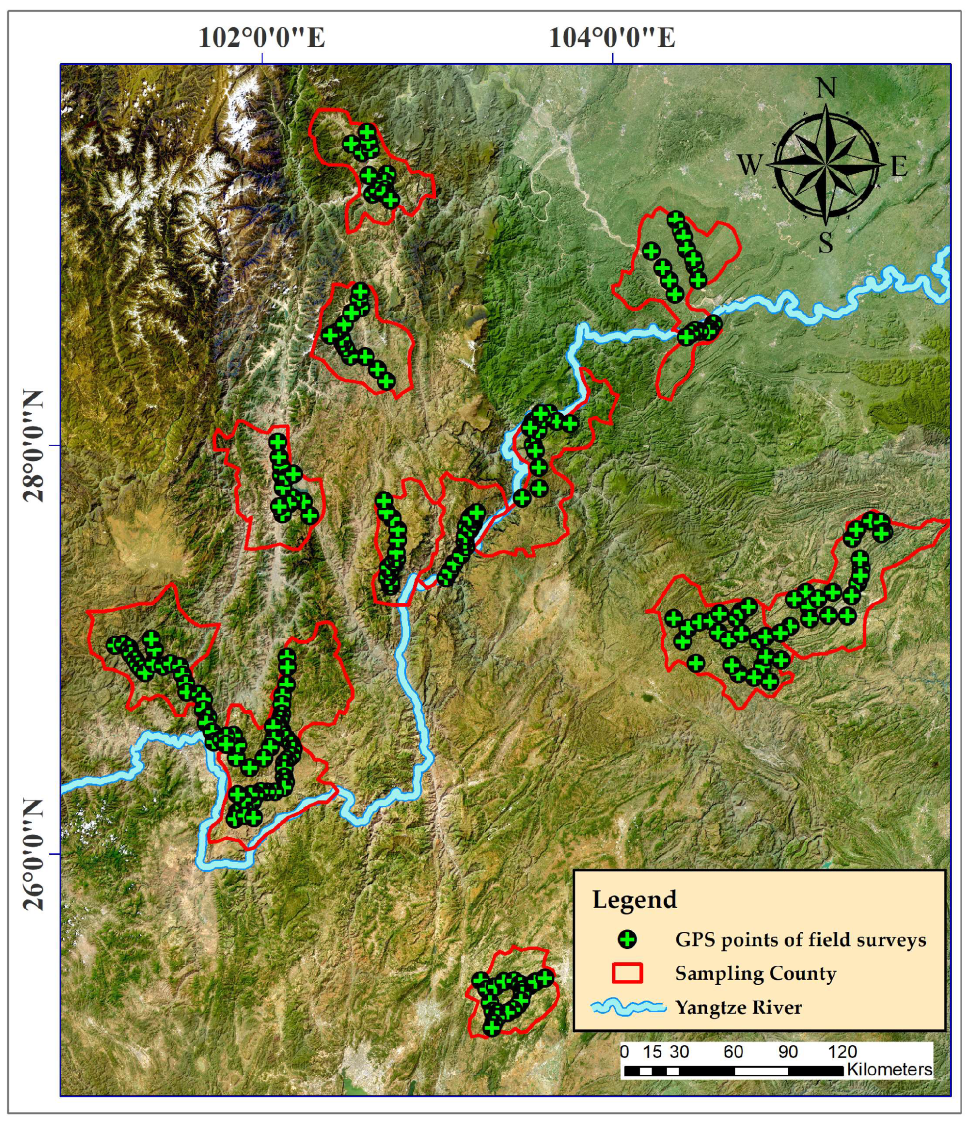
2.5. Field Surveys
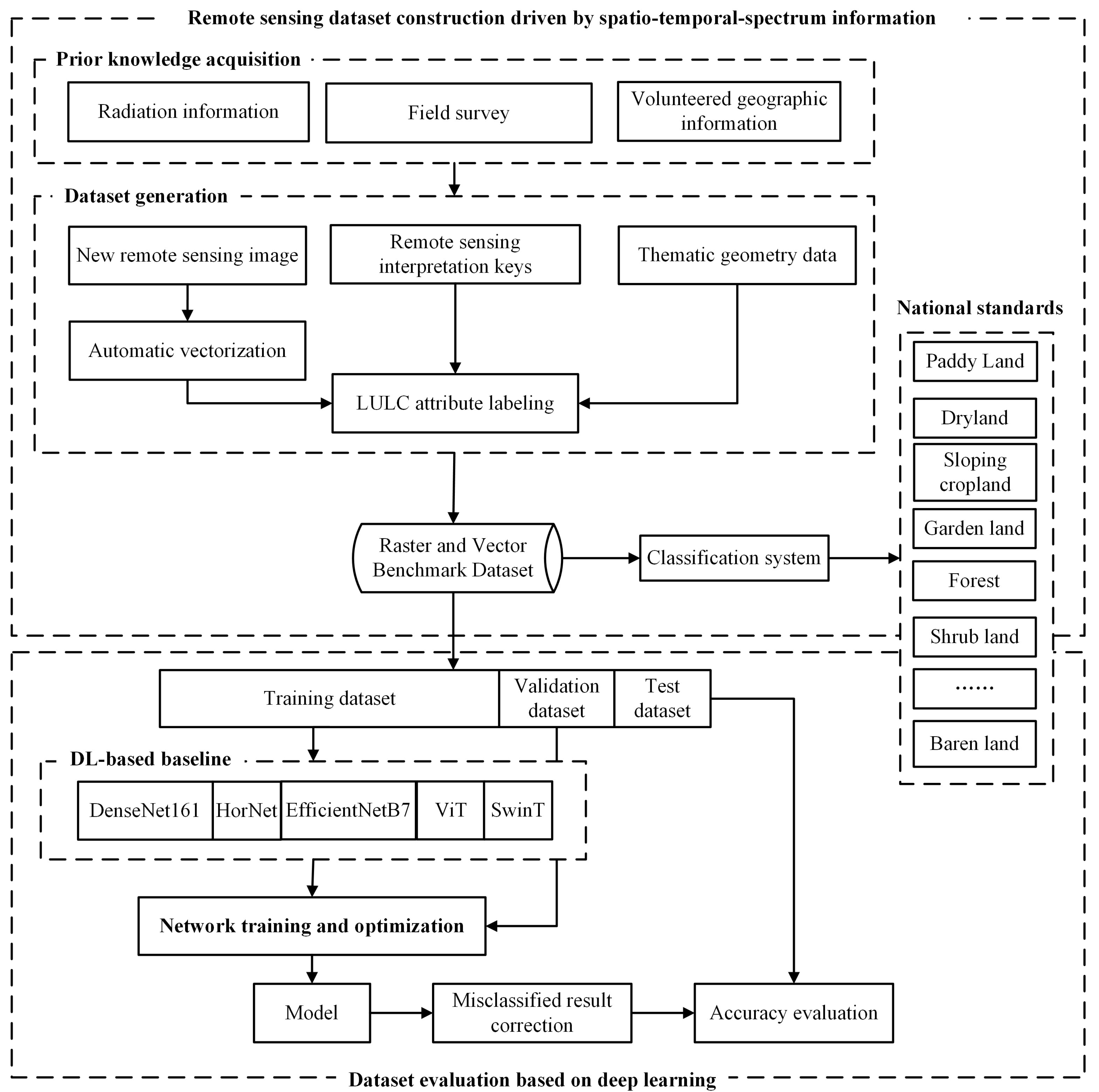
3. Methodology
- (1)
- Remote sensing dataset construction driven by spatio-temporal spectrum information
- (2)
- Dataset evaluation based on DL
3.1. Remote Sensing Dataset Construction Driven by Spatio-Temporal Spectrum Information
- (1)
- Prior knowledge acquisition from spatio-temporal spectral big data
- (2)
- Thematic geometry masking by volunteered geographic information
- (3)
- Automatic vectorization based on multi-resolution segmentation
- (4)
- Attribute labeling and dataset constructing
3.2. Dataset Evaluation Based on DL
3.2.1. DL-Based Baseline
3.2.2. Network Training Strategy
3.2.3. Misclassified Result Correction
- (1)
- Define unreliable classification results. Utilizing the softmax function, the DL-based classification probabilities are generated as output. If the top two highest classification probabilities are approximately equal (i.e., the difference is less than 0.1), they could be considered as unreliable classification results.
- (2)
- Correct the unreliable results by visual interpretation. The manual visual interpretation is employed to update the classification result with the assist of remote sensing interpretation keys.
- (3)
- Verify the results by field surveys. The aforementioned, easily misclassified objects are further verified by field surveys to correct the machine errors generated by DL-based classification and human errors generated by visual interpretation. Especially in regions with terrain or potential hazards, we employ unmanned aerial vehicles (UAVs) to facilitate the manual validation [88].
3.2.4. Evaluation Metrics
4. Experiments and Results
4.1. Experimental Settings
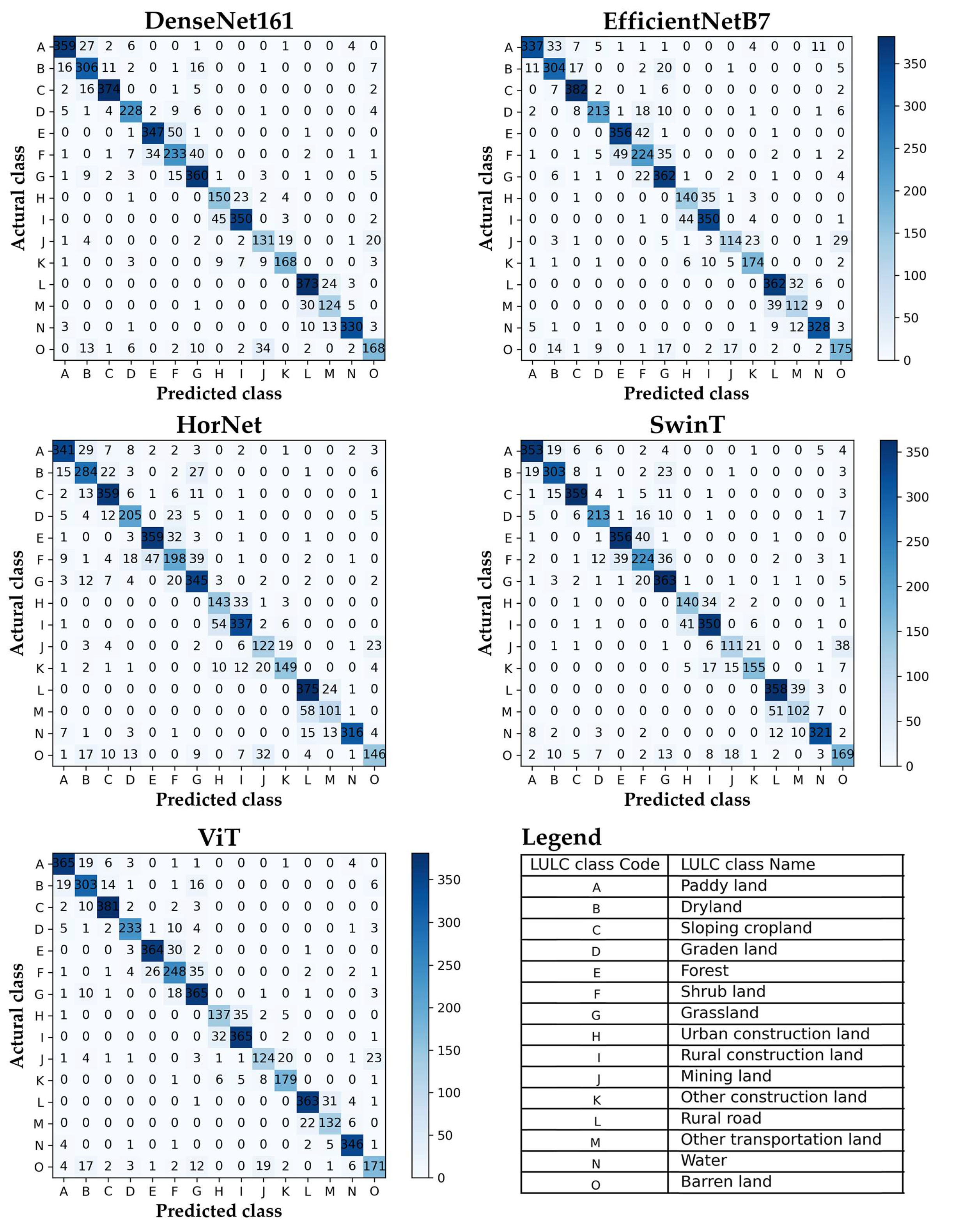
4.2. Results and Analysis
- (1)
- Overall classification accuracy analysis
- (2)
- Class-wise accuracy analysis
4.3. Discussion
- (1)
- The effectiveness and superiority of RVBD
- (2)
- The applicability of RVBD
- (3)
- The classification capacity of DL networks
5. Conclusions
Author Contributions
Funding
Data Availability Statement
Acknowledgments
Conflicts of Interest
References
- Jin, F.; Yang, W.; Fu, J.; Li, Z. Effects of vegetation and climate on the changes of soil erosion in the Loess Plateau of China. Sci. Total Environ. 2021, 773, 145514. [Google Scholar] [CrossRef] [PubMed]
- Vrieling, A. Satellite remote sensing for water erosion assessment: A review. CATENA 2006, 65, 2–18. [Google Scholar] [CrossRef]
- Lamane, H.; Moussadek, R.; Baghdad, B.; Mouhir, L.; Briak, H.; Laghlimi, M.; Zouahri, A. Soil water erosion assessment in Morocco through modeling and fingerprinting applications: A review. Heliyon 2022, 8, e10209. [Google Scholar] [CrossRef]
- Borrelli, P.; Robinson, D.A.; Fleischer, L.R.; Lugato, E.; Ballabio, C.; Alewell, C.; Meusburger, K.; Modugno, S.; Schütt, B.; Ferro, V. An assessment of the global impact of 21st century land use change on soil erosion. Nat. Commun. 2017, 8, 2013. [Google Scholar] [CrossRef] [Green Version]
- Liu, B.; Xie, Y.; Li, Z.; Liang, Y.; Zhang, W.; Fu, S.; Yin, S.; Wei, X.; Zhang, K.; Wang, Z. The assessment of soil loss by water erosion in China. Int. Soil Water Conserv. Res. 2020, 8, 430–439. [Google Scholar] [CrossRef]
- Wuepper, D.; Borrelli, P.; Finger, R. Countries and the global rate of soil erosion. Nat. Sustain. 2020, 3, 51–55. [Google Scholar] [CrossRef]
- Khatami, R.; Mountrakis, G.; Stehman, S.V. A meta-analysis of remote sensing research on supervised pixel-based land-cover image classification processes: General guidelines for practitioners and future research. Remote Sens. Environ. 2016, 177, 89–100. [Google Scholar] [CrossRef] [Green Version]
- Long, C.; Li, X.; Jing, Y.; Shen, H. Bishift Networks for Thick Cloud Removal with Multitemporal Remote Sensing Images. Int. J. Intell. Syst. 2023, 2023, e9953198. [Google Scholar] [CrossRef]
- Dimitrovski, I.; Kitanovski, I.; Kocev, D.; Simidjievski, N. Current trends in deep learning for Earth Observation: An open-source benchmark arena for image classification. ISPRS J. Photogramm. Remote Sens. 2023, 197, 18–35. [Google Scholar] [CrossRef]
- Shen, H.; Zhou, W.; Li, X. A Fast Globally Optimal Seamline Detection Method for High-Resolution Remote Sensing Images. IEEE Geosci. Remote Sens. Lett. 2023, 20, 6003305. [Google Scholar] [CrossRef]
- Tan, Z.; Gao, M.; Li, X.; Jiang, L. A Flexible Reference-Insensitive Spatiotemporal Fusion Model for Remote Sensing Images Using Conditional Generative Adversarial Network. IEEE Trans. Geosci. Remote Sens. 2022, 60, 5601413. [Google Scholar] [CrossRef]
- Sun, X.; Wang, P.; Yan, Z.; Xu, F.; Wang, R.; Diao, W.; Chen, J.; Li, J.; Feng, Y.; Xu, T.; et al. FAIR1M: A benchmark dataset for fine-grained object recognition in high-resolution remote sensing imagery. ISPRS J. Photogramm. Remote Sens. 2022, 184, 116–130. [Google Scholar] [CrossRef]
- Yang, X.; Dong, M.; Wang, Z.; Gao, L.; Zhang, L.; Xue, J.-H. Data-augmented matched subspace detector for hyperspectral subpixel target detection. Pattern Recognit. 2020, 106, 107464. [Google Scholar] [CrossRef]
- Li, K.; Wan, G.; Cheng, G.; Meng, L.; Han, J. Object detection in optical remote sensing images: A survey and a new benchmark. ISPRS J. Photogramm. Remote Sens. 2020, 159, 296–307. [Google Scholar] [CrossRef]
- Deng, J.; Dong, W.; Socher, R.; Li, L.; Li, K.; Li, F. Imagenet: A large-scale hierarchical image database. In Proceedings of the 2009 IEEE Conference on Computer Vision and Pattern Recognition, Miami, FL, USA, 20–25 June 2009; pp. 248–255. [Google Scholar]
- Everingham, M.; Van Gool, L.; Williams, C.K.; Winn, J.; Zisserman, A. The pascal visual object classes (voc) challenge. Int. J. Comput. Vis. 2010, 88, 303–338. [Google Scholar] [CrossRef] [Green Version]
- Benedek, C.; Descombes, X.; Zerubia, J. Building Development Monitoring in Multitemporal Remotely Sensed Image Pairs with Stochastic Birth-Death Dynamics. IEEE Trans. Pattern Anal. Mach. Intell. 2012, 34, 33–50. [Google Scholar] [CrossRef] [Green Version]
- Lin, T.-Y.; Maire, M.; Belongie, S.; Hays, J.; Perona, P.; Ramanan, D.; Dollár, P.; Zitnick, C.L. Microsoft coco: Common objects in context. In Proceedings of the European Conference on Computer Vision, Zurich, Switzerland, 6–12 September 2014; pp. 740–755. [Google Scholar]
- Zhu, H.; Chen, X.; Dai, W.; Fu, K.; Ye, Q.; Jiao, J. Orientation robust object detection in aerial images using deep convolutional neural network. In Proceedings of the 2015 IEEE International Conference on Image Processing (ICIP), Quebec City, QC, Canada, 27–30 September 2015; pp. 3735–3739. [Google Scholar]
- Liu, K.; Mattyus, G. Fast multiclass vehicle detection on aerial images. IEEE Geosci. Remote Sens. Lett. 2015, 12, 1938–1942. [Google Scholar]
- Cheng, G.; Zhou, P.; Han, J. Learning rotation-invariant convolutional neural networks for object detection in VHR optical remote sensing images. IEEE Trans. Geosci. Remote Sens. 2016, 54, 7405–7415. [Google Scholar] [CrossRef]
- Razakarivony, S.; Jurie, F. Vehicle detection in aerial imagery: A small target detection benchmark. J. Vis. Commun. Image Represent. 2016, 34, 187–203. [Google Scholar] [CrossRef] [Green Version]
- Liu, Z.; Wang, H.; Weng, L.; Yang, Y. Ship rotated bounding box space for ship extraction from high-resolution optical satellite images with complex backgrounds. IEEE Geosci. Remote Sens. Lett. 2016, 13, 1074–1078. [Google Scholar] [CrossRef]
- Mundhenk, T.N.; Konjevod, G.; Sakla, W.A.; Boakye, K. A large contextual dataset for classification, detection and counting of cars with deep learning. In Proceedings of the European Conference on Computer Vision, Amsterdam, The Netherlands, 11–14 October 2016; pp. 785–800. [Google Scholar]
- Long, Y.; Gong, Y.; Xiao, Z.; Liu, Q. Accurate object localization in remote sensing images based on convolutional neural networks. IEEE Trans. Geosci. Remote Sens. 2017, 55, 2486–2498. [Google Scholar] [CrossRef]
- Zou, Z.; Shi, Z. Random access memories: A new paradigm for target detection in high resolution aerial remote sensing images. IEEE Trans. Image Process. 2017, 27, 1100–1111. [Google Scholar] [CrossRef]
- Yang, M.Y.; Liao, W.; Li, X.; Rosenhahn, B. Deep learning for vehicle detection in aerial images. In Proceedings of the 2018 25th IEEE International Conference on Image Processing (ICIP), Athens, Greece, 7–10 October 2018; pp. 3079–3083. [Google Scholar]
- Xia, G.; Bai, X.; Ding, J.; Zhu, Z.; Belongie, S.; Luo, J.; Datcu, M.; Pelillo, M.; Zhang, L. DOTA: A large-scale dataset for object detection in aerial images. In Proceedings of the IEEE Conference on Computer Vision and Pattern Recognition, Salt Lake City, UT, USA, 18–23 June 2018; pp. 3974–3983. [Google Scholar]
- Wang, Y.; Bashir, S.M.A.; Khan, M.; Ullah, Q.; Wang, R.; Song, Y.; Guo, Z.; Niu, Y. Remote sensing image super-resolution and object detection: Benchmark and state of the art. Expert Syst. Appl. 2022, 197, 116793. [Google Scholar] [CrossRef]
- Yang, Y.; Newsam, S. Bag-of-visual-words and spatial extensions for land-use classification. In Proceedings of the 18th SIGSPATIAL International Conference on Advances in Geographic Information Systems, San Jose, CA, USA, 2–5 November 2010; pp. 270–279. [Google Scholar]
- Hu, J.; Jiang, T.; Tong, X.; Xia, G.-S.; Zhang, L. A benchmark for scene classification of high spatial resolution remote sensing imagery. In Proceedings of the 2015 IEEE International Geoscience and Remote Sensing Symposium (IGARSS), Milan, Italy, 26–31 July 2015; pp. 5003–5006. [Google Scholar]
- Zou, Q.; Ni, L.; Zhang, T.; Wang, Q. Deep learning based feature selection for remote sensing scene classification. IEEE Geosci. Remote Sens. Lett. 2015, 12, 2321–2325. [Google Scholar] [CrossRef]
- Penatti, O.A.B.; Nogueira, K.; dos Santos, J.A. Do Deep Features Generalize From Everyday Objects to Remote Sensing and Aerial Scenes Domains. In Proceedings of the IEEE Conference on Computer Vision and Pattern Recognition Workshops, Boston, MA, USA, 7–12 June 2015; pp. 44–51. [Google Scholar]
- Zhao, L.; Tang, P.; Huo, L. Feature significance-based multibag-of-visual-words model for remote sensing image scene classification. J. Appl. Remote Sens. 2016, 10, 035004. [Google Scholar] [CrossRef]
- Zhao, B.; Zhong, Y.; Xia, G.-S.; Zhang, L. Dirichlet-derived multiple topic scene classification model for high spatial resolution remote sensing imagery. IEEE Trans. Geosci. Remote Sens. 2015, 54, 2108–2123. [Google Scholar] [CrossRef]
- Xia, G.-S.; Hu, J.; Hu, F.; Shi, B.; Bai, X.; Zhong, Y.; Zhang, L.; Lu, X. AID: A benchmark data set for performance evaluation of aerial scene classification. IEEE Trans. Geosci. Remote Sens. 2017, 55, 3965–3981. [Google Scholar] [CrossRef] [Green Version]
- Jin, P.; Xia, G.-S.; Hu, F.; Lu, Q.; Zhang, L. AID++: An Updated Version of AID on Scene Classification. In Proceedings of the IGARSS 2018—2018 IEEE International Geoscience and Remote Sensing Symposium, Valencia, Spain, 22–27 July 2018; pp. 4721–4724. [Google Scholar]
- Wang, Q.; Liu, S.; Chanussot, J.; Li, X. Scene classification with recurrent attention of VHR remote sensing images. IEEE Trans. Geosci. Remote Sens. 2018, 57, 1155–1167. [Google Scholar] [CrossRef]
- Zhou, W.; Newsam, S.; Li, C.; Shao, Z. PatternNet: A benchmark dataset for performance evaluation of remote sensing image retrieval. ISPRS J. Photogramm. Remote Sens. 2018, 145, 197–209. [Google Scholar] [CrossRef] [Green Version]
- Zhong, Y.; Su, Y.; Wu, S.; Zheng, Z.; Zhao, J.; Ma, A.; Zhu, Q.; Ye, R.; Li, X.; Pellikka, P. Open-source data-driven urban land-use mapping integrating point-line-polygon semantic objects: A case study of Chinese cities. Remote Sens. Environ. 2020, 247, 111838. [Google Scholar] [CrossRef]
- Li, H.; Dou, X.; Tao, C.; Wu, Z.; Chen, J.; Peng, J.; Deng, M.; Zhao, L. RSI-CB: A Large-Scale Remote Sensing Image Classification Benchmark Using Crowdsourced Data. Sensors 2020, 20, 1594. [Google Scholar] [CrossRef] [Green Version]
- Barrena-González, J.; Rodrigo-Comino, J.; Gyasi-Agyei, Y.; Pulido Fernández, M.; Cerdà, A. Applying the RUSLE and ISUM in the Tierra de Barros Vineyards (Extremadura, Spain) to Estimate Soil Mobilisation Rates. Land 2020, 9, 93. [Google Scholar] [CrossRef] [Green Version]
- Helber, P.; Bischke, B.; Dengel, A.; Borth, D. EuroSAT: A Novel Dataset and Deep Learning Benchmark for Land Use and Land Cover Classification. IEEE J. Sel. Top. Appl. Earth Obs. Remote Sens. 2019, 12, 2217–2226. [Google Scholar] [CrossRef] [Green Version]
- Sumbul, G.; Charfuelan, M.; Demir, B.; Markl, V. Bigearthnet: A large-scale benchmark archive for remote sensing image understanding. In Proceedings of the IGARSS 2019-2019 IEEE International Geoscience and Remote Sensing Symposium, Yokohama, Japan, 28 July–2 August 2019; pp. 5901–5904. [Google Scholar]
- Qi, X.; Zhu, P.; Wang, Y.; Zhang, L.; Peng, J.; Wu, M.; Chen, J.; Zhao, X.; Zang, N.; Mathiopoulos, P.T. MLRSNet: A multi-label high spatial resolution remote sensing dataset for semantic scene understanding. ISPRS J. Photogramm. Remote Sens. 2020, 169, 337–350. [Google Scholar] [CrossRef]
- Sumbul, G.; De Wall, A.; Kreuziger, T.; Marcelino, F.; Costa, H.; Benevides, P.; Caetano, M.; Demir, B.; Markl, V. BigEarthNet-MM: A Large-Scale, Multimodal, Multilabel Benchmark Archive for Remote Sensing Image Classification and Retrieval. IEEE Geosci. Remote Sens. Mag. 2021, 9, 174–180. [Google Scholar] [CrossRef]
- Hong, D.; Hu, J.; Yao, J.; Chanussot, J.; Zhu, X.X. Multimodal remote sensing benchmark datasets for land cover classification with a shared and specific feature learning model. ISPRS J. Photogramm. Remote Sens. 2021, 178, 68–80. [Google Scholar] [CrossRef]
- Li, L.; Yao, X.; Cheng, G.; Han, J. AIFS-DATASET for Few-Shot Aerial Image Scene Classification. IEEE Trans. Geosci. Remote Sens. 2022, 60, 5618211. [Google Scholar] [CrossRef]
- Li, Y.; Zhou, Y.; Zhang, Y.; Zhong, L.; Wang, J.; Chen, J. DKDFN: Domain Knowledge-Guided deep collaborative fusion network for multimodal unitemporal remote sensing land cover classification. ISPRS J. Photogramm. Remote Sens. 2022, 186, 170–189. [Google Scholar] [CrossRef]
- Zhang, Z.; Zhang, M.; Gong, J.; Hu, X.; Xiong, H.; Zhou, H.; Cao, Z. LuoJiaAI: A cloud-based artificial intelligence platform for remote sensing image interpretation. Geo-Spat. Inf. Sci. 2023, 1–24. [Google Scholar] [CrossRef]
- Papoutsis, I.; Bountos, N.I.; Zavras, A.; Michail, D.; Tryfonopoulos, C. Benchmarking and scaling of deep learning models for land cover image classification. ISPRS J. Photogramm. Remote Sens. 2023, 195, 250–268. [Google Scholar] [CrossRef]
- Zhang, H.; Zhang, R.; Qi, F.; Liu, X.; Niu, Y.; Fan, Z.; Zhang, Q.; Li, J.; Yuan, L.; Song, Y. The CSLE model based soil erosion prediction: Comparisons of sampling density and extrapolation method at the county level. CATENA 2018, 165, 465–472. [Google Scholar] [CrossRef]
- Dong, Y.; Liang, T.; Yang, C.; Luo, H.; Zhang, Y. Joint Distance Transfer Metric Learning for Remote-Sensing Image Classification. IEEE Geosci. Remote Sens. Lett. 2022, 19, 6506205. [Google Scholar] [CrossRef]
- Yang, C.; Dong, Y.; Du, B.; Zhang, L. Attention-Based Dynamic Alignment and Dynamic Distribution Adaptation for Remote Sensing Cross-Domain Scene Classification. IEEE Trans. Geosci. Remote Sens. 2022, 60, 5634713. [Google Scholar] [CrossRef]
- Hosseiny, B.; Rastiveis, H.; Homayouni, S. An Automated Framework for Plant Detection Based on Deep Simulated Learning from Drone Imagery. Remote Sens. 2020, 12, 3521. [Google Scholar] [CrossRef]
- Northcutt, C.; Jiang, L.; Chuang, I. Confident Learning: Estimating Uncertainty in Dataset Labels. J. Artif. Intell. Res. 2021, 70, 1373–1411. [Google Scholar] [CrossRef]
- Abdollahi, A.; Pradhan, B.; Shukla, N.; Chakraborty, S.; Alamri, A. Deep learning approaches applied to remote sensing datasets for road extraction: A state-of-the-art review. Remote Sens. 2020, 12, 1444. [Google Scholar] [CrossRef]
- Lekki, J.; Deutsch, E.; Sayers, M.; Bosse, K.; Anderson, R.; Tokars, R.; Sawtell, R. Determining remote sensing spatial resolution requirements for the monitoring of harmful algal blooms in the Great Lakes. J. Great Lakes Res. 2019, 45, 434–443. [Google Scholar] [CrossRef]
- Velmurugan, K.; Saravanasankar, S.; Venkumar, P.; Sudhakarapandian, R.; Bona, G.D. Hybrid fuzzy AHP-TOPSIS framework on human error factor analysis: Implications to developing optimal maintenance management system in the SMEs. Sustain. Futur. 2022, 4, 100087. [Google Scholar] [CrossRef]
- Di Bona, G.; Falcone, D.; Forcina, A.; De Carlo, F.; Silvestri, L. Quality Checks Logit Human Reliability (LHR): A New Model to Evaluate Human Error Probability (HEP). Math. Probl. Eng. 2021, 2021, e6653811. [Google Scholar] [CrossRef]
- Liang, X.; Liu, X.; Yao, L. Review–a survey of learning from noisy labels. ECS Sens. Plus 2022, 1, 021401. [Google Scholar] [CrossRef]
- González-Rivero, M.; Beijbom, O.; Rodriguez-Ramirez, A.; Holtrop, T.; González-Marrero, Y.; Ganase, A.; Roelfsema, C.; Phinn, S.; Hoegh-Guldberg, O. Scaling up ecological measurements of coral reefs using semi-automated field image collection and analysis. Remote Sens. 2016, 8, 30. [Google Scholar] [CrossRef]
- Chang, C.-M.; Lee, C.-H.; Igarashi, T. Spatial labeling: Leveraging spatial layout for improving label quality in non-expert image annotation. In Proceedings of the 2021 CHI Conference on Human Factors in Computing Systems, Yokohama, Japan, 8–13 May 2021; pp. 1–12. [Google Scholar]
- Bona, G.D.; Falcone, D.; Forcina, A.; Silvestri, L. Systematic human reliability analysis (SHRA): A new approach to evaluate human error probability (HEP) in a nuclear plant. Int. J. Math. Eng. Manag. Sci. 2021, 6, 345–362. [Google Scholar]
- Gotovac, S.; Zelenika, D.; Marušić, Ž.; Božić-Štulić, D. Visual-based person detection for search-and-rescue with uas: Humans vs. machine learning algorithm. Remote Sens. 2020, 12, 3295. [Google Scholar] [CrossRef]
- Gupta, E.; Das, S.; Rajani, M.B. Archaeological exploration in Srirangapatna and its environ through remote sensing analysis. J. Indian Soc. Remote Sens. 2017, 45, 1057–1063. [Google Scholar] [CrossRef]
- Zhao, Y.; Feng, D.; Yu, L.; See, L.; Fritz, S.; Perger, C.; Gong, P. Assessing and improving the reliability of volunteered land cover reference data. Remote Sens. 2017, 9, 1034. [Google Scholar] [CrossRef] [Green Version]
- Sajjad, H.; Kumar, P. Future challenges and perspective of remote sensing technology. In Applications and Challenges of Geospatial Technology: Potential and Future Trends; Springer: Berlin/Heidelberg, Germany, 2019; pp. 275–277. [Google Scholar]
- Fritz, S.; See, L.; Perger, C.; McCallum, I.; Schill, C.; Schepaschenko, D.; Duerauer, M.; Karner, M.; Dresel, C.; Laso-Bayas, J.-C.; et al. A global dataset of crowdsourced land cover and land use reference data. Sci Data 2017, 4, 170075. [Google Scholar] [CrossRef] [Green Version]
- Wang, X. Information extraction of tourist geological resources based on 3D visualization remote sensing image. Int. Arch. Photogramm. Remote Sens. Spat. Inf. Sci. 2018, XLII-3, 1815–1820. [Google Scholar] [CrossRef] [Green Version]
- Weiers, S.; Bock, M.; Wissen, M.; Rossner, G. Mapping and indicator approaches for the assessment of habitats at different scales using remote sensing and GIS methods. Landsc. Urban Plan. 2004, 67, 43–65. [Google Scholar] [CrossRef]
- Duan, Y.; Li, X.; Zhang, L.; Chen, D.; Ji, H. Mapping national-scale aquaculture ponds based on the Google Earth Engine in the Chinese coastal zone. Aquaculture 2020, 520, 734666. [Google Scholar] [CrossRef]
- Wu, Y.; Zhang, P.; Wu, J.; Li, C. Object-oriented and deep-learning-based high-resolution mapping from large remote sensing imagery. Can. J. Remote Sens. 2021, 47, 396–412. [Google Scholar] [CrossRef]
- Zhao, Y.; Gong, P.; Yu, L.; Hu, L.; Li, X.; Li, C.; Zhang, H.; Zheng, Y.; Wang, J.; Zhao, Y.; et al. Towards a common validation sample set for global land-cover mapping. Int. J. Remote Sens. 2014, 35, 4795–4814. [Google Scholar] [CrossRef]
- Behera, M.D.; Gupta, A.K.; Barik, S.K.; Das, P.; Panda, R.M. Use of satellite remote sensing as a monitoring tool for land and water resources development activities in an Indian tropical site. Environ. Monit. Assess. 2018, 190, 401. [Google Scholar] [CrossRef]
- Zhang, M.; Zhao, X.; Li, W.; Zhang, Y.; Tao, R.; Du, Q. Cross-Scene Joint Classification of Multisource Data With Multilevel Domain Adaption Network. IEEE Trans. Neural Netw. Learn. Syst. 2023, 1–13. [Google Scholar] [CrossRef]
- Wold, S.; Esbensen, K.; Geladi, P. Principal component analysis. Chemom. Intell. Lab. Syst. 1987, 2, 37–52. [Google Scholar] [CrossRef]
- Su, Y.; Zhong, Y.; Zhu, Q.; Zhao, J. Urban scene understanding based on semantic and socioeconomic features: From high-resolution remote sensing imagery to multi-source geographic datasets. ISPRS J. Photogramm. Remote Sens. 2021, 179, 50–65. [Google Scholar] [CrossRef]
- Johnson, B.A.; Iizuka, K. Integrating OpenStreetMap crowdsourced data and Landsat time-series imagery for rapid land use/land cover (LULC) mapping: Case study of the Laguna de Bay area of the Philippines. Appl. Geogr. 2016, 67, 140–149. [Google Scholar] [CrossRef]
- Happ, P.N.; Ferreira, R.S.; Bentes, C.; Costa, G.; Feitosa, R.Q. Multiresolution segmentation: A parallel approach for high resolution image segmentation in multicore architectures. Int. Arch. Photogramm. Remote Sens. Spat. Inf. Sci. 2010, 38, C7. [Google Scholar]
- Liu, Z.; Mao, H.; Wu, C.-Y.; Feichtenhofer, C.; Darrell, T.; Xie, S. A ConvNet for the 2020s. arXiv 2022, arXiv:2201.03545. [Google Scholar] [CrossRef]
- Rao, Y.; Zhao, W.; Tang, Y.; Zhou, J.; Lim, S.N.; Lu, J. Hornet: Efficient high-order spatial interactions with recursive gated convolutions. Adv. Neural Inf. Process. Syst. 2022, 35, 10353–10366. [Google Scholar]
- Huang, G.; Liu, Z.; Van Der Maaten, L.; Weinberger, K.Q. Densely connected convolutional networks. In Proceedings of the IEEE Conference on Computer Vision and Pattern Recognition, Honolulu, HI, USA, 21–26 July 2017; pp. 4700–4708. [Google Scholar]
- Tan, M.; Le, Q. Efficientnet: Rethinking model scaling for convolutional neural networks. In Proceedings of the 36th International Conference on Machine Learning, Long Beach, CA, USA, 9–15 June 2019; pp. 6105–6114. [Google Scholar]
- Dosovitskiy, A.; Beyer, L.; Kolesnikov, A.; Weissenborn, D.; Zhai, X.; Unterthiner, T.; Dehghani, M.; Minderer, M.; Heigold, G.; Gelly, S. An image is worth 16x16 words: Transformers for image recognition at scale. arXiv 2020, arXiv:2010.11929. [Google Scholar]
- Liu, Z.; Lin, Y.; Cao, Y.; Hu, H.; Wei, Y.; Zhang, Z.; Lin, S.; Guo, B. Swin transformer: Hierarchical vision transformer using shifted windows. In Proceedings of the IEEE/CVF International Conference on Computer Vision, Montreal, BC, Canada, 11–17 October 2021; pp. 10012–10022. [Google Scholar]
- He, K.; Zhang, X.; Ren, S.; Sun, J. Deep Residual Learning for Image Recognition. In Proceedings of the IEEE Conference on Computer Vision and Pattern Recognition, Las Vegas, NV, USA, 26 June–1 July 2016; pp. 770–778. [Google Scholar]
- Li, C.; Yao, J.; Li, R.; Zhu, Y.; Yao, H.; Zhang, P.; Wei, D.; Zhao, S.; Li, Y.; Wu, Y. “3S” technologies and application for dynamic monitoring soil and water loss in the Yangtze river bain, China. Int. Arch. Photogramm. Remote Sens. Spat. Inf. Sci. 2020, 43, 1563–1567. [Google Scholar] [CrossRef]
- Loshchilov, I.; Hutter, F. Decoupled weight decay regularization. arXiv 2017, arXiv:1711.05101. [Google Scholar]
- Martins, V.S.; Kaleita, A.L.; Gelder, B.K.; da Silveira, H.L.F.; Abe, C.A. Exploring multiscale object-based convolutional neural network (multi-OCNN) for remote sensing image classification at high spatial resolution. ISPRS J. Photogramm. Remote Sens. 2020, 168, 56–73. [Google Scholar] [CrossRef]
- Ma, L.; Liu, Y.; Zhang, X.; Ye, Y.; Yin, G.; Johnson, B.A. Deep learning in remote sensing applications: A meta-analysis and review. ISPRS J. Photogramm. Remote Sens. 2019, 152, 166–177. [Google Scholar] [CrossRef]
- Li, C.; Fang, S.; Geng, X.; Yuan, Y.; Zheng, X.; Zhang, D.; Li, R.; Sun, W.; Wang, X. Coastal ecosystem service in response to past and future land use and land cover change dynamics in the Yangtze river estuary. J. Clean. Prod. 2023, 385, 135601. [Google Scholar] [CrossRef]
- Xiao, R.; Cao, W.; Liu, Y.; Lu, B. The impacts of landscape patterns spatio-temporal changes on land surface temperature from a multi-scale perspective: A case study of the Yangtze River Delta. Sci. Total Environ. 2022, 821, 153381. [Google Scholar] [CrossRef]
- Zhang, S.; Yang, P.; Xia, J.; Wang, W.; Cai, W.; Chen, N.; Hu, S.; Luo, X.; Li, J.; Zhan, C. Land use/land cover prediction and analysis of the middle reaches of the Yangtze River under different scenarios. Sci. Total Environ. 2022, 833, 155238. [Google Scholar] [CrossRef]
- Zhang, J.; Li, W.; Zhai, L. Understanding geographical conditions monitoring: A perspective from China. Int. J. Digit. Earth 2015, 8, 38–57. [Google Scholar] [CrossRef]
- Liu, Y.; Ding, L.; Chen, C.; Liu, Y. Similarity-Based Unsupervised Deep Transfer Learning for Remote Sensing Image Retrieval. IEEE Trans. Geosci. Remote Sens. 2020, 58, 7872–7889. [Google Scholar] [CrossRef]


| Level Ⅰ | Level Ⅱ | Remote Sensing Interpretation Key | |
|---|---|---|---|
| Name | Name | Remote Sensing Image | Photo |
| Cultivated land | Paddy land | 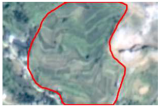 |  |
| Dry land | 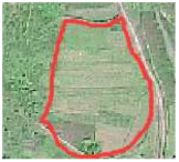 |  | |
| Sloping cropland | 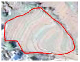 |  | |
| Garden land | Garden land |  | 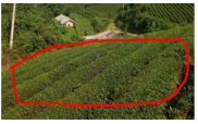 |
| Forest | Forest | 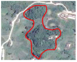 |  |
| Shrub land |  |  | |
| Grassland | Grassland |  |  |
| Construction land | Urban construction land |  |  |
| Rural construction land | 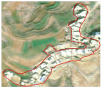 |  | |
| Mining land | 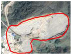 | 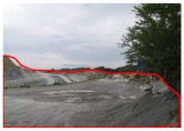 | |
| Other construction land | 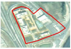 | 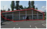 | |
| Transportation land | Other transportation land | 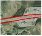 | 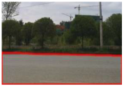 |
| Rural road | 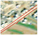 | 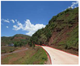 | |
| Water | Water |  | 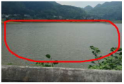 |
| Other land | Barren land | 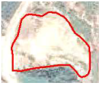 | 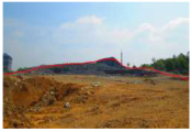 |
| LULC Category | Training Set | Validation Set | Test Set |
|---|---|---|---|
| Paddy land | 1200 | 400 | 400 |
| Dry land | 1080 | 360 | 360 |
| Sloping cropland | 1200 | 400 | 400 |
| Garden | 780 | 260 | 260 |
| Forest | 1200 | 400 | 400 |
| Shrub land | 960 | 320 | 320 |
| Grassland | 1200 | 400 | 400 |
| Urban construction land | 540 | 180 | 180 |
| Rural construction land | 1200 | 400 | 400 |
| Mining land | 540 | 180 | 180 |
| Other construction land | 600 | 200 | 200 |
| Other transportation land | 1200 | 400 | 400 |
| Rural road | 480 | 160 | 160 |
| Water | 1080 | 360 | 360 |
| Barren land | 720 | 240 | 240 |
| Total number | 13,980 | 4660 | 4660 |
| Network Name | Overall Accuracy | Kappa |
|---|---|---|
| DenseNet161 [83] | 0.86 | 0.85 |
| EfficientNetB7 [84] | 0.84 | 0.83 |
| HorNet [82] | 0.81 | 0.80 |
| SwinT [86] | 0.83 | 0.82 |
| ViT [85] | 0.87 | 0.86 |
| Network Name | DenseNet161 [83] | EfficientNetB7 [84] | HorNet [82] | SwinT [86] | ViT [85] | |
|---|---|---|---|---|---|---|
| LULC Class | ||||||
| Paddy land | 0.92 | 0.94 | 0.88 | 0.90 | 0.91 | |
| Dry land | 0.81 | 0.82 | 0.78 | 0.86 | 0.83 | |
| Sloping cropland | 0.95 | 0.91 | 0.84 | 0.92 | 0.93 | |
| Garden | 0.88 | 0.90 | 0.78 | 0.86 | 0.93 | |
| Forest | 0.91 | 0.87 | 0.88 | 0.89 | 0.93 | |
| Shrub land | 0.75 | 0.72 | 0.70 | 0.72 | 0.79 | |
| Grassland | 0.81 | 0.79 | 0.78 | 0.79 | 0.83 | |
| Urban construction land | 0.73 | 0.73 | 0.68 | 0.75 | 0.78 | |
| Rural construction land | 0.91 | 0.87 | 0.84 | 0.84 | 0.90 | |
| Mining land | 0.72 | 0.81 | 0.68 | 0.75 | 0.81 | |
| Other construction land | 0.86 | 0.83 | 0.84 | 0.83 | 0.86 | |
| Other transportation land | 0.89 | 0.87 | 0.82 | 0.84 | 0.93 | |
| Rural road | 0.77 | 0.72 | 0.73 | 0.67 | 0.78 | |
| Water | 0.95 | 0.91 | 0.98 | 0.93 | 0.94 | |
| Barren land | 0.78 | 0.76 | 0.75 | 0.70 | 0.81 | |
| Mean Values | 0.84 | 0.83 | 0.80 | 0.82 | 0.86 | |
| Network Name | DenseNet161 [83] | EfficientNetB7 [84] | HorNet [82] | SwinT [86] | ViT [85] | |
|---|---|---|---|---|---|---|
| LULC Class | ||||||
| Paddy land | 0.90 | 0.84 | 0.85 | 0.88 | 0.91 | |
| Dry land | 0.85 | 0.84 | 0.79 | 0.84 | 0.84 | |
| Sloping cropland | 0.93 | 0.95 | 0.90 | 0.90 | 0.95 | |
| Garden | 0.88 | 0.82 | 0.79 | 0.82 | 0.90 | |
| Forest | 0.87 | 0.89 | 0.90 | 0.89 | 0.91 | |
| Shrub land | 0.73 | 0.70 | 0.62 | 0.70 | 0.77 | |
| Grassland | 0.90 | 0.90 | 0.86 | 0.91 | 0.91 | |
| Urban construction land | 0.83 | 0.78 | 0.79 | 0.78 | 0.76 | |
| Rural construction land | 0.87 | 0.87 | 0.84 | 0.87 | 0.91 | |
| Mining land | 0.73 | 0.63 | 0.68 | 0.62 | 0.69 | |
| Other construction land | 0.84 | 0.87 | 0.74 | 0.77 | 0.89 | |
| Other transportation land | 0.93 | 0.90 | 0.94 | 0.89 | 0.91 | |
| Rural road | 0.77 | 0.70 | 0.63 | 0.64 | 0.82 | |
| Water | 0.92 | 0.91 | 0.88 | 0.89 | 0.96 | |
| Barren land | 0.70 | 0.73 | 0.61 | 0.70 | 0.71 | |
| Mean Values | 0.84 | 0.82 | 0.79 | 0.81 | 0.86 | |
| Network Name | DenseNet161 [83] | EfficientNetB7 [84] | HorNet [82] | SwinT [86] | ViT [85] | |
|---|---|---|---|---|---|---|
| LULC Class | ||||||
| Paddy land | 0.91 | 0.89 | 0.87 | 0.89 | 0.91 | |
| Dry land | 0.83 | 0.83 | 0.78 | 0.85 | 0.84 | |
| Sloping cropland | 0.94 | 0.93 | 0.87 | 0.91 | 0.94 | |
| Garden | 0.88 | 0.86 | 0.78 | 0.84 | 0.91 | |
| Forest | 0.89 | 0.88 | 0.89 | 0.89 | 0.92 | |
| Shrub land | 0.74 | 0.71 | 0.66 | 0.71 | 0.78 | |
| Grassland | 0.86 | 0.84 | 0.82 | 0.84 | 0.87 | |
| Urban construction land | 0.78 | 0.75 | 0.73 | 0.76 | 0.77 | |
| Rural construction land | 0.89 | 0.87 | 0.84 | 0.86 | 0.91 | |
| Mining land | 0.73 | 0.71 | 0.68 | 0.68 | 0.74 | |
| Other construction land | 0.85 | 0.85 | 0.79 | 0.80 | 0.88 | |
| Other transportation land | 0.91 | 0.89 | 0.87 | 0.87 | 0.92 | |
| Rural road | 0.77 | 0.71 | 0.68 | 0.65 | 0.80 | |
| Water | 0.93 | 0.91 | 0.93 | 0.91 | 0.95 | |
| Barren land | 0.74 | 0.75 | 0.67 | 0.70 | 0.76 | |
| Mean Values | 0.84 | 0.83 | 0.79 | 0.81 | 0.86 | |
Disclaimer/Publisher’s Note: The statements, opinions and data contained in all publications are solely those of the individual author(s) and contributor(s) and not of MDPI and/or the editor(s). MDPI and/or the editor(s) disclaim responsibility for any injury to people or property resulting from any ideas, methods, instructions or products referred to in the content. |
© 2023 by the authors. Licensee MDPI, Basel, Switzerland. This article is an open access article distributed under the terms and conditions of the Creative Commons Attribution (CC BY) license (https://creativecommons.org/licenses/by/4.0/).
Share and Cite
Zhang, P.; Wu, Y.; Li, C.; Li, R.; Yao, H.; Zhang, Y.; Zhang, G.; Li, D. National-Standards- and Deep-Learning-Oriented Raster and Vector Benchmark Dataset (RVBD) for Land-Use/Land-Cover Mapping in the Yangtze River Basin. Remote Sens. 2023, 15, 3907. https://doi.org/10.3390/rs15153907
Zhang P, Wu Y, Li C, Li R, Yao H, Zhang Y, Zhang G, Li D. National-Standards- and Deep-Learning-Oriented Raster and Vector Benchmark Dataset (RVBD) for Land-Use/Land-Cover Mapping in the Yangtze River Basin. Remote Sensing. 2023; 15(15):3907. https://doi.org/10.3390/rs15153907
Chicago/Turabian StyleZhang, Pengfei, Yijin Wu, Chang Li, Renhua Li, He Yao, Yong Zhang, Genlin Zhang, and Dehua Li. 2023. "National-Standards- and Deep-Learning-Oriented Raster and Vector Benchmark Dataset (RVBD) for Land-Use/Land-Cover Mapping in the Yangtze River Basin" Remote Sensing 15, no. 15: 3907. https://doi.org/10.3390/rs15153907
APA StyleZhang, P., Wu, Y., Li, C., Li, R., Yao, H., Zhang, Y., Zhang, G., & Li, D. (2023). National-Standards- and Deep-Learning-Oriented Raster and Vector Benchmark Dataset (RVBD) for Land-Use/Land-Cover Mapping in the Yangtze River Basin. Remote Sensing, 15(15), 3907. https://doi.org/10.3390/rs15153907