
Smartphone Structure-from-Motion Photogrammetry from a Boat for Coastal Cliff Face Monitoring Compared with Pléiades Tri-Stereoscopic Imagery and Unmanned Aerial System Imagery

 ,
,  , ,
, ,  ,
,  ,
,
Abstract

1. Introduction
1.1. Context
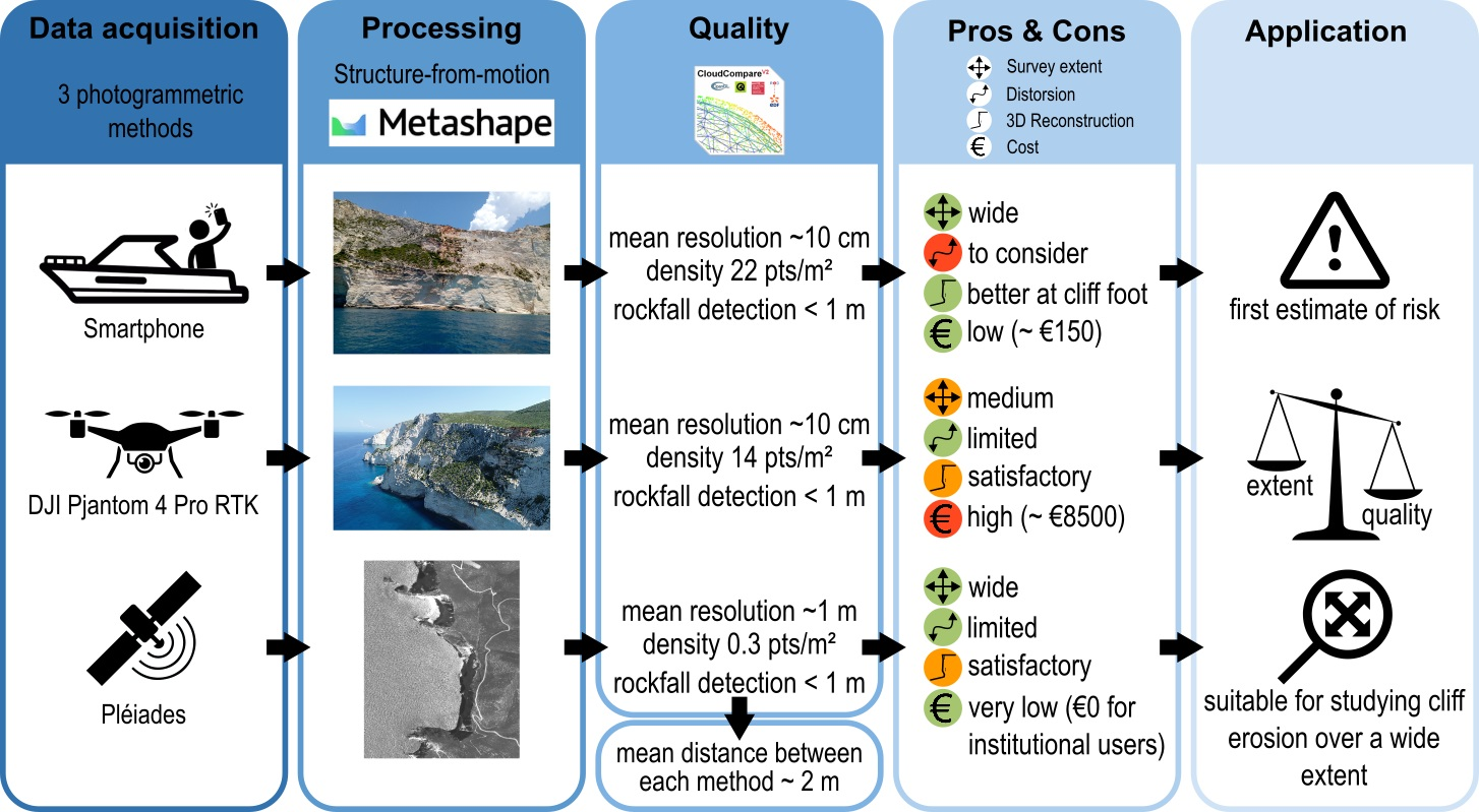
1.2. Monitoring Methods
2. Material and Methods
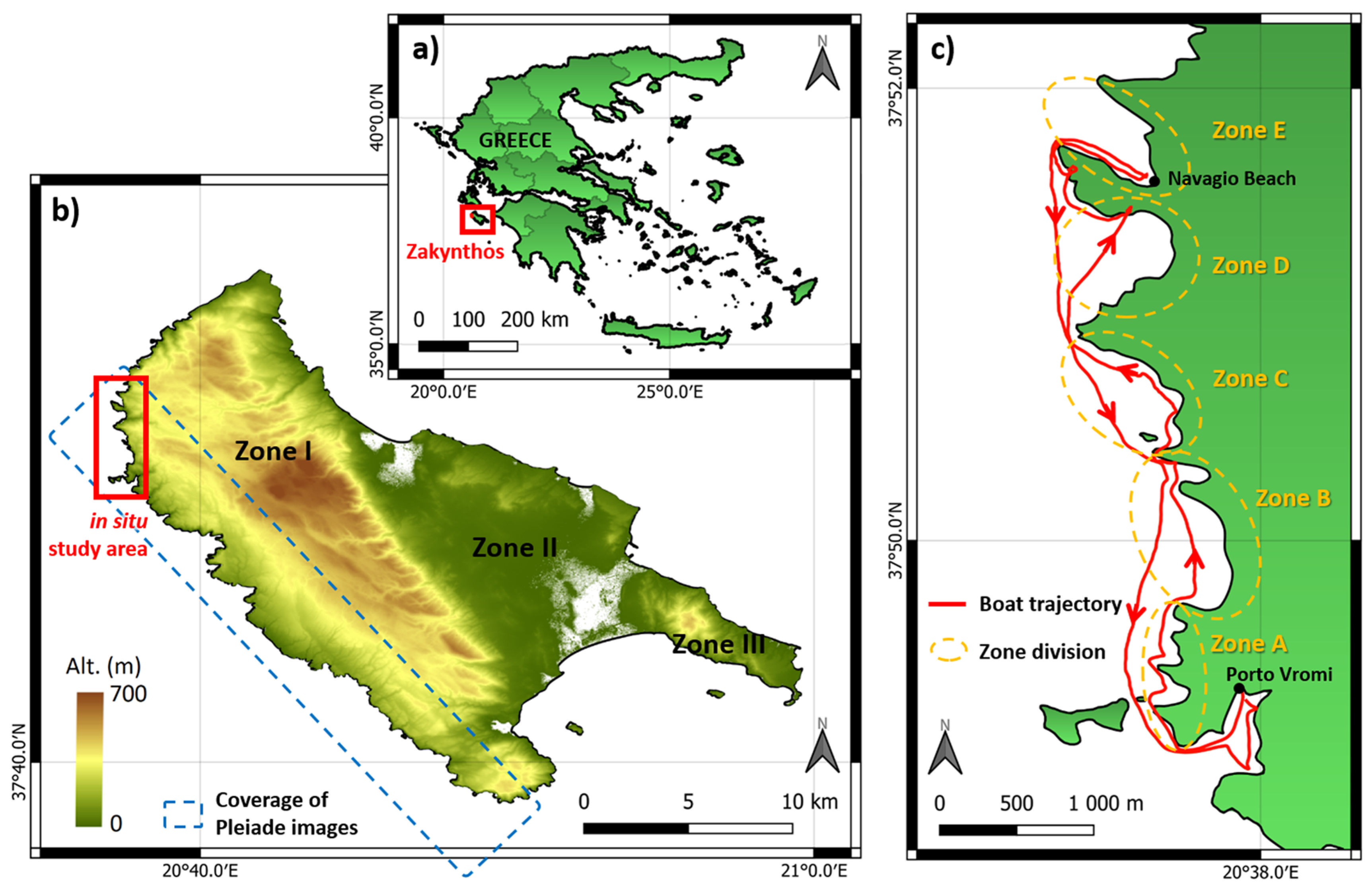
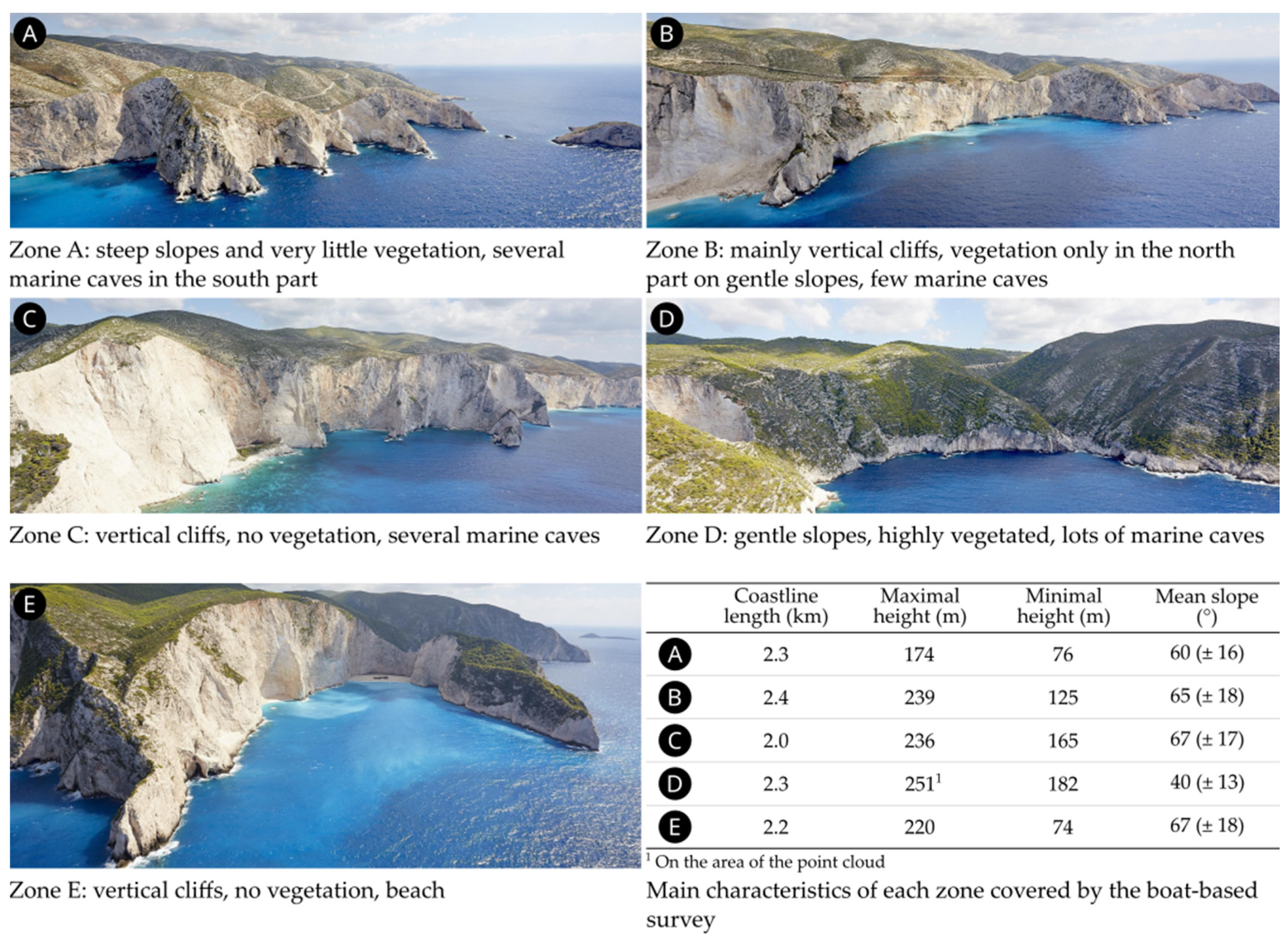
2.1. Study Area
- Visible mass movements;
- An exposure compatible with the satellite acquisition (not too many parts exposed to the north);
- A straight-lined shape;
- A cliff top that was easily accessible so that the UAS could have a departure point from the cliff top;
- Variations in the cliff profile, with various slopes and rock covers.
2.2. Boat-Based Smartphone SfM Photogrammetry
2.3. Pléiades Satellite Imagery
2.4. UAS SfM Photogrammetry
2.5. Inter-Comparison Method
3. Results
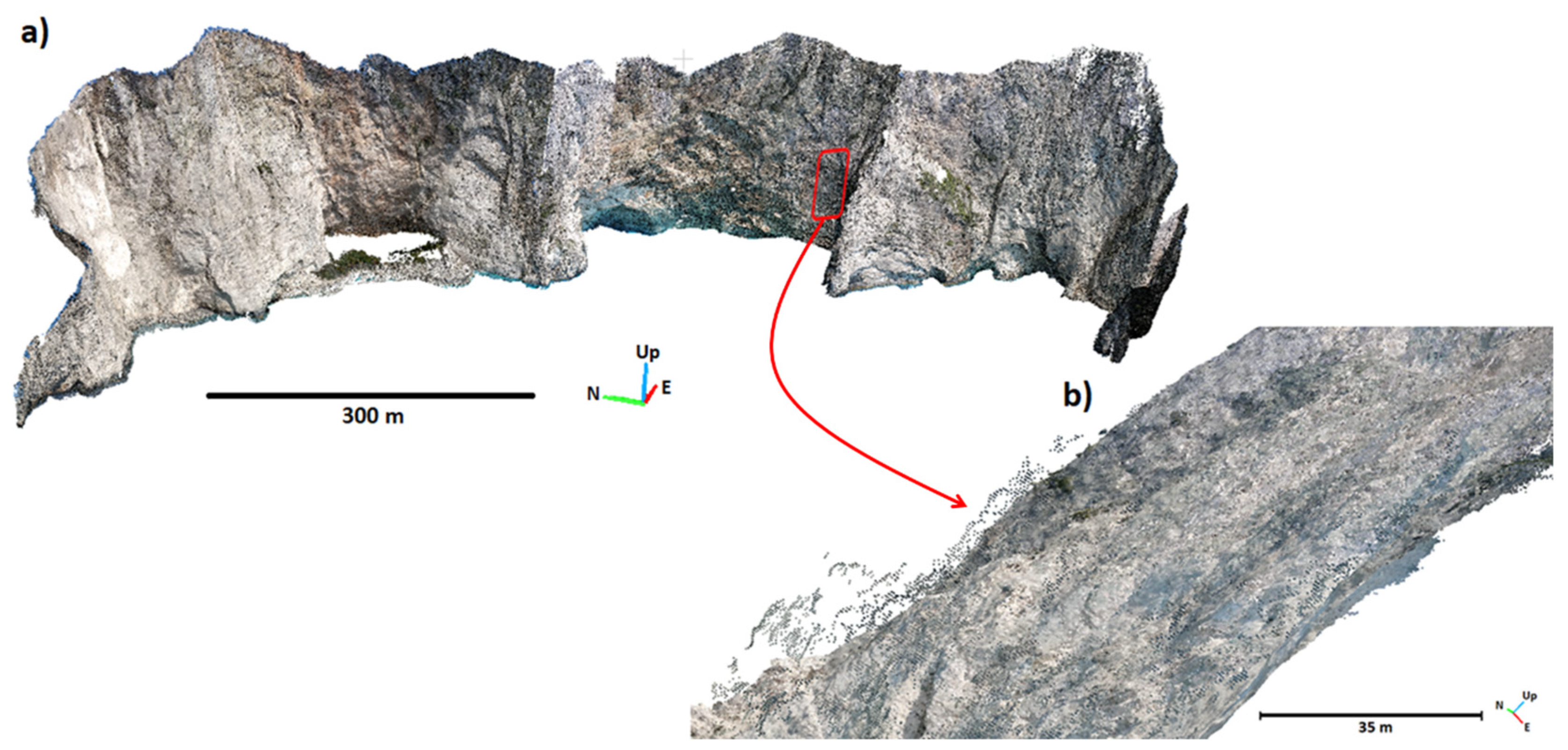
3.1. Smartphone SfM Photogrammetry from the Boat
3.2. Pléiades Satellite Stereorestitution
3.3. UAS SfM Photogrammetry
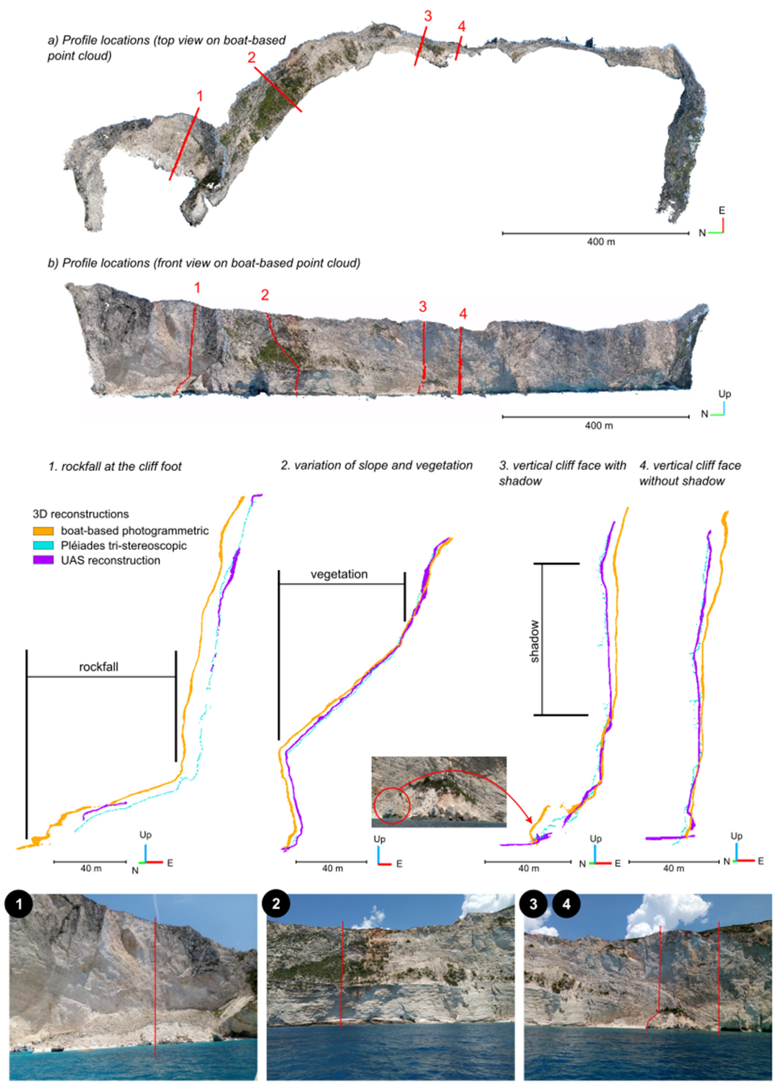
3.4. Inter-Comparison
4. Discussion
4.1. Advantages and Drawbacks of Each Method
4.2. Prospects
5. Conclusions
Author Contributions
Funding
Data Availability Statement
Acknowledgments
Conflicts of Interest
Appendix A

Appendix B

References
- Letortu, P.; Le Dantec, N.; Augereau, E.; Costa, S.; Maquaire, O.; Davidson, R.; Fauchard, C.; Antoine, R.; Flahaut, R.; Guirriec, Y.; et al. Experimental field study on the fatigue and failure mechanisms of coastal chalk cliffs: Implementation of a multi-parameter monitoring system (Sainte-Marguerite-sur-Mer, France). Geomorphology 2022, 408, 108211. [Google Scholar] [CrossRef]
- Cooley, S.R.; Schoeman, D.S.; Bopp, L.; Boyd, P.; Donner, S.; Ito, S.-I.; Kiessling, W.; Martinetto, P.; Ojea, E.; Racault, M.-F.; et al. 2022: Oceans and Coastal Ecosystems and Their Services. In Climate Change 2022: Impacts, Adaptation and Vulnerability. Contribution of Working Group II to the Sixth Assessment Report of the Intergovernmental Panel on Climate Change; Pörtner, H.-O., Roberts, D.C., Tignor, M., Poloczanska, K., Mintenbeck, K., Alegría, A., Craig, M., Langsdorf, S., Löschke, S., Möller, V., et al., Eds.; Cambridge University Press: Cambridge, UK, 2022; pp. 379–550. [Google Scholar]
- Bondarenko, M.; Kerr, D.; Sorichetta, A.; Tatem, A. Census/Projection-Disaggregated Gridded Population Datasets for 189 Countries in 2020 Using Built-Settlement Growth Model (BSGM) Outputs; University of Southampton: Southampton, UK, 2020. [Google Scholar]
- Reimann, L.; Vafeidis, A.T.; Honsel, L.E. Population development as a driver of coastal risk: Current trends and future pathways. Camb. Prism. Coast. Futur. 2023, 1, e14. [Google Scholar] [CrossRef]
- Young, A.P.; Carilli, J.E. Global distribution of coastal cliffs. Earth Surf. Process. Landforms 2019, 44, 1309–1316. [Google Scholar] [CrossRef]
- Costa, S. “Dynamique Littorale et Risques Naturels”: L’impact Des Aménagements, Des Variations Du Niveau Marin et Des Modifications Climatiques Entre La Baie de Seine et La Baie de Somme (Haute-Normandie, Picardie; France). Ph.D. Thesis, University of Paris, Paris, France, 1997. [Google Scholar]
- Zviely, D.; Klein, M. Coastal cliff retreat rates at Beit-Yannay, Israel, in the 20th century. Earth Surf. Process. Landforms 2004, 29, 175–184. [Google Scholar] [CrossRef]
- Foyle, A.M.; Naber, M.D. Decade-scale coastal bluff retreat from LiDAR data: Lake Erie coast of NW Pennsylvania, USA. Environ. Earth Sci. 2012, 66, 1999–2012. [Google Scholar] [CrossRef]
- Letortu, P.; Taouki, R.; Jaud, M.; Costa, S.; Maquaire, O.; Delacourt, C. Three-dimensional (3D) reconstructions of the coastal cliff face in Normandy (France) based on oblique Pléiades imagery: Assessment of Ames Stereo Pipeline® (ASP®) and MicMac® processing chains. Int. J. Remote. Sens. 2021, 42, 4558–4578. [Google Scholar] [CrossRef]
- Terefenko, P.; Paprotny, D.; Giza, A.; Morales-Nápoles, O.; Kubicki, A.; Walczakiewicz, S. Monitoring Cliff Erosion with LiDAR Surveys and Bayesian Network-based Data Analysis. Remote Sens. 2019, 11, 843. [Google Scholar] [CrossRef]
- Terefenko, P.; Wziątek, D.Z.; Dalyot, S.; Boski, T.; Lima-Filho, F.P. A High-Precision LiDAR-Based Method for Surveying and Classifying Coastal Notches. ISPRS Int. J. Geo-Inf. 2018, 7, 295. [Google Scholar] [CrossRef]
- Swirad, Z.M.; Young, A.P. Automating coastal cliff erosion measurements from large-area LiDAR datasets in California, USA. Geomorphology 2021, 389, 107799. [Google Scholar] [CrossRef]
- Young, A.P.; Olsen, M.J.; Driscoll, N.; Flick, R.; Gutierrez, R.; Guza, R.; Johnstone, E.; Kuester, F. Comparison of Airborne and Terrestrial Lidar Estimates of Seacliff Erosion in Southern California. Photogramm. Eng. Remote. Sens. 2010, 76, 421–427. [Google Scholar] [CrossRef]
- Vassilakis, E.; Konsolaki, A.; Petrakis, S.; Kotsi, E.; Fillis, C.; Triantaphyllou, M.; Antonarakou, A.; Lekkas, E. Combination of Close-Range Remote Sensing Data (TLS and UAS) and Techniques for Structural Measurements across the Deformation Zone of the Ionian Thrust in Zakynthos Isl. In Proceedings of the 16th International Congress of the Geological Society of Greece, Patras, Greece, 17–19 October 2022. [Google Scholar]
- Diakakis, M.; Vassilakis, E.; Mavroulis, S.; Konsolaki, A.; Kaviris, G.; Kotsi, E.; Kapetanidis, V.; Sakkas, V.; Alexopoulos, J.D.; Lekkas, E.; et al. An Integrated UAS and TLS Approach for Monitoring Coastal Scarps and Mass Movement Phenomena. The Case of Ionian Islands. In Proceedings of the EGU General Assembly 2022, Vienna, Austria, 23–27 May 2022. [Google Scholar]
- Gallo, I.G.; Martínez-Corbella, M.; Sarro, R.; Iovine, G.; López-Vinielles, J.; Hérnandez, M.; Robustelli, G.; Mateos, R.M.; García-Davalillo, J.C. An Integration of UAV-Based Photogrammetry and 3D Modelling for Rockfall Hazard Assessment: The Cárcavos Case in 2018 (Spain). Remote. Sens. 2021, 13, 3450. [Google Scholar] [CrossRef]
- Karantanellis, E.; Marinos, V.; Vassilakis, E.; Christaras, B. Object-Based Analysis Using Unmanned Aerial Vehicles (UAVs) for Site-Specific Landslide Assessment. Remote. Sens. 2020, 12, 1711. [Google Scholar] [CrossRef]
- Brush, J.A.; Pavlis, T.L.; Hurtado, J.M.; Mason, K.A.; Knott, J.R.; Williams, K.E. Evaluation of field methods for 3-D mapping and 3-D visualization of complex metamorphic structure using multiview stereo terrain models from ground-based photography. Geosphere 2018, 15, 188–221. [Google Scholar] [CrossRef]
- Hansman, R.J.; Ring, U. Workflow: From photo-based 3-D reconstruction of remotely piloted aircraft images to a 3-D geological model. Geosphere 2019, 15, 1393–1408. [Google Scholar] [CrossRef]
- Vanneschi, C.; Di Camillo, M.; Aiello, E.; Bonciani, F.; Salvini, R. SfM-MVS Photogrammetry for Rockfall Analysis and Hazard Assessment Along the Ancient Roman Via Flaminia Road at the Furlo Gorge (Italy). ISPRS Int. J. Geo-Inf. 2019, 8, 325. [Google Scholar] [CrossRef]
- Gonçalves, G.; Gonçalves, D.; Gómez-Gutiérrez, A.; Andriolo, U.; Pérez-Alvárez, J.A. 3D Reconstruction of Coastal Cliffs from Fixed-Wing and Multi-Rotor UAS: Impact of SfM-MVS Processing Parameters, Image Redundancy and Acquisition Geometry. Remote. Sens. 2021, 13, 1222. [Google Scholar] [CrossRef]
- Genchi, S.A.; Vitale, A.J.; Perillo, G.M.E.; Delrieux, C.A. Structure-from-Motion Approach for Characterization of Bioerosion Patterns Using UAV Imagery. Sensors 2015, 15, 3593–3609. [Google Scholar] [CrossRef]
- Jaud, M.; Bertin, S.; Beauverger, M.; Augereau, E.; Delacourt, C. RTK GNSS-Assisted Terrestrial SfM Photogrammetry without GCP: Application to Coastal Morphodynamics Monitoring. Remote. Sens. 2020, 12, 1889. [Google Scholar] [CrossRef]
- Tavani, S.; Pignalosa, A.; Corradetti, A.; Mercuri, M.; Smeraglia, L.; Riccardi, U.; Seers, T.; Pavlis, T.; Billi, A. Photogrammetric 3D Model via Smartphone GNSS Sensor: Workflow, Error Estimate, and Best Practices. Remote. Sens. 2020, 12, 3616. [Google Scholar] [CrossRef]
- Tavani, S.; Granado, P.; Riccardi, U.; Seers, T.; Corradetti, A. Terrestrial SfM-MVS photogrammetry from smartphone sensors. Geomorphology 2020, 367, 107318. [Google Scholar] [CrossRef]
- Micheletti, N.; Chandler, J.H.; Lane, S.N. Investigating the geomorphological potential of freely available and accessible structure-from-motion photogrammetry using a smartphone. Earth Surf. Process. Landforms 2015, 40, 473–486. [Google Scholar] [CrossRef]
- Sofia, G.; Masin, R.; Tarolli, P. Prospects for crowdsourced information on the geomorphic ‘engineering’ by the invasive Coypu (Myocastor coypus). Earth Surf. Process. Landforms 2017, 42, 365–377. [Google Scholar] [CrossRef]
- Corradetti, A.; Seers, T.; Mercuri, M.; Calligaris, C.; Busetti, A.; Zini, L. Benchmarking Different SfM-MVS Photogrammetric and iOS LiDAR Acquisition Methods for the Digital Preservation of a Short-Lived Excavation: A Case Study from an Area of Sinkhole Related Subsidence. Remote. Sens. 2022, 14, 5187. [Google Scholar] [CrossRef]
- Fang, K.; An, P.; Tang, H.; Tu, J.; Jia, S.; Miao, M.; Dong, A. Application of a multi-smartphone measurement system in slope model tests. Eng. Geol. 2021, 295, 106424. [Google Scholar] [CrossRef]
- Luetzenburg, G.; Kroon, A.; Bjørk, A.A. Evaluation of the Apple iPhone 12 Pro LiDAR for an Application in Geosciences. Sci. Rep. 2021, 11, 22221. [Google Scholar] [CrossRef] [PubMed]
- Letortu, P.; Jaud, M.; Grandjean, P.; Ammann, J.; Costa, S.; Maquaire, O.; Davidson, R.; Le Dantec, N.; Delacourt, C. Examining high-resolution survey methods for monitoring cliff erosion at an operational scale. GIScience Remote. Sens. 2018, 55, 457–476. [Google Scholar] [CrossRef]
- Ružić, I.; Marović, I.; Benac, C.; Ilić, S. Coastal cliff geometry derived from structure-from-motion photogrammetry at Stara Baška, Krk Island, Croatia. Geo-Marine Lett. 2014, 34, 555–565. [Google Scholar] [CrossRef]
- Jaud, M.; Letortu, P.; Théry, C.; Grandjean, P.; Costa, S.; Maquaire, O.; Davidson, R.; Le Dantec, N. UAV survey of a coastal cliff face—Selection of the best imaging angle. Measurement 2019, 139, 10–20. [Google Scholar] [CrossRef]
- Jaud, M.; Tscf, I.U.; Rouveure, R.; Moiroux-Arvis, L.; Faure, P.; Monod, M.-O. Boat-borne radar mapping versus aerial photogrammetry and mobile laser scanning applied to river gorge monitoring. Open J. Remote. Sens. Position. 2014, 1, 48–63. [Google Scholar] [CrossRef][Green Version]
- Alho, P.; Kukko, A.; Hyyppä, H.; Kaartinen, H.; Hyyppä, J.; Jaakkola, A. Application of boat-based laser scanning for river survey. Earth Surf. Process. Landforms 2009, 34, 1831–1838. [Google Scholar] [CrossRef]
- Schneider, D.; Blaskow, R. Boat-Based Mobile Laser Scanning For Shoreline Monitoring of Large Lakes. ISPRS Int. Arch. Photogramm. Remote. Sens. Spat. Inf. Sci. 2021, XLIII-B2-2, 759–762. [Google Scholar] [CrossRef]
- Giuliano, J.; Dewez, T.J.B.; Lebourg, T.; Godard, V.; Prémaillon, M.; Marçot, N. Mapping Coastal Erosion of a Mediterranean Cliff with a Boat-Borne Laser Scanner: Performance, Processing, and Cliff Erosion Rate. In 3D Digital Geological Models; Bistacchi, A., Massironi, M., Viseur, S., Eds.; John Wiley & Sons, Ltd.: Hoboken, NJ, USA, 2022; pp. 109–132. ISBN 978-1-119-31392-2. [Google Scholar]
- Westoby, M.; Brasington, J.; Glasser, N.F.; Hambrey, M.J.; Reynolds, J.M. ‘Structure-from-Motion’ photogrammetry: A low-cost, effective tool for geoscience applications. Geomorphology 2012, 179, 300–314. [Google Scholar] [CrossRef]
- Kotsi, E.; Vassilakis, E.; Diakakis, M.; Mavroulis, S.; Konsolaki, A.; Filis, C.; Lozios, S.; Lekkas, E. Using UAS-Aided Photogrammetry to Monitor and Quantify the Geomorphic Effects of Extreme Weather Events in Tectonically Active Mass Waste-Prone Areas: The Case of Medicane Ianos. Appl. Sci. 2023, 13, 812. [Google Scholar] [CrossRef]
- Panagiotopoulou, S.; Erkeki, A.; Antonakakis, A.; Grigorakakis, P.; Protopapa, V.; Tsiostas, G.; Vlachou, K.; Vassilakis, E. Evaluation of Network Real Time Kinematics Contribution to the Accuracy/Productivity Ratio for UAS-SfM Photogrammetry. In Proceedings of the 2020 European Navigation Conference (ENC), Dresden, Germany, 23–24 November 2020; pp. 1–11. [Google Scholar]
- Esposito, G.; Salvini, R.; Matano, F.; Sacchi, M.; Danzi, M.; Somma, R.; Troise, C. Multitemporal monitoring of a coastal landslide through SfM-derived point cloud comparison. Photogramm. Rec. 2017, 32, 459–479. [Google Scholar] [CrossRef]
- Drymoni, K.; Bonali, F.L.; Browning, J.; Gudmundsson, A.; Fallati, L.; Antoniou, V.; Nomikou, P. Field Analysis Vs Boat-Based Photogrammetry Derived Data in Volcanotectonics: An Example from the Santorini Dyke Swarm. In Proceedings of the EGU General Assembly 2020, Copernicus Meetings, Online, 3–8 May 2020. [Google Scholar]
- Jin, D.; Li, J.; Gong, J.; Li, Y.; Zhao, Z.; Li, Y.; Li, D.; Yu, K.; Wang, S. Shipborne Mobile Photogrammetry for 3D Mapping and Landslide Detection of the Water-Level Fluctuation Zone in the Three Gorges Reservoir Area, China. Remote. Sens. 2021, 13, 1007. [Google Scholar] [CrossRef]
- Li, Y.; Wang, P.; Feng, Q.; Ji, X.; Jin, D.; Gong, J. Landslide detection based on shipborne images and deep learning models: A case study in the Three Gorges Reservoir Area in China. Landslides 2023, 20, 547–558. [Google Scholar] [CrossRef]
- Cliff Collapse on Greece’s “shipwreck Beach” Injures Tourists. BBC News, 13 September 2018.
- McKenzie, D. Active tectonics of the Alpine--Himalayan belt: The Aegean Sea and surrounding regions. Geophys. J. Int. 1978, 55, 217–254. [Google Scholar] [CrossRef]
- Le Pichon, X.; Angelier, J. The hellenic arc and trench system: A key to the neotectonic evolution of the eastern mediterranean area. Tectonophysics 1979, 60, 1–42. [Google Scholar] [CrossRef]
- Papanikolaou, M.; Triantaphyllou, M. Post- alpine late pliocene—Middle pleistocene uplifted marine sequences in zakynthos island. Bull. Geol. Soc. Greece 2010, 43, 475–485. [Google Scholar] [CrossRef][Green Version]
- Stiros, S.C.; Pirazzoli, P.A.; Laborel, J.; Laborel-Deguen, F. The 1953 earthquake in Cephalonia (Western Hellenic Arc): Coastal uplift and halotectonic faulting. Geophys. J. Int. 1994, 117, 834–849. [Google Scholar] [CrossRef]
- Zampazas, G.; Karymbalis, E.; Chalkias, C. Assessment of the sensitivity of Zakynthos Island (Ionian Sea, Western Greece) to climate change-induced coastal hazards. Z. Geomorphol. 2022, 63, 183–200. [Google Scholar] [CrossRef]
- Vassilakis, E.; Royden, L.; Papanikolaou, D. Kinematic links between subduction along the Hellenic trench and extension in the Gulf of Corinth, Greece: A multidisciplinary analysis. Earth Planet. Sci. Lett. 2011, 303, 108–120. [Google Scholar] [CrossRef]
- Aubouin, J.; Dercourt, J. Zone preapulienne, zone ionienne et zone du Gavrovo en Peloponnese occidental. BSGF Earth Sci. Bull. 1962, S7-IV, 785–794. [Google Scholar] [CrossRef]
- Underhill, J.R. Triassic evaporites and Plio-Quaternary diapirism in western Greece. J. Geol. Soc. 1988, 145, 269–282. [Google Scholar] [CrossRef]
- Accordi, G.; Carbone, F.; Civitelli, G.; Corda, L.; de Rita, D.; Esu, D.; Funiciello, R.; Kotsakis, T.; Mariotti, G.; Sposato, A. Carta Delle Litofacies Del Lazio-Abruzzo Ed Aree Limitrofe e Note Illustrative. La Ric. Sci. 1988, 5, 114. [Google Scholar]
- Papadopoulos, P. Geological Map of Greece, Scale 1: 50 000 Sheet Maronia; Institute of Geology and Mineral Exploration (IGME): Xanthi, Greece, 1980. [Google Scholar]
- Underhill, J.R. Late Cenozoic deformation of the Hellenide foreland, western Greece. GSA Bull. 1989, 101, 613–634. [Google Scholar] [CrossRef]
- Zelilidis; Kontopoulos; Avramidis; Piper. Tectonic and sedimentological evolution of the Pliocene–Quaternary basins of Zakynthos island, Greece: Case study of the transition from compressional to extensional tectonics. Basin Res. 1998, 10, 393–408. [Google Scholar] [CrossRef]
- Muller-Miny, H. Beitrge Zur Morphologie Und Geologie Der Mittleren Ionischen Inseln Beobachtungen Auf Kephallinia Und Zakynthos. Ann. Geol. Pays Hellen 1965, 16, 178–187. [Google Scholar]
- Gournellos, T.; Vassilopoulos, A.; Evelpidou, N. Development of a GIS-Based Methodology to Analyze Geological, Geomorphological and Environmental Data of the Island of Zakynthos. In Proceedings of the International Symposium on Engineering Geology and the Environment, Athens, Greece, 23–27 June 1997; pp. 1245–1251. [Google Scholar]
- Livaditis, G.; Alexouli, A. Geomorphological Observations in the Island of Zakynthos. In Proceedings of the 3rd Congress of Geographical Society of Greece, Thessaloniki, Greece, 18–21 May 1993. [Google Scholar]
- Gournelos, T.; Evelpidou, N.; Vasilopoulos, A. A Morphometric Analysis Using GIS to Deduce Geomorphological Processes–Natural Hazards at Zakynthos Island. In Proceedings of the 6th International Conference on Environmental Science and Technology, Samos, Greece, 30 August–2 September 1999. [Google Scholar]
- Jaud, M.; Passot, S.; Allemand, P.; Le Dantec, N.; Grandjean, P.; Delacourt, C. Suggestions to Limit Geometric Distortions in the Reconstruction of Linear Coastal Landforms by SfM Photogrammetry with PhotoScan® and MicMac® for UAV Surveys with Restricted GCPs Pattern. Drones 2019, 3, 2. [Google Scholar] [CrossRef]
- Letortu, P.; Jaud, M.; Théry, C.; Nabucet, J.; Taouki, R.; Passot, S.; Augereau, E. The potential of Pléiades images with high angle of incidence for reconstructing the coastal cliff face in Normandy (France). Int. J. Appl. Earth Obs. Geoinf. 2020, 84, 101976. [Google Scholar] [CrossRef]
- Lastilla, L.; Ravanelli, R.; Crespi, M. First Test of Agisoft Metashape Satellite Image Processing for DSM Generation: A Case Study in Trento with Pléiades Imagery. In Proceedings of the IGARSS 2020—2020 IEEE International Geoscience and Remote Sensing Symposium, Waikoloa, HI, USA, 26 September–2 October 2020; pp. 897–900. [Google Scholar] [CrossRef]
- Mancini, F.; Castagnetti, C.; Rossi, P.; Dubbini, M.; Fazio, N.L.; Perrotti, M.; Lollino, P. An Integrated Procedure to Assess the Stability of Coastal Rocky Cliffs: From UAV Close-Range Photogrammetry to Geomechanical Finite Element Modeling. Remote Sens. 2017, 9, 1235. [Google Scholar] [CrossRef]
- Agüera-Vega, F.; Carvajal-Ramírez, F.; Martínez-Carricondo, P.; Sánchez-Hermosilla López, J.; Mesas-Carrascosa, F.J.; García-Ferrer, A.; Pérez-Porras, F.J. Reconstruction of extreme topography from UAV structure from motion photogrammetry. Measurement 2018, 121, 127–128. [Google Scholar] [CrossRef]
- Casella, E.; Collin, A.; Harris, D.; Ferse, S.; Bejarano, S.; Parravicini, V.; Hench, J.L.; Rovere, A. Mapping coral reefs using consumer-grade drones and structure from motion photogrammetry techniques. Coral Reefs 2017, 36, 269–275. [Google Scholar] [CrossRef]
- Partama, I.Y.; Kanno, A.; Ueda, M.; Akamatsu, Y.; Inui, R.; Sekine, M.; Yamamoto, K.; Imai, T.; Higuchi, T. Removal of water-surface reflection effects with a temporal minimum filter for UAV-based shallow-water photogrammetry. Earth Surf. Process. Landf. 2018, 43, 2673–2682. [Google Scholar] [CrossRef]
- James, M.R.; Robson, S. Mitigating systematic error in topographic models derived from UAV and ground-based image networks. Earth Surf. Process. Landforms 2014, 39, 1413–1420. [Google Scholar] [CrossRef]
- Wackrow, R.; Chandler, J.H. Minimising systematic error surfaces in digital elevation models using oblique convergent imagery. Photogramm. Rec. 2011, 26, 16–31. [Google Scholar] [CrossRef]
- Eltner, A.; Schneider, D. Analysis of Different Methods for 3D Reconstruction of Natural Surfaces from Parallel-Axes UAV Images. Photogramm. Rec. 2015, 30, 279–299. [Google Scholar] [CrossRef]
- Tournadre, V.; Pierrot-Deseilligny, M.; Faure, P.H. UAV LINEAR PHOTOGRAMMETRY. ISPRS Int. Arch. Photogramm. Remote. Sens. Spat. Inf. Sci. 2015, XL-3/W3, 327–333. [Google Scholar] [CrossRef]
- Copernicus Emergency Management Service. Available online: https://emergency.copernicus.eu/ (accessed on 17 June 2023).


| Smartphone Model | Resolution | Focal Length (mm) | Nb. of Photos | Orientation |
|---|---|---|---|---|
| Wiko V680 | 4160 × 3120 | 3.6 | 561 | Landscape |
| Samsung G930F | 4032 × 2268 | 4.2 | 1240 | Portrait |
| Xiaomi A2 | 4000 × 3000 | 4.07 | 465 | Landscape |
| Pléiades Imagery | Mean Resolution (m) | Mean Incidence Angle (°) | |
|---|---|---|---|
| Date | ID | ||
| 17 June 2022 | 0946179 | 0.798 | 24.297 |
| 17 June 2022 | 0946291 | 0.796 | 24.092 |
| 17 June 2022 | 0946403 | 0.809 | 25.438 |
| Mean Altitude (m) | Mean Yaw (°) | Mean Pitch (°) | Mean Roll (°) |
|---|---|---|---|
| 187.8 | 224.3 | 72.5 | −0.3 |
| Surface (m2) | No. of Points | Mean Point Cloud (PC) Density (pts/m2) | Distance to Pléiades PC (m) | Distance to Pléiades PC in Evaluation Zone (m) | Distance to Boat-Based Smartphone SfM PC (m) | ||||
|---|---|---|---|---|---|---|---|---|---|
| Mean | Std | Mean | Std | Mean | Std | ||||
| Pléiades PC | |||||||||
| Zone A | 1,211,680 | 243,008 | 0.201 | ||||||
| Zone B | 1,284,910 | 367,531 | 0.286 | ||||||
| Zone C | 1,911,940 | 326,342 | 0.171 | ||||||
| Zone D | 1,642,760 | 987,334 | 0.601 | ||||||
| Zone E | 1,265,200 | 252,676 | 0.200 | ||||||
| Boat-Based SfM Photogrammetry PC | |||||||||
| Zone A | 1,211,680 | 53,466,393 | 44.13 | 2.72 | 3.26 | 1.98 | 2.51 | ||
| Zone B | 1,284,910 | 23,787,698 | 18.51 | 6.76 | 5.95 | 4.91 | 4.50 | ||
| Zone C | 1,911,940 | 45,119,810 | 23.60 | 2.84 | 5.13 | 1.57 | 1.66 | ||
| Zone D | 1,642,760 | 10,671,697 | 6.50 | 2.99 | 3.52 | 2.11 | 1.89 | ||
| Zone E | 1,265,200 | 19,139,527 | 15.13 | 3.53 | 4.80 | 1.86 | 1.63 | ||
| UAS SfM Photogrammetry PC | |||||||||
| Zone B | 1,284,910 | 17,344,819 | 13.50 | 2.21 | 3.28 | 2.47 | 6.36 | 6.02 | 8.50 |
| Pléiades Tri-Stereo | UAS Survey | Boat-Based Survey | |
|---|---|---|---|
| Scope of the study | Wide (~100 km) | Small to medium (~1 km) | Wide (~10 km) |
| Weather sensitivity | Clouds | Strong wind and rain | Wave conditions and rain |
| Survey duration | Few seconds | 39 min (28 min for 1 km) | 90 min (8 min for 1 km) |
| Acquisition geometry flexibility | Limited | High | Moderate |
| Acquisition temporal flexibility | Limited (orbit-dependent) | Moderate (battery-dependent) | High |
| Cost 1 | Free for institutional users below 5500 km2 | ~EUR 8500 (cost of the RTK UAS system) | ~EUR 50 (for a 1 h boat trip) and cost of 1 smartphone (~EUR 100) |
| Human resources | 0 in the field 1 for post-processing | 2 in the field 1 for post-processing | 1 per smartphone in the field and 1 boat pilot, 1 for post-processing |
| Post-processing time | ~2 h for the 5 zones | ~1–2 h for each zone 2 | ~1–2 h for each zone 2 |
| Distortion | Limited | Limited with RTK | ~2 m for 100 m of coastline |
| Occlusions | Many on the cliff foot | Some on the cliff foot | None on the cliff foot |
| Precision of rockfall detection | ~2 m | <1 m | <1 m |
| Mean resolution | 0.3 pt/m2 (~1 m) | 14 pts/m2 (~10 cm) | 22 pts/m2 (~10 cm) |
Disclaimer/Publisher’s Note: The statements, opinions and data contained in all publications are solely those of the individual author(s) and contributor(s) and not of MDPI and/or the editor(s). MDPI and/or the editor(s) disclaim responsibility for any injury to people or property resulting from any ideas, methods, instructions or products referred to in the content. |
© 2023 by the authors. Licensee MDPI, Basel, Switzerland. This article is an open access article distributed under the terms and conditions of the Creative Commons Attribution (CC BY) license (https://creativecommons.org/licenses/by/4.0/).
Share and Cite
Bessin, Z.; Jaud, M.; Letortu, P.; Vassilakis, E.; Evelpidou, N.; Costa, S.; Delacourt, C. Smartphone Structure-from-Motion Photogrammetry from a Boat for Coastal Cliff Face Monitoring Compared with Pléiades Tri-Stereoscopic Imagery and Unmanned Aerial System Imagery. Remote Sens. 2023, 15, 3824. https://doi.org/10.3390/rs15153824
Bessin Z, Jaud M, Letortu P, Vassilakis E, Evelpidou N, Costa S, Delacourt C. Smartphone Structure-from-Motion Photogrammetry from a Boat for Coastal Cliff Face Monitoring Compared with Pléiades Tri-Stereoscopic Imagery and Unmanned Aerial System Imagery. Remote Sensing. 2023; 15(15):3824. https://doi.org/10.3390/rs15153824
Chicago/Turabian StyleBessin, Zoé, Marion Jaud, Pauline Letortu, Emmanuel Vassilakis, Niki Evelpidou, Stéphane Costa, and Christophe Delacourt. 2023. "Smartphone Structure-from-Motion Photogrammetry from a Boat for Coastal Cliff Face Monitoring Compared with Pléiades Tri-Stereoscopic Imagery and Unmanned Aerial System Imagery" Remote Sensing 15, no. 15: 3824. https://doi.org/10.3390/rs15153824
APA StyleBessin, Z., Jaud, M., Letortu, P., Vassilakis, E., Evelpidou, N., Costa, S., & Delacourt, C. (2023). Smartphone Structure-from-Motion Photogrammetry from a Boat for Coastal Cliff Face Monitoring Compared with Pléiades Tri-Stereoscopic Imagery and Unmanned Aerial System Imagery. Remote Sensing, 15(15), 3824. https://doi.org/10.3390/rs15153824