High Resolution Forest Masking for Seasonal Monitoring with a Regionalized and Colourimetrically Assisted Chorologic Typology
Abstract
1. Introduction
1.1. Consequences of Different Forest Definitions and Issues with Existing Masks
1.2. Aims
1.3. Hypothesised Model as a Transparent Chorologic Typology of Ecological Gradients
2. Methods
2.1. Study Zone Representativeness
2.2. Phenological Knowledge Base
2.3. Eco-Geographic References
2.4. Analysis Design
2.4.1. Phase 1: Selection of an Indicative Inter-Annual Range and Imagery Preparation
2.4.2. Phase 2: Regionalisation by Ecoregions
2.4.3. Phase 3: Evaluation of Alternative Tree Cover Indices
Interpretation Keys with Colourimetric Benchmarks
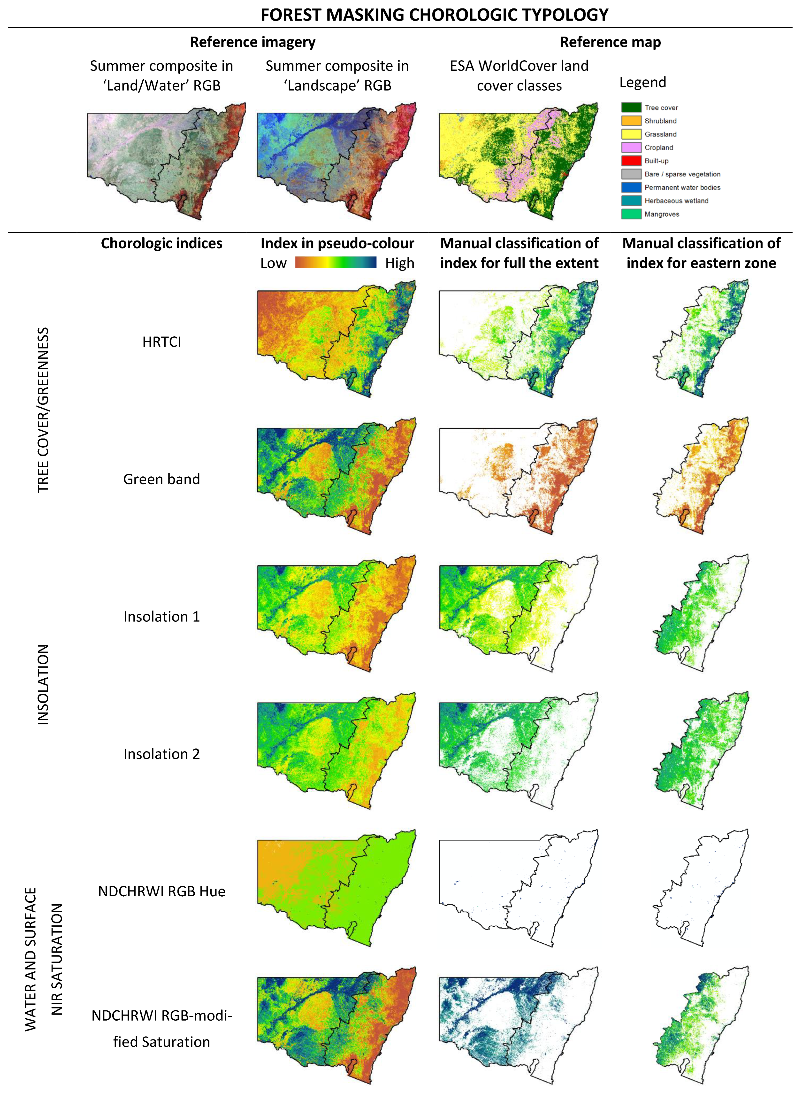
Development and Comparison of Candidate Indices with a Decision Matrix
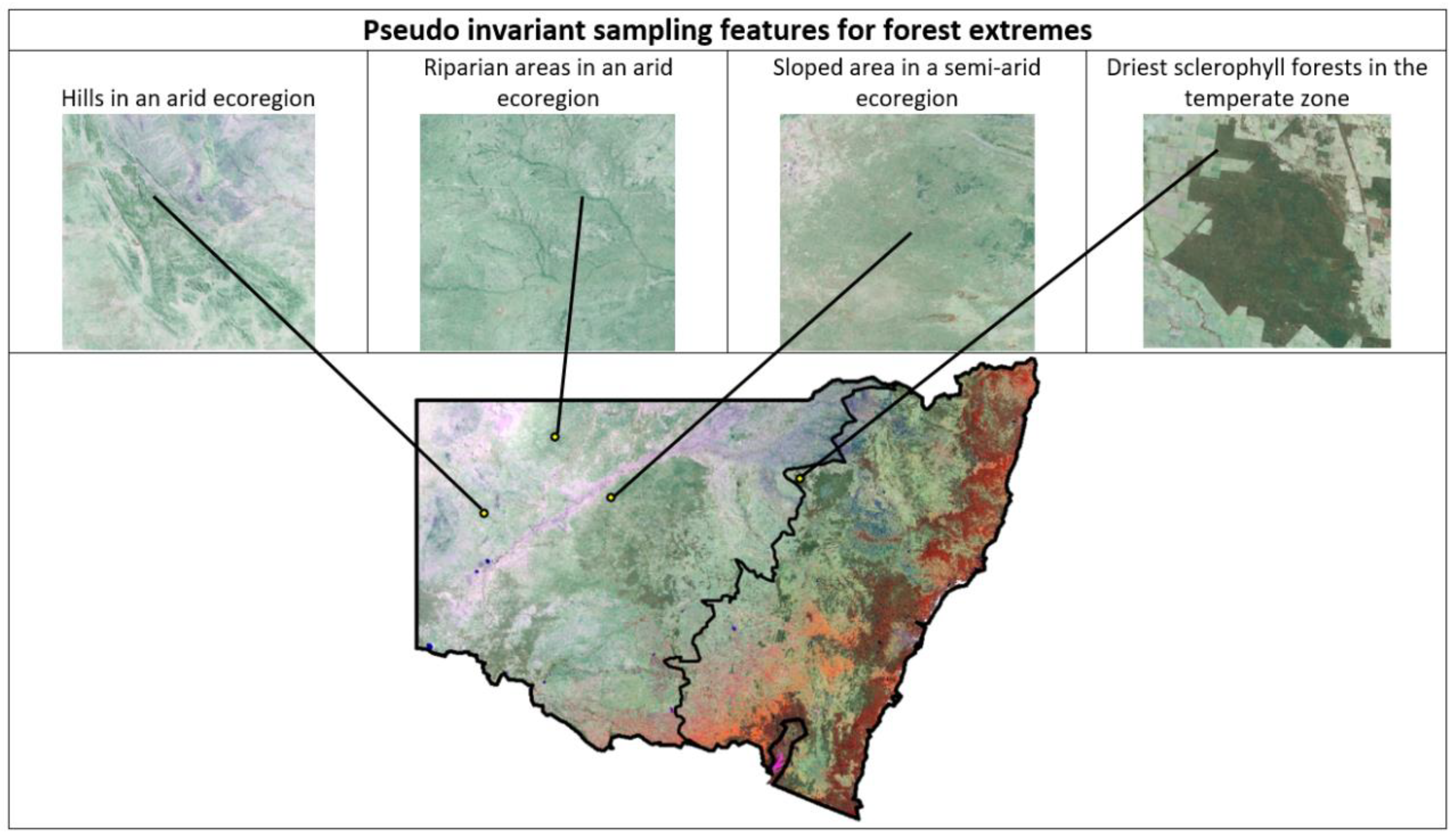
Determining Index Thresholds with Pseudo-Invariant Features (PIFs)
2.4.4. Phase 4: Development of a Colourimetrically Assisted Chorologic Typology
2.4.5. Phase 5: Spatial–Temporal Comparison of the Proposed Chorologic Typology
3. Results
3.1. Evaluation and Selection of Tree Cover Indices with a Decision Matrix
3.2. Seasonal Accuracy Comparison of the Proposed Chorologic Typology
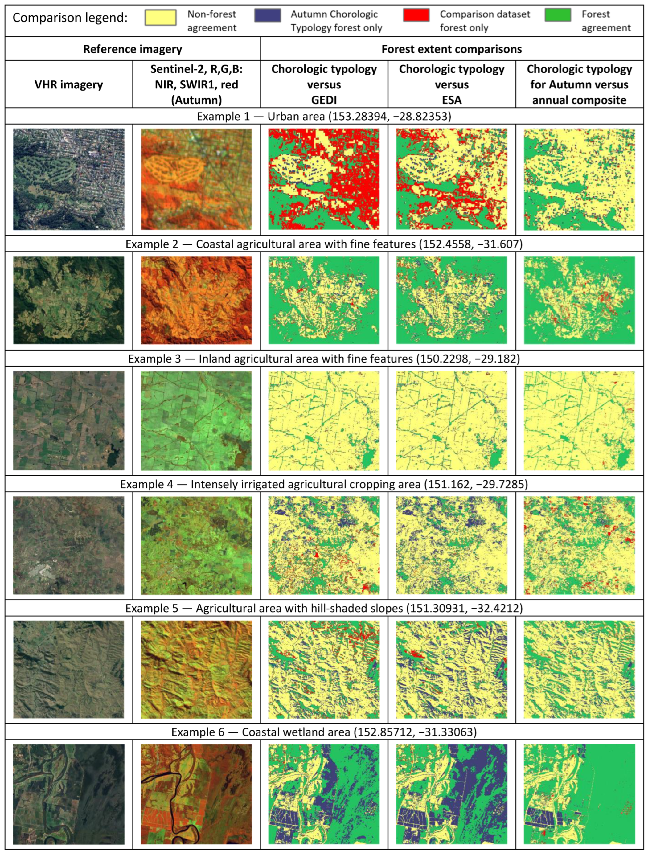
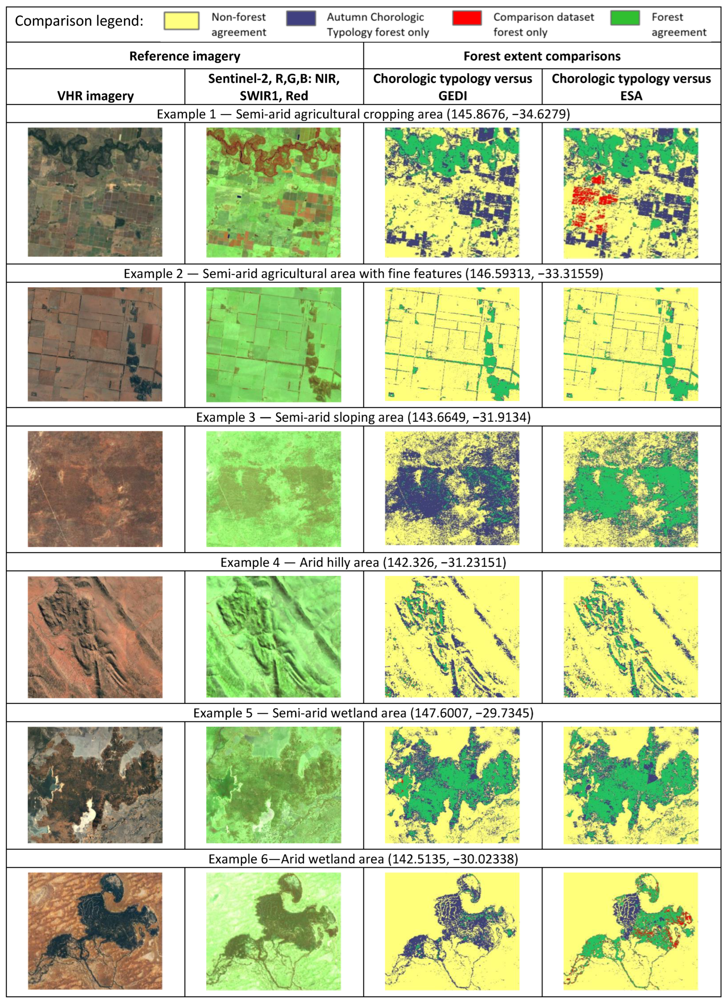
3.3. Comparison of Proposed Forest Masking with GEDI and ESA Using the Best-Performing Seasonal Composites
4. Discussion
5. Conclusions
Author Contributions
Funding
Conflicts of Interest
Appendix A
| Reference Data | Index Importance Ranking | |||||||||||
|---|---|---|---|---|---|---|---|---|---|---|---|---|
| Classes | Tree cover | Shrub land | Grass land | Crop land | Bare/sparse vegetation | Water | Herbaceous wetlands | Mangroves | Total | User accuracy | 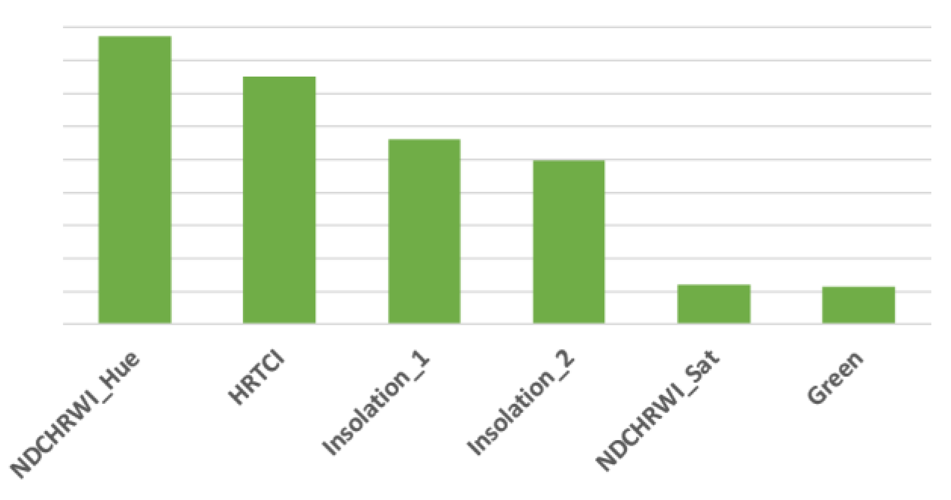 | |
| Classified data | Non-tree cover | 321 | 100 | 3523 | 978 | 54 | 36 | 29 | 1 | 5042 | 93.63 | |
| Tree cover | 4629 | 29 | 272 | 25 | 2 | 1 | 8 | 4 | 4970 | 93.14 | ||
| Total | 4950 | 129 | 3795 | 1003 | 56 | 37 | 37 | 5 | 10,012 | |||
| Producer accuracy | 93.52 | 77.52 | 92.83 | 97.51 | 96.43 | 97.30 | 78.38 | 20 | ||||
| 93.52 | 93.26 | |||||||||||
| Overall accuracy: | 93.39 | |||||||||||
| Reference Data | Index Importance Ranking | |||||||||||
|---|---|---|---|---|---|---|---|---|---|---|---|---|
| Classes | Tree cover | Shrub land | Grass land | Crop land | Bare/sparse vegetation | Water | Herbaceous wetlands | Mangroves | Total | User accuracy | 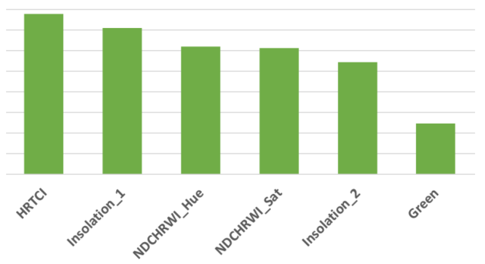 | |
| Classified data | Non-tree cover | 274 | 106 | 3547 | 983 | 53 | 36 | 28 | 1 | 5028 | 94.55 | |
| Tree cover | 4676 | 23 | 248 | 20 | 3 | 1 | 9 | 4 | 4984 | 93.82 | ||
| Total | 4950 | 129 | 3795 | 1003 | 56 | 37 | 37 | 5 | 10,012 | |||
| Producer accuracy | 94.46 | 82.17 | 93.47 | 98.01 | 94.64 | 97.30 | 75.68 | 20 | ||||
| 94.46 | 93.92 | |||||||||||
| Overall accuracy: | 94.19 | |||||||||||
| Reference Data | Index Importance Ranking | |||||||||||
|---|---|---|---|---|---|---|---|---|---|---|---|---|
| Classes | Tree cover | Shrub land | Grass land | Crop land | Bare/sparse vegetation | Water | Herbaceous wetlands | Mangroves | Total | User accuracy | 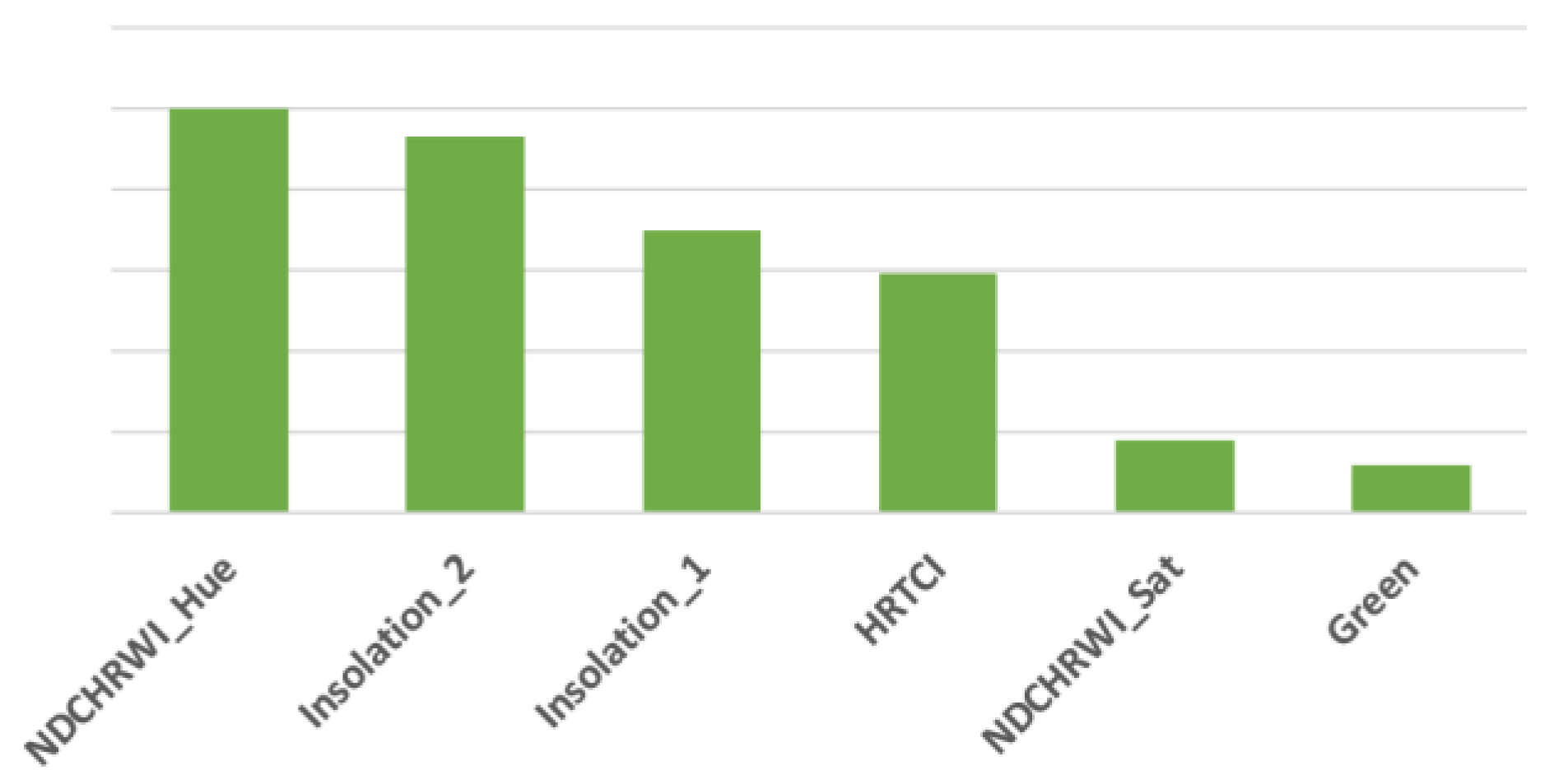 | |
| Classified data | Non-tree cover | 322 | 106 | 3564 | 970 | 55 | 36 | 30 | 0 | 5083 | 93.67 | |
| Tree cover | 4628 | 23 | 231 | 33 | 1 | 1 | 7 | 5 | 4929 | 93.89 | ||
| Total | 4950 | 129 | 3795 | 1003 | 56 | 37 | 37 | 5 | 10,012 | |||
| Producer accuracy | 93.49 | 82.17 | 93.91 | 96.71 | 98.21 | 97.30 | 81.08 | 0 | ||||
| 93.49 | 94.05 | |||||||||||
| Overall accuracy: | 93.78 | |||||||||||
| Reference Data | Index Importance Ranking | |||||||||||
|---|---|---|---|---|---|---|---|---|---|---|---|---|
| Classes | Tree cover | Shrub land | Grass land | Crop land | Bare/sparse vegetation | Water | Herbaceous wetlands | Mangroves | Total | User accuracy | 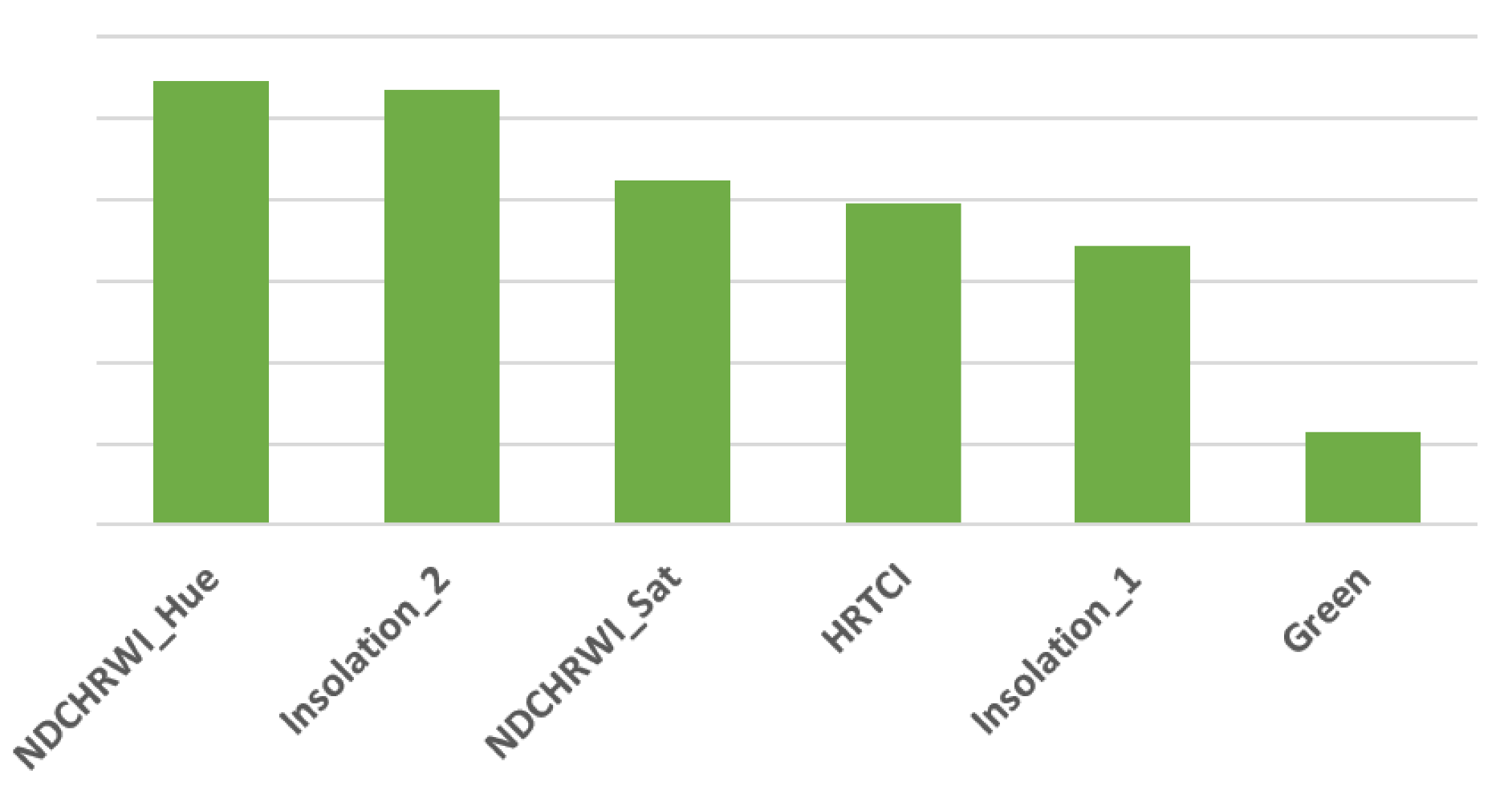 | |
| Classified data | Non-tree cover | 371 | 108 | 3545 | 958 | 55 | 37 | 27 | 0 | 5101 | 92.73 | |
| Tree cover | 4579 | 21 | 250 | 45 | 1 | 0 | 10 | 5 | 4911 | 93.24 | ||
| Total | 4950 | 129 | 3795 | 1003 | 56 | 37 | 37 | 5 | 10,012 | |||
| Producer accuracy | 92.51 | 83.72 | 93.41 | 95.51 | 98.21 | 100 | 72.97 | 0 | ||||
| 92.51 | 93.44 | |||||||||||
| Overall accuracy: | 92.98 | |||||||||||
| Reference Data | Index Importance Ranking | |||||||||||
|---|---|---|---|---|---|---|---|---|---|---|---|---|
| Classes | Tree cover | Shrub land | Grass land | Crop land | Bare/sparse vegetation | Water | Herbaceous wetlands | Mangroves | Total | User accuracy | (Could not be processed) | |
| Classified data | Non-tree cover | 290 | 107 | 3589 | 976 | 54 | 36 | 26 | 0 | 5078 | 94.29 | |
| Tree cover | 4660 | 22 | 206 | 27 | 2 | 1 | 11 | 5 | 4934 | 94.45 | ||
| Total | 4950 | 129 | 3795 | 1003 | 56 | 37 | 37 | 5 | 10,012 | |||
| Producer accuracy | 94.14 | 82.95 | 94.57 | 97.31 | 96.43 | 97.30 | 70.27 | 0 | ||||
| 94.14 | 94.59 | |||||||||||
| Overall accuracy: | 94.37 | |||||||||||
| Reference Data | Index Importance Ranking | |||||||||||
|---|---|---|---|---|---|---|---|---|---|---|---|---|
| Classes | Tree cover | Shrub land | Grass land | Crop land | Bare/sparse vegetation | Water | Herbaceous wetlands | Mangroves | Total | User accuracy | 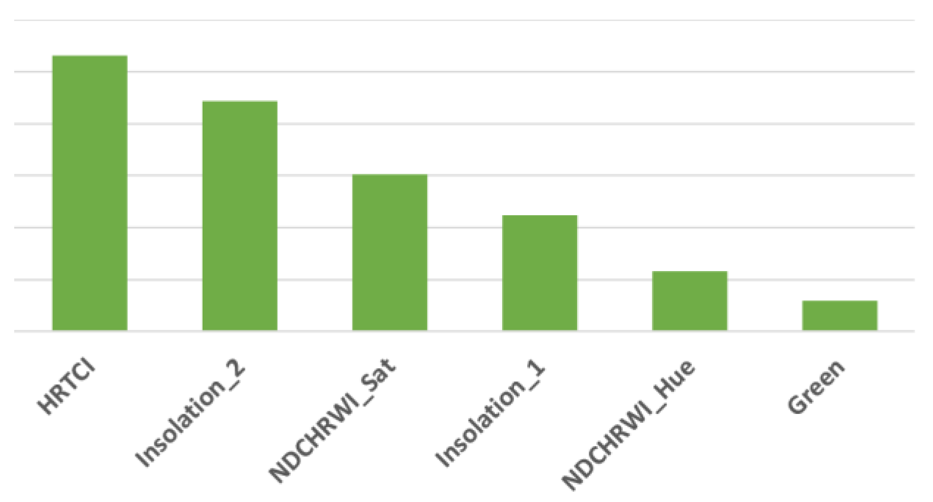 | |
| Classified data | Non-tree cover | 130 | 3 | 1619 | 684 | 23 | 27 | 5 | 2 | 2493 | 94.79 | |
| Tree cover | 2386 | 3 | 94 | 10 | 2 | 0 | 3 | 3 | 2501 | 95.40 | ||
| Total | 2516 | 6 | 1713 | 694 | 25 | 27 | 8 | 5 | 4994 | |||
| Producer accuracy | 94.83 | 50 | 94.51 | 98.56 | 92 | 100 | 62.50 | 40 | ||||
| 94.83 | 95.36 | |||||||||||
| Overall accuracy: | 95.09 | |||||||||||
| Reference Data | Index Importance Ranking | |||||||||||
|---|---|---|---|---|---|---|---|---|---|---|---|---|
| Classes | Tree cover | Shrub land | Grass land | Crop land | Bare/sparse vegetation | Water | Herbaceous wetlands | Mangroves | Total | User accuracy | 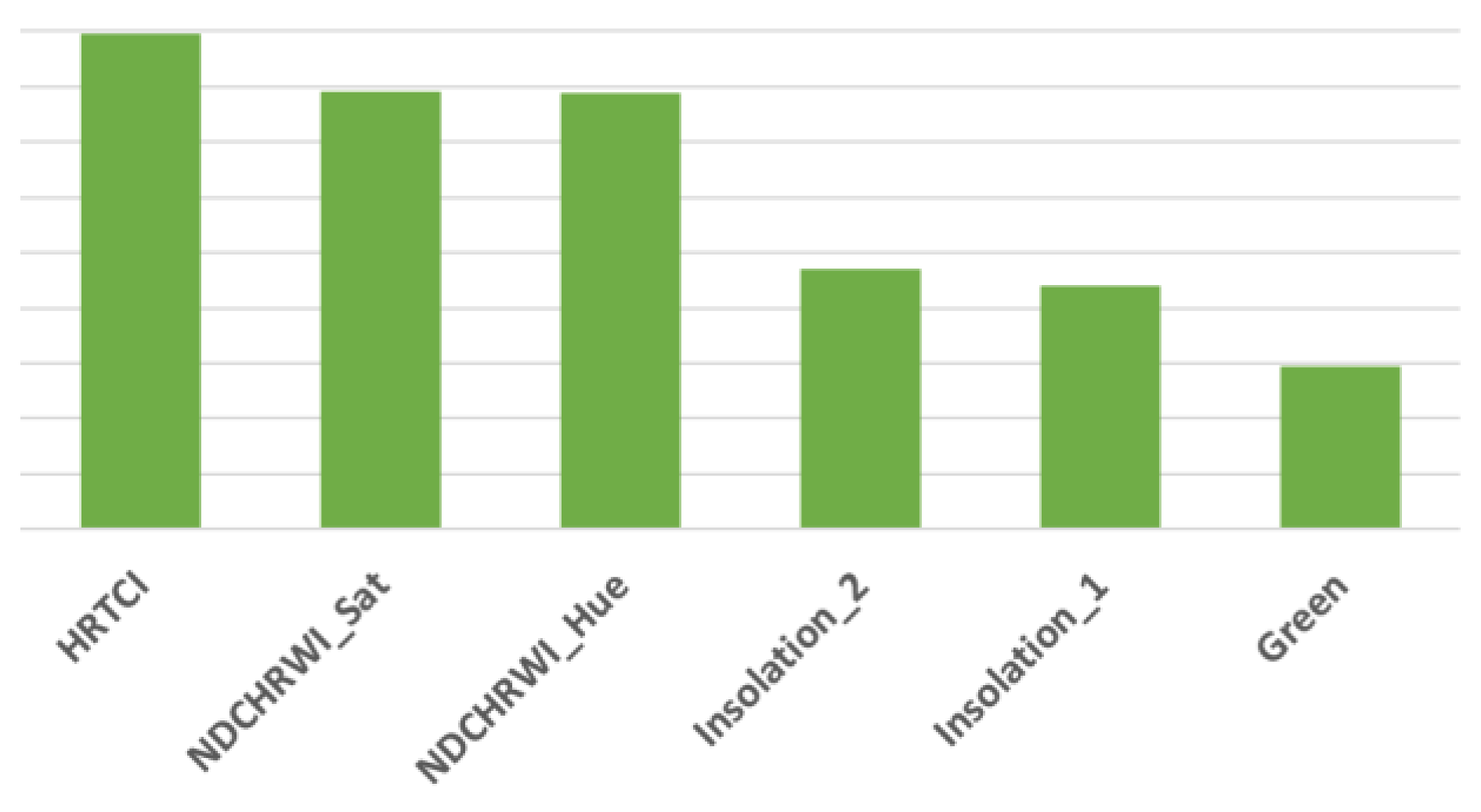 | |
| Classified data | Non-tree cover | 115 | 6 | 1636 | 687 | 24 | 27 | 2 | 1 | 2498 | 95.40 | |
| Tree cover | 2401 | 0 | 77 | 7 | 1 | 0 | 6 | 4 | 2496 | 96.19 | ||
| Total | 2516 | 6 | 1713 | 694 | 25 | 27 | 8 | 5 | 4994 | |||
| Producer accuracy | 95.43 | 100 | 95.50 | 98.99 | 96 | 100 | 25 | 20 | ||||
| 95.43 | 96.17 | |||||||||||
| Overall accuracy: | 95.79 | |||||||||||
| Reference Data | Index Importance Ranking | |||||||||||
|---|---|---|---|---|---|---|---|---|---|---|---|---|
| Classes | Tree cover | Shrub land | Grass land | Crop land | Bare/sparse vegetation | Water | Herbaceous wetlands | Mangroves | Total | User accuracy | 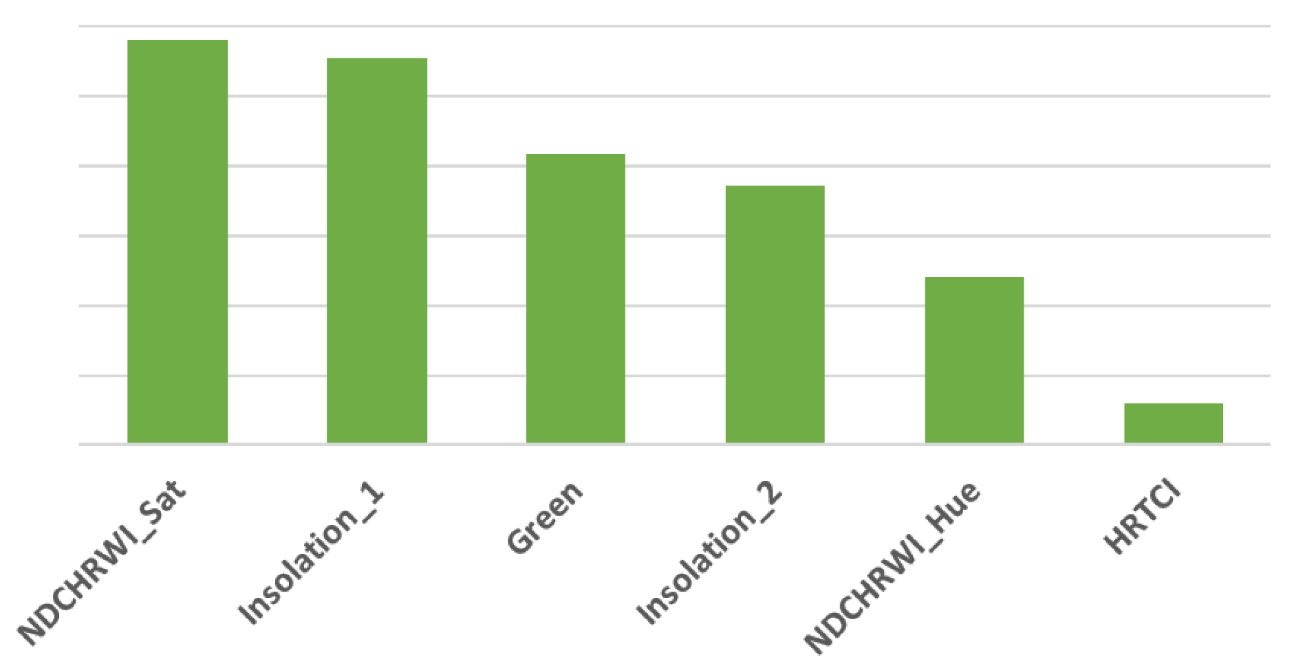 | |
| Classified data | Non-tree cover | 107 | 6 | 1614 | 680 | 24 | 26 | 5 | 1 | 2463 | 95.66 | |
| Tree cover | 2409 | 0 | 99 | 14 | 1 | 1 | 3 | 4 | 2531 | 95.18 | ||
| Total | 2516 | 6 | 1713 | 694 | 25 | 27 | 8 | 5 | 4994 | |||
| Producer accuracy | 95.75 | 100 | 94.22 | 97.98 | 96 | 96.30 | 62.50 | 20 | ||||
| 95.75 | 95.08 | |||||||||||
| Overall accuracy: | 95.41 | |||||||||||
| Reference Data | Index Importance Ranking | |||||||||||
|---|---|---|---|---|---|---|---|---|---|---|---|---|
| Classes | Tree cover | Shrub land | Grass land | Crop land | Bare/sparse vegetation | Water | Herbaceous wetlands | Mangroves | Total | User accuracy | 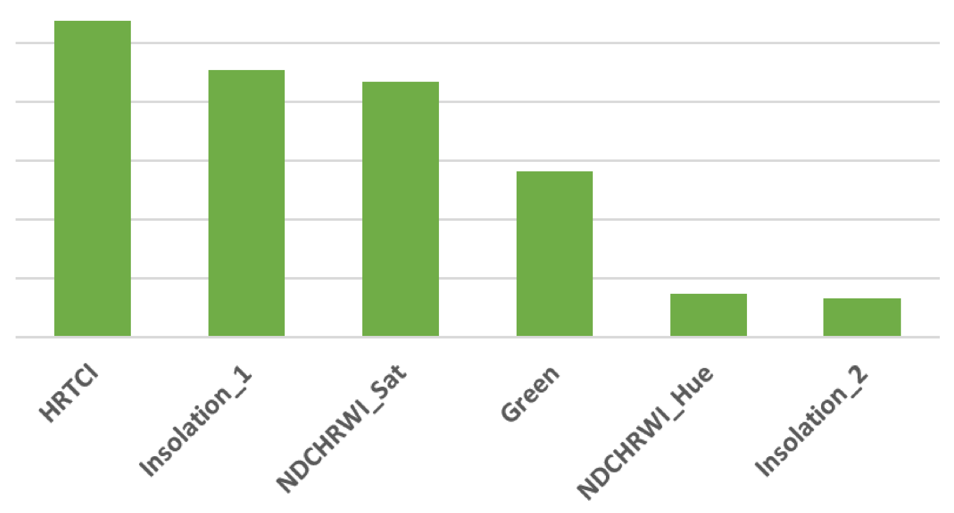 | |
| Classified data | Non-tree cover | 128 | 5 | 1632 | 680 | 24 | 27 | 2 | 0 | 2498 | 94.88 | |
| Tree cover | 2388 | 1 | 81 | 14 | 1 | 0 | 6 | 5 | 2496 | 95.67 | ||
| Total | 2516 | 6 | 1713 | 694 | 25 | 27 | 8 | 5 | 4994 | |||
| Producer accuracy | 94.91 | 83.33 | 95.27 | 97.98 | 96 | 100 | 25 | 0 | ||||
| 94.91 | 95.64 | |||||||||||
| Overall accuracy: | 95.27 | |||||||||||
| Reference Data | Index Importance Ranking | |||||||||||
|---|---|---|---|---|---|---|---|---|---|---|---|---|
| Classes | Tree cover | Shrub land | Grass land | Crop land | Bare/sparse vegetation | Water | Herbaceous wetlands | Mangroves | Total | User accuracy |  | |
| Classified data | Non-tree cover | 94 | 6 | 1627 | 689 | 24 | 27 | 2 | 0 | 2469 | 96.19 | |
| Tree cover | 2422 | 0 | 86 | 5 | 1 | 0 | 6 | 5 | 2525 | 95.92 | ||
| Total | 2516 | 6 | 1713 | 694 | 25 | 27 | 8 | 5 | 4994 | |||
| Producer accuracy | 96.26 | 100 | 94.98 | 99.28 | 96 | 100 | 25 | 0 | ||||
| 96.26 | 95.84 | |||||||||||
| Overall accuracy: | 96.06 | |||||||||||
| Reference Data | Index Importance Ranking | ||||||||||
|---|---|---|---|---|---|---|---|---|---|---|---|
| Classes | Tree cover | Shrub land | Grass land | Crop land | Bare/sparse vegetation | Water | Herbaceous wetlands | Total | User accuracy |  | |
| Classified data | Non-tree cover | 140 | 113 | 1820 | 325 | 51 | 3 | 20 | 2472 | 94.34 | |
| Tree cover | 2349 | 21 | 119 | 22 | 1 | 1 | 0 | 2513 | 93.47 | ||
| Total | 2489 | 134 | 1939 | 347 | 52 | 4 | 20 | 4985 | |||
| Producer accuracy | 94.38 | 84.33 | 93.86 | 93.66 | 98.08 | 75 | 100 | ||||
| 94.38 | 93.43 | ||||||||||
| Overall accuracy: | 93.90 | ||||||||||
| Reference Data | Index Importance Ranking | ||||||||||
|---|---|---|---|---|---|---|---|---|---|---|---|
| Classes | Tree cover | Shrub land | Grass land | Crop land | Bare/sparse vegetation | Water | Herbaceous wetlands | Total | User accuracy |  | |
| Classified data | Non-tree cover | 102 | 118 | 1855 | 336 | 51 | 4 | 20 | 2486 | 95.90 | |
| Tree cover | 2387 | 16 | 84 | 11 | 1 | 0 | 0 | 2499 | 95.52 | ||
| Total | 2489 | 134 | 1939 | 347 | 52 | 4 | 20 | 4985 | |||
| Producer accuracy | 95.90 | 88.06 | 95.67 | 96.83 | 98.08 | 100 | 100 | ||||
| 95.90 | 95.51 | ||||||||||
| Overall accuracy: | 95.71 | ||||||||||
| Reference Data | Index Importance Ranking | ||||||||||
|---|---|---|---|---|---|---|---|---|---|---|---|
| Classes | Tree cover | Shrub land | Grass land | Crop land | Bare/sparse vegetation | Water | Herbaceous wetlands | Total | User accuracy |  | |
| Classified data | Non-tree cover | 173 | 115 | 1830 | 329 | 51 | 4 | 19 | 2521 | 93.14 | |
| Tree cover | 2316 | 19 | 109 | 18 | 1 | 0 | 1 | 2464 | 93.99 | ||
| Total | 2489 | 134 | 1939 | 347 | 52 | 4 | 20 | 4985 | |||
| Producer accuracy | 93.05 | 85.82 | 94.38 | 94.81 | 98.08 | 100 | 95 | ||||
| 93.05 | 94.07 | ||||||||||
| Overall accuracy: | 93.56 | ||||||||||
| Reference Data | Index Importance Ranking | ||||||||||
|---|---|---|---|---|---|---|---|---|---|---|---|
| Classes | Tree cover | Shrub land | Grass land | Crop land | Bare/sparse vegetation | Water | Herbaceous wetlands | Total | User accuracy | 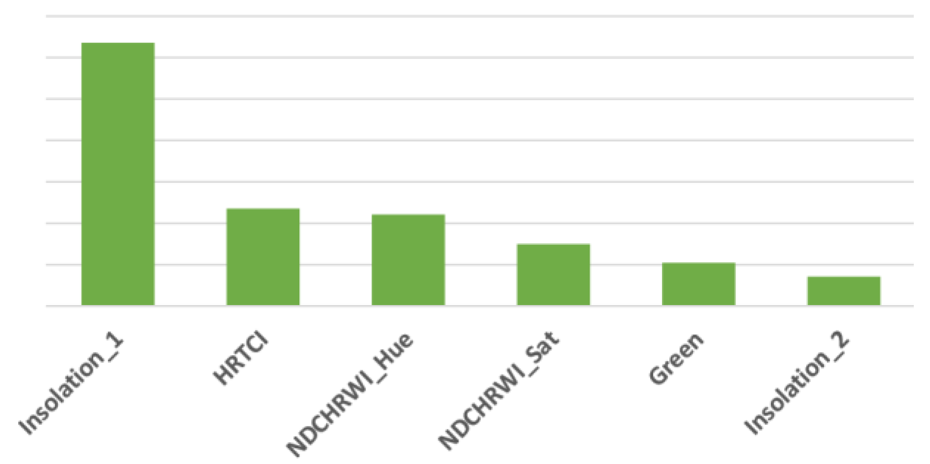 | |
| Classified data | Non-tree cover | 185 | 117 | 1801 | 316 | 51 | 4 | 20 | 2494 | 92.58 | |
| Tree cover | 2304 | 17 | 138 | 31 | 1 | 0 | 0 | 2491 | 92.49 | ||
| Total | 2489 | 134 | 1939 | 347 | 52 | 4 | 20 | 4985 | |||
| Producer accuracy | 92.57 | 87.31 | 92.88 | 91.07 | 98.08 | 100 | 100 | ||||
| 92.57 | 92.51 | ||||||||||
| Overall accuracy: | 92.54 | ||||||||||
| Reference Data | Index Importance Ranking | ||||||||||
|---|---|---|---|---|---|---|---|---|---|---|---|
| Classes | Tree cover | Shrub land | Grass land | Crop land | Bare/sparse vegetation | Water | Herbaceous wetlands | Total | User accuracy | 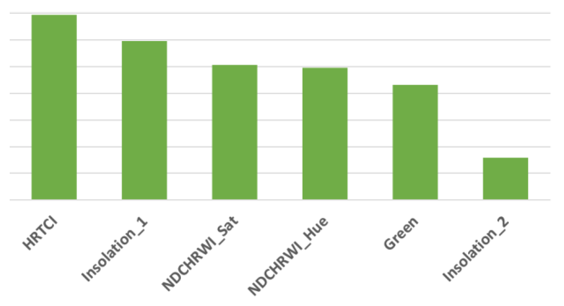 | |
| Classified data | Non-tree cover | 131 | 115 | 1852 | 325 | 51 | 4 | 20 | 2498 | 94.76 | |
| Tree cover | 2358 | 19 | 87 | 22 | 1 | 0 | 0 | 2487 | 94.81 | ||
| Total | 2489 | 134 | 1939 | 347 | 52 | 4 | 20 | 4985 | |||
| Producer accuracy | 94.74 | 85.82 | 95.51 | 93.66 | 98.08 | 100 | 100 | ||||
| 94.74 | 94.83 | ||||||||||
| Overall accuracy: | 94.78 | ||||||||||
References
- Lindenmayer, D.; Franklin, J. Conserving Forest Biodiversity: A Comprehensive Multiscaled Approach; Bibliovault OAI Repository, The University of Chicago Press: Chicago, IL, USA, 2002. [Google Scholar]
- Corlett, R.; Primack, R. Tropical Rain Forests: An Ecological and Biogeographical Comparison, 2nd ed.; John Wiley & Sons: Hoboken, NJ, USA, 2011. [Google Scholar]
- Seebach, R.L.; McCallum, I.; Fritz, S.; Kindermann, G.; Leduc, S.; Böttcher, H.; Fuss, S. Choice of forest map has implication for policy analysis: A case study on the EU biofuel target. Environ. Sci. Policy 2012, 22, 13–24. [Google Scholar] [CrossRef]
- Schepaschenko, D.; Lesiv, M.; See, L.M.; Fritz, S.; Shvidenko, A.; Perger, C.; Dürauer, M.; Kraxner, F.; Schepaschenko, M.; McCallum, I. A citizen science application for improving the spatial distribution of global forests. In Proceedings of the XIV World Forestry Congress, Durban, South Africa, 7–11 September 2015. [Google Scholar]
- Duncanson, L.; Armston, J.; Disney, M.; Avitabile, V.; Barbier, N.; Calders, K.; Carter, S.; Chave, J.; Herold, M.; Crowther, T.W.; et al. The importance of consistent validation of global forest aboveground biomass products. Surv. Geophys. 2019, 40, 979–999. [Google Scholar] [CrossRef]
- Chen, H.; Zeng, Z.; Wu, J.; Peng, L.; Lakshmi, V.; Yang, H.; Liu, J. Large Uncertainty on Forest Area Change in the Early 21st Century among Widely Used Global Land Cover Datasets. Remote Sens. 2020, 12, 3502. [Google Scholar] [CrossRef]
- Vangi, E.; D’amico, G.; Francini, S.; Giannetti, F.; Lasserre, B.; Marchetti, M.; McRoberts, R.E.; Chirici, G. The Effect of Forest Mask Quality in the Wall-to-Wall Estimation of Growing Stock Volume. Remote Sens. 2021, 13, 1038. [Google Scholar] [CrossRef]
- Yue, T.X.; Wang, Y.F.; Du, Z.P.; Zhao, M.W.; Zhang, L.L.; Zhao, N.; Lu, M.; Larocque, G.R.; Wilson, J.P. Analysing the uncertainty of estimating forest carbon stocks in China. Biogeosciences 2016, 13, 3991–4004. [Google Scholar] [CrossRef]
- Lund, H.G. rev* Definitions of Forest, Deforestation, Afforestation, and Reforestation; Misc. pagination: Note, this paper has been continuously updated since 1998; Forest Information Services: Gainesville, VA, USA, 2018. [Google Scholar] [CrossRef]
- Rajashekar, G.; Chandra, J.; Rakesh, F.; Kiran, C.T.; Suraj, R.; Jayant, S.; Sudhakar, R.C.; Jyoti, S.; Praveen, M.; Gaurav, S.; et al. Remote sensing in forest mapping, monitoring and measurement. J. Gov. 2019, 18, 18–54. [Google Scholar]
- Romijn, E.; Ainembabazi, J.H.; Wijaya, A.; Herold, M.; Angelsen, A.; Verchot, L.; Murdiyarso, D. Exploring different forest definitions and their impact on developing REDD+ reference emission levels: A case study for Indonesia. Environ. Sci. Policy 2013, 33, 246–259. [Google Scholar] [CrossRef]
- Fisher, A.; Day, M.; Gill, T.; Roff, A.; Danaher, T.; Flood, N. Large-Area, High-Resolution Tree Cover Mapping with Multi-Temporal SPOT5 Imagery, New South Wales, Australia. Remote Sens. 2016, 8, 515. [Google Scholar] [CrossRef]
- Gill, T.; Johansen, K.; Phinn, S.; Trevithick, R.; Scarth, P.; Armston, J. A method for mapping Australian woody vegetation cover by linking continental-scale field data and long-term Landsat time series. Int. J. Remote Sens. 2016, 38, 679–705. [Google Scholar] [CrossRef]
- Potapov, P.; Li, X.; Hernandez-Serna, A.; Tyukavina, A.; Hansen, M.C.; Kommareddy, A.; Pickens, A.; Turubanova, S.; Tang, H.; Silva, C.E.; et al. Mapping global forest canopy height through integration of GEDI and Landsat data. Remote Sens. Environ. 2020, 253, 112165. [Google Scholar] [CrossRef]
- Schepaschenko, D.; See, L.; Lesiv, M.; McCallum, I.; Fritz, S.; Salk, C.; Moltchanova, E.; Perger, C.; Shchepashchenko, M.; Shvidenko, A.; et al. Development of a global hybrid forest mask through the synergy of remote sensing, crowdsourcing and FAO statistics. Remote Sens. Environ. 2015, 162, 208–220. [Google Scholar] [CrossRef]
- Da Ponte, E.; Fleckenstein, M.; Leinenkugel, P.; Parker, A.; Oppelt, N.; Kuenzer, C. Tropical forest cover dynamics for Latin America using Earth observation data: A review covering the continental, regional, and local scale. Int. J. Remote Sens. 2015, 36, 3196–3242. [Google Scholar] [CrossRef]
- Avitabile, V.; Camia, A.; Pilli, R. The Biomass of European Forests. An Integrated Assessment of Forest Biomass Maps, Field Plots and National Statistics; Publications Office of the European Union: Luxembourg, 2020. [Google Scholar]
- Saah, D.; Tenneson, K.; Poortinga, A.; Nguyen, Q.; Chishtie, F.; San Aung, K.; Markert, K.; Clinton, N.; Anderson, E.; Cutter, P.; et al. Primitives as building blocks for constructing land cover maps. Int. J. Appl. Earth Obs. Geoinf. 2020, 85, 101979. [Google Scholar] [CrossRef]
- Myroniuk, V.; Kutia, M.; Sarkissian, A.J.; Bilous, A.; Liu, S. Regional-Scale Forest Mapping over Fragmented Landscapes Using Global Forest Products and Landsat Time Series Classification. Remote Sens. 2020, 12, 187. [Google Scholar] [CrossRef]
- Barnetson, J.; Phinn, S.; Scarth, P. Mapping woody vegetation cover across Australia’s arid rangelands: Utilising a machine-learning classification and low-cost Remotely Piloted Aircraft System. Int. J. Appl. Earth Obs. Geoinf. 2019, 83, 101909. [Google Scholar] [CrossRef]
- Hansen, M.C.; Potapov, P.V.; Moore, R.; Hancher, M.; Turubanova, S.A.; Tyukavina, A.; Thau, D.; Stehman, S.V.; Goetz, S.J.; Loveland, T.R.; et al. High-Resolution Global Maps of 21st-Century Forest Cover Change. Science 2013, 342, 850–853. [Google Scholar] [CrossRef]
- Hansen, M.; Potapov, P.; Margono, B.; Stehman, S.; Turubanova, S.; Tyukavina, A. Response to Comment on “High-resolution global maps of 21st-century forest cover change”. Science 2014, 344, 981. [Google Scholar] [CrossRef]
- Chazdon, R.L.; Brancalion, P.H.S.; Laestadius, L.; Bennett-Curry, A.; Buckingham, K.; Kumar, C.; Moll-Rocek, J.; Vieira, I.C.G.; Wilson, S.J. When is a forest a forest? Forest concepts and definitions in the era of forest and landscape restoration. AMBIO 2016, 45, 538–550. [Google Scholar] [CrossRef]
- Tsendbazar, N.; Li, L.; Koopman, M.; Carter, S.; Herold, M.; Georgieva, I.; Lesiv, M. WorldCover Product Validation Report V1.1. 2021. Available online: https://esa-worldcover.s3.amazonaws.com/v100/2020/docs/WorldCover_PVR_V1.1.pdf (accessed on 1 December 2022).
- Zanaga, D.; Van De Kerchove, R.; De Keersmaecker, W.; Souverijns, N.; Brockmann, C.; Quast, R.; Wevers, J.; Grosu, A.; Paccini, A.; Vergnaud, S.; et al. ESA WorldCover 10 m 2020 v100. 2021. Available online: https://developers.google.com/earth-engine/datasets/catalog/ESA_WorldCover_v100?hl=en (accessed on 1 December 2022).
- Kinnebrew, E.; Ochoa-Brito, J.I.; French, M.; Mills-Novoa, M.; Shoffner, E.; Siegel, K. Biases and limitations of Global Forest Change and author-generated land cover maps in detecting deforestation in the Amazon. PLoS ONE 2022, 17, e0268970. [Google Scholar] [CrossRef]
- Harbin, L.; Wu, J. Use and misuse of landscape indices. Landsc. Ecol. 2003, 19, 389–399. [Google Scholar]
- Wu, J.; Li, H. Concepts of Scale and Scaling; Springer: Dordrecht, The Netherlands, 2006; pp. 3–15. [Google Scholar] [CrossRef]
- Wheatley, M.; Johnson, C. Factors limiting our understanding of ecological scale. Ecol. Complex. 2009, 6, 150–159. [Google Scholar] [CrossRef]
- Richling, A.; Lechnio, J. Main aspects of system hierarchy in ecological landscape research. Misc. Geogr. Reg. Stud. Dev. 2013, 17, 5–12. [Google Scholar] [CrossRef]
- Gehlke, C.; Biehl, K. Certain Effects of Grouping upon the Size of the Correlation Coefficient in Census Track Material. J. Am. Stat. Assoc. Suppliment 1934, 29, 169–170. [Google Scholar]
- Openshaw, S. The Modifiable Areal Unit Problem; Concepts and Techniques in Modern Geography; GeoBooks: Norwich, UK, 1984; p. 38. [Google Scholar]
- Çöltekin, A.; De Sabbata, S.; Willi, C.; Vontobel, I.; Pfister, S.; Kuhn, M.; Lacayo, M. Modifiable Temporal Unit Problem; ISPRS/ICA Workshop on Persistent Problems in Geographic Visualization (ICC2011); International Cartographic Association: Paris, France, 2011; Available online: http://www.geo.unizh.ch/~sdesabba/docs/ModifiableTemporalUnitProblem.pdf (accessed on 3 July 2023).
- de Jong, R.; de Bruin, S. Linear trends in seasonal vegetation time series and the modifiable temporal unit problem. Biogeosciences 2012, 9, 71–77. [Google Scholar] [CrossRef]
- Jacquez, G. It’s about Space and Time: From the Modifiable Areal Unit Problem (MAUP) to the Modifiable Temporal Unit Problem (MTUP) to the Modifiable Spatio-Temporal Unit Problem (MSTUP). 2011. Available online: https://www.biomedware.com/its-about-space-and-time-from-the-modifiable-areal-unit-problem-maup-to-the-modifiable-temporal-unit-problem-mtup-to-the-modifiable-spatio-temporal-unit-problem-mstup/ (accessed on 22 March 2021).
- Cheng, T.; Adepeju, M. Modifiable Temporal Unit Problem (MTUP) and Its Effect on Space-Time Cluster Detection. PLoS ONE 2014, 9, e100465. [Google Scholar] [CrossRef] [PubMed]
- Avelino, A.F.T.; Baylis, K.; Honey-Rosés, J. Goldilocks and the Raster Grid: Selecting Scale when Evaluating Conservation Programs. PLoS ONE 2016, 11, e0167945. [Google Scholar] [CrossRef]
- Portillo-Quintero, C.; Sánchez-Azofeifa, G. Extent and conservation of tropical dry forests in the Americas. Biol. Conserv. 2010, 143, 144–155. [Google Scholar] [CrossRef]
- Pasquarella, V.J.; Holden, C.E.; Kaufman, L.; Woodcock, C.E. From imagery to ecology: Leveraging time series of all available Landsat observations to map and monitor ecosystem state and dynamics. Remote Sens. Ecol. Conserv. 2016, 2, 152–170. [Google Scholar] [CrossRef]
- Fotheringham, A.S. Scale-independent spatial analysis. In Accuracy of Spatial Databases; Goodchild, M., Gopal, S., Eds.; Taylor and Francis: Abingdon, UK, 1989; pp. 221–228. [Google Scholar]
- Marceau, D.; Hay, G. Remote Sensing Contributions to the Scale Issue. Can. J. Remote Sens. 1999, 25, 357–366. [Google Scholar] [CrossRef]
- Loveland, T.R.; Merchant, J.M. Ecoregions and Ecoregionalization: Geographical and Ecological Perspectives. Environ. Manag. 2004, 34, S1–S13. [Google Scholar] [CrossRef]
- Helmer, E.H.; Nicholas, R.; Goodwin, V.G.; Carlos, M.S., Jr.; Gregory, P.A. Characterizing tropical forests with multispectral imagery. In Land Resources: Monitoring, Modeling and Mapping; Thenkabail, P.S., Ed.; Taylor & Francis Group: Boca Raton, FL, USA, 2015; p. 849. [Google Scholar]
- Yarrow, M.; Stanley, S. Ecological boundaries in the context of hierarchy theory. Bio Syst. 2008, 92, 233–244. [Google Scholar] [CrossRef]
- Lawley, E.F.; Lewis, M.M.; Ostendorf, B. A remote sensing spatio-temporal framework for interpreting sparse indicators in highly variable arid landscapes. Ecol. Indic. 2016, 60, 1284–1297. [Google Scholar] [CrossRef]
- Venkatappa, M.; Sasaki, N.; Shrestha, R.P.; Tripathi, N.K.; Ma, H.-O. Determination of Vegetation Thresholds for Assessing Land Use and Land Use Changes in Cambodia using the Google Earth Engine Cloud-Computing Platform. Remote Sens. 2019, 11, 1514. [Google Scholar] [CrossRef]
- Hansen, M.; DeFries, R.; Townshend, J.; Sohlberg, R.; Dimiceli, C.; Carroll, M. Towards an operational MODIS continuous field of percent tree cover algorithm: Examples using AVHRR and MODIS data. Remote Sens. Environ. 2002, 83, 303–319. [Google Scholar] [CrossRef]
- Ustin, S.L.; Gamon, J.A. Remote sensing of plant functional types. New Phytol. 2010, 186, 795–816. [Google Scholar] [CrossRef]
- Cushman, S.A.; Littell, J.; McGarigal, K. The Problem of Ecological Scaling in Spatially Complex, Nonequilibrium Ecological Systems; Springer: Tokyo, Japan, 2010; pp. 43–63. [Google Scholar] [CrossRef]
- Colwell, J.E. Vegetation canopy reflectance. Remote Sens. Environ. 1974, 3, 175–183. [Google Scholar] [CrossRef]
- Goward, S.N.; Huemmrich, K.F.; Waring, R.H. Visible-near infrared spectral reflectance of landscape components in western Oregon. Remote Sens. Environ. 1994, 47, 190–203. [Google Scholar] [CrossRef]
- Huemmrich, K.; Goward, S. Vegetation canopy PAR absorptance and NDVI: An assessment for ten tree species with the SAIL model. Remote Sens. Environ. 1997, 61, 254–269. [Google Scholar] [CrossRef]
- Huang, C.; Song, K.; Kim, S.; Townshend, J.R.; Davis, P.; Masek, J.G.; Goward, S.N. Use of a dark object concept and support vector machines to automate forest cover change analysis. Remote Sens. Environ. 2008, 112, 970–985. [Google Scholar] [CrossRef]
- Hall, F.G.; Shimabukuro, Y.E.; Huemmrich, K.F. Remote Sensing of Forest Biophysical Structure Using Mixture Decomposition and Geometric Reflectance Models. Ecol. Appl. 1995, 5, 993–1013. [Google Scholar] [CrossRef]
- Gao, L.; Wang, X.; Johnson, B.A.; Tian, Q.; Wang, Y.; Verrelst, J.; Mu, X.; Gu, X. Remote sensing algorithms for estimation of fractional vegetation cover using pure vegetation index values: A review. ISPRS J. Photogramm. Remote Sens. 2019, 159, 364–377. [Google Scholar] [CrossRef] [PubMed]
- Kumar, L.; Schmidt, K.S.; Dury, S.; Skidmore, A.K. Review of hyperspectral remote sensing and vegetation Science. In Imaging Spectrometry: Basic Principles and Prospective Applications; Van Der Meer, F.D., De Jong, S.M., Eds.; Kluwer: Dordrecht, The Netherlands, 2001. [Google Scholar]
- Hartshorne, R. On the concept of areal differentiation. Prof. Geogr. 1962, 14, 10–12. [Google Scholar] [CrossRef]
- Johnston, R. Areal Differentiation (or Chorology). In International Encyclopedia of Geography: People, the Earth, Environment and Technology; Richardson, D., Castree, N., Goodchild, M.F., Kobayashi, A., Liu, W., Marston, R.A., Eds.; John Wiley & Sons: Hoboken, NJ, USA, 2017. [Google Scholar]
- Serrano, G.D. A Renewed Approach to the ABC Landscape Assessment Method: An Applicaton to Muntanyes d’Ordal, Barcelona Metropolitan Area. Landsc. Online 2018, 56, 1–18. [Google Scholar] [CrossRef]
- Aravena, R.A.; Lyons, M.B.; Roff, A.; Keith, D.A. A Colourimetric Approach to Ecological Remote Sensing: Case Study for the Rainforests of South-Eastern Australia. Remote Sens. 2021, 13, 2544. [Google Scholar] [CrossRef]
- Kauth, R.J.; Thomas, G.S. The Tasselled-Cap—A Graphic Description of the Spectral-Temporal Development of Agricultural Crops as Seen by Landsat. In Proceedings of the Symposium on Machine Processing of Remotely Sensed Data, Purdue University, West Lafayette, IN, USA, 29 June–1 July 1976; pp. 41–51. [Google Scholar]
- Sheykhmousa, M.; Mahdianpari, M.; Ghanbari, H.; Mohammadimanesh, F.; Ghamisi, P.; Homayouni, S. Support Vector Machine Versus Random Forest for Remote Sensing Image Classification: A Meta-Analysis and Systematic Review. IEEE J. Sel. Top. Appl. Earth Obs. Remote Sens. 2020, 13, 6308–6325. [Google Scholar] [CrossRef]
- Joblove, G.H.; Greenberg, D. Color spaces for computer graphics. Comput. Graph. 1978, 12, 20–25. [Google Scholar] [CrossRef]
- Whittaker, R.H. Communities and Ecosystems; Macmillan: New York, NY, USA, 1970. [Google Scholar]
- Dinerstein, E.; Olson, D.; Joshi, A.; Vynne, C.; Burgess, N.D.; Wikramanayake, E.; Hahn, N.; Palminteri, S.; Hedao, P.; Noss, R.; et al. An Ecoregion-Based Approach to Protecting Half the Terrestrial Realm. Bioscience 2017, 67, 534–545. [Google Scholar] [CrossRef]
- Nicholls, N. The El Niño/Southern Oscillation and Australian Vegetation. Vegetation 1991, 91, 23–36. [Google Scholar] [CrossRef]
- Broich, M.; Huete, A.; Tulbure, M.G.; Ma, X.; Xin, Q.; Paget, M.; Restrepo-Coupe, N.; Davies, K.; Devadas, R.; Held, A. Land surface phenological response to decadal climate variability across Australia using satellite remote sensing. Biogeosciences 2014, 11, 5181–5198. [Google Scholar] [CrossRef]
- Cleverly, J.; Eamus, D.; Luo, Q.; Coupe, N.R.; Kljun, N.; Ma, X.; Ewenz, C.; Li, L.; Yu, Q.; Huete, A. The importance of interacting climate modes on Australia’s contribution to global carbon cycle extremes. Sci. Rep. 2016, 6, 23113. [Google Scholar] [CrossRef]
- Moore, C.E.; Brown, T.; Keenan, T.F.; Duursma, R.A.; van Dijk, A.I.J.M.; Beringer, J.; Culvenor, D.; Evans, B.; Huete, A.; Hutley, L.B.; et al. Reviews and syntheses: Australian vegetation phenology: New insights from satellite remote sensing and digital repeat photography. Biogeosciences 2016, 13, 5085–5102. [Google Scholar] [CrossRef]
- Zhang, X.; Friedl, M.A.; Tan, B.; Goldberg, M.D.; Yu, Y. Long-Term Detection of Global Vegetation Phenology from Satellite Instruments. Phenol. Clim. Chang. 2012, 16, 297–320. [Google Scholar] [CrossRef]
- Armston, J.D.; Danaher, T.J.; Scarth, P.F.; Moffiet, T.N.; Denham, R.J. Prediction and validation of foliage projective cover from Landsat-5 TM and Landsat-7 ETM+ imagery. J. Appl. Remote Sens. 2009, 3, 033540. [Google Scholar] [CrossRef]
- Sinha, P.; Kumar, L.; Reid, N. Seasonal Variation in Land-Cover Classification Accuracy in a Diverse Region. Photogramm. Eng. Remote Sens. 2012, 78, 271–280. [Google Scholar] [CrossRef]
- Karlson, M.; Ostwald, M.; Reese, H.; Sanou, J.; Tankoano, B.; Mattsson, E. Mapping Tree Canopy Cover and Aboveground Biomass in Sudano-Sahelian Woodlands Using Landsat 8 and Random Forest. Remote Sens. 2015, 7, 10017–10041. [Google Scholar] [CrossRef]
- Schwieder, M.; Leitão, P.J.; Pinto, J.R.R.; Teixeira, A.M.C.; Pedroni, F.; Sanchez, M.; Bustamante, M.M.; Hostert, P. Landsat phenological metrics and their relation to aboveground carbon in the Brazilian Savanna. Carbon Balance Manag. 2018, 13, 1–15. [Google Scholar] [CrossRef] [PubMed]
- Schmid, R.; Keith, D. Ocean Shores to Desert Dunes: The Native Vegetation of New South Wales and the ACT. Taxon 2005, 54, 1120. [Google Scholar] [CrossRef]
- Keith, D.; Simpson, C. Vegetation Formations and Classes of NSW (Version 3.03), VIS_ID 3848; Department of Planning, Industry and Environment: Canberra, Australia, 2018.
- NSW Department of Planning and Environment. NSW Landuse 2017 v1.2; ABARES: Canberra, Australia, 2020.
- Butler, C.; Lucieer, V.; Walsh, P.; Flukes, E.; Johnson, C. Seamap Australia [Version 1.0] the Development of a National Benthic Marine Classification Scheme for the Australian Continental Shelf; Final Report to the Australian National Data Service (ANDS) High Values Collection #19; Institute for Marine and Antarctic Studies, University of Tasmania: Tasmania, Australia, 2017. [Google Scholar]
- Zonneveld, I.S. The land unit—A fundamental concept in landscape ecology, and its applications. Landsc. Ecol. 1989, 3, 67–86. [Google Scholar] [CrossRef]
- Loucks, O.L. The Epidemiology of Forest Decline in Eastern Deciduous Forests. Northeast. Nat. 1998, 5, 143. [Google Scholar] [CrossRef]
- Aravena, R.A.; Lyons, M.B.; Keith, D.A. Holistic Reduction to Compare and Create New Indices for Global Inter-Seasonal Monitoring: Case Study for High Resolution Surface Water Mapping. Remote Sens. 2023, 15, 2063. [Google Scholar] [CrossRef]
- Calderón-Loor, M.; Hadjikakou, M.; Bryan, B.A. High-resolution wall-to-wall land-cover mapping and land change assessment for Australia from 1985 to 2015. Remote Sens. Environ. 2020, 252, 112148. [Google Scholar] [CrossRef]
- Cohen, W.B.; Goward, S.N. Landsat’s Role in Ecological Applications of Remote Sensing. Bioscience 2004, 54, 535–545. [Google Scholar] [CrossRef]
- Wang, R.; Cherkauer, K.; Bowling, L. Corn Response to Climate Stress Detected with Satellite-Based NDVI Time Series. Remote Sens. 2016, 8, 269. [Google Scholar] [CrossRef]
- Jiang, Z.; Huete, A.R.; Chen, J.; Chen, Y.; Li, J.; Yan, G.; Zhang, X. Analysis of NDVI and scaled difference vegetation index retrievals of vegetation fraction. Remote Sens. Environ. 2006, 101, 366–378. [Google Scholar] [CrossRef]
- Baraldi, A.; Puzzolo, V.; Blonda, P.; Bruzzone, L.; Tarantino, C. Automatic Spectral Rule-Based Preliminary Mapping of Calibrated Landsat TM and ETM+ Images. IEEE Trans. Geosci. Remote Sens. 2006, 44, 2563–2586. [Google Scholar] [CrossRef]
- Marconcini, M.; Metz-Marconcini, A.; Üreyen, S.; Palacios-Lopez, D.; Hanke, W.; Bachofer, F.; Zeidler, J.; Esch, T.; Gorelick, N.; Kakarla, A.; et al. Outlining where humans live, the World Settlement Footprint 2015. Sci. Data 2020, 7, 242. [Google Scholar] [CrossRef]
- Simonetti, D.; Pimple, U.; Langner, A.; Marelli, A. Pan-tropical Sentinel-2 cloud-free annual composite datasets. Data Brief 2021, 39, 107488. [Google Scholar] [CrossRef]
- Hastie, T.; Tibshirani, R.; Friedman, J. The Elements of Statistical Learning, 2nd ed.; Springer: Berlin/Heidelberg, Germany, 2008; ISBN 0-387-95284-5. [Google Scholar]
- Alvarez-Vanhard, E.; Corpetti, T.; Houet, T. UAV & satellite synergies for optical remote sensing applications: A literature review. Sci. Remote Sens. 2021, 3, 100019. [Google Scholar] [CrossRef]
- Jiang, J.; Johansen, K.; Tu, Y.-H.; McCabe, M.F. Multi-sensor and multi-platform consistency and interoperability between UAV, Planet CubeSat, Sentinel-2, and Landsat reflectance data. GIScience Remote Sens. 2022, 59, 936–958. [Google Scholar] [CrossRef]
- Hashimoto, N.; Saito, Y.; Maki, M.; Homma, K. Simulation of Reflectance and Vegetation Indices for Unmanned Aerial Vehicle (UAV) Monitoring of Paddy Fields. Remote Sens. 2019, 11, 2119. [Google Scholar] [CrossRef]
- Guo, Y.; Senthilnath, J.; Wu, W.; Zhang, X.; Zeng, Z.; Huang, H. Radiometric Calibration for Multispectral Camera of Different Imaging Conditions Mounted on a UAV Platform. Sustainability 2019, 11, 978. [Google Scholar] [CrossRef]
- Revill, A.; Florence, A.; MacArthur, A.; Hoad, S.; Rees, R.; Williams, M. Quantifying Uncertainty and Bridging the Scaling Gap in the Retrieval of Leaf Area Index by Coupling Sentinel-2 and UAV Observations. Remote Sens. 2020, 12, 1843. [Google Scholar] [CrossRef]
- Francini, S.; McRoberts, R.E.; Giannetti, F.; Mencucci, M.; Marchetti, M.; Mugnozza, G.S.; Chirici, G. Near-real time forest change detection using PlanetScope imagery. Eur. J. Remote Sens. 2020, 53, 233–244. [Google Scholar] [CrossRef]
- Herndon, K.; Muench, R.; Cherrington, E.; Griffin, R. An Assessment of Surface Water Detection Methods for Water Resource Management in the Nigerien Sahel. Sensors 2020, 20, 431. [Google Scholar] [CrossRef] [PubMed]
- Descalsferrando, A.; Verger, A.; Yin, G.; Penuelas, J. A Threshold Method for Robust and Fast Estimation of Land-Surface Phenology Using Google Earth Engine. IEEE J. Sel. Top. Appl. Earth Obs. Remote Sens. 2020, 14, 601–606. [Google Scholar] [CrossRef]


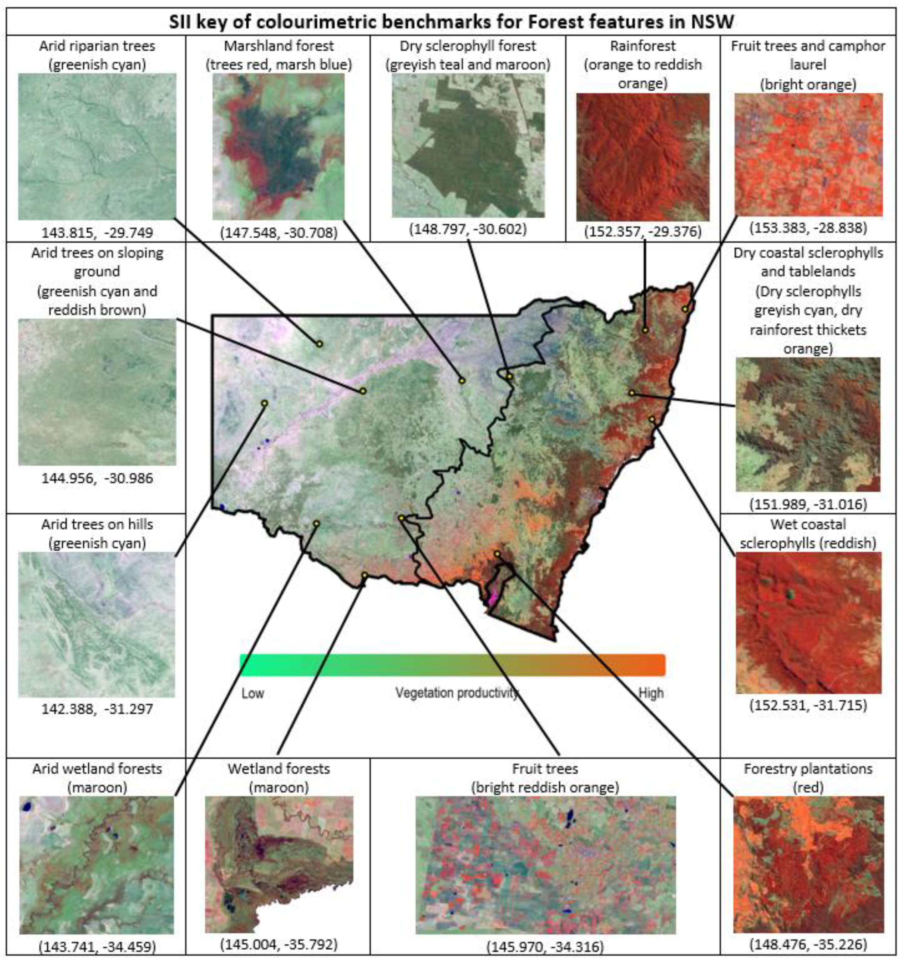
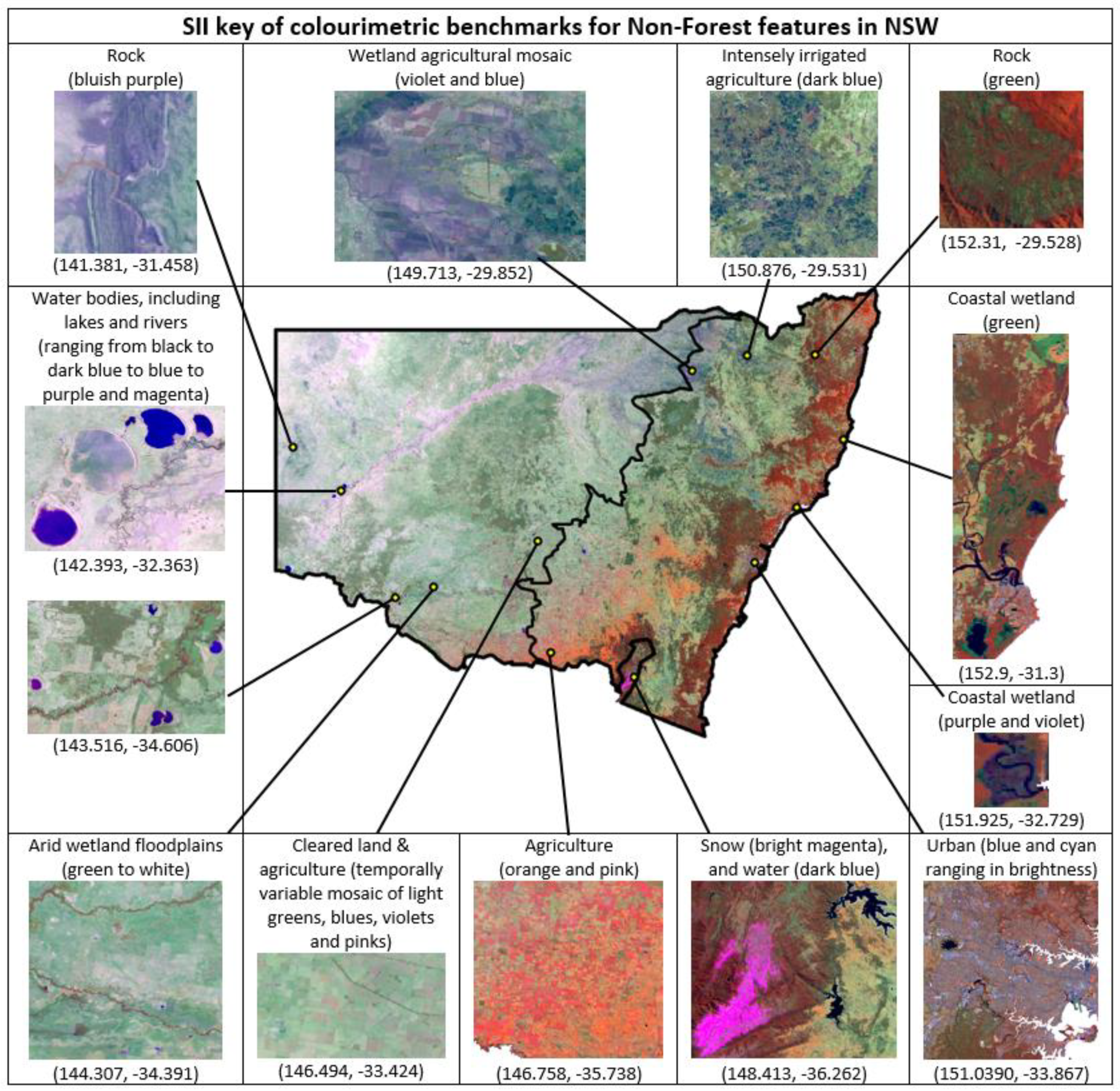
| Equation | Number |
|---|---|
| NDVI = (B4 − B3)/(B4 + B3) | (1) |
| B2 | (2) |
| (B1 − B2)/B3 | (3) |
| (B4/B2) − (B4/B1) | (4) |
| (B4/B2 − B4/B1)/B2 | (5) |
| (B4/B2 − B4/B1)/(B3 + B2) | (6) |
| (B4/B2 − B4/B1)/(B3/B2) | (7) |
| (B4/B2 − B4/B1)/(B3 + B2 + B1) | (8) |
| ((B4/B2 − B4/B1)/B3) − ((B4/B2 − B4/B1)/B4) | (9) |
| Criteria | 1 | 2 | 3 | 4 | 5 | 6 | 7 | 8 | 9 | |
|---|---|---|---|---|---|---|---|---|---|---|
| Overlap of spectrally similar features | Overlaps clear water (−1) | 0 | −1 | −1 | −1 | −1 | −1 | −1 | −1 | 0 |
| Overlaps turbid water (−1) | 0 | 0 | 0 | 0 | 0 | 0 | 0 | 0 | −1 | |
| Overlaps built-up features (buildings, roads & mining) (−1) | −1 | 0 | −1 | −1 | −1 | −1 | −1 | −1 | −1 | |
| Overlaps orange agriculture with sclerophyll range in Summer or Winter (−1 if moderately, −2 if excessively) | −2 | 0 | 0 | 0 | 0 | 0 | 0 | 0 | 0 | |
| Overlaps blue agriculture excessively in one or more seasons (−1) | 0 | 0 | −1 | 0 | 0 | 0 | −1 | 0 | 0 | |
| Overlaps bright greenish agriculture excessively in one or more seasons (−1) | −1 | 0 | 0 | 0 | 0 | 0 | 0 | 0 | 0 | |
| Overlaps coastal wetlands (particularly sedgelands) (−1) | −1 | −1 | −1 | −1 | −1 | −1 | −1 | −1 | −1 | |
| Overlaps inland wetlands (−1) | 0 | 0 | −1 | −1 | −1 | −1 | −1 | −1 | −1 | |
| Gradient and Seasonality | Gradient conforms to local reference of vegetation formations across seasons (+1 if generally or for most seasons, +2 if for all seasons) | 1 | 1 | 1 | 1 | 1 | 2 | 1 | 2 | 2 |
| Displays variation in quantile distribution across the seasons (−1) | 0 | 0 | −1 | 0 | 0 | 0 | −1 | 0 | 0 | |
| Illumination effects | Displays erroneous hill shading effects in mountainous areas during Winter, with forested hill shades classified as non-forest (−1 if minimally, −2 if excessively) | −2 | 0 | 0 | −2 | 0 | 0 | 0 | −1 | −1 |
| Displays atmospheric illumination imbalances across satellite flight paths (−1) | 0 | −1 | 0 | 0 | −1 | 0 | 0 | 0 | 0 | |
| Score: | −6 | −2 | −5 | −5 | −4 | −2 | −5 | −3 | −3 |
| User Accuracy (%) | Producer Accuracy (%) | Overall Accuracy (%) | Ranking | ||||
|---|---|---|---|---|---|---|---|
| Season | Tree | Non-Tree | Tree | Non-Tree | |||
| Full extent | Summer | 93.14 | 93.63 | 93.52 | 93.26 | 93.39 | 4 |
| Autumn | 93.82 | 94.55 | 94.46 | 93.92 | 94.19 | 2 | |
| Winter | 93.89 | 93.67 | 93.49 | 94.05 | 93.78 | 3 | |
| Spring | 93.24 | 92.73 | 92.51 | 93.44 | 92.98 | 5 | |
| Annual | 94.45 | 94.29 | 94.14 | 94.59 | 94.37 | 1 | |
| Eastern zone | Summer | 95.40 | 94.79 | 94.83 | 95.36 | 95.09 | 5 |
| Autumn | 96.19 | 95.40 | 95.43 | 96.17 | 95.79 | 2 | |
| Winter | 95.18 | 95.66 | 95.75 | 95.08 | 95.41 | 3 | |
| Spring | 95.67 | 94.88 | 94.91 | 95.64 | 95.27 | 4 | |
| Annual | 95.92 | 96.19 | 96.26 | 95.84 | 96.06 | 1 | |
| Western zone | Summer | 93.47 | 94.34 | 94.38 | 93.43 | 93.90 | 3 |
| Autumn | 95.52 | 95.90 | 95.90 | 95.51 | 95.71 | 1 | |
| Winter | 93.99 | 93.14 | 93.05 | 94.07 | 93.56 | 4 | |
| Spring | 92.49 | 92.58 | 92.57 | 92.51 | 92.54 | 5 | |
| Annual | 94.81 | 94.76 | 94.74 | 94.83 | 94.78 | 2 | |
Disclaimer/Publisher’s Note: The statements, opinions and data contained in all publications are solely those of the individual author(s) and contributor(s) and not of MDPI and/or the editor(s). MDPI and/or the editor(s) disclaim responsibility for any injury to people or property resulting from any ideas, methods, instructions or products referred to in the content. |
© 2023 by the authors. Licensee MDPI, Basel, Switzerland. This article is an open access article distributed under the terms and conditions of the Creative Commons Attribution (CC BY) license (https://creativecommons.org/licenses/by/4.0/).
Share and Cite
Aravena, R.A.; Lyons, M.B.; Keith, D.A. High Resolution Forest Masking for Seasonal Monitoring with a Regionalized and Colourimetrically Assisted Chorologic Typology. Remote Sens. 2023, 15, 3457. https://doi.org/10.3390/rs15143457
Aravena RA, Lyons MB, Keith DA. High Resolution Forest Masking for Seasonal Monitoring with a Regionalized and Colourimetrically Assisted Chorologic Typology. Remote Sensing. 2023; 15(14):3457. https://doi.org/10.3390/rs15143457
Chicago/Turabian StyleAravena, Ricardo A., Mitchell B. Lyons, and David A. Keith. 2023. "High Resolution Forest Masking for Seasonal Monitoring with a Regionalized and Colourimetrically Assisted Chorologic Typology" Remote Sensing 15, no. 14: 3457. https://doi.org/10.3390/rs15143457
APA StyleAravena, R. A., Lyons, M. B., & Keith, D. A. (2023). High Resolution Forest Masking for Seasonal Monitoring with a Regionalized and Colourimetrically Assisted Chorologic Typology. Remote Sensing, 15(14), 3457. https://doi.org/10.3390/rs15143457


