Article

Quantitative Assessment of Sea Surface Salinity Estimates Using a High-Frequency Radar in Ise Bay, Japan

1
Graduate School of Engineering and Science, University of the Ryukyus, 1 Senbaru, Nishihara 903-0213, Okinawa, Japan
2
Faculty of Engineering, University of the Ryukyus, 1 Senbaru, Nishihara 903-0213, Okinawa, Japan
*
Author to whom correspondence should be addressed.
Remote Sens. 2023, 15(12), 3088; https://doi.org/10.3390/rs15123088
Submission received: 10 May 2023 / Revised: 9 June 2023 / Accepted: 10 June 2023 / Published: 13 June 2023

Abstract

:
Changes in sea surface salinity (SSS) caused by the discharge of freshwater plumes from rivers affect the marine environment in estuaries; therefore, monitoring SSS is essential for understanding the changes in physical phenomena within coastal ecosystems induced by river plume discharge. Previous studies showed that salinity could be estimated using a very-high-frequency radar; however, this method was only validated over a short period and few qualitative evaluations were performed. Therefore, to verify quantitative assessments of SSS estimates for practical use, we estimated SSS using the Doppler spectrum of a 24.5-MHz phased-array high-frequency (HF) radar installed in Ise Bay, Japan, and data of approximately 1 year were used for verification. The radar-estimated SSS map was consistent with the velocity field and salinity distribution reported in previous studies. The root mean square error (RMSE) of the SSS estimate for 1-h radar data compared with in situ observations was 4.42 psu when the effect of wind on the received power was removed and 5.04 psu when it was not. For the daily (25-h) average, the RMSE when the effect of wind was considered was 3.32 psu. These results were considered sufficiently applicable in closed coastal areas such as Ise Bay, where the SSS decreases rapidly by 10 psu or more due to river flooding. The results revealed that the HF radar, which can continuously measure sea surface velocity and SSS with a high spatiotemporal resolution, can be a useful tool for providing a deeper understanding of the physical and environmental phenomena that are greatly affected by river water discharge.

1. Introduction

In coastal areas with estuaries and brackish water, freshwater plumes from rivers affect flow conditions by changing the density of sea water. Additionally, large amounts of organic matter in these water plumes significantly impact these ecosystems and may cause significant damage to local fishing industries. Thus, monitoring sea salinity is essential for an improved understanding of the changes in the physical phenomena in coastal ecosystems affected by the discharge of riverine water plumes.
A high-frequency (HF) radar has the unique ability to continuously monitor a wide range of sea surface current velocities and is widely used in regional- or national-level networks [1,2,3,4]. The HF radar has features that are advantageous for disaster prevention, such as the detection of tsunami currents [5,6,7] and observation of subsequent natural oscillations induced by tsunami waves [8,9]. Furthermore, recent studies have indicated that HF radars can be used to measure ocean wave parameters [10,11,12] and wind speed and direction [13,14,15], and these applications have been reviewed by Lorente et al. [4]. However, these factors can only be measured when the scattered echo from the sea surface is sufficiently strong. The backscattered power depends on the surface conductivity, and the conductivity of sea water is primarily determined by the salinity. Thus, when sea surface salinity (SSS) decreases (e.g., due to freshwater inputs from rivers), the received power also decreases. Consequently, data acquisition is interrupted due to the decline in the signal-to-noise ratio, which in turn interferes with the smooth operation of the HF radar. In addition, the sea state affects radar operation because it may cause propagation loss. Recent studies have reported that the performance of the HF radar for freshwater bodies [16,17,18,19] changes based on electrical conductivity, wind speed, and tides, thereby reducing the data acquisition rates near coastal river plumes [20]. These findings provide more practical insights into actual radar operations in low-salinity areas based on the sea states in the observation area.
The significant effect of salinity on radar observations suggests that the HF radar is capable of monitoring salinity. A previous study has investigated the effect of salinity on HF radio waves incident on rock salt [21]. Yoshii [22] used the relationship among salinity, wind, and phased-array type very-high-frequency (VHF) (42 MHz) radar data acquired in Ariake Bay [23], proposed a method of measuring electrical conductivity by utilizing first-order peaks from VHF radar observations, and demonstrated the potential of VHF radar in SSS evaluations. However, the proposed method was validated over a short period, and limited qualitative evaluations were performed. In addition, as the effect of electrical conductivity on received power is related to the frequency of radio waves, the applicability to the HF radar remains unknown. Therefore, for the practical performance of SSS estimates by the HF radar, which is widely used in coastal areas, a quantitative index of SSS accuracy based on long-term observations is required.
Three large-scale rivers (Kiso, Ibi, and Nagara rivers, known collectively as the Kiso Three Rivers) flow into Ise Bay from the inner part of the bay, which lies on the southern side of Honshu Island. In an enclosed bay, inflows of river water from the bay head and seawater from the mouth of the bay affect the environment. The salinity change caused by these phenomena has a significant impact on the environment, which affects the flow regime and ecosystem of the bay. Therefore, continuous salinity measurements are essential to understanding the environment in coastal areas. Satellites are generally used to measure salinity changes induced by large-scale oceanic phenomena such as the global water cycle. However, due to limitations in spatiotemporal resolution (typically 30–300 km) and long revisiting time (≥3 d), satellite-based SSS estimates using microwave measurements (L-band radiometers) do not provide adequate data in rapidly changing coastal areas [24,25,26]. In situ observations, such as by conductivity temperature depth profiler and survey ships, have limited spatial and temporal coverage and are comparatively expensive. If HF radars can observe SSS in addition to sea surface velocities with a comparatively high spatiotemporal resolution, the function of these radars can be maximized while the observation costs can be minimized. Continuous tracking of river plumes will provide a better understanding of their impact on coastal ecosystems and fisheries and contribute to more in-depth studies of estuaries and coastal zones.
However, the use of the HF radar to estimate SSS must be verified and the method must be further investigated before it is used in practical applications. Based on methods proposed in previous studies [22,23], the present study involved a quantitative assessment of SSS estimates using a 24.5 MHz HF radar installed in Ise Bay and data of approximately 1 year (collected in 2016), and the SSS values estimated by the radar were compared to in situ data collected by an observation buoy. Initially, we explored the factors that affect the received power of the radar. Next, we obtained the relational expressions between those factors and the received power of the radar based on in situ observations from May to July. The relational expressions were used to estimate SSS from August to December, and in situ observations were used to evaluate the SSS estimates. Finally, we discussed the influence of different radio wave frequencies on the SSS estimates.

2. Materials and Methods

2.1. Study Site

Ise Bay is a semi-enclosed bay located in the southern part of central Honshu Island (Figure 1). It has a surface area of 1738 km2 and water volume of 33.9 km3. The bay mouth is narrow, and the three major rivers that flow into the bay head are known collectively as the Kiso Three Rivers. Despite its extensive water area, the seawater capacity of the bay is limited due to its relatively shallow depth (20 m average). Thus, the sea condition is strongly influenced by discharge from the Kiso Three Rivers, and such inputs are significantly affected by the season. For example, a discharge peak is observed during the rainy season in summer and is several times higher than the discharge observed during the dry season in winter [27].

2.2. Materials

For environmental monitoring in Ise Bay, the Ministry of Land, Infrastructure, Transport and Tourism (MILT) of Japan performs HF radar observations to examine the sea surface velocity. Data are obtained every 1 h from the 24.5 MHz digital beamforming (DBF) phased-array radars (NABE, MA, and OM in Figure 1). To estimate SSS by HF radar, the relationship between the electric conductivity and wind speed and received power must be predetermined because they are major factors that change the received power. In this study, we used the received power obtained by the radar NABE installed at the head of the bay at Nabeta in Aichi prefecture since 2014. The system specifications of the radar are shown in Table 1. Radial velocities are calculated from the 256-point Doppler spectra. The range and angular resolution are 1.5 km and 7.5°, respectively. The radar observation area spans the bay head near the mouth of the river to the bay mouth, where it connects to the ocean.
Meteorological and water quality data are continuously collected by both an observational tower and a buoy located in the sea in the inner part of the bay (St.1 in Figure 1) approximately 11 km from the radar site. SSS, sea surface temperature (SST), and wind are measured at 1 m water depth and 1 m above sea level, respectively. The SSS and wind are shown in Figure 2c,d, respectively. In this study, these data were downloaded from the MILT website [28]. Electrical conductivity can be calculated if the salinity and water temperature are known; thus, we calculated electrical conductivity from these SSS and SST data. The discharge values of the Kiso River, which has the highest discharge among the Kiso Three Rivers, were obtained from the water information system database of the MILT [29] and are shown in Figure 2b. These values were used to display the relationship between river discharge and decreases in SSS. A survey vessel operated by the Japan Coast Guard (JCG) collects monthly SST data in Ise Bay [30], and these data were used to convert the radar-estimated conductivity to SSS. To understand the relationship between the spatial distribution of SSS and tides, tide gauge data in Onizaki (Shown in Figure 1) were used.

2.3. Theory and Methods

2.3.1. Effects of the Wave Spectrum and SSS on Received Power

SSS was estimated based on the radar received power [22]. Sea water conductivity is a function of salinity and sea temperature, and it is nearly proportional to the salinity at a given temperature. Thus, we initially examined the effect of conductivity on the radar received power based on the radar equation. As the scattering patch increases with the radar range, the radar received power density P r e c backscattered by the water surface patch distance R from the radar is ideally expressed as follows [18]:
P r e c = P t G t σ b A s A r 4 π R 2 2 A 4 ,
where P t is the transmitted power, G t is the gain of the transmitting antenna, σ b is the radar cross section (RCS), A s is the (range-dependent) area of the surface scattering element (generally the radar resolution cell), A r is the effective area of the receiving antenna, and A is the attenuation factor. Similar to Fernandez et al. [18], considering that A s is directly proportional to the range, Equation (1) can be written by combining constants that are independent of propagation using the constant parameter β :
P r e c = β σ b R 3 A 4 .
In this case, only changes of the attenuation factor A and RCS σ b affect the received power at distance R .
For the first-order RCS σ b , Barrick [31] formulated it as follows:
σ b ω D = 2 6 π k 0 4 m = ± 1 S 2 m k 0 δ ω D m ω b ,
where S · is the ocean wave spectrum receding and approaching the radar site, k 0 is the radar wave number, δ · is the Dirac function, ω D is the angular Doppler frequency, and ω b is the angular Bragg frequency. This equation considers the sea surface as a perfect conductor. However, the conductivity of sea water may also influence the RCS [32]. To illustrate the possible ground-wave propagation conditions, the effect of the complex relative permittivity κ of the lower medium on RCS should be considered [17,33], as shown below:
κ = ε + j σ ω ε 0 ,
where ε is the real relative permittivity, ε 0 is the absolute permittivity in vacuum ( ε 0 = 8.854 × 10 12   F / m ), ω is the angular frequency of radio waves, and σ is the surface conductivity. Both sea water and fresh water have ε = 80 as a constant value. Thus, for the first-order RCS in an imperfect conductor with a specific radar frequency, we can only consider the change of σ . Therefore, Equation (3) can be rewritten using X σ , the function of the conductivity, as follows:
σ b ω D = 2 6 π k 0 4 X σ m = ± 1 S 2 m k 0 δ ω D m ω b .
X σ is considered to include the incident angle to the sea surface [34,35]. However, we only considered the conductivity in this study.
The attenuation factor A is estimated by empirical approximations derived from Knight and Robson [36]:
A = A 0 A 0 A 90 sin b .
In the above equation,
A 0 = 2 + 0.33 p 2 + p + 0.6 p 2 ,
A 90 = 2 + 170 p 2 + 210 p + 310 p 2 ,
b = tan 1 ε + 1 60 σ λ ,   and
p = π R λ 1 ε + 1 2 + 60 σ λ 2 ,
where σ and ε are the surface conductivity and relative surface permittivity of the lower medium in the propagation path, as in Equation (4), respectively, and λ is the radar wavelength. The attenuation term is primarily affected by electrical conductivity because the permittivity of seawater remains relatively unchanged regardless of water quality, as previously mentioned. Figure 3a shows the relationship between the attenuation factor A and distance R for a 24.5 MHz HF radar with conductivity σ as a parameter. The curves are normalized based on the value at 4 S/m and 1 km. Figure 3a shows that the attenuation factor A was almost inversely proportional to R 1 at distances > 10 km from the radar, regardless of the σ value. Figure 3b shows the result of subtracting R 1 from A , which implies that changes in A are dependent only on conductivity and independent of distance when the distance from the radar is greater than approximately 10 km.
Considering the previous equations, Equation (1) can be simplified as follows:
P σ , R = S ± 2 k · X σ · A σ , R · D R · B ,
where S · , X · , and D · are the wave spectra, RCS terms affected by electrical conductivity in Equation (5), and distance term, respectively. B shows the terms that are not mentioned above and miscellaneous loss caused by radar systems. By taking the logarithm 10log10 of both sides of Equation (11), the following form can be obtained:
P σ , R = S ± 2 k + X σ + A σ , R + D ( R ) + B .
Hereafter, these variables are shown in units of decibel (dB). In general, the value of P is difficult to determine using this equation because of the difficulty in estimating the precise value of B , which is affected by physical or mechanical factors.
This effect will be removed by assuming that B is time-invariant and calculating Δ P , which is the difference between the measured power and pre-measured power in a known specific condition (hereafter referred as the “reference value”). The reference value of P is calculated by averaging over a period in which wave spectra and conductivity are known. P at the same observation point is shown as follows:
Δ P σ , R = S 1 ± 2 k + X σ 1 + A σ 1 , R + D ( R ) + B ,   and S 0 ± 2 k X σ 0 A σ 0 , R D ( R ) B ,
where the subindices 1 and 0 indicate the measurement and reference values, respectively. According to Figure 3a,b, assuming that the attenuation depends on changes in conductivity and is nearly constant at a distance > 10 km from the radar site, we can divide the attenuation factor A σ , R into effects based on conductivity A 1 and distance A 2 :
A σ , R = A 1 σ + A 2 R .
After inserting Equation (14) into Equation (13):
Δ P σ = S 1 S 0 + X σ 1 + A 1 σ 1 X σ 0 + A 1 σ 0 , = S 1 S 0 + Z σ 1 Z σ 0 = Δ S + Δ Z .
We combined X and A 1 , which represent the effect of conductivity on RCS and the propagation attenuation, respectively, into Z . Note that attenuation factor A involves conductivity at all points on the propagation path between the radar and observation point; however, we ignored this effect and assumed that the conductivity within the observation area was uniform. If conductivity was estimated by Equation (15), then SSS was calculated based on SST.
To estimate the SSS distribution map, Equation (15) obtained by St.1 was applied to each observation point. Figure 3c shows the relationship between the attenuation factor A and conductivity σ with distance R as a parameter, and Figure 3d shows the result obtained by subtracting R 1 from A . The characteristic curves had almost the same shape for distances > 10 km. This suggested that the characteristics obtained at St.1 were applicable at least to the other radar observation points located at distances greater than approximately 10 km from the radar. The wave spectrum term Δ S in Equation (15) was ignored when estimating the SSS map because the wind speed and direction at each observation point were unknown and the wind state at St.1 could not be considered representative of the entire bay. Therefore, only the received power of the radar and the assumption of SST were used to obtain the salinity distribution. The term Δ S was used only for comparison with in situ observation point St.1.

2.3.2. Radar Observation Point for Obtaining the Reference Values and Definition of Received Power

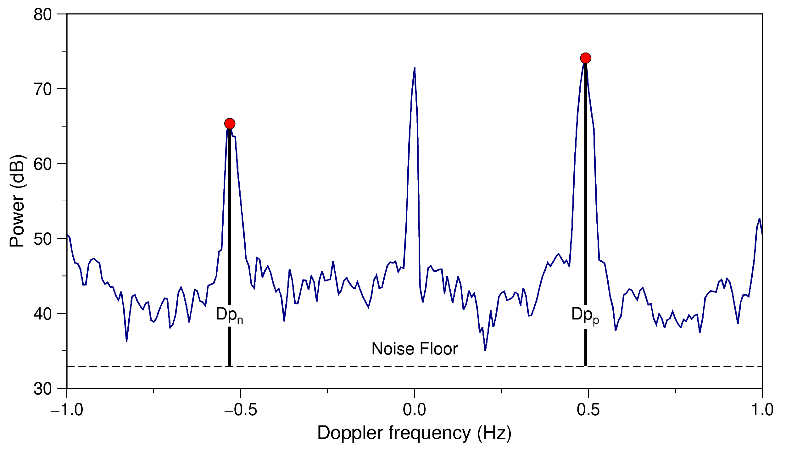
To validate this approach, the radar observation point nearest to St.1, i.e. N1, with a range of 10.5 km and bearing at 209° clockwise from north (shown in Figure 1), were selected for obtaining the characteristics. There was a distance of approximately 600 m between these observation points. We considered the received power in Equation (15) to be a sum of the scattering peak values for both negative and positive frequency regions D p n and D p p , respectively, as shown in Figure 4. The noise floor was calculated by averaging the Doppler spectra excluding approximately 0 Hz and first-order peak regions at the point furthest away from the radar (N2 in Figure 1). This value was considered to be unaffected by any ocean waves due to being buried by noise.

2.4. Calculation of the Effect of Wave Spectra and Electric Conductivity on Received Power

Before obtaining the reference values S 0 and Z 0 used in Equation (15), it was necessary to understand how these elements influenced the received power. These relationships were empirically determined, and an approximate expression was derived.

2.4.1. Wave Spectra

The relationship between Doppler and ocean wave spectra has been described in previous studies (e.g., [33,37]). Considering the enclosed nature of Ise Bay and the narrow mouth of the bay, it is reasonable to assume that the waves observed in the study area were primarily caused by wind. Therefore, wind and radar received power were used to estimate ocean wave spectra. In this case, the received power would approach negative infinity when the wind speed is 0 m/s because it can be assumed that no waves are generated under the condition of no wind. This characteristic can be represented by a logarithmic function and is frequently used to describe the relationship between wind waves and RCS by satellite microwave [38,39].
Ise Bay has two characteristic wind patterns: a northwesterly wind from fall to spring and a southerly wind in summer [40]. A similar trend was observed in 2016 shown in Figure 2d. The relationship between wind speed and received power must be distinguished based on these factors. Due to the difference in fetch at the observation point, ocean waves generated by these two wind types have different properties.
Figure 5 shows the relationship between the wind speed of the northerly 0 ° < θ 90 °   a n d   270 ° < θ 360 ° and southerly 90 ° < θ 270 ° winds and received power over the entire year in 2016 ( θ is the wind direction clockwise from north). To suppress the influence of SSS, we selected periods with an SSS of ≥ 25 psu, which are not considered to be affected by significant flooding. Received power from wave spectra usually increases with wind speed up to 5 m/s and subsequently becomes saturated after a certain level [41]. This tendency is confirmed in Figure 5b. However, the received power shown in Figure 5a reached the maximum with a wind speed of nearly 2 m/s, which contradicts the theory described above. It may have significantly impacted the fitting because it is inconsistent with the model represented by the logarithmic function. Therefore, we estimated the relational expression only from the southerly wind.

2.4.2. Electric Conductivity

Before calculating the relationship between Z and received power, the effect of wind was removed by the results of the previous section. A relationship was determined between receiving power and conductivity calculated from buoy SSS and SST data. A linear function was used for the approximate expression.

2.5. Determination of the Salinity Estimation Parameters

The data from May to July, during which southerly winds are frequently observed, were used to estimate the parameters. For the subsequent term from August to December, we estimated the SSS. In this term, the received power significantly declined following the decrease in SSS caused by flooding of the Kiso River in September, as shown in Figure 2a–c.
For the reference values S 0 and Z 0 , a wind speed of 5 m/s and conductivity of 4 S/m were selected. Reference power P 0 is the average of the received power (based on the condition above) when the wind speed is 5 m/s, and a conductivity of 4 ± 0.25 S/m was selected.
SSS was calculated by applying the SST value to conductivity according to the formula by UNESCO [42]. In this study, we used monthly SST data in Ise Bay based on a JCG report [30]. We set the SST uniformly at the upper (1.5–15 km) and lower (>15 km) parts of the bay, as shown in Table 2.

3. Results

3.1. Parameter Setup

Figure 6a shows the relationship between the received power and wind speed (southward) from May to July 2016. A solid line represents the least-squares approximation using a logarithmic function. The obtained formula is as follows:
P = 7.9 log 10 U + 69.8 ,
where U is the wind speed. The intercept in this equation is considered a term related to A , X , D , and B in Equation (12), which is unaffected by wind speed. These terms cancel out when calculating Δ S . The received power tended to decrease gradually when the wind speed was <3 m/s. The approximation formula expresses the general trend in this relationship.
Figure 6b shows the relationship between the conductivity and received power. The influence of wind speed on the received power was removed using Equation (16). The solid line was fitted with a straight line using the least-squares method. The obtained formula was as follows:
P = 11.57 σ 46.2 .
The correlation coefficient of the linear approximation was 0.6 and the standard deviation was 5.9. In Equation (17), the first term on the right-hand side corresponds to Z introduced in Equation (15). The intercept is a term related to S and B , which could not be eliminated by Equation (16).
Summarizing the above results, Δ P in Equation (15) was expressed as follows:
Δ P = 7.9 log 10 U 1 log 10 U 0 + 11.57 Δ σ .
Note that because water quality changes are not affected by the development of wind waves, the second term on the right is valid regardless of wind state. Next, we estimated the SSS using this equation.

3.2. SSS Estimates

3.2.1. Comparison with In Situ Observations

Figure 7 shows each value presented in Figure 2 from August to October. In this term, southerly winds blew mainly until early October. Figure 7 also includes the received power with a 25-h gaussian window moving average ( P 25 h in Figure 7a) and radar-estimated SSS from both the non-averaged received power P 1 h and P 25 h (in Figure 7c). Linear interpolation was performed for missing values. P 25 h can be considered a daily average. To estimate the SSS, the wind data at St.1 were used to remove the effect of wave spectra S . In Figure 7a, P 1 h displays high-frequency fluctuations compared to SSS while P 25 h displays reduced fluctuations. Although the moving average reduced the tide effect on the received power, river discharge was considered to affect SSS on a much longer time scale than tide changes. Thus, this timescale is a sufficiently practical index. In Ise Bay, the freshwater plume is exposed for approximately 36.5 d due to river discharge [43].
During the period of 19–24 September, a large amount of water was discharged from the Kiso River due to the approach of Typhoon Malakas [44]. During this period, the SSS (red line in Figure 7c) decreased to approximately 3–5 psu. In the second half of October, the SSS returned to approximately 30 psu following several discharge events. Throughout the period, the SSS ranged from 25 to 30 psu except in the flood season in September and October. In addition, the received power (Figure 7a) showed a similar trend; it decreased by approximately 40 dB after discharge.
Figure 7c displays the radar-estimated SSS results from P 1 h and P 25 h as gray lines and blue crosses, respectively, and from in situ observations (red lines). Both results showed synchronous changes in the SSS with the in situ observations, even with the large and abrupt discharge from the Kiso River brought about by the approaching typhoon.
Scatter plots comparing in situ observations and estimations of SSS by P 1 h and P 25 h are presented in Figure 8a,b, respectively, which show the range of SSS from 0 to 40 psu, and the color represents the wind speed. For data without a moving average, P 1 h , the correlation coefficient was 0.77 and root mean square error (RMSE) was 4.42 psu. The points plotted in the area below and above the 1:1 line indicate that the SSS is underestimated and overestimated, respectively. For P 25 h , the correlation coefficient and RMSE improved to 0.85 and 3.32 psu, respectively.
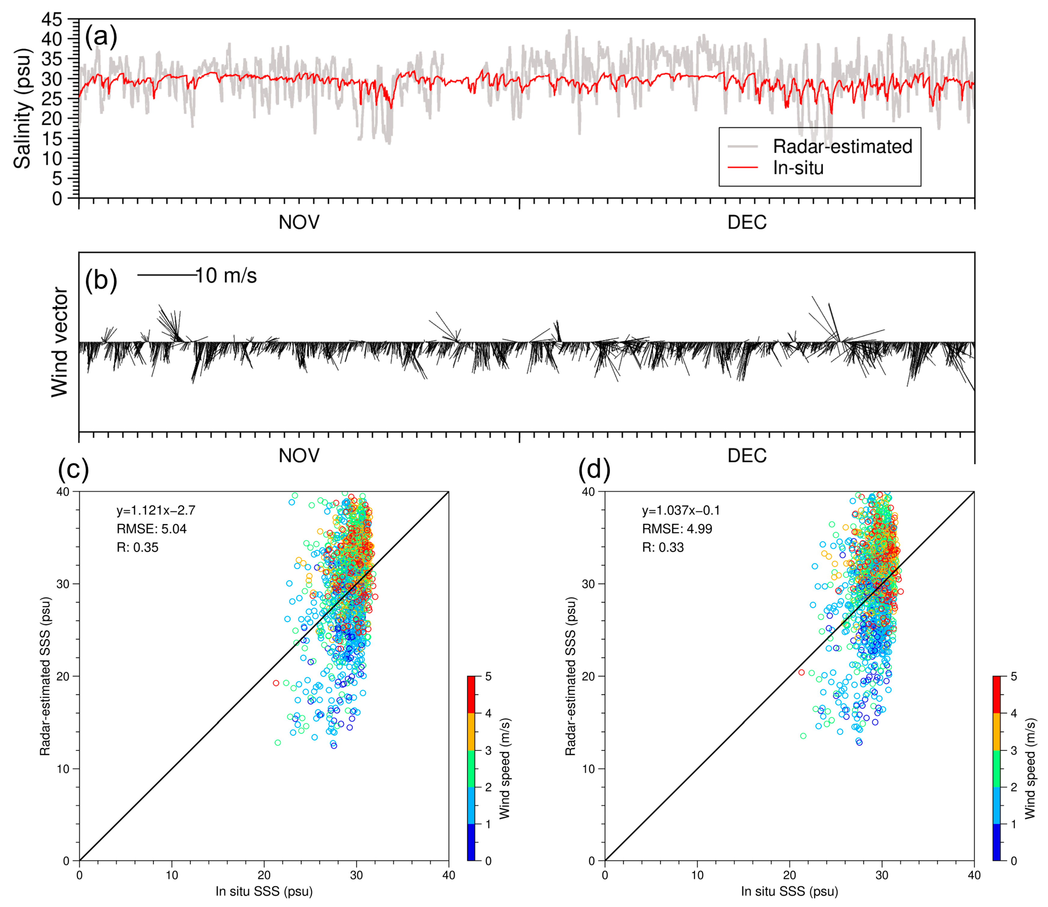
Figure 9a and b show a time series of the radar-estimated SSS by P 1 h and in situ observations of SSS and wind from November to December, during which period the wind was almost northerly. Thus, we did not remove the effect of the wave spectrum S because it was difficult to derive the relational expression between wind speed and received power under the northerly wind pattern, as described in Section 2.4.1. Based on a comparison with Figure 8a, the scatter plot of this condition (Figure 9c) shows an increase in errors (RMSE of 5.04 psu) and a clear error trend that was derived from the wind speed. The radar-estimated SSS was underestimated only when the wind speed was less than approximately 2 m/s; otherwise, it was overestimated because the received power varied greatly under the northerly wind pattern as shown in Figure 5a and attenuated more rapidly compared to that under a southerly wind pattern when the wind speed decreased.
We also estimated SSS by using the in situ SST obtained by the buoy at St.1 from November to December instead of the SST from the survey vessel (Table 2). The scatter plot (Figure 9d) showed that the RMSE was 4.99 psu, very similar to the result shown in Figure 9c. This indicated that SSS estimates were notably more affected by wind than SST in this study.

3.2.2. Distribution of Sea Surface Salinity

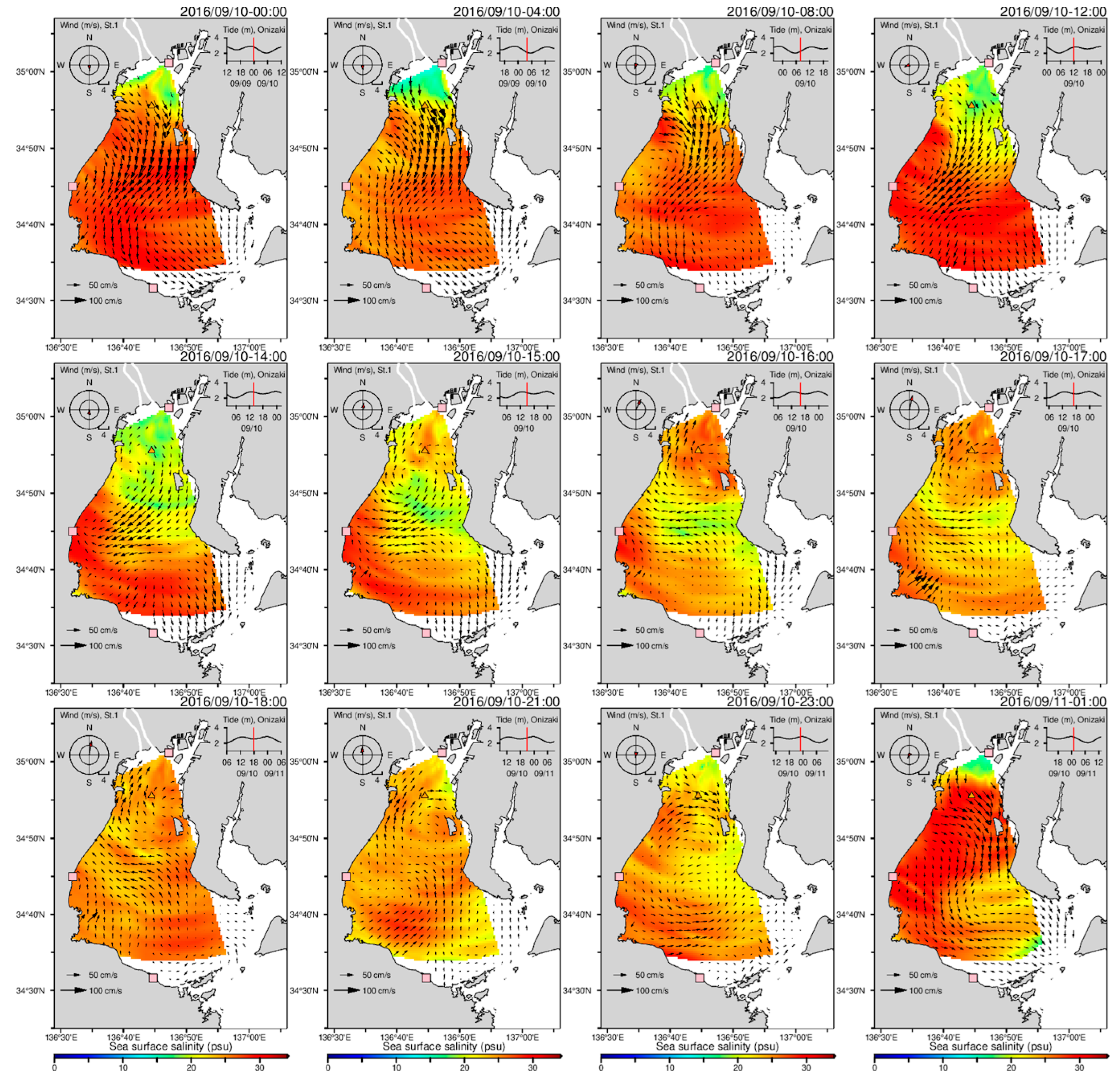
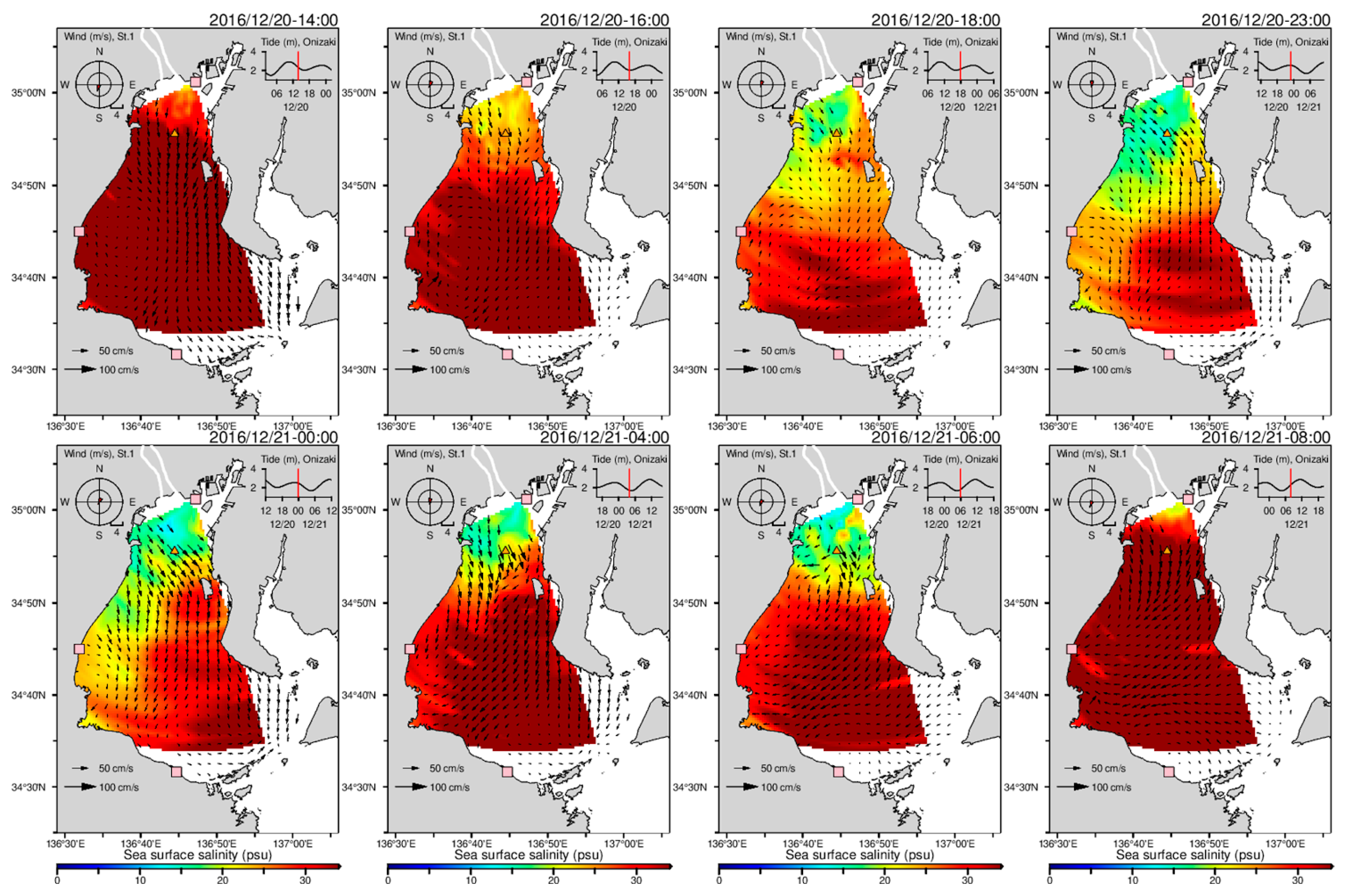
Freshwater discharge flowing into the bay was minimal in winter and maximal in summer. The SSS of the bay was greater in winter than in summer. Figure 10 and Figure 11 show the SSS distribution and sea surface current in the bay during neap tide in September and December, respectively. The wind speed and direction at St.1 and the tide level observed at Onizaki are also shown in Figure 10 and Figure 11. During neap tide, the flow field attributed to density currents appeared more prominently than that attributed to the tidal current. As shown in Figure 10, during 0:00–14:00 on 10 September, a meandering southwesterly current was observed from the northeast to southwest of the central part of the bay. Due to this flow, a low-salinity layer of approximately 15 psu spread to the central part of the bay. This flow then formed a clockwise circulating flow at the head of the bay (16:00 on 10 September). This clockwise circulating flow is often seen throughout the year [45,46]. In the south of the bay, a counterclockwise circulating current developed at around 21:00. This led to a flow that enveloped the low-salinity water slightly south of the center of the bay (23:00 on 10 September), thus forming a clear salinity front (1:00 on 11 September). In winter (Figure 11), the river plume spread from the head of the bay and moved southward along the western side of the bay. This propagation of a low-salinity mass in the winter was previously reported by Fujiwara [46]. As the tide rose, >30 psu of SSS uniformly covered the entire bay. A distinct salinity front was also seen during this process (0:00 and 4:00 on 21 December).
Figure 12 shows the massive discharge from the Kiso Three Rivers due to the effect of the typhoon. The discharge from the river into the bay began around 19 September. As missing data and noise occurred during this term, we provide snapshots that represent characteristics of the SSS and velocity field. Unlike the other discharge events shown above, a very-low-salinity water mass of <10 psu appeared at the head of the bay and moved southward from the head of the bay along the west sides of the bay with the ebbing tide (9:00–12:00 on 19 September). Similar behavior of the low-salinity mass discharged from the Kiso Three Rivers due to heavy rain was reported by Murakami et al. [47]. The SSS of the entire bay increased again with the subsequent high tide (21:00 on 19 September), as seen in Figure 7c. The river then discharged again (22:00 on 20 September). As a result, a very-low-salinity layer existed not only at the head of the bay but also in the center of the bay. This layer at the head of the bay was evident for several days. This result was also confirmed in the time series of St.1, as shown in Figure 7b,c. Since the large discharge from the Kiso Three Rivers forms a complex three-dimensional flow and density structures in the entire bay [47], it is difficult to describe the details based only on the SSS and sea surface velocity. Nevertheless, the SSS distribution calculated here was consistent with the velocity field and previous reports.

4. Discussion

This study presented and verified a method for estimating SSS based on Equation (15). Accurately estimating SSS requires an accurate estimation of the influence of the ocean wave spectrum and SSS on the received power.
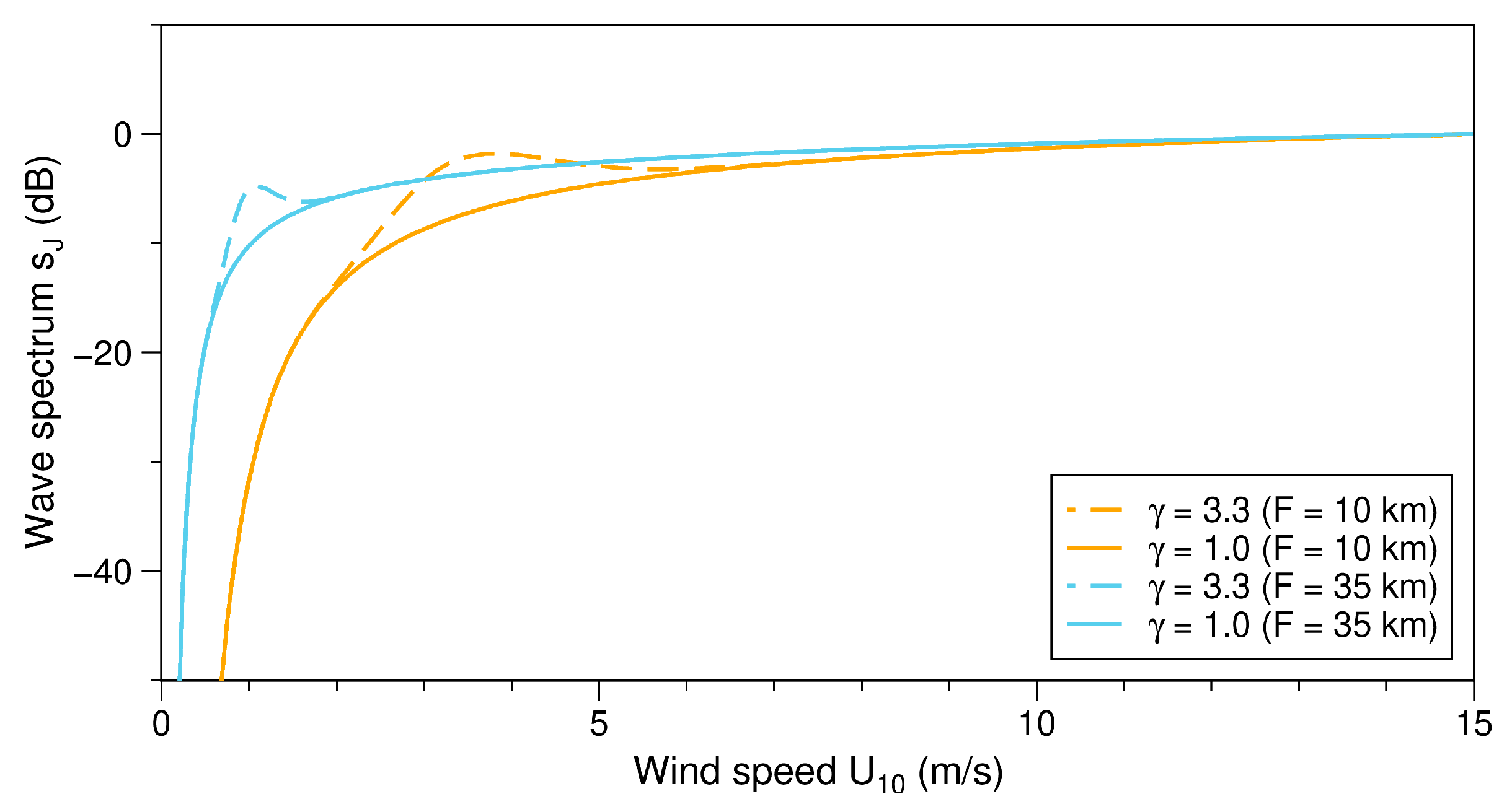
To estimate the wave spectrum, we calculated an empirical formula of Equation (16) using only southerly winds. We observed a dominant peak of approximately 2 m/s for wind speed in the northerly wind (Figure 5a), which was slightly visible in the southerly wind (Figure 5b). Due to the use of logarithmic functions as empirical formulas, these features were not reproduced. Wind direction plays a significant role in the development of sea waves, particularly in closed sea areas that have limited fetch, such as the inner part of Ise Bay. As shown below, the Joint North Sea Wave Project (JONSWAP) spectrum [48] can be used to represent sea states that are not completely developed in the fetch-limited sea area:
s J f w = α g 2 2 π 4 f w 5 exp 5 4 f w f w p 4 γ exp f w f w p 2 2 σ j 2 f w p 2 ,
where
α = 0.076 U 10 2 g F 0.22 ,
f w p = 3.5 g 2 U 10 F 0.33 ,   and
σ j = 0.07 f w f w p 0.09 f w > f w p ,
where f w is the wave frequency, f w p is the peak wave frequency, g is the gravitational acceleration, U 10 is the wind speed at a height of 10 m above the sea surface, F is the fetch length, and γ is the peak enhancement parameter that is introduced to represent fetch-limited wind at sea (normally set for γ = 3.3 ). When γ = 1 , the shape of the JONSWAP spectrum corresponds to the Pierson–Moskowitz spectrum [49] of a fully developed spectrum. Figure 13 shows the wave spectrum of the ocean waves ( f w = 0.505 [Hz] observed by 24.5 MHz HF radar) using γ of 3.3 and 1.0 calculated by Equations (19)–(22). The fetches F were set to 10 km and 35 km, corresponding to the fetch for northerly and southerly wind at St.1, respectively. The wave spectra were normalized to a value of 15 m/s for each spectrum. For γ = 3.3 , spectral peaks were seen for each fetch at lower wind speeds before the wave spectrum saturated, compared to γ = 1 . When the fetch was 10 km with γ = 3.3 (dashed orange line in Figure 13), the wave spectrum reached almost a maximum at wind speeds of 3–4 m/s. This spectral shape was obvious in Figure 5a, indicating that the ocean waves generated by northerly winds at St.1 were substantially affected by the fetch limitation. The spectral shape of the 35-km fetch length at γ = 3.3 (dashed blue line in Figure 13) was consistent with the shape of the received power under southerly winds in Figure 5b to some extent and was less affected by the limited fetch. Although the spectral model was not perfectly consistent with the observations, this finding qualitatively explained the observed results. In this study, the logarithmic function was used for approximation; however, an alternative empirical model has also been proposed (e.g., [50,51]). The accuracy of the SSS estimation may be improved using an appropriate approximation formula for the wave spectrum and subdividing the wind direction more finely. However, compared to offshore wind conditions, coastal wind conditions change rapidly and strongly depend on the local topography, which increases the difficulty of developing an accurate model.
The fundamental essence of SSS estimates using the HF radar is the relationship between the received power and conductivity, as shown in Figure 6b. Here, we expressed this as a linear function approximation that represents the attenuation of radio waves and reduction of the scattering cross section due to electrical conductivity. As shown in Equations (6–10), the attenuation of radio waves varied with the frequency (or wavelength) of radio waves. A number of frequency bands in the range of 3–50 MHz are allocated to be used for oceanographic radar applications as outlined in Resolution 612 in the 2012 World Radiocommunication Conference (WRC-12) [52]. Figure 14 shows the value of the attenuation coefficient A 4 for frequencies of 3 MHz, 10 MHz, 25 MHz, and 50 MHz at 10 km from the radar, as obtained by Equations (6–10). The attenuation values were normalized to a value of 4 S/m for each frequency. Figure 14 shows that higher frequencies were more susceptible to attenuation; in other words, they tended to be more sensitive to changes in electrical conductivity. At this distance (10 km from the radar), a radio wave of 3 MHz had almost no attenuation, when compared to other frequencies. This fact suggested that a radar operated with higher frequency is more suitable for SSS observations in terms of radio wave attenuation. However, the attenuation of ground-waves limits the observation range [17]. At least in the present study, the behavior of the SSS distribution in the enclosed coastal area of approximately 50 km long was well demonstrated by the 24.5 MHz HF radar.
We used a phased-array radar in this study, and the received power (Doppler spectra) was obtained following beam direction separation by DBF. Therefore, it is challenging to apply this method to the Doppler spectra, which is not separated by beam directions, such as those obtained by a compact-array radar (CODAR SeaSonde, CODAR Ocean Sensors Ltd, Mountain View, CA, USA.). However, as mentioned by Halverson et al. [20], the working range (i.e., distance to the farthest radial velocity solution) of the 25 MHz CODAR SeaSonde also increased approximately linearly with conductivity. Therefore, by using the working range instead of the received power, it may be possible to apply the method used in this study to a compact-array radar.
Because a numerical model was not used for verification, it was difficult to describe the accuracy of the distribution of SSS in detail. Since the wave spectrum S was not considered when estimating the SSS distribution, the estimated results were affected by errors introduced by wind. In addition, SST may have introduced errors. Nevertheless, the obtained salinity map clarified the behavior of the river plume in the bay, and the results were consistent with the surface current velocity behavior and previous studies. Further improvements in estimation accuracy can be expected if the wind and SST can be replaced with existing observations, such as land observation along coasts, satellite observations, and survey ship observations. The RMSEs of the SSS estimation varied based on the wind conditions, with values of 4.42–5.04 psu for 1-h radar data and 3.32 psu for 25-h averaged data. Thus, the HF radar is considered to be sufficiently applicable in enclosed coastal areas such as Ise Bay, where SSS decreases by >10 psu due to river flooding. In coastal areas, salinity may be mixed horizontally and vertically because of estuary circulation [45,46]; however, the HF radar is capable of observing only surface horizontal phenomena. By using numerical models together with HF radars, a better understanding of physical and environmental phenomena in coastal areas may be derived.

5. Conclusions

We presented a practical SSS estimation method using the HF radar and showed that the HF radar is appropriate for performing coastal salinity observations. First, we analyzed the relationships among the received power of the 24.5 MHz HF radar, electric conductivity, and wave spectrum and estimated SSS based on previously published methods. We showed the behavior of the river plume in the bay through the radar-estimated salinity distribution, and the results were consistent with the surface current velocity and previous research. Finally, we showed the applicability of this method at different operating frequencies and for a compact-array radar, which differs from the phased-array radar used in this study.
The HF radar has a notably higher temporal and spatial resolution than other remote sensing tools, such as satellite observations. Quantitative observations of fresh river plumes based on SSS and sea surface velocity using HF radars can provide a better understanding of the physical and environmental phenomena in coastal ecosystems that are greatly affected by the flow structure and ecosystem of river water.

Author Contributions

Conceptualization, Y.T. and S.F.; methodology, Y.T. and S.F.; software, Y.T.; validation, Y.T.; formal analysis, Y.T.; investigation, Y.T. and S.F.; resources, Y.T. and S.F.; data curation, Y.T.; writing—original draft preparation, Y.T.; writing—review and editing, Y.T. and S.F.; visualization, Y.T.; supervision, S.F.; project administration, S.F.; funding acquisition, S.F. All authors have read and agreed to the published version of the manuscript.

Funding

This research received no external funding.

Data Availability Statement

The radar spectral data from NABE were provided by the Chubu Regional Development Bureau, Ministry of Land, Infrastructure, Transport and Tourism, Japan (MILT). Tidal gauge data at Onizaki were obtained from the Geospatial Information Authority of Japan. SSS, SST, and wind data were obtained from the Isewan Environmental Database. The river flooding data were obtained from the Water Information System. The monthly SST data were obtained from Environmental Conservation Survey Results in Ise Bay.

Acknowledgments

We are grateful to the Chubu Regional Development Bureau, Ministry of Land, Infrastructure, Transport and Tourism, Japan for providing the radar spectral data.

Conflicts of Interest

The authors declare no conflict of interest.

References

  1. Fujii, S.; Heron, M.L.; Kim, K.; Lai, J.-W.; Lee, S.-H.; Wu, X.; Wu, X.; Wyatt, L.R.; Yang, W.-C. An overview of developments and applications of oceanographic radar networks in Asia and Oceania countries. Ocean Sci. J. 2013, 48, 69–97. [Google Scholar] [CrossRef]
  2. Rubio, A.; Mader, J.; Corgnati, L.; Mantovani, C.; Griffa, A.; Novellino, A.; Quentin, C.; Wyatt, L.; Schulz-Stellenfleth, J.; Horstmann, J.; et al. HF radar activity in European coastal seas: Next steps toward a pan-European HF radar network. Front. Mar. Sci. 2017, 4, 8. [Google Scholar] [CrossRef] [Green Version]
  3. Roarty, H.; Cook, T.; Hazard, L.; George, D.; Harlan, J.; Cosoli, S.; Wyatt, L.; Fanjul, E.A.; Terrill, E.; Otero, M.; et al. The global high frequency radar network. Front. Mar. Sci. 2019, 6, 164. [Google Scholar] [CrossRef]
  4. Lorente, P.; Aguiar, E.; Bendoni, M.; Berta, M.; Brandini, C.; Cáceres-Euse, A.; Capodici, F.; Cianelli, D.; Ciraolo, G.; Corgnati, L.; et al. Coastal high-frequency radars in the Mediterranean—Part 1: Status of operations and a framework for future development. Ocean Sci. 2022, 18, 761–795. [Google Scholar] [CrossRef]
  5. Lipa, B.; Barrick, D.; Saitoh, S.-I.; Ishikawa, Y.; Awaji, T.; Largier, J.; Garfield, N. Japan tsunami current flows observed by HF radars on two continents. Remote Sens. 2011, 3, 1663–1679. [Google Scholar] [CrossRef] [Green Version]
  6. Fuji, R.; Hinata, H. Temporal variability of tsunami arrival detection distance revealed by virtual tsunami observation experiments using numerical simulation and 1-month HF radar observation. J. Oceanogr. 2017, 73, 725–741. [Google Scholar] [CrossRef]
  7. Grilli, S.T.; Grosdidier, S.; Guérin, C.A. Tsunami detection by high-frequency radar beyond the continental shelf: I: Algorithms and validation on idealized case studies. Pure Appl. Geophys. 2016, 173, 3895–3934. [Google Scholar] [CrossRef]
  8. Hinata, H.; Fujii, S.; Furukawa, K.; Kataoka, T.; Miyata, M.; Kobayashi, T.; Mizutani, M.; Kokai, T.; Kanatsu, N. Propagating tsunami wave and subsequent resonant response signals detected by HF radar in the Kii Channel, Japan. Estuar. Coast. Shelf Sci. 2011, 95, 268–273. [Google Scholar] [CrossRef]
  9. Toguchi, Y.; Fujii, S.; Hinata, H. Tsunami waves and tsunami-induced natural oscillations determined by HF radar in Ise Bay, Japan. J. Geophys. Res. Ocean. 2018, 123, 2965–2980. [Google Scholar] [CrossRef]
  10. Wyatt, L.R. A relaxation method for integral inversion applied to HF radar measurement of the ocean wave directional spectrum. Int. J. Remote Sens. 1990, 11, 1481–1494. [Google Scholar] [CrossRef]
  11. Gurgel, K.-W.; Essen, H.-H.; Schlick, T. An empirical method to derive ocean waves from second-order Bragg scattering: Prospects and limitations. IEEE J. Ocean. Eng. 2006, 31, 804–811. [Google Scholar] [CrossRef]
  12. Basañez, A.; Lorente, P.; Montero, P.; Álvarez-Fanjul, E.; Pérez-Muñuzuri, V. Quality assessment and practical interpretation of the wave parameters estimated by HF radars in NW Spain. Remote Sens. 2020, 12, 598. [Google Scholar] [CrossRef] [Green Version]
  13. Heron, M.; Rose, R. On the application of HF ocean radar to the observation of temporal and spatial changes in wind direction. IEEE J. Ocean. Eng. 1986, 11, 210–218. [Google Scholar] [CrossRef]
  14. Shen, W.; Gurgel, K.-W.; Voulgaris, G.; Schlick, T.; Stammer, D. Wind-speed inversion from HF radar first-order backscatter signal. Ocean Dyn. 2012, 62, 105–121. [Google Scholar] [CrossRef]
  15. Wyatt, L.R. Progress towards an HF radar wind speed measurement method using machine learning. Remote Sens. 2022, 14, 2098. [Google Scholar] [CrossRef]
  16. Meadows, L.A.; Whelan, C.; Barrick, D.; Kroodsma, R.; Ruf, C.; Teague, C.C.; Meadows, G.A.; Wang, S. High frequency radar and its application to fresh water. J. Great Lakes Res. 2013, 39, 183–193. [Google Scholar] [CrossRef]
  17. Gurgel, K.-W.; Essen, H.-H.; Kingsley, S. High-frequency radars: Physical limitations and recent developments. Coast. Eng. 1999, 37, 201–218. [Google Scholar] [CrossRef]
  18. Fernandez, D.M.; Meadows, L.A.; Vesecky, J.F.; Teague, C.C.; Paduan, J.D.; Hansen, P. Surface current measurements by HF radar in freshwater lakes. IEEE J. Ocean. Eng. 2000, 25, 458–471. [Google Scholar] [CrossRef]
  19. Diercks, A.R.; Howden, S.D.; Barrick, D. HF Radar Signal Propagation as a Function of Salinity—A Case Study in the Mississippi Sound. In Proceedings of the AGU Fall Meeting Abstracts, San Francisco, CA, USA, 1 December 2016; Volume 2016, pp. OS13B–1825. [Google Scholar]
  20. Halverson, M.; Pawlowicz, R.; Chavanne, C. Dependence of 25-Mhz HF radar working range on near-surface conductivity, sea state, and tides. J. Atmos. Ocean. Technol. 2017, 34, 447–462. [Google Scholar] [CrossRef]
  21. Tarantolo, P.J. Electromagnetic Probing of Salt with High Frequency Radar. Ph.D. Thesis, Texas A&M University, College Station, TX, USA, 1978. [Google Scholar]
  22. Yoshii, T. Measuring Sea Surface Salinity and Sea Surface Temperature Using Ocean Radar; Central Research Institute of Electric Power, Environmental Science Research Laboratory, Rep. No. V09038. 2010. Available online: https://criepi.denken.or.jp/hokokusho/pb/reportDetail?reportNoUkCode=V09038 (accessed on 14 March 2023).
  23. Yoshii, T.; Sakai, S.; Tsubono, T.; Matsuyama, M.; Tada, A.; Nakamura, T. Consideration of impact factors on data acquisition for ocean radar with VHF band. In Proceedings of the 2008 International Conference on Radar, Adelaide, Australia, 2–5 September 2008; IEEE: San Francisco, CA, USA, 2008; pp. 682–687. [Google Scholar]
  24. Font, J.; Camps, A.; Borges, A.; Martín-Neira, M.; Boutin, J.; Reul, N.; Kerr, Y.H.; Hahne, A.; Mecklenburg, S. SMOS: The challenging sea surface salinity measurement from space. Proc. IEEE 2010, 98, 649–665. [Google Scholar] [CrossRef] [Green Version]
  25. Kerr, Y.H.; Waldteufel, P.; Wigneron, J.-P.; Delwart, S.; Cabot, F.; Boutin, J.; Escorihuela, M.-J.; Font, J.; Reul, N.; Gruhier, C.; et al. The SMOS mission: New tool for monitoring key elements of the global water cycle. Proc. IEEE 2010, 98, 666–687. [Google Scholar] [CrossRef] [Green Version]
  26. Bai, Y.; Pan, D.; Cai, W.-J.; He, X.; Wang, D.; Tao, B.; Zhu, Q. Remote sensing of salinity from satellite-derived CDOM in the Changjiang River dominated East China Sea. J. Geophys. Res. Ocean. 2013, 118, 227–243. [Google Scholar] [CrossRef]
  27. Fujiwara, T.; Takahashi, T.; Kasai, A.; Sugiyama, Y.; Kuno, M. the role of circulation in the development of hypoxia in Ise Bay, Japan. Estuar. Coast. Shelf Sci. 2002, 54, 19–31. [Google Scholar] [CrossRef]
  28. Isewan Environmental Database. Available online: www.isewan-db.go.jp (accessed on 18 January 2023).
  29. Water Information System. Available online: http://www1.river.go.jp/ (accessed on 18 January 2023).
  30. Environmental Conservation Survey Results in Ise Bay. Available online: https://www1.kaiho.mlit.go.jp/KAN4/kaisyo/kasoho/kasoho.html (accessed on 14 March 2023).
  31. Barrick, D. First-order theory and analysis of MF/HF/VHF scatter from the sea. IEEE Trans. Antennas Propag. 1972, 20, 2–10. [Google Scholar] [CrossRef] [Green Version]
  32. Gurgel, K.-W.; Essen, H.-H.; Schlick, T. Tracking of fresh-water plumes in Dutch coastal waters by means of HF Radar. In Proceedings of the IEEE 1999 International Geoscience and Remote Sensing Symposium, IGARSS’99 (Cat. No.99CH36293), Hamburg, Germany, 28 June–2 July 1999; IEEE: Hamburg, Germany, 1999; Volume 5, pp. 2548–2550. [Google Scholar]
  33. Barrick, D.E. Theory of HF and VHF propagation across the rough sea, 1, the effective surface impedance for a slightly rough highly conducting medium at grazing incidence. Radio Sci. 1971, 6, 517–526. [Google Scholar] [CrossRef]
  34. Barrick, D.E.; Peake, W.H. A review of scattering from surfaces with different roughness scales. Radio Sci. 1968, 3, 865–868. [Google Scholar] [CrossRef]
  35. Guinard, N.W.; Ransone, J.T.; Daley, J.C. Variation of the NRCS of the sea with increasing roughness. J. Geophys. Res. 1971, 76, 1525–1538. [Google Scholar] [CrossRef]
  36. Knight, P.; Robson, J.A.W. Empirical formula for groundwave field-strength calculation. Electron. Lett. 1984, 20, 740. [Google Scholar] [CrossRef]
  37. Barrick, D.E.; Weber, B.L. On the nonlinear theory for gravity waves on the ocean’s surface. Part II: Interpretation and applications. J. Phys. Oceanogr. 1977, 7, 11–21. [Google Scholar] [CrossRef]
  38. Chelton, D.B.; McCabe, P.J. A review of satellite altimeter measurement of sea surface wind speed: With a proposed new algorithm. J. Geophys. Res. 1985, 90, 4707. [Google Scholar] [CrossRef]
  39. Schroeder, L.C.; Boggs, D.H.; Dome, G.; Halberstam, I.M.; Jones, W.L.; Pierson, W.J.; Wentz, F.J. The relationship between wind vector and normalized radar cross section used to derive SEASAT-A satellite scatterometer winds. J. Geophys. Res. 1982, 87, 3318. [Google Scholar] [CrossRef]
  40. Sekine, Y.; Nakamura, S. Variation in wind in the region around Ise Bay. Bull. Fac. Bioresour. 2002, 28, 1–9. [Google Scholar]
  41. Tian, Y.; Wen, B.; Zhou, H.; Wang, C.; Yang, J.; Huang, W. Wave height estimation from first-order backscatter of a dual-frequency high frequency radar. Remote Sens. 2017, 9, 1186. [Google Scholar] [CrossRef] [Green Version]
  42. Fofonoff, N.P.; Millard, R.C., Jr. Algorithms for the Computation of Fundamental Properties of Seawater; UNESCO Technical Papers in Marine Sciences; 44; UNESCO: Paris, France, 1983. [Google Scholar]
  43. Tanaka, Y.; Ikeda, K. Analyse of relationship between hypoxia and age in Ise Bay by using numerical simulation. J. Japan Soc. Civ. Eng. Ser. B2 2015, 71, I_1261–I_1266. [Google Scholar] [CrossRef]
  44. Annual Tropical Cyclone Report 2016. Available online: https://www.metoc.navy.mil/jtwc/products/atcr/2016atcr.pdf (accessed on 18 January 2023).
  45. Fujiwara, T.; Sanford, L.P.; Nakatsuji, K.; Sugiyama, Y. Anti-cyclonic circulation driven by the estuarine circulation in a gulf type ROFI. J. Mar. Syst. 1997, 12, 83–99. [Google Scholar] [CrossRef]
  46. Fujiwara, T. Buoyancy-driven current during cooling periods in Ise Bay, Japan. J. Geophys. Res. 2003, 108. [Google Scholar] [CrossRef]
  47. Murakami, T.; Kawasaki, K.; Okubo, Y.; Kim, J. Numerical analysis of flow and density structures in Ise Bay Area at Tokai Heavy Rain. Proc. Coast. Eng. JSCE 2007, 54, 371–375. [Google Scholar] [CrossRef]
  48. Hasselmann, K.; Barnett, T.P.; Bouws, E.; Carlson, H.; Cartwright, D.E.; Enke, K.; Ewing, J.A.; Gienapp, A.; Hasselmann, D.E.; Kruseman, P.; et al. Measurements of wind-wave growth and swell decay during the Joint North Sea Wave Project (JONSWAP). Ergänzungsh. zur Dtsch. Hydrogr. Zeitschrift, R.A. 1973, 12, 1–95. [Google Scholar]
  49. Pierson, W.J.; Moskowitz, L. A proposed spectral form for fully developed wind seas based on the similarity theory of S. A. Kitaigorodskii. J. Geophys. Res. 1964, 69, 5181–5190. [Google Scholar] [CrossRef]
  50. Zhou, H.; Wen, B. Wave height extraction from the first-order Bragg peaks in high-frequency radars. IEEE Geosci. Remote Sens. Lett. 2015, 12, 2296–2300. [Google Scholar] [CrossRef]
  51. Zhou, H.; Wang, C.; Yang, J.; Tian, Y.; Wen, B. Wind and current dependence of the first-order Bragg scattering power in high-frequency radar sea echoes. IEEE Geosci. Remote Sens. Lett. 2017, 14, 2428–2432. [Google Scholar] [CrossRef]
  52. International Telecommunication Union. Final Acts WRC-12, Resolution 612, Use of the radiolocation service between 3 and 50 MHz to support oceanographic radar operations. In Proceedings of the World Radiocommunication Conference, Geneva, Switzerland, 23 January–17 February 2012. [Google Scholar]
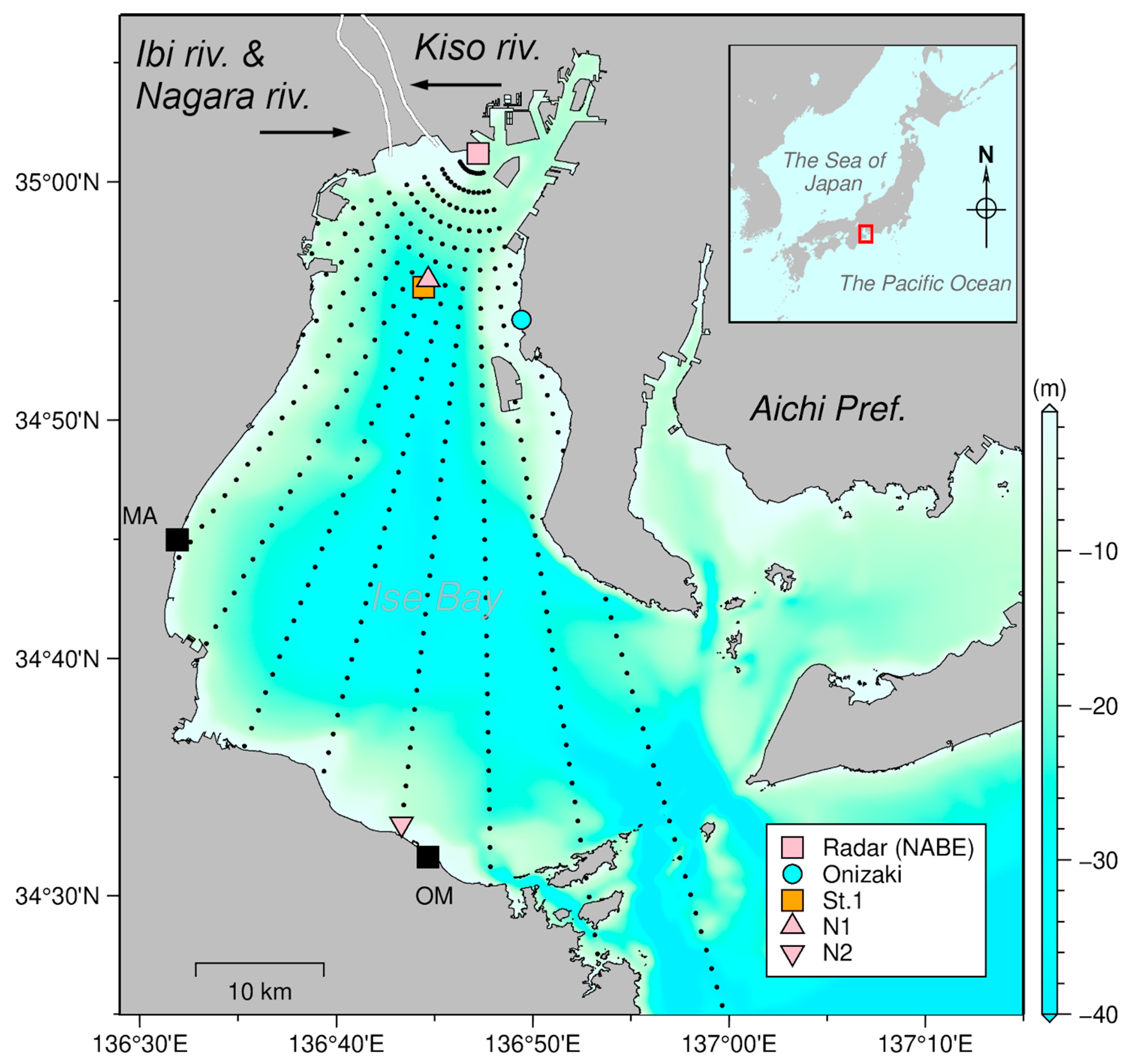
Figure 1. Study area of Ise Bay showing radar sites Nabeta (NABE, red square), Matsusaka, and Ominato (MA and OM respectively, black squares), tide gauge Onizaki (blue circle), in situ observation point St.1 (orange square), radar observation point nearest to St.1 (N1, red triangle), radar observation point for the noise floor (N2, inverted red triangle). The Kiso Three Rivers (Kiso, Ibi, and Nagara rivers) are shown by black arrows.
Remotesensing 15 03088 g001
Figure 2. Time series of (a) radar received power, (b) Kiso River flow rate, (c) sea surface salinity, and (d) wind forcing for 2016.
Remotesensing 15 03088 g002
Figure 3. (a,b) Relationship between attenuation factor A and distance R with conductivity as a parameter; (c,d) relationship between attenuation factor A and conductivity with distance as a parameter. A linear dotted line R 1 , which is inversely proportional to distance, is also shown in (a). (b,d) Results of subtracting R 1 from (a,c), respectively.
Remotesensing 15 03088 g003
Figure 4. Definition of received power, which was defined as the sum of the peak intensity values (the red dots indicate the peak points) for both negative ( D p n ) and positive ( D p p ) frequency regions.
Remotesensing 15 03088 g004
Figure 5. Relationship between wind speed of the (a) northerly 0 ° < θ 90 °   a n d   270 ° < θ 360 ° and (b) southerly 90 ° < θ 270 ° winds and received power in 2016. θ is the wind direction clockwise from north.
Remotesensing 15 03088 g005
Figure 6. Relationship between (a) wind speed and received power and (b) conductivity and received power.
Remotesensing 15 03088 g006
Figure 7. Time series of the (a) radar received power with non-average ( P 1 h , gray) and 25-h gaussian window moving average ( P 25 h , black), (b) flow rate of the Kiso River, (c) sea surface salinity (SSS) based on in situ observations (red) and radar estimates by P 1 h (gray) and P 25 h (blue cross), and (d) wind forcing.
Remotesensing 15 03088 g007
Figure 8. Comparing sea surface salinity (SSS) in situ observations with radar estimates by (a) P 1 h and (b) P 25 h . Different colors indicate wind speed.
Remotesensing 15 03088 g008
Figure 9. Time series of (a) sea surface salinity (SSS) and (b) wind. Scatter plot of the SSS comparing in situ observations with radar estimates using SST from (c) the survey vessel and (d) in situ observation at St.1. Different colors indicate wind speed.
Remotesensing 15 03088 g009
Figure 10. Radar-estimated sea surface salinity distribution and sea surface current field during neap tide in September. The wind at St.1 (top left) and the tide level observed at Onizaki (top right) are also shown.
Remotesensing 15 03088 g010
Figure 11. Radar-estimated sea surface salinity distribution and sea surface current field during neap tide in December. The wind at St.1 (top left) and the tide level observed at Onizaki (top right) are also shown.
Remotesensing 15 03088 g011
Figure 12. Radar-estimated sea surface salinity distribution and sea surface current field during the massive discharge from the Kiso Three Rivers in September. The wind at St.1 (top left) and the tide level observed at Onizaki (top right) are also shown.
Remotesensing 15 03088 g012
Figure 13. JONSWAP spectrum of an ocean wave (frequency of 0.505 [Hz]) with 10 km (orange) and 35 km (blue) fetch length.
Remotesensing 15 03088 g013
Figure 14. Relationship between attenuation factor A 4 and conductivity for 3, 10, 25, and 50 MHz radar frequencies.
Remotesensing 15 03088 g014
Table 1. System specifications of the high-frequency (HF) radar.
ParameterValue
Beam forming methodDigital beamforming (DBF)
Radar typeFrequency modulated interrupted continuous wave (FMICW)
Center frequency24.515 MHz
Sweep bandwidth100 kHz
Frequency sweep interval0.5 s
Maximum transmission power200 W
Range resolution1.5 km
Azimuth resolution7.5°
Antenna type1 transmission and 8 receiving antenna of 3-element Yagi
Data update cycle1 h
Table 2. Sea surface temperature (SST) obtained from a Japan Coast Guard report [30].
LocationSST (°C)
AUGSEPOCTNOVDEC
Upper part of the bay
(range 1.5–15 km)
27.527.521.518.514.0
Lower part of the bay
(range > 15 km)
27.527.022.518.514.0
Disclaimer/Publisher’s Note: The statements, opinions and data contained in all publications are solely those of the individual author(s) and contributor(s) and not of MDPI and/or the editor(s). MDPI and/or the editor(s) disclaim responsibility for any injury to people or property resulting from any ideas, methods, instructions or products referred to in the content.