Assessing the Performance of Multi-Resolution Satellite SAR Images for Post-Earthquake Damage Detection and Mapping Aimed at Emergency Response Management

 ,
, 
Abstract
1. Introduction
2. Materials and Methods
2.1. Spaceborne SAR Data
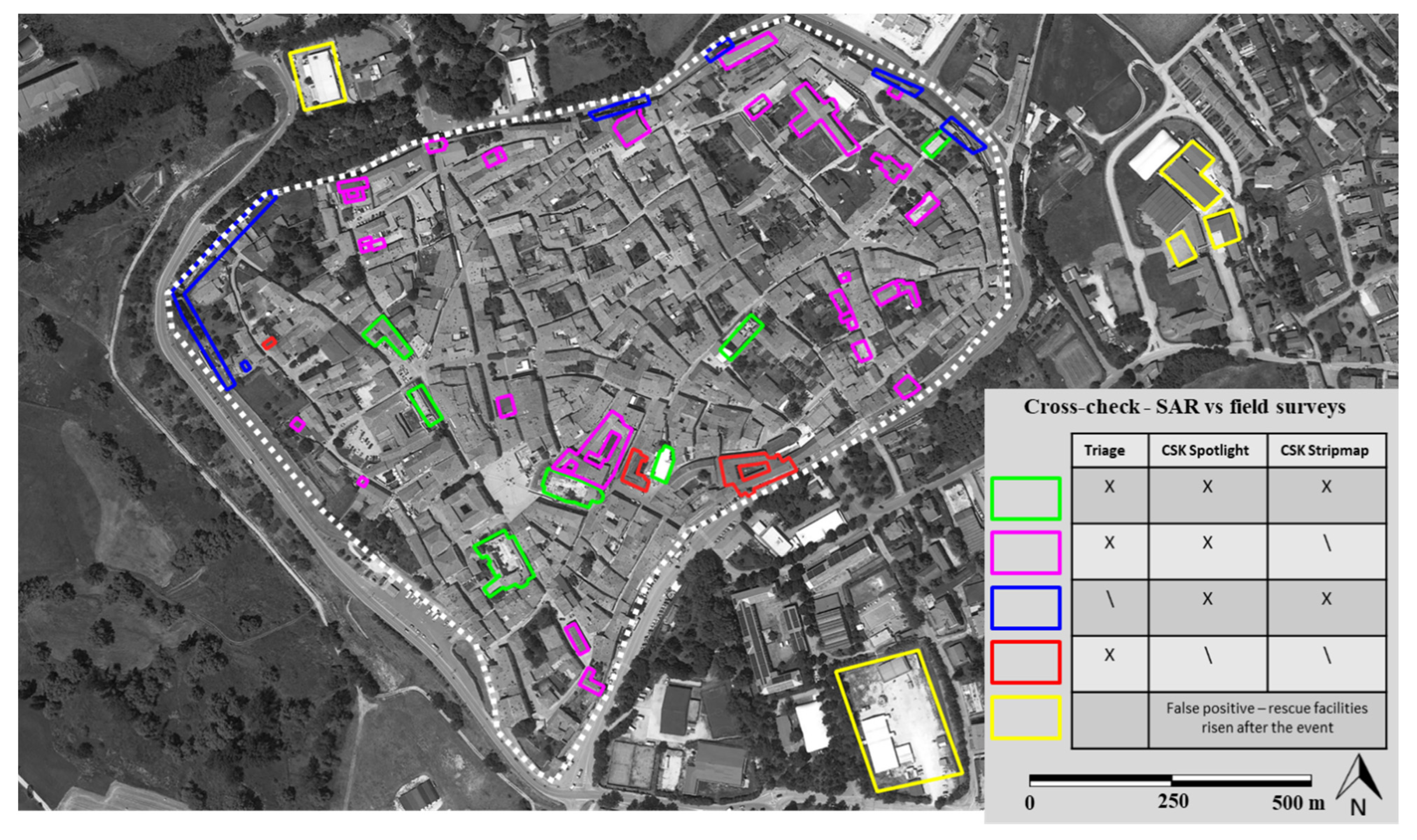
2.2. Field Survey Damage Mapping
2.3. IRIS Software
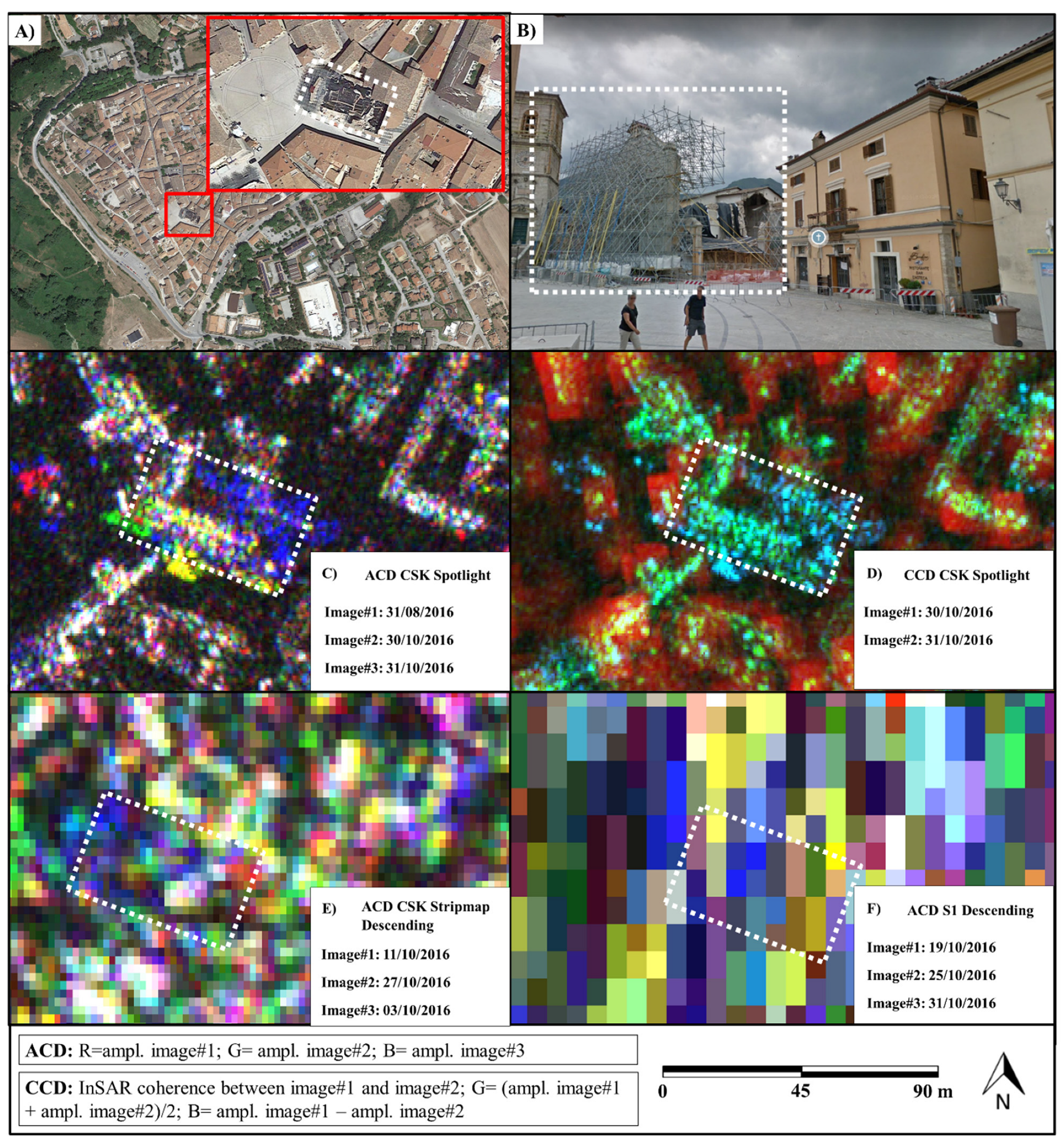
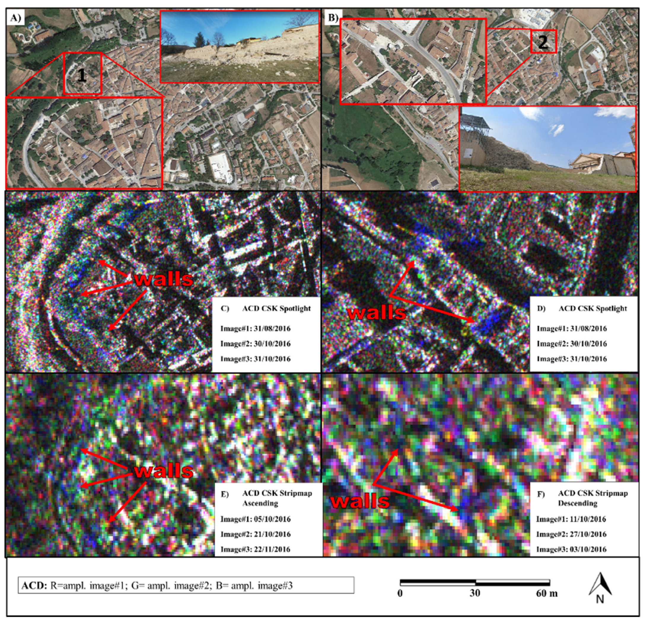
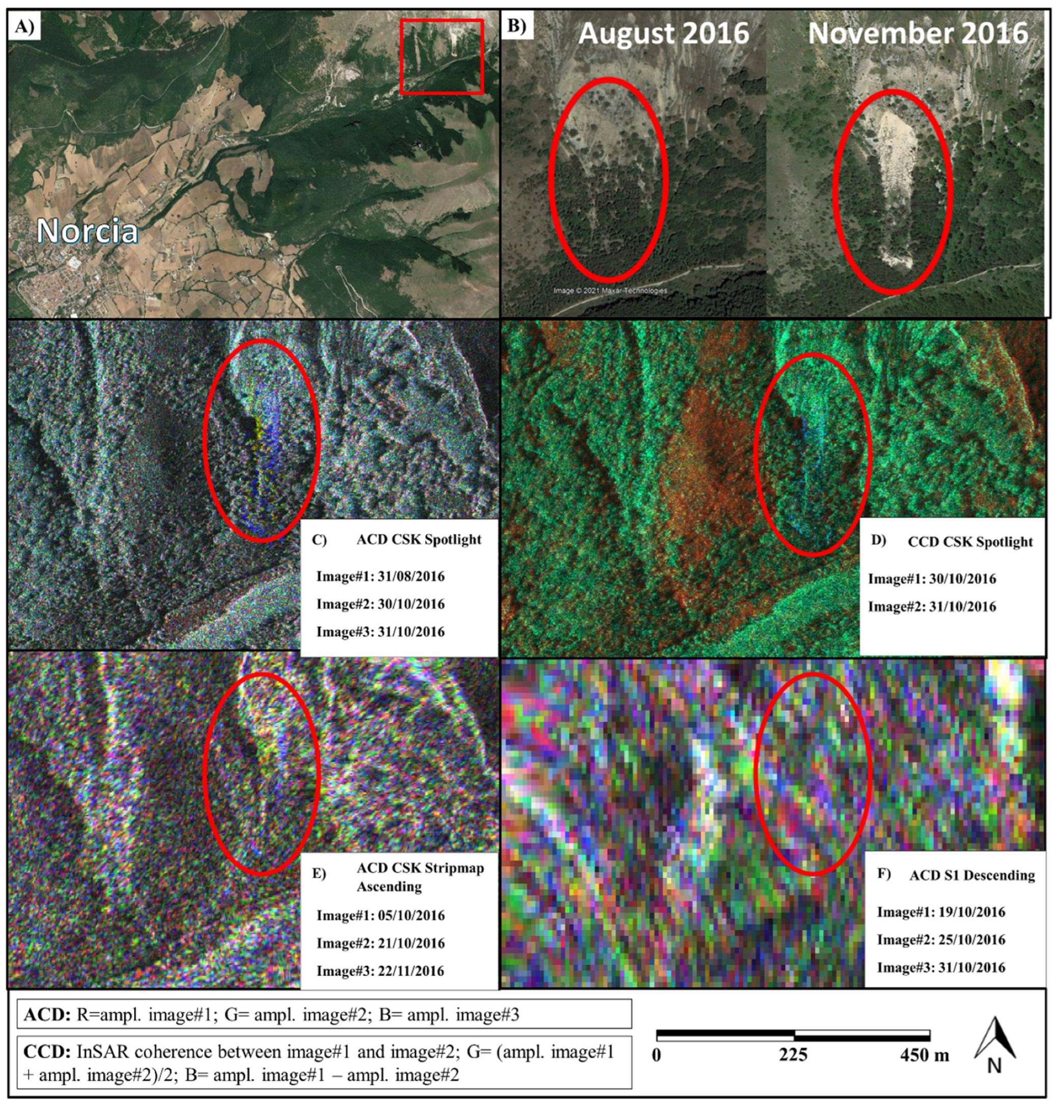
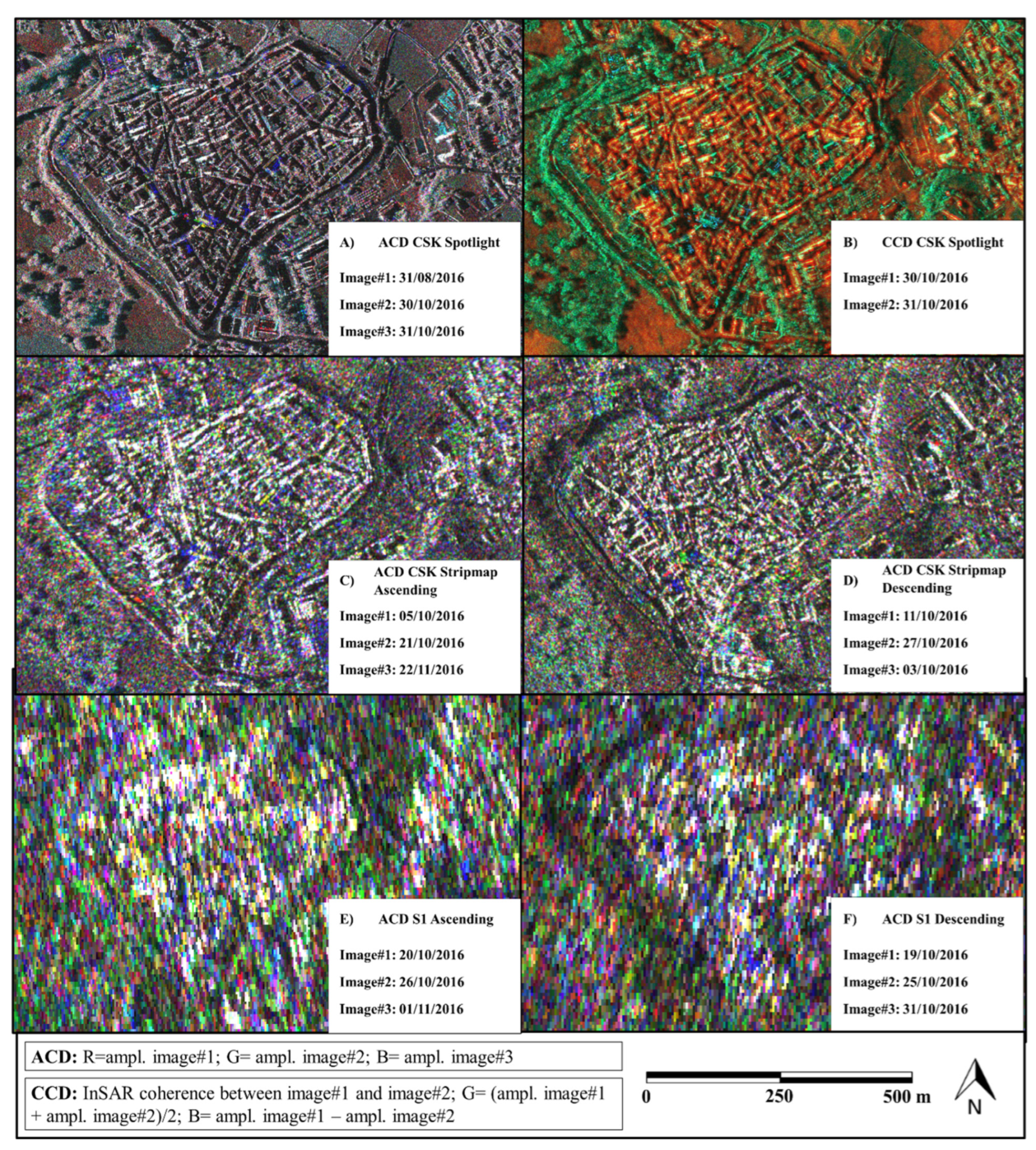
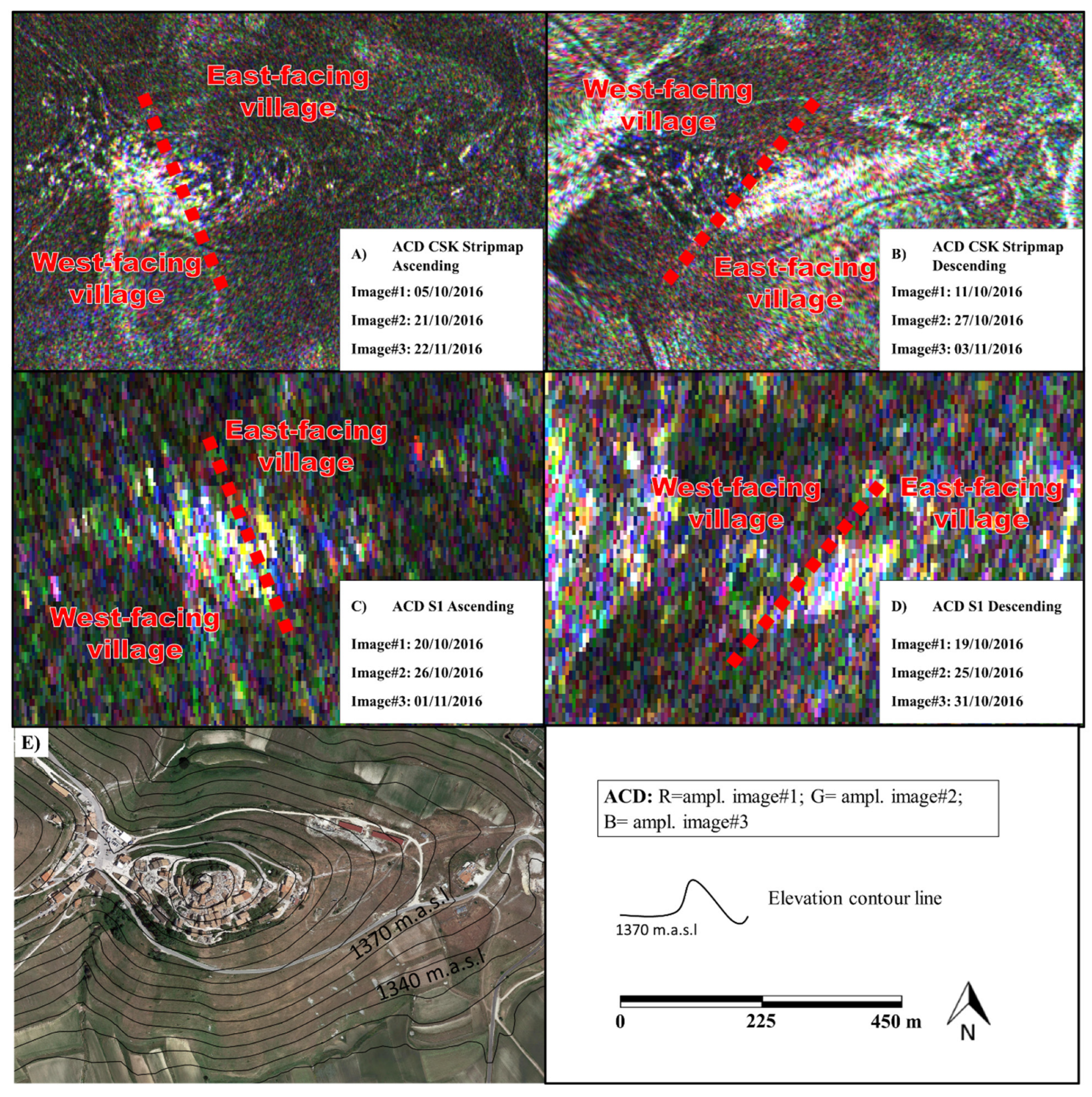
2.4. Amplitude and Coherent Change Detection
G = amplitude Image #2; [0–255]
B = amplitude Image #3. [0–255]
G = (amplitude Image#1 + amplitude Image#2)/2 [0–255]
B = amplitude Image#1—amplitude Image#2 [0–255]
3. Results
4. Discussions
5. Conclusions
Author Contributions
Funding
Acknowledgments
Conflicts of Interest
References
- Clement, M.A.; Kilsby, C.G.; Moore, P. Multi-temporal synthetic aperture radar flood mapping using change detection. J. Flood Risk Manag. 2018, 11, 152–168. [Google Scholar] [CrossRef] [Scilit]
- Jung, J.; Kim, D.J.; Lavalle, M.; Yun, S.H. Coherent change detection using InSAR temporal decorrelation model: A case study for volcanic ash detection. IEEE Trans. Geosci. Remote Sens. 2016, 54, 5765–5775. [Google Scholar] [CrossRef] [Scilit]
- Bovolo, F.; Marin, C.; Bruzzone, L. A novel approach to building change detection in very high-resolution SAR images. Image Signal Processing Remote Sens. XVIII 2012, 8537, 285–296. [Google Scholar] [CrossRef] [Scilit]
- Li, Q.; Gong, L.; Zhang, J. Earthquake-Induced Building Recognition Using Correlation Change Detection of Texture Features Based on SAR Data. Geod. List 2018, 72, 93–112. [Google Scholar]
- Miura, H.; Midorikawa, S.; Matsuoka, M. Building damage assessment using high-resolution satellite SAR images of the 2010 Haiti earthquake. Earthq. Spectra 2016, 32, 591–610. [Google Scholar] [CrossRef] [Scilit]
- Wieland, M.; Liu, W.; Yamazaki, F. Learning change from Synthetic Aperture Radar images: Performance evaluation of a Support Vector Machine to detect earthquake and tsunami-induced changes. Remote Sens. 2016, 8, 792. [Google Scholar] [CrossRef] [Scilit]
- Gamba, P.; Dell’Acqua, F.; Trianni, G. Rapid damage detection in the Bam area using multitemporal SAR and exploiting ancillary data. IEEE Trans. Geosci. Remote Sens. 2007, 45, 1582–1589. [Google Scholar] [CrossRef]
- Brunner, D.; Lemoine, G.; Bruzzone, L. Earthquake damage assessment of buildings using VHR optical and SAR imagery. IEEE Trans. Geosci. Remote Sens. 2010, 48, 2403–2420. [Google Scholar] [CrossRef] [Scilit]
- Ajadi, O.A.; Meyer, F.J.; Webley, P.W. Change detection in synthetic aperture radar images using a multiscale-driven approach. Remote Sens. 2016, 8, 482. [Google Scholar] [CrossRef] [Scilit]
- Luo, H.; Liu, C.; Wu, C.; Guo, X. Urban change detection based on Dempster–Shafer theory for multitemporal very high-resolution imagery. Remote Sens. 2018, 10, 980. [Google Scholar] [CrossRef] [Scilit]
- Saur, G.; Krüger, W. Change detection in UAV video mosaics combining a feature based approach and extended image differencing. In Proceedings of the International Archives of the Photogrammetry, Remote Sensing & Spatial Information Sciences, Prague, Czech Republic, 2–19 July 2016; Volume 41. [Google Scholar]
- Jung, J.; Yun, S.H. Evaluation of Coherent and Incoherent Landslide Detection Methods Based on Synthetic Aperture Radar for Rapid Response: A Case Study for the 2018 Hokkaido Landslides. Remote Sens. 2020, 12, 265. [Google Scholar] [CrossRef] [Scilit]
- Curlander, J.C.; McDonough, R.N. Synthetic Aperture Radar; Wiley: New York, NY, USA, 1991; Volume 11, ISBN 047185770X. [Google Scholar]
- Bovenga, F.; Belmonte, A.; Refice, A.; Pasquariello, G.; Nutricato, R.; Nitti, D.O.; Chiaradia, M.T. Performance analysis of satellite missions for multi-temporal SAR interferometry. Sensors 2018, 18, 1359. [Google Scholar] [CrossRef] [Scilit] [PubMed]
- Caltagirone, F.; Capuzi, A.; Coletta, A.; De Luca, G.F.; Scorzafava, E.; Leonardi, R.; Rivola, S.; Fagioli, S.; Angino, G.; L’Abbate, M.; et al. The COSMO-SkyMed dual use Earth observation program: Development, qualification, and results of the commissioning of the overall constellation. IEEE J. Sel. Top. Appl. Earth Obs. Remote Sens. 2014, 7, 2754–2762. [Google Scholar] [CrossRef] [Scilit]
- Ignatenko, V.; Laurila, P.; Radius, A.; Lamentowski, L.; Antropov, O.; Muff, D. ICEYE Microsatellite SAR Constellation Status Update: Evaluation of First Commercial Imaging Modes. In Proceedings of the IEEE International Symposium on Geoscience and Remote Sensing 2020, Waikoloa, HI, USA, 26 September–2 October 2020; pp. 3581–3584. [Google Scholar] [CrossRef] [Scilit]
- Farquharson, G.; Woods, W.; Stringham, C.; Sankarambadi, N.; Riggi, L. The Capella Synthetic Aperture Radar Constellation. In Proceedings of the EUSAR, 12th European Conference on Synthetic Aperture Radar 2018, Valencia, Spain, 22–27 July 2018; pp. 1–5. [Google Scholar] [CrossRef] [Scilit]
- Civico, R.; Pucci, S.; Villani, F.; Pizzimenti, L.; De Martini, P.M.; Nappi, R.; Open EMERGEO Working Group. Surface ruptures following the 30 October 2016 M w 6.5 Norcia earthquake, central Italy. J. Maps 2018, 14, 151–160. [Google Scholar] [CrossRef] [Scilit]
- Zanini, M.A.; Hofer, L.; Faleschini, F.; Zampieri, P.; Fabris, N.; Pellegrino, C. Preliminary macroseismic survey of the 2016 Amatrice seismic sequence. Ann. Geophys. 2016, 59. [Google Scholar] [CrossRef] [Scilit]
- Perissin, D.; Wang, Z.; Wang, T. The SARPROZ InSAR tool for urban subsidence/manmade structure stability monitoring in China. In Proceedings of the ISRSE 2011, Sidney, Australia, 10–15 April 2011. [Google Scholar]
- Torres, R.; Snoeij, P.; Geudtner, D.; Bibby, D.; Davidson, M.; Attema, E.; Potin, P.; Rommen, B.; Floury, N.; Brown, M.; et al. GMES Sentinel-1 mission. Remote Sens. Environ. 2012, 120, 9–24. [Google Scholar] [CrossRef] [Scilit]
- Martino, S.; Bozzano, F.; Caporossi, P.; D’Angiò, D.; Della Seta, M.; Esposito, C.; Fantini, A.; Fiorucci, M.; Giannini, L.M.; Iannucci, R.; et al. Ground effects triggered by the August 24th, 2016, Mw 6.0 Amatrice (Italy) earthquake: Survey and inventorying to update the CEDIT catalogue. Geogr. Fis. Din. Quat. 2017, 40, 77–95. [Google Scholar] [CrossRef] [Scilit]
- Bickel, V.T.; Manconi, A.; Amann, F. Quantitative assessment of digital image correlation methods to detect and monitor surface displacements of large slope instabilities. Remote Sens. 2018, 10, 865. [Google Scholar] [CrossRef] [Scilit]
- Tong, X.; Ye, Z.; Xu, Y.; Gao, S.; Xie, H.; Du, Q.; Liu, S.; Xu, X.; Liu, S.; Luan, K.; et al. Image registration with Fourier-based image correlation: A comprehensive review of developments and applications. IEEE J. Sel. Top. Appl. Earth Obs. Remote Sens. 2019, 12, 4062–4081. [Google Scholar] [CrossRef] [Scilit]
- Wang, Z.; Bovik, A.C.; Sheikh, H.R.; Simoncelli, E.P. Image quality assessment: From error visibility to structural similarity. IEEE Trans. Image Processing 2004, 13, 600–612. [Google Scholar] [CrossRef] [Scilit]
- Novak, L.M. Advances in SAR Change Detection; North Atlantic Treaty Organization, Technical Report, 2013. Available online: https://www.sto.nato.int/publications/STO%20Educational%20Notes/STO-EN-SET-172-2013/EN-SET-172-2013-09.pdf (accessed on 4 May 2022).
- Scheuchl, B.; Ullmann, T.; Koudogbo, F. Change detection using high resolution TerraSAR-X data: Preliminary results. Int. Arch. Photogramm. Remote Sens. Spat. Inf. Sci. 2009, 38, 1–47. [Google Scholar]
- Bouaraba, A.; Milisavljević, N.; Acheroy, M.; Closson, D. Change Detection and Classification Using High Resolution SAR Interferometry. In Land Applications of Radar Remote Sensing; InTech Open: Rijeka, Croatia, 2014; p. 149. [Google Scholar] [CrossRef] [Scilit]
- Mishra, A.; Chaudhuri, D.; Bhattacharya, C.; Rao, Y.S. Coherent Change Detection with COSMO-SkyMed Data-experimental Results. Def. Sci. J. 2013, 63, 69. [Google Scholar] [CrossRef] [Scilit]
- Hanssen, R.F. Radar Interferometry: Data Interpretation and Error Analysis; Kluwer Academic Publishers: Dordrecht, Netherland, 2001; ISBN 978-0-306-47633-4. [Google Scholar]
- Malmgren-Hansen, D.; Sohnesen, T.; Fisker, P.; Baez, J. Sentinel-1 change detection analysis for cyclone damage assessment in urban environments. Remote Sens. 2020, 12, 2409. [Google Scholar] [CrossRef] [Scilit]
- Washaya, P.; Balz, T.; Mohamadi, B. Coherence change-detection with Sentinel-1 for natural and anthropogenic disaster monitoring in urban areas. Remote Sens. 2018, 10, 1026. [Google Scholar] [CrossRef] [Scilit]
- Olen, S.; Bookhagen, B. Mapping damage-affected areas after natural hazard events using sentinel-1 coherence time series. Remote Sens. 2018, 10, 1272. [Google Scholar] [CrossRef] [Scilit]
- Aschbacher, J.; Milagro-Peréz, M.P. The European Earth monitoring (GMES) programme: Status and perspectives. Remote Sens. Environ. 2012, 120, 3–8. [Google Scholar] [CrossRef] [Scilit]
- Kusetogullari, H.; Yavariabdi, A.; Celik, T. Unsupervised Change Detection in Multitemporal Multispectral Satellite Images Using Parallel Particle Swarm Optimization. IEEE J. Sel. Top. Appl. Earth Obs. Remote Sens. 2015, 8, 2151–2164. [Google Scholar] [CrossRef] [Scilit]
- Du, P.; Liu, S.; Xia, J.; Zhao, Y. Information Fusion Techniques for Change Detection from Multi-Temporal Remote Sensing Images. Inf. Fusion 2013, 14, 19–27. [Google Scholar] [CrossRef] [Scilit]
- Janalipour, M.; Taleai, M. Building change detection after earthquake using multi-criteria decision analysis based on extracted information from high spatial resolution satellite images. Int. J. Remote Sens. 2017, 38, 82–99. [Google Scholar] [CrossRef] [Scilit]
- Lombardo, F.; Napolitano, F.; Russo, F.; Koutsoyiannis, D. On the Exact Distribution of Correlated Extremes in Hydrology. Water Resour. Res. 2019, 55, 10405–10423. [Google Scholar] [CrossRef] [Scilit]
- Serinaldi, F.; Lombardo, F.; Kilsby, C.G. Testing tests before testing data: An untold tale of compound events and binary dependence. Stoch. Environ. Res. Risk Assess 2022, 1–23. [Google Scholar] [CrossRef] [Scilit]
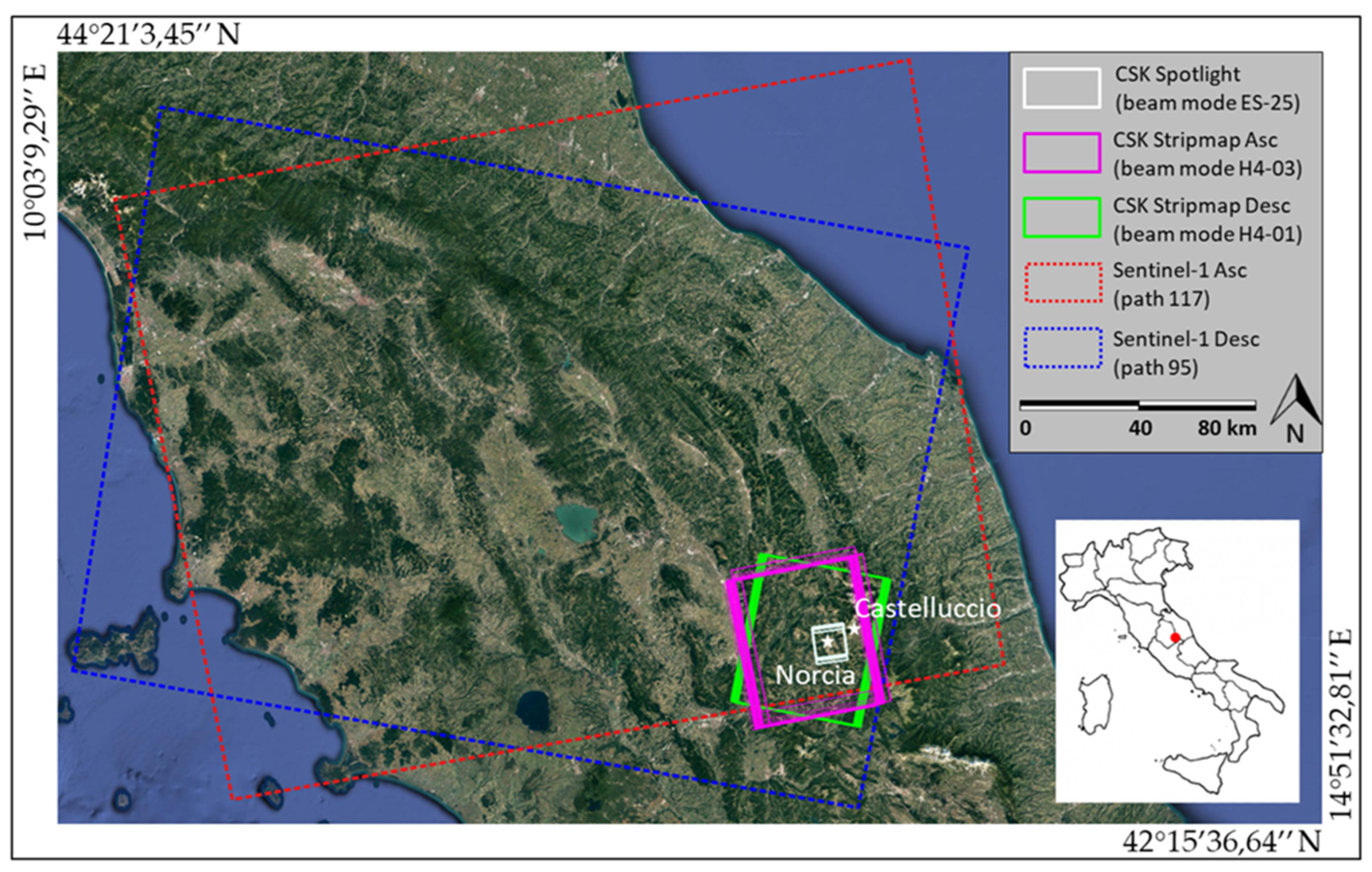




| Acquisition Mode | Geom. Resol. | Ground Resol. | Swath Width | Look Angle | Incidence Angle | Polarization | Ascending | Standard Revisit Time |
|---|---|---|---|---|---|---|---|---|
| Spotlight CSK | 1 m × 1 m | 0.5 m × 0.7 m | 10 km × 10 km | Right | 52.39° | VV | 31 August 2016 (04:58 UTC) 30 October 2016 (04:58 UTC) 31 October 2016 (04:58 UTC) | n.a. |
| StripMap HIMAGE CSK | 3 m × 3 m | 2.1 m × 2.3 m | 40 km × 40 km | 29.35° | HH | 5 October 2016 (04:41 UTC) 21 October 2016 (04:41 UTC) 6 November 2016 (04:41 UTC) 22 November 2016 (04:41 UTC) | 16 days | |
| IW Sentinel-1 | 20 m × 5 m | 3.4 m × 14 m | 250 km | 43.81° | VV | 20 October 2016 (17:04 UTC)—S1B | 6 days | |
| 26 October 2016 (17:04 UTC)—S1A | ||||||||
| 1 November 2016 (17:04 UTC)—S1B | ||||||||
| 7 November 2016 (17:04 UTC)—S1A | ||||||||
| Descending | ||||||||
| StripMap HIMAGE CSK | 3 m × 3 m | 2.1 m × 2.2 m | 40 km × 40 km | 26.58° | HH | 11 October 2016 (17:08 UTC) 27 October 2016 (17:08 UTC) 3 November 2016 (17:08 UTC) 19 November 2016 (17:08 UTC) | 16 days | |
| IW Sentinel-1 | 20 m × 5 m | 4.2 m × 14 m | 250 km | 33.82° | VV | 19 October 2016 (05:19 UTC)—S1B | 6 days | |
| 25 October 2016 (05:19 UTC)—S1A | ||||||||
| 31 October 2016 (05:19 UTC)—S1B | ||||||||
| 6 November 2016 (05:19 UTC)—S1A |
| Dataset | Image #1 (dd/mm/yyyy) | Image #2 (dd/mm/yyyy) | Image #3 (dd/mm/yyyy) |
|---|---|---|---|
| Spotlight | 31 August 2016 | 30 October 2016 | 31 October 2016 |
| StripMap HIMAGE Ascending | 5 October 2016 | 21 October 2016 | 22 November 2016 |
| StripMap HIMAGE Descending | 11 October 2016 | 27 October 2016 | 3 November 2016 |
| Sentinel-1 Ascending | 20 October 2016 | 26 October 2016 | 1 November 2016 |
| Sentinel-1 Descending | 19 October 2016 | 25 October 2016 | 31 October 2016 |
| Dataset | Image #1 (dd/mm/yyyy) | Image #2 (dd/mm/yyyy) |
|---|---|---|
| Spotlight | 30 October 2016 | 31 October 2016 |
| StripMap HIMAGE Ascending | 5 October 2016 | 6 November 2016 |
| StripMap HIMAGE Descending | 27 October 2016 | 3 November 2016 |
| Sentinel-1 Ascending | 26 October 2016 | 1 November 2016 |
| Sentinel-1 Descending | 25 October 2016 | 31 October 2016 |
| Extension (m2) | Overall Accuracy (with Respect to “Ground Truth”) | |
|---|---|---|
| Norcia village | 232,000 m2 | / |
| Damaged areas by “ground truth” | 17,600 m2 | Reference (100%) |
| COSMO-SkyMed Spotlight damage map | 15,900 m2 | 90% |
| COSMO-SkyMed Stripmap damage map | 7900 m2 | 45% |
| Sentinel-1 damage map | Not determinable | |
| COSMO-SkyMed Spotlight (1-m × 1-m res.) | COSMO-SkyMed StripMap HIMAGE (3-m × 3-m res.) | Sentinel-1 (20-m × 5-m res.) | |
|---|---|---|---|
| Availability of t0 acquisition (Italian territory) | No | Yes | Yes |
| Standard Revisit time | n.a. | 16 days | 6 days |
| Post-earthquake acquisition (from the occurrence of the event) and delivery to service provider | up to 1 day (for civil protection request) | up to 1 day (for civil protection request) | from 6 to 1 day |
| Pre-processing, processing, interpretation, and validation (hours/10 km2) | 6 h/10 km2 | ||
| Damage map provision from event (days) | up to 1.25 days | up to 1.25 days | from 6.25 to 1.25 days |
Publisher’s Note: MDPI stays neutral with regard to jurisdictional claims in published maps and institutional affiliations. |
© 2022 by the authors. Licensee MDPI, Basel, Switzerland. This article is an open access article distributed under the terms and conditions of the Creative Commons Attribution (CC BY) license (https://creativecommons.org/licenses/by/4.0/).
Share and Cite
Mazzanti, P.; Scancella, S.; Virelli, M.; Frittelli, S.; Nocente, V.; Lombardo, F. Assessing the Performance of Multi-Resolution Satellite SAR Images for Post-Earthquake Damage Detection and Mapping Aimed at Emergency Response Management. Remote Sens. 2022, 14, 2210. https://doi.org/10.3390/rs14092210
Mazzanti P, Scancella S, Virelli M, Frittelli S, Nocente V, Lombardo F. Assessing the Performance of Multi-Resolution Satellite SAR Images for Post-Earthquake Damage Detection and Mapping Aimed at Emergency Response Management. Remote Sensing. 2022; 14(9):2210. https://doi.org/10.3390/rs14092210
Chicago/Turabian StyleMazzanti, Paolo, Stefano Scancella, Maria Virelli, Stefano Frittelli, Valentina Nocente, and Federico Lombardo. 2022. "Assessing the Performance of Multi-Resolution Satellite SAR Images for Post-Earthquake Damage Detection and Mapping Aimed at Emergency Response Management" Remote Sensing 14, no. 9: 2210. https://doi.org/10.3390/rs14092210
APA StyleMazzanti, P., Scancella, S., Virelli, M., Frittelli, S., Nocente, V., & Lombardo, F. (2022). Assessing the Performance of Multi-Resolution Satellite SAR Images for Post-Earthquake Damage Detection and Mapping Aimed at Emergency Response Management. Remote Sensing, 14(9), 2210. https://doi.org/10.3390/rs14092210