Article

Improving Matching Efficiency and Out-of-domain Reliability of Underwater Gravity Matching Navigation Based on a Novel Soft-margin Local Semicircular-domain Re-searching Model

1
School of Geomatics, Liaoning Technical University, Fuxin 123000, China
2
Qian Xuesen Laboratory of Space Technology, China Academy of Space Technology, Beijing 100094, China
3
Institute for Optimization and Decision Analytics, Liaoning Technical University, Fuxin 123000, China
*
Author to whom correspondence should be addressed.
Remote Sens. 2022, 14(9), 2129; https://doi.org/10.3390/rs14092129
Submission received: 23 February 2022 / Revised: 15 April 2022 / Accepted: 26 April 2022 / Published: 28 April 2022
(This article belongs to the Section Environmental Remote Sensing)

Abstract

:
This paper mainly studies the improvement of the efficiency and out-of-domain reliability of gravity matching navigation for underwater vehicles. To overcome the traversal low-efficiency problem of the traditional terrain contour matching (TERCOM) algorithm and improve the positioning reliability of its out-of-domain mismatches, a novel soft-margin local semicircular-domain re-searching model (SLSR) is proposed by integrating the soft-margin circular grid matching (SCGM) mechanism and the local semicircular grid re-matching (LSGR) mechanism. SCGM uses three times the inertial navigation cumulative error and adds the unit grid resolution as the soft margin boundary to generate the soft-margin circular domain, which contributes to reducing in-domain matching grid points and enhancing the matching efficiency of algorithms. Then the optimal matching position in this soft-margin circular domain is obtained by using the optimization principle of matching indices. LSGR is triggered when the optimal matching position of SCGM is located near the soft-margin circular-domain boundary. It employs this optimal matching point as the center and the unit inertial navigation error as the radius to recreate the semicircular local re-searching matched grid domain (termed as semicircular domain). Moreover, the optimal matching point in this semicircular domain is obtained by the matching index optimization principle, and then it is compared and updated to obtain the final best matching position of SLSR. The simulation results show that SCGM and LSGR of the proposed SLSR method can effectively improve the matching efficiency and out-of-domain matching reliability of underwater navigation, respectively. Under the same testing conditions for the tracking starting points from three gravity regions, the number of out-of-domain mismatches of SLSR, compared with TERCOM, are lower up to 92.68%, 90.24% and 98.62%, while the average matching accuracies are relatively improved by 88.37%, 85.48% and 83.66%, which verifies the validity and feasibility of the proposed SLSR model on improving the efficiency and out-of-domain reliability of underwater gravity matching navigation.

1. Introduction

The INS (Inertial Navigation System) is the most common real-time, autonomous, all-weather navigation technology for underwater vehicles, and it has better high-accuracy positioning characteristics that operate within a very short time [1,2]. However, the intrinsic errors of inertial navigation components (i.e., gyroscopes and accelerometers) and multiple integrals of positioning solutions lead to the accumulation and divergence of INS errors over time [3], making it difficult to achieve the high-accuracy positioning objective of underwater vehicles for a long time. As a result, the aided INS navigation techniques are rising, meaning that INS uses certain aided navigation methods to periodically correct its system parameters to ensure high navigation accuracy [4,5]. Meanwhile, as one of the inherent geographical attributes of the earth, the earth’s gravity field is generally not susceptible to the influence of climate, waves and other environmental factors [6], and it has the advantage of long-term relative stability, so it is more suitable for the application of the aided INS navigation. Currently, the gravity-based aided navigation has become an important hot issue of researches on the underwater aided INS navigation [7,8].
Gravity matching algorithms [9,10] are the critical part of gravity aided INS navigation, and mainly consist of TERCOM [11], ICCP (iterative closest contour point), SITAN (sandia inertial terrain aided navigation) and their variants. In comparison, TERCOM has been extensively studied by scholars, resulting from its insensitivity to initial error, simple calculation mechanism, high positioning accuracy and strong robustness [12,13]. However, its mismatching occurrence in the matching processing will seriously affect the calibration effect of INS system parameters [14,15], and even lead to the failure of underwater sailing mission. Therefore, how to effectively reduce the probability of mismatches without significantly affecting the gravity matching efficiency is an important studied topic about TERCOM.
In terms of the causes and diagnosis of TERCOM mismatches, Wang et al. [14] believed that large initial INS cumulative error and few background features were the reasons for TERCOM mismatching and constructed a TERCOM mismatching diagnosis algorithm based on the similarity extremum detection. Han et al. [14] pointed out that TERCOM mismatching may be caused by large resolution from the reference map and the gravity anomaly distribution uncertainty and proposed a TERCOM mismatching diagnosis model with Restricted Spatial Order Constraints (RSOCs) algorithm. Dai et al. [16] believed that TERCOM and other matching algorithms will have a high probability of mismatches when features are smooth. Wang et al. [17] pointed out that the cross-correlation (COR) may lead to mismatching to a certain extent, while the mean square difference (MSD) is an effective correlation evaluation index. Moreover, they suggested that MSD is selected as the matching indicator, because MSD has slightly higher accuracy than the mean absolution difference (MAD) and COR. Wang et al. [18] indicated that mismatch easily occurs in the region where its gravity-field feature has no significant change. Wang et al. [19] showed that TERCOM in the terrain unmatched region is prone to false peaks and mismatch, due to the influence of measurement errors.
On the other hand, for enhancing the matching efficiency of TERCOM, Yuan et al. [20] constructed a combined underwater aided navigation method by coupling TERCOM/ICCP with the Kalman filter, and they adopted the sliding window to improve its matching efficiency. Li et al. [21] raised the searching model with a hierarchical neighborhood threshold by using the initial searching of four-grid intervals and the re-matching strategy of the neighborhood 24-grid points around its rough-optimal matching point; as a result, they were able to improve the efficiency of the point-by-point traversal search of TERCOM. They [22] also proposed a geodesic-based model by employing the spherical geometry rule and the space-maritime attitude control technology in order to realize the reduction of the searching matching domain and the improvement of the matching efficiency. In summary, most scholars mainly focus on the mismatching causes and diagnosis or the matching accuracy improvement of underwater navigation. However, the researching works are relatively few on simultaneously enhancing matching accuracy and reliability of underwater navigation. As a result, it is necessary to reinforce and perform the corresponding studied works to synchronously realize the performance bi-improvement of the matching efficiency and reliability of underwater gravity matching navigation.
In contrast to previous studies, TERCOM’s mismatches studied in this paper mainly refer to the mismatch occurring outside the square domain of TERCOM; that is, the real position of the underwater vehicle is beyond the range of the matching grids effectively covered by the square domain of TERCOM, termed as the out-of-domain mismatch. No matter how well-matched the matching region is, or if the matching index is completely non-multimodal, it cannot change the inevitable out-of-domain mismatch of TERCOM. Therefore, in this paper, the improvement of the matching efficiency and the avoidance of out-of-domain mismatch are regarded as the researching bi-objectives of the underwater navigation, and we put forward the soft-margin circular grid matching mechanism and the local semicircular grid re-matching mechanism. Furthermore, the novel soft-margin local semicircular-domain re-searching model (SLSR) is proposed by coupling these two mechanisms in order to achieve high matching performance of underwater gravity matching navigation. Furthermore, the numerical experiments verify that two kinds of matching mechanisms can effectively improve the matching efficiency and the out-of-domain matching reliability for the underwater gravity matching navigation, and the proposed SLSR model has the advantages to synchronously enhance both the matching efficiency and out-of-domain reliability, thus demonstrating its outstanding comprehensive matching performance of underwater gravity matching navigation.

2. Model Description

2.1. Matching Characteristic Analysis of the Canonical TERCOM Model

TERCOM, as a canonical gravity aided navigation technique, is a sequence matching algorithm that stemmed from the terrain matching navigation. Its advantages include its simple calculation mechanism, strong robustness and high positioning accuracy [23,24,25]; it has, therefore, become an important and common underwater gravity matching algorithm. In particular, when its matching region is large enough, TERCOM also has the advantage of being insensitive to the initial error; that is, the positioning accuracy is generally not affected by the initial positioning error. However, a too-large matching grid region will inevitably result in a significant reduction on matching efficiency of TERCOM. To adjust and control matching efficiency, TERCOM usually takes the INS tracking ending point as the center and adopts 3 times of INS cumulative drift error ( 3 σ ) as the half-side length to create its square-type grid domain (i.e., square domain), which is used the grid resolution of the gravity reference map as the grid-point interval. Then these square-domain matched points are compared and follow the optimal principle of the matching index to obtain the optimal matched position, which is taken as the real position of the underwater vehicle to adjust and calibrate INS system navigation parameters.
Based on the previous research [1] on positioning statistical results of TERCOM, we find that, according to the matched success rate difference between the tracking real position and these pre-matched points, the surrounding area of TERCOM’s square domain can be divided into 3 types: as the in-domain high-probability matched Region F, the in-domain small-probability matched Region G and the out-of-domain small-probability matched Region H, as shown in Figure 1.
In detail, the Region F in Figure 1 is a circular grid matching domain centered on the nearest neighbor grid position of the INS position and with a half-length 3 σ radius, which is located inside the TERCOM’s square domain and covers most of the matching points of TERCOM. In addition, according to statistical knowledge, the vast majority of tracking real ending positions are also scattered in this region with a probability. Thus, Region F is referred to as the in-domain high-probability matched region, and also known as the circular matching region (termed as circular domain) because of its geometric shape. Region G is the grid matching region of the difference set between TERCOM square domain and the circular domain Region F, that is, the remainder of TERCOM’s square domain beyond the 3 σ circular domain. It scatters a small number of matching points in the TERCOM square domain with a small matching probability, so it is called the in-domain small-probability matched region. Different from Regions F and G, Region H is located outside the TERCOM square domain, but it still scattered a certain amount of the tracking real positions with small probability to be matched, so is it called the out-of-domain small-probability matched region.
Region H is located outside the TERCOM region and is not effectively covered by the effective grid points of TERCOM. If a real position of underwater vehicles falls into this region, it will inevitably lead to the mismatch of TERCOM, so this kind of mismatch is called out-of-domain mismatch, which is the focus of this paper. Although the tracking real positions scattered in this area is of low probability, from the statistical analysis of the pre-tests, it is found that the error of the in-domain mismatch is generally no more than 3 grid resolutions, and the optimal matching position is also located near the real location of underwater vehicles. In contrast, the error of the out-of-domain mismatch is up to several or even dozens of grid resolution, and the optimal matching position is even far away from the real position of vehicles. Therefore, it is necessary to re-study certain matching algorithms for the out-of-domain mismatch to improve their out-of-domain matching reliability, which further improves the calibration effect of INS system parameters to better assist the long-distance high-precision sailing mission of underwater vehicles.
To further improve the matching positioning efficiency of TERCOM and efficiently strengthen its matching reliability on the out-of-domain real position of the underwater vehicle, the SLSR model is proposed in this paper. Thereinto, the soft-margin circular grid matching mechanism is constructed by using the statistical analysis of TERCOM positioning results and the INS error distribution characteristic in order to enhance matching efficiency of gravity navigation algorithms. On the other hand, the local semicircular neighborhood re-matching mechanism for the soft circular domain boundary–matched point is introduced by integrating the soft boundary judgment of the soft circular domain’s optimal matched position and the semicircular-domain local generation mechanism in order to reduce the matching error of matched positions outside the soft circular domain and improve the matching reliability of the out-of-domain mismatched point. As a result, these two core localization mechanisms of the proposed SLSR model are described as follows.

2.2. Soft-Margin Circular Grid Matching Mechanism (SCGM)

In view of the relative position relationships and their difference on the matching success rate between the matching points in different TERCOM regions and the INS 3 σ error area, SCGM is constructed based on the analysis in Figure 1, which can keep the matching success rate with high probability and improve the matching efficiency. Firstly, SCGM uses 3 σ as the boundary of the effective matching points to determine the matching circular domain, as seen in Region F in Figure 1. Secondly, considering the contradiction between the discreteness of the matching grid points in the TERCOM square domain and the continuity of the boundary curve in circular domain, in order to ensure the SCGM mechanism can cover more TERCOM matching points at the circular-domain boundary, a new circular domain with 3 σ + C as the soft boundary (termed as the soft circular domain) is constructed, where C denotes a unit grid resolution of gravity reference map. Moreover, 3 σ + C is also regarded as an upper-bound judging criterion that judges whether some matching point falls into the soft circular domain. Therefore, the calculation expression of coordinates x i 1 , y j 1 for effective matching grid point falling into the soft circular domain of SCGM is shown as follows.
x i 1 = x Z + i   C   y j 1 = y Z + j C   ,               i f         C   i 2 + j 2 3 σ + C
where σ = δ N s a m p l e t 3600 indicates the INS cumulative drift error for N s a m p l e samples with the unit time interval, t, x Z , y Z is the integer coordinate of the nearest neighbor grid position around the INS ending point x I N S , y I N S on the gravity reference map, where x Z = x I N S C and y Z = y I N S C ; denotes the rounding; i r o w , r o w + 1 , , 0 ,   1 , , r o w shows the row grid sequence of the grid points x i 1 , y j 1 deviating from the center position x Z , y Z in the soft circular domain, and r o w = 3 σ C , where represents the ceiling; and j c o l , c o l + 1 , , 0 , 1 , , c o l is the column grid sequence of x i 1 , y j 1 deviating from x Z , y Z and c o l = 3 σ C .
According to the analysis from Equation (1), the number, N , of matching grid points in the soft circular domain of SCGM is jointly determined by the INS error, σ , and grid resolution, C . Under the condition of a fixed C , the number, N , of grid points tends to increase with the increase of INS error, σ , where the total number of grid points in square domain of TERCOM can be written as 6 σ C + 1 2 . Intuitively, we can find from Figure 1 that, with the increase of half-side length of square domain for TERCOM, the more matched points there are in Region G, the more reduced the number of matched grid points of SCGM compared with TERCOM is. As a result, this effectively ensures the relatively higher matching efficiency of SCGM; that is, under the condition of the fixed δ and t (the sampling time interval), the greater the number of tracking samples is, the more significant the matching efficiency of SCGM will be improved theoretically. For example, when δ = 1.8       km / h , N s a m p l e = 50 and t = 20     s (and the grid resolution C = 100     m ), the total number of square-domain matching grid points of TERCOM is 961, and the number, N , of matching grid points of SCGM is 793. Thus, there are 168 fewer matching times, so the executing efficiency of SCGM in matching process is improved by 17.5%. When only the number of samples, N s a m p l e , is changed to 200, the sum number, N , of matching grid points in square domain of TERCOM is 14,641, while the total number, N , of matching points in soft circular domain of SCGM is 11,677. Thus, 2964 times of matching and comparing calculations are performed less, so the execution efficiency based on SCGM in the matching process is improved by 20.2%.
Considering the gravity high precision at the grid resolution position from the gravity reference map, the interpolated gravity based on the interpolation method may not really represent the real gravity value on the matching points. Therefore, for determining the optimal matching position of the underwater vehicle by using SCGM, the re-matching process is equivalent to the canonical TERCOM [11]. Specifically, the matching points x i 1 , y j 1 in the soft circular domain of SCGM are divided by the grid resolution, C , and then mapped to the nearest neighbor grid position, b a s e N s a m p l e , on the gravity reference map by adopting the principle of the rounding, and its gravity value, g N s a m p l e b a s e , on this grid position, b a s e N s a m p l e , is extracted to replace the gravity value of the matching position. Then, based on the matched positions x i 1 , y j 1 in the soft circular domain and the underwater vehicle’s speed, heading, INS error and other information, the gravity values of nearest neighbor grids for the vehicle’s track of this matching point are extracted from the gravity database to obtain the gravity sequence g 1 b a s e g 2 b a s e g N s a m p l e b a s e . Finally, this gravity sequence, g 1 b a s e g 2 b a s e g N s a m p l e b a s e , is compared with the gravity sequence g 1 g 2 g N s a m p l e , measured by the gravimeter, to calculate their mean square error (MSD). Then, following the minimization principle of MSDs for all in-domain matching points of SCGM, the optimal matching position x b e s t 1 , y b e s t 1 for the tracking ending point can be obtained by using Equation (2).
x b e s t 1 = arg min x i 1 1 N s a m p l e i = 1 N s a m p l e g i b a s e g i 2 y b e s t 1 = arg min y j 1 1 N s a m p l e i = 1 N s a m p l e g i b a s e g i 2

2.3. Local Semicircular Grid Re-Matching Mechanism (LSGR)

The SCGM proposed in Section 2.2 can improve the matching efficiency of underwater navigation by reducing the number of matching points in square domain of TERCOM, but it sacrifices the matching performance of TERCOM to region G to some extent; that is, when the real position of underwater vehicles falls into region G, SCGM is difficult to match effectively and further leads to the calibration failure of navigation parameters for INS system. In order to realize the effective matching of SLSR to the vehicle’s real position in Region G and improve its matching reliability to the out-of-domain mismatch points in Region H, the statistical analysis of the matching results between TERCOM and SCGM shows the following: When the real position of the underwater vehicle is located outside the effective matching domain, the optimal matching position based on SCGM is usually located on the boundary grid point of the effective matching region and in the extended region between real position and INS position of underwater vehicles. Therefore, in order to not significantly reduce the matching efficiency of SCGM, LSGR is constructed for the boundary matching points in soft circular domain, which is beneficial to improve the matching reliability of SLSR for out-of-domain mismatches.
The LSGR mechanism is based on SCGM. If the optimal matching position of SCGM is situated on the boundary of the soft circular domain, it, to a certain extent, means that the matching position may not be the real position of underwater vehicles, or even far away from the real position of vehicles, and this may lead to the occurrence of out-of-domain mismatch, which can seriously affect the matching accuracy of underwater gravity navigation. Therefore, to further enhance the re-matching searching performance of LSGR for the boundary optimal matching points of SCGM, it is necessary to relax the lower-bound judgment criterion of whether this optimal matching position is located at the boundary of the soft circular domain of SCGM. Moreover, the judgment expression of the boundary matching point by using SLSR can be expressed as Equation (3).
    P M a t P I N S 3 σ C
where P M a t is the optimal matching position x M a t , y M a t of SCGM; P I N S indicates the tracking ending position x I N S , y I N S derived from INS system; and 3 σ C shows the judgment criterion for the boundary matching points in semicircular domain, where the minus C is to ensure the strong robustness of boundary point discrimination. In addition, to seek higher matching efficiency for LSGR, the right side of Equation (3) can also be adjusted to 3 σ .
According to Equations (1) and (3), LSGR discriminates the matching points falling near the boundary of the soft circular domain and performs the local semicircular grid points re-match. If the optimal matching position x M a t , y M a t of SCGM is judged to be located at the boundary of the soft circular domain, LSGR is activated, and the semicircular local re-matching grid domain (termed as semicircular domain) is generated by using x M a t , y M a t as the center and σ as the radius. The calculation formula of coordinates x m 2 , y n 2 of the matching grid, M m , n 2 , in the semicircular domain can be expressed as follows:
    x m 2 = x M a t + m   C   y n 2 = y M a t + n C   ,               i f         C   m 2 + n 2 σ + C     a n d           P M a t M m , n 2 > 3 σ
where m r , r + 1 , , 0 , 1 , , r represents the row grid sequence of the re-matched grid point x m 2 , y n 2 deviating from the center position x M a t , y M a t in the semicircular domain, and r = r o w 3 . n c , c + 1 , , 0 , 1 , , c is the column grid sequence of x m 2 , y n 2 deviating from the center position x M a t , y M a t and c = c o l 3 . Moreover, the generation process of local semicircular re-matching grid points based on LSGR is shown in Figure 2.
The re-matching searching process of LSGR is similar to that of SCGM. The re-matching points x m 2 , y n 2 in the semicircular domain are divided with the grid resolution, C , and then mapped to the nearest neighbor grid position, b a s e N s a m p l e , on the gravity map by the principle of the rounding, whose extracted gravity, g N s a m p l e b a s e , can be the gravity value of x m 2 , y n 2 . Repeatedly, gravity values of other positions on the track are extracted one by one to obtain the nearest-neighbor gravity sequence, g 1 b a s e g 2 b a s e g N s a m p l e b a s e , which is compared with the observed gravity value sequence, g 1 g 2 g N s a m p l e , and gets its corresponding MSDs. Thus, following the MSD minimization principle, the new optimal matching point x b e s t 2 , y b e s t 2 for the tracking ending position can be obtained in semicircular domain of LSGR, and its formula [11] is as follows:
  x b e s t 2 = arg min x m 2 1 N s a m p l e i = 1 N s a m p l e g i b a s e g i 2 y b e s t 2 = arg min y n 2 1 N s a m p l e i = 1 N s a m p l e g i b a s e g i 2
If the optimal matching positions x b e s t 2 , y b e s t 2 and x b e s t 1 , y b e s t 1 of LSGR and SCGM are denoted as coordinate points E 2 and E 1 , respectively, the optimal matching position x b e s t , y b e s t for the tracking ending point of the proposed SLSR model can be gained by applying the minimization principle of the MSD index, and its calculation formula is as follows:
  x b e s t = arg min         x b e s t i MSD E i y b e s t = arg min y b e s t i               MSD E i , i = 1 , 2

2.4. Implementation of the Proposed SLSR Model

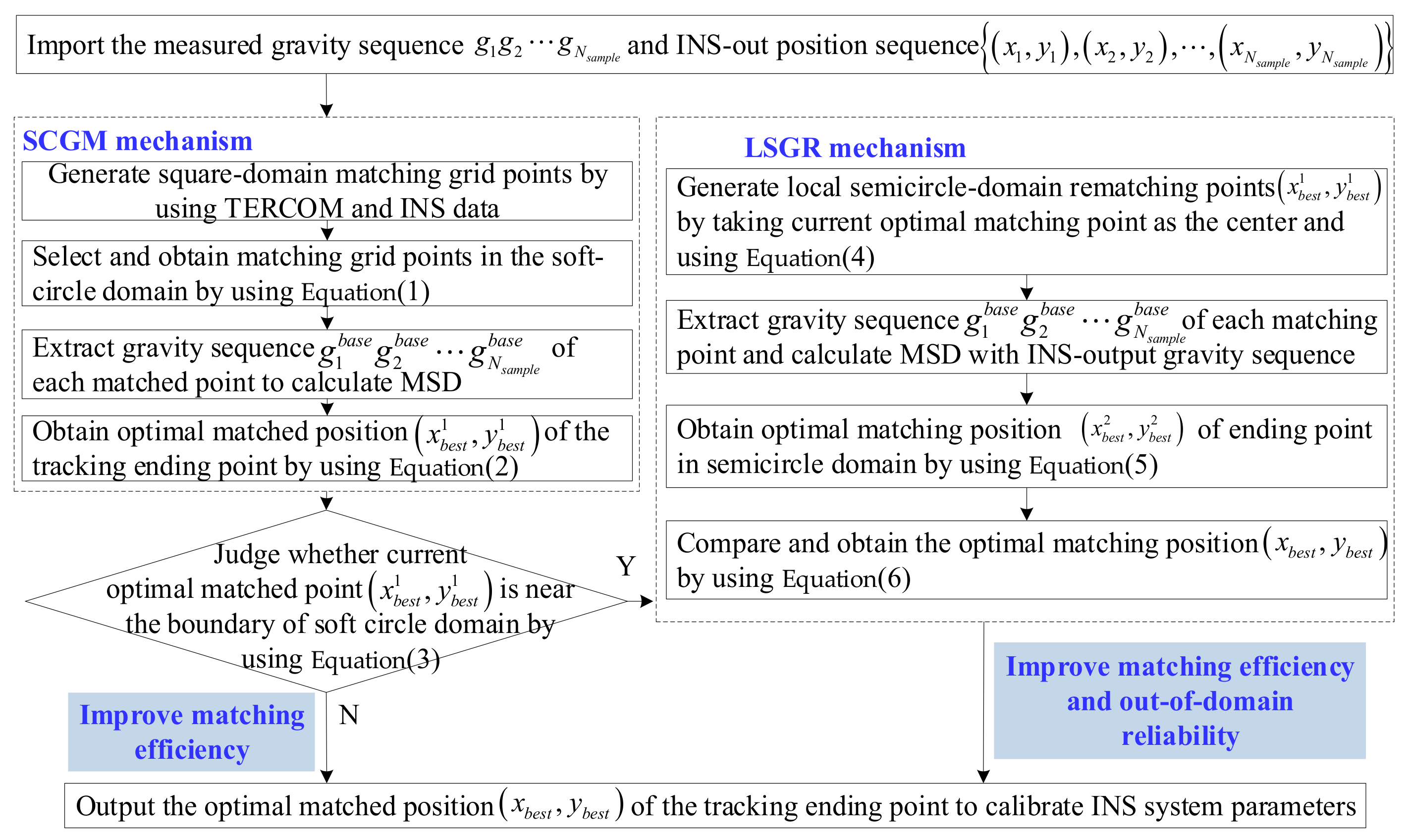
The proposed SLSR model is constructed by integrating SCGM in Section 2.2 and LSGR in Section 2.3 in order to realize bi-objectives on improvement for the matching efficiency and out-of-domain reliability of the underwater gravity matching navigation, and then the optimal matching position obtained by SLSR for the tracking ending point of the underwater vehicle is employed to adjust and calibrate the control parameters of INS. The specific implementation process of SLSR is shown in Figure 3.

3. Experimental Results and Discussions

To validate the superiority and effectiveness of SLSR for improving matching efficiency and reliability on underwater gravity matching navigation, three experiments were executed. Experiment 1 tested the matching efficiency of SLSR in the soft circular domain under different sampling scales. Experiment 2 verified the re-matching reliability of SLSR for the out-of-domain matching points of TERCOM. In Experiment 3, the proposed SLSR model was used to verify its high matching efficiency and better out-of-domain matching reliability on different tracking starting points. All experiments were implemented by Matlab2018a, and the operating platform was a personal computer with Windows 10 and Intel (R) Core (TM) i7-8565U CPU.

3.1. Data

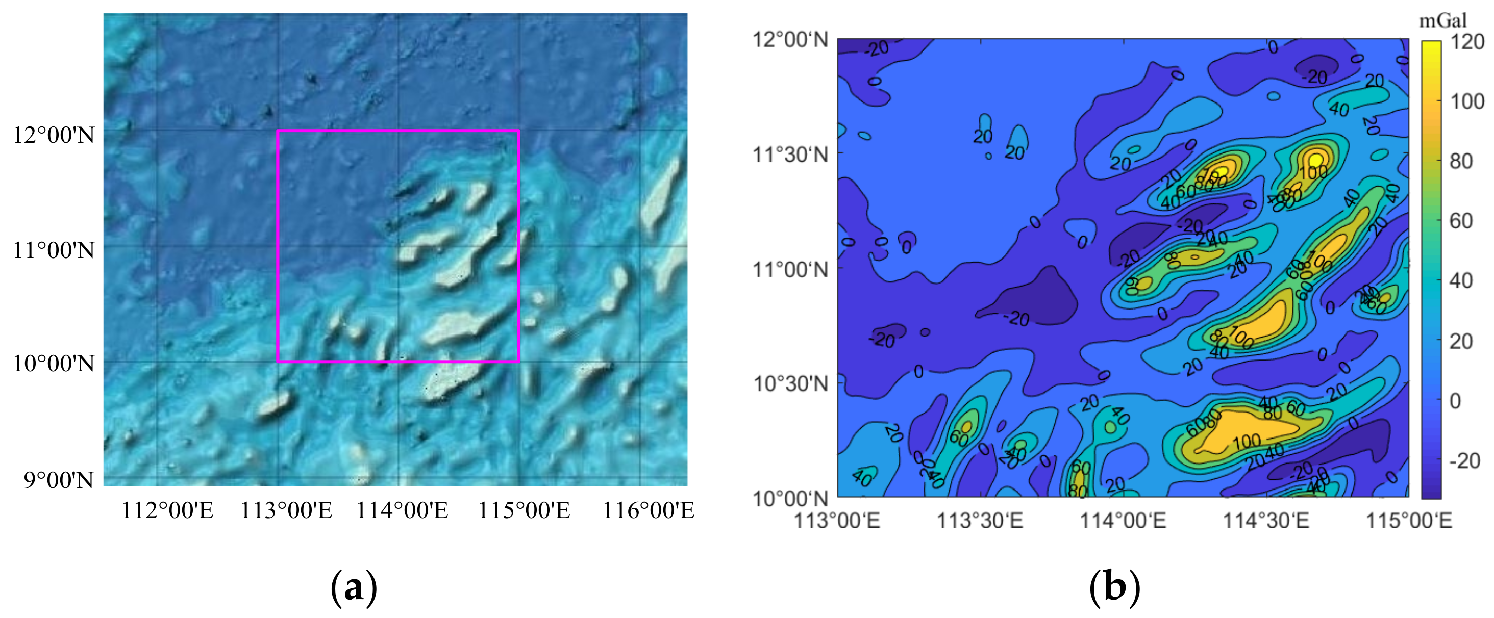
Example data were downloaded from the San Diego website (http://topex.ucsd.edu/, 10 June 2020) from the university of California, where the resolution of gravity data is 1 × 1 . Moreover, the satellite remote sensing graph from the South China Sea for study is plotted in Figure 4a, which is directly taken from the GEBCO website (https://download.gebco.net/, 21 January 2020), and the longitude–latitude scope of the selected studied region is (113°E–115°E, 10°N–12°N) [1]. Meanwhile, we employed a bilinear interpolation method [26] to convert the gravity benchmark data into the gravity data with the 100 m × 100 m grid resolution, as shown in Figure 4b. In detail, in this studied region, the total number of grid points is 2221 × 2221. Moreover, its maximum, minimum and average value of gravity are 130.57 mGal, −33.53 mGal and 15.43 mGal, respectively.
In the simulation sample block, the resolution of the gravity grid after interpolation is 100 m × 100 m, and other simulated parameters [1] are set as listed in Table 1. Moreover, the positioning accuracy in this paper refers to the Euclidean distance from the matching position to the actual position of underwater vehicles. Moreover, the effective matching implies that the positioning accuracy of tests is no more than the diagonal length of the unit grid resolution (i.e., 100 2         m ). As a result, the matching success rate, ξ , can be expressed as (the number of effective matches divided by the total number of tests) ×100%. Furthermore, the mean, SD (standard deviation), and best and worst values on positioning accuracy of N-time tests are recorded, as well as the average matching time T as the performance indices for evaluating underwater gravity matching effects.

3.2. Analysis on Matching Efficiency of SLSR in Soft Circular Domain under Different Sampling Scales

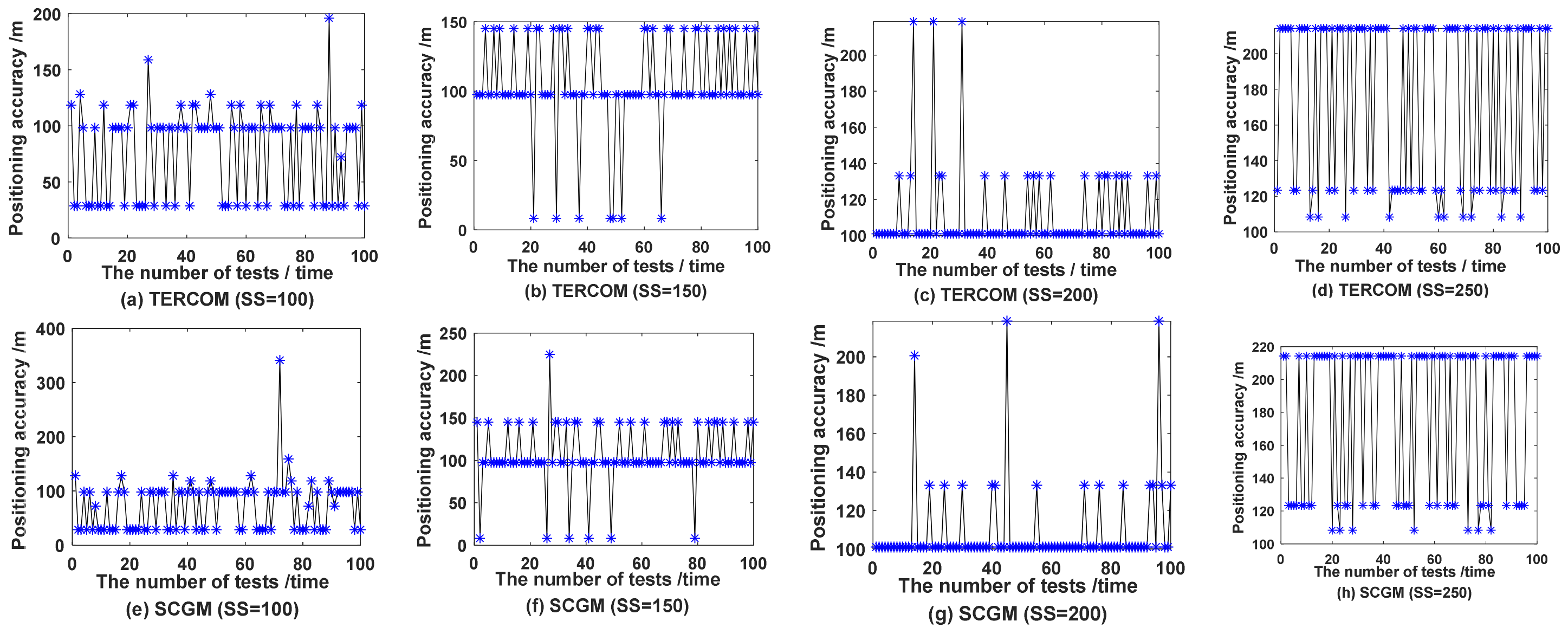
To prove the effectiveness of SLSR’s soft-margin circular grid matching mechanism (i.e., SCGM) for enhancing matching efficiency of underwater gravity matching navigation, the grid coordinate (1050, 960) from the selected region of gravity reference map is set as the sailing starting point for testing. Moreover, the sampling scale (denoted by SS) is set to 100, 150, 200 and 250, respectively, to conduct numerical simulation experiments. Meanwhile, to ensure the fairness and validity of test results, the canonical TERCOM is employed as the compared matching method of SCGM. The comparison results of 100-time independent experiments are listed in Table 2. Simultaneously, their comparative effects on positioning accuracy are intuitively displayed in Figure 5.
According to statistical results of Table 2, the average matching time of SCGM is significantly smaller than that of TERCOM. For four different sampling scales, the T index values of SCGM, compared with TERCOM, are reduced by 23.8%, 16.4%, 17.1% and 27.8% respectively, and the average matching time was saved by about 20%. These analysis results are mutually confirmed by the theoretical inference in Section 2.2, which indicates that SCGM can effectively enhance matching efficiency of underwater gravity matching navigation. Re-combined with the intuitive comparison diagram of positioning accuracy in Figure 5, in terms of matching accuracy, a majority of the index values of SCGM are almost the same as those of TERCOM, and there is no significant difference in matching success rate between them, indicating that SCGM does not significantly reduce the matching accuracy of TERCOM. In summary, these above conclusions certify the feasibility and effectiveness of the proposed soft-margin circular grid matching mechanism, compared with TERCOM, to improve the matching efficiency.
To further analyze the effectiveness of the soft-margin circular grid matching mechanism of SLSR in improving the efficiency of underwater gravity matching navigation, that is, to explore the reason why the matching efficiency of SCGM is superior to TERCOM, the scatter distribution comparison diagram on matching positions of TERCOM and real positions of the underwater vehicle are drawn under different sampling scales, as shown in Figure 6. (Note that the INS nearest neighbor grid points are taken as the origin of coordinates to guarantee that 100-time testing positions can be drawn in the same figure, and the basic unit of coordinates is set to grid resolution, i.e., 100 m).
As shown Figure 6, the matching positions of TERCOM under different sampling scales are almost all located in the 3 σ square grid region, and most of them are scattered in the 3 σ circular domain, while only a small number are located outside. This characteristic of the matching points’ distribution conforms to the 3 σ principle of error normal distribution and covers the real position of vehicles with a large probability, which is conducive to the matching efficiency of gravity matching navigation. In summary, these results, to some extent, prove the feasibility of the soft-margin circular grid matching mechanism in SLSR to strengthen the matching efficiency of underwater gravity navigation. In order to further analyze the actual matching effect of the proposed SCGM, the scatter distribution diagram on matching positions of SCGM and real positions of vehicles under different sampling scales is displayed, as shown in Figure 7.
As seen from Figure 7, the soft circular domain of SCGM almost covers the real positions of the tracking ending point and achieves better underwater matching performance under four different sampling scales, and this, again, verifies the effectiveness of SLSR based on the soft-margin circular grid matching mechanism in enhancing matching efficiency for underwater gravity matching navigation.
By comprehensively analyzing the relative position difference between matching positions and real positions in Figure 6 and Figure 7, it can be found that one of the reasons for the deviation between both positions is that the actual position of the sailing ending point of vehicles is outside the boundary of the soft-margin matching grid region, leading to the matching failure phenomenon caused by “all matching grid points can never effectively cover the real position of underwater vehicles”, that is, the occurrence of out-of-domain mismatch for TERCOM or SCGM, as shown in the position with the * symbol in Figure 6a and Figure 7a,b, respectively. In the next section, for the case of the out-of-domain mismatch, the performance analysis experiment of improving the out-of-domain mismatch reliability is carried out by using the proposed SLSR model with the local semicircular grid re-matching mechanism.

3.3. Analysis on the Out-of-Domain Matching Reliability of SLSR

To testify the re-matching reliability of SLSR for the out-of-domain matching points of TERCOM, the sampling scale SS = 150 is taken as an example, and TERCOM and SCGM are taken as the comparison algorithm. Meanwhile, to ensure the fairness and validity of test results, the number of tests is set to 10,000, while other parameters are set according to Section 3.1 and Section 3.2. Firstly, TERCOM is used to conduct 10,000 independent tests and save its original data, such as the random gravity sequence, the random position of the INS ending point, etc. Secondly, the data saved by TERCOM are used as the experimental input configuration of SCGM and SLSR to complete their tests and record the results of matching accuracy, running time, etc. Finally, the comparative statistical results in 10,000 times of tests are shown in Table 3.
According to the analysis in Table 3, SLSR is all better than TERCOM and SCGM on the statistical results of matching accuracy and success rate. In terms of average running time (i.e., the T index), the matching time of SLSR is not significantly different from SCGM, about 16.4% higher than TERCOM, which indicates that SLSR can maintain high matching efficiency for the real ending position of underwater vehicles. Moreover, it is verified that the proposed SLSR can enhance the positioning accuracy of out-of-domain matching positions of TERCOM while maintaining the good matching efficiency of SCGM. In particular, the worst index of SLSR is significantly better than TERCOM in 10,000 tests, indicating that the proposed SLSR has a stronger TERCOM’s out-of-domain mismatching avoidance performance, but the better matching effect of SLSR on the out-of-domain mismatches is not highlighted, due to the relatively small number of mismatches. Thus, in order to further testify performance differences of different matching algorithms on TERCOM’s out-of-domain mismatches, it is necessary to carry out the separate statistics on matching results for out-of-domain mismatches of TERCOM in 10,000 tests. Firstly, the S e q m i s o u t of the out-of-domain mismatches in the TERCOM test is determined and recorded by the following out-of-domain mismatches criterion formula:
      x       coordinate :             x r e a l < C x Z r o w         |             x r e a l > C x Z + r o w                 or       y       coordinate :             y r e a l < C y Z c o l             |             y r e a l > C y Z + c o l
where x r e a l and y r e a l represent the x-coordinate and y-coordinate of the real position for the underwater vehicle, respectively. Note that the number of out-of-domain mismatches is denoted as NOM in this paper. Secondly, following this out-of-domain mismatching sequence, S e q m i s o u t , the corresponding matching results of SCGM and SLSR are extracted and recorded. Finally, the comparative statistical results of different matching algorithms for the out-of-domain mismatches are calculated and listed in Table 4.
As analyzed in Table 4, SLSR can effectively reduce the occurrence times of TERCOM out-of-domain mismatches by 73.17%. For the matching accuracy statistical results, SLSR is superior to TERCOM and SCGM. In detail, the average matching accuracy of SLSR is less than the diagonal length of a grid, which achieves the effective average positioning of SLSR for the out-of-domain mismatching points of TERCOM. The smaller SD index of SLSR indicates that the proposed model has better matching robustness. In particular, the worst matching index of SLSR is better than the mean index value of TERCOM, and this more effectively verifies the good repositioning performance of the proposed SLSR for the out-of-domain mismatching points. Compared with TERCOM, SLSR, on four accuracy indexes, can improve by 80.72%, 81.06%, 73.70% and 94.28%, respectively. Recombined with statistical results of Table 3, we can find that the average matching time of SCGM is about 17.2% lower than TERCOM, but its larger out-of-domain mismatching error is caused by the loss of matching points in region G of TERCOM. Moreover, the T-index value of SLSR is reduced by 16.4%, which further verifies that the proposed SLSR can not only improve the matching efficiency of TERCOM, but also enhance the re-matching reliability of the out-of-domain mismatching points of TERCOM.
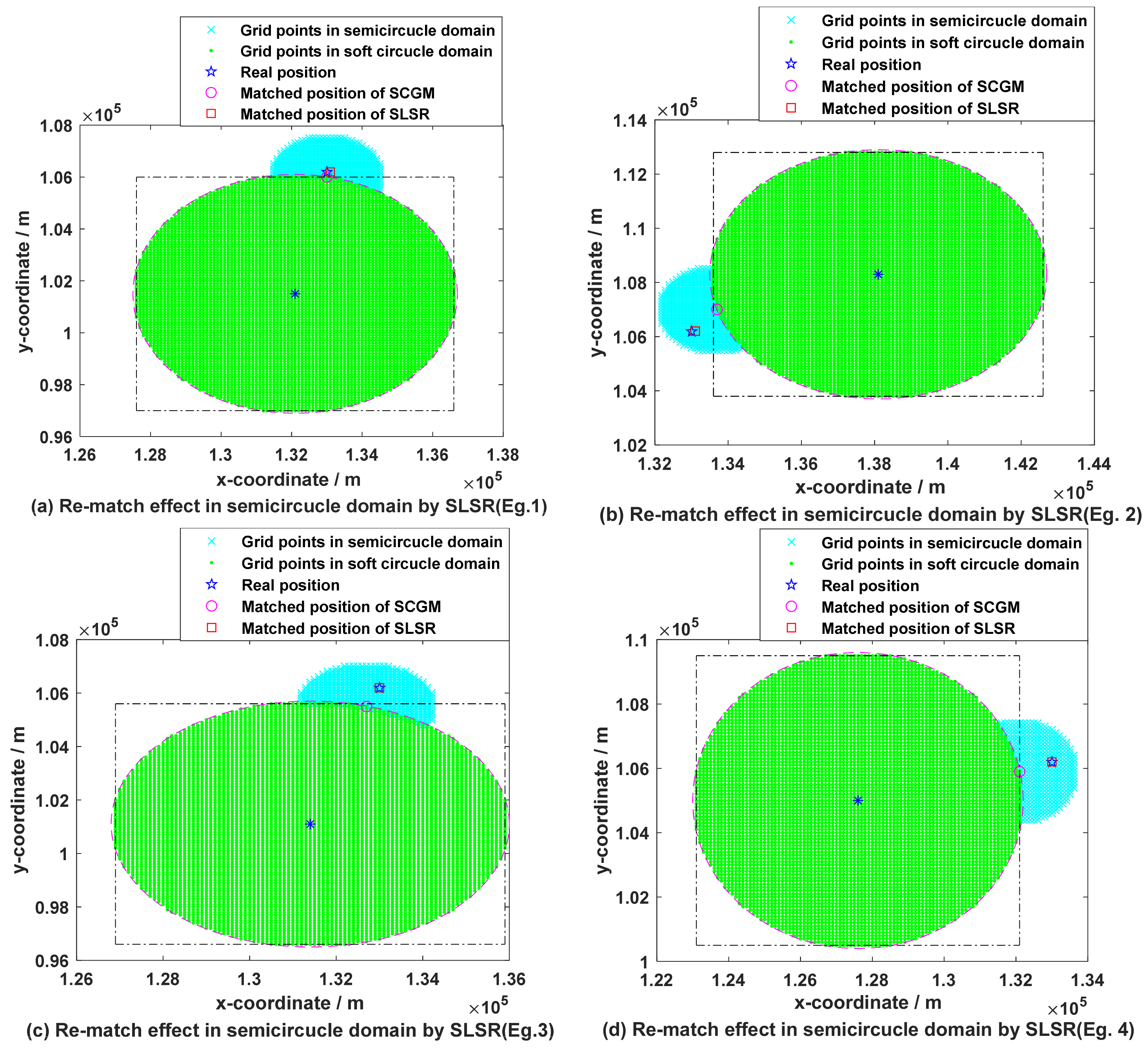
To further illustrate the good re-matching reliability of SLSR for out-of-domain mismatching points of TERCOM, some semicircular re-matching instances are drawn for the out-of-domain mismatching points, as shown in Figure 8.
As shown in Figure 8, SLSR can achieve high-accuracy positioning for the mismatching points of TERCOM by re-matching and searching the local semicircular domain around the boundary matching points in the soft circular domain to obtain the better matching position for the sailing ending point. Meanwhile, SLSR shows the effectiveness of the semicircular domain re-matching for different boundary grid points, indicating that the proposed SLSR model has the advantages of good matching robustness and improving the reliability of the out-of-domain mismatching points. According to the dot-dashed line box positions of TERCOM square-domain boundary in each sub-graph of Figure 8, it can be seen that these real positions of the underwater vehicle are all located outside the square region of TERCOM, thus inevitably leading to the matching failure (i.e., out-of-domain mismatch) of TERCOM. Although TERCOM carries out the matching comparison of more grid points, it still cannot avoid the occurrence of out-of-domain mismatch. SLSR, on the other hand, benefits from the effective coverage of the semicircular domain for the real position of vehicles and achieves better matching of the out-of-domain mismatching points with fewer matching comparisons, thus ensuring that SLSR is superior to TERCOM in both the matching efficiency and out-of-domain matching reliability of underwater gravity navigation. To sum up, these results further verify the high matching efficiency and good positioning reliability of SLSR for the out-of-domain matching points of TERCOM.

3.4. Analysis on Out-of-Domain Matching Efficiency and Reliability of SLSR under Different Tracking Starting Points

To certify the excellent out-of-domain matching performance of SLSR under different tracking starting points, taking sampling scale SS = 150 as an example, the navigation starting point grid coordinates A (1350, 1450), B (1250, 1050) and C (1700, 350) are selected, respectively, and tested according to the parameter settings in Section 3.1 and Section 3.2. At the same time, in order to ensure the fairness of performance comparison between TERCOM and SLSR for underwater gravity matching navigation, TERCOM is firstly used for 10,000 tests, and its out-of-domain mismatching points are recorded, and the corresponding test parameter data, such as INS position deviation and tracking gravity error sequence, are saved. Secondly, the parameter data of the out-of-domain mismatches of TERCOM are employed as the input of SLSR, and the re-matching positioning of these out-of-domain matched points is performed. Finally, the positioning results of the out-of-domain matching points by SLSR are collected and recorded and compared with TERCOM, as shown in Table 5.
From Table 5, under the same test conditions for out-of-domain mismatches of the TECOM, SLSR can effectively reduce the occurrence probability of the out-of-domain mismatch, and the number of its mismatch, compared with TERCOM, decreases by 92.68%, 90.24% and 98.62%, respectively. On the statistical results of positioning accuracy of the out-of-domain mismatch points, SLSR is significantly superior to the traditional TERCOM. The average matching accuracy of SLSR is less than the diagonal length of a grid and is 88.37%, 85.48% and 83.66% higher than TERCOM, respectively, which verifies that the novel soft-margin local semicircular domain researching model has good effectiveness in re-matching positioning for the out-of-domain mismatch points and high matching reliability. For the T index, the positioning efficiency of SLSR decreases, compared with TERCOM, by more than 18%, thus indicating that the proposed SLSR model has faster matching efficiency in an underwater gravity matching navigation. In summary, these results further prove the advantages of the novel soft interval local semicircular domain research method proposed in this paper for effectively enhancing the matching efficiency for underwater gravity matching navigation and the positioning reliability for out-of-domain matching positions.
To intuitively display the high-precision re-matching comparison effect of SLSR on out-of-domain mismatching points of TERCOM, the error statistical histogram comparison for out-of-domain matching points under different tracking starting points and the matching dispersed comparison for out-of-domain matching points within different gravity intervals are drawn in Figure 9 and Figure 10, respectively.
From Figure 9, under different track starting points, we can see that a vast majority of the out-of-domain mismatching errors of TERCOM exceed 5 or even 10 grid resolutions, and this seriously affects its positioning effect of underwater gravity matching navigation. On the other hand, SLSR can effectively realize the re-matching and positioning of these out-of-domain matching points, and its more than 90% positioning accuracy is less than one grid, which effectively verifies that the proposed SLSR model has strong re-positioning performance and better out-of-domain matching reliability for the out-of-domain mismatching points of TERCOM.
As shown in Figure 10, for the matching and positioning of TERCOM out-of-region matching points within different gravity intervals, the optimal re-matching positions of SLSR almost all gather in a small neighborhood with the real position of underwater vehicles as the center, while the optimal matching positions of TERCOM are scattered in a larger space around the real position. Moreover, the results show that SLSR can better and more accurately locate the coordinates of the out-of-region matching points, so as to effectively correct and calibrate the navigation parameters of INS system, thus contributing to the realization of long endurance and long-distance navigation objectives of underwater vehicles. On the other hand, considering that the ending points of three tracks fall in different gravity intervals, it indicates to some extent that SLSR has high matching accuracy and good positioning reliability for the out-of-domain matching points in different gravity intervals. In summary, the abovementioned conclusions effectively prove the effectiveness and feasibility of the novel soft-margin local semicircular domain re-searching method for synchronously improving the efficiency and out-of-domain reliability of underwater gravity matching navigation.

4. Conclusions

In this paper, a novel soft-margin local semicircular-domain re-searching method is proposed for improving the matching efficiency and out-of-domain positioning reliability of underwater gravity matching navigation.
(1)
The establishment of a novel soft-margin local semicircular-domain re-searching method: Since the traditional TERCOM is inefficient in traversal search of fully matched points in the square grid domain, and it is difficult to locate the positions outside its square domain, the novel soft-margin local semicircular-domain re-searching method was proposed. The advantages of the proposed model are as follows: Based on the sum of the three-times INS cumulative error ( 3 σ ) and unit grid resolution as the boundary, the soft circular domain of matching grid points is constructed, and then these matching points in the soft circular domain are compared by following the optimal principle of matching index, so as to realize the high matching efficiency of the soft circular-domain grid matching mechanism for matching the optimal position. If the optimal matching position of the soft circular domain is located near its boundary, the semicircular domain of the local semicircular grid re-matching mechanism is generated around this optimal matching position and the re-matching comparison of these new matching points is performed, so as to improve the reliability of out-of-domain matching points.
(2)
The feasibility and effectiveness of the novel soft-margin local semicircular-domain re-searching model for improving the matching efficiency and out-of-domain reliability of underwater gravity navigation: The efficiency and out-of-domain reliability of underwater gravity matching navigation are closely related to the number of matched grid points and their coverage capacity for the out-of-domain real position of the underwater vehicle, respectively. To verify the effectiveness of the novel soft-margin local semicircular-domain re-searching model in improving the matching efficiency and out-of-domain matching reliability of underwater gravity navigation, the average matching time, the number of out-of-domain mismatches and the statistical results of matching accuracy were considered as the evaluation criteria for the performance of the matching algorithms. The re-matching experiments of different sampling scales and out-of-domain matching points were carried out to verify the high matching efficiency and good out-of-domain positioning reliability of the novel soft-margin local semicircular-domain re-searching model.
(3)
Verification of the improvement on the efficiency and out-of-domain matching reliability of underwater matching navigation: Under the same experimental conditions, the novel soft-margin local semicircular-domain re-searching model was tested by taking the parameter setting of this paper as an example. The test results show that the matching efficiency of the novel soft-margin local semicircular-domain re-searching model is 18% higher than that of the traditional TERCOM for three different tracking starting points. Compared with TERCOM, its number of out-of-domain mismatch points is decreased by 92.68%, 90.24% and 98.62%, respectively. Moreover, the average out-of-domain matching accuracy is increased to 91.79, 107.86 and 88.98 from 789.54, 742.61 and 544.66 of TERCOM; that is, the matching accuracy is improved by 88.37%, 85.48% and 83.66%, respectively. In summary, the novel soft-margin local semicircular-domain re-searching model can enhance the matching efficiency of underwater gravity matching navigation and effectively improve the positioning reliability of out-of-domain matched positions of underwater vehicles.

Author Contributions

Conceptualization, S.Z., W.Z. and Z.L.; data curation, S.Z.; formal analysis, S.Z. and Z.L.; funding acquisition, S.Z., W.Z. and A.X.; methodology, S.Z.; software, S.Z. and Z.L.; writing—original draft, S.Z.; writing—review and editing, S.Z., W.Z., Z.L., H.Z. and A.X. All authors have read and agreed to the published version of the manuscript.

Funding

This work was supported by the China Postdoctoral Science Foundation, under grant 2021M701537; the National Natural Science Foundation of China, under grants 41774014 and 41574014; the Liaoning Revitalization Talents Program, under grant XLYC2002082; the Frontier Science and Technology Innovation Project and the Innovation Workstation Project of Science and Technology Commission of the Central Military Commission, under grant 085015; and the Outstanding Youth Fund of China Academy of Space Technology.

Acknowledgments

We greatly appreciate the helpful suggestions from editors and anonymous reviewers.

Conflicts of Interest

The authors declare no conflict of interest.

References

  1. Zhao, S.; Zheng, W.; Li, Z.; Xu, A.; Zhu, H. Improving Matching Accuracy of Underwater Gravity Matching Navigation Based on Iterative Optimal Annulus Point Method with a Novel Grid Topology. Remote Sens. 2021, 13, 4616. [Google Scholar] [CrossRef]
  2. Huang, H.; Tang, J.; Liu, C.; Zhang, B.; Wang, B. Variational Bayesian-Based Filter for Inaccurate Input in Underwater Navigation. IEEE Trans. Veh. Technol. 2021, 70, 8441–8452. [Google Scholar] [CrossRef]
  3. Han, Y.; Wang, B.; Deng, Z.; Fu, M. A Matching Algorithm Based on the Nonlinear Filter and Similarity Transformation for Gravity-Aided Underwater Navigation. IEEE/ASME Trans. Mechatron. 2018, 23, 646–654. [Google Scholar] [CrossRef]
  4. Wang, B.; Zhu, J.; Ma, Z.; Deng, Z.; Fu, M. Improved Particle Filter-Based Matching Method with Gravity Sample Vector for Underwater Gravity-Aided Navigation. IEEE Trans. Ind. Electron. 2020, 68, 5206–5216. [Google Scholar] [CrossRef]
  5. Jeon, H.C.; Park, W.J.; Park, C.G. Grid Design for Efficient and Accurate Point Mass Filter-Based Terrain Referenced Navigation. IEEE Sens. J. 2017, 18, 1731–1738. [Google Scholar] [CrossRef]
  6. Lee, C.; Oh, J.; Hong, C.; Youn, J. Automated Generation of a Digital Elevation Model Over Steep Terrain in Antarctica From High-Resolution Satellite Imagery. IEEE Trans. Geosci. Remote Sens. 2015, 53, 1186–1194. [Google Scholar] [CrossRef]
  7. Liu, H.; Wu, L.; Bao, L.; Li, Q.; Zhang, P.; Wang, Y. Gravity matching navigation algorithm based on multiscale search and Hadamard transformed difference. ISA Trans. 2021, in press. [Google Scholar] [CrossRef]
  8. Wang, Z.; Huang, Y.; Wang, M.; Wu, J.; Zhang, Y. A Computationally Efficient Outlier-Robust Cubature Kalman Filter for Underwater Gravity Matching Navigation. IEEE Trans. Instrum. Meas. 2022, 71, 8500418. [Google Scholar] [CrossRef]
  9. Park, J.; Park, Y.-G.; Park, C.G. Parameter Estimation of Radar Noise Model for Terrain Referenced Navigation Using a New EM Initialization Method. IEEE Trans. Aerosp. Electron. Syst. 2019, 56, 107–112. [Google Scholar] [CrossRef]
  10. Wang, B.; Yu, L.; Deng, Z.; Fu, M. A Particle Filter-Based Matching Algorithm with Gravity Sample Vector for Underwater Gravity Aided Navigation. IEEE/ASME Trans. Mechatron. 2016, 21, 1399–1408. [Google Scholar] [CrossRef]
  11. Golden, J.P. Terrain contour matching (TERCOM): A cruise missile guidance aid. In Image Processing for Missile Guidance; International Society for Optics and Photonics: Bellingham, WA, USA, 1980; Volume 238, pp. 10–18. [Google Scholar]
  12. Xiao, J.; Duan, X.; Qi, X.; Liu, Y. An Improved ICCP Matching Algorithm for use in an Interference Environment during Geomagnetic Navigation. J. Navig. 2020, 73, 56–74. [Google Scholar] [CrossRef]
  13. Wu, L.; Wang, H.; Chai, H.; Hsu, H.; Wang, Y. Research on the Relative Positions-Constrained Pattern Matching Method for Underwater Gravity-Aided Inertial Navigation. J. Navig. 2015, 68, 937–950. [Google Scholar] [CrossRef] [Green Version]
  14. Wang, S.; Cheng, G.; Zhao, J. The study on the TERCOM mismatch diagnostic based on detecting the extreme value of similarity. In Proceedings of the 2011 Second International Conference on Mechanic Automation and Control Engineering, Hohhot, China, 15–17 July 2011; IEEE: Piscataway, NJ, USA, 2011; pp. 4623–4626. [Google Scholar]
  15. Han, Y.; Wang, B.; Deng, Z.; Wang, S.; Fu, M. A Mismatch Diagnostic Method for TERCOM-Based Underwater Gravity-Aided Navigation. IEEE Sens. J. 2017, 17, 2880–2888. [Google Scholar] [CrossRef]
  16. Dai, T.; Miao, L.; Guo, Y. A Real-Time Mismatch Detection Method for Underwater Database-Referenced Navigation. Sensors 2019, 19, 307. [Google Scholar] [CrossRef] [Green Version]
  17. Wang, J.; Tang, Y.-G.; Chen, C.-X.; Li, J.-X.; Chen, C.; Zhang, A.-Q.; Li, Y.-P.; Li, S. Terrain matching localization for hybrid underwater vehicle in the Challenger Deep of the Mariana Trench. Front. Inf. Technol. Electron. Eng. 2020, 21, 749–759. [Google Scholar] [CrossRef]
  18. Wang, C.; Wang, B.; Deng, Z.; Fu, M. A Delaunay Triangulation-Based Matching Area Selection Algorithm for Underwater Gravity-Aided Inertial Navigation. IEEE/ASME Trans. Mechatron. 2021, 26, 908–917. [Google Scholar] [CrossRef]
  19. Wang, R.; Chen, Y.; Li, Y.; Xu, P.; Shen, P. High-precision initialization and acceleration of particle filter convergence to improve the accuracy and stability of terrain aided navigation. ISA Trans. 2021, 110, 172–197. [Google Scholar]
  20. Yuan, G.; Zhang, H.; Yuan, K.; Tao, C. A Combinational Underwater Aided Navigation Algorithm Based on TERCOM/ICCP and Kalman Filter. In Proceedings of the 2011 Fourth International Joint Conference on Computational Sciences and Optimization, Kunming and Lijiang City, China, 15–19 April 2011; IEEE: Piscataway, NJ, USA, 2011; pp. 952–955. [Google Scholar]
  21. Li, Z.; Zheng, W.; Wu, F.; Fang, J. Improving the matching efficiency of underwater gravity matching navigation based on a new hierarchical neighborhood threshold method. Chin. J. Geophys. 2019, 62, 2405–2416. (In Chinese) [Google Scholar]
  22. Li, Z.; Zheng, W.; Wu, F. Geodesic-Based Method for Improving Matching Efficiency of Underwater Terrain Matching Navigation. Sensors 2019, 19, 2709. [Google Scholar] [CrossRef] [Green Version]
  23. Zhao, L.; Gao, N.; Huang, B.; Wang, Q.; Zhou, J. A Novel Terrain-Aided Navigation Algorithm Combined with the TERCOM Algorithm and Particle Filter. IEEE Sens. J. 2014, 15, 1124–1131. [Google Scholar] [CrossRef]
  24. Zhang, J.; Zhang, T.; Shin, H.-S.; Wang, J.; Zhang, C. Geomagnetic Gradient-Assisted Evolutionary Algorithm for Long-Range Underwater Navigation. IEEE Trans. Instrum. Meas. 2020, 70, 2503212. [Google Scholar] [CrossRef]
  25. Dai, T.; Miao, L.; Shao, H. A robust underwater navigation method fusing data of gravity anomaly and magnetic anomaly. Int. J. Syst. Sci. 2019, 50, 679–693. [Google Scholar] [CrossRef]
  26. Salavasidis, G.; Munafo, A.; McPhail, S.D.; Harris, C.A.; Fenucci, D.; Pebody, M.; Rogers, E.; Phillips, A.B. Terrain-Aided Navigation with Coarse Maps—Toward an Arctic Crossing with an AUV. IEEE J. Ocean. Eng. 2021, 46, 1192–1212. [Google Scholar] [CrossRef]
Figure 1. Matching-region classification of the surrounding area of TERCOM’s square domain.
Remotesensing 14 02129 g001
Figure 2. Diagram of the generation process of local semicircular re-matching grid points based on LSGR.
Remotesensing 14 02129 g002
Figure 3. Implementation flow diagram of the proposed SLSR model.
Remotesensing 14 02129 g003
Figure 4. Illustration of (a) satellite remote sensing graph and (b) gravity reference map for the selected studied region.
Remotesensing 14 02129 g004
Figure 5. Comparison on positioning accuracy under different sampling scales.
Remotesensing 14 02129 g005
Figure 6. Matching scatter distribution of TERCOM under different sampling scales.
Remotesensing 14 02129 g006
Figure 7. Matching scatter distribution of SCGM under different sampling scales.
Remotesensing 14 02129 g007
Figure 8. Semicircular domain re-matching diagram of SLSR for out-of-domain mismatching points.
Remotesensing 14 02129 g008
Figure 9. Histogram comparison of error statistics of out-of-region matching points at different tracking starting points.
Remotesensing 14 02129 g009
Figure 10. Matching dispersed comparison for out-of-domain matching points in different gravity intervals.
Remotesensing 14 02129 g010
Table 1. The setting of other simulation parameters in experiments.
ParameterValue (Unit)ParameterValue (Unit)
Accelerometer constant zero deviation10−3 m/s2Gyroscope drift0.01°/h
Heading (north by east)70°Heading error0.05°
Speed10 m/s Speed error 0.04 m/s
Initial position error 0 mGravity random noise1 mGal
Tracking sampling period20 sTracking sampling scale-
Table 2. Statistical results of two kinds of gravity matching models under different sampling scales.
SSAlg. ξ /% Mean/mSD/mBest/mWorst/mT/s
100TERCOM9877.2039.7628.62196.102.48 × 10−2
SCGM9872.7346.4628.62341.151.89 × 10−2
150TERCOM70105.5334.428.30145.125.06 × 10−2
SCGM69111.7061.548.30625.984.23 × 10−2
200TERCOM97110.6322.87101.00218.561.23 × 10−1
SCGM97108.5221.39101.00218.561.02 × 10−1
250TERCOM40176.3546.76108.33214.192.63 × 10−1
SCGM39177.7145.99108.33214.191.90 × 10−1
Table 3. Statistical results for TERCOM’s out-of-domain mismatches based on different algorithms.
Alg. ξ /% Mean/mSD/mBest/mWorst/MT/s
TERCOM68.61106.11 49.21 8.30 1170.50 4.95 × 10⁻²
SCGM68.39107.91 61.31 8.30 1843.95 4.10 × 10⁻²
SLSR68.88104.3737.088.30307.814.14 × 10−2
Table 4. Compared matching results of different algorithms for out-of-domain mismatches.
Alg.NOM/TimeMean/mSD/mBest/mWorst/m
TERCOM41536.06270.95145.121170.50
SCGM41667.07334.06145.121843.95
SLSR11103.3551.318.30307.81
Table 5. Statistical results of out-of-domain matching under different tracking starting points.
Starting PointAlg.NOM/TimeMean/mSD/mBest/mWorst/mT/s
ATERCOM41789.54442.66224.712194.024.97 × 10−2
SLSR391.79188.848.301076.814.06 × 10−2
BTERCOM41742.61381.49224.711857.804.86 × 10−2
SLSR4107.86120.358.30632.283.98 × 10−2
CTERCOM45544.66370.07145.121548.125.01 × 10−2
SLSR288.9840.938.30197.314.07 × 10−2
Publisher’s Note: MDPI stays neutral with regard to jurisdictional claims in published maps and institutional affiliations.