InSAR Study of Landslides: Early Detection, Three-Dimensional, and Long-Term Surface Displacement Estimation—A Case of Xiaojiang River Basin, China



Abstract
1. Introduction
2. Study area and Datasets
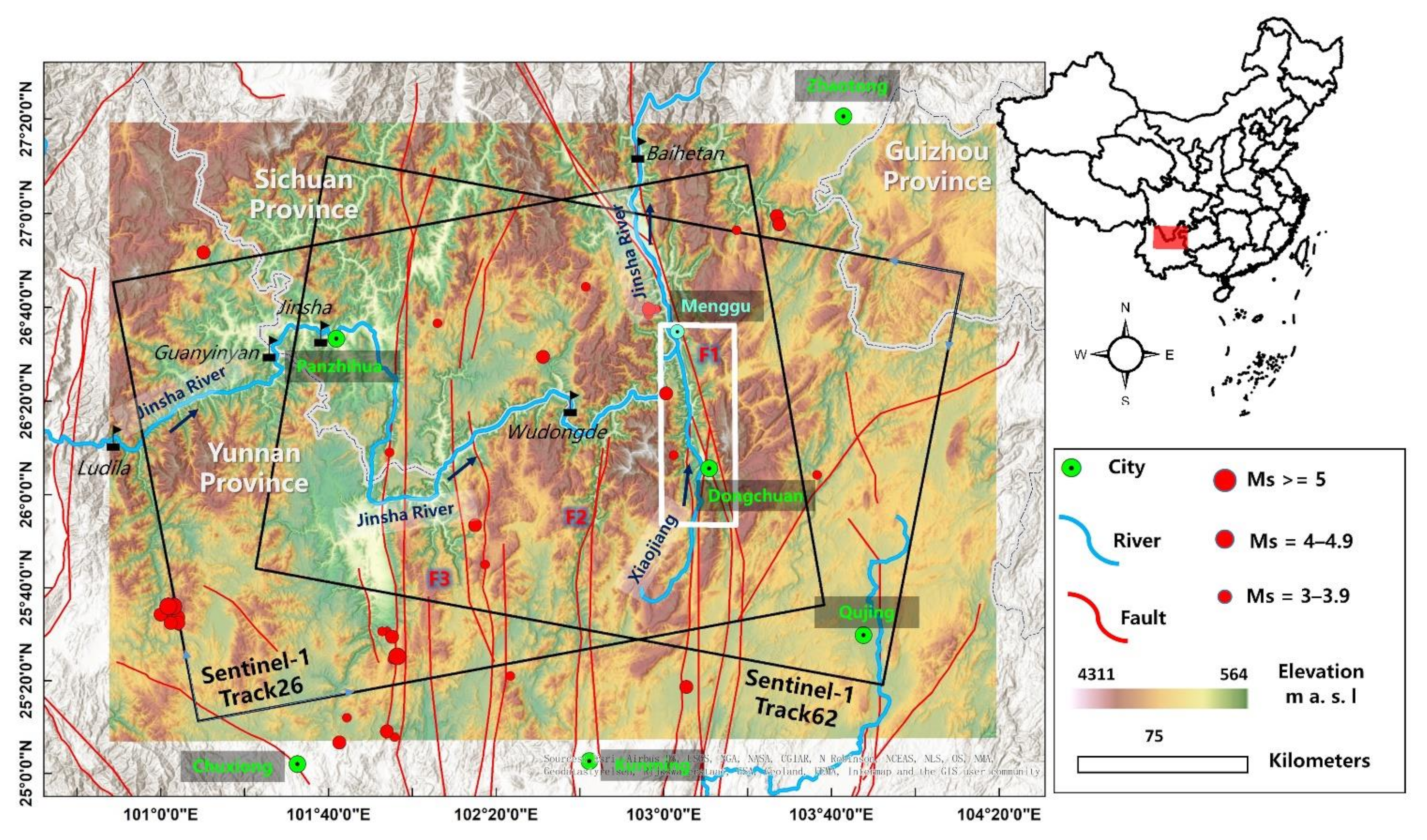
2.1. Study Area
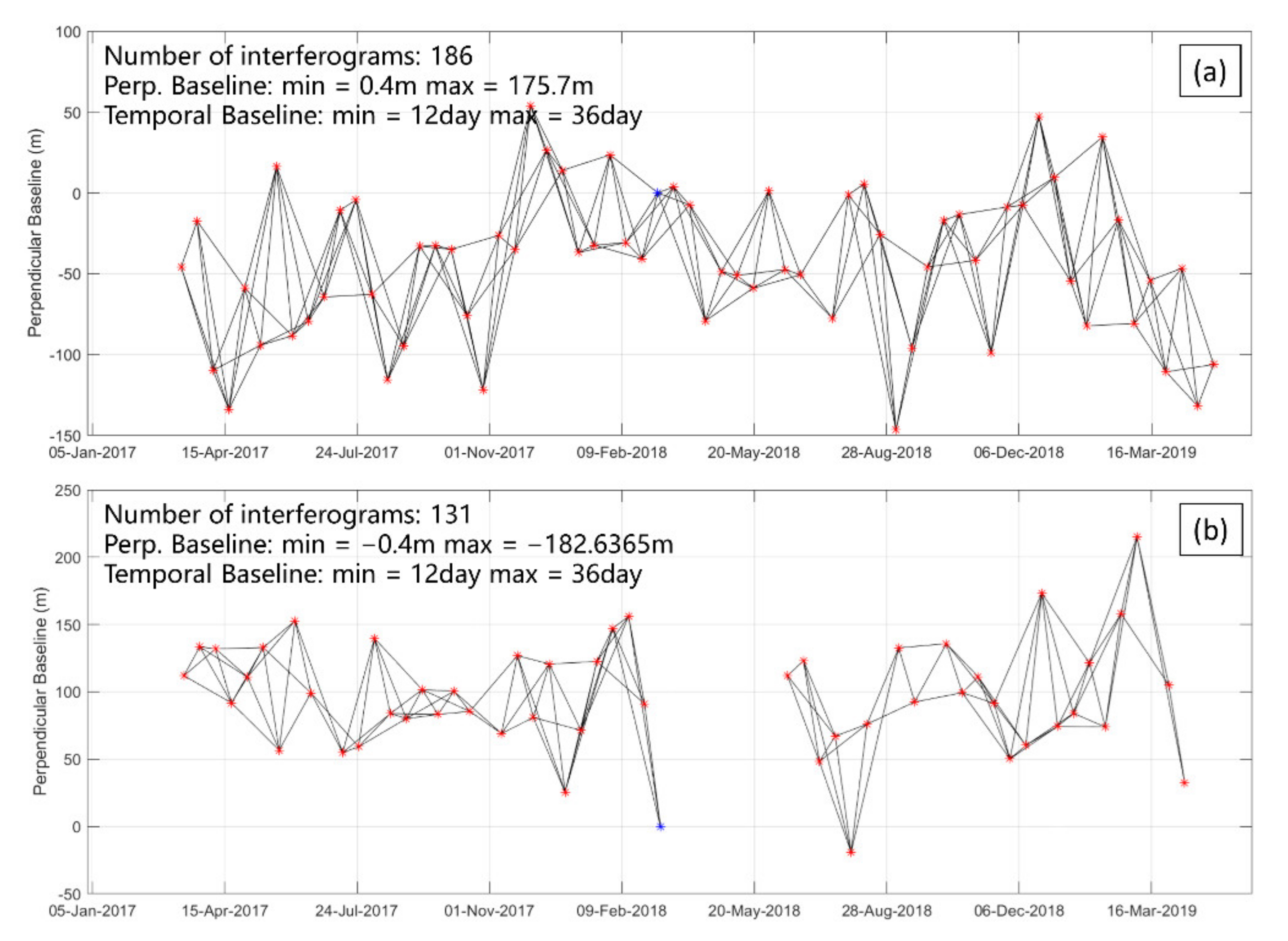
2.2. Datasets
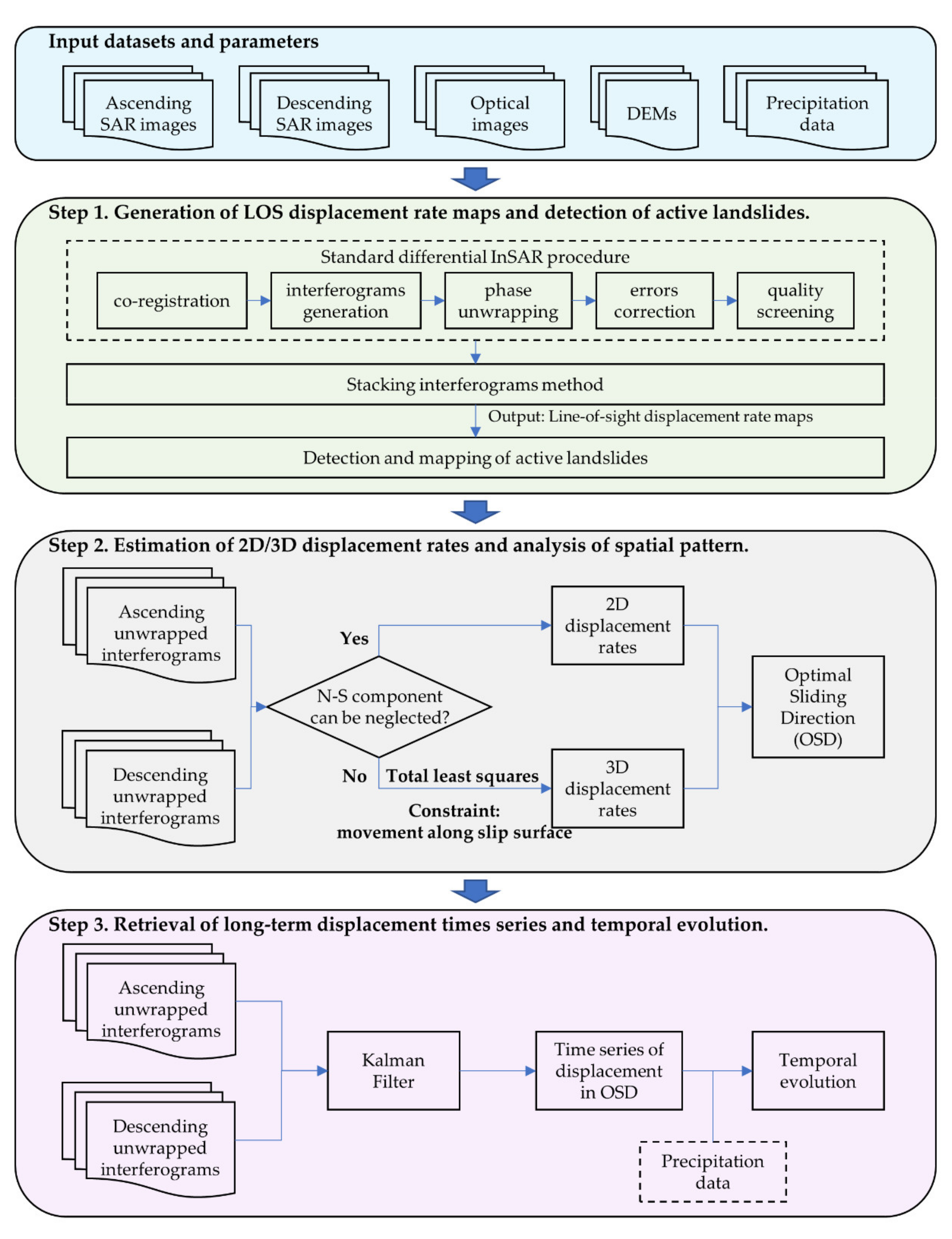
3. Methodology
3.1. InSAR Processing
3.2. Total Least Squares Estimation of Three-Dimensional Landslide Displacement Rates
3.3. Kalman Filter for Long-Term Landslide Displacement Time Series
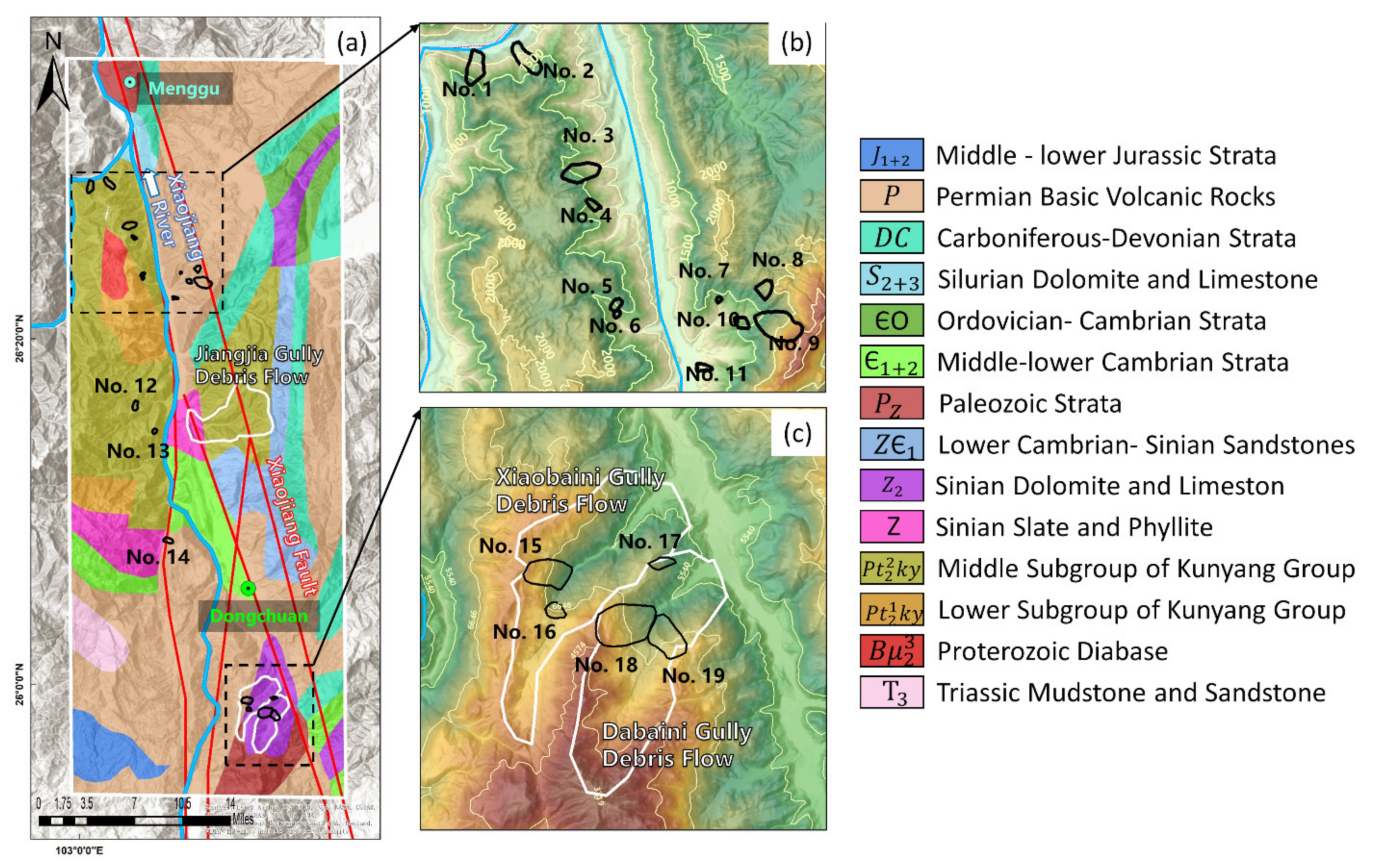
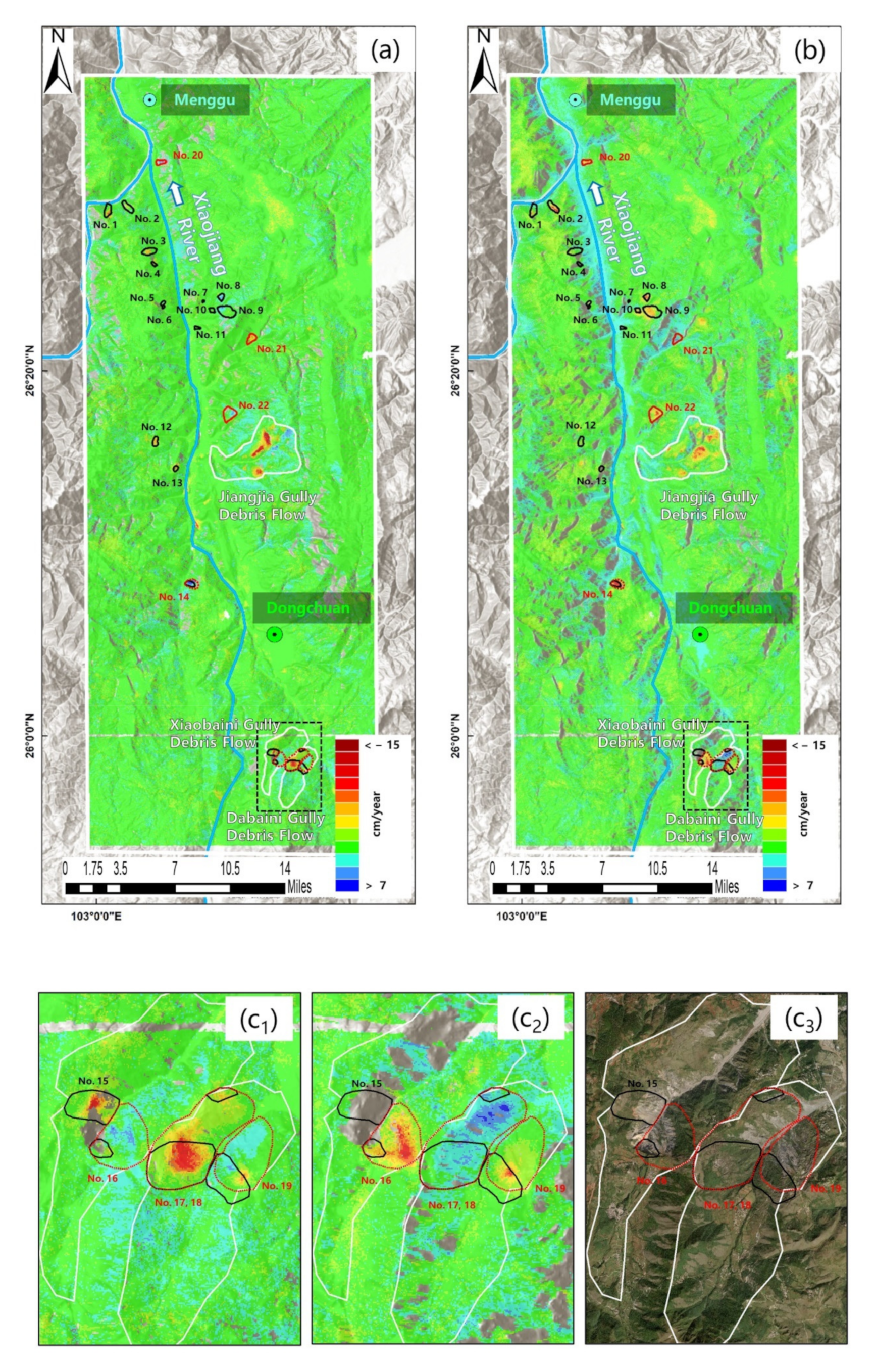
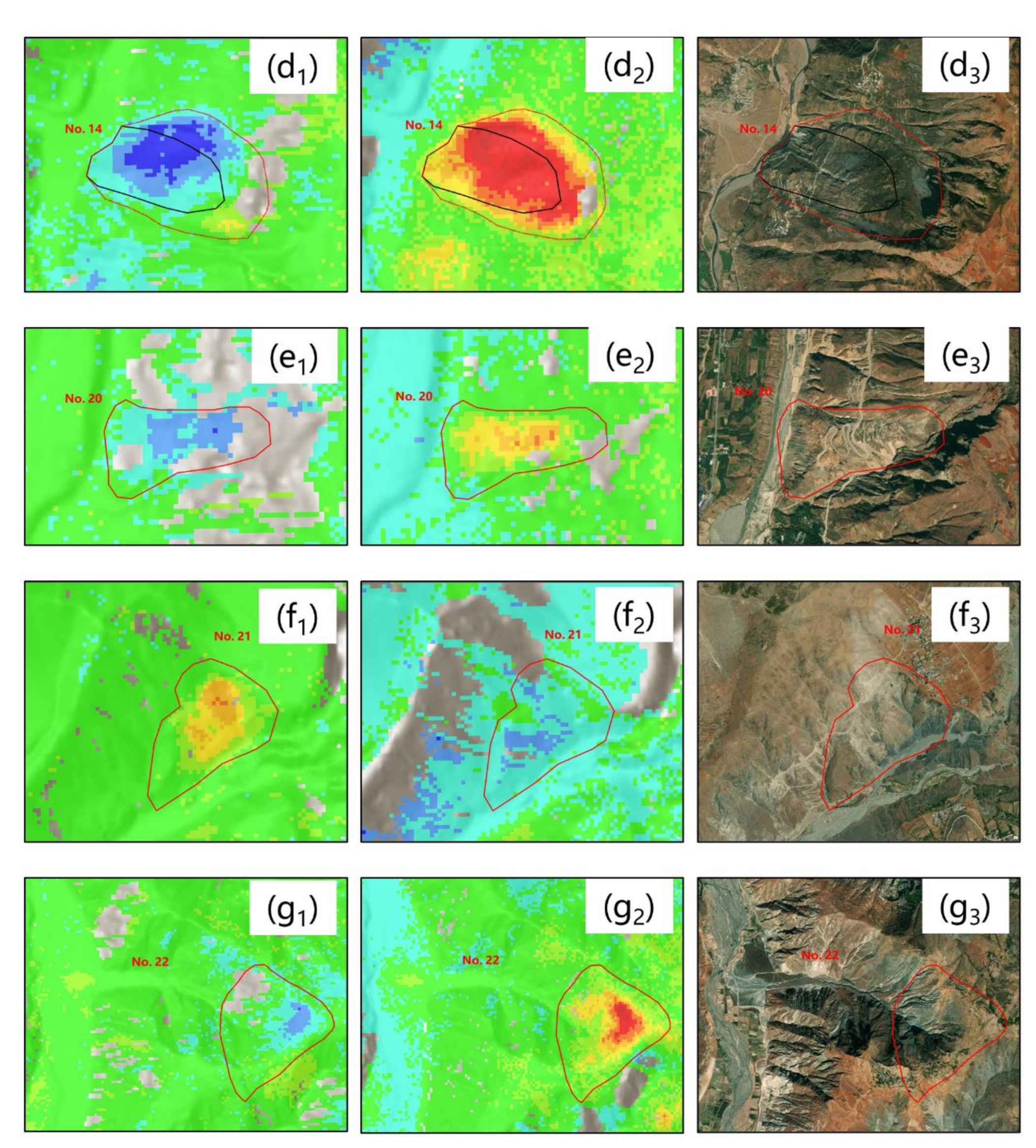
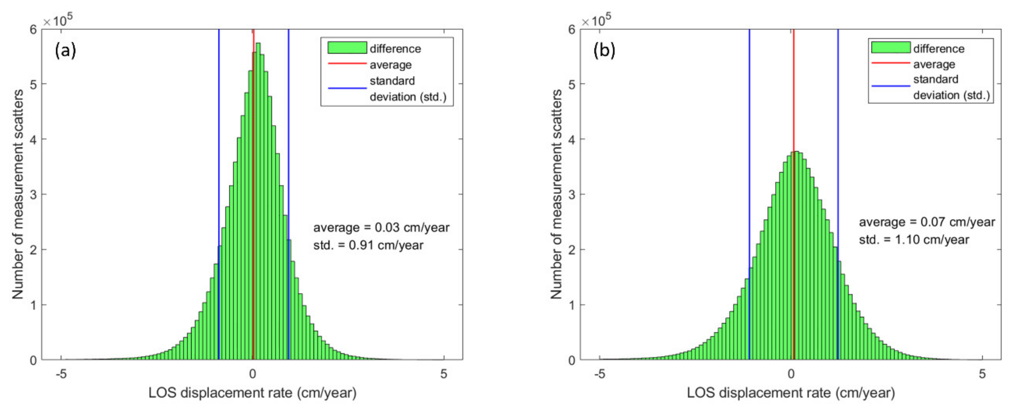
4. Results: Line-of-Sight Displacement Rates between March 2007 to May 2019
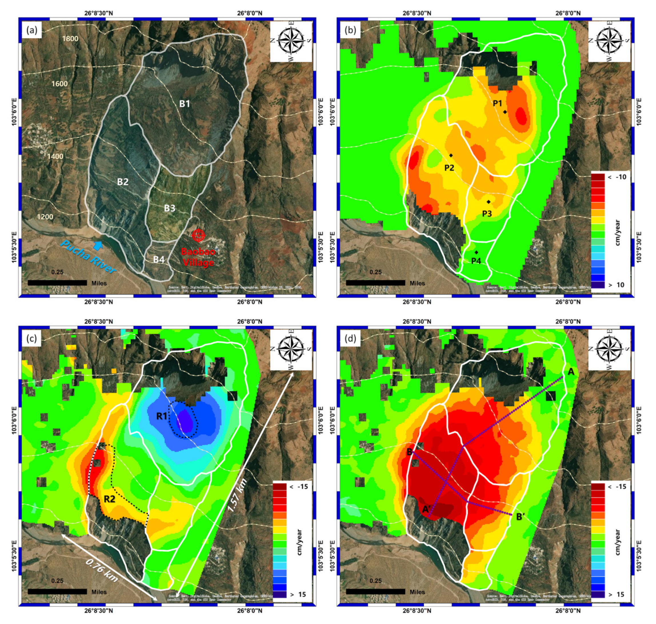
5. Discussion: Three-Dimensional and Long-Term Displacements of Baobao Landslide
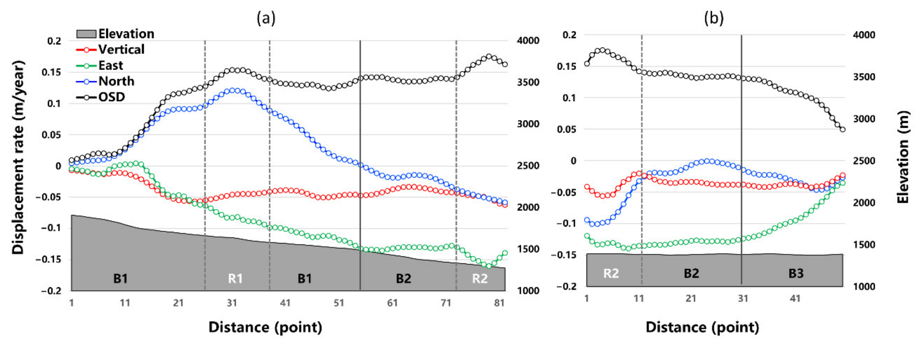
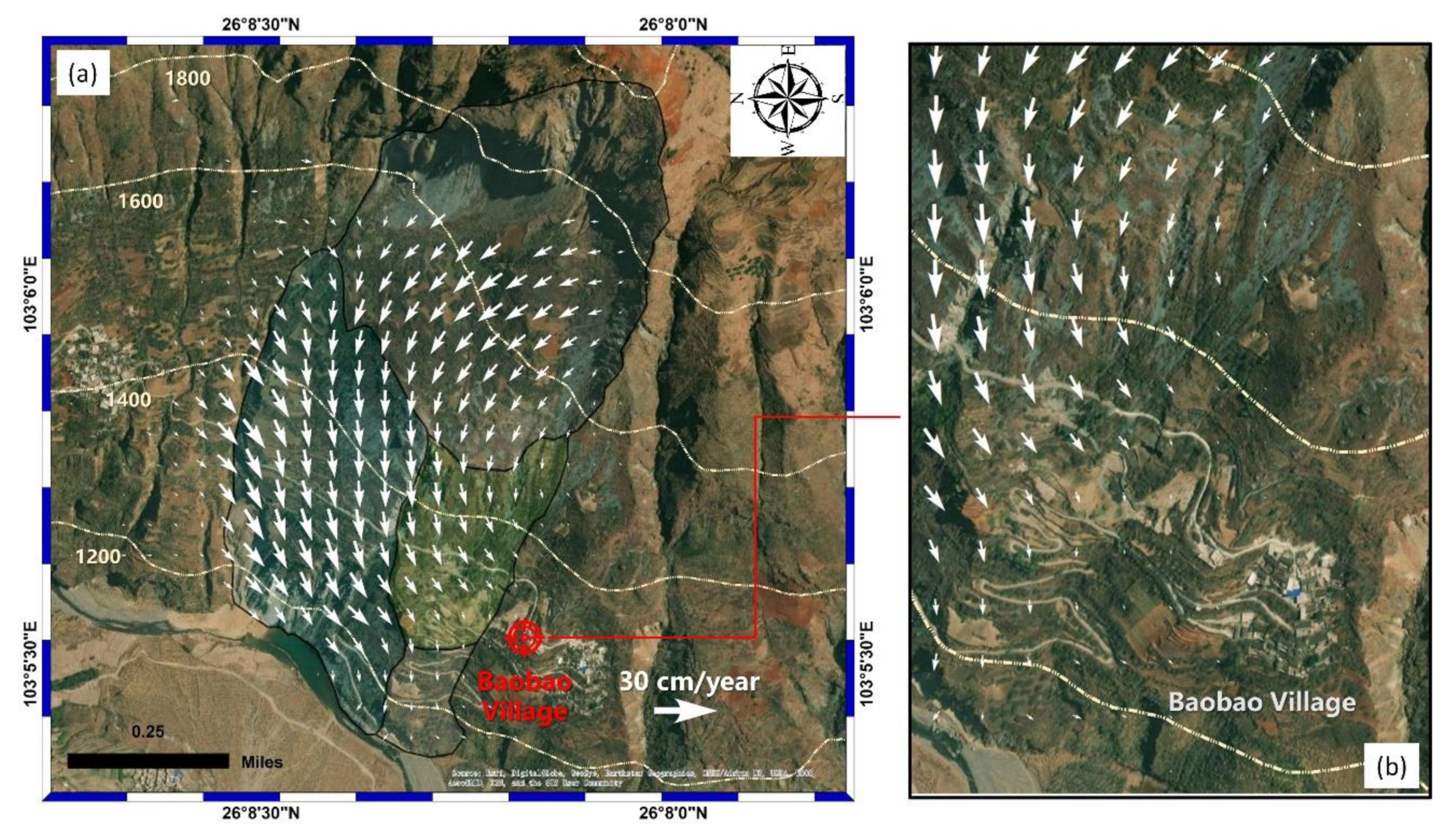
5.1. Three-Dimensional Displacement Rates for Spatial Displacement Pattern Analysis
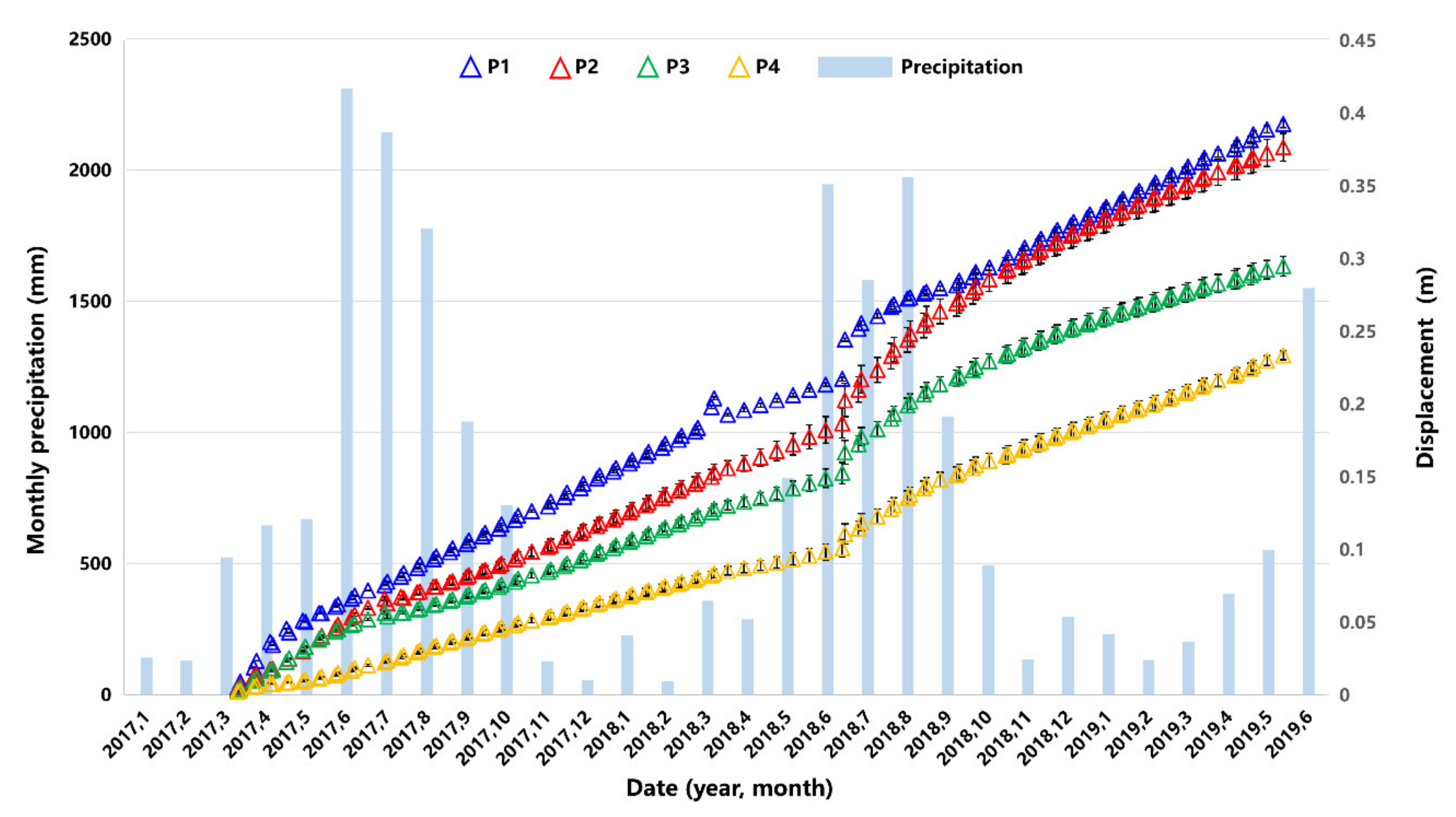
5.2. Long-Term Displacement Time Series for Temporal Displacement Pattern Analysis
6. Conclusions
Author Contributions
Funding
Institutional Review Board Statement
Informed Consent Statement
Data Availability Statement
Acknowledgments
Conflicts of Interest
References
- Necula, N.; Niculiță, M.; Fiaschi, S.; Genevois, R.; Riccardi, P.; Floris, M. Assessing Urban Landslide Dynamics through Multi-Temporal InSAR Techniques and Slope Numerical Modeling. Remote Sens. 2021, 13, 3862. [Google Scholar] [CrossRef] [Scilit]
- Zhu, Y.; Qiu, H.; Liu, Z.; Wang, J.; Yang, D.; Pei, Y.; Ma, S.; Du, C.; Sun, H.; Wang, L. Detecting Long-Term Deformation of a Loess Landslide from the Phase and Amplitude of Satellite SAR Images: A Retrospective Analysis for the Closure of a Tunnel Event. Remote Sens. 2021, 13, 4841. [Google Scholar] [CrossRef] [Scilit]
- Yang, D.; Qiu, H.; Zhu, Y.; Liu, Z.; Pei, Y.; Ma, S.; Du, C.; Sun, H.; Liu, Y.; Cao, M. Landslide Characteristics and Evolution: What We Can Learn from Three Adjacent Landslides. Remote Sens. 2021, 13, 4579. [Google Scholar] [CrossRef] [Scilit]
- Petley, D. Global patterns of loss of life from landslides. Geology 2012, 40, 927–930. [Google Scholar] [CrossRef] [Scilit]
- Froude, M.; Petley, D. Global fatal landslide occurrence from 2004 to 2016. Nat. Hazards Earth Syst. Sci. 2018, 18, 2161–2181. [Google Scholar] [CrossRef] [Scilit]
- Jia, H.; Wang, Y.; Ge, D.; Deng, Y.; Wang, R. Improved Offset Tracking for Predisaster Deformation Monitoring of the 2018 Jinsha River Landslide (Tibet, China). Remote Sens. Environ. 2020, 247, 111899. [Google Scholar] [CrossRef] [Scilit]
- Intrieri, E.; Raspini, F.; Fumagalli, A.; Lu, P.; del Conte, S.; Farina, P.; Allievi, J.; Ferretti, A.; Casagli, N. The Maoxian Landslide as Seen from Space: Detecting Precursors of Failure with Sentinel-1 Data. Landslides 2018, 15, 123–133. [Google Scholar] [CrossRef] [Scilit]
- Dai, K.; Li, Z.; Xu, Q.; Burgmann, R.; Milledge, D.G.; Tomas, R.; Fan, X.; Zhao, C.; Liu, X.; Peng, J.; et al. Entering the Era of Earth Observation-Based Landslide Warning Systems: A Novel and Exciting Framework. IEEE Geosci. Remote Sens. Mag. 2020, 8, 136–153. [Google Scholar] [CrossRef] [Scilit]
- Massonnet, D.; Feigl, K.L. Radar Interferometry and Its Application to Changes in the Earth’s Surface. Rev. Geophys. 1998, 36, 441–500. [Google Scholar] [CrossRef] [Scilit]
- Berardino, P.; Fornaro, G.; Lanari, R.; Sansosti, E. A New Algorithm for Surface Deformation Monitoring Based on Small Baseline Differential SAR Interferograms. IEEE Trans. Geosci. Remote Sens. 2002, 40, 2375–2383. [Google Scholar] [CrossRef] [Scilit]
- Ferretti, A.; Prati, C.; Rocca, F. Permanent Scatterers in SAR Interferometry. IEEE Trans. Geosci. Remote Sens. 2001, 39, 8–20. [Google Scholar] [CrossRef] [Scilit]
- Lyons, S.; Sandwell, D. Fault Creep along the Southern San Andreas from Interferometric Synthetic Aperture Radar, Permanent Scatterers, and Stacking: Southern San Andreas from Insar. J. Geophys. Res. 2003, 108, 108. [Google Scholar] [CrossRef] [Scilit]
- Rosi, A.; Tofani, V.; Tanteri, L.; Tacconi Stefanelli, C.; Agostini, A.; Catani, F.; Casagli, N. The New Landslide Inventory of Tuscany (Italy) Updated with PS-InSAR: Geomorphological Features and Landslide Distribution. Landslides 2018, 15, 5–19. [Google Scholar] [CrossRef] [Scilit]
- Solari, L.; del Soldato, M.; Raspini, F.; Barra, A.; Bianchini, S.; Confuorto, P.; Casagli, N.; Crosetto, M. Review of Satellite Interferometry for Landslide Detection in Italy. Remote Sens. 2020, 12, 1351. [Google Scholar] [CrossRef] [Scilit]
- Schlögel, R.; Doubre, C.; Malet, J.-P.; Masson, F. Landslide Deformation Monitoring with ALOS/PALSAR Imagery: A D-InSAR Geomorphological Interpretation Method. Geomorphology 2015, 231, 314–330. [Google Scholar] [CrossRef] [Scilit]
- Aslan, G.; Foumelis, M.; Raucoules, D.; de Michele, M.; Bernardie, S.; Cakir, Z. Landslide Mapping and Monitoring Using Persistent Scatterer Interferometry (PSI) Technique in the French Alps. Remote Sens. 2020, 12, 1305. [Google Scholar] [CrossRef] [Scilit]
- Zhao, C.; Lu, Z.; Zhang, Q.; de la Fuente, J. Large-Area Landslide Detection and Monitoring with ALOS/PALSAR Imagery Data over Northern California and Southern Oregon, USA. Remote Sens. Environ. 2012, 124, 348–359. [Google Scholar] [CrossRef] [Scilit]
- Zhao, C.; Kang, Y.; Zhang, Q.; Lu, Z.; Li, B. Landslide Identification and Monitoring along the Jinsha River Catchment (Wudongde Reservoir Area), China, Using the InSAR Method. Remote Sens. 2018, 10, 993. [Google Scholar] [CrossRef] [Scilit]
- Liu, X.; Zhao, C.; Zhang, Q.; Lu, Z.; Li, Z.; Yang, C.; Zhu, W.; Liu-Zeng, J.; Chen, L.; Liu, C. Integration of Sentinel-1 and ALOS/PALSAR-2 SAR Datasets for Mapping Active Landslides along the Jinsha River Corridor, China. Eng. Geol. 2021, 284, 106033. [Google Scholar] [CrossRef] [Scilit]
- Novellino, A.; Cigna, F.; Sowter, A.; Ramondini, M.; Calcaterra, D. Exploitation of the Intermittent SBAS (ISBAS) Algorithm with COSMO-SkyMed Data for Landslide Inventory Mapping in North-Western Sicily, Italy. Geomorphology 2017, 280, 153–166. [Google Scholar] [CrossRef] [Scilit]
- Bouali, E.H.; Oommen, T.; Escobar-Wolf, R. Mapping of Slow Landslides on the Palos Verdes Peninsula Using the California Landslide Inventory and Persistent Scatterer Interferometry. Landslides 2018, 15, 439–452. [Google Scholar] [CrossRef] [Scilit]
- Zhang, L.; Dai, K.; Deng, J.; Ge, D.; Liang, R.; Li, W.; Xu, Q. Identifying Potential Landslides by Stacking-InSAR in Southwestern China and Its Performance Comparison with SBAS-InSAR. Remote Sens. 2021, 13, 3662. [Google Scholar] [CrossRef] [Scilit]
- Colesanti, C.; Wasowski, J. Investigating Landslides with Space-Borne Synthetic Aperture Radar (SAR) Interferometry. Eng. Geol. 2006, 88, 173–199. [Google Scholar] [CrossRef] [Scilit]
- Gray, L. Using Multiple RADARSAT InSAR Pairs to Estimate a Full Three-Dimensional Solution for Glacial Ice Movement: Multiple Interferograms for 3-D Motion. Geophys. Res. Lett. 2011, 38, 38. [Google Scholar] [CrossRef] [Scilit]
- Wright, T.J. Toward Mapping Surface Deformation in Three Dimensions Using InSAR. Geophys. Res. Lett. 2004, 31, L01607. [Google Scholar] [CrossRef] [Scilit]
- Fialko, Y.; Sandwell, D.; Simons, M.; Rosen, P. Three-Dimensional Deformation Caused by the Bam, Iran, Earthquake and the Origin of Shallow Slip Deficit. Nature 2005, 435, 295–299. [Google Scholar] [CrossRef] [Scilit]
- Hu, J.; Li, Z.; Zhu, J.; Ren, X.; Ding, X. Inferring Three-Dimensional Surface Displacement Field by Combining SAR Interferometric Phase and Amplitude Information of Ascending and Descending Orbits. Sci. China Earth Sci. 2010, 53, 550–560. [Google Scholar] [CrossRef] [Scilit]
- Jung, H.S.; Lu, Z.; Won, J.S.; Poland, M.P.; Miklius, A. Mapping Three-Dimensional Surface Deformation by Combining Multiple-Aperture Interferometry and Conventional Interferometry: Application to the June 2007 Eruption of Kilauea Volcano, Hawaii. IEEE Geosci. Remote Sensing Lett. 2011, 8, 34–38. [Google Scholar] [CrossRef] [Scilit]
- Hu, J.; Li, Z.W.; Ding, X.L.; Zhu, J.J.; Zhang, L.; Sun, Q. 3D Coseismic Displacement of 2010 Darfield, New Zealand Earthquake Estimated from Multi-Aperture InSAR and D-InSAR Measurements. J. Geod. 2012, 86, 1029–1041. [Google Scholar] [CrossRef] [Scilit]
- Gudmundsson, S.; Sigmundsson, F.; Carstensen, J.M. Three-Dimensional Surface Motion Maps Estimated from Combined Interferometric Synthetic Aperture Radar and GPS Data: THREE-DIMENSIONAL SURFACE MOTION MAPS. J. Geophys. Res. 2002, 107, ETG 13-1–ETG 13-14. [Google Scholar] [CrossRef] [Scilit]
- Ji, P.; Lv, X.; Chen, Q.; Sun, G.; Yao, J. Applying InSAR and GNSS Data to Obtain 3-D Surface Deformations Based on Iterated Almost Unbiased Estimation and Laplacian Smoothness Constraint. IEEE J. Sel. Top. Appl. Earth Obs. Remote Sens. 2021, 14, 337–349. [Google Scholar] [CrossRef] [Scilit]
- Ji, P.; Lv, X.; Yao, J.; Sun, G. A New Method to Obtain 3-D Surface Deformations from InSAR and GNSS Data With Genetic Algorithm and Support Vector Machine. IEEE Geosci. Remote Sens. Lett. 2022, 19, 1–5. [Google Scholar] [CrossRef] [Scilit]
- Dong, L.; Wang, C.; Tang, Y.; Tang, F.; Zhang, H.; Wang, J.; Duan, W. Time Series InSAR Three-Dimensional Displacement Inversion Model of Coal Mining Areas Based on Symmetrical Features of Mining Subsidence. Remote Sens. 2021, 13, 2143. [Google Scholar] [CrossRef] [Scilit]
- Yang, Z.; Li, Z.; Zhu, J.; Feng, G.; Wang, Q.; Hu, J.; Wang, C. Deriving Time-Series Three-Dimensional Displacements of Mining Areas from a Single-Geometry InSAR Dataset. J. Geod. 2018, 92, 529–544. [Google Scholar] [CrossRef] [Scilit]
- Li, Z.W.; Yang, Z.F.; Zhu, J.J.; Hu, J.; Wang, Y.J.; Li, P.X.; Chen, G.L. Retrieving Three-Dimensional Displacement Fields of Mining Areas from a Single InSAR Pair. J. Geod. 2015, 89, 17–32. [Google Scholar] [CrossRef] [Scilit]
- Kumar, V.; Venkataramana, G.; Høgda, K.A. Glacier Surface Velocity Estimation Using SAR Interferometry Technique Applying Ascending and Descending Passes in Himalayas. Int. J. Appl. Earth Obs. Geoinf. 2011, 13, 545–551. [Google Scholar] [CrossRef] [Scilit]
- Sun, Q.; Hu, J.; Zhang, L.; Ding, X. Towards Slow-Moving Landslide Monitoring by Integrating Multi-Sensor InSAR Time Series Datasets: The Zhouqu Case Study, China. Remote Sens. 2016, 8, 908. [Google Scholar] [CrossRef] [Scilit]
- Hu, X.; Bürgmann, R.; Fielding, E.J.; Lee, H. Internal Kinematics of the Slumgullion Landslide (USA) from High-Resolution UAVSAR InSAR Data. Remote Sens. Environ. 2020, 251, 112057. [Google Scholar] [CrossRef] [Scilit]
- Ao, M.; Zhang, L.; Shi, X.; Liao, M.; Dong, J. Measurement of the Three-Dimensional Surface Deformation of the Jiaju Landslide Using a Surface-Parallel Flow Model. Remote Sens. Lett. 2019, 10, 776–785. [Google Scholar] [CrossRef] [Scilit]
- Samsonov, S.; Dille, A.; Dewitte, O.; Kervyn, F.; d’Oreye, N. Satellite Interferometry for Mapping Surface Deformation Time Series in One, Two and Three Dimensions: A New Method Illustrated on a Slow-Moving Landslide. Eng. Geol. 2020, 266, 105471. [Google Scholar] [CrossRef] [Scilit]
- Liu, X.; Zhao, C.; Zhang, Q.; Yin, Y.; Lu, Z.; Samsonov, S.; Yang, C.; Wang, M.; Tomás, R. Three-Dimensional and Long-Term Landslide Displacement Estimation by Fusing C- and L-Band SAR Observations: A Case Study in Gongjue County, Tibet, China. Remote Sens. Environ. 2021, 267, 112745. [Google Scholar] [CrossRef] [Scilit]
- Aydan, Ö.; Ito, T.; Özbay, U.; Kwasniewski, M.; Shariar, K.; Okuno, T.; Özgenoğlu, A.; Malan, D.F.; Okada, T. ISRM Suggested Methods for Determining the Creep Characteristics of Rock. Rock Mech. Rock Eng. 2014, 47, 275–290. [Google Scholar] [CrossRef] [Scilit]
- Wasowski, J.; Bovenga, F. Investigating Landslides and Unstable Slopes with Satellite Multi Temporal Interferometry: Current Issues and Future Perspectives. Eng. Geol. 2014, 174, 103–138. [Google Scholar] [CrossRef] [Scilit]
- Intrieri, E.; Carlà, T.; Gigli, G. Forecasting the Time of Failure of Landslides at Slope-Scale: A Literature Review. Earth-Sci. Rev. 2019, 193, 333–349. [Google Scholar] [CrossRef] [Scilit]
- Casu, F.; Manconi, A.; Pepe, A.; Lanari, R. Deformation Time-Series Generation in Areas Characterized by Large Displacement Dynamics: The SAR Amplitude Pixel-Offset SBAS Technique. IEEE Trans. Geosci. Remote Sens. 2011, 49, 2752–2763. [Google Scholar] [CrossRef] [Scilit]
- Samsonov, S.; d’Oreye, N. Multidimensional time-series analysis of ground deformation from multiple insar data sets applied to virunga volcanic province. Geophys. J. Int. 2012, 191, 1095–1108. [Google Scholar]
- Pepe, A.; Solaro, G.; Calo, F.; Dema, C. A Minimum Acceleration Approach for the Retrieval of Multiplatform InSAR Deformation Time Series. IEEE J. Sel. Top. Appl. Earth Obs. Remote Sens. 2016, 9, 3883–3898. [Google Scholar] [CrossRef] [Scilit]
- Hu, J.; Ding, X.-L.; Li, Z.-W.; Zhu, J.-J.; Sun, Q.; Zhang, L. Kalman-Filter-Based Approach for Multisensor, Multitrack, and Multitemporal InSAR. IEEE Trans. Geosci. Remote Sens. 2013, 51, 4226–4239. [Google Scholar] [CrossRef]
- Dalaison, M.; Jolivet, R. A Kalman Filter Time Series Analysis Method for InSAR. J. Geophys. Res. Solid Earth 2020, 125, 125. [Google Scholar] [CrossRef] [Scilit]
- Zhang, X.; Gan, S.; Yuan, X.; Wang, L.; Yang, M.; Chen, X. Analysis of land use patterns of debris flow fans in Xiaojiang River Basin of Yunnan Province. J. Yunnan Univ. Nat. Sci. Ed. 2020, 42, 499–506. [Google Scholar] [CrossRef]
- Wu, J.; Zeng, Y. Xiaojiang River Basin: Natural Museum of Landslides. Hum. Nat. 2002, 4, 21–25. [Google Scholar]
- Guo, C.; Montgomery, D.R.; Zhang, Y.; Wang, K.; Yang, Z. Quantitative Assessment of Landslide Susceptibility along the Xianshuihe Fault Zone, Tibetan Plateau, China. Geomorphology 2015, 248, 93–110. [Google Scholar] [CrossRef] [Scilit]
- Yang, J.; Li, Y.; Yun, N.; Zhou, S.; Yang, H.; Yang, Z.; Yao, Y. Dynamic earthquake trig-gering in the north of Xiaojiang fault zone, Yunnan. Chin. J. Geophys. 2021, 64, 3207–3219. (In Chinese) [Google Scholar] [CrossRef]
- Zhao, X. Study on the Risk Assessment of Landslide Hazards in Northeastern Yunnan Province. Master’s Thesis, Yunnan University, Kunming, China, 2018. Available online: https://kns.cnki.net/kcms/detail/detail.aspx?FileName=1018248736.nh&DbName=CMFD2020 (accessed on 1 May 2018). (In Chinese)
- Zhao, N.; Wang, Z.; Pan, B.; Li, Z.; Daun, X. Ecological Functions of Riverbed Structures with Different Strengths in the Xiaojiang River Basin. J. Tsinghua Univ. Sci. Technol. 2015, 54, 584–589. [Google Scholar]
- Zhou, D.; Zuo, X. Surface subsidence monitoring and prediction in mining area based on SBAS-InSAR and PSO-BP neural network algorithm. J. Yunnan Univ. Nat. Sci. Ed. 2021, 43, 895–905. [Google Scholar] [CrossRef]
- Dun, J.; Feng, W.; Yi, X.; Zhang, G.; Wu, M. Detection and Mapping of Active Landslides before Impoundment in the Baihetan Reservoir Area (China) Based on the Time-Series InSAR Method. Remote Sens. 2021, 13, 3213. [Google Scholar] [CrossRef] [Scilit]
- Gourmelen, N.; Kim, S.W.; Shepherd, A.; Park, J.W.; Sundal, A.V.; Björnsson, H.; Pálsson, F. Ice Velocity Determined Using Conventional and Multiple-Aperture InSAR. Earth Planet. Sci. Lett. 2011, 307, 156–160. [Google Scholar] [CrossRef] [Scilit]
- Cascini, L.; Fornaro, G.; Peduto, D. Advanced Low- and Full-Resolution DInSAR Map Generation for Slow-Moving Landslide Analysis at Different Scales. Eng. Geol. 2010, 112, 29–42. [Google Scholar] [CrossRef] [Scilit]
- Wang, Y.; Liu, D.; Dong, J.; Zhang, L.; Guo, J.; Liao, M.; Gong, J. On the Applicability of Satellite SAR Interferometry to Landslide Hazards Detection in Hilly Areas: A Case Study of Shuicheng, Guizhou in Southwest China. Landslides 2021, 18, 2609–2619. [Google Scholar] [CrossRef] [Scilit]
- Costantini, M. A Novel Phase Unwrapping Method Based on Network Programming. IEEE Trans. Geosci. Remote Sens. 1998, 36, 813–821. [Google Scholar] [CrossRef] [Scilit]
- Liao, M.; Zhang, L.; Shi, X.; Jiang, Y.; Dong, J.; Liu, Y. Radar Remote Sensing Monitoring Methods and Practices of Landslide Deformation; Science Press: Beijing, China, 2017. [Google Scholar]
- Zhao, C.; Zhang, Q.; He, Y.; Peng, J.; Yang, C.; Kang, Y. Small-Scale Loess Landslide Monitoring with Small Baseline Subsets Interferometric Synthetic Aperture Radar Technique—Case Study of Xingyuan Landslide, Shaanxi, China. J. Appl. Remote Sens. 2016, 10, 026030. [Google Scholar] [CrossRef] [Scilit]
- Bekaert, D.P.S.; Hooper, A.; Wright, T.J. A Spatially Variable Power Law Tropospheric Correction Technique for InSAR Data. J. Geophys. Res. Solid Earth 2015, 120, 1345–1356. [Google Scholar] [CrossRef] [Scilit]
- Biggs, J.; Wright, T.; Lu, Z.; Parsons, B. Multi-Interferogram Method for Measuring Interseismic Deformation: Denali Fault, Alaska. Geophys. J. Int. 2007, 170, 1165–1179. [Google Scholar] [CrossRef] [Scilit]
- Frattini, P.; Crosta, G.B.; Rossini, M.; Allievi, J. Activity and Kinematic Behaviour of Deep-Seated Landslides from PS-InSAR Displacement Rate Measurements. Landslides 2018, 15, 1053–1070. [Google Scholar] [CrossRef] [Scilit]
- Aryal, A.; Brooks, B.A.; Reid, M.E. Landslide Subsurface Slip Geometry Inferred from 3-D Surface Displacement Fields. Geophys. Res. Lett. 2015, 42, 1411–1417. [Google Scholar] [CrossRef] [Scilit]
- Rezaei, S.; Shooshpasha, I.; Rezaei, H. Reconstruction of Landslide Model from ERT, Geotechnical, and Field Data, Nargeschal Landslide, Iran. Bull. Eng. Geol. Environ. 2019, 78, 3223–3237. [Google Scholar] [CrossRef] [Scilit]
- Wang, B.; Li, J.; Liu, C.; Yu, J. Generalized Total Least Squares Prediction Algorithm for Universal 3D Similarity Transformation. Adv. Space Res. 2017, 59, 815–823. [Google Scholar] [CrossRef] [Scilit]
- Schaffrin, B.; Wieser, A. On Weighted Total Least-Squares Adjustment for Linear Regression. J. Geod. 2008, 82, 415–421. [Google Scholar] [CrossRef] [Scilit]
- Sage, A.P.; Husa, G.W. Adaptive filtering with unknown prior statistics. In Proceedings of the Joint Automatic Control Conference, Boulder, CO, USA, 5–7 August 1969; Volume 7, pp. 760–769. [Google Scholar]
- Welch, G.; Gary, B. An Introduction to the Kalman Filter; University of North Carolina at Chapel Hill: Chapel Hill, NC, USA, 1995; pp. 127–132. Available online: https://www.cs.unc.edu/~welch/media/pdf/kalman_intro.pdf (accessed on 24 July 2006).
- Lu, Y. Deformation and Failure Mechanism of Slope in Three Dimensions. J. Rock Mech. Geotech. Eng. 2015, 7, 109–119. [Google Scholar] [CrossRef] [Scilit]



| Sensors | Track | Orbit | Heading (°) | Incidence Angle (°) | Start Date | End Date | No. of Images |
|---|---|---|---|---|---|---|---|
| Sentinel-1 | 26 | Ascending | −12.5209 | 39.6503 | 13 March 2017 | 07 May 2019 | 65 |
| Sentinel-1 | 62 | Descending | 192.5259 | 39.6933 | 15 March 2017 | 10 April 2019 | 52 |
| ; |
| Step 2: |
| Step 3: Repeat Step 2 until |
| Time update (“predict”): |
| Measurement update (“correct”): |
| No. | Location Name | Aspect | Slope (°) | Area (ha) | Scale | Detected from SAR Images | Risk Level | Threat Object |
|---|---|---|---|---|---|---|---|---|
| 1 | West of Xiaoyanjiao | N, NE | 14–49 | 70 | Super large | S1A, S1D | Medium | Roads, Jinsha River |
| 2 | East of Xiaoyanjiao | N, NW | 17–52 | 71 | Super large | S1A, S1D | Medium | Roads, Jinsha River |
| 3 | lijialiangzi | NW | 12–48 | 82 | Super large | S1A | Medium | Villages on back edge, farmlands, roads | debris flow source |
| 4 | Laoliukou | SE | 32–46 | 14 | Large | S1A | Medium | Roads on back edge, buildings, farmlands and roads in gully |
| 5 | Qingmen No.1 | SW | 23–47 | 15 | Large | S1D | High | Villages and roads on back edge |
| 6 | Qingmen No.2 | SW | 22–39 | 6 | Large | S1D | Medium | Farmlands on back edge |
| 7 | Bainijing | SW | 24–39 | 3 | Medium | S1A, S1D | Low | Debris flow source |
| 8 | Dingjiabaob-ao | SW, W | 6–35 | 31 | Large | S1A, S1D | Medium | Farmlands, and roads |
| 9 | Songpingzi | NW | 12–59 | 159 | Super large | S1A, S1D | High | Villages, farmlands, and roads |
| 10 | Laoqing Gully | N | 28–41 | 20 | Large | S1D | Medium | Farmlands on back edge |
| 11 | Taiping Village | W | 18–38 | 14 | Large | Medium | Farmlands, and roads | |
| 12 | Pingzi Village | N | 8–41 | 45 | Large | S1A | Medium | Farmlands on back edge, roads in gully |
| 13 | Wujiawan | E | 16–43 | 20 | Large | S1A | Medium | Roads |
| 14 | Baobao Village | NW | 17–47 | 140 | Super large | S1A, S1D | Medium | Villages, and roads |
| 15 | Heinaoke | SE | 13–51 | 67 | Super large | S1A | Medium | Farmlands on back edge, buildings, roads, and bridges in gully | debris flow source |
| 16 | Jilongao | NW, N | 9–49 | 167 | Super large | S1A, S1D | Medium | Farmlands |
| 17 | Sanjiacun-Xiaogouqing | E, SE | 8–41 | 275 | Super large | S1A, S1D | High | Buildings, roads, bridges and farmlands in gully | debris flow source |
| 18 | ||||||||
| 19 | Lanshanao | NW | 9–36 | 175 | Super large | S1A, S1D | Medium | Roads, farmland | debris flow source |
| 20 | Gelepingzi | W | 6–56 | 38 | Large | S1A, S1D | Medium | Roads |
| 21 | Dongfangho-ng Gully | SE | 6–52 | 62 | Super large | S1A | High | Roads, farmlands, and buildings in gully | debris flow source |
| 22 | Laoao Gully | W, SW | 6–45 | 134 | Super large | S1A. S1D | Low | Debris flow source |
Publisher’s Note: MDPI stays neutral with regard to jurisdictional claims in published maps and institutional affiliations. |
© 2022 by the authors. Licensee MDPI, Basel, Switzerland. This article is an open access article distributed under the terms and conditions of the Creative Commons Attribution (CC BY) license (https://creativecommons.org/licenses/by/4.0/).
Share and Cite
Jia, H.; Wang, Y.; Ge, D.; Deng, Y.; Wang, R. InSAR Study of Landslides: Early Detection, Three-Dimensional, and Long-Term Surface Displacement Estimation—A Case of Xiaojiang River Basin, China. Remote Sens. 2022, 14, 1759. https://doi.org/10.3390/rs14071759
Jia H, Wang Y, Ge D, Deng Y, Wang R. InSAR Study of Landslides: Early Detection, Three-Dimensional, and Long-Term Surface Displacement Estimation—A Case of Xiaojiang River Basin, China. Remote Sensing. 2022; 14(7):1759. https://doi.org/10.3390/rs14071759
Chicago/Turabian StyleJia, Hongying, Yingjie Wang, Daqing Ge, Yunkai Deng, and Robert Wang. 2022. "InSAR Study of Landslides: Early Detection, Three-Dimensional, and Long-Term Surface Displacement Estimation—A Case of Xiaojiang River Basin, China" Remote Sensing 14, no. 7: 1759. https://doi.org/10.3390/rs14071759
APA StyleJia, H., Wang, Y., Ge, D., Deng, Y., & Wang, R. (2022). InSAR Study of Landslides: Early Detection, Three-Dimensional, and Long-Term Surface Displacement Estimation—A Case of Xiaojiang River Basin, China. Remote Sensing, 14(7), 1759. https://doi.org/10.3390/rs14071759