
Advancements of Geodetic Activities in Nepal: A Review on Pre- and Post-2015 Gorkha Earthquake Eras with Future Directions


Abstract
1. Background
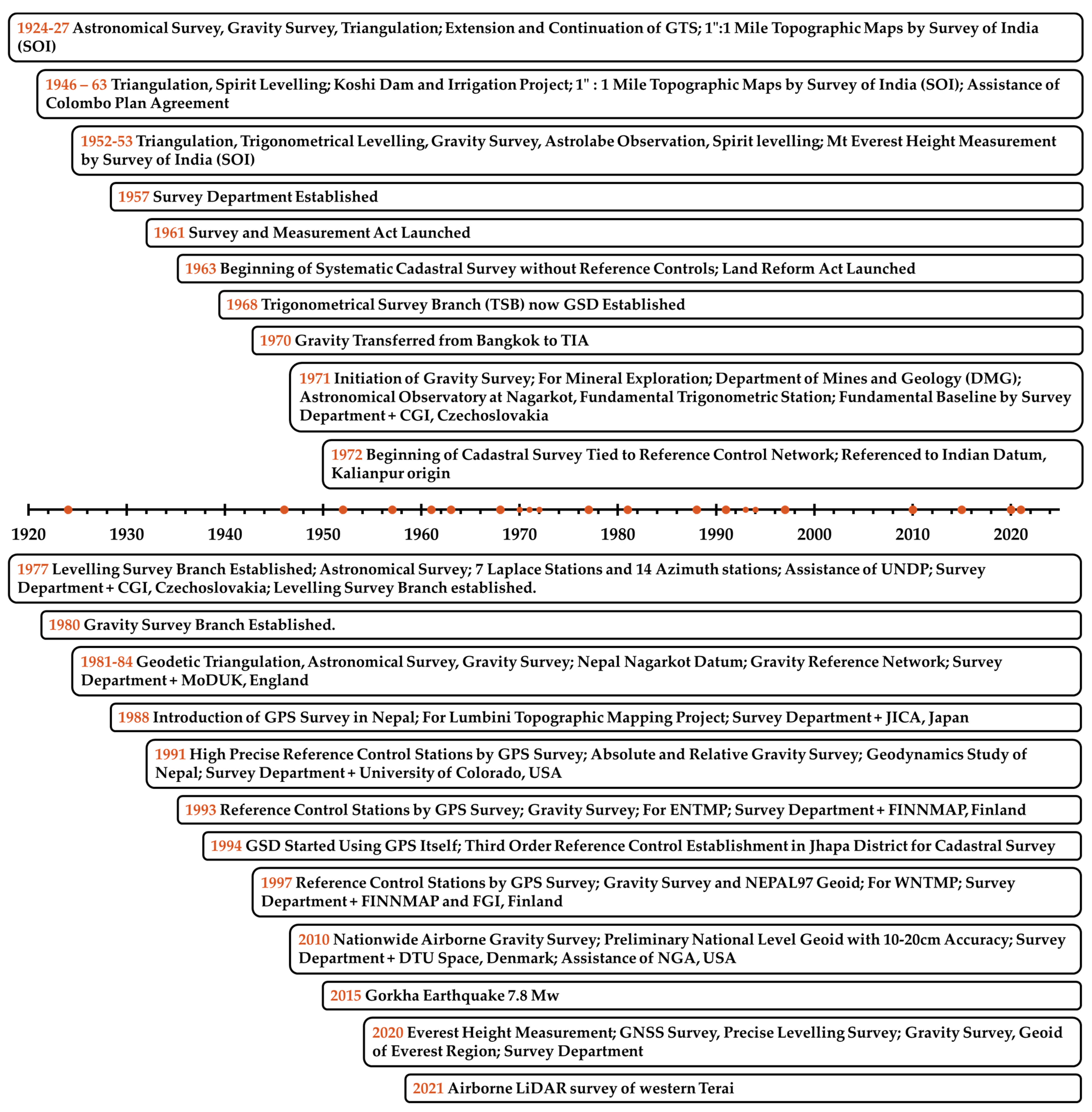
2. Geodesy in Nepal
2.1. Pre 2015 Gorkha Earthquake Era
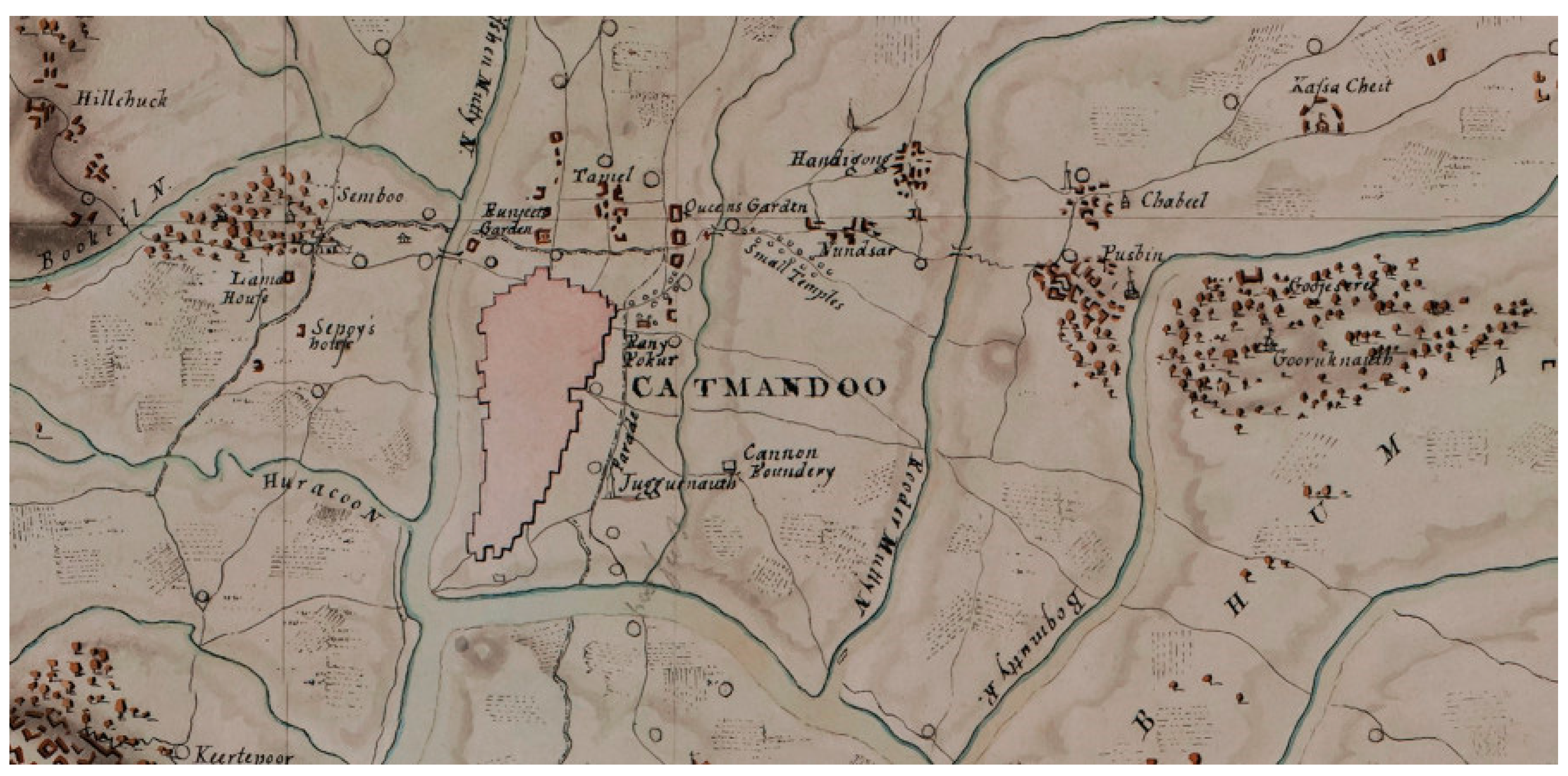
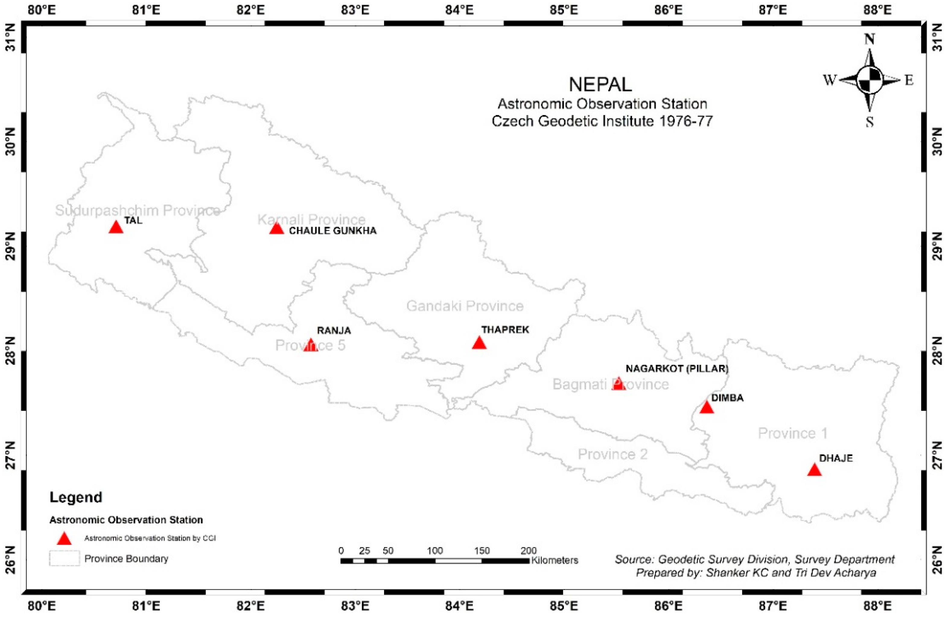
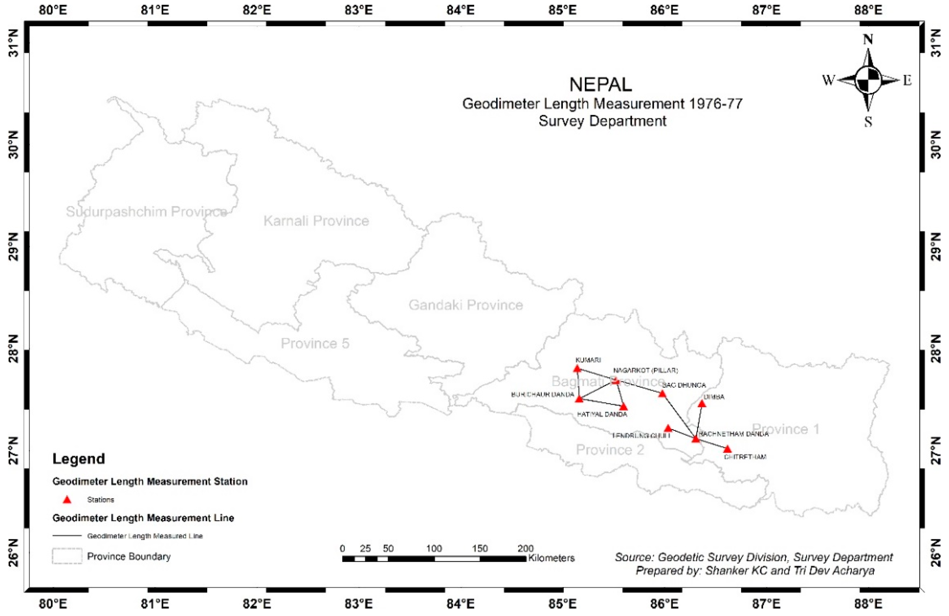
2.1.1. Geodesy at Primitive Time
2.1.2. Topographic Map Series 1” = 1 Mile
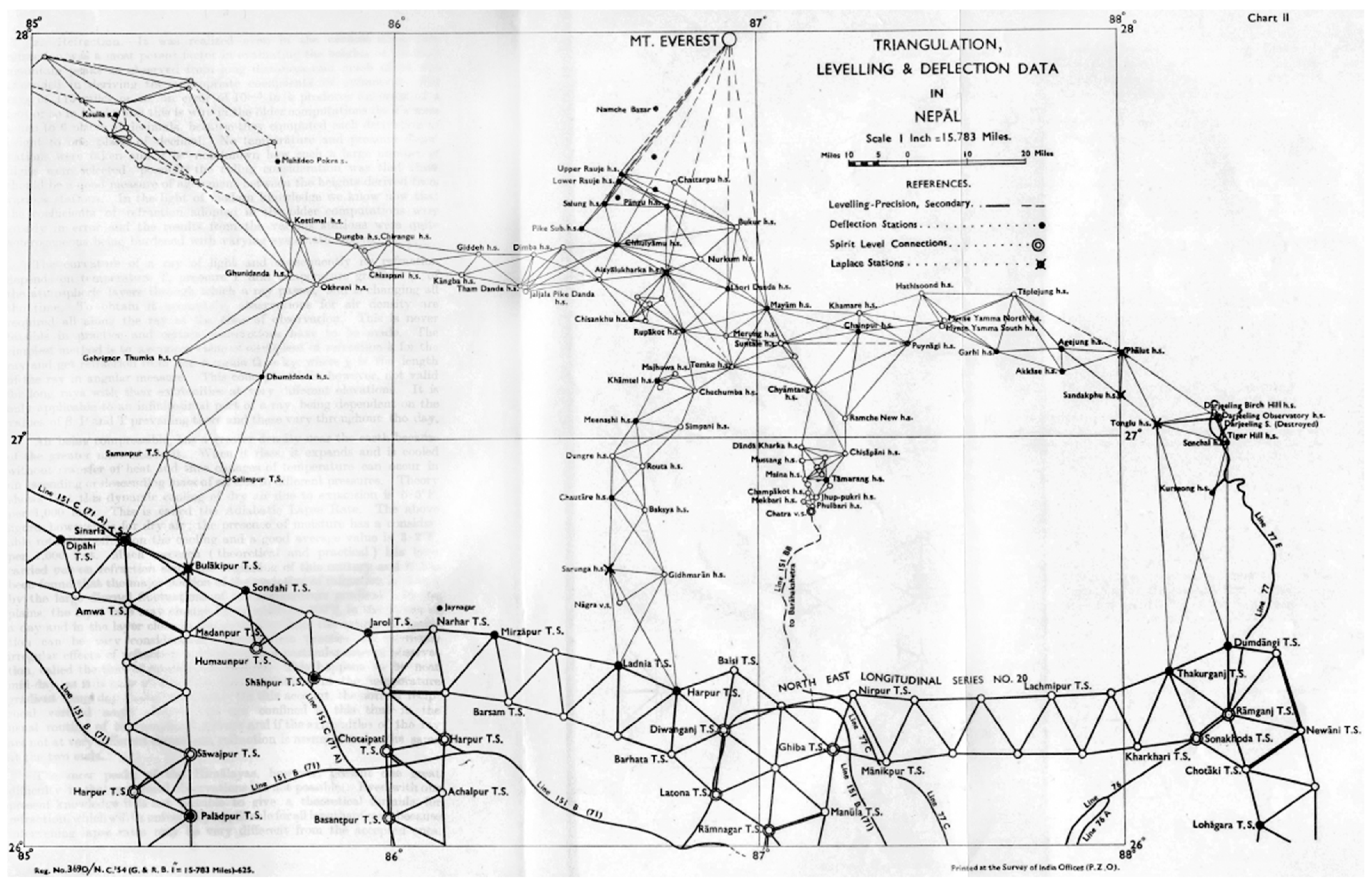
2.1.3. Everest Height Measurement (1952–1954)
2.1.4. Nepal-India, Nepal-China Boundary Survey
2.1.5. Initiation of Nationwide Cadaster Preparation
2.1.6. Establishment of Triangulation Survey Branch (TSB)
2.1.7. Nepal Datum
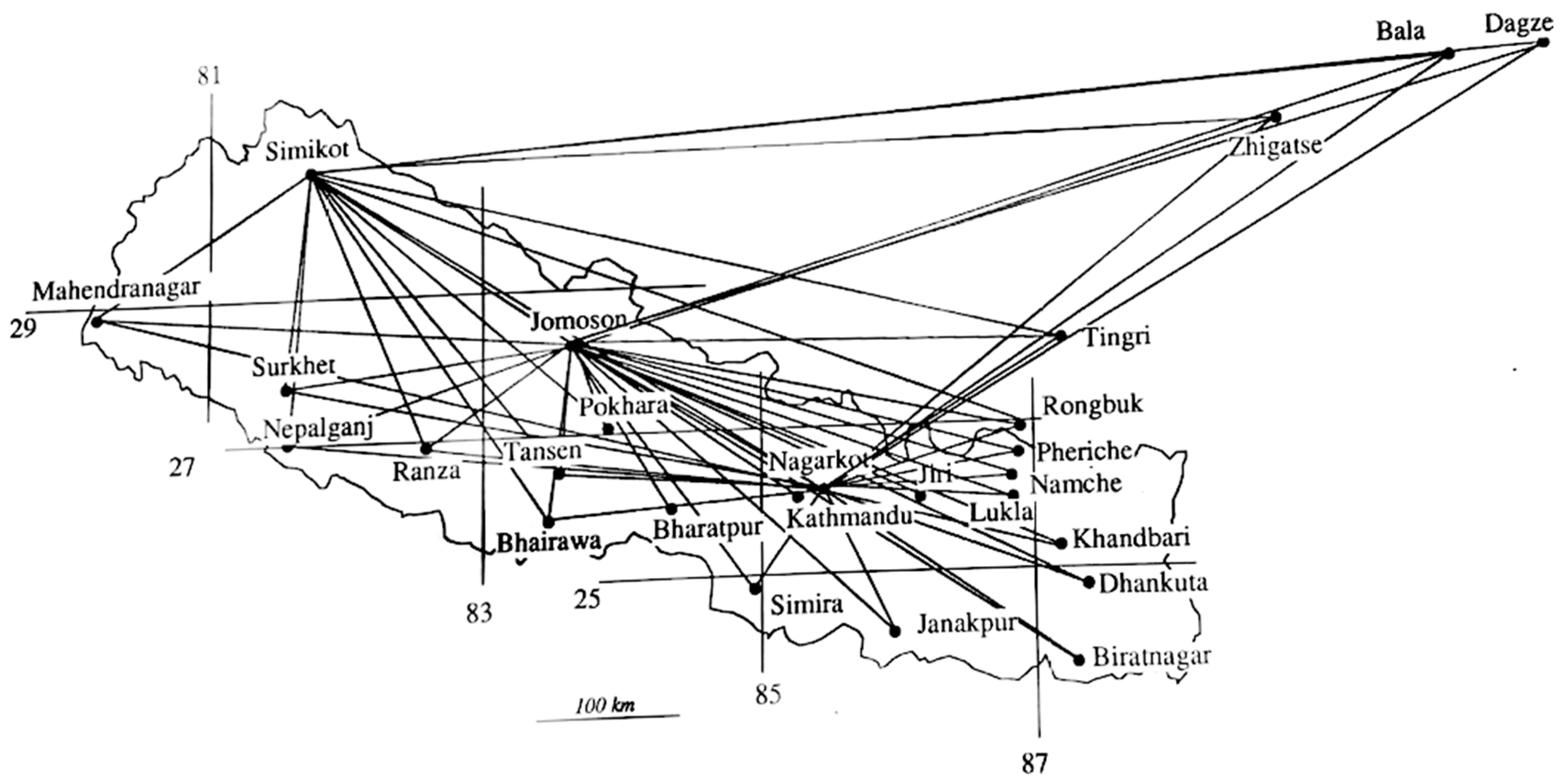
2.1.8. Global Positioning System (GPS) in Nepal
2.1.9. Geodynamics Study of Nepal
2.1.10. Seasonal Deformation Studies over Nepal and Himalaya
2.1.11. Groundwater Resource Monitoring Using Space Geodetic Observations from CORS and GRACE
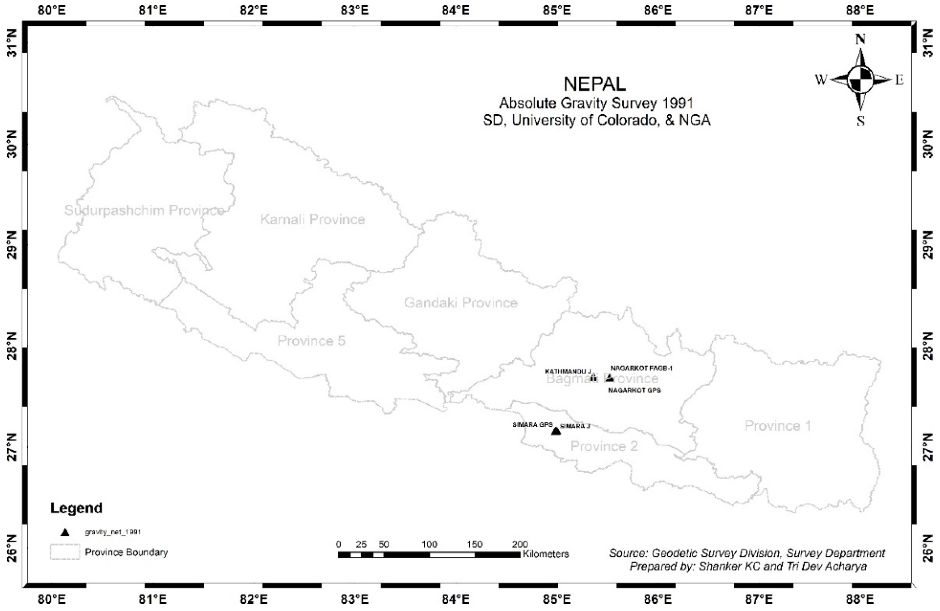
2.1.12. Details of 1991 GPS Survey by SD and CU at Boulder
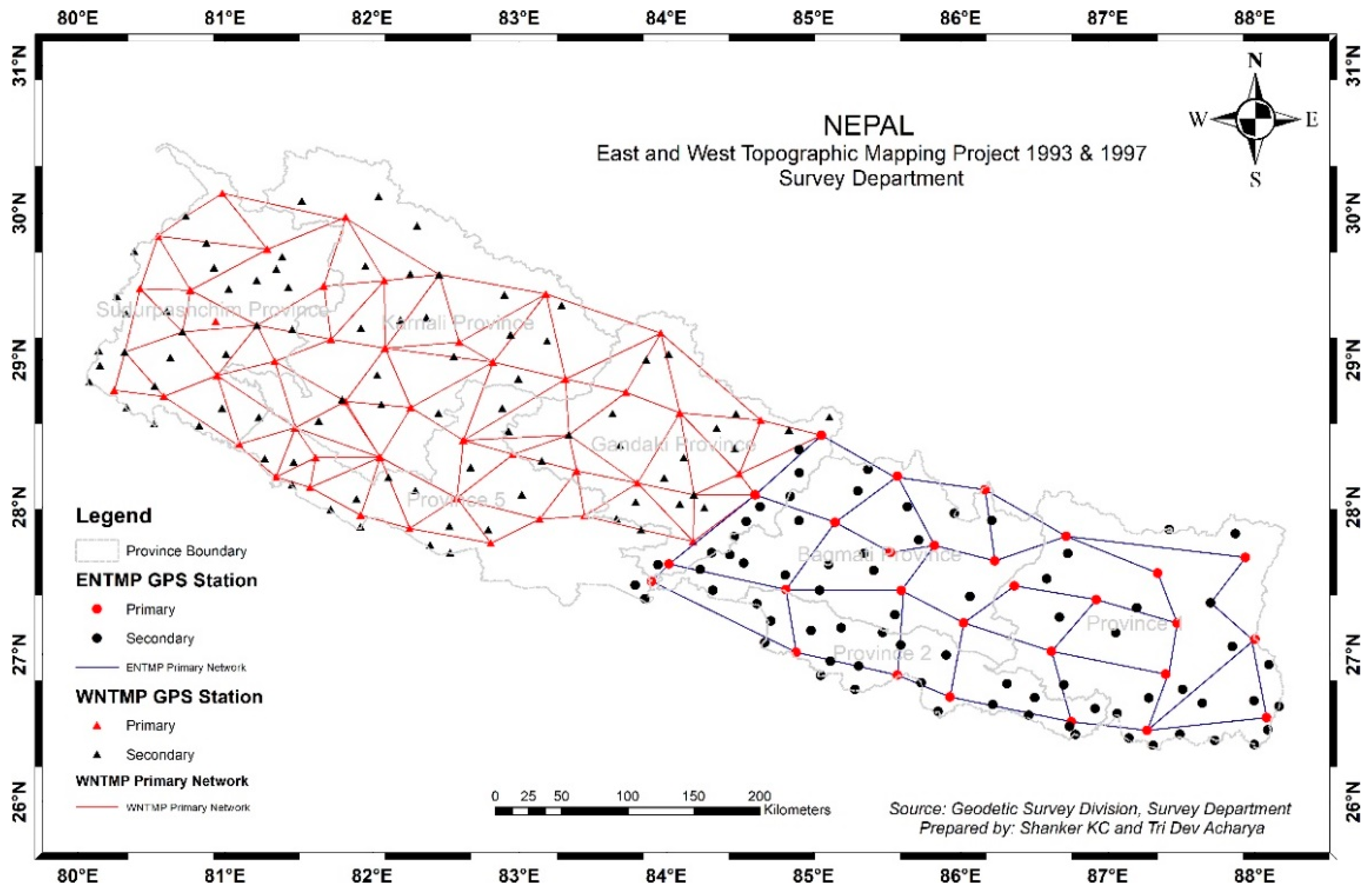
2.1.13. Eastern Nepal Topographic Mapping Project (ENTMP)
2.1.14. Western Nepal Topographic Mapping Project (WNTMP)
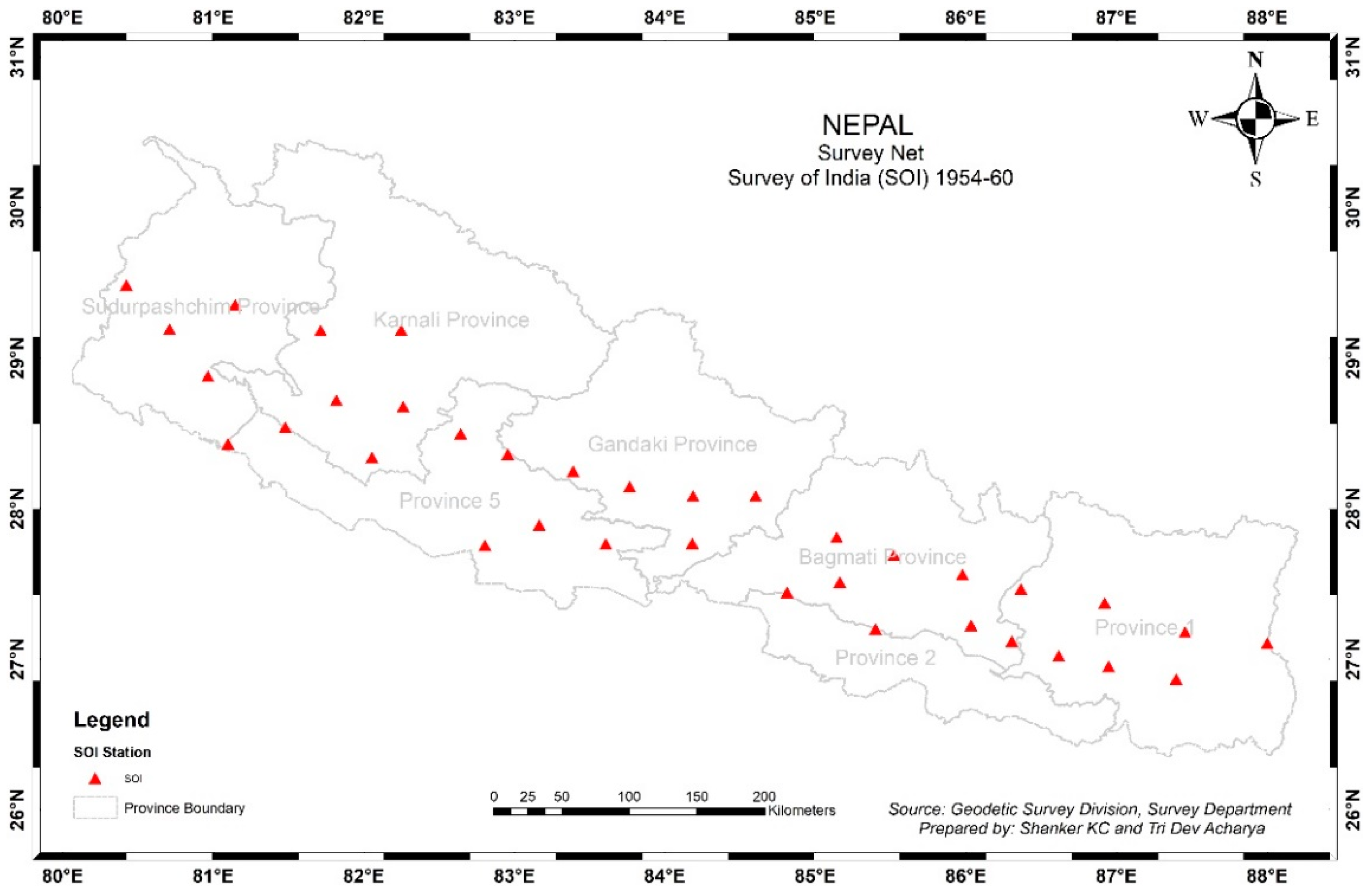
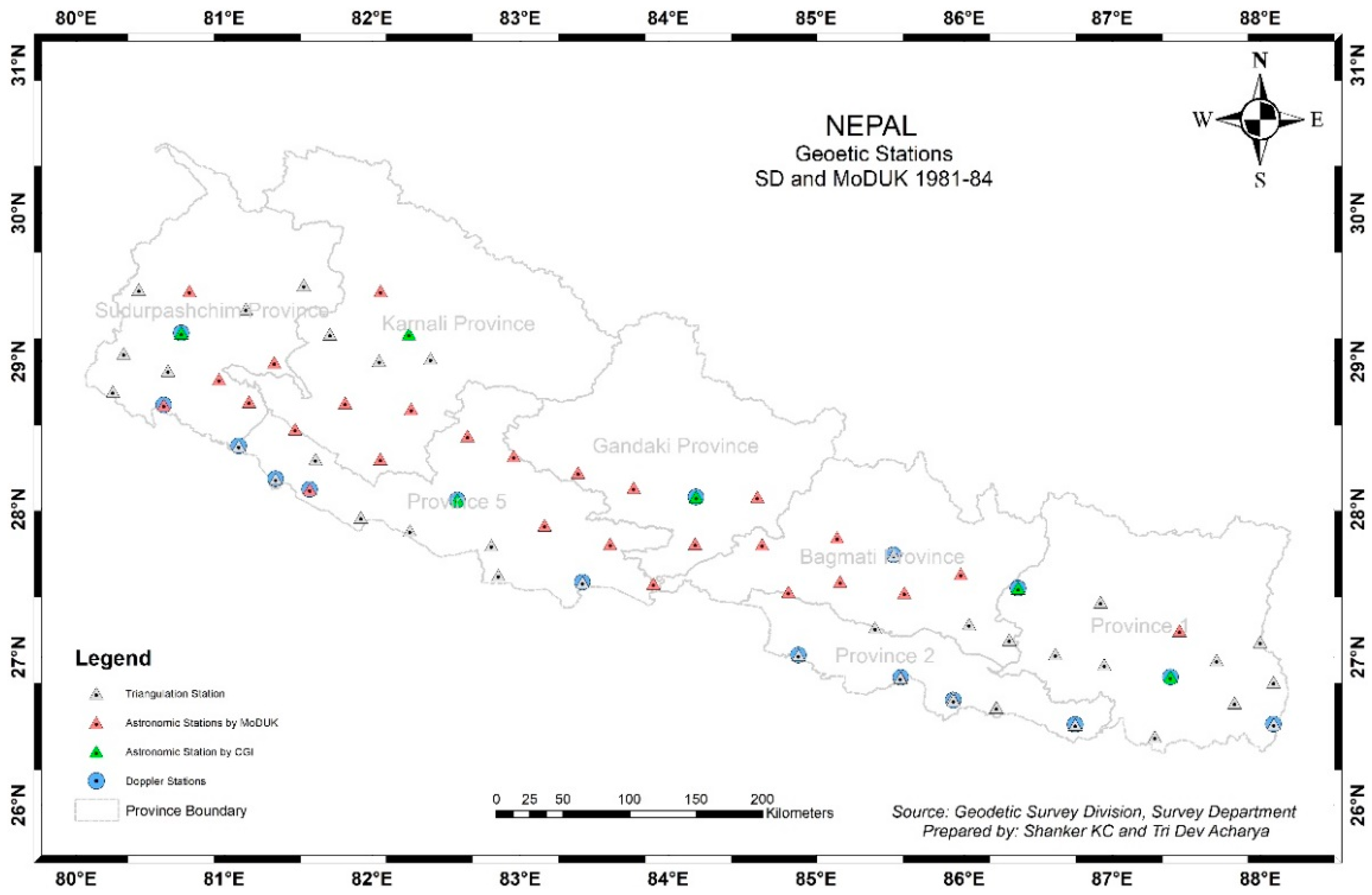
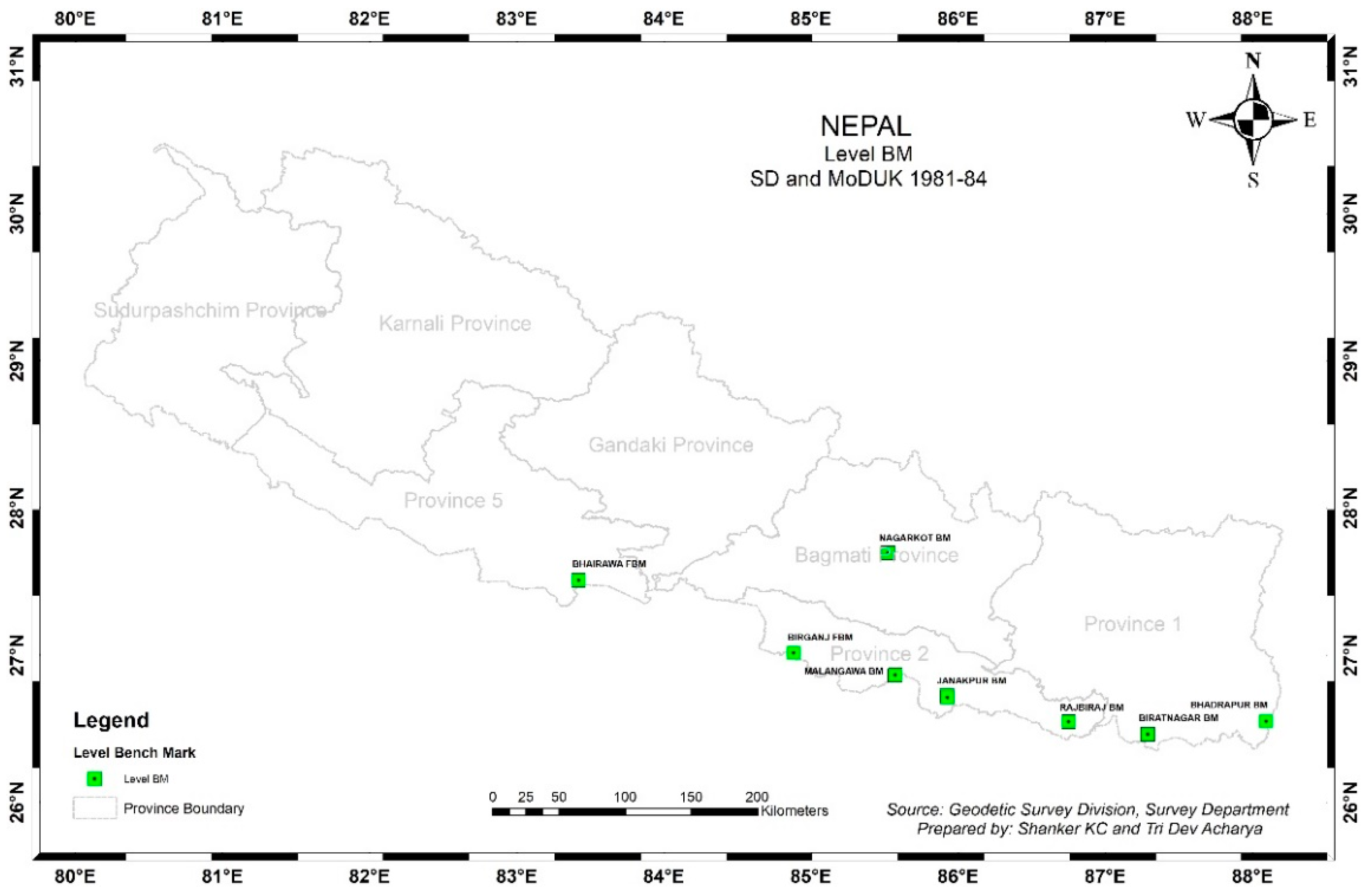
2.1.15. Strengthening of Geodetic Control Network
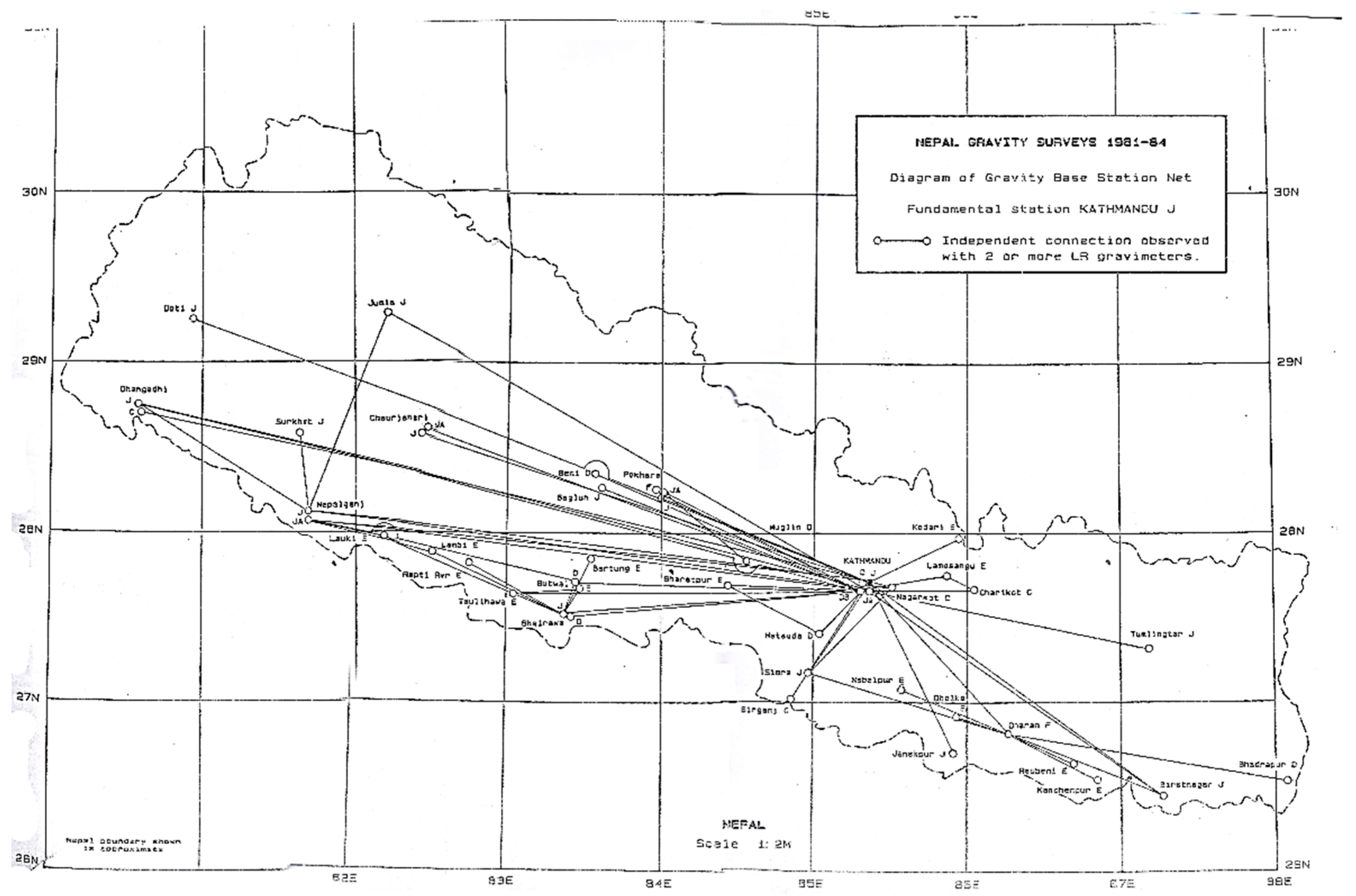
2.1.16. Gravity Survey
- Nepal Gravity Survey 1981–1984
- 2.
- Absolute Gravity Measurement for Geodynamics
- 3.
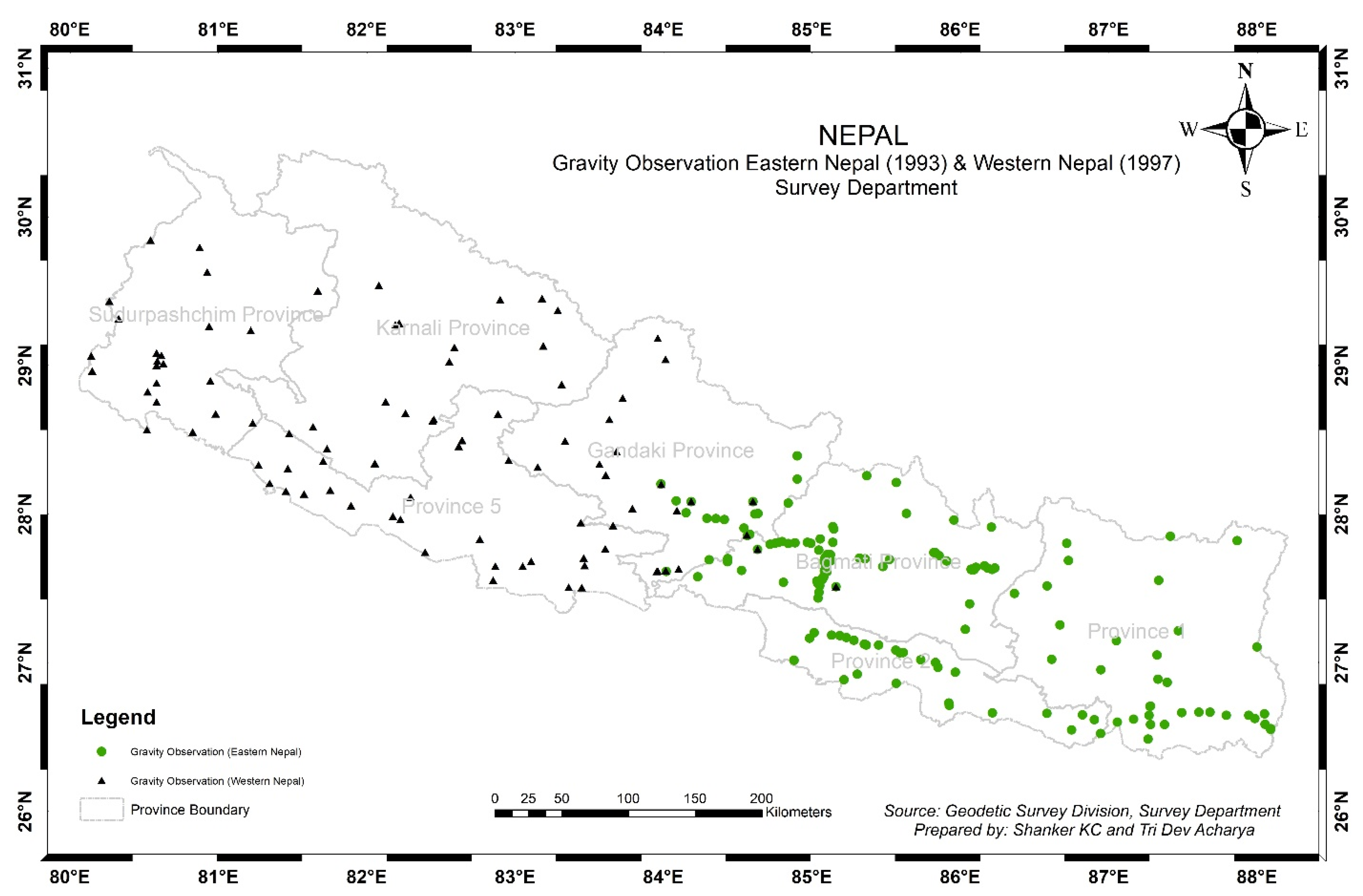
- Gravity Survey in 1993 by ENTMP
- 4.
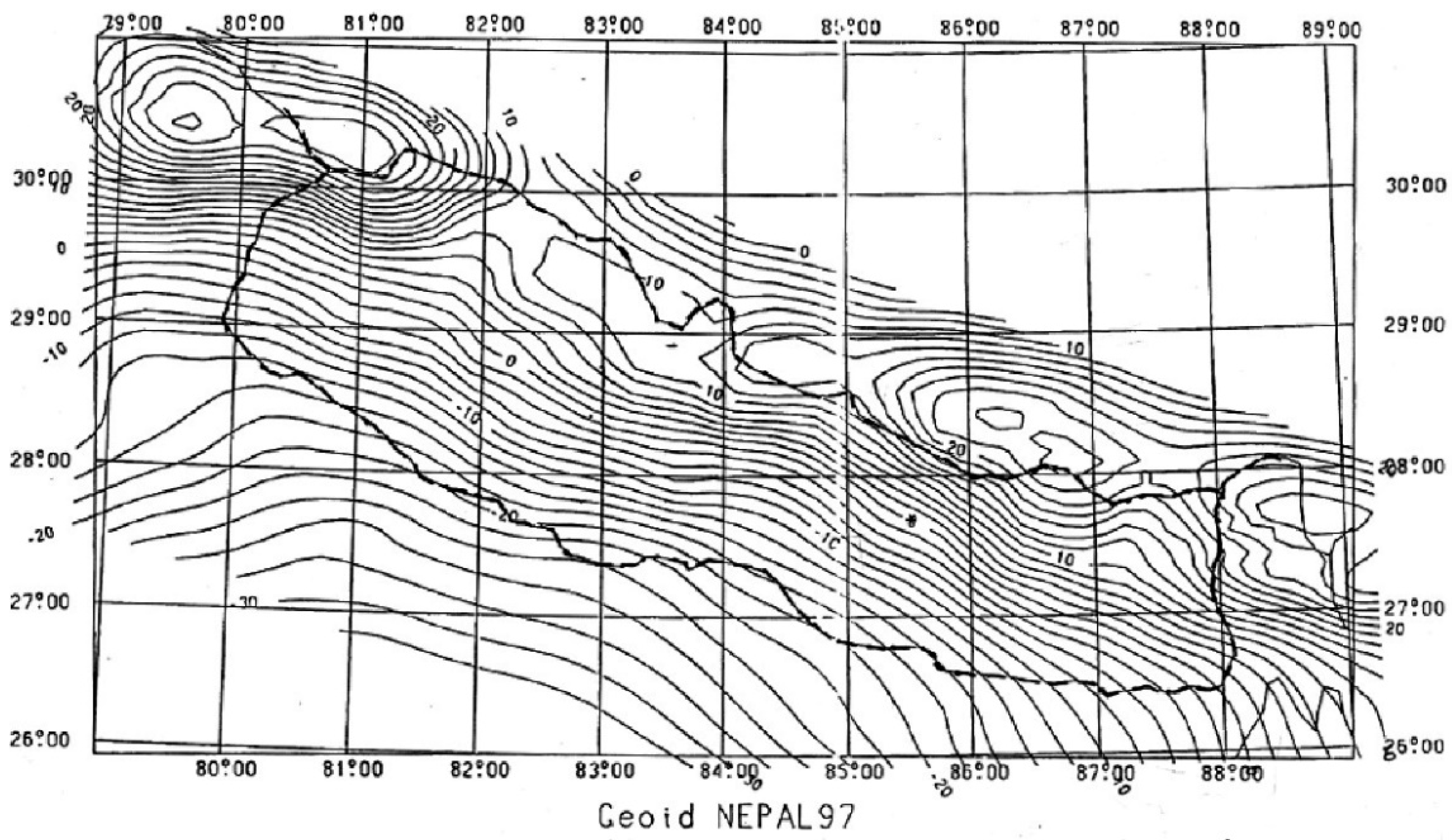
- Gravity Survey in 1997 by WNTMP and NEPAL97 Geoid
- 5.
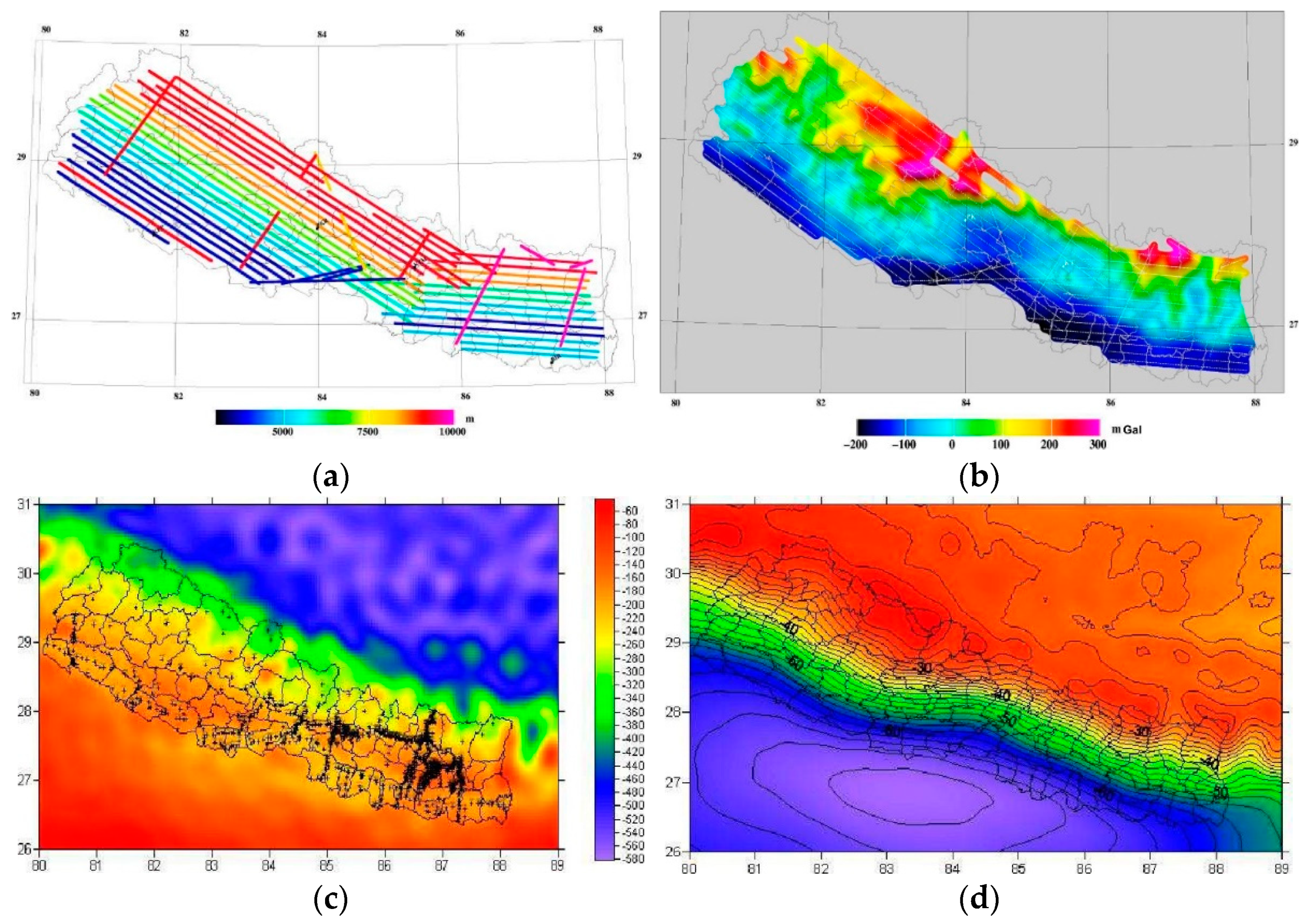
- Airborne Gravity Survey 2010
2.2. Post 2015 Gorkha Earthquake Era
2.2.1. Gorkha Earthquake 2015 and Its Impact on Horizontal and Vertical Datum
2.2.2. CORS Data to Study Earthquake
2.2.3. InSAR Measurements from International Communities
2.2.4. Everest Height Measurement 2020
2.2.5. LiDAR Survey of Western Terai
3. Modernization of Geodesy in Nepal
3.1. Conventional Geodesy
3.2. Modern Geodesy
3.3. Conventional NSRS to Modern NSRS
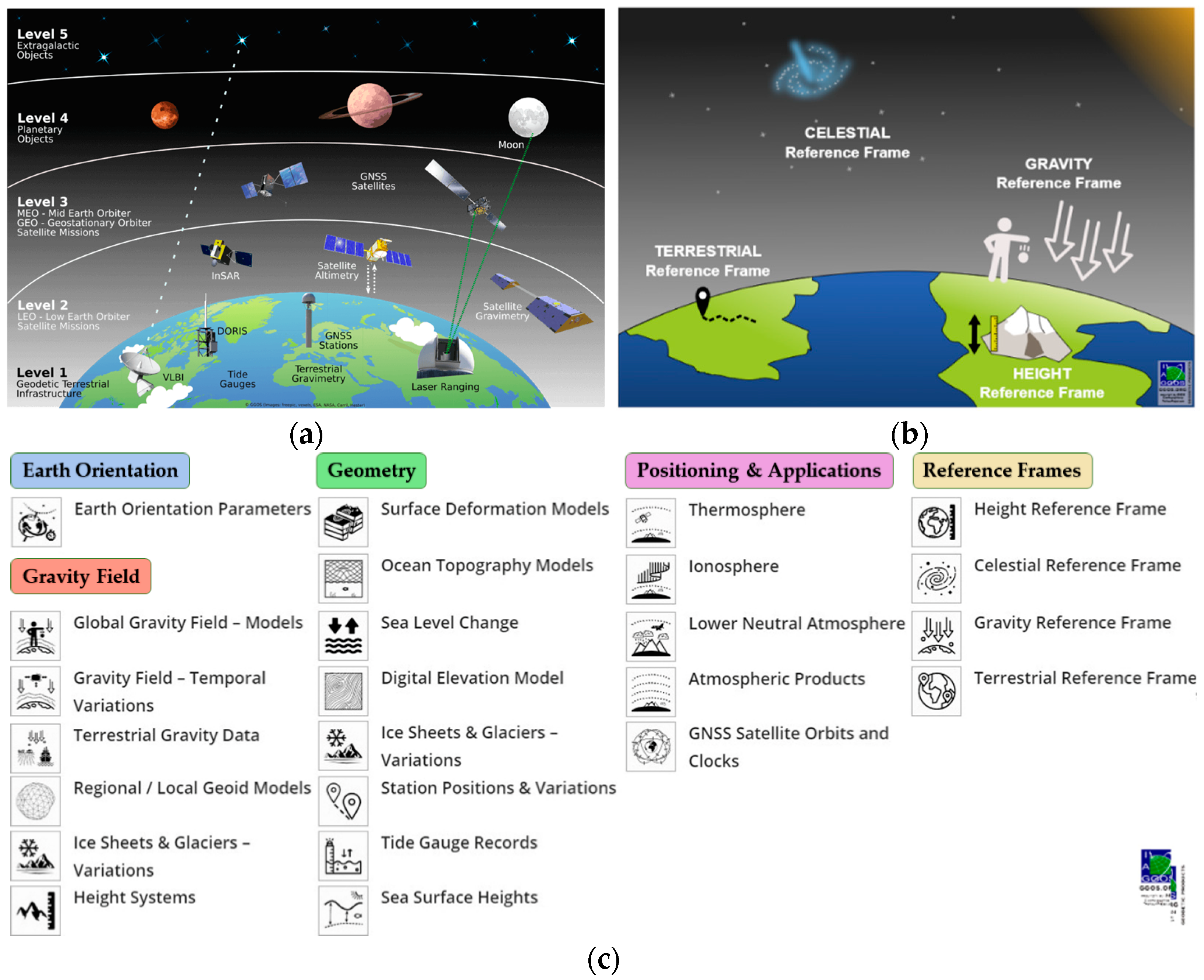
3.3.1. Modern Terrestrial Reference System and Frame
3.3.2. Modern Height Reference System and Frame
3.3.3. Modern Gravity Reference System and Frame
4. Discussion and Future Directions
4.1. Nepalese Geodesy
4.2. Modern Terrestrial Reference System and Its Advantages
4.3. Modern Height Reference System and Its Advantages
4.4. Modern Gravity Reference System and Its Advantages
4.5. Modern NSRS and Its Advantages
4.6. Future Perspectives
Author Contributions
Funding
Institutional Review Board Statement
Informed Consent Statement
Data Availability Statement
Acknowledgments
Conflicts of Interest
Abbreviations
| ALOS | Advanced Land Observing System |
| ARIA | Advanced Rapid Imaging and Analysis |
| ASTER | Advanced Spaceborne Thermal Emission and Reflection Radiometer |
| BGI | International Gravimetric Bureau |
| BM | Benchmarks |
| CGI | Czech Geodetic Institute |
| CIO | Conventional International Origin |
| CIRES | Cooperative Institute for Research in Environment Science |
| CMONOC | Crustal Movement Observation Network of China |
| COMET | Center for Observations and Modeling of Earthquakes, Volcanos, and Tectonics |
| CORS | Continuously Operating Reference Station |
| COST-G | Combination of Service for Time-Variable Gravity Field |
| CU | University of Colorado |
| DEM | Digital Elevation Model |
| DMG | Department of Mines and Geology |
| DoMS | Directorate of Military Survey |
| DORIS | Dopper Orbitography and Radio Positioning Integrated by Satellite |
| DS | Datum Station |
| DTU Space | National Space Institute at Technical University of Denmark |
| ECEF | Earth Centered Earth Fixed |
| EDM | Electronic Distance Measurement |
| EGM08 | Earth Gravity Model 2008 |
| EGM2020 | Earth Gravity Model 2020 |
| ENTMP | Eastern Nepal Topographic Mapping Project |
| ESA | European Space Agency |
| ESISTEM | Extended Simultaneous and Integrated Strain Tensor Estimation From Geodetic and Satellite Deformation Measurement |
| FAGS-1 | Fundamental Absolute Gravity Station |
| FEM | Finite Element Model |
| FGI | Finnish Geodetic Institute |
| GGRS | Global Geodetic Reference System |
| GNSS | Global Navigation Satellite System |
| GPS | Global Positioning System |
| GRACE | Gravity Recovery and Climate Experiment |
| GRS | Gravity Reference System |
| GRS80 | Geodetic Reference System 1980 |
| GSB | Geodetic Survey Branch |
| GSD | Geodetic Survey Division |
| GTS | Great Triangulation Survey |
| GWS | Ground Water Storage |
| HRF | Height Reference System |
| ICGEM | International Service for Global Earth Models |
| IDEMS | International Digital Elevation Model Service |
| IDS | International DORIS Service |
| IDYL | Imagerie et Dynamique de la Lithosphere |
| IGETS | International Geodynamics and Earth Tide Service |
| IGFS | International Gravity Field Service |
| IGS | International GNSS Service |
| IGSN71 | International Gravity Standardization Network 1971 |
| IHRS | International Height Reference System |
| ILRS | International Laser Ranging Service |
| InSAR | Interferometry Synthetic Aperture Radar |
| ISG | International Service for Geoid |
| ITRF | International Terrestiral Reference Frame |
| IVS | International VLBI Service |
| JGD200 | Japanese Geodetic Datum 2000 |
| JICA | Japan International Cooperation Agency |
| JILA | Joint Institute for Laboratory Astrophysics |
| JTBC | Joint Technical Border Committee |
| LCC | Lambert Conformal Conic |
| LDG | Laboratoire de Detection Geophysique |
| LiDAR | Light Detection and Ranging |
| LLR | Lunar Laser Ranging |
| MHT | main Himalayan thrust |
| MoDUK | Ministry of Defense, U.K. |
| MSL | Mean Sea Level |
| NAD83 | North American Datum 1983 |
| NASA | National Aeronautics and Space Administration |
| NAVSTAR | Navigation System using Time and Raning |
| NEIC | National Earthquake Information Center |
| NGA | National Geospatial Intelligence Agency |
| NMA | National Mapping Agency |
| NSRS | National Spatial Reference System |
| NTRF | National Terrestrial Reference Frame |
| PSMSL | Permanent Service for Mean Sea Level |
| RTK | Real-Time Kinematics |
| SAR | Synthetic Aperture Radar |
| SD | Survey Department |
| SLR | Satellite Laser Ranging |
| SOI | Survey of India |
| SRTM | Shuttle Radar Topographic Mission |
| TBM | Topographic Base Map |
| TIA | Tribhuvan International Airport |
| TLS | Terrestrial Laser Scanning |
| TRF | Terrestrial Reference Frame |
| TRS | Terrestrial Reference System |
| TSB | Triangulation Survey Branch |
| UAV | Unmanned Aerial Vechicle |
| UNDP | United Nations Development Program |
| USA | United States of America |
| USGS | United States Geological Survey |
| VLBI | Very-Long-Baseline Interferometry |
| WNTMP | Western Nepal Topographic Mapping Project |
References
- Torge, W. Geodesy; Walter de Grutyer: Berlin, Germany, 2001; ISBN 978-3-11-020718-7. [Google Scholar]
- Vanicek, P. Geodesy, The Concepts; North-Holland Publishing Company: Amsterdam, The Netherlands, 1986; ISBN 0444861491, 9780444861498. [Google Scholar]
- Seeber, G. Satellite Geodesy, 2nd ed.; MATHEMATIK GESAMT; Walter de Gruyter: Berlin, Germany, 2003; ISBN 978-3-11-017549-3. [Google Scholar]
- Plag, H.P.; Pearlman, M. (Eds.) Global Geodetic Observing System; Springer: Berlin/Heidelberg, Germany, 2009; ISBN 978-3-642-02686-7. [Google Scholar]
- Oli, P.P. Astronomy and Gravity Surveying in Nepal. Nepal. J. Geoinform. 2007, 6, 16–24. [Google Scholar]
- Gulatee, B.L. The Height of Mt. Everest: A New Determination (1952–1954); Survey of India Dehradun: Dehradun, India, 1954. [Google Scholar]
- Shrestha, K.G. An Approach to Determine Coordinate Transformation Parameter for Nepal GPS Network. Nepal. J. Geoinform. 2011, 10, 9–13. [Google Scholar] [CrossRef]
- Geodesy Division Directorate of Military Survey Ministry of Deference UK. Report and Results of a Geodetic Survey of Nepal 1981–1984; Geodesy Division Directorate of Military Survey Ministry of Deference UK: Kathmandu, Nepal, 1985.
- Adhikary, K.R. Global Positioning System on Cadastral Survey of Nepal. Nepal. J. Geoinform. 2002, 2, 58–62. [Google Scholar]
- Adhikary, K.R. Global Positioning System and Strengthening of Geodetic Network of Nepal. Nepal. J. Geoinform. 2004, 3, 955–958. [Google Scholar]
- Manandhar, N.; Bhattarai, M.P. An Overview on Time Series of Geodetic and GPS Network of Nepal. Nepal. J. Geoinform. 2002, 1, 53–57. [Google Scholar]
- Jackson, M.E.; Bilham, R. 1991–1992 GPS measurements across the Nepal Himalaya. Geophys. Res. Lett. 1994, 21, 1169–1172. [Google Scholar] [CrossRef]
- Jouanne, F.; Mugnier, J.L.; Gamond, J.F.; Le Fort, P.; Pandey, M.R.; Bollinger, L.; Flouzat, M.; Avouac, J.P. Current shortening across the Himalayas of Nepal. Geophys. J. Int. 2004, 157, 1–14. [Google Scholar] [CrossRef]
- Manandhar, N.; KC, S. Geoid Determination and Gravity Works in Nepal. J. Geoinform. Nepal 2018, 14, 7–15. [Google Scholar] [CrossRef]
- Sivasami, K.S. The Great Trigonometrical Survey of India—Geospatial World. Available online: https://www.geospatialworld.net/article/the-great-trigonometrical-survey-of-india/ (accessed on 23 June 2021).
- Shrestha, S. The First Map of Nepal. Kathmandu Post. 2017. Available online: https://kathmandupost.com/miscellaneous/2017/12/30/the-first-map-of-nepal (accessed on 23 June 2021).
- Chhatkuli, R.R. From Cadastral Survey Plan to Geographic Information Infrastructure Fifty Years of Evolution of Geo-spatial Data Policy in Nepal. Nepal. J. Geoinform. 2007, 6, 1–9. [Google Scholar]
- Paskin, M. Nepal 1982–1985|Flickr. Available online: https://www.flickr.com/photos/thulobaba/albums/72157608084070023 (accessed on 29 July 2021).
- Gautam, K. A History of Everest Mapping. Available online: https://gogeomatics.ca/a-history-of-everest-mapping/ (accessed on 6 August 2021).
- Molodtsov, Y. Everest Altitude Measurement History|Mountain Planet. Available online: https://mountainplanet.com/everest-altitude-measurement-history (accessed on 10 March 2022).
- Poretti, G. Is Mount Everest Higher Now Than 155 Years Ago? CER Telegeomatica—Università di Trieste: Trieste, Italy, 2015. [Google Scholar]
- Chakraborty, R. Border Disputes between China and Nepal|ORF. Available online: https://www.orfonline.org/expert-speak/border-disputes-between-china-and-nepal/ (accessed on 31 July 2021).
- Baral, T.N. Border Disputes and Its Impact on Bilateral Relation: A Case of Nepal-India International Border Management. J. APF Command Staff Coll. 2018, 1, 28–36. [Google Scholar] [CrossRef][Green Version]
- Government of Nepal. Survey and Measurement Act; Department of Printing: Kathmandu, Nepal, 1961. Available online: https://dos.gov.np/down-load/download/land-survey-and-measurement-act-2019-1963/downloads (accessed on 23 June 2021).
- The Launch of Sputnik. 1957. Available online: https://2001-2009.state.gov/r/pa/ho/time/lw/103729.htm (accessed on 7 March 2022).
- Ader, T.; Avouac, J.-P.; Liu-Zeng, J.; Lyon-Caen, H.; Bollinger, L.; Galetzka, J.; Genrich, J.; Thomas, M.; Chanard, K.; Sapkota, S.N.; et al. Convergence rate across the Nepal Himalaya and interseismic coupling on the Main Himalayan Thrust: Implications for seismic hazard. J. Geophys. Res. Solid Earth 2012, 117. [Google Scholar] [CrossRef]
- Anzidei, M. GPS surveys in eastern Nepal. Terra Nov. 1994, 6, 82–89. [Google Scholar] [CrossRef]
- Freymueller, J.; Bilham, R.; Bürgmann, R.; Larson, K.M.; Paul, J.; Jade, S.; Gaur, V. Global Positioning System measurements of Indian Plate Motion and convergence across the lesser Himalaya. Geophys. Res. Lett. 1996, 23, 3107–3110. [Google Scholar] [CrossRef]
- Bilham, R.; Larson, K.; Freymueller, J. GPS measurements of present-day convergence across the Nepal Himalaya. Nature 1997, 386, 61–64. [Google Scholar] [CrossRef]
- Blume, F. Determination of Source Parameters of the Great 1934 Nepal Earthquake Using Historic and Modern Geodesy. Ph.D. Thesis, University of Colorado at Boulder, Boulder, CO, USA, 1999. [Google Scholar]
- Flouzat, M.; Bettinelli, P.; Willis, P.; Avouac, J.-P.; Héritier, T.; Gautam, U. Investigating tropospheric effects and seasonal position variations in GPS and DORIS time-series from the Nepal Himalaya. Geophys. J. Int. 2009, 178, 1246–1259. [Google Scholar] [CrossRef]
- Fu, Y. Loading Deformation on Various Timescales Using GPS and GRACE Measurements. Ph.D. Thesis, University of Alaska Fairbanks, Fairbanks, AK, USA, 2012. Available online: https://scholarworks.alaska.edu/handle/11122/916 (accessed on 10 March 2022).
- Fu, Y.; Freymueller, J.T. Seasonal and long-term vertical deformation in the Nepal Himalaya constrained by GPS and GRACE measurements. J. Geophys. Res. Solid Earth 2012, 117, 3407. [Google Scholar] [CrossRef]
- Fu, Y.; Argus, D.F.; Freymueller, J.T.; Heflin, M.B. Horizontal motion in elastic response to seasonal loading of rain water in the Amazon Basin and monsoon water in Southeast Asia observed by GPS and inferred from GRACE. Geophys. Res. Lett. 2013, 40, 6048–6053. [Google Scholar] [CrossRef]
- Chanard, K.; Avouac, J.P.; Ramillien, G.; Genrich, J. Modeling deformation induced by seasonal variations of continental water in the Himalaya region: Sensitivity to Earth elastic structure. J. Geophys. Res. Solid Earth 2014, 119, 5097–5113. [Google Scholar] [CrossRef]
- Liu, B.; Dai, W.; Liu, N. Extracting seasonal deformations of the Nepal Himalaya region from vertical GPS position time series using Independent Component Analysis. Adv. Space Res. 2017, 60, 2910–2917. [Google Scholar] [CrossRef]
- Zhang, T.; Shen, W.; Pan, Y.; Luan, W. Study of seasonal and long-term vertical deformation in Nepal based on GPS and GRACE observations. Adv. Space Res. 2018, 61, 1005–1016. [Google Scholar] [CrossRef]
- Saji, A.P.; Sunil, P.S.; Sreejith, K.M.; Gautam, P.K.; Kumar, K.V.; Ponraj, M.; Amirtharaj, S.; Shaju, R.M.; Begum, S.K.; Reddy, C.D.; et al. Surface Deformation and Influence of Hydrological Mass over Himalaya and North India Revealed from a Decade of Continuous GPS and GRACE Observations. J. Geophys. Res. Earth Surf. 2020, 125, 1–17. [Google Scholar] [CrossRef]
- Ray, J.D.; Vijayan, M.S.M.; Godah, W. Seasonal horizontal deformations obtained using GPS and GRACE data: Case study of North-East India and Nepal Himalaya. Acta Geod. Geophys. 2021, 56, 61–76. [Google Scholar] [CrossRef]
- Tiwari, V.M.; Wahr, J.; Swenson, S. Dwindling groundwater resources in northern India, from satellite gravity observations. Geophys. Res. Lett. 2009, 36, L18401. [Google Scholar] [CrossRef]
- Shamsudduha, M.; Panda, D.K. Spatio-temporal changes in terrestrial water storage in the Himalayan river basins and risks to water security in the region: A review. Int. J. Disaster Risk Reduct. 2019, 35, 101068. [Google Scholar] [CrossRef]
- Shrestha, B.N.; Bilham, R.; Jackson, M.E.; Molnar, P.; Wenying, W.; Guoguang, Z.; Stephens, B.; Normandeau, J. Nepal-Tibet GPS Survey; Survey Department: Kathmandu, Nepal, 1991. [Google Scholar]
- HMG Survey Department of Nepal. FM-International FINNMAP Eastern Nepal Topographic Mapping Project, Report on GPS—Surveys; HMG Survey Department: Kathmandu, Nepal, 1993.
- HMG Survey Department of Nepal. FM-International FINNMAP Western Nepal Topographic Mapping Project Phase I Final Report of Ground Control Surveys Volume I: Report; Survey Department: Kathmandu, Nepal, 1997.
- Directorate of Military Surveys Ministry of Defense UK. Report and Results of Gravity Surveys in Nepal 1981–1984; Directorate of Military Surveys Ministry of Defense UK: Kathmandu, Nepal, 1985.
- Winester, D.; Fried, J.; Bernard, B.; Shrestha, L.; Shrestha, N.B.; Adiga, G.; Bilham, R.; Faller, J. Absolute Gravity, Nagarkot Observatory, Observations, Corrections, and Results Gravity Ties to Kathmandu and Simara Airport; HMG Survey Department: Kathmandu, Nepal, 1991. [Google Scholar]
- National Geodetic Survey, University of Colorado Nagarkot Geodetic Observatory, Nepal, Observations, Corrections, and Results; HMG Survey Department: Kathmandu, Nepal, 1991.
- HMG Survey Department of Nepal. FM-International FINNMAP Western Nepal Topographic Mapping Project Phase I Final Report of Ground Control Surveys Volume III: Definition of Gravimetric Geoid; HMG Survey Department: Kathmandu, Nepal, 1997.
- Forsberg, R.; Olesen, A.V.; Einarsson, I.; Manandhar, N.; Shreshta, K. Geoid of Nepal from Airborne Gravity Survey. In Proceedings of the International Association of Geodesy Symposia, Luxembourg, 13–17 October 2014; Volume 139, pp. 521–527. [Google Scholar]
- Manandhar, N. Himalayan Airborne Gravity and Geoid. In Proceedings of the United Nations/Nepal Workshop on the Applications of Global Navigation Satellite Systems, Kathmandu, Nepal, 12–16 December 2016; UNOOSA Publications: Kathmandu, Nepal, 2016. [Google Scholar]
- Chen, S.; Liu, M.; Xing, L.; Xu, W.; Wang, W.; Zhu, Y.; Li, H. Gravity increase before the 2015 Mw 7.8 Nepal earthquake. Geophys. Res. Lett. 2016, 43, 111–117. [Google Scholar] [CrossRef]
- Phuyal, K.P. Analysis of Gravity for the Crustal Structure of Nepal Himalaya. Master's Thesis, Missouri State University, Springfield, MO, USA, 2021. [Google Scholar]
- Elliott, J.R.; Jolivet, R.; González, P.J.; Avouac, J.-P.; Hollingsworth, J.; Searle, M.P.; Stevens, V.L. Himalayan megathrust geometry and relation to topography revealed by the Gorkha earthquake. Nat. Geosci. 2016, 9, 174–180. [Google Scholar] [CrossRef]
- Shrestha, K.G. Bye Bye EQ2015,11:56AM. Nepal. J. Geoinform. 2015, 14, 1–3. [Google Scholar] [CrossRef]
- Gualandi, A.; Avouac, J.-P.; Galetzka, J.; Genrich, J.F.; Blewitt, G.; Adhikari, L.B.; Koirala, B.P.; Gupta, R.; Upreti, B.N.; Pratt-Sitaula, B.; et al. Pre- and post-seismic deformation related to the 2015, Mw 7.8 Gorkha earthquake, Nepal. Tectonophysics 2017, 714–715, 90–106. [Google Scholar] [CrossRef]
- Huang, Y.; Yang, S.; Qiao, X.; Lin, M.; Zhao, B.; Tan, K. Measuring ground deformations caused by 2015 Mw 7.8 Nepal earthquake using high-rate GPS data. Geod. Geodyn. 2017, 8, 285–291. [Google Scholar] [CrossRef]
- Feng, W.; Lindsey, E.; Barbot, S.; Samsonov, S.; Dai, K.; Li, P.; Li, Z.; Almeida, R.; Chen, J.; Xu, X. Source characteristics of the 2015 Mw 7.8 Gorkha (Nepal) earthquake and its Mw 7.2 aftershock from space geodesy. Tectonophysics 2017, 712–713, 747–758. [Google Scholar] [CrossRef]
- Feng, G.; Li, Z.; Shan, X.; Zhang, L.; Zhang, G.; Zhu, J. Geodetic model of the 2015 April 25 Mw 7.8 Gorkha Nepal Earthquake and Mw 7.3 aftershock estimated from InSAR and GPS data. Geophys. J. Int. 2015, 203, 896–900. [Google Scholar] [CrossRef]
- Grandin, R.; Vallée, M.; Satriano, C.; Lacassin, R.; Klinger, Y.; Simoes, M.; Bollinger, L. Rupture process of the Mw = 7.9 2015 Gorkha earthquake (Nepal): Insights into Himalayan megathrust segmentation. Geophys. Res. Lett. 2015, 42, 8373–8382. [Google Scholar] [CrossRef]
- Luo, H.; Chen, T. Three-Dimensional Surface Displacement Field Associated with the 25 April 2015 Gorkha, Nepal, Earthquake: Solution from Integrated InSAR and GPS Measurements with an Extended SISTEM Approach. Remote Sens. 2016, 8, 559. [Google Scholar] [CrossRef]
- Wang, K.; Fialko, Y. Observations and Modeling of Coseismic and Postseismic Deformation Due to the 2015 Mw 7.8 Gorkha (Nepal) Earthquake. J. Geophys. Res. Solid Earth 2018, 123, 761–779. [Google Scholar] [CrossRef]
- Sreejith, K.M.; Sunil, P.S.; Agrawal, R.; Saji, A.P.; Rajawat, A.S.; Ramesh, D.S. Audit of stored strain energy and extent of future earthquake rupture in central Himalaya. Sci. Rep. 2018, 8, 16697. [Google Scholar] [CrossRef] [PubMed]
- Hong, S.; Liu, M. Postseismic Deformation and Afterslip Evolution of the 2015 Gorkha Earthquake Constrained by InSAR and GPS Observations. J. Geophys. Res. Solid Earth 2021, 126, 1–17. [Google Scholar] [CrossRef]
- Barnhart, W.D.; Hayes, G.P.; Wald, D.J. Global Earthquake Response with Imaging Geodesy: Recent Examples from the USGS NEIC. Remote Sens. 2019, 11, 1357. [Google Scholar] [CrossRef]
- Survey Department Ht. of Mt. Everest Measurement. Available online: http://web.archive.org/web/20210306043056/http://www.dos.gov.np:80/everest/progress1.html (accessed on 10 March 2022).
- Global Geodetic Observing System Products—GGOS Website. Available online: https://ggos.org/products/ (accessed on 28 June 2021).
- Yang, Y.X. Chinese Geodetic Coordinate System 2000. Chin. Sci. Bull. 2009, 54, 2714–2721. [Google Scholar] [CrossRef]
- Hiyama, Y.; Yamagiwa, A.; Kawahara, T.; Iwata, M.; Fukuzaki, Y.; Shouji, Y.; Sato, Y.; Yutsudo, T.; Sasaki, T.; Yamaguchi, K.; et al. Revision of the Results of Control Points after the 2011 off the Pacific coast of Tohoku Earthquake. In Proceedings of the FIG Working Week, Marrakech, Morocco, 18–22 May 2011; pp. 6–10. [Google Scholar]
- Moritz, H. Geodetic reference system 1980. Bull. Géodésique 1980, 54, 395–405. [Google Scholar] [CrossRef]
- Hwang, C.; Hsiao, Y.-S. Orthometric corrections from leveling, gravity, density and elevation data: A case study in Taiwan. J. Geod. 2003, 77, 279–291. [Google Scholar] [CrossRef]


| Organization, Country | Year | Elevation of the Peak (Meter) | Method |
|---|---|---|---|
| Survey of India, India | 1852 | 8840 | Triangulation |
| Survey of India, India | 1904 | 8882 | Triangulation |
| Survey of India, India | 1930 | 8854 ± 5 | Triangulation |
| Survey of India, India | 1954 | 8848 | Triangulation |
| Ardito Desio, Italy | 1987 | 8872 | Triangulation |
| EV-K2-CNR, Italy and National Bureauof Surveying and Mapping, China | 1992 | 8848.65 ± 0.35 | GPS and Geoid |
| National Bureau of Surveying and Mapping, China | 1999 | 8849.71 | GPS and Geoid |
| Boston Museum of Science, USA | 1999 | 8850 ± 2 | GPS and Geoid |
| EV-K2-CNR, Italy | 2004 | 8852.12 ± 0.12 | GPS and Geoid |
| State Bureau of Surveying and Mapping, China | 2005 | 8847.93 ± 0.14 | GNSS and Geoid |
| Survey Department, Nepal | 2020 | 8848.86 | GNSS and Geoid |
| Order of Control Survey | Triangular Misclosure | No of Sets (Angular Measurement) | Reference Object to Reference Object Closing | Distance between Stations |
|---|---|---|---|---|
| Second | 10 cc | 9 | 10 cc | 9–15 km |
| Third | 10 cc | 6 | 15 cc | 3–7 km |
| Fourth | 75 cc | 3 | 30 cc | 0.2–3 km |
Publisher’s Note: MDPI stays neutral with regard to jurisdictional claims in published maps and institutional affiliations. |
© 2022 by the authors. Licensee MDPI, Basel, Switzerland. This article is an open access article distributed under the terms and conditions of the Creative Commons Attribution (CC BY) license (https://creativecommons.org/licenses/by/4.0/).
Share and Cite
KC, S.; Acharya, T.D. Advancements of Geodetic Activities in Nepal: A Review on Pre- and Post-2015 Gorkha Earthquake Eras with Future Directions. Remote Sens. 2022, 14, 1586. https://doi.org/10.3390/rs14071586
KC S, Acharya TD. Advancements of Geodetic Activities in Nepal: A Review on Pre- and Post-2015 Gorkha Earthquake Eras with Future Directions. Remote Sensing. 2022; 14(7):1586. https://doi.org/10.3390/rs14071586
Chicago/Turabian StyleKC, Shanker, and Tri Dev Acharya. 2022. "Advancements of Geodetic Activities in Nepal: A Review on Pre- and Post-2015 Gorkha Earthquake Eras with Future Directions" Remote Sensing 14, no. 7: 1586. https://doi.org/10.3390/rs14071586
APA StyleKC, S., & Acharya, T. D. (2022). Advancements of Geodetic Activities in Nepal: A Review on Pre- and Post-2015 Gorkha Earthquake Eras with Future Directions. Remote Sensing, 14(7), 1586. https://doi.org/10.3390/rs14071586