Article

Intelligent Control of Building Operation and Maintenance Processes Based on Global Navigation Satellite System and Digital Twins

1
Faculty of Architecture, Civil and Transportation Engineering, Beijing University of Technology, Beijing 100124, China
2
The Key Laboratory of Urban Security and Disaster Engineering of the Ministry of Education, Beijing University of Technology, Beijing 100124, China
*
Author to whom correspondence should be addressed.
Remote Sens. 2022, 14(6), 1387; https://doi.org/10.3390/rs14061387
Submission received: 18 February 2022 / Revised: 11 March 2022 / Accepted: 12 March 2022 / Published: 13 March 2022

Abstract

:
Building operation and maintenance (O&M) processes are tedious. Controlling such tedious processes requires extensive visualization and trustworthy decision-making strategies. Unfortunately, challenges still exist as existing technologies and practices can hardly achieve effective control of building O&M processes. This study has established a method for achieving intelligent control of building O&M processes by integrating Global Navigation Satellite System (GNSS) with Digital Twins (DTs) techniques. Specifically, GNSS could be used to capture real-time building information during building O&M processes. Such captured real-time information realizes the intelligent closed-loop control of building O&M driven by DTs. In this study, the authors have (1) captured the dynamic information required for achieving intelligent control of building O&M processes, (2) established a DT model of building O&M processes, (3) established a data management mechanism of intelligent building O&M processes, and (4) formalized an intelligent building O&M decision control platform. Finally, the authors have validated the proposed method using the 2022 Beijing Winter Olympics venue as a case study. The three-dimensional coordinates of various building information are captured based on GNSS automatic monitoring system. This realizes the precise positioning of O&M elements and feedbacks to the twin model of the venue. Through the intelligent analysis and prediction of O&M information, the characteristics of various O&M accidents are obtained. Finally, under the navigation function of GNSS, the processing measures are accurately formulated. Results indicate that the proposed GNSS–DTs-based method could help to achieve intelligent control of large building O&M processes.

1. Introduction

1.1. Background

Emerging information technologies have promoted the transformation of the construction industry [1]. In view of how to deepen the integration and application of information technology in the construction industry, each country proposes corresponding development strategies based on its own national conditions. This promotes the rapid development of information physics integration, digital twins (DTs), and other related technologies [2]. More and more information technologies are applied to the human living space to improve its comfort, energy-saving, and safety. Smart city, intelligent building, smart home, and other concepts are more and more studied by people. Among them, building environment, building energy, building safety, and other issues are the main research issues.
It is the basic connotation of operation and maintenance (O&M) to use various technical means to help the protected object avoid danger and injury and keep it in a normal state without dangerous accidents. Therefore, building O&M is an important work to ensure construction environment, energy, and safety. The traditional O&M mainly realizes the protection of building safety through the inspection of O&M managers. At present, the development of digital architecture in business applications still has difficulty in collecting high-precision information, serious information islands, scattered infrastructure, and unbalanced O&M systems [3]. With the development of information technology, intelligent O&M management facilities are increasingly appearing in urban and building management. The O&M process should gradually realize the data collaborative interaction of multiple factors such as personnel, construction, and environment, so as to improve the intelligent level of management and maintenance.
In the emerging modern technologies, DTs provide new methods and ideas for the refinement and intelligent development of large and complex building O&M and create new tools. DTs have a great role in promoting the intelligence of engineering construction and management [4]. In recent years, the intelligent development of DTs and O&M [5] has been paid more and more attention by experts and scholars in the industry and has achieved fruitful results in the industry. DTs simulate and depict the state and behavior of physical entities with a high-fidelity dynamic virtual model. As a link between the real physical world and the virtual digital space, it is the key enabling technology to realize the intelligent O&M of buildings [6]. In the process of O&M, DTs can realize real-time mapping of building state, intelligently analyze the state of each factor, and predict the future development trend of each factor. In the process of improving the intelligent level of building O&M, the corresponding information of DTs requires dynamic action. Therefore, it is necessary to capture the information of various elements in real time. Especially when building O&M accidents occur, accurate positioning of information should be carried out to assist the formulation of maintenance measures and the efficient O&M of buildings. DTs can be used as the technical basis for information integration in the process of building construction, O&M [7]. Global Navigation Satellite System (GNSS) has been an important choice for the development of vehicle positioning navigation and intelligent traffic control because of its high precision and all-weather, all-time, efficiency and convenient characteristics. It plays an important role in many traffic system applications [8]. On the one hand, GNSS captures three-dimensional coordinates of various elements in real time to assist the establishment of twin models. On the other hand, when the building information is abnormal in the twin model, it can be maintained by GNSS high-precision positioning. Therefore, the integration of DTs and GNSS can realize real-time mapping, intelligent analysis, and precise maintenance of building information.
In the O&M process of 2022 Beijing Winter Olympics venues—snowmobile sled venues, the layout of the building is complex, and the number of personnel is large and dense. Once there are dangerous events involving things such as equipment, structural component damage, and excessive personnel density, it will not only cause a large number of life and property losses, but also may cause serious adverse social effects. In order to improve the technology and safety level of the O&M of the venues, it is necessary to use new information technology to provide technical services for the intelligent O&M of the Winter Olympics venues. The overall snowmobile sled venue is an outdoor environment, and the accuracy of GNSS can be effectively played. The construction of the venue is complex, and the real-time mapping of various elements information can be realized by DTs modeling. Therefore, this study carried out the preliminary practice and application of GNSS–DTs for the O&M of 2022 Beijing Winter Olympics sleigh venues.

1.2. Literature Review

1.2.1. O&M of Buildings

At present, with the development of information technology, intelligent O&M management is increasingly appearing in urban and construction management. Using BIM technology to realize an intelligent O&M system is an important research direction. Yang et al. [9] proposed a method for constructing (1) a BIM-based dynamic O&M management and control system, and (2) an augmented reality-based human–computer interaction system. Duan et al. [10] examined a three-dimensional nonlinear cost control system for improving the efficiency of bridge management. Song et al. [11] established a BIM-based collaborative management platform for tunnel engineering projects. Chen et al. [12] proposed a management process design scheme that integrates BIM with digital programming to achieve effective progress monitoring and cost control during building maintenance. Obtaining access to BIM-based facility information from the construction stage for supporting building O&M processes is challenging. Kim et al. [13] proposed an information extraction method by linking various building elements and facility management information to the facility management system database. Belussi et al. [14] investigated the performance of various energy consumption applications according to the concept of zero energy.

1.2.2. DTs

Through the research and application analysis of the building O&M stage, it is found that there are few studies on the integration and integration mechanism of various elements in the O&M stage. The integration of DTs with other information technologies provides a new idea for the transformation and upgrading of the construction industry [15], which can promote the intelligence of construction O&M. DTs integrate the functions of AI, machine learning, and data analytics to create a real-time digital simulation model. Such a model could represent and predict the current and future conditions of physical counterparts by continuously learning and updating from multiple sources [16]. Liu et al. [17] established a DT-based indoor safety management system to improve the indoor safety management of buildings. Marai et al. [18] developed a real-time data collection and analysis method by using the Internet of Things (IoT), thus creating a DT of physical road assets. Kaewunruen et al. [19] established a 6D DT model for effective management of railway systems through their lifecycle. The established model could help to integrate various information for component installation, operation management, and demolition. Lu et al. [16] proposed a DT-based system for supporting the decision-making during O&M of construction projects. Peng et al. [20] developed a DT-based remote diagnosis system and an AI-based diagnosis module in various building O&M processes.

1.2.3. GNSS

GNSS surveying and mapping technology uses satellites for measurement and observation activities. Without the influence of weather changes, it can continuously and dynamically monitor the monitoring points. While ensuring the measurement accuracy, there is no need to establish a visibility between the observation stations. The measurement is simple and convenient and has the inherent advantages of application in engineering surveying and mapping. GNSS measurement accuracy is very high, usually within millimeters. In engineering surveying and mapping, GNSS uses satellites for precise positioning of ground objects, and its measurement accuracy reaches millimeter-level in static measurement. Compared with the traditional surveying and mapping technology, GNSS measurement shows great advantages. The accuracy of GNSS dynamic measurement is centimeter-level, and the measurement accuracy is also better than the traditional measurement method, which makes GNSS surveying and mapping technology more and more widely used in engineering surveying and mapping, especially in engineering deformation monitoring. It realizes all-weather and real-time monitoring, and accurately monitors the whole process of engineering deformation. Sakic et al. [21] achieved accurate underwater geodetic positioning through GNSS and integrating least-squares inversion. Iinuma et al. [22] examined GNSS acoustic (GNSS-A) technology for observing the deformation of the seabed crust. Thus, GNSS can realize accurate positioning of objects and provide technical support for information collection for intelligent O&M.
Through the analysis of the current situation of large building O&M, relying on the application value of digital twin and GNSS, the intelligent closed-loop control of building O&M is realized. The introduction of digital twin can realize the dynamic mapping of buildings and intelligently analyze the state of various O&M elements. GNSS can realize the precise positioning of building information, provide data basis for the establishment of twin model, and guide the precise O&M of buildings. This study proposed an intelligent building O&M control framework based on GNSS–DTs. First, the authors identified major challenges using DTs for achieving intelligent building O&M. Then, the authors established a theoretical framework for intelligent building O&M by integrating DTs and GNSS. Next, the authors carried out a case study for validating the proposed method using the 2022 Beijing Winter Olympics snowmobile sled stadium.

1.3. Challenges in Tedious Building O&M Processes

DT is an effective technique to integrate information in the virtual and physical world [23] to realize virtual–real mapping and bidirectional interactions between the real physical space and the virtual digital space during building O&M processes. Besides, DTs can provide interactive feedback and precise integration of real-world information, such as product performance, external environment, and emergencies with information spatial data such as model simulation, probability test, and professional limits, to enhance the synchronization and consistency between the constructed real world and the virtual space.

1.3.1. Intelligent Data Collection during Building O&M Processes

Information obtained from various building O&M processes can be classified into three categories: (1) building (B), (2) personnel (P), and (3) environment (E) [24]. The mathematical representation of O&M information ( I o m ) is expressed by Formula (1).
I o m   =   ( B ,   P ,   E )
The building information mainly includes (1) the overall layout of the building, (2) the performance of the building structure, (3) the running state of the building mechanical and electrical equipment, and (4) the running state of other components in the building and the energy consumption in the building. Personnel information mainly includes (1) the number of personnel in the building, (2) the density distribution of personnel, and (3) the accurate location of personnel. Environmental information mainly includes (1) temperature, (2) humidity, (3) wind speed, (4) concentration of various gases, and (5) light conditions.
Real-time perception and collection of various information in various O&M processes can provide data support for the construction of the DTs model and the intelligent analysis of O&M information. Then, the intelligent O&M platform is built to assist the accurate decision-making of various O&M events. The intelligent O&M information capture system is shown in Figure 1.

1.3.2. Problems to Be Solved in Intelligent Control of Building O&M Processes

Using DTs technology, the introduction of a “digital mirror” makes it possible to reproduce the intelligent O&M process in the virtual world. The process of virtual and real integration and interactive feedback is essentially the process of data and information transmission and function in the virtual and real world [25]. The application of DTs in intelligent O&M also needs to face four challenges: (1) data acquisition and transmission, (2) data modeling, (3) data analysis, and (4) data application (see Figure 2).
(1)
Data collection and transmission
Data is the bridge that connects the physical world and the virtual world. How to collect and obtain sufficient and accurate data is the primary challenge when applying DTs in real engineering practice. Unfortunately, various uncertainties exist during tedious O&M processes of large and complex buildings. The changing environment and personnel participation could all affect the construction projects. Therefore, it is thus necessary to collect multisource heterogeneous data of buildings, personnel, and environment in the process of intelligent O&M as comprehensively as possible to (1) ensure the comprehensiveness and accuracy of data, and (2) restore physical space to the maximum extent in the virtual space.
(2)
Data modeling
The purpose of data modeling is to comprehensively reflect the physical space through the established DTs model. The established model could help to simulate the actual O&M process and provide a guarantee for the normal operation of the physical world. At present, most digital modeling and 3D modeling applications only focus on capturing the geometric information of the object. All such applications ignore the physical properties and operation rules of the object, which may affect the O&M process. Such applications could hardly reflect the actual state of the object. Therefore, it is thus necessary to establish geometric, physical, behavioral, and rule models to further improve the authenticity and accuracy of DTs model simulation.
(3)
Data analysis
Building O&M processes usually generate a huge amount of data. Improving data storage and data management capability has become a top priority. First, the scope of data storage and data management requires both real-time data and historical data across the various O&M processes. Second, it is necessary to introduce a distributed data management system to meet the needs of reliability and scalability when dealing with massive data with a continuous growth trend. Hence, a big data storage management platform should be able to filter critical data and provide support for data application and analysis of physical space, virtual space, and intelligent O&M systems.
(4)
Data applications
The core of data application is the DTs-based intelligent O&M system. Such a system needs to clarify the practical needs of intelligent O&M control. The system should be equipped with emerging AI algorithms to realize data mining and analytics. The functions of the system should include at least three aspects: (1) detailed visual representation of O&M processes, (2) intelligent diagnosis and scientific prediction of risky O&M events, and (3) effective guidance of O&M processes. The system also needs to use B/S or C/S architecture to develop a human–computer interaction interface to facilitate the input and output of effective information.

1.3.3. The Fusion Mechanism of GNSS and DTs

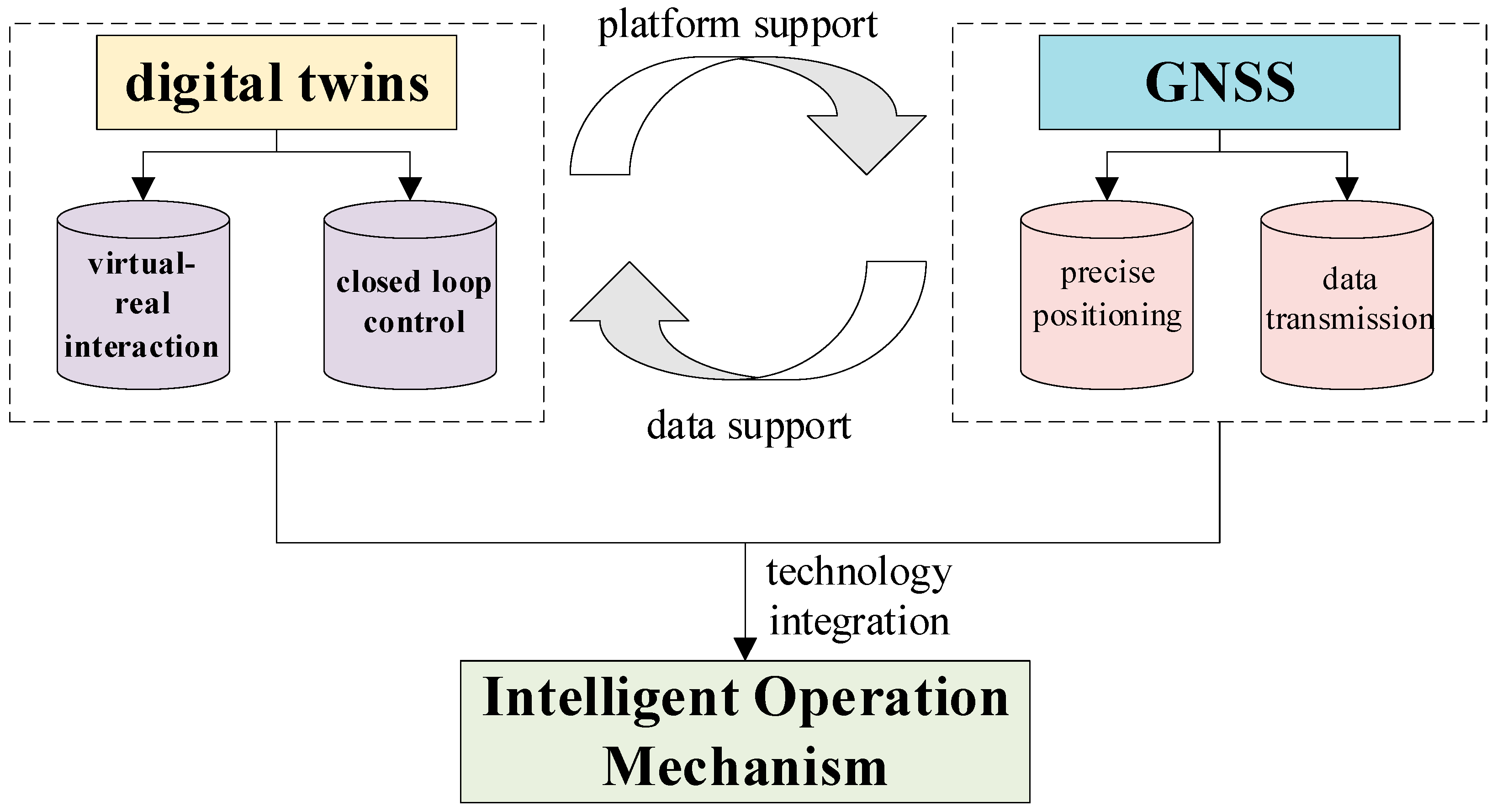
DTs could be used as the basis and platform of intelligent building O&M to provide technical integration and realize virtual–real mapping and closed-loop control of O&M processes. GNSS could capture precise position information of large building facilities (e.g., large stadiums) and provide data transmission channels for a huge amount of O&M data and information. Integrated use of GNSS and DTs could help to achieve real-time acquisition and accurate analysis of O&M data during tedious building O&M processes. For example, the interactive architectural twins established through DTs provides a platform for various applications of GNSS technology, and GNSS provides data support for the construction of DTs architecture. In addition, through the analysis of building O&M information, the control measures could be fed back to the actual building O&M processes. Such an integration could thus promote the intelligent control of tedious building O&M processes.
To achieve this goal, this study aims at identifying (1) data and information needed for intelligent O&M, and (2) challenges when applying DTs in intelligent O&M. Driven by DTs, the visualization of O&M process, intelligent diagnosis, and prediction of various risky O&M events could be realized for supporting the decision-making under numerous O&M scenarios. At the same time, GNSS uses the instantaneous position of the high-speed moving satellite as the known starting data to determine the position of the measuring point [26]. Indoor GNSS system based on an RF wave carrying GNSS signal could realize indoor high precision positioning. In the outdoor environment, the GNSS system can realize a series of auxiliary intelligent O&M functions such as precise navigation and intelligent measurement [27]. Hence, a fusion mechanism is formed based on the technical characteristics of DTs and GNSS (see Figure 3).
In the whole O&M process, various types of information are collected and managed through the integration of DTs and GNSS. All kinds of information in real physical space are collectively called I p , and its mathematical language is expressed as Formula (2).
I p = ( B p P p E p ) = ( B p 1 P p 1 E p 1 B p 2 P p 2 E p 2 B p m P p n E p w )
In Formula (2), B p , P p , and E p represent the information of buildings, people, and environment in physical space. B p 1 , B p 2 B p m represents the information of each component unit of the building itself in the physical space. P p 1 , P p 2 P p n represents the personal information involved in the O&M process in physical space. E p 1 , E p 2 E p w represents the information of various environmental factors in the physical space. For the information of physical space, GNSS technology is used to collect and transmit the location information of various elements. At the same time, the simulation of various types of information is carried out in the virtual space, thus forming the DTs information ( I D T ), whose mathematical language is expressed as Formula (3).
I D T = ( B D T P D T E D T ) = ( B D T 1 P D T 1 E D T 1 B D T 2 P D T 2 E D T 2 B D T m P D T n E D T w )
In Formula (3), B D T , P D T , and E D T represent the DTs information of architecture, personnel, and environment formed by virtual–real interaction. B D T 1 , B D T 2 B D T m represents the information of each component unit of the building itself in the twin space. P D T 1 , P D T 2 P D T n represents the personal information involved in the twin space. E D T 1 , E D T 2 E D T w represents the information of various environmental factors in twin space. Simulation analysis of various O&M events can be carried out in the DTs space. Given the O&M accidents, the auxiliary formulation of correction decisions can be carried out, and the feasibility analysis can be carried out in the virtual model. Finally, the precise positioning function of GNSS is used to effectively guide the maintenance of physical space. The resulting information ( I ) is expressed as Formula (4).
I = ( B P E ) = ( B 1 P 1 E 1 B 2 P 2 E 2 B m P n E w )
In Formula (4), B , P , and E represent the DTs information of buildings, personnel, and environment after maintenance. B 1 , B 2 B m represents the information of each component unit of the building itself after maintenance. P 1 , P 2 P n represents the personal information after maintenance. E 1 , E 2 E w represents the information of various environmental factors after maintenance.

2. Method

2.1. Intelligent Building O&M Control Based on GNSS–DTs

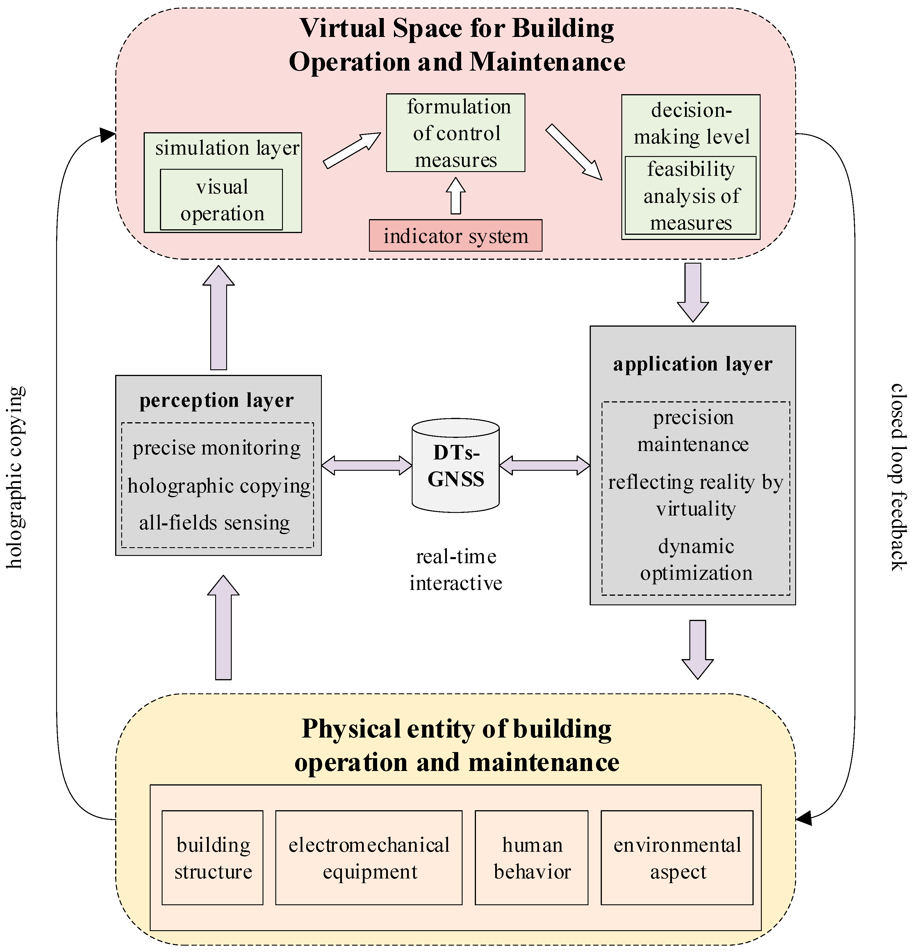
DTs are a key prerequisite for intelligent O&M. By integrating GNSS and DTs, the information fusion and interaction between the virtual space and physical space can be realized. The feedback information of virtual space can be transmitted to the physical space in real time, to realize the full physical space mapping, the dynamic modeling of the whole life cycle, the real-time information interaction of the whole process, and the full-stage feedback control of the construction O&M.

2.1.1. Theoretical Framework of Intelligent O&M

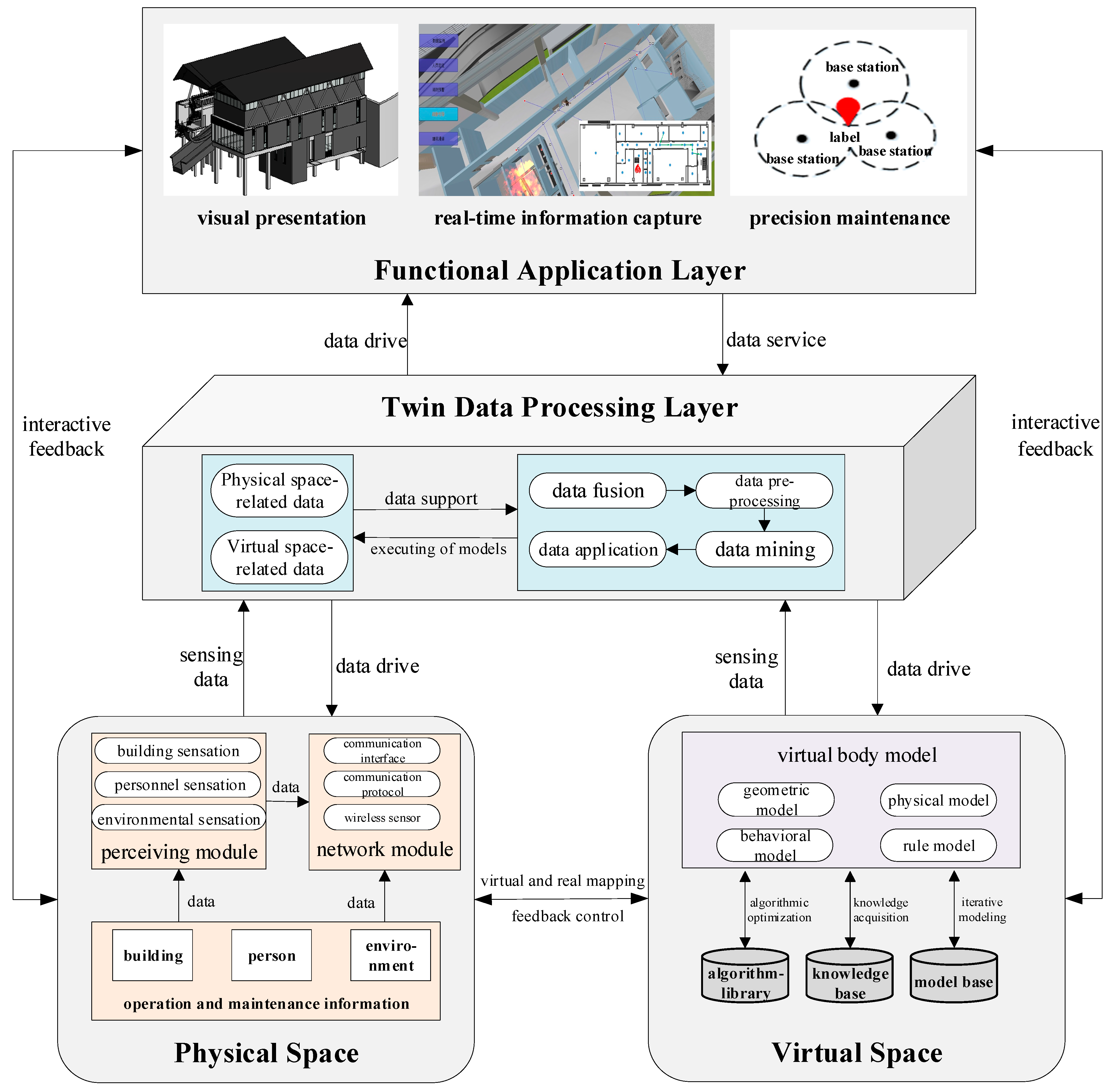
The intelligent O&M framework based on GNSS–DTs (see Figure 4) includes physical space, virtual space, information processing layer, and system layer. The established framework includes various relationships between multiple levels. For example, the physical space provides multi-source heterogeneous data of various O&M processes and transmits data to virtual space in real-time. The virtual space completes the mapping from the physical space to the virtual space by establishing all virtual models corresponding to the physical space. The interaction, calculation, and control attributes of the virtual space could realize the real-time feedback control of the whole process of physical space O&M. The big data storage management platform receives data from physical space and virtual space and performs a series of data processing operations to improve the accuracy, integrity, and consistency of data to support decision-making for regulating O&M activities. The intelligent O&M system platform based on GNSS–DTs carries out intelligent decision-making and functional regulation of O&M management by analyzing the actual needs of physical space, relying on the support of virtual space algorithm library, model library, and knowledge base, and the powerful data processing ability of the information layer.

2.1.2. Multidimensional Model Establishment for Intelligent O&M

Based on the architecture of intelligent O&M, a multidimensional model for intelligent O&M is established. In the physical space, by capturing the total factor information of O&M, the dynamic perception module based on GNSS is established [28] to collect the information of buildings, personnel, and environment, and form an information network module for standardized data transmission. At the same time, in the virtual space, a virtual model integrating “geometry–physics-behavior-rule” is established. The optimization algorithm and standard are modified in real time to realize the interactive mapping and feedback control of virtual and real space. Twin data are formed from physical space and virtual space. In the twin data processing layer, data fusion, data preprocessing, data mining, and data application are carried out to drive the O&M of intelligent twins. Finally, the O&M process is visualized in the functional application layer, and the O&M information is captured in real time to intelligently guide the O&M decision. The multidimensional model for intelligent O&M is represented by Formula (5).
DTM = (Sp, Sv, Ptd, Lfa, Cn)
In the formula, DTM is a multidimensional model for intelligent O&M; Sp is the physical space; Sv is the virtual space; Ptd is a twin data processing layer; Lfa is the functional application layer; Cn is a connection between components. The multidimensional model can realize the simulation mapping of the actual O&M process, and then intelligently analyze the state of each element information and make accurate maintenance decisions on the O&M site. The multidimensional model for intelligent O&M is shown in Figure 5.

2.2. Implementation of Intelligent O&M

By analyzing the key issues when applying DTs to intelligent O&M, a theoretical framework of intelligent O&M is built by integrating GNSS with DTs. Aiming at the implementation method of the established intelligent O&M framework, this section explored the acquisition and transmission mechanism of DTs-driven intelligent O&M full factor information, the construction and operation mode of O&M twin agents, and the storage and management of data, and builds an intelligent O&M platform based on GNSS–DTs.

2.2.1. Capture of Dynamic Data for Intelligent O&M

In the process of O&M of large and complex buildings, data sources mainly relate to construction, personnel, and environment. Data acquisition refers to the use of a device to automatically collect data from the object to the computer. The data acquisition methods used in the O&M process mainly include (1) generating barcode or two-dimensional code containing information for the object to be tested and obtaining object information by using the matching scanning equipment, (2) installing sensors on the test object, and the data acquisition instrument converts the analog signal transmitted by the sensor into a digital signal to the computer.
The physical space during O&M processes is a complex and dynamic environment. Such a space usually includes various information elements, perception modules, and network modules that may affect O&M. The data related to construction, personnel, and environment are the most primitive data sources. In addition, the multi-source heterogeneous data generated in O&M activities are transmitted to virtual space, while receiving instructions from virtual space and responding accordingly. The sensing module and the network module are responsible for data sensing acquisition and data transmission to the virtual space, respectively. The sensing module performs state sensing, quality sensing, and position sensing through different types of sensors installed on the building structure or mechanical and electrical equipment and collects multi-source heterogeneous data. On this basis, by establishing a set of standard data interfaces and communication protocols in the network module, the unified conversion and transmission of data from different sources are realized, and the real-time data of O&M activities are uploaded to the virtual space. Thus, the acquisition and transmission mechanism of all-factor information for intelligent O&M is formed.
The information collection and transmission (Ict) of all elements of intelligent O&M includes four levels: physical object, data type, perception layer, and network layer. The mathematical language is expressed by Formula (6).
Ict = (Po→Dt→Lp→Ln)
In this equation, Po represents the relevant information of the physical object that needs to be captured, mainly including the “building, personnel, environment” information; Dt represents the type of data, mainly including the multi-source heterogeneous data generated in the O&M process and its corresponding data format; Lp represents the sensing layer, mainly through GNSS, RFID, and other Internet of Things sensing equipment for real-time data acquisition and transmission; Ln represents the network layer, which mainly includes communication interfaces and communication protocols, providing data support for twin agents; → represents the progressive connection between the various levels, reflecting the flow of information collection and transmission.

2.2.2. Construction and Operation of the O&M Twin Agent

Under the background of the development of autonomous intelligence, especially agent technology, the modeling of twin agents in the O&M system has new ideas and methods [29]. Based on autonomous intelligent technology and fully considering the two dimensions of time and space, in the spatial dimension (R), the construction information (B), personnel information (P), and environmental information (E) of intelligent O&M are constructed by integrating DTs technology, to realize the multi-scale modeling of the vertical dimension of the O&M system. In the time dimension (T), around the whole O&M process, the time evolution data before event maintenance (T1), during event maintenance (T2), and after event maintenance (T3) are fused to establish a dynamic collaborative operation mechanism based on twin agents, which supports the virtual–real interactive configuration modeling of intelligent O&M and the modeling of intelligent O&M process in a multi-dimensional and multi-scale time-space domain, and realizes the time-history parallel simulation and virtual–real integrated control of multi-element, multi-process, and multi-service of intelligent O&M system. The O&M twin agent (TA) modeling based on spatiotemporal information fusion is represented by Formula (7).
T A = ( R T ) = ( B P E T 1 T 2 T 3 )
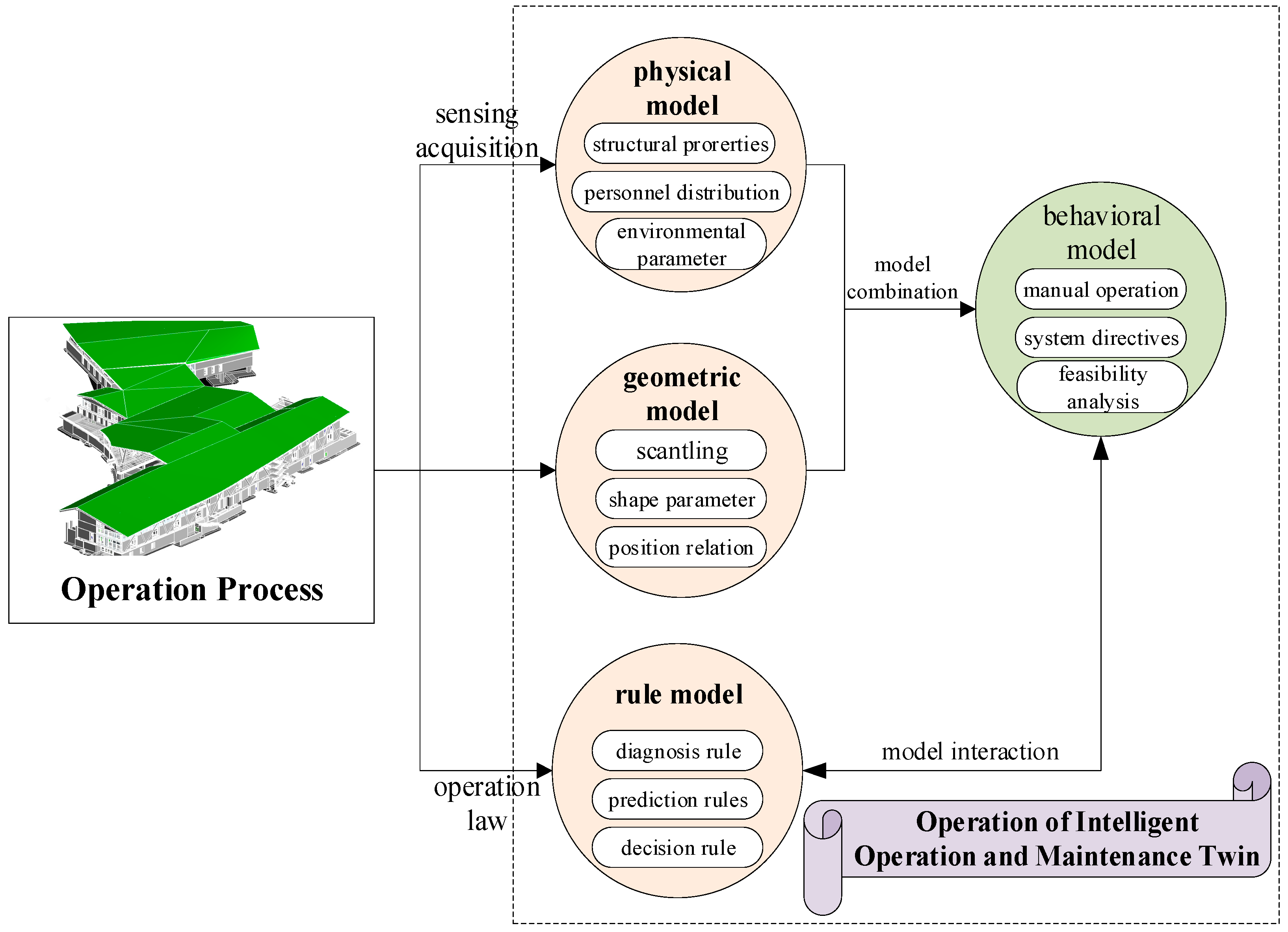
Based on twin agent modeling, a deep fusion of multiple models, including geometry, physics, behavior, and rule models, is formed as a “digital mirror” to truly reflect the process of physical entities. First, the geometric modeling is carried out in the virtual space, which reflects the geometric information of the size, shape, and position of the physical space, and forms a “three-dimensional model”. Then, the information reflecting the physical properties of the entity is collected by multi-type sensors installed in the physical space, and the physical modeling is carried out, including structural performance, equipment status, personnel distribution, and environmental parameters. The collected physical attribute information is fused with the three-dimensional model, and the model behavior and response ability are given. Behavior modeling can make corresponding response and feasibility analyses for manual operation or system instructions in the O&M process. Finally, the rules of O&M of physical entities are modeled, including diagnostic rules, prediction rules, decision rules, etc., and associated with the behavior model. Finally, the efficient operation of twin agents for O&M is realized, as shown in Figure 6.

2.2.3. Analysis of Intelligent O&M Data

Twin data storage and management platform (Psm) is a bridge between physical space and virtual space, including data fusion (Df), data preprocessing (DP), data mining (Dm), and data application (Da), four steps. The storage and management of intelligent O&M twin data are represented by Formula (8).
Psm = (Df, Dp, Dm, Da)
Massive multi-source heterogeneous raw data from physical space and virtual space are collected and fused in real time by GNSS and other sensing technologies. These data include the O&M factor data of physical space, as well as the model data, simulation data, management data, and evaluation data of virtual space. Then, these raw data are preprocessed, including data cleaning, data integration, data conversion, and data specification, to improve the accuracy, integrity, and consistency of data. An AI algorithm is used for data analysis and mining to achieve the effect of classification, prediction, and clustering. Finally, based on data fusion, preprocessing, analysis, and mining, the corresponding parameters are extracted from the database and knowledge base for data application at feature level and decision level, to be the decision basis for regulating construction activities.
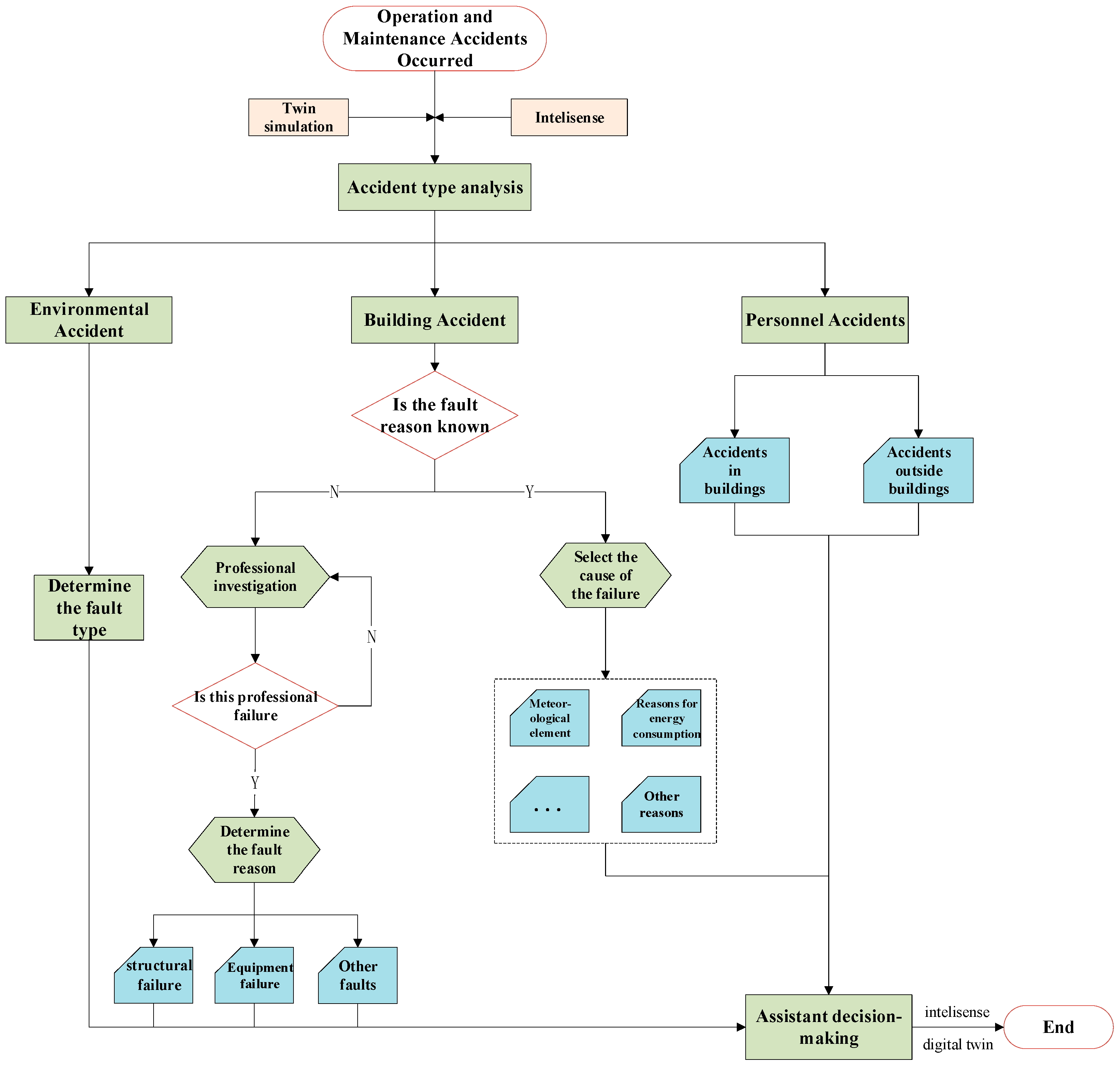
In the process of O&M, when an O&M accident occurs, the type of O&M accident is evaluated, and root causes of events can be analyzed through simulation of virtual model and precise positioning of GNSS in physical space. Finally, the O&M accidents are rectified under the feasibility analysis of the virtual model and the precise positioning of GNSS [30] to ensure the orderly O&M. The management process of building O&M accidents based on GNSS–DTs is shown in Figure 7.

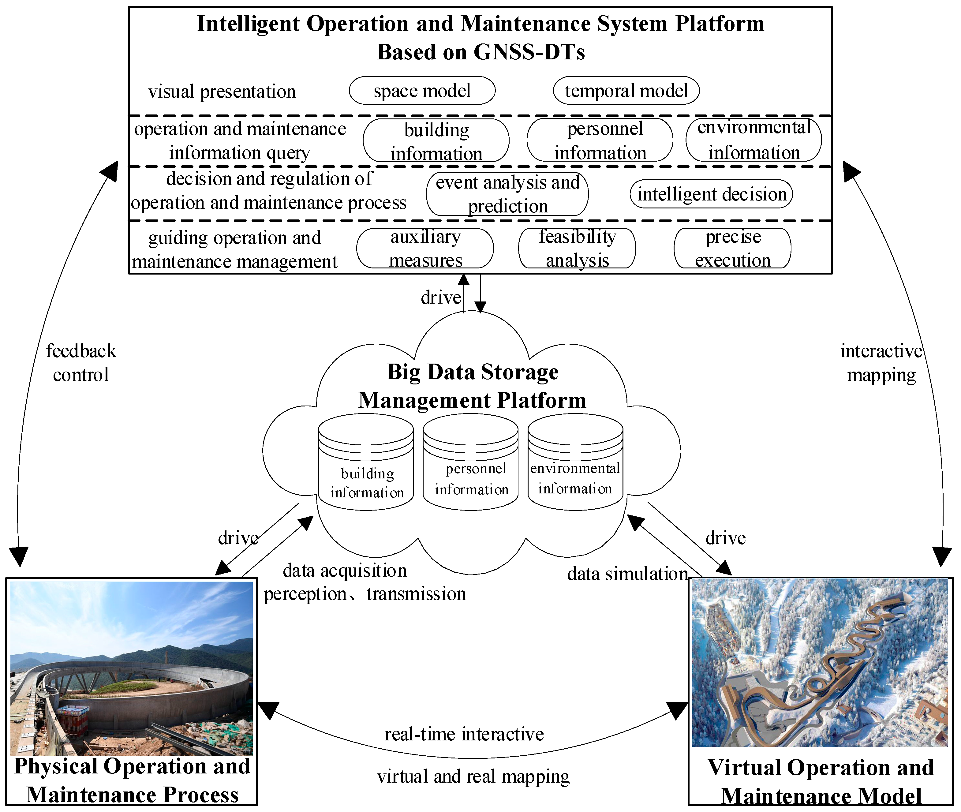
2.2.4. Intelligent O&M Decision-Making and Control Platform

Establishing the O&M platform requires the integrated use of GNSS and DT. Such a platform requires (1) the collection and transmission of O&M data, (2) the construction and operation of twin agents, and (3) and the storage and management of twin data. GNSS and DTs are organically integrated, and an intelligent O&M platform is established. By analyzing the actual needs of physical space, relying on the support of virtual space algorithm library, model library and knowledge base, and the powerful data processing ability of the information layer, the intelligent O&M platform based on GNSS–DTs makes decisions on various events encountered in the O&M process and the state of the building itself, personnel and environment, to realize functional regulation. The specific functions include real-time monitoring of O&M elements, state intelligent diagnosis, risk alarming system, automatic monitoring, auxiliary O&M decision-making, feasibility analysis, etc., and real-time optimization control of the whole O&M process. The twin data of O&M information are formed by interactive mapping between physical space and virtual space. According to the twin data, the real-time monitoring of the O&M process is carried out, the state of various O&M objects is intelligently diagnosed, the location of the problem is scientifically warned, and the timely remedy or auxiliary decision is made. The feasibility analysis of the auxiliary decision-making is carried out in the virtual space to output the correct measures and guide the O&M of the real physical space combined with the human–computer interaction system in the O&M process. At the same time, the information after maintenance is continuously analyzed in real time, thus forming an intelligent closed-loop control of the O&M process. The architecture of an intelligent O&M platform based on GNSS–DTs is shown in Figure 8.

3. Results

3.1. Case Study

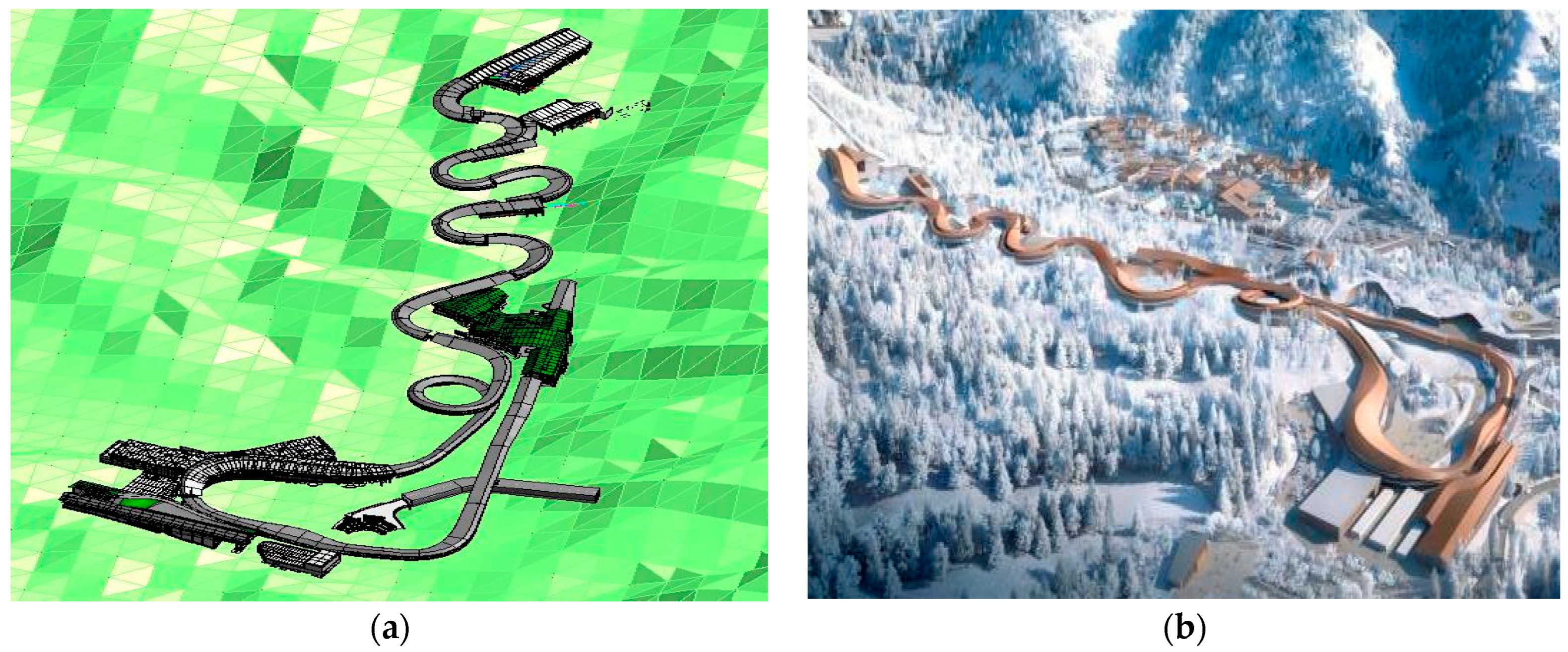
Based on the analysis of the theoretical system and implementation method of intelligent O&M, the authors have carried out a case study and applied the developed GNSS–DTs-based green O&M platform to the 2022 Beijing Winter Olympic Sled Venues. The snowmobile sled stadium of the Beijing Winter Olympic Games is located in the Xiaohaituo Mountain area of Yanqing District, Beijing. The stadium is one of the most complex competition venues in the design and construction of the new projects of the Beijing Winter Olympic Games in 2022. The track is built according to the mountain trend, with a total length of about 2000 m and a vertical drop of more than 120 m. Sixteen bends with different inclinations and angles are designed. After the completion of the track, it will become China’s first snowmobile sled track. The stadium is also one of the most difficult venues in the world so far (see Figure 9).
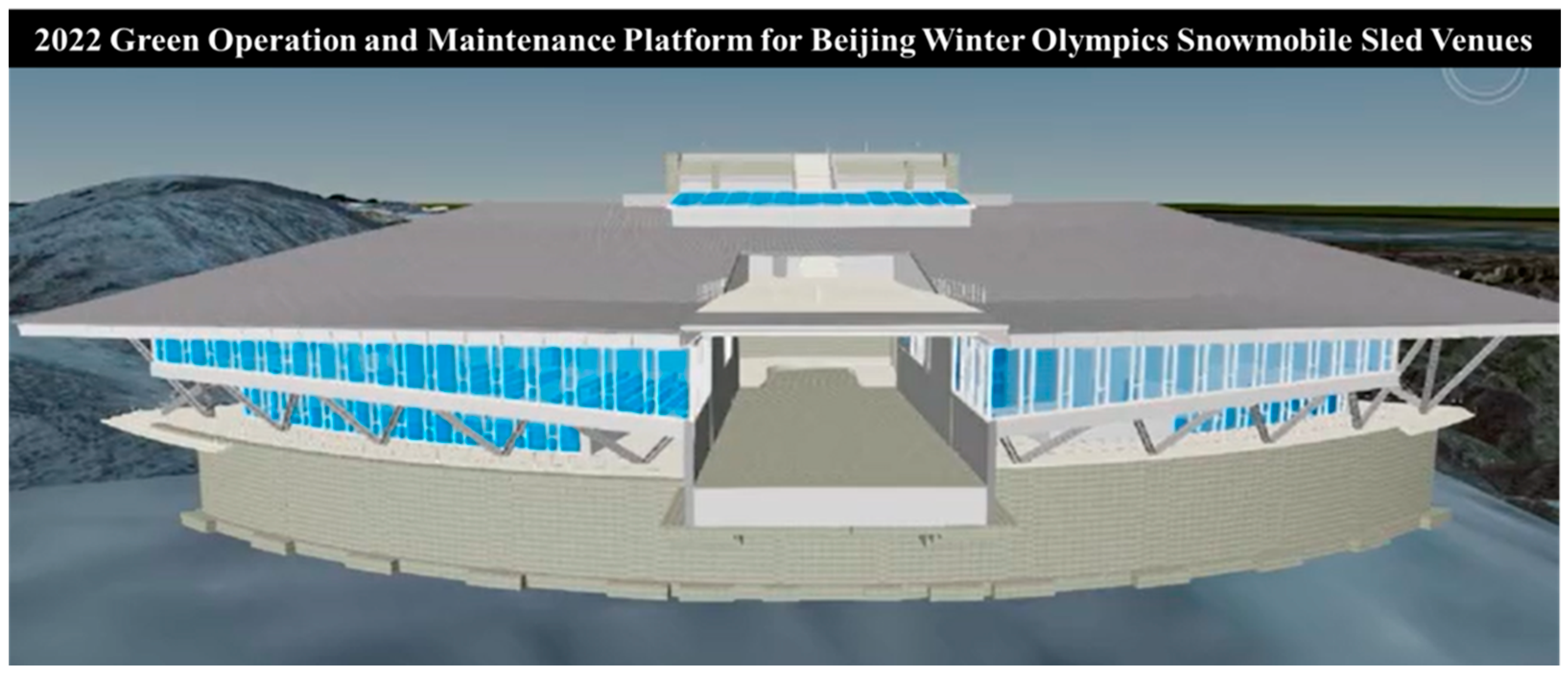
The development of the GNSS–DTs-based green O&M platform (see Figure 10) makes the O&M management object and management work more vivid and direct. The developed platform can help to carry out visual management of building O&M simply and effectively and obtain the information of building O&M management more accurately, comprehensively, and quickly. In addition, the platform could help to carry out the collaborative management of building O&M more effectively, improve the maintenance efficiency, reduce the overall maintenance cost, and make up for the shortcomings of traditional O&M management. The overall goal of the developed platform is to achieve the integration of O&M management, intelligence, and information technology for improving conventional management.

3.2. Technical Architecture of O&M Platform

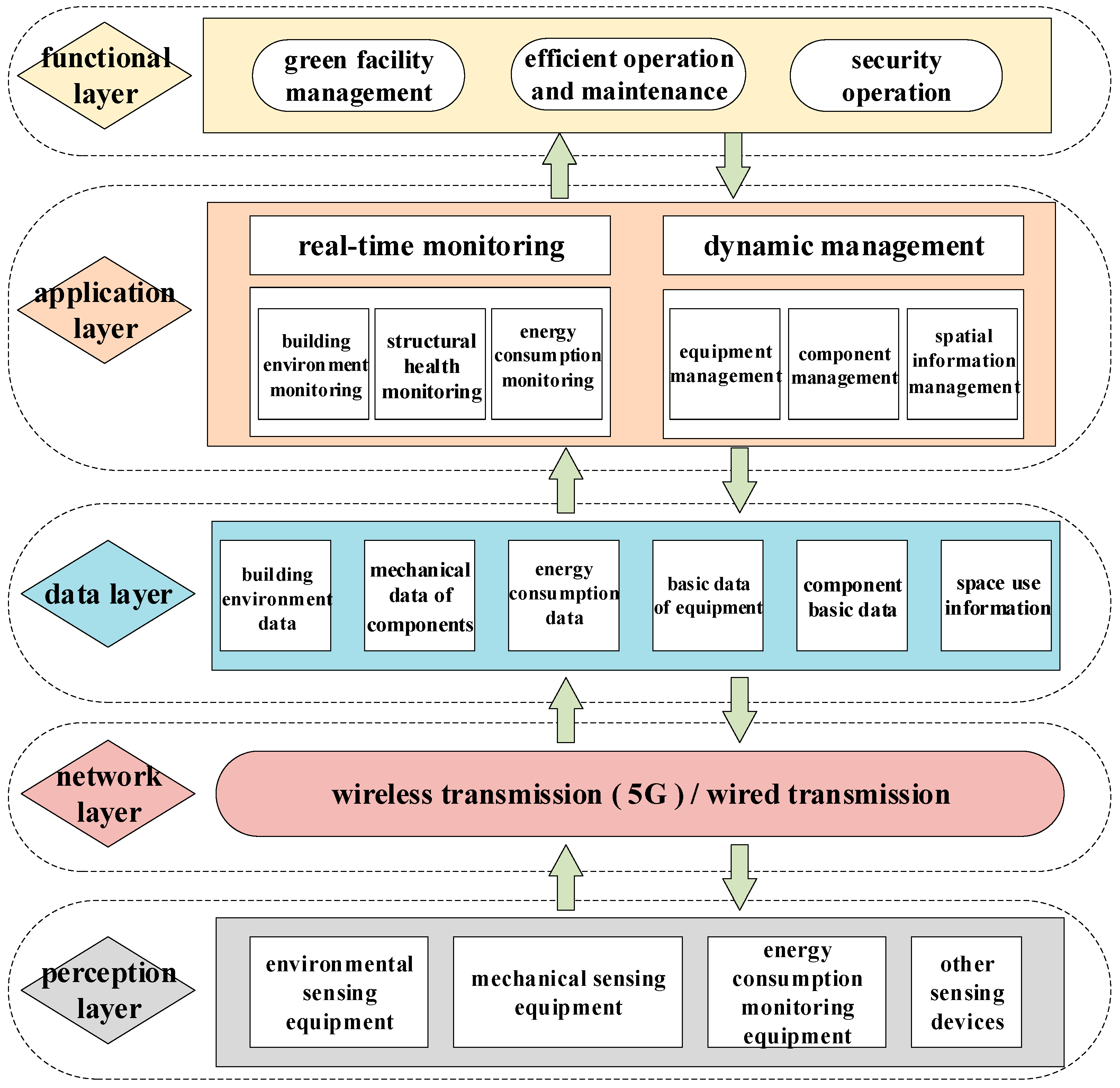
Combined with the configuration of the function modules of the O&M platform, the technical architecture of the O&M platform is established, as shown in Figure 11. The authors have established the platform by following the sequence of the functional layer, platform layer, data layer, network layer, and physical layer. The overall goal of this platform includes three objectives to achieve: (1) green O&M, (2) efficient O&M, and (3) safe O&M.
The construction of a green O&M platform based on GNSS–DTs could integrate the information of each stage of the project. Through the development of project design management and operation management module, software engineering technology is used to realize building visualization, resource sharing, and simple and efficient operation to reduce change orders during projects and facilitate O&M management.
In the perception layer, the real-time acquisition of O&M information is carried out by various sensing devices, and the precise positioning of equipment and components and real-time mapping of virtual models are carried out by GNSS. For multi-source heterogeneous data, the network layer transmits data to the data layer, and the data layer integrates project twin data in the O&M phase and stores them in the database. The data source could be divided into two parts, the simulation data and field measured data, a synchronization project to carry out the continuous dynamic update. The real-time monitoring and dynamic management of O&M information are carried out combined with the functional modules of the O&M system, and the precise guidance of GNSS technology in the application layer is carried out to improve the efficiency of O&M. Finally, the three goals of green O&M, efficient O&M, and safe O&M are realized.

3.3. Implementation Strategy of Intelligent O&M

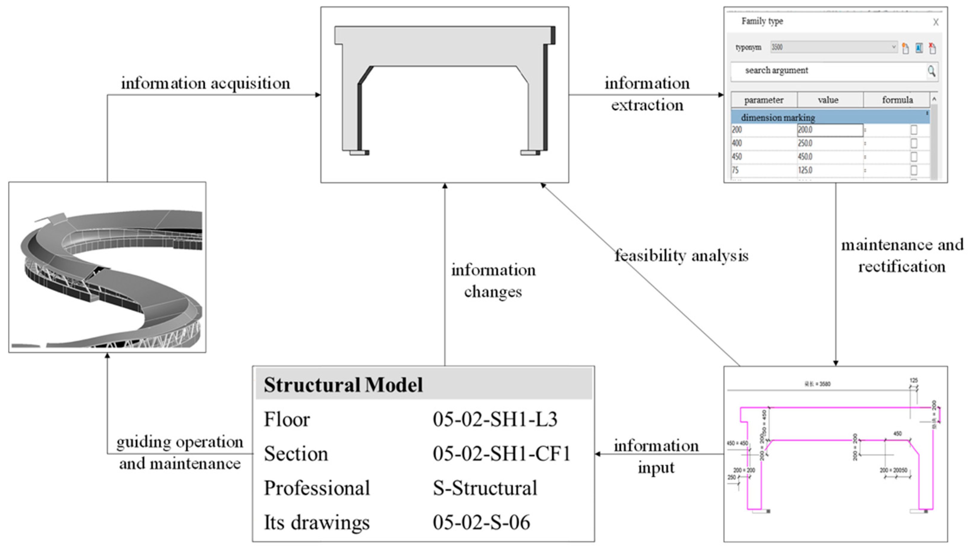
The authors carried out specific O&M management applications based on the technical architecture of the O&M platform. Taking the building structural components in the venues as an example, the intelligent O&M application system of components is formed (Figure 12). According to the analysis of mechanical parameters of structural members in the design process, the corresponding acquisition modules are arranged at the positions of special-shaped structural members and turning points. Building structural components are outdoors, which helps to receive signals, and has little effect on the accuracy of position information acquisition. The GNSS automatic positioning system applied in this study is mainly composed of hardware system (sensor module, data acquisition module, and data transmission module) and software system (database module, data processing, and control module). The system collects GNSS signals of monitoring points and base points in real time and sends them to the control center through the data transmission module. The three-dimensional coordinates of each monitoring point are calculated by real-time difference decomposition of the data processing module. The real-time collected data are applied to the twin model of the building through the software system. Finally, when the O&M accident occurs, the system platform directs maintenance guidance. According to the component characteristics of the O&M site, the data are collected by the precise positioning of the GNSS. In addition, the correspondent twin model is taken out in the O&M platform. The O&M management information is extracted, and the operation state is evaluated, to examine whether maintenance is needed. Thus, the components with operation parameters exceeding the limit are corrected to ensure the reliability of the operation. At the same time, the corrective measures are imported into the twin model of the O&M platform for feasibility analysis. Finally, the maintenance decision is formed, and the updated information is input. The auxiliary positioning function of GNSS technology guides the O&M of the site in order to verify the accuracy of mechanical parameters monitoring of structural components based on the GNSS–DTs green O&M platform. Taking the stress of a special-shaped component as an example, the data analyzed by the O&M platform are compared with the data collected by the field sensors in the process of building O&M. The comparison shows that the O&M platform realizes the precise positioning of structural coordinates, and the mechanical parameters analyzed are consistent with the values collected on the spot. The green O&M platform based on GNSS–DTs provides reliable support for the structural health monitoring of Winter Olympic venues.
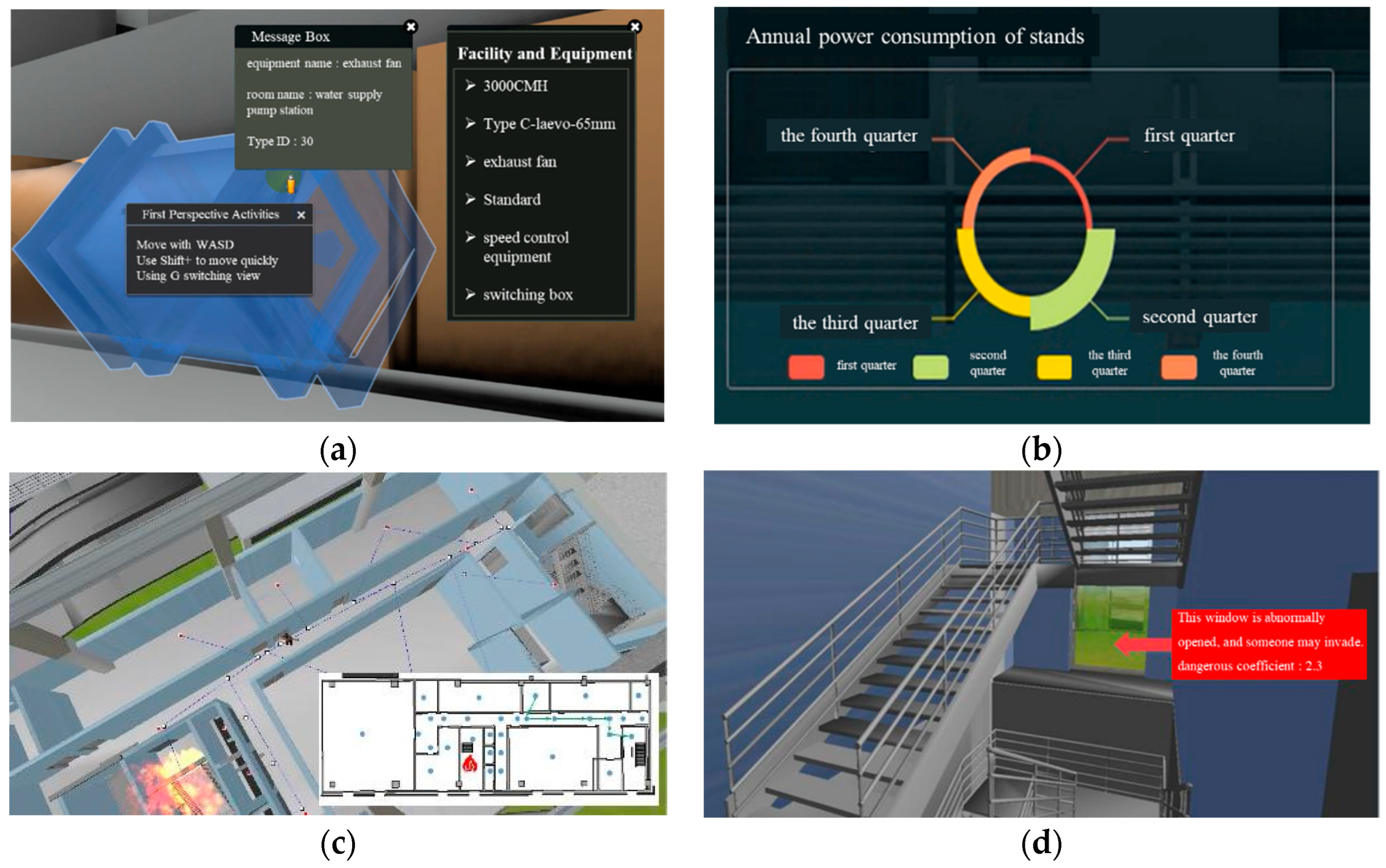
The application system of intelligent O&M could achieve (1) visual presentation of each element information in the building, (2) intelligent diagnosis of running state, and (3) alarming of anomalous parameters. Finally, the maintenance decision can be generated to guide the whole O&M process. The intelligent closed-loop control for building O&M is formed, which is convenient for O&M management and makes maintenance measures quickly and accurately. In the O&M of the 2022 Beijing Winter Olympics sled stadium, the intelligent technology system is also applied to various O&M processes (see Figure 13), such as (1) equipment management system, (2) energy consumption monitoring system, (3) emergency treatment system, and (4) risk alarming system.

4. Discussion and Conclusions

This study proposed and implemented a GNSS–DTs-based method for tackling various challenges existing during tedious building O&M control processes. The proposed method integrates DTs with the precise positioning function of GNSS for achieving intelligent control of building O&M processes. In the process of O&M, DTs can realize real-time mapping of building state, intelligently analyze the state of each factor, and predict the future development trend of each factor. The application of DTs in intelligent O&M also needs to solve four key problems: data acquisition and transmission, data modeling, data analysis, and data application. GNSS captures the three-dimensional coordinates of various elements in real time, assisting the establishment of the twin model and providing the data basis. On the other hand, when the building information is abnormal in the twin model, it can be maintained by GNSS high-precision positioning. With the integration of digital twin and GNSS, an intelligent building operation and maintenance method is formed. Aiming at the problems to be solved, a closed-loop control model is built from transmission to analysis management, and finally the maintenance decision is realized.
In this study, the main conclusions are as follows:
(1)
The authors synthesized major information elements that need to be captured in intelligent building O&M processes according to real construction practice. In addition, the authors summarized major challenges when implementing DTs and GNSS for controlling tedious building O&M processes. The authors systematically explored the fusion mechanism of GNSS and DTs based on the identified four challenges.
(2)
The authors proposed a framework by integrating GNSS and DTs for achieving intelligent building O&M control based on the established fusion mechanism. In addition, a multidimensional model for intelligent building O&M is built, which forms the theoretical framework of intelligent building O&M based on GNSS–DTs.
(3)
The authors explored an implementation method for implementing the proposed intelligent building O&M framework. An intelligent building O&M information capture mechanism is formalized, an O&M-based DTs agent is built, an analysis mode of intelligent O&M is provided, and the intelligent O&M decision control platform is finally proposed.
(4)
Based on the theoretical framework and implementation method, the authors developed a green building O&M platform. The established platform integrates multiple functional modules according to the building O&M characteristics of the 2022 Beijing Winter Olympics snowmobile sled venue. By analyzing the technical architecture and application system of the established building O&M platform, the proposed theoretical method could realize the intelligent closed-loop management of building O&M processes.
In the process of O&M, the data analyzed by the O&M platform are compared with the data collected by the field sensors in the process of building O&M. The results show that the analysis results of the platform are consistent with the field-measured values, and the effectiveness of the intelligent O&M method based on GNSS–DTs is verified. Based on the platform formed by this research method, the ultimate goal is to realize the green low-carbon O&M of Winter Olympic venues.
For the intelligent O&M of buildings, the collection, modeling, management, and application of multi-source information are the key problems to overcome. Accurate analysis and scientific prediction of various events by considering the state changes of various factors in the operation and maintenance process are the key points to guide the O&M management. The integration of digital twin and GNSS and other intelligent sensing technologies provides methods and ideas for the realization of intelligent O&M. Future studies could focus on the integration of information technologies, such as the IoTs, to achieve integrated analysis of multiple control factors (e.g., cost, schedule) based on the concept of DTs in various building O&M processes.

Author Contributions

Conceptualization, Z.L.; methodology, Z.L.; software, Z.L.; validation, Z.L., G.S., X.M. and Z.S.; writing—original draft preparation, G.S.; writing—review and editing, Z.L.; project administration, Z.L.; funding acquisition, Z.L. All authors have read and agreed to the published version of the manuscript.

Funding

The research was funded by Research on Sensor and Source Data News Ecological Engineering (grant number 40004015202114).

Institutional Review Board Statement

Not applicable.

Informed Consent Statement

Not applicable.

Data Availability Statement

The data presented in this study are available on request from the corresponding author. The data are not publicly available due to the confidentiality.

Acknowledgments

The authors would like to thank Beijing University of Technology, Beijing, China, for their support throughout the research project.

Conflicts of Interest

The authors declare no conflict of interest. The funders had no role in the study’s design; in the collection, analyses, or interpretation of data; in the writing of the manuscript or in the decision to publish the results.

References

  1. Mohammadi, S.; Tavakolan, M.; Zahraie, B. An intelligent simulation-based framework for automated planning of concrete construction works. Eng. Constr. Archit. Manag. 2021. ahead-of-print. [Google Scholar] [CrossRef]
  2. Davari, M.; Aghababa, M.P.; Blaabjerg, F.; Saif, M. An Innovative, Adaptive Signal Rectifier along with a Switching Controller for Reliable Primary Control of GC-VSIs in CPS-Based Modernized Microgrids. IEEE Trans. Power Electron. 2020, 36, 8370–8387. [Google Scholar] [CrossRef]
  3. Jian-wei, W.A.; Chao, G.; Shi, D.; Sheng, X.U.; Chang-wei, Y.U.; Chi, Z.H.; Ze-bin, H.U.; Shan-shan, B.U.; Qing, C.H.; Yue, W.A. Current Status and Future Prospects of Existing Research on Digitalization of Highway Infrastructure. China J. Highw. Transp. 2020, 33, 101–124. [Google Scholar]
  4. Cavka, H.B.; Staub-French, S.; Poirier, E.A. Developing owner information requirements for BIM-enabled project delivery and asset management. Autom. Constr. 2017, 83, 169–183. [Google Scholar] [CrossRef]
  5. Hu, Z.Z.; Leng, S.; Yuan, S. BIM-based, data-driven method for intelligent O&M. J. Tsinghua Univ. (Sci. Technol.) 2022, 62, 199–207. [Google Scholar]
  6. Nativi, S.; Mazzetti, P.; Craglia, M. Digital Ecosystems for Developing Digital Twins of the Earth: The Destination Earth Case. Remote Sens. 2021, 13, 2119. [Google Scholar] [CrossRef]
  7. Liu, Z.; Shi, G.; Jiang, A.; Li, W. Intelligent Discrimination Method Based on DTs for Analyzing Sensitivity of Mechanical Parameters of Prestressed Cables. Appl. Sci. 2021, 11, 1485. [Google Scholar] [CrossRef]
  8. Jiang, L.I.; Bai-gen, C.A.; Jian, W.A.; Ze-qian, Z.H. Dedicated Short-range-communication-aided Fault Detection Method for Satellite-based Vehicle Positioning. China J. Highw. Transp. 2021, 34, 265–281. [Google Scholar]
  9. Yang, Q.L.; Ma, Z.L.; Xing, J.C. An Extension Approach of Building Information Modeling to Cyber-Physical Systems. J. Tongji Univ. (Nat. Sci.) 2020, 48, 1406–1416. [Google Scholar]
  10. Duan, X.C.; La, H.X.; Hu, T.M. Research on the 3D Nonlinear Intelligent Control for Bridge Engineering O&M Cost. J. Railw. Eng. Soc. 2020, 37, 102–107. [Google Scholar]
  11. Song, Z.P.; Shi, G.L.; Wang, J.B. Framework of collaborative management platform for tunnels based on BIM technology. Chin. J. Geotech. Eng. 2018, 40, 117–121. [Google Scholar]
  12. Chen, C.; Tang, C. BIM-based integrated management workflow design for schedule and cost planning of building fabric maintenance. Autom. Constr. 2019, 107, 102944. [Google Scholar] [CrossRef]
  13. Kim, K.; Kim, H.; Kim, W.; Kim, C.; Kim, J.; Yu, J. Integration of ifc objects and facility management work information using Semantic Web. Autom. Constr. 2018, 87, 173–187. [Google Scholar] [CrossRef]
  14. Belussi, L.; Barozzi, B.; Bellazzi, A.; Danza, L.; Devitofrancesco, A.; Fanciulli, C.; Ghellere, M.; Guazzi, G.; Meroni, I.; Salamone, F.; et al. A review of performance of zero energy buildings and energy efficiency solutions. J. Build. Eng. 2019, 25, 100772. [Google Scholar] [CrossRef]
  15. Liu, Z.; Shi, G.; Zhang, A.; Huang, C. Intelligent Tensioning Method for Prestressed Cables Based on DTs and Artificial Intelligence. Sensors 2020, 20, 7006. [Google Scholar] [CrossRef] [PubMed]
  16. Lu, Q.; Parlikad, A.K.; Woodall, P.; Don Ranasinghe, G.; Xie, X.; Liang, Z.; Konstantinou, E.; Heaton, J.; Schooling, J. Developing a dynamic DT at building and city levels: A case study of the West Cambridge campus. J. Manag. Eng. 2019, 36, 05020004. [Google Scholar] [CrossRef]
  17. Liu, Z.; Zhang, A.; Wang, W. A Framework for an Indoor Safety Management System Based on DT. Sensors 2020, 20, 5771. [Google Scholar] [CrossRef]
  18. Marai, O.E.; Taleb, T.; Song, J.S. Roads Infrastructure DT: A Step Toward Smarter Cities Realization. IEEE Netw. 2020, 35, 136–143. [Google Scholar] [CrossRef]
  19. Kaewunruen, S.; Lian, Q. DT aided sustainability-based lifecycle management for railway turnout systems. J. Clean. Prod. 2019, 228, 1537–1551. [Google Scholar] [CrossRef]
  20. Peng, Y.; Zhang, M.; Yu, F.; Xu, J.; Gao, S. DT Hospital Buildings: An Exemplary Case Study through Continuous Lifecycle Integration. Adv. Civ. Eng. 2020, 2020, 8846667. [Google Scholar]
  21. Sakic, P.; Chupin, C.; Ballu, V.; Coulombier, T.; Morvan, P.Y.; Urvoas, P.; Beauverger, M.; Royer, J.Y. Geodetic Seafloor Positioning Using an Unmanned Surface Vehicle—Contribution of Direction-of-Arrival Observations. Front. Earth Sci. 2021, 9, 636156. [Google Scholar] [CrossRef]
  22. Iinuma, T.; Kido, M.; Ohta, Y.; Fukuda, T.; Tomita, F.; Ueki, I. GNSS-Acoustic Observations of Seafloor Crustal Deformation Using a Wave Glider. Front. Earth Sci. 2021, 9, 600946. [Google Scholar] [CrossRef]
  23. Coronado, P.D.; Lynn, R.; Louhichi, W.; Parto, M.; Wescoat, E.; Kurfess, T. Part data integration in the Shop Floor DT: Mobile and cloud technologies to enable a manufacturing execution system. J. Manuf. Syst. 2018, 48, 25–33. [Google Scholar] [CrossRef]
  24. Gao, X.; Pishdad-Bozorgi, P. BIM-enabled facilities O&M: A review. Adv. Eng. Inform. 2019, 39, 227–247. [Google Scholar]
  25. Barari, A.; de Sales Guerra Tsuzuki, M.; Cohen, Y.; Macchi, M. Editorial: Intelligent manufacturing systems towards industry 4.0 era. J. Intell. Manuf. 2021, 32, 1793–1796. [Google Scholar] [CrossRef]
  26. Fang, Z.; Yu, J.; Meng, X. Modal Parameters Identification of Bridge Structures from GNSS Data Using the Improved Empirical Wavelet Transform. Remote Sens. 2021, 13, 3375. [Google Scholar] [CrossRef]
  27. Basso, M.; Martinelli, A.; Morosi, S.; Sera, F. A Real-Time GNSS/PDR Navigation System for Mobile Devices. Remote Sens. 2021, 13, 1567. [Google Scholar] [CrossRef]
  28. Cheng, Q.; Chen, P.; Sun, R.; Wang, J.; Mao, Y.; Ochieng, W.Y. A New Faulty GNSS Measurement Detection and Exclusion Algorithm for Urban Vehicle Positioning. Remote Sens. 2021, 13, 2117. [Google Scholar] [CrossRef]
  29. Malik, J.; Elhayek, A.; Stricker, D. WHSP-Net: A Weakly-Supervised Approach for 3D Hand Shape and Pose Recovery from a Single Depth Image. Sensors 2019, 19, 3784. [Google Scholar] [CrossRef] [Green Version]
  30. Weng, D.; Ji, S.; Lu, Y.; Chen, W.; Li, Z. Improving DGNSS Performance through the Use of Network RTK Corrections. Remote Sens. 2021, 13, 1621. [Google Scholar] [CrossRef]
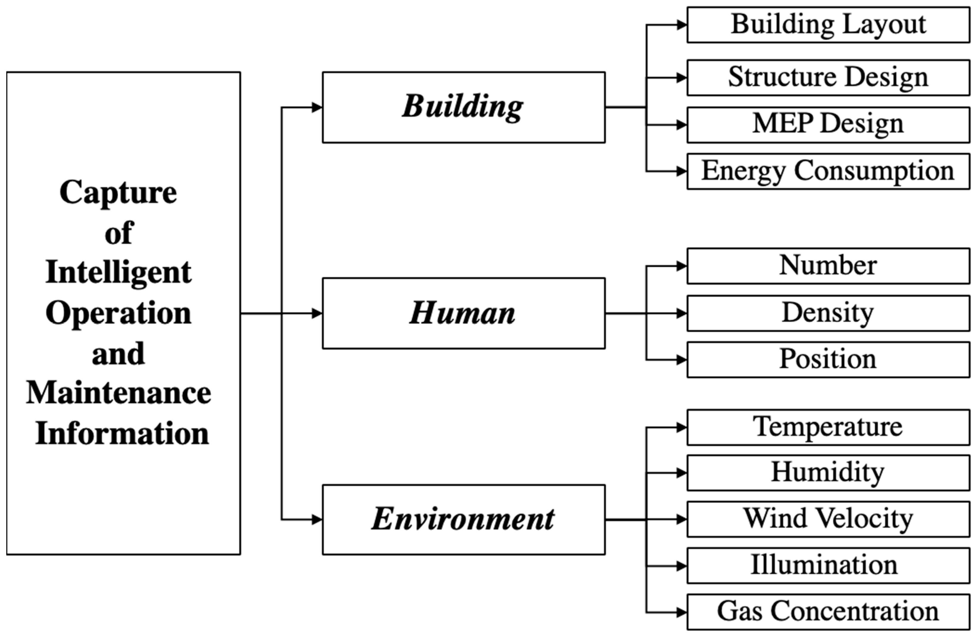
Figure 1. Intelligent O&M information capture system.
Remotesensing 14 01387 g001
Figure 2. Key issues of DTs application in intelligent O&M.
Remotesensing 14 01387 g002
Figure 3. Fusion mechanism of GNSS and DTs.
Remotesensing 14 01387 g003
Figure 4. Intelligent O&M architecture based on GNSS–DTs.
Remotesensing 14 01387 g004
Figure 5. Multidimensional model for intelligent O&M.
Remotesensing 14 01387 g005
Figure 6. Efficient operation of twin agents for O&M.
Remotesensing 14 01387 g006
Figure 7. Management process of building O&M accidents based on GNSS–DTs.
Remotesensing 14 01387 g007
Figure 8. Architecture of intelligent O&M decision control platform.
Remotesensing 14 01387 g008
Figure 9. Effect map of sports venues. (a) Combination of BIM and GIS; (b) twin model of venues.
Remotesensing 14 01387 g009
Figure 10. Green O&M platform for Beijing Winter Olympics snowmobile sled venues.
Remotesensing 14 01387 g010
Figure 11. Technical architecture of O&M platform.
Remotesensing 14 01387 g011
Figure 12. Intelligent O&M application system for building structure components.
Remotesensing 14 01387 g012
Figure 13. Application of intelligent building O&M technology system. (a) Equipment management system, (b) energy consumption monitoring system, (c) emergency treatment system, and (d) risk alarming system.
Remotesensing 14 01387 g013
Publisher’s Note: MDPI stays neutral with regard to jurisdictional claims in published maps and institutional affiliations.