1. Introduction
The NewSpace generation has devised new ideas to change the traditional space perspective, which is demanding with respect to resources and cost. The dynamics of the working potential of the satellites has been redefined, and new norms have been established with higher competence and upgraded satellite architectures.
Small satellites (under 500 kg) offer new potential for the space community, providing enhanced performance, and compact sizes. In addition to offering greater performance, these satellites generate confidence in manufacturers and users, thus ensuring their commercial value is retained, in addition to their purpose and durability. This also implies the saving of resources and millions of dollars spent each year to obtain the necessary data for real-time applications, such as disaster management and effective global warming control through continuous monitoring during the rescue and relief efforts.
Hence, the creative development of small satellites is needed, with the objective of solving issues on Earth, and the vision of applying and utilizing these satellites for deep-space operations. Due to the constraints of basic astrodynamics, the overall compact modeling of these satellites is challenging and demanding. Thus, greater innovation and updated algorithms are required to assist in swift data transfer and attain robust functioning capabilities over time.
Satellite constellations represent an upgrade from individual small satellites, and have been launched during the past decade. There has been immeasurable excitement among space enthusiasts with regard to the benefits they provide compared with traditional satellite launches and operations.
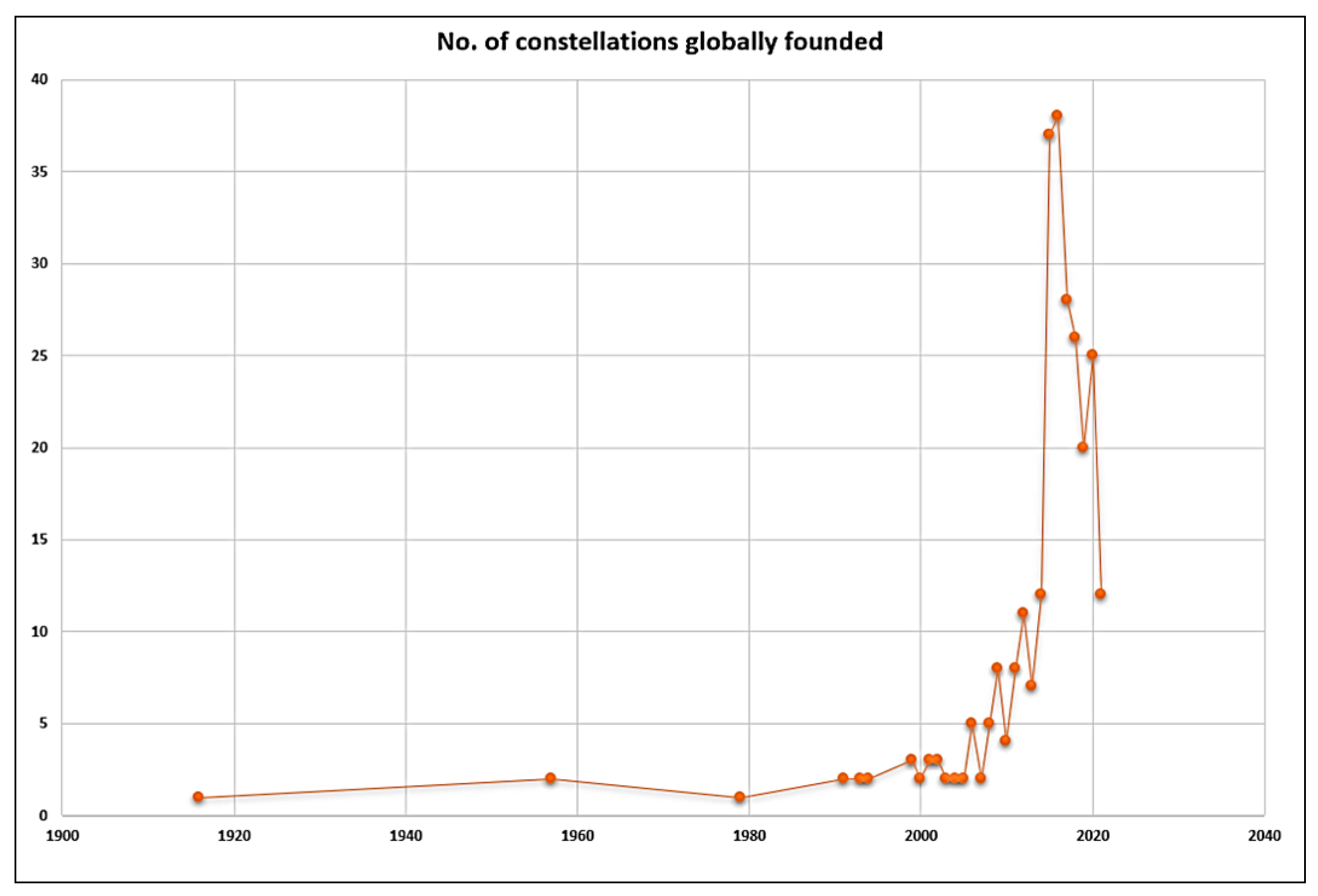
Some of the recent trends of these small-satellite constellations have been recorded by the NewSpace webpage and in a previous study given in Ref. [
1] and portrayed in
Figure 1. This earlier research considered various parameters and key records of these commercial satellite constellations, throughout the range of small satellites, including the cubesats. Another study was conducted by the NewSpace webpage representing the form factors of satellites in recent years, as depicted in
Figure 2a, which is supported by the data presented by Ref. [
2] for the number of satellites per constellation launched by major companies globally in recent years, as shown in
Figure 2b, respectively.
The above-mentioned references are quoted to highlight the evolution of small satellites in the NewSpace era. During the past decade, there has been significant demand for the competence to develop, test, and implement the small satellites in constellations to meet the necessity of global imagery, predominantly for applications in disaster management and to address key environmental issues. As a result, small satellites are urgently needed. In a single reference, an earlier study Ref. [
1] provided a clear overview of the direction promoted by the global space community for implementing the much-needed constellations, in terms of their status and various statistics. Another study Ref. [
2] presented a survey of the large constellations of small satellites, classifying the trends in recent years, not only in terms of the number of satellites, but also the satellite type. NewSpace (newspace.im) is a statistical webpage for highlights the current trends in constellations and satellites as a whole and is updated every few days to months.
1.1. Problem Definition
Globally, major concerns exist regarding the major real-time issues faced by the small-satellite constellations during a significant period of their operations.
The questions that govern these issues can be framed as below:
How can the relief under the disaster situations be managed with the constellations with fast data rates and optimal travel path?
Which optimization technique can significantly reduce the travel path burden for each satellite in a plane or formation in constellation?
How can we achieve autonomy in the NewSpace constellations to efficiently reduce the human intervention and efforts to maintain the best possible orbit every time it passes through a ground station until its lifecycle?
How can we determine the major role of these constellations (with optimizers) in aligning the Artemis and support operations for initial lunar missions and deep-space network?
This paper will provide insights on the optimization of the orbit travel period (range) by enhancing its orbital elements significantly by using predominant optimizing solutions. Mainly, the inclination and the semi-major axis of each orbit in constellation are of prime importance.
The constellations launched globally have their own set of issues and concerns to maintain the quality of the incoming data as well as to maintain their respective orbits without losing them to perturbations or decaying due to LEO environmental conditions. A strong control on all the satellites can be balanced out by orbit travel period so that the data can be received by respective strategically placed ground stations timely. A detailed study on the parameters, situations, orbits, and related work carried out on constellations has been observed extensively. There has been a significant research undergoing in this aspect of the constellations with majority of the constellation developers are making efforts to reduce the cost of the satellite development and operating them for the given lifecycle. Optimizing the number of satellites in a constellation is also a major concern among manufacturers. The importance of choosing the best solution for the orbit remains to be higher than any other operating measure in real-time scenarios. The shortest path of travel with a longest reception pass of a satellite is the need of the hour. The cost, objective, and coverage fracture contribute to the constellation’s best trajectories to be prepared and facilitate the end-users accordingly with the fastest receivable data.
The increasing demand in the disaster management applications from the satellites is quite overwhelming. The data being received in a full package is an absolute necessity and managing them without many anomalies is an engineering challenge. The constellations of small satellites can contribute effectively towards filling up this vacuum with creative methodologies, continuous research, and implementation of unique techniques. This research is dedicated to the purpose of finding efficient solutions to the problem of providing effective, usable, continuous data to the end-user. This can be achieved through the optimization and analysis of essential parameters and relating their importance on ground and in orbit through constellation of small-satellites with a unique configuration. Towards this direction, the following terminologies were framed, discussed, and implemented.
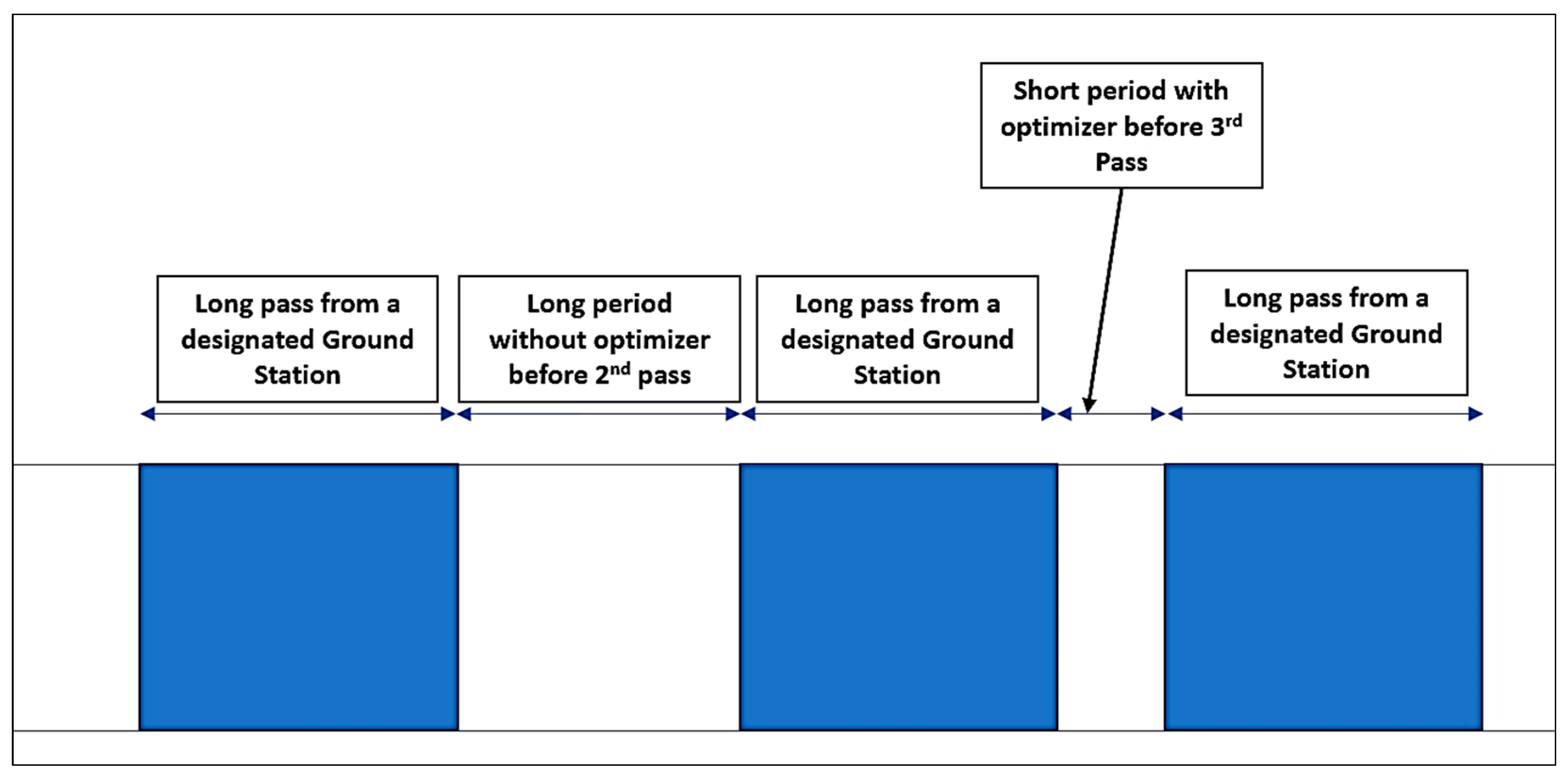
There are two terms used here, ‘Long pass’ and ‘Long Period’, as shown in
Figure 3. The long pass is the always desirable from any ground station point of view because the longer the pass of a satellite over a ground station, the better the reception window of the data and possibility of a full packet to be received. If the pass is for a shorter period of time (calling it short pass), it can influence the delivery quality of the data to the ground station and have poor packet reception (possibilities are more). The long period can be defined as the period of wait for the satellite to reach again to the same ground station without an optimizer used. If the optimizer is used, the long period is changed to shorter one and the wait time is reduced. Hence, it is important to reduce this time of waiting before each pass as it contributes towards faster data reception and early availability for the disaster relief situations.
1.2. Role of Autonomy
This paper introduced the concept of the autonomy to be used for the constellations for the problem defined in the
Section 1.1. It is crucial to know how the satellites choose the optimal solution for their orbit travel period autonomously under operation.
This research focused on implementing the autonomous behavior of the small satellite constellations using the optimization techniques to solve the major issues in Low-Earth Orbits respectively. Each satellite obtains enough strength and robust capabilities through autonomous optimizing of the trajectories in such a way that the operator intervention is minimized and the data transmission is significantly paced. Not only in the LEOs, the deep space missions can also utilize these enhanced capabilities from autonomous control for the smooth operations to communicate among the satellites and to optimize the orbits in order to precisely and quickly communicate with the astronauts on the ground (Support for Artemis missions). Hence, with this as a primary purpose, this research progressed and simulations were designed thoroughly.
1.3. Why Disaster Management?
As mentioned in the
Section 1.1, the disaster management remains to be the most crucial applications across the globe due to several factors such as global warming and ecological calamities. This section will provide detailed insight on present situation and what needs to be carried out to improvise it aligning with the problem definition given in
Section 1.1. The world needs stability with respect to the reliable systems for easy and effective transmission of data for significant applications to support life and sustainable resources on Earth extensively.
For this, the constellations are primarily essential to provide timely data to the locations which immediately need relief and tracking data of the worst affected areas. Several companies worldwide are planning and some have already implemented the small satellite constellations with commercially available data to the end users.
However, the major concern is that these products from companies currently are highly expensive and out of reach for majority of under developed and developing countries. Hence, there is a major necessity to make constellations from Commercial-off-the-Shelf (COTS) components effective enough to deliver the same level of data products as the traditional ones respectively.
The major advantage with COTS is that it provides the opportunity to develop smaller miniaturized components which is a great benefit in small satellites and can affect the performance in a constellation as well with greater reliability and sustenance for a long-term mission. Not only performance or reliability, COTS such as MEMS (part of COTS family), can help constellation operations through lower power consumption, robustness, enhanced assurance and most importantly saves cost of implementation and procurement. As the technology for constellation operations and maintenance evolve, the resource optimization, strong inter-satellite communication, and exchange will remain of absolute importance among the satellites to remain in their aligned orbits autonomously.
The COTS-based systems are cost-effective due to the fact that the value and the benefits they provide with a given cost are much higher than the traditional components. The purchase cost of COTS is substantially lower than the traditionally used ones due to lower cost of their development. They can also be purchased and operated at a lower expense over in-house development ensuring higher quality and durability.
Hence, overall this research aimed at providing the solutions (using COTS) for a cost-effective implementation of the constellations. Though this portion of COTS is not directly related to trajectory optimization, it is taken up due to their major importance in aligning robust and cost-effective small satellite constellations for a longer duration operation in near future which depends on the components which are used and their effective performance over stretched lifecycle.
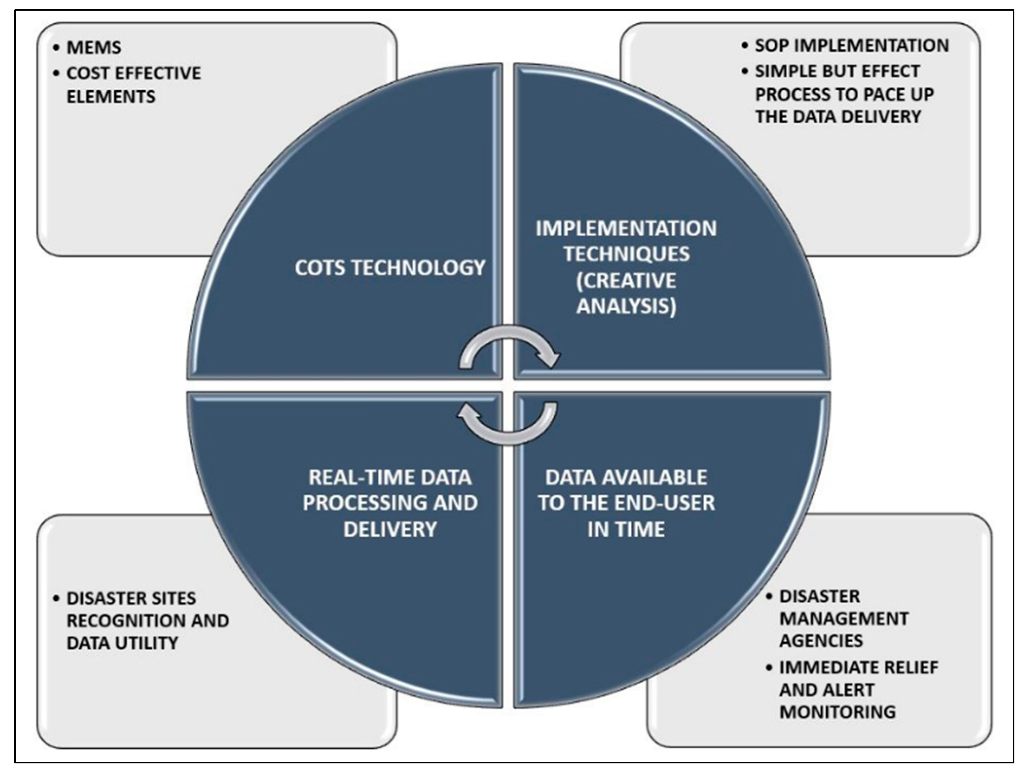
Figure 4 provides a visible description to the disaster management implementation processes which is core of this research.
This paper primarily is focused on providing an optimized trajectory solution for LEO using a unique optimizing technique for multiple ground stations or regions of interest. This implementation is planned for an autonomous behavior of the proposed optimization, propagation of the satellites in a well-formed constellation, and to address issues autonomously while in orbit.
1.4. Significance in Lunar Small-Satellite Missions (Artemis and Beyond)
In this research, the importance of implementing the major technologies executed in LEO to be utilized in Lunar missions was emphasized. The operations of Artemis are crucial for all of humanity as a whole. Hence, the smooth communication and operation of the mission is key for the successful lifetime operations of the same. The communications and operations support will remain extremely important for the astronauts and other systems to cooperate and be implemented effectively.
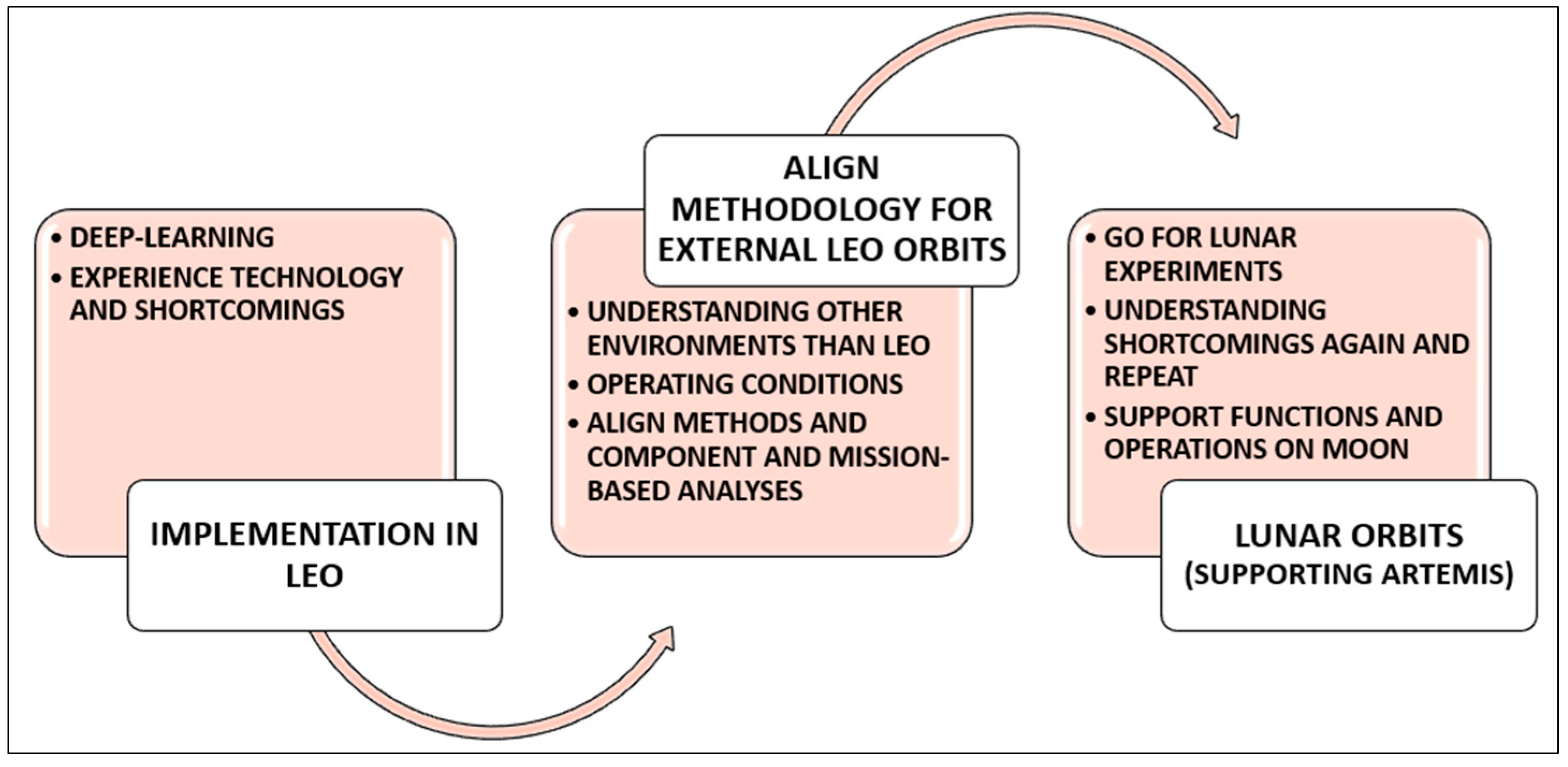
Figure 5 presents the process of establishing the lunar orbits utilizing the technologies utilized for LEO and supporting the Artemis mission for its operations.
In this process, the costs involved in the logistics, the planning to make small-satellites better utilized contributing to the main goal of the Artemis and beyond, and strategies of trajectory alignment for continuous payload/necessities transport will be crucial to be analyzed for optimal resource consumption and overall significance of the project.
Overall, this paper focused on providing insight on a severe environment scenario through a simulation which will be effective in ground communication and operations on lunar surface utilizing the lessons learnt in LEO significantly. A major portion of this paper was also published in Ref. [
3], which is only visible to its specific audience. The main goal of this work was to emphasize constellation operation using small satellite configurations under a severe space environment while still being able to optimize the coverage and pace up the data relay and delivery with the best possible solution. Some of the key benefits include fast data reception to the end users, quick relief provision at the affected areas of disaster, increased and well-aligned revisits to a particular location/ground station, autonomous in-orbit decision-making for the trajectory to be taken while maintaining their positions, and an optimized solution in a harsh LEO environment. Simultaneously, the Artemis mission can also be supported with these techniques to enhance the ground capabilities and the mission itself.
2. Constellation Dynamics (Walker)
The mathematical module plays a major role in aligning the right orbit and orientation of the satellites in a plane, as required by the mission. Hence, detailed research was carried out to ensure that each element is finely analyzed and implemented through simulations.
Small satellites have specific conditions and ways to operate due to their compact sizes, weight constraints, and restricted applications with given payloads. So, a well-defined system engineering approach needs to be adopted to orient satellites in such a way that they align to achieve optimal coverage and reach the desired locations in the shortest time possible in their particular plane.
Walker constellation is one such significant pattern which is used globally for various applications, but for this paper, a further delicate approach was made to expand the use of walker type constellation and maintain better optimality for a dedicated period of operation.
The major objective of this paper was to maintain and optimize the travel period of each orbit significantly to reach the end-user as quickly as possible while choosing the best solution through optimization technique. To do so, the walker dynamics had to be potentially robust for each satellite in every plane of the constellation. There has been certain research carried out to determine a reasonably optimal walker constellation for several real-time applications, but for disaster management the scope still remains open. There can be significant improvisation in maintaining and optimizing trajectories with an autonomous alignment approach to make the data delivery faster as needed.
Hence, detailed research was carried out to study the mathematical models which are most suited for this kind of application using autonomous technology and algorithms. This is not only to enhance the trajectories, but also to significantly reduce the number of satellites to be operated to achieve a particular coverage objective.
From the literature, it has been observed that a variety of modules have been used for understanding several scenarios of constellation operation through walker patterns. For this paper, a few of the most significant approaches were followed and implemented as suitable to the major objective (disaster management) for the optimization and maintenance of a global small satellite (using COTS) constellation understanding and undertaking all the constraints and situations in real-time conditions, respectively.
The main issue of coverage was addressed using the phenomena of nadir-pointing coverage circle area
presented by Ref. [
4] to be given as follows:
where
is the radius of Earth and
h is the altitude of the satellite.
The potential of the walker pattern can be properly utilized with its parameters aligning as required/suitable by their appropriate mathematical modeling considering the initial real-time conditions. The important integers mentioned as N (satellites), P (planes), and F (phasing parameter) define the relative movement of the satellites in a plane and autonomous control is also implemented to secure their movement with respect to the satellites in other planes. The specialty of the walker constellation is that the satellites remain uniformly distributed along the plane, giving enough opportunity to plan and implement the autonomous formation among them in a plane they are operating. Additionally, one interesting fact about this is that the only two parameters, which vary and have significant impacts on the constellation, have semi-major axes and inclination of the orbits with respect to the travel trajectory optimization. The right ascension of the ascending nodes (RAAN) also varies when aligning the orbits in different positions without interfering with one another. The correlation among the RAAN and the mean anomaly was also set using Ref. [
4] as follows:
where
=
/
represents the number of satellites per plane,
is the RAAN and the
represents the mean anomaly respectively.
The reference to the user position is also of importance when the coverage of the satellite is considered for the disaster relief management. According to Ref. [
4], there must be at least four satellites in sight at any time for determining a position of a potential user. The equation for the same is given by Ref. [
5] as:
where
is the user position error,
is the factor depending the relative position of the satellites, and
is the pseudo range error factor.
In fact, the reference mentions that the role of is so large that the larger its value, the lower the quality or coverage of the given constellation with respect to the location of the end-user.
Equation (3) and Refs. [
4,
5] are quoted to understand the concept and importance of end user position error. This also determines and implies that the case of a global augmentation constellation with a single objective function is considered as having a global average of four visible satellites at each time of the pass over a ground station or an end-user location.
Due consideration of this concept was given while formulating the design constraints and the configuration of this paper by first selecting the areas of interests and aligning the ground stations across them. Then, the constellation design was prepared to suit the orientation of the ground stations with a 45-degree inclination of each orbit to cover the areas as mentioned in the following sections. The optimization of these trajectories to find the best travel path is necessary to obtain the shortest path for satellites to travel and deliver the data in the quickest way possible. However, the end-user position error analysis is not included in this paper as the focus remained on the optimization and factors mentioned in the abstract. In the near future, a detailed study on the visibility and end-user positioning and error analyses is planned with a similar configuration.
There is also a need for establishing the ground stations in sync with satellites deployed to receive the data and track the satellites in operation. For the same, the repeating ground track (RGT) was selected as continuous revisits are essential for LEO-based constellations. The Ref. [
6] show a detailed overview of the dynamics involved in ground tracking and following it, the required equations were determined as below:
where
is the ratio of number of revolutions (
) and the number of nodal periods (
).
A very interesting fact noticed here with regard to the walker constellations is that under certain ground conditions, the Common Ground Tracking (CGT) utilizing the circular Repeat Ground Track (RGT) orbits is expressed as follows:
where
is 1 and follows the same notation as the walker constellation as represented in Equation (2), respectively. That means the CGT constellation with RGT orbits is a common scenario used extensively by the constellation operators globally.
Moreover, the access profile condition was also determined using Ref. [
6], which provides the actual relation between the relative position vectors from the ground to the satellite as follows:
where
is the satellite position vector from Earth’s center and
is the target point position vector from the Earth’s center.
The elevation angle for the same is given as follows:
On the other side, Ref. [
7] elaborated the target to satellite angular relations and emphasized maintaining thorough pattern designs using the same.
The references suggest that the instance angle will be an addition of the elevation angle and 90 degrees exactly and can be expressed as below:
where
is the instance angle and
is the elevation angle.
The inclination is fixed; hence, even for walker constellation, the angles and their orientation play a vital role in aligning the satellites specific to certain boundary conditions. A special Napier’s rule was used for right spherical triangles as below:
Similarly, a satellite’s longitude is determined as:
Similarly, a similar equation in the celestial sphere is given as:
The angles operating between the satellites in a walker pattern constellation also constitute a dynamic approach to build it in such a way that a robust formation in each plane can be observed, as well sighted in Ref. [
7], and is thoroughly followed for the simulations.
The angles among the planes and satellites are defined as follows:
, and are the radial spacing plane to plane in celestial sphere, angle between satellites in same plane, and angular offset between satellites from one plane to another.
The respective formulation then framed is given as follows:
where
,
and
represent the same as mentioned before (no. of planes, relative spacing, no. of satellites).
Finally, the RAAN spacing for each plane was also set as below:
where
is the true anomaly and
is the number of orbits over a single rotation of Earth.
3. Constellation Set-Up (LEO)
Based on the reasoning and dynamics mentioned in the chapters above, walker constellations with unique orientations are a way forward and respective simulations were planned and executed. It is not about the number of satellites that align through the constellation planes, but how optimally these satellites can perform with a minimum of resources utilized in orbit for a longer period of time. Hence, the utilization of Commercial-off-the-shelf (COTS) components becomes an essential vision of this proposed research. This needs to be supported with innovative trajectory optimization techniques for better coverage, understanding of on-orbit conditions and requirements for fulfilling them for maintaining cost-effective global constellations for their given lifecycles, respectively.
The initial constellation set-up (pre-optimization) planned for this paper is given in
Table 1 below:
In a real-time scenario of the constellation meant for imagery and data transfer for disaster management applications, the number of satellites deployed would be less and are launched as per the needs of coverage and number of end-users and their locations. This set-up was made to analyze a bigger picture of a constellation performing a global operation with multiple end-users worldwide. This will result in investigating the situations and conditions of operating larger constellations of small satellites over a significantly long-term period.
The main reason for selecting the scenario given in
Table 1 is to test the constellation operation at a Low-Earth Orbit (with a semi-major axis of 7000 km) where the influence of the atmospheric drag (specifically J2) is quite severe and the solar radiation pressure/winds are also heavily active in the region. The idea is to test the constellation under these severe conditions and analyze the coverage optimization for the best possible solution. If the constellation could survive this initial condition and operation to give solutions, then similar or higher altitudes could be highly productive for future missions.
Adding to this, a walker constellation with 45-degree inclination is the first of a kind to be tested under these given situations and initial conditions, respectively. Additionally, with the ISS being at 408 km for conducting various Earth-benefitting experiments, the Low-Earth altitudes are of prime importance for disaster-management applications.
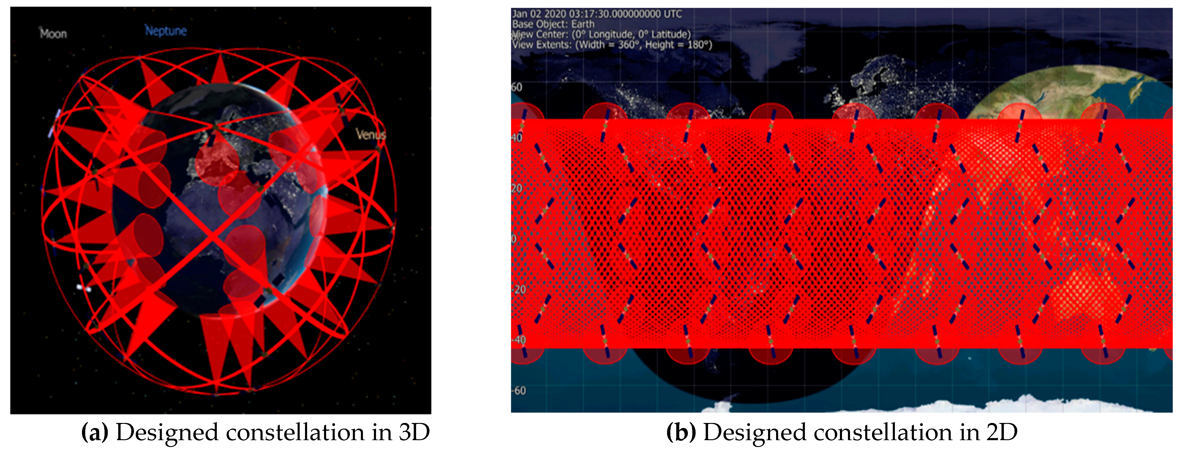
The set-up is pictorially depicted in
Figure 6 as below:
4. Effect of Perturbations
Perturbations usually have major impacts on satellites but they affect the functioning of the constellations as well. Recently, as per the Starlink constellation operations team, more than 40 satellites were declared to be lost due to the effect of solar winds/storms and other perturbations as presented in Refs. [
8,
9]. This is a typical scenario for any satellite in LEO/MEO, but the impact on a constellation with small satellites would be much larger than expected and sometimes fatal to all the satellites aligning each other in a plane or in offset to other planes, respectively. Hence, an analysis was separately planned to address this issue and make sure that the impact is studied well and analyzed for building robust constellations using small satellites for the near future.
Solar radiation pressure and the atmospheric drag are defined by the formulas as mentioned below:
After an extensive study of the Ref. [
10], the following equations for Solar Radiation Pressure (SRP) and Atmospheric Drag were obtained with due consideration of the proposed configuration of constellation specially with small satellites as given below:
Solar Radiation Pressure (SRP):
where,
is acceleration due to SRP.
= Mean flux at one astronomical unit (AU) given as 1400 W/m2
= Coefficient of Reflectivity of the satellite
= SRP area
= mass of the satellite
= Speed of light
= Astronomical Unit (generally defined to be distance from Earth to Sun) and numerically is calculated as 149,597,871 Kms.
= Essential unit vector from Satellite to Sun
= Eclipse factor (0, if the satellite is in shadow; 1 if in sun light)
Atmospheric Drag:
where,
is the coefficient of drag,
is the drag area,
is the density at the spacecraft’s current location, and
is the magnitude of satellite velocity relative to the rotating atmosphere.
is the spacecraft’s velocity vector in the reference frame;
is the Earth’s spin axis vector in the reference frame;
is the spacecraft’s position vector in the reference frame;
is the unit vector in the direction.
A distinct simulation was carried out to find the possible scenario and changes to the satellite position/altitude with the altering environment surrounding it.
Under the influence of atmospheric drag and solar radiation pressure, the variation of height over 90 days is shown in
Figure 7 below:
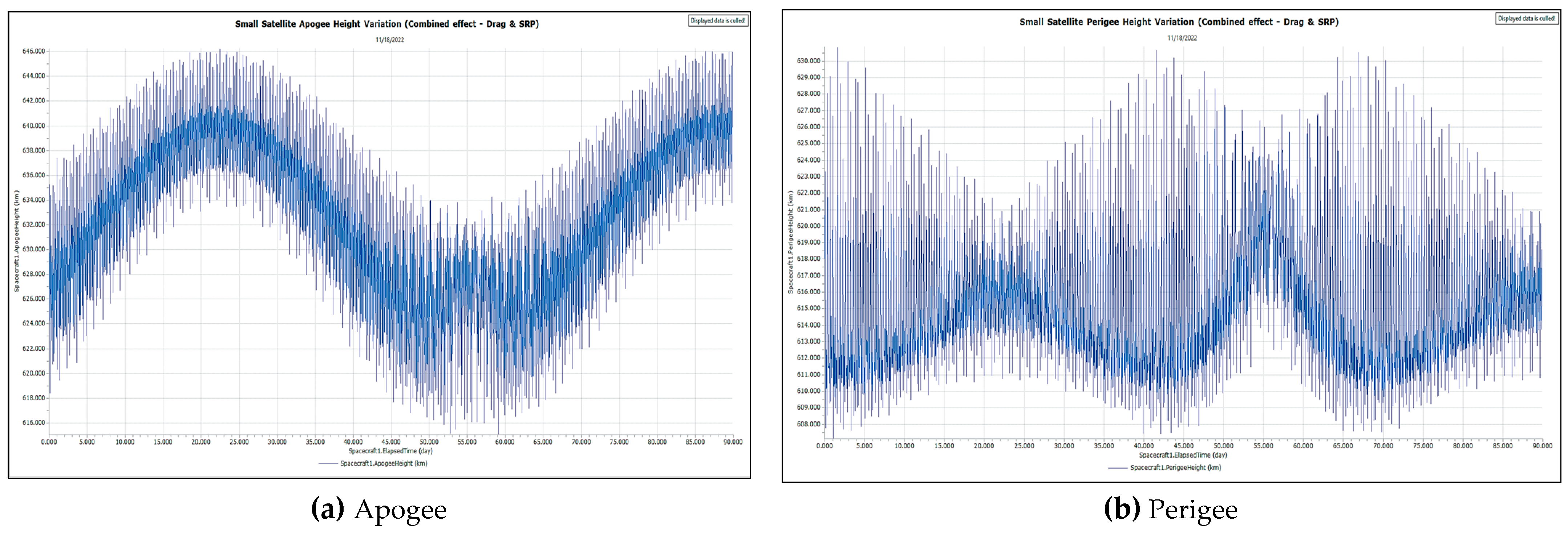
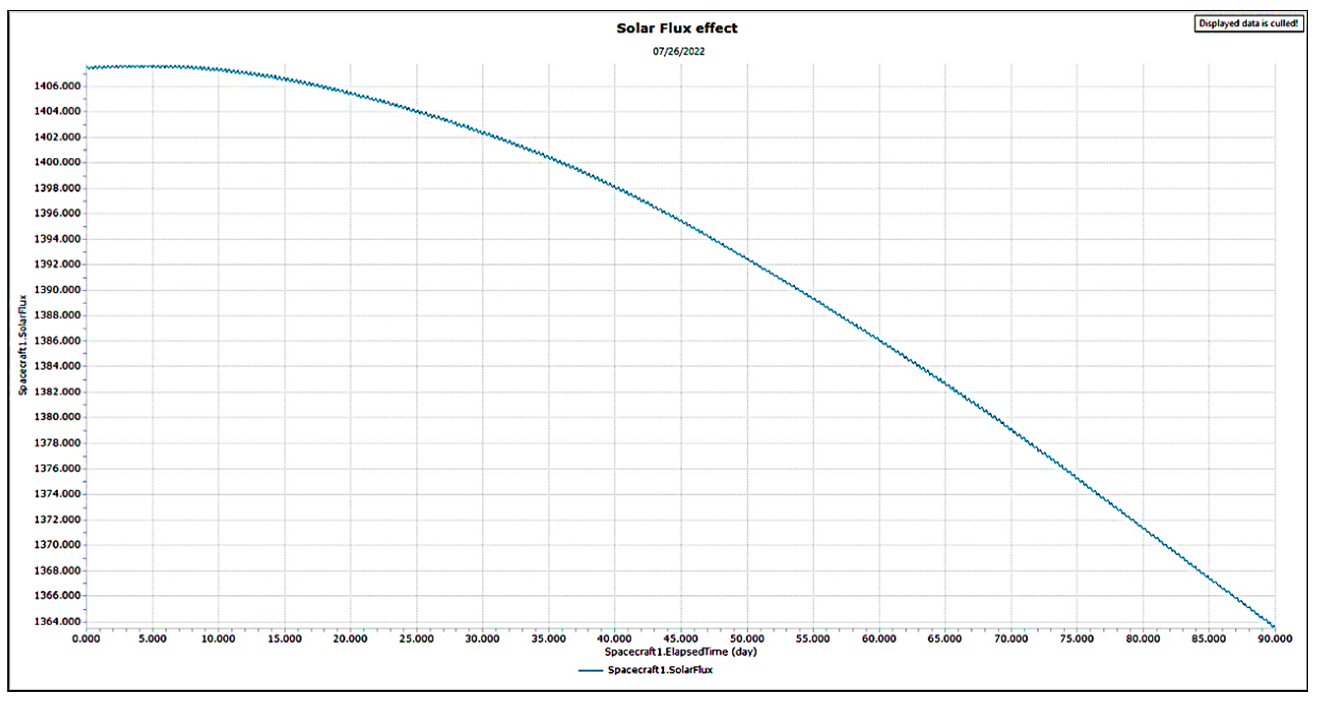
Now, instead of height, apogee and perigee heights along with solar flux were calculated to observe the environmental variations and subjected to propagation for 90 days as shown in
Figure 8 and
Figure 9.
Hence, it is of the utmost importance to consider the environmental effects on the trajectory that the satellites in a constellation take and perform their functions. The following questions have always been imperative to small satellite constellation research:
- ➢
How does the harsh space environment with growing space debris impact operating small satellite constellations?
- ➢
How can a certain pattern for a constellation which is effective for a long period for disaster management application be operated?
- ➢
How should decisions be made effectively for the end user to efficiently utilize data with the given coverage of a constellation?
- ➢
How can creative methodologies can solve in-orbit problems with small satellites specifically considering their compact sizes and resource constraints?
Some research, such as Refs. [
11,
12,
13] has contributed towards solving similar problems significantly and this research is an extension of the same vision insofar as it presents the impact of the trajectory enhancement of small satellites in a constellation.
5. Ground Stations and Region of Interest
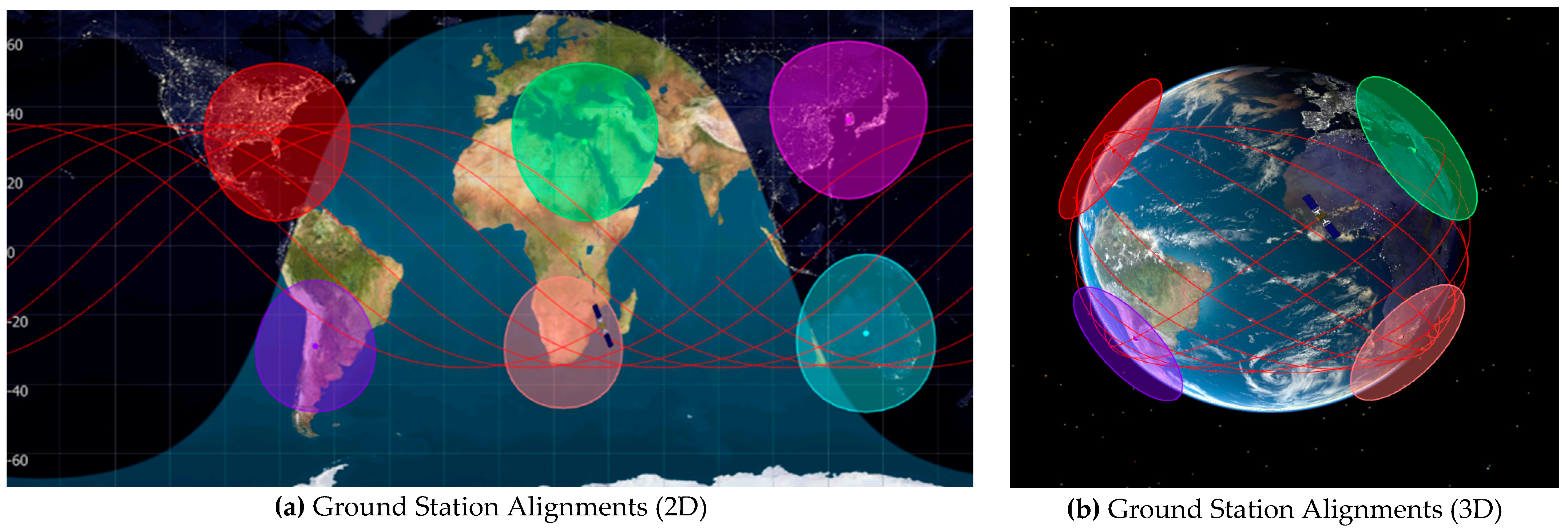
The ground stations remain as the major portion of the constellation and operations. The provision to determine the right location for receiving the aligned data is absolutely crucial for a small satellite constellation scenario. For a global constellation, the ground stations have to be strategically be placed to support satellite data reception effectively. Hence, thorough research was carried out to understand the basic operation of ground stations under a global constellation with small satellite parameters and the necessary propagation conditions.
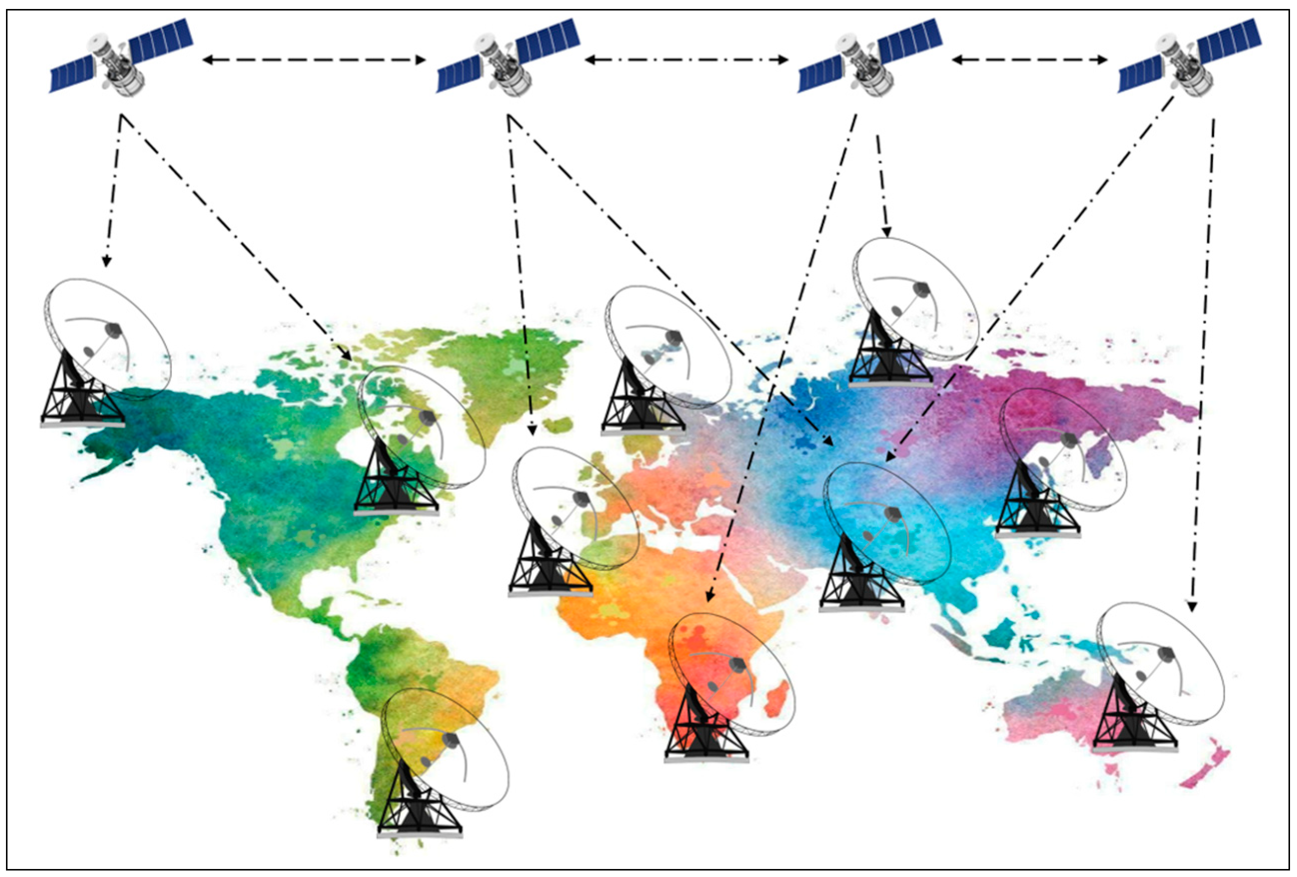
Achieving autonomous ground station operations were one of the primary objectives of this research but are included briefly to show how best the satellites can coordinate with the ground stations to deliver the information/data to the next available ground station. For this, an autonomous methodology is being planned and will be published at a later stage of the project. This paper mainly emphasized the calculated positioning/placement and alignment of these ground stations specifically focusing on the best coverage function scenario for a global constellation. An optimal and strategic approach for the network of ground station positioning would yield cost-effective implementation, saving the unnecessary cost of an extensive number of ground stations and operations. An autonomous system would definitely help in attaining the full coverage with minimum satellites and ground stations with due consideration to all the small satellite constraints and their real-time capabilities. A glimpse of the orientation of the ground station with respect to the constellation in operation is shown in
Figure 10 below:
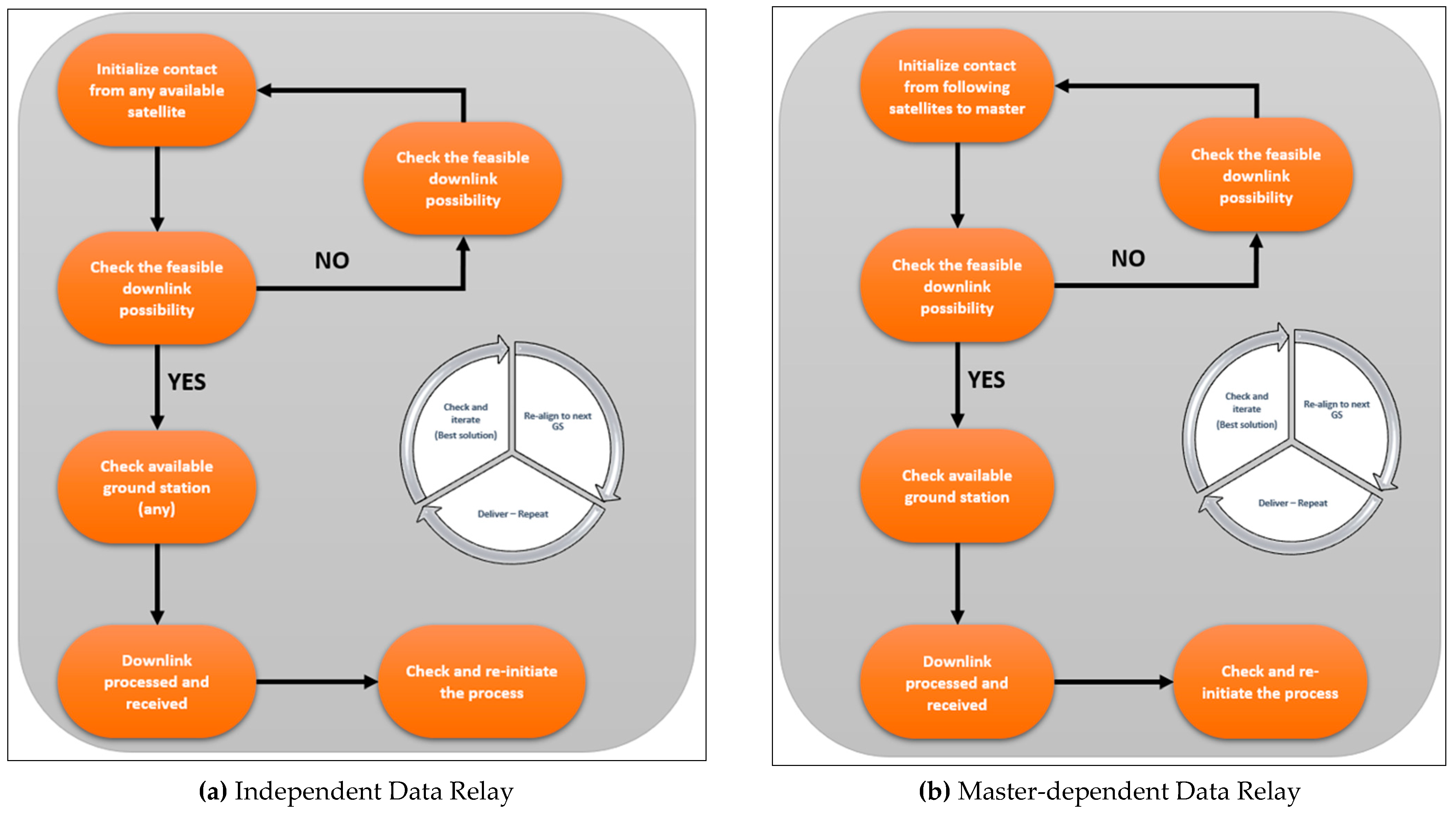
The communication is planned to include:
- ➢
The ground station to the master satellite (with the following satellites communicating and transferring data along the same plane).
- ➢
Individual communication of all the satellites to all the available ground stations (other planes included).
These two techniques are depicted as process flow charts in
Figure 11. The sequence of the operation is subject to autonomous self-orientation of the satellites with the available ground operation, respectively. This totally depends on the configuration of the designed constellation and the capacity of the satellites to be self-organizing for easy communication and in-orbit problem solving. The essential point is that irrespective of the data relay process, the long pass at each site is to be retained.
It has been observed globally that the systems that can define autonomous ground station operations can make a significant difference to seamless data reception with minimum errors and saved time. The long-term reliability of these features and operations remain to be proven, but the scope of research is widely available. This research paved the way for such important features to be included for small satellite constellations, thoroughly solving the majority of data-management issues and support disaster management applications.
Hence, considering the above-mentioned possibilities, the ground station-based simulation was made and analyzed thoroughly. Though autonomous behavior is not presented in this paper in detail, a brief idea was shared. The simulation was performed taking one satellite into consideration from the constellation for demonstrating the ground station communication and parametric behavior in real-time situations. This will be replicated to all other satellites in the constellation and relay the data to the respective ground stations using either independent or master-dependent techniques as designed.
The six ground stations were located, representing each area of interest as shown in
Figure 12 below:
Figure 13a provides a propagation of elevation angles from all the ground stations for a satellite for a period of one day. It signifies its role in making the data received appropriately with minimum deviation. Elevation angles remain as a judgmental parameter to address the health of the data received or any anomalies in the process.
Figure 13b provides the inclination of a satellite in a constellation, which plays a vital role with respect to the elevation angle of a ground station to achieve the full pass for a complete packet delivery. Small satellites were improvised on this side of the research, but a substantial scope still remains for constellations to maintain their orbital elements in line with elevation angles thoroughly. As shown above, the variation of the orbit inclination with respect to the elevation angle remains under 1 degree.
Figure 13c simulates the satellite’s position, which also affects the elevation angle of the ground station due to perturbations and other influences over the period of propagation. A thorough consideration to these factors is noted while studying the real-time implementation of the ground stations for other projects. Hence, it becomes a necessity for the constellation-based analyses to include the ground station parameters and study them extensively for overcoming the majority of the communication-affecting factors and accessing data in a fast and simple manner. This also shows that the variation of satellite position along the 7000 km semi-major axis has a greater impact on the visibility to the aligned ground stations. Except few peaks, the satellite shows great stability even with its compact size and other constraints.
Figure 13d shows the altitude variation and also accounts for the effect on the communication with the ground stations. The elevation angles may vary and have lower visibility as the height of the satellite is altered due to perturbations and other unknown factors. The altitude variation remains under 10~12 km, which is reasonable, as a satellite in a constellation should vary under the given operating conditions.
Overall, in view of the description given for the scenarios and analysis presented through the figures below, it is observed to keep a continual track of the small satellites. This is for the effective understanding of the operations on orbit and on ground together in a synchronization which will ease the separate and discrete tracking required for the constellation operators for each satellite. Though it is managed autonomously and reported daily, the unknown anomalies and data-less data packet scenarios can be sighted and reported for the researchers to analyze them for avoiding any chances of operation halting at any given instances. More such information is under analyses to make the constellation of size in this paper (48 satellites/8 planes) can be managed and sequenced autonomously seamlessly for simple but effective operation for the period of its designed lifecycle.
The simulation results for the same were obtained as below:
6. Optimization Technique (ipopt)
The optimization of the trajectories constituted a core purpose of this paper and a major portion of this research. Self-organizing satellites (autonomous) are proposed to be self-optimizing in-orbit as well to make sure the travel path is selected adequately and as quickly as possible for the real-time application of disaster management globally.
There are several optimizing techniques implemented for individual satellites and in constellations in recent times [
14,
15]. However, the purpose of the constellation optimization in this paper was to confront the perturbations and abnormalities in severe space environment and several unknown objects (Debris) and smoothen the trajectories under extremely non-linear conditions to perform and analyze real-time scenarios.
For this research, several scenarios and possibilities were considered, and a non-linear optimizer was proposed to analyze its effectiveness for small satellite constellation operating in a Low-Earth Orbit. The Interior Point Optimizer (ipopt) is an optimization technique used for various purposes in the past and has served optimization needs over years. However, for this particular constellation scenario, this optimizer is being tested and aligned to the major parameters of the orbital dynamics to precisely know the best objective and coverage function possible for the given set-up in
Section 3 of this paper.
With regard to the orbit elements, the semi-major axis and inclination (as discussed earlier) remain as major orbital parameters to define the objection function and deliver the best solution for a full coverage scenario through a coverage function defined. This provides the fastest travel period possible to reach the nearest ground station with the longest pass feasible, resulting in the most optimal solution for a satellite or a plane to change its elements autonomously and deliver data at the quickest possible rate.
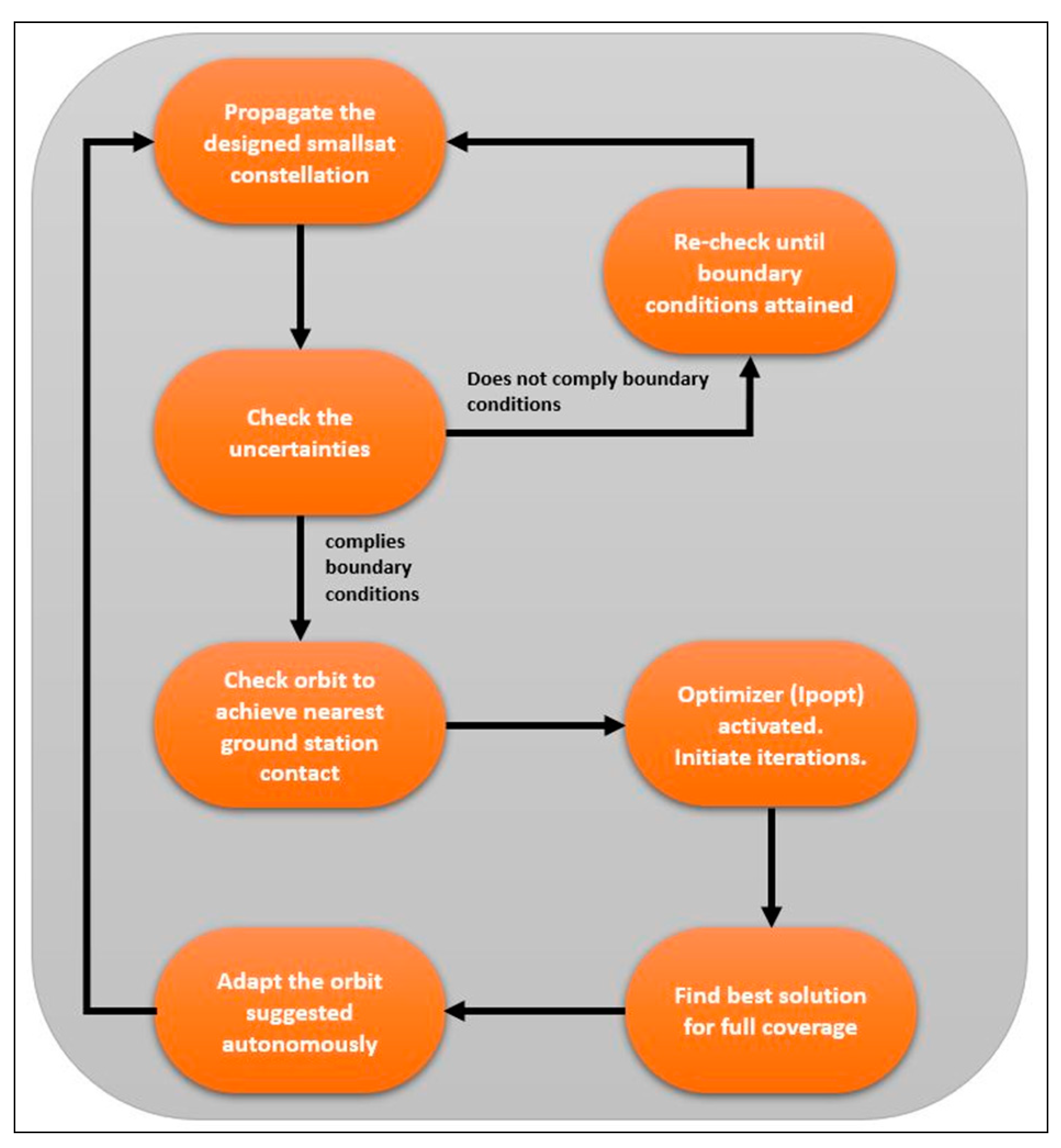
The configuration proposed is shown pictorially in the flow diagram as presented by
Figure 14 and was researched and analyzed for its importance to orbit. Given the constraints associated with small satellites, there is an absolute necessity to align autonomy with a significant approach and well-defined technique. The continuous propagation checks and its related anomalies were given a priority, and it is important to make sure that the orbital parameters are being maintained as designed for their particular position in the proposed constellation. After this, utilizing the techniques mentioned in
Section 5, the nearest available ground stations were tracked and data in a ‘long and full pass’ was delivered with an optimized orbit and this was made continuous until the end of the lifecycle of the given constellation. This achieved paced and seamless data tracking from each ground station.
A thorough study was executed to understand and implement this optimizer effectively in all portions of constellation and its planes. The Interior Point Optimizer (ipopt) is a software suite for large-scale nonlinear that finds best solutions locally which may or may not be the global optimal solutions. The form of this optimizer can be simply given as:
where
are the optimization variables with lower and upper bounds of negative and positive infinities with
,
are the objective and general nonlinear constraints respectively. Similarly, the
and
were used as nonlinear and non-convex in nature for this problem of constellation optimization. The
also has the lower and upper bounds to negative and positive infinity as well with
and the equality constraint of the form
by making arrangement with
, respectively. Apart from this, the in-depth mathematical modeling was studied and documented using several important articles including Refs. [
16,
17]. The
Figure 15 below provides a sense of important elements involved in the optimization process.
7. Optimization Results (LEO)
This ipopt optimizer was integrated with the small satellite constellation shown in the
Section 3 with similar configuration and the optimization was carried out for a thorough coverage analyses as detailed pictorially below:
For this analysis, the master region of interest was set to a Korean peninsula operating other region of interests and their respective ground stations from this base. The set-up was same with 48 small satellites operating in eight different planes, respectively.
Inclination:
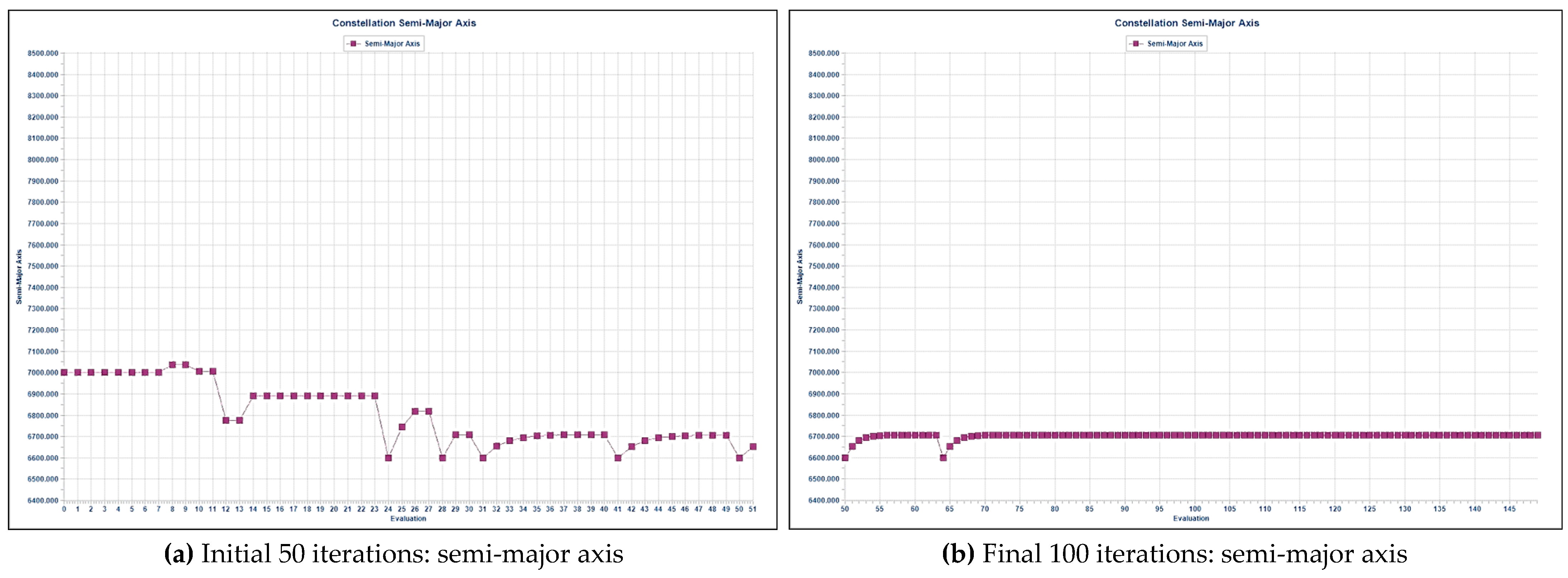
As mentioned earlier, the inclination of each plane is crucial to arrive at the nearest ground station optimally in a lesser time period. After running the simulation for optimizing the constellation, the following iterations for inclination and semi-major axis were obtained as shown in
Figure 16 and
Figure 17 below:
In the figures above, the variations started with initial iterations adjusting to the best inclination possible for the constellation for a better coverage, which stabilized well in the later iterations, significantly reaching the most optimal solution as shown in the concluding iterations. The inclination still held itself for later iterations with few dips to the lower inclinations but stabilized back to the optimal mode, giving best solution possible for each plane. The semi-major axis along with inclination plays a vital role in establishing an optimal solution to the propagation of an entire constellation of small satellites. The semi-major axes of the orbital planes take their points to stabilize the first 50 iterations and yield enough feasibility analyses for determining the best solution of optimal travel for a total coverage in the given constellation scenario.
This leads to analyzing the final solution with the best optimal iterations for coverage fraction, cost, and objective functions as depicted in
Figure 18 below:
The pictorial representation of a process in obtaining an optimal solution for the constellations given in
Figure 19 reinstates the fact that this portion of research contributes significantly to the design and orientation of the constellations using small satellites for a long-term operation in LEO region. The ipopt optimizer passed through this evaluation thoroughly as intended.
After all the iterations the optimizer performed, the best solutions with the proposed objective function, coverage fraction, and cost function were obtained as shown in
Table 2 below:
After the best feasible solution numerically was obtained as given above, the orbital trajectories with the master region of interest (Korea) were attained. This was pictorially shown with a fully optimized coverage with the given constellation along best the travel paths taken by satellites in
Figure 20 below.
An extensive analysis was carried out to make a better understanding with feasibility and associated parameters to it. The impact that the optimal parameters and trajectories have will add tremendously to the overall operation of the constellation in a harsh and tightly managed environment for the proposed configuration. Over a period of time, the operators of the constellations may actually reap the benefits from this optimization in terms of faster data, cost reduction and so on.
These considerations and obtained results will turn out to be game-changer to implement the cost-effective LEO constellations of small satellites if utilized strategically. The timely distribution of the data to the end-user with reduced cost and enhanced performance for a long duration of time along with effectively reduced revisit intervals adds significantly a lot to the disaster management applications.
8. Lunar Missions—Support to Artemis
As mentioned in
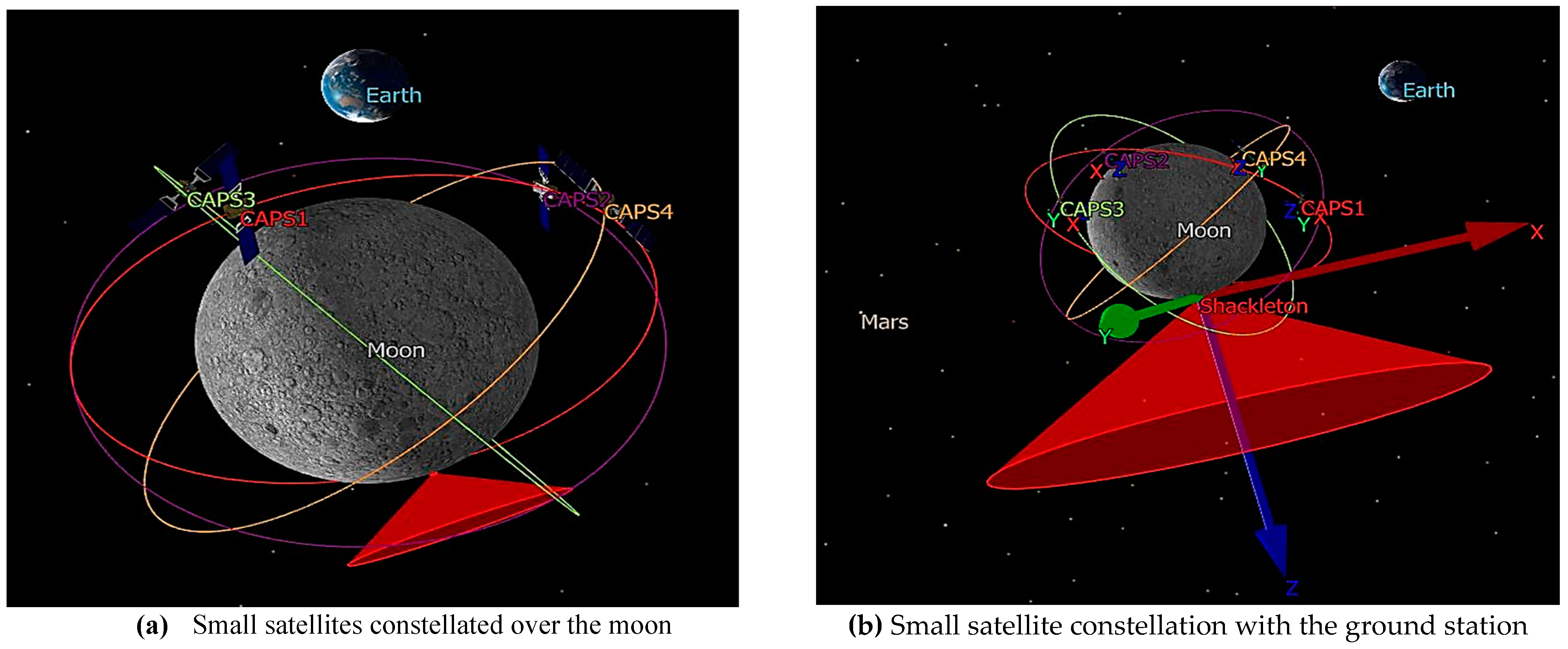
Section 1.4, this research not only aimed to solve problems on earth but also support ambitious deep-space missions such as Artemis. As Artemis-I takes a significant leap towards its launch and operations activities, a huge scope for the operations support is needed in the near future. Small satellites play a major role in aligning those operations thoroughly and support astronauts in Artemis-2 mission as well. This paper briefly demonstrated a simple constellation of small satellites communicating with a major ground station base named ‘Shackleton’ and managing important events at the lunar surface, respectively. Several such missions will take place in the near future to support and test the technologies in lunar environment. This research also aimed at significantly contributing to Artemis as a stepping stone to other major missions in deep space at a later stage. The simulations were planned and executed to communicate these small satellites (four satellites in a walker-like pattern) constellated over a lunar environment with the ground station (Shackleton) having a 10-degree elevation angle with well-defined parameters as portrayed in
Figure 21.
This research directed towards bringing about the major communication and tracking issues that this mission would go through while executing its required functions and operations. Working with an elevation angle of 10 degrees at the south pole of the Moon may raise several concerns with tracking the astronauts and effectively relaying the data.
The consideration to Equation (3) in
Section 2 is duly given for the design constraint in the lunar constellation case as well. However, as the operating satellites are only four in different planes, if they satisfy the 10-degree elevation angle requirement of the ground station, it is enough to communicate with the Shackleton ground station and in future using the optimization, best solutions for the orbit’s cost, coverage, and objective function can be obtained with an added number of satellites if needed for lunar operations.
This remains as an important future work to be carried out once the Artemis mission takes the operating position and provides a better understanding of the requirements for ground communication and operations. After the modeling of the given scenario of the lunar constellation and communication set-up, it is crucial to perform analyses on how the parameters interact with and make possible impacts on the overall communication and support operations. Hence, a detailed analysis was carried out and the following results were observed as below:
The simulations were based on the assumptions of the lunar environment and small satellite mass of about 85 kg and related configuration parameters were set accordingly. The need for these satellites operating in lunar ambience is a pivotal element of the NewSpace era.
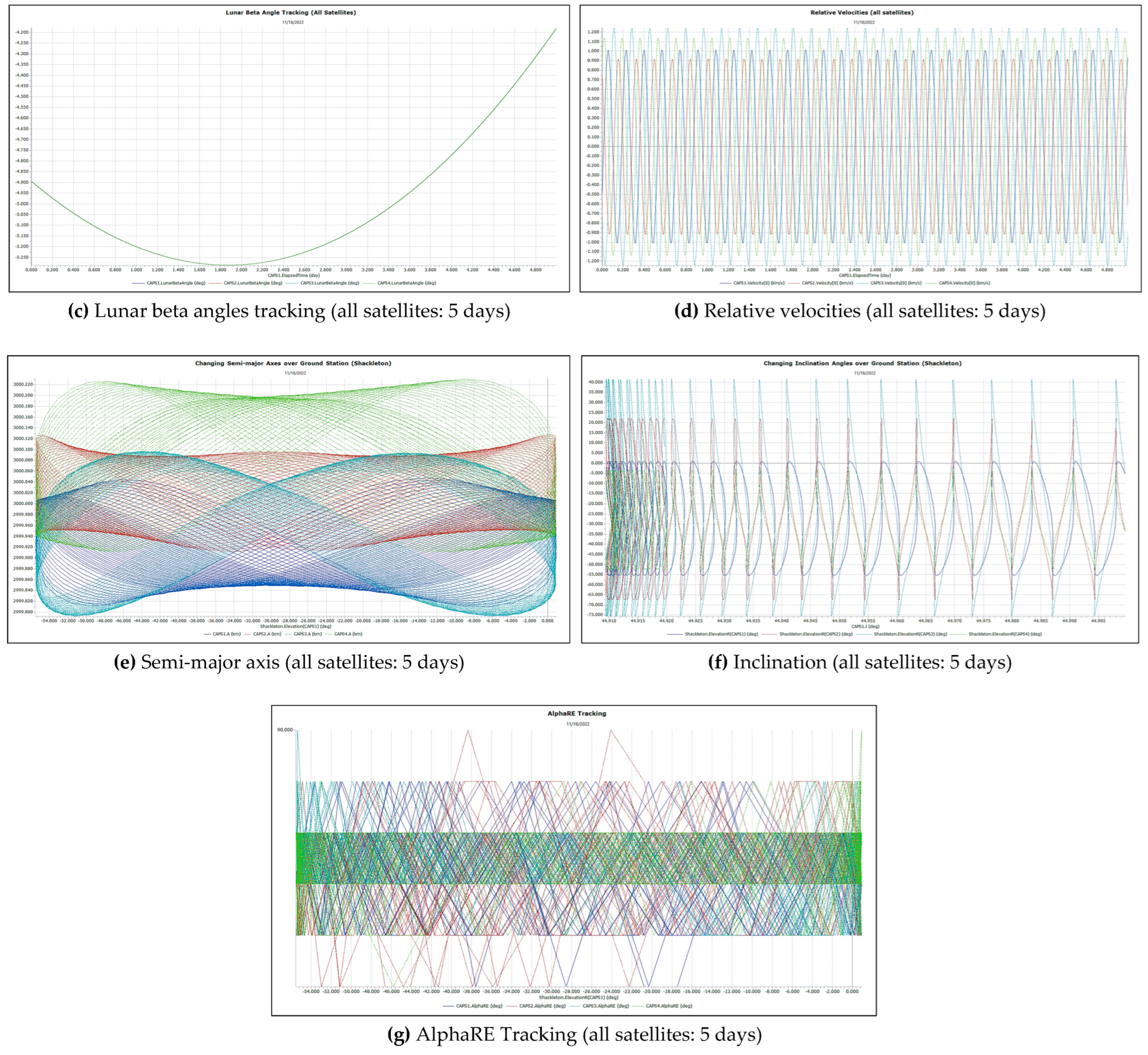
Figure 22a show the variation of apogee height of all the satellites with the elapsed time of master satellite (CAPS1) as one of the important parameters to keep tracking health of these satellites and know their farthest point to the moon at all times. It was observed that the satellites remained stable under the given lunar perturbations and local conditions as shown below but this monitoring has to be continuous and be observed until their lifecycles expire. These observations were made for 5 days of propagation.
Tracking the position of the satellites with due consideration to the elevation angle from the ground station is a major scenario to observe. As Shackleton is located at the South Pole, the tracking of the operations and the astronaut positions will be a heavy-duty responsibility of the small satellites. They need to coordinate with ground systems at Shackleton to let it know their position and be available at its designed elevation angle and tracking capabilities. Hence,
Figure 22b provides a detailed outlook of how the tracking and positioning of each satellite being monitored with the Shackleton ground station.
When considering a two-body problem with an Earth and moon system, the lunar beta angle plays a vital role in knowing the satellite’s operating track and monitoring it in the long run. The beta-Earth angle is the angle among the Earth–moon vector and the lunar orbit plane in which satellites are installed to operate.
Figure 22c provides a significant idea about how the lunar beta angles would vary with respect to the elapsed time of the given master satellite (CAPS1) at the Shackleton ground station. All the satellites showed the same behavior over time and remained consistent with their beta angles, which is a great sign considering a harsh lunar environment and stable tracking.
The velocities are essential track in order to know their behavior in the lunar environment irrespective of their other operating parameters. The reason for this is that changes in velocities (Delta-V factor) provides crucial information on the health of the satellites in their orbits and define the need for control and maneuvers in a timely manner for continuous operation and ground support. Hence,
Figure 22d outlines a monitoring scenario of all satellites in constellation over 5 days. The variation in this scenario remained under 2 km/s for a full orbit movement, ensuring stability in their operating environment.
As mentioned in
Section 6, the semi-major axis and inclination of the orbits are prominent orbital parameters to align an optimal trajectory for each plane in a constellation, as lunar missions supporting Artemis also need regular optimizations to keep up quick access of the satellite information to the systems and astronauts on lunar surface. Though this paper did not cover the optimizations of the orbits, an observation of both its parameters was given to analyze their behavior under severe lunar conditions as portrayed.
Figure 22e,f shows the variation of the semi-major axis and Inclination with the elevation angle form the ground station at Shackleton of each satellite (CAPS1~4).
Finally, the AlphaRE angle was used to give additional support to the attitude and control of the satellites and their tracking being analyzed for this scenario. This is the angle between the satellite’s Y-axis and projection of satellite-earth vector on satellite’s Y–Z plane as shown in
Figure 22g, respectively. As shown, the AphaRE remained under 90 degrees, which provides a good sign of the satellite’s healthy operation within its given orbit. This will be continuously monitored and upgraded over time of its lifecycle.
A consistent research on the literature work is carried out to be aware of how others are aligning their thoughts with respect to Artemis operations and other lunar missions as well. Prominent works performed so far by the global space community are creating a further scope for real-time analysis and related research in this direction, respectively [
18,
19,
20].
Overall, the figures below were obtained to give an insight on the essence of tracking major parameters under such harsh lunar environment. Small satellites have given crucial hope for supporting the operations of Artemis not only to fulfill the need for communication and ground tracking, but forming one of the essential support systems to the mission itself. This will add significantly to the process of implementing this mission from logistics from LEO to the moon, the operation on the ground, and on lunar orbit with continuous and enhanced communication capabilities. Not only for the communications and tracking, small satellites will be an asset for deep-space data relay from the moon to Earth and bring back information/samples to the scientists for breakthrough research for the understanding of the moon and beyond. This in fact adds to the value of Artemis mission.
9. Conclusions
This research was directed towards making an impact on the utilization of the cost-effective solutions to build small satellite constellations mainly for disaster management applications globally. Small satellites utilizing COTS have great reach in terms of resource and cost effectiveness, along with MEMS as a primary technology for sub-system level development for real-time execution in a constellation. However, planning the operations and designing an autonomous constellation is a distinct challenge when involving small satellites under 500 kg with a global coverage and less resources and reachability, which represent the need of the hour.
This paper mainly emphasized the coverage analysis and optimization of the orbits in a small satellite constellation to obtain the best feasible solutions in terms of travel time and fastest data transmission to the respective ground stations. This was achieved by altering the orbital elements most suitable to reach a particular location. The interior point (ipopt) optimizer was used with the proposed constellation set-up to analyze the best optimal solutions in Low-Earth Orbits autonomously. The simulation performed iterations as per the given initial mission design parameters, determined the feasibility of the solution, and then the best solution itself as per the given scenario. This optimizer (ipopt) has been used for several non-linear solutions for various other applications in the past. However, what is unique here is that on a non-linear large-scale such as a constellation with small satellites having limited resources and higher constraints on-board, the optimization of coverage has to be continuous and impactful in an autonomous and harsh environmental condition. ipopt provides solutions firmly for the continuous optimization problem in a non-linear state, which is suited predominantly for the LEO region under the influence of atmospheric and solar radiation-based issues. Though this work is mainly directed towards the disaster management and deep space strategy with Artemis, Refs. [
21,
22,
23,
24] gave enough motivation to propel towards a contributing research.
The uniqueness/novelty this paper brings about is to highlight the fact that the coverage analysis is not merely about having a global satellite reach with a number of satellites in a constellation, but it is about designing the configuration in such a way that even with minimum satellites forming the constellation, we can attain a wider coverage in due consideration of real and local environmental conditions, as is key for future missions. This initial mission design configuration in this paper is presented with a 45-degree inclination of the orbits in a walker-like pattern, which is usually not the scenario with traditional walker constellations. This has been detailed keeping in view the testing of the operation with a uniquely defined configuration of this proposed constellation for better coverage with minimum satellites. After the execution of the same, the operation seemed normal at changing altitudes ranging from 400 to 650 Kms (6500~7000 km semi-major axis). After the optimization for better coverage, the feasibility of iterations and the solution itself never failed and gave the best-case trajectory solution in terms of cost and objective functions along with a well-defined coverage fraction. It is extremely crucial to note here that this particular LEO region is of prime significance for disaster management application through a constellation of small satellites as proposed. All the major perturbations and solar radiation pressure concentrated in that region and became a matter of research concern in recent times of NewSpace era. This aspect has been thoroughly taken into due consideration while simulating the proposed configuration, analyzing and optimizing it. Also, Refs. [
25,
26,
27,
28] give a good sense of how critical issues of planning, control and power of satellite constellations can be addressed unique methodologies.
As this constellation is aimed for the Asian region though it has a global coverage, the area of interest was chosen to be South Korea by creating a specific region-based procedure to highlight the points on that region in 3D/2D. The reason for this is whenever satellites pass through this highlighted region, the colors of the points change and indicate the coverage over this area of interest is ensured and covered by the optimizer. There can be many such regions as per the end user locations and ground stations. In addition to this, perturbation analysis was carried out to re-configure the satellite with atmospheric drag (J2) and Solar Radiation Pressure (SRP) with an individual and combined effort insofar as that satellite propagation in the aligned orbit is concerned. This contributes towards the better understanding of how these satellites can be influenced by these disturbances the orbit in long run and helps in preparation of the risk management on-orbit and on the ground.
Not only on the orbit scenario of a constellation, but the ground-based operations were detailed with six ground stations located globally and a specific analysis was carried out to determine the impact of varying inclination, position, and altitude of each satellite with aligning elevation angles from the ground. This will give a thorough overview instantly to the operator of the orientation of satellites to ground station with the given constellation propagation scenario and the health of the reception during a pass as given in
Section 5. Except, few deviations, the overall propagation of the satellites over the ground stations remained under the common proportions, satisfying the designed mission to be effective in operation under the aligned real-time harsh environmental conditions. After due consideration to all these aspects, the integrated optimizer was scripted along with the given mission configuration of the set-up presented in
Section 3. It was then run for finding a best possible solution and even checking if the solution is feasible with the given scenario or not.
The solution was feasible and was obtained with about 150 iterations and 250 evaluation count as given in
Table 1. The computation was quick and took about 30 s to give out the final solution, which was competitive with 48 satellites on a traditional desktop with nominal configuration but can be fairly improvised with additional computing abilities provided. The semi-major axis was improvised by 4.19% and the inclination was optimized by 15.91%, which is a significantly sufficient scenario for this mission configuration. The time and space complexity with or without optimizer were about negligible (1~2 s) and executed instantly without any anomalies with storage consumption of about 50~60 KB on memory.
With the basic assumptions made in the form of set-up shown in the
Section 3 with real-time disturbances such as J2 perturbations and solar radiation pressure, there were a few limitations with this approach. This optimization technique is specific only with large-scale non-linear systems and environment. It provides limited iteration-based mathematical solutions to the optimization for the coverage analysis for this proposed constellation. Though the accuracy of the optimization was optimal and continuous, the computation and number of the iterations can be further improvised as small satellites have limited computation abilities on-board. Overall, the method of executing this optimization yielded satisfying results as desired and is very well suited for complex constellations.
This research also aimed to support Artemis missions with the solutions experimented and obtained for LEO, which can indeed facilitate the operations (both crewed and uncrewed) on the lunar surface. Simulations were presented in this paper to highlight a scenario in which a small satellite constellation will be crucial for the communication and data transfer among the satellites and to the ground station based both on the lunar surface and on Earth, respectively. The results shown have greater significance in the ground operations to sustain and access the conditions and communicate effectively using these small satellite constellations in low-moon orbits. The orbits designed were of 3000 Kms, which is the lowest altitude of the gateway outpost in the Artemis mission. The position, velocity, orbital elements, and tracking elements presented and detailed will be vital in operating the Artemis mission in the given frame of orientation over the moon. Learning through LEO execution and implementing the same under lunar environment will pave a path for effective resource utilization in the long-term. On the similar exploration vision, Ref. [
29] comes up with a concept of Solar-powered satellite constellation for Martian environment which is quite captivating to further the research for deep space.
Apart from all the work done through this or other research, it is concerning yet to see how much yet remaining is to be done to make all of it come in real-time execution and contribute in saving human lives and resources being destructed due to natural disasters. According to United Nations Office for Disaster Risk Reduction (UNDRR) and Ref. [
30], until 2021, there has been a loss of approximately 280 billion USD in infra-structure and resources with 103.5 million people affected globally. This is a severe situation and needs to be dealt with before it is too late. The global warming is changing the ecosystem at an unimaginable pace that needs to be defended for a sustainable earth with effective methodologies and innovative technological implementations like cost-effective small satellite constellations and their efficient applications. In similar direction, Ref. [
31] also implements a remote sensing technique using small satellite constellation to monitor infra-structure in India.
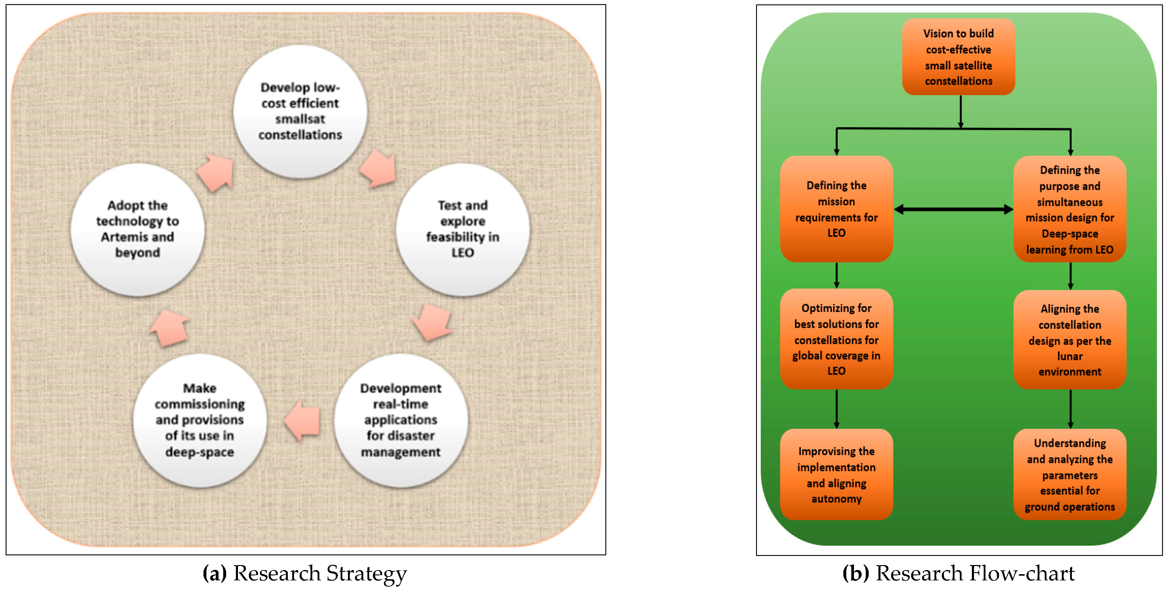
In the near future, this research will be further enhanced with unique techniques to control and effectively implement autonomous functions in small satellites, overcoming their constraints such as compact size and on-board resource availability and improve the functions in constellations. Additionally, the verifications for the optimization of the constellation coverage may be carried out in the near future to test the method on the real-time constellations. The social implementation of this technique in real-time will depend on the realization of effective constellations in the near future. There are plans to validate this technique through current constellations through a collaborative effort, which is under due consideration mainly to contribute towards the disaster management applications. This is not only for the real-time applications in a cost-effective manner in LEO, but also to support and strategize deep-space missions efficiently for a long-term operation and productive lifecycles.
Figure 23 describes the direction and focus of this research pictorially and Ref. [
32] adds essence to continuous research for small satellites constellations.
