Evaluation of Mangrove Wetlands Protection Patterns in the Guangdong–Hong Kong–Macao Greater Bay Area Using Time-Series Landsat Imageries
Abstract
1. Introduction
2. Materials and Methods
2.1. Study Area of Nature Reserves
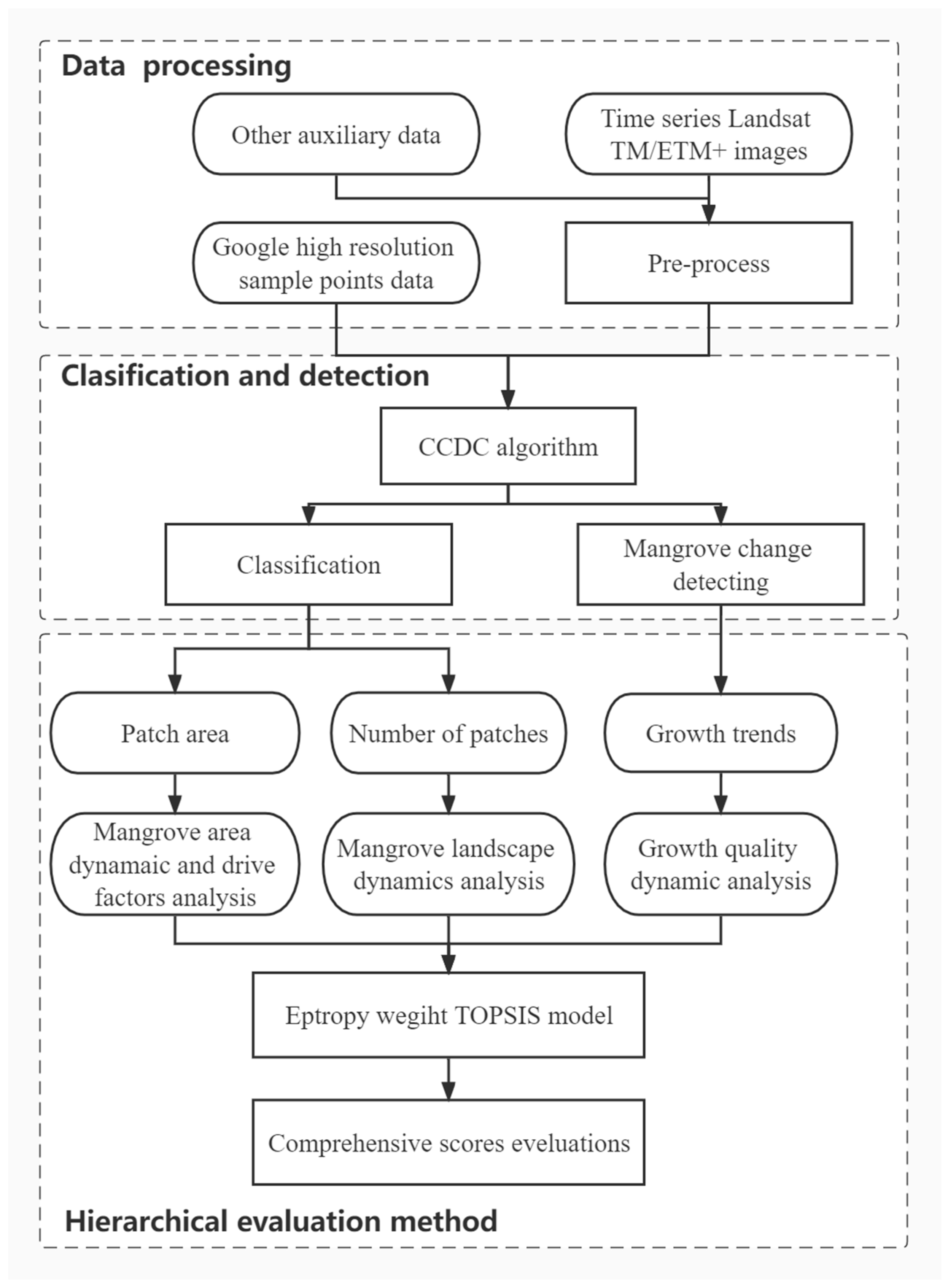
2.2. Data Source and Processing
2.3. Hierarchical Evaluation Method
2.3.1. Long-Term Mangrove Dynamics with CCDC
- x: Julian date
- i: The ith Landsat Band (i = 1, 2, 3, 4, 5, and 7)
- k: Temporal frequency of the harmonic component (k = 1, 2, and 3)
- T: Number of days per year (T = 365.25)
- a0,i: Coefficient for overall value for the ith Landsat Band
- c1,i: Coefficient for inter-annual change (slope) for the ith Landsat band
- ak,i, bk,i: Coefficients for intra-annual change, intra-annual bimodal change, and intra-annual trimodal change for the ith Landsat band, k = 1, 2, and 3, respectively.
2.3.2. Accuracy Assessment for Mangrove Changes
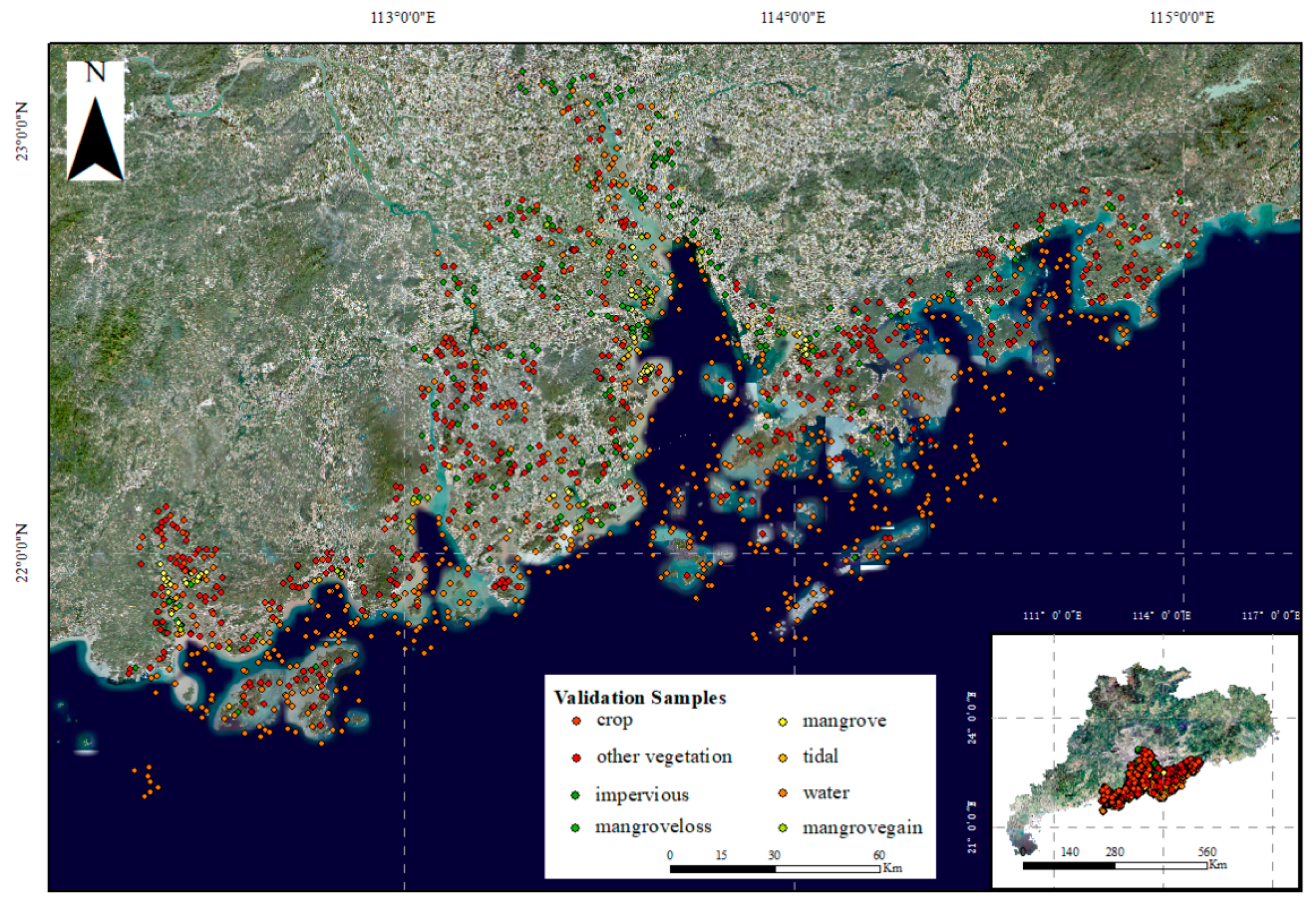
2.3.3. Spatiotemporal Area and Landscape Pattern Dynamics
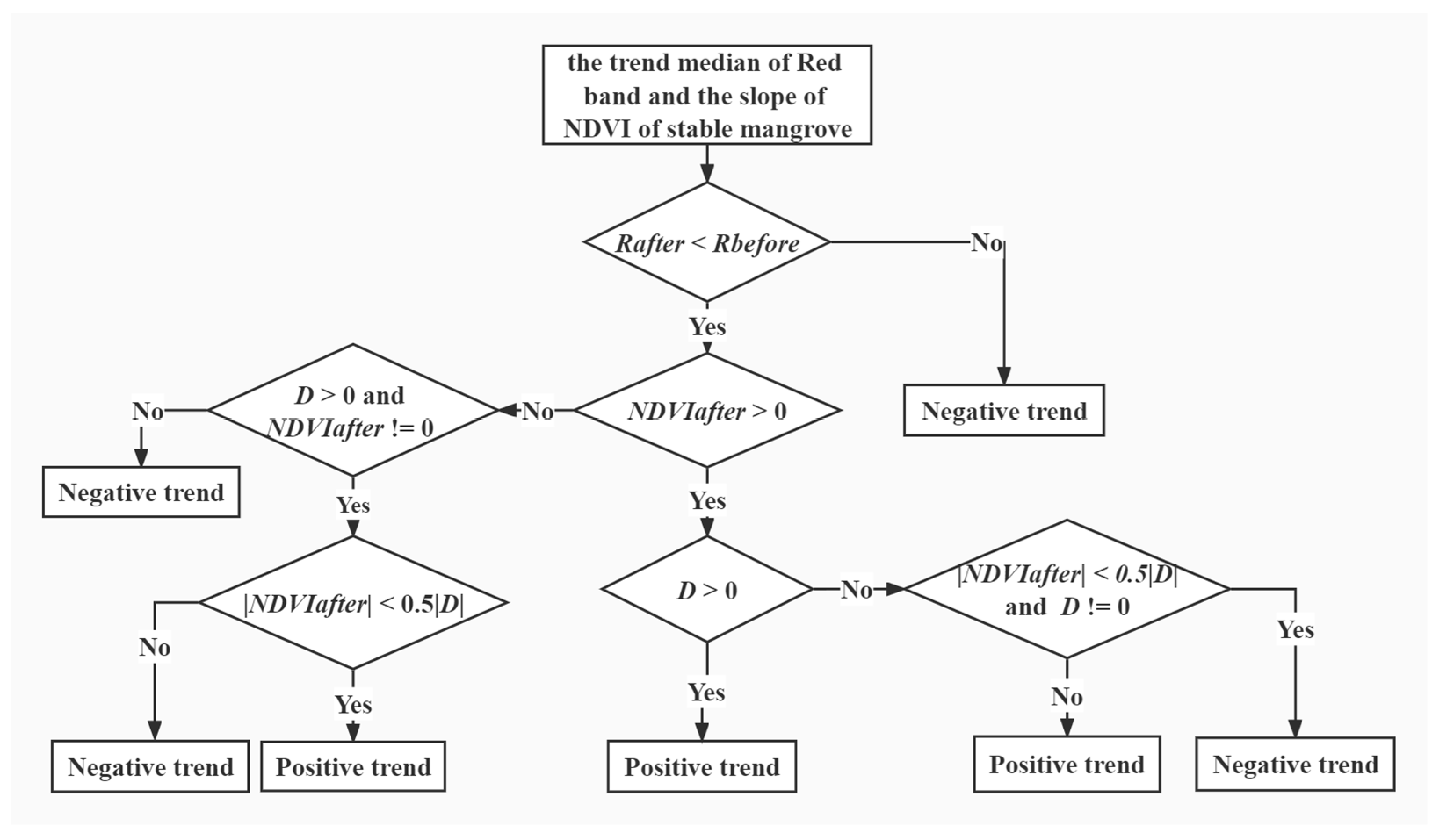
2.3.4. Growth Trends of Stable Mangrove
2.3.5. Comprehensive Score Evaluation Using the Entropy Weight TOPSIS Method
- Data normalization.
- b.
- Information entropy calculation.
- c.
- Weight calculation.
- Calculate the weighted normalized decision matrix by Equation (6).where , j = 1, 2, ⋯, n so that = 1, and is the original weight given to the indicator jth, j = 1, 2, ⋯, n.
- Determine the worst alternative and the best alternative by Equation (7).
- Calculate the weighted European-type distance between the target sample i and the best/worse condition by Equation (8).where is the weighted European-type distance between the worst solution and object; is the weighted European-type distance between the best solution and object.
- Calculate the similarity to the worst condition.
3. Results and Analysis
3.1. Accuracy Assessment
3.2. Spatiotemporal Dynamics in Nature Reserves
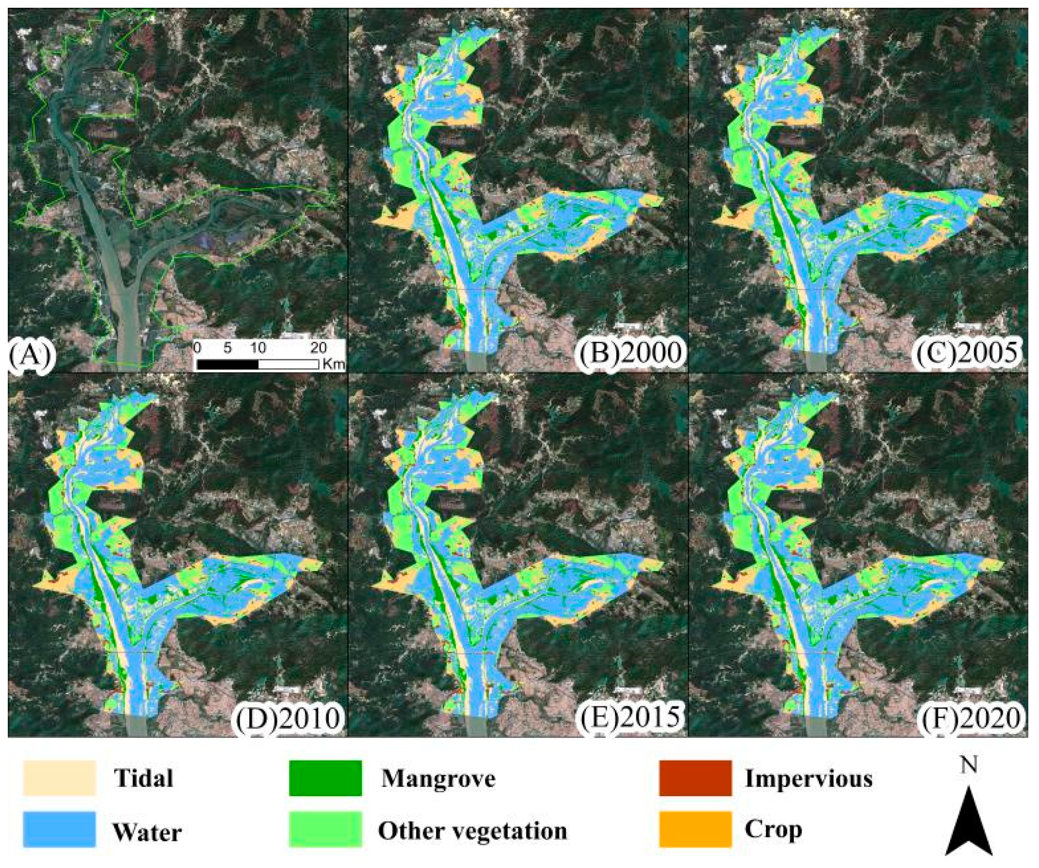
3.2.1. Classification Mapping
3.2.2. Mangrove Area Dynamics
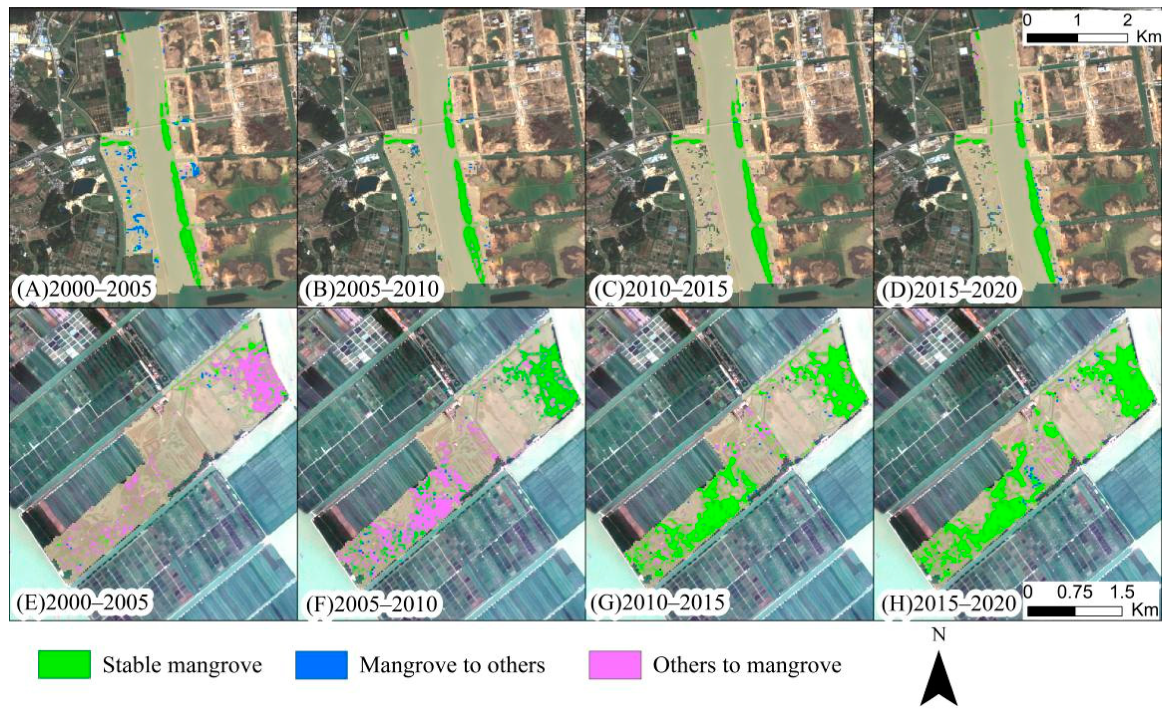
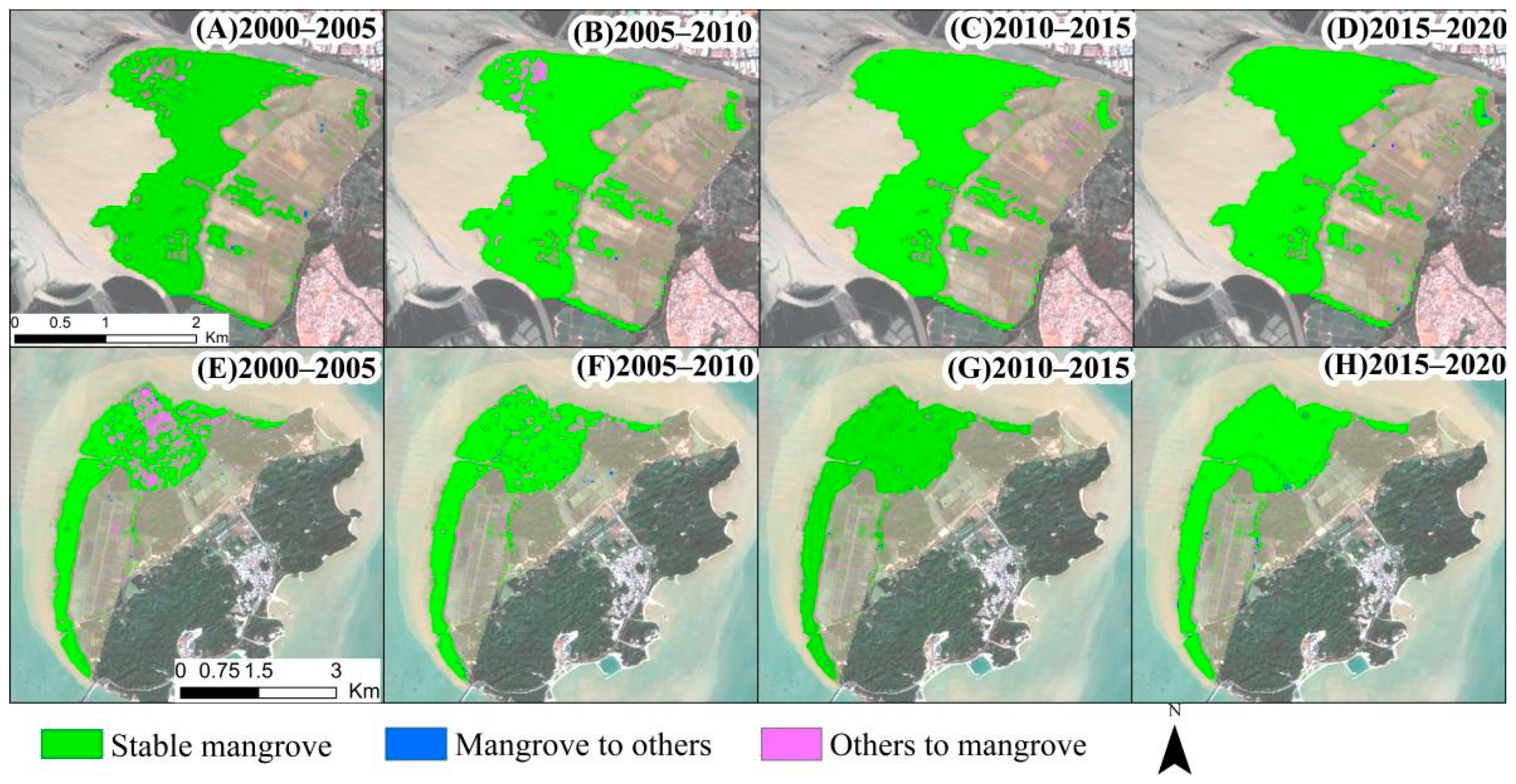
3.2.3. Mangrove Loss and Gain
3.2.4. Influence of Main Drive Factors on Mangrove
3.3. Landscape Pattern of Mangrove
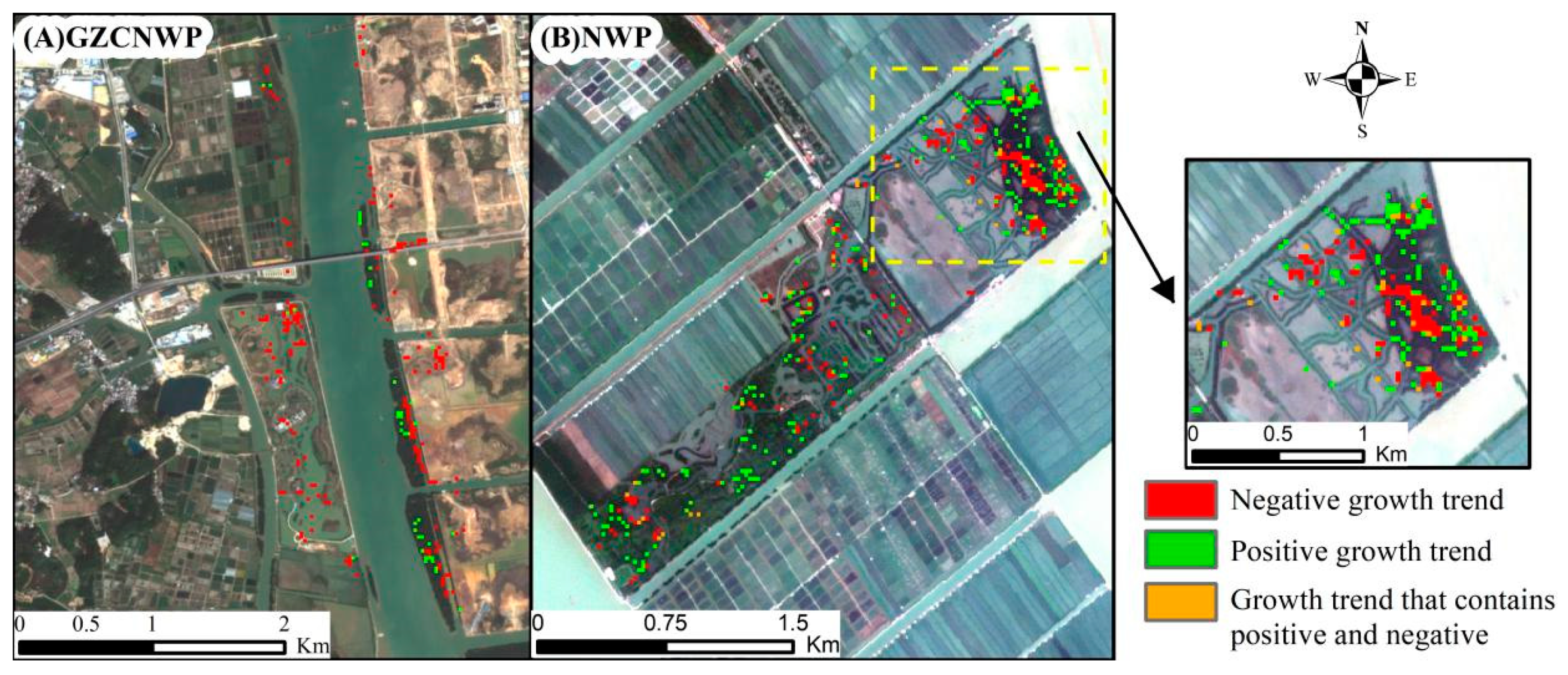
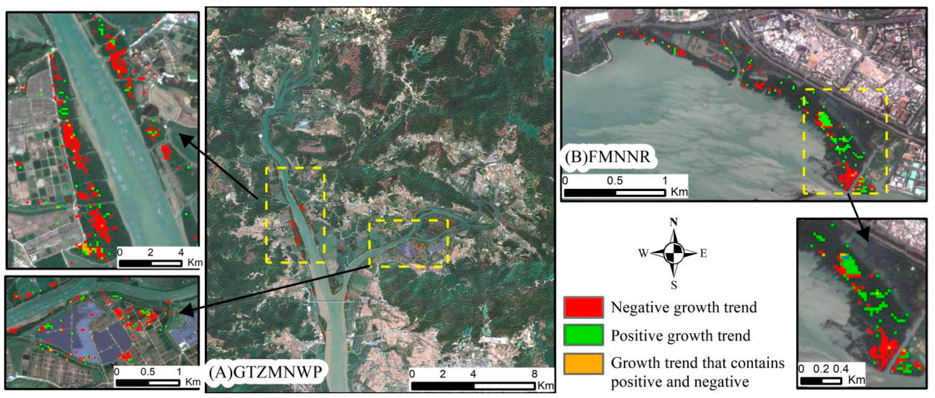
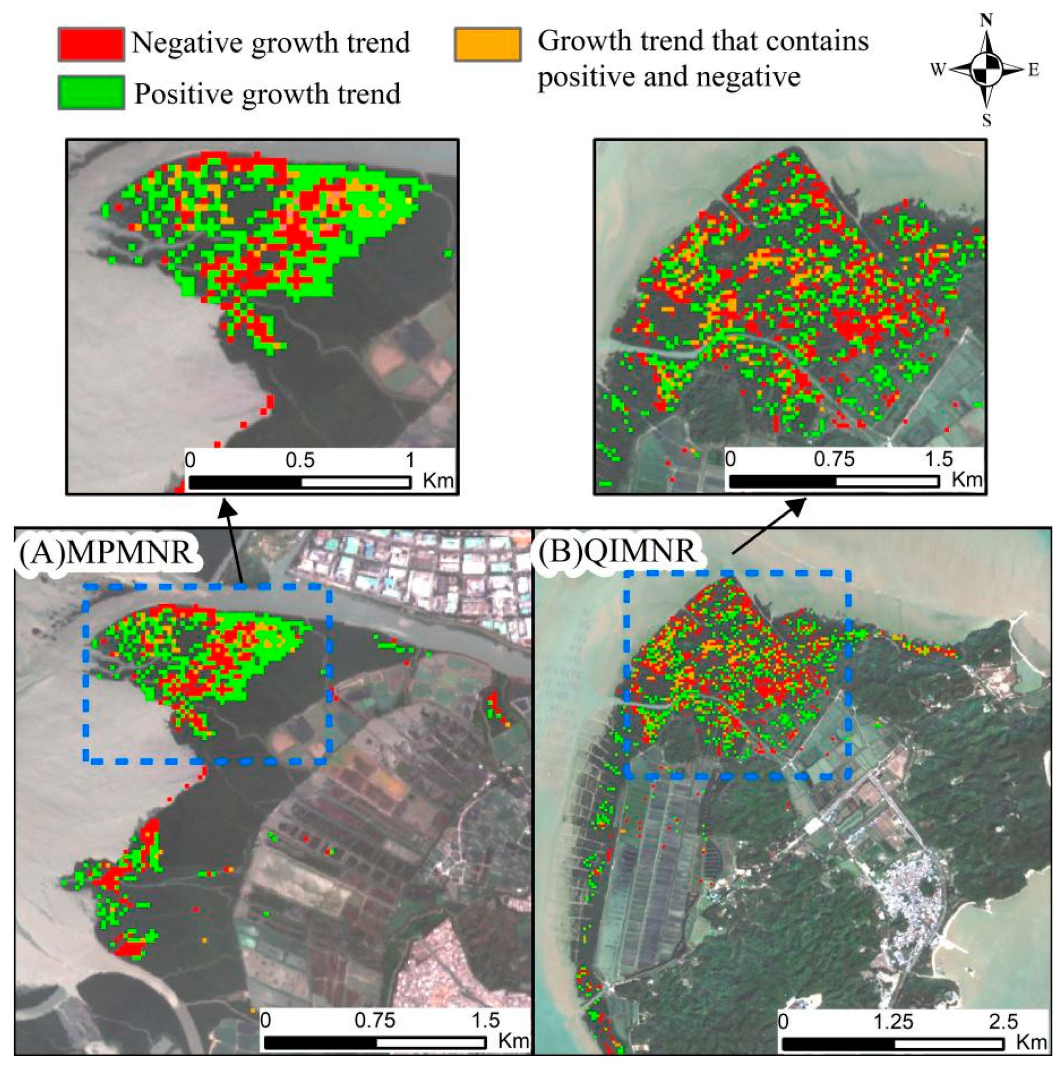
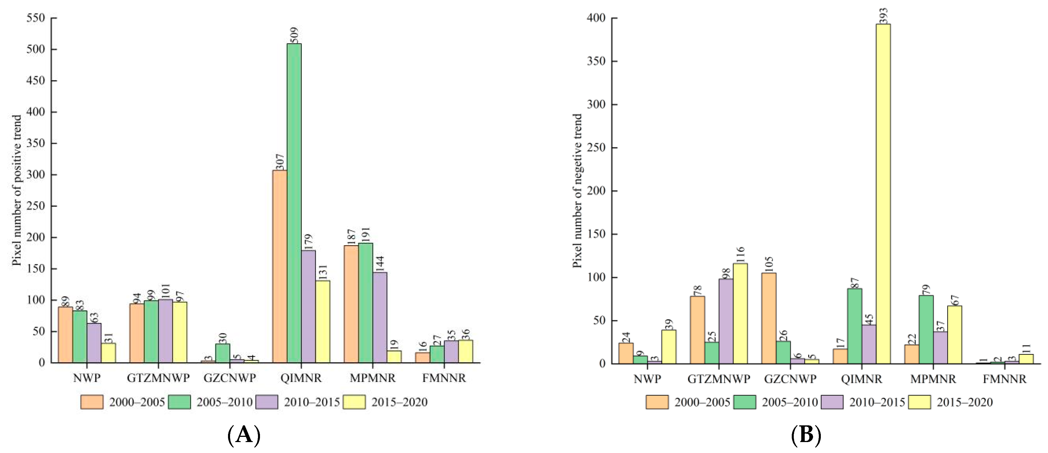
3.4. Mangrove Growth Trends
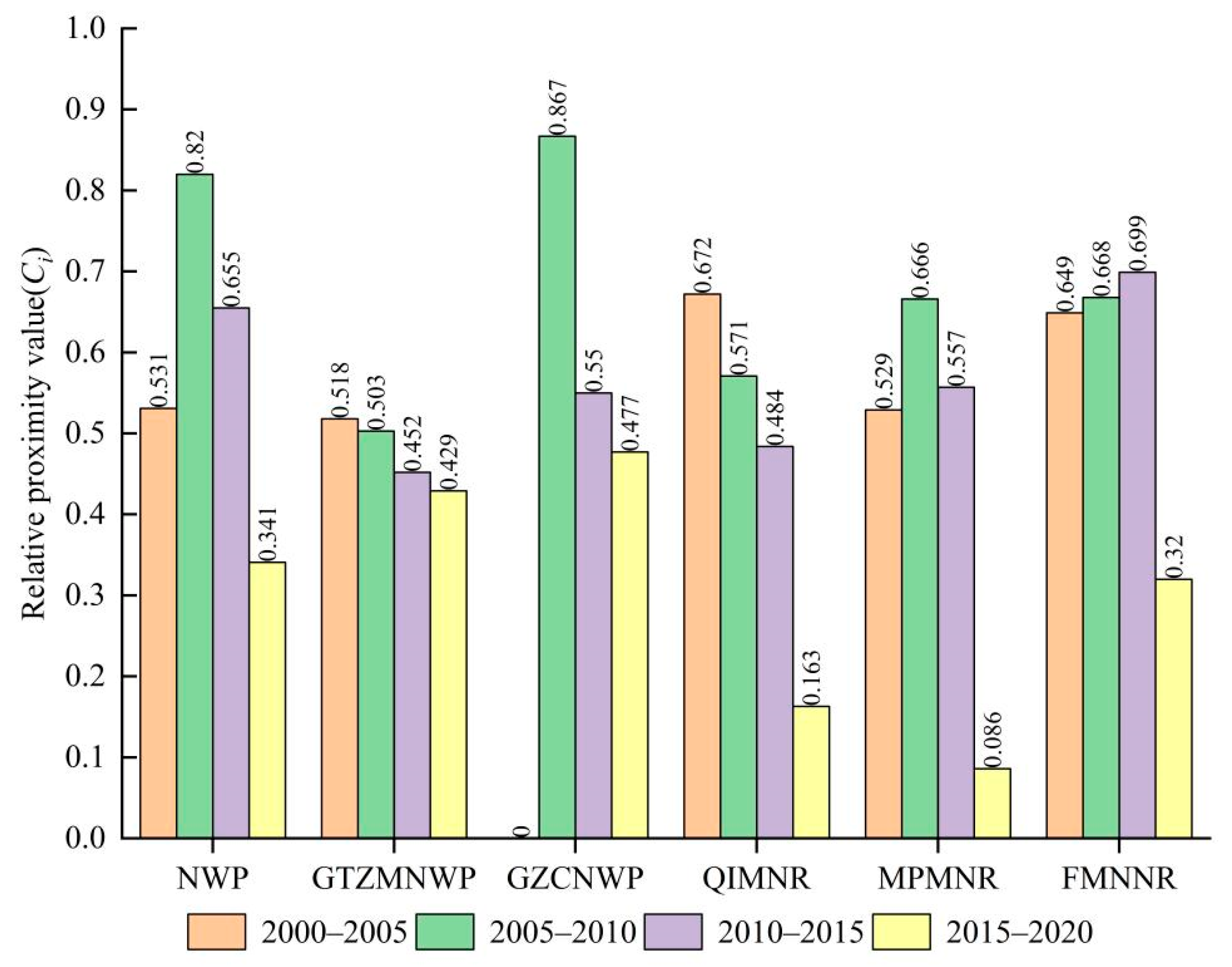
3.5. Comprehensive Score Evaluation
4. Discussion
4.1. Driving Factors Analysis of Mangrove Protection Dynamics
4.2. Advantages and Limitations of the Evaluation Method
5. Conclusions
Author Contributions
Funding
Data Availability Statement
Conflicts of Interest
Appendix A



| GTZMNWP Pixel | m | ||||
|---|---|---|---|---|---|
| D ≤ 50 | 50 < D ≤ 100 | 100 < D ≤ 200 | 200 < D ≤ 500 | 500 < D | |
| 2000–2005 | 143 | 16 | 5 | 0 | 0 |
| 2005–2010 | 313 | 8 | 9 | 2 | 0 |
| 2010–2015 | 170 | 24 | 8 | 6 | 0 |
| 2015–2020 | 162 | 75 | 48 | 15 | 0 |
| GZCNWP Pixel | m | ||||
|---|---|---|---|---|---|
| D ≤ 50 | 50 < D ≤ 100 | 100 < D ≤ 200 | 200 < D ≤ 500 | 500 < D | |
| 2000–2005 | 167 | 20 | 17 | 5 | 0 |
| 2005–2010 | 47 | 8 | 2 | 0 | 0 |
| 2010–2015 | 11 | 1 | 1 | 0 | 0 |
| 2015–2020 | 55 | 1 | 0 | 0 | 0 |
| QIMNR Pixel | m | |||||
|---|---|---|---|---|---|---|
| D ≤ 50 | 50 < D ≤ 100 | 100 < D ≤ 200 | 200 < D ≤ 500 | 500 < D ≤ 1000 | 1000 < D | |
| 2000–2005 | 7 | 3 | 1 | 2 | 1 | 7 |
| 2005–2010 | 8 | 1 | 4 | 6 | 6 | 6 |
| 2010–2015 | 5 | 2 | 1 | 2 | 2 | 0 |
| 2015–2020 | 8 | 9 | 7 | 18 | 1 | 0 |
| MPMNR Pixel | m | ||||
|---|---|---|---|---|---|
| D ≤ 50 | 50 < D ≤ 100 | 100 < D ≤ 200 | 200 < D ≤ 500 | 500 < D | |
| 2000–2005 | 4 | 1 | 0 | 0 | 0 |
| 2005–2010 | 0 | 0 | 1 | 0 | 0 |
| 2010–2015 | 0 | 0 | 0 | 0 | 0 |
| 2015–2020 | 5 | 1 | 1 | 0 | 1 |
References
- Wang, H.; Peng, Y.; Wang, C.; Wen, Q.; Xu, J.; Hu, Z.; Jia, X.; Zhao, X.; Lian, W.; Temmerman, S.; et al. Mangrove Loss and Gain in a Densely Populated Urban Estuary: Lessons From the Guangdong-Hong Kong-Macao Greater Bay Area. Front. Mar. Sci. 2021, 8, 693450. [Google Scholar] [CrossRef]
- Carugati, L.; Gatto, B.; Rastelli, E.; Lo Martire, M.; Coral, C.; Greco, S.; Danovaro, R. Impact of mangrove forests degradation on biodiversity and ecosystem functioning. Sci. Rep. 2018, 8, 13298. [Google Scholar] [CrossRef]
- Goldberg, L.; Lagomasino, D.; Thomas, N.; Fatoyinbo, T. Global declines in human-driven mangrove loss. Glob. Chang. Biol. 2020, 26, 5844–5855. [Google Scholar] [CrossRef] [PubMed]
- Murray, N.J.; Worthington, T.; Bunting, P.; Duce, S.; Hagger, V.; Lovelock, C.; Lucas, R.; Saunders, M.I.; Sheaves, M.; Spalding, M.; et al. High-resolution mapping of losses and gains of Earth’s tidal wetlands. Science 2022, 376, 744–749. [Google Scholar] [CrossRef]
- Friess, D.A.; Rogers, K.; Lovelock, C.E.; Krauss, K.W.; Hamilton, S.E.; Lee, S.Y.; Lucas, R.; Primavera, J.; Rajkaran, A.; Shi, S. The State of the World’s Mangrove Forests: Past, Present, and Future. Annu. Rev. Environ. Resour. 2019, 44, 89–115. [Google Scholar] [CrossRef]
- Fu, X.; Tang, H.; Liu, Y.; Zhang, M.; Jiang, S.; Yang, F.; Li, X.; Wang, C. Resource status and protection strategies of mangroves in China. J. Coast. Conserv. 2021, 25, 42. [Google Scholar] [CrossRef]
- Thomas, N.; Lucas, R.; Bunting, P.; Hardy, A.; Rosenqvist, A.; Simard, M. Distribution and drivers of global mangrove forest change, 1996–2010. PLoS ONE 2017, 12, e0179302. [Google Scholar] [CrossRef] [PubMed]
- Almeida, L.T.D.; Olímpio, J.L.S.; Pantalena, A.F.; Almeida, B.S.D.; Oliveira Soares, M.D. Evaluating ten years of management effectiveness in a mangrove protected area. Ocean Coast. Manag. 2016, 125, 29–37. [Google Scholar] [CrossRef]
- Miteva, D.A.; Murray, B.C.; Pattanayak, S.K. Do protected areas reduce blue carbon emissions? A quasi-experimental evaluation of mangroves in Indonesia. Ecol. Econ. 2015, 119, 127–135. [Google Scholar] [CrossRef]
- Cavalcanti, V.F.; Soares, M.L.G.; Estrada, G.C.D.; Chaves, F.O. Evaluating Mangrove Conservation through the Analysis of Forest Structure Data. J. Coast. Res. 2009, 1, 390–394. [Google Scholar]
- Ribas, L.G.d.S.; Pressey, R.L.; Loyola, R.; Bini, L.M. A global comparative analysis of impact evaluation methods in estimating the effectiveness of protected areas. Biodivers. Conserv. 2020, 246, 108595. [Google Scholar] [CrossRef]
- Matthews, G.V.T. The Ramsar Covention on Wetlands; Its History and Development; Secretariat, R.C., Ed.; Imprimerie Dupuis SA: Gland, Switzerland, 2013; pp. 4–7. [Google Scholar]
- Fang, B.X.; Dan, X.Q. Chinese mangrove resources and protection. Cent. South For. Inventory Plan. 2001, 20, 25–30, 33. [Google Scholar]
- Chen, L.; Wang, W.; Zhang, Y.; Lin, G. Recent progresses in mangrove conservation, restoration and research in China. J. Plant Ecol. 2009, 2, 45–54. [Google Scholar] [CrossRef]
- Rodrigues, A.S.L.; Cazalis, V. The multifaceted challenge of evaluating protected area effectiveness. Nat. Commun. 2020, 11, 5147. [Google Scholar] [CrossRef] [PubMed]
- Bryan-Brown, D.N.; Connolly, R.M.; Richards, D.R.; Adame, F.; Friess, D.A.; Brown, C.J. Global trends in mangrove forest fragmentation. Sci. Rep. 2020, 10, 7117. [Google Scholar] [CrossRef]
- Luo, S.; Chui, T.F. Annual variations in regional mangrove cover in southern China and potential macro-climatic and hydrological indicators. Ecol. Indic. 2020, 110, 105927. [Google Scholar] [CrossRef]
- Jia, M.; Wang, Z.; Zhang, Y.; Mao, D.; Wang, C. Monitoring loss and recovery of mangrove forests during 42 years: The achievements of mangrove conservation in China. Int. J. Appl. Earth. Obs. Geoinf. 2018, 73, 535–545. [Google Scholar] [CrossRef]
- Shah, P.; Baylis, K.; Busch, J.; Engelmann, J. What determines the effectiveness of national protected area networks? Environ. Res. Lett. 2021, 16, 074017. [Google Scholar] [CrossRef]
- Zheng, Y.; Zhang, H.; Niu, Z.; Gong, P. Protection efficacy of national wetland reserves in China. Chin. Sci. Bull. 2012, 57, 1116–1134. [Google Scholar] [CrossRef]
- Tue, N.T.; Dung, L.V.; Nhuan, M.T.; Omori, K. Carbon storage of a tropical mangrove forest in Mui Ca Mau National Park, Vietnam. Catena 2014, 121, 119–126. [Google Scholar] [CrossRef]
- Jia, M.; Liu, M.; Wang, Z.; Mao, D.; Ren, C.; Cui, H. Evaluating the Effectiveness of Conservation on Mangroves: A Remote Sensing-Based Comparison for Two Adjacent Protected Areas in Shenzhen and Hong Kong, China. Remote Sens. 2016, 8, 627. [Google Scholar] [CrossRef]
- Borges, R.; Ferreira, A.C.; Lacerda, L.D. Systematic Planning and Ecosystem-Based Management as Strategies to Reconcile Mangrove Conservation with Resource Use. Front. Mar. Sci. 2017, 4, 353. [Google Scholar] [CrossRef]
- Geldmann, J.; Manica, A.; Burgess, N.D.; Coad, L.; Balmford, A. A global-level assessment of the effectiveness of protected areas at resisting anthropogenic pressures. Proc. Natl. Acad. Sci. USA 2019, 116, 23209–23215. [Google Scholar] [CrossRef]
- Zhu, Z.; Fu, Y.; Woodcock, C.E.; Olofsson, P.; Vogelmann, J.E.; Holden, C.; Wang, M.; Dai, S.; Yu, Y. Including land cover change in analysis of greenness trends using all available Landsat 5, 7, and 8 images: A case study from Guangzhou, China (2000–2014). Remote Sens. Environ. 2016, 185, 243–257. [Google Scholar] [CrossRef]
- Loveland, T.R.; Anderson, M.C.; Huntington, J.L.; Irons, J.R.; Johnson, D.M.; Rocchio, L.E.P.; Woodcock, C.E.; Wulder, M.A. Seeing Our Planet Anew: Fifty Years of Landsat. Photogramm. Eng. Remote Sens. 2022, 88, 429–436. [Google Scholar] [CrossRef]
- Wulder, M.A.; Roy, D.P.; Radeloff, V.C.; Loveland, T.R.; Anderson, M.C.; Johnson, D.M.; Healey, S.; Zhu, Z.; Scambos, T.A.; Pahlevan, N.; et al. Fifty years of Landsat science and impacts. Remote Sens. Environ. 2022, 280, 113195. [Google Scholar] [CrossRef]
- Nguyen, T.H.; Jones, S.; Soto-Berelov, M.; Haywood, A.; Hislop, S. Landsat Time-Series for Estimating Forest Aboveground Biomass and Its Dynamics across Space and Time: A Review. Remote Sens. 2019, 12, 98. [Google Scholar] [CrossRef]
- Zhou, C.; Wei, X.; Zhou, G.; Yan, J.; Wang, X.; Wang, C.; Liu, H.; Tang, X.; Zhang, Q. Impacts of a large-scale reforestation program on carbon storage dynamics in Guangdong, China. For. Ecol. Manag. 2008, 255, 847–854. [Google Scholar] [CrossRef]
- Li, J.; Wang, F.; Fu, Y.; Guo, B.; Zhao, Y.; Yu, H. A Novel SUHI Referenced Estimation Method for Multicenters Urban Agglomeration using DMSP/OLS Nighttime Light Data. IEEE J. Sel. Top. Appl. Earth Obs. Remote Sens. 2020, 13, 1416–1425. [Google Scholar] [CrossRef]
- Zhao, J.; Yu, L.; Xu, Y.; Ren, H.; Huang, X.; Gong, P. Exploring the addition of Landsat 8 thermal band in land-cover mapping. Int. J. Remote Sens. 2019, 40, 4544–4559. [Google Scholar] [CrossRef]
- Ghosh, S.; Mishra, D.R.; Gitelson, A.A. Long-term monitoring of biophysical characteristics of tidal wetlands in the northern Gulf of Mexico—A methodological approach using MODIS. Remote Sens. Environ. 2016, 173, 39–58. [Google Scholar] [CrossRef]
- Li, Z.; Feng, Y.; Dessay, N.; Delaitre, E.; Gurgel, H.; Gong, P. Continuous Monitoring of the Spatio-Temporal Patterns of Surface Water in Response to Land Use and Land Cover Types in a Mediterranean Lagoon Complex. Remote Sens. 2019, 11, 1425. [Google Scholar] [CrossRef]
- Zhu, Z.; Woodcock, C.E. Continuous change detection and classification of land cover using all available Landsat data. Remote Sens. Environ. 2014, 144, 152–171. [Google Scholar] [CrossRef]
- Wang, X.; Li, R.; Ding, H.; Fu, Y. Fine-Scale Improved Carbon Bookkeeping Model Using Landsat Time Series for Subtropical Forest, Southern China. Remote Sens. 2022, 14, 753. [Google Scholar] [CrossRef]
- Awty-Carroll, K.; Bunting, P.; Hardy, A.; Bell, G. Using Continuous Change Detection and Classification of Landsat Data to Investigate Long-Term Mangrove Dynamics in the Sundarbans Region. Remote Sens. 2019, 11, 2833. [Google Scholar] [CrossRef]
- Fu, Y.C.; Yu, Y. Exploring the greening trends in Guangzhou in recently 15 years using all available Landsat’s images. IGARSS 2016, 7, 2312–2315. [Google Scholar]
- Zhu, Z.; Woodcock, C.E.; Olofsson, P. Continuous monitoring of forest disturbance using all available Landsat imagery. Remote Sens. Environ. 2012, 122, 75–91. [Google Scholar] [CrossRef]
- Edwards, D.P.; Larsen, T.H.; Docherty, T.D.; Ansell, F.A.; Hsu, W.W.; Derhe, M.A.; Hamer, K.C.; Wilcove, D.S. Degraded lands worth protecting: The biological importance of Southeast Asia’s repeatedly logged forests. Proc. Biol. Sci. 2011, 278, 82–90. [Google Scholar] [CrossRef]
- Hwang, C.L.; Yoon, K. Multiple Attribute Decision Making: Methods and Applications, 1st ed.; Springer: Berlin/Heidelberg, Germany, 2011. [Google Scholar]
- Min, W.; Shuhao, L. Research on the measurement of China’s high quality economic development level in the new era. Res. Quant. Econ. Technol. Econ. 2018, 35, 3–20. [Google Scholar]
- Zuo, Q.T.; Zhang, Z.Z.; Wu, B.B. Evaluation of Water Resources carrying capacity of the Yellow River Basin based on combined weight TOPSIS model. Water Resour. Prot. 2020, 36, 1–7. [Google Scholar]
- Wu, H.Y.; Liu, W.Q.; Zheng, J.; Li, C.M. Summary of the Climate of Guangdong Province in 2015. Guangdong Meteorol. 2016, 38, 1–5. [Google Scholar]
- Zhao, C.; Qin, C.-Z.; Teng, J. Mapping large-area tidal flats without the dependence on tidal elevations: A case study of Southern China. ISPRS J. Photogramm. Remote Sens. 2020, 159, 256–270. [Google Scholar] [CrossRef]
- Masek, J.G.; Vermote, E.F.; Saleous, N.E.; Wolfe, R.; Hall, F.G.; Huemmrich, K.F.; Gao, F.; Kutler, J.; Lim, T.K. A Landsat Surface Reflectance Dataset for North America, 1990–2000. IEEE Geosci. Remote Sens. Lett. 2006, 3, 68–72. [Google Scholar] [CrossRef]
- Chen, B.; Xiao, X.; Li, X.; Pan, L.; Doughty, R.; Ma, J.; Dong, J.; Qin, Y.; Zhao, B.; Wu, Z.; et al. A mangrove forest map of China in 2015: Analysis of time series Landsat 7/8 and Sentinel-1A imagery in Google Earth Engine cloud computing platform. ISPRS J. Photogramm. Remote Sens. 2017, 131, 104–120. [Google Scholar] [CrossRef]
- Lee, S.Y.; Hamilton, S.; Barbier, E.B.; Primavera, J.; Lewis, R.R. 3rd Better restoration policies are needed to conserve mangrove ecosystems. Nat. Ecol. Evol. 2019, 3, 870–872. [Google Scholar] [CrossRef] [PubMed]
- Suyadi; Gao, J.; Lundquist, C.J.; Schwendenmann, L. Characterizing landscape patterns in changing mangrove ecosystems at high latitudes using spatial metrics. Estuar. Coast. Shelf Sci. 2018, 215, 1–10. [Google Scholar] [CrossRef]
- Zhu, Z.; Woodcock, C.E.; Holden, C.; Yang, Z. Generating synthetic Landsat images based on all available Landsat data: Predicting Landsat surface reflectance at any given time. Remote Sens. Environ. 2015, 162, 67–83. [Google Scholar] [CrossRef]
- Cochran, W.G. Sampling techniques, 3rd ed.; John Wiley & Sons: New York, NY, America, 1977. [Google Scholar]
- Olofsson, P.; Foody, G.M.; Stehman, S.V.; Woodcock, C.E. Making better use of accuracy data in land change studies: Estimating accuracy and area and quantifying uncertainty using stratified estimation. Remote Sens. Environ. 2013, 129, 122–131. [Google Scholar] [CrossRef]
- Olofsson, P.; Foody, G.M.; Herold, M.; Stehman, S.V.; Woodcock, C.E.; Wulder, M.A. Good practices for estimating area and assessing accuracy of land change. Remote Sens. Environ. 2014, 148, 42–57. [Google Scholar] [CrossRef]
- Wu, J.G. Landscape Ecology: Pattern, Process, Scale and Hierarchy, 2nd ed.; Higher Education Press: Beijing, China, 2007; pp. 106–121. [Google Scholar]
- Bunting, P.; Rosenqvist, A.; Hilarides, L.; Lucas, R.M.; Thomas, N.; Tadono, T.; Worthington, T.A.; Spalding, M.; Murray, N.J.; Rebelo, L.-M. Global Mangrove Extent Change 1996–2020: Global Mangrove Watch Version 3.0. Remote Sens. 2022, 14, 3657. [Google Scholar] [CrossRef]
- Richards, D.R.; Friess, D.A. Rates and drivers of mangrove deforestation in Southeast Asia, 2000–2012. Proc. Natl. Acad. Sci. USA 2016, 113, 344–349. [Google Scholar] [CrossRef] [PubMed]
- Critchley, L.P.; Bugnot, A.B.; Dafforn, K.A.; Marzinelli, E.M.; Bishop, M.J. Comparison of wrack dynamics between mangrove forests with and without seawalls. Sci. Total. Environ. 2021, 751, 141371. [Google Scholar] [CrossRef] [PubMed]
- Feng, Z.; Tan, G.; Xia, J.; Shu, C.; Chen, P.; Wu, M.; Wu, X. Dynamics of mangrove forests in Shenzhen Bay in response to natural and anthropogenic factors from 1988 to 2017. J. Hydrol. 2020, 591, 125271. [Google Scholar] [CrossRef]
- Hu, Y.; Batunacun; Zhen, L.; Zhuang, D. Assessment of Land-Use and Land-Cover Change in Guangxi, China. Sci. Rep. 2019, 9, 2189. [Google Scholar] [CrossRef] [PubMed]
- Zhu, B.; Liao, J.; Shen, G. Combining time series and land cover data for analyzing spatio-temporal changes in mangrove forests: A case study of Qinglangang Nature Reserve, Hainan, China. Ecol. Indic. 2021, 131, 108135. [Google Scholar] [CrossRef]
- Zheng, Y.; Takeuchi, W. Quantitative Assessment and Driving Force Analysis of Mangrove Forest Changes in China from 1985 to 2018 by Integrating Optical and Radar Imagery. ISPRS Int. J. Geoinf. 2020, 9, 513. [Google Scholar] [CrossRef]
- Zhang, Y.Q.; Zhang, Z.; Jiang, B.Q.; Shen, X.Y.; Li, R.L. Ecosystem health assessment and management strategies of typical urban mangroves in Guangdong-Hongkog-Macao Greater Bay Area. China Environ. Sci. 2022, 42, 2352–2369. [Google Scholar]
- Geldmann, J.; Coad, L.; Barnes, M.; Craigie, I.D.; Hockings, M.; Knights, K.; Leverington, F.; Cuadros, I.C.; Zamora, C.; Woodley, S.; et al. Changes in protected area management effectiveness over time: A global analysis. Biol. Conserv. 2015, 191, 692–699. [Google Scholar] [CrossRef]
- Zhen, J.; Liao, J.; Shen, G. Mapping Mangrove Forests of Dongzhaigang Nature Reserve in China Using Landsat 8 and Radarsat-2 Polarimetric SAR Data. Sensors 2018, 18, 4012. [Google Scholar] [CrossRef]
- Ghorbanian, A.; Zaghian, S.; Asiyabi, R.M.; Amani, M.; Mohammadzadeh, A.; Jamali, S. Mangrove Ecosystem Mapping Using Sentinel-1 and Sentinel-2 Satellite Images and Random Forest Algorithm in Google Earth Engine. Remote Sens. 2021, 13, 2565. [Google Scholar] [CrossRef]
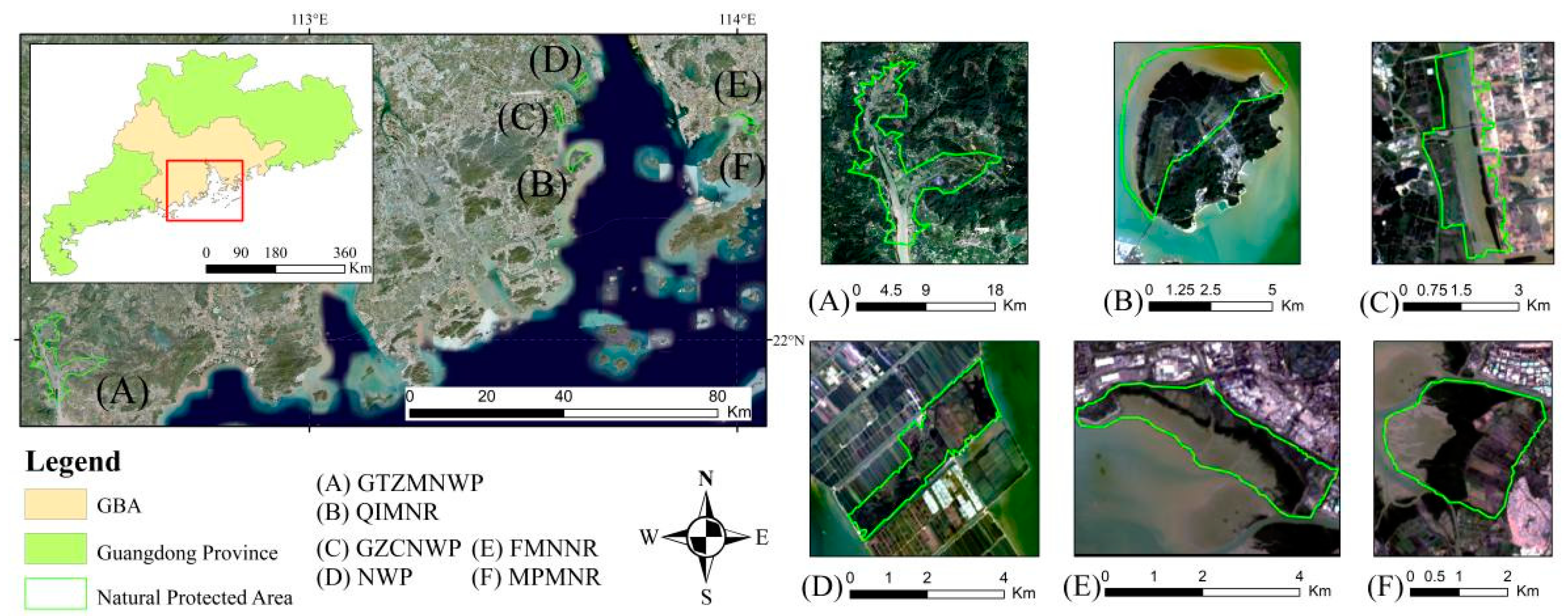


| Name of Reserve | Location | Climate Conditions | |||||
|---|---|---|---|---|---|---|---|
| Conservation Areas (ha) | Starting Time | Protection Type | Annual Average Temperature (℃) | Annual Average Precipitation (mm) | Climate Type | ||
| NWP | 22°26′–23°6′N 113°13′–113°43′E | 626.7 | 2014 | Local | 21.8 | 1635.6 | South Asian subtropical ocean monsoon climate |
| GTZMNWP | 21°44′–21°56′30″N 112°24′–112°33′E | 10,080 | 2004 | Local | 21.3~22.8 | 2183.3 | Tropical monsoon climate |
| GZCNWP | 22°30′–22°32′N 113°34′–113°35′E | 625.6 | 2017 | National | 21.6 | 1731 | Tropical monsoon climate |
| FMNNR | 114°03′E, 22°32′N | 368 | 1984 | National | 22.55 | 1926.8 | Sub-tropical maritime climate |
| MPMNR | 113°59′–114°03′E, 22°29′–22°31′N | 1500 | 1983 | National | 22.55 | 1926.8 | South Asian tropical monsoon climate |
| QIMNR | 113°36′40″–113°39′15″E 22°23′40″–22°27′38″N | 5103.77 | 1999 | Provincial | - | - | Tropical monsoon climate |
| Land Cover Type | Example Image | Definition |
|---|---|---|
| Mangrove |  | Growing mangrove plant communities with no obvious bare land or tidal flats |
| Water |  | Aquaculture without mangroves on the surface and base, seawater, rivers, and the landscape water inside the city |
| Impervious |  | Unutilized land, artificial features (such as villages, roads, and other construction land), or large tracts of wasteland partially occupied by construction |
| Other vegetation | 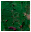 | The vegetation distributed in the suitable area of mangroves except for mangrove, including plants in cities, green plants near pond bases, and natural forest vegetation |
| Crop | 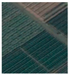 | Vegetation with a distinct stripped texture, green or light green in color |
| Tidal |  | Bare tidal with a clear separation from the water |
| Class | Ground Truth | (Pixels) | ||||||||
|---|---|---|---|---|---|---|---|---|---|---|
| Crop | Other Vegetation | Impervious | Mangrove | Tidal | Water | Mangrove Loss | Mangrove Gain | Total | Map AREA [ha] | |
| Crop | 93 | 1 | 0 | 0 | 0 | 4 | 0 | 0 | 98 | 79,156.70 |
| Other vegetation | 4 | 416 | 4 | 0 | 0 | 4 | 0 | 0 | 428 | 434,893.60 |
| Impervious | 1 | 1 | 176 | 0 | 0 | 1 | 0 | 0 | 179 | 165,427.31 |
| Mangrove | 0 | 4 | 0 | 62 | 1 | 0 | 2 | 1 | 70 | 2455.08 |
| Tidal | 0 | 0 | 0 | 0 | 49 | 0 | 0 | 0 | 49 | 9302.18 |
| Water | 0 | 0 | 1 | 0 | 0 | 602 | 0 | 0 | 603 | 966,564.66 |
| Mangrove loss | 0 | 6 | 0 | 0 | 2 | 0 | 20 | 2 | 30 | 1099.85 |
| Mangrove gain | 0 | 3 | 0 | 1 | 0 | 0 | 3 | 23 | 30 | 699.61 |
| Total | 98 | 431 | 181 | 63 | 52 | 611 | 25 | 26 | 1487 | 1,659,598.98 |
| Area-estimation (ha) | 80,106.69 | 424,862.43 | 168,322.14 | 2197.82 | 9410.57 | 973,181.22 | 873.34 | 644.76 | 1,659,598.98 | |
| Overall accuracy | 98.71% | |||||||||
| user accuracy | 94.90% | 97.20% | 98.32% | 88.57% | 100% | 99.83% | 66.67% | 76.67% | ||
| producer accuracy | 93.77% | 99.49% | 96.63% | 98.94% | 98.85% | 99.16% | 83.96% | 83.19% |
| Nature Reserve | Total Pixel | 2000 | 2005 | 2010 | 2015 | 2020 | |||||
|---|---|---|---|---|---|---|---|---|---|---|---|
| Pixel | % | Pixel | % | Pixel | % | Pixel | % | Pixel | % | ||
| NWP | 5415 | 131 | 2.419 | 743 | 13.721 | 1486 | 27.442 | 1660 | 30.656 | 1692 | 31.247 |
| GTZMNWP | 147,629 | 11,154 | 7.555 | 11,162 | 7.561 | 10,896 | 7.381 | 10,748 | 7.280 | 10,707 | 7.253 |
| GZCNWP | 7470 | 885 | 11.847 | 695 | 9.304 | 688 | 9.210 | 716 | 9.585 | 678 | 9.076 |
| QIMNR | 24,357 | 4332 | 17.785 | 5342 | 21.932 | 5705 | 23.422 | 5776 | 23.714 | 5783 | 23.743 |
| MPMNR | 9001 | 3257 | 36.185 | 3296 | 36.618 | 3415 | 37.940 | 3434 | 38.151 | 3443 | 38.251 |
| FMNNR | 5804 | 1366 | 23.535 | 1372 | 23.639 | 1384 | 23.846 | 1416 | 24.397 | 1442 | 24.845 |
| Change (%) | 2000–2005 | 2005–2010 | 2010–2015 | 2015–2020 | Total Net Change (%) |
|---|---|---|---|---|---|
| NWP | 11.302 | 13.721 | 3.213 | 0.591 | 28.827 |
| GTZMNWP | 0.005 | −0.180 | −0.100 | −0.028 | −0.303 |
| GZCNWP | −2.544 | −0.094 | 0.375 | −0.509 | −2.771 |
| QIMNR | 4.147 | 1.490 | 0.291 | 0.029 | 5.957 |
| MPMNR | 0.433 | 1.322 | 0.211 | 0.100 | 2.066 |
| FMNNR | 0.103 | 0.207 | 0.551 | 0.448 | 1.309 |
| Weight | F | MG | SMP | ML | SMN |
|---|---|---|---|---|---|
| NWP | 0.215 | 0.215 | 0.175 | 0.178 | 0.217 |
| GTZMNWP | 0.189 | 0.215 | 0.189 | 0.196 | 0.211 |
| GZCNWP | 0.150 | 0.164 | 0.228 | 0.209 | 0.248 |
| QIMNR | 0.157 | 0.241 | 0.179 | 0.174 | 0.249 |
| MPMNR | 0.160 | 0.221 | 0.191 | 0.252 | 0.177 |
| FMNNR | 0.171 | 0.190 | 0.174 | 0.230 | 0.235 |
Publisher’s Note: MDPI stays neutral with regard to jurisdictional claims in published maps and institutional affiliations. |
© 2022 by the authors. Licensee MDPI, Basel, Switzerland. This article is an open access article distributed under the terms and conditions of the Creative Commons Attribution (CC BY) license (https://creativecommons.org/licenses/by/4.0/).
Share and Cite
He, T.; Fu, Y.; Ding, H.; Zheng, W.; Huang, X.; Li, R.; Wu, S. Evaluation of Mangrove Wetlands Protection Patterns in the Guangdong–Hong Kong–Macao Greater Bay Area Using Time-Series Landsat Imageries. Remote Sens. 2022, 14, 6026. https://doi.org/10.3390/rs14236026
He T, Fu Y, Ding H, Zheng W, Huang X, Li R, Wu S. Evaluation of Mangrove Wetlands Protection Patterns in the Guangdong–Hong Kong–Macao Greater Bay Area Using Time-Series Landsat Imageries. Remote Sensing. 2022; 14(23):6026. https://doi.org/10.3390/rs14236026
Chicago/Turabian StyleHe, Tingting, Yingchun Fu, Hu Ding, Weiping Zheng, Xiaohui Huang, Runhao Li, and Shuting Wu. 2022. "Evaluation of Mangrove Wetlands Protection Patterns in the Guangdong–Hong Kong–Macao Greater Bay Area Using Time-Series Landsat Imageries" Remote Sensing 14, no. 23: 6026. https://doi.org/10.3390/rs14236026
APA StyleHe, T., Fu, Y., Ding, H., Zheng, W., Huang, X., Li, R., & Wu, S. (2022). Evaluation of Mangrove Wetlands Protection Patterns in the Guangdong–Hong Kong–Macao Greater Bay Area Using Time-Series Landsat Imageries. Remote Sensing, 14(23), 6026. https://doi.org/10.3390/rs14236026


