A Random Forest Model for Drought: Monitoring and Validation for Grassland Drought Based on Multi-Source Remote Sensing Data
Abstract
1. Introduction
2. Materials and Methods
2.1. Study Area Description
2.2. Data Sources and Processing
2.2.1. Meteorological Data
2.2.2. Remote Sensing Data
2.2.3. Statistical Data
2.3. Data Processing
2.3.1. Calculation of Standardized Precipitation Evapotranspiration Index (SPEI)
2.3.2. Processing of Remote Sensing Data
3. Drought Monitoring Model Construction
3.1. Principles of Grassland Drought Monitoring Model Construction
3.2. Vegetation Condition Index
3.3. Precipitation Condition Index (GPMI)
3.4. Temperature Condition Index (TCI)
3.5. Other Factors
3.6. Construction Process for a Grassland Drought Monitoring Model
- (1)
- Random repetitive sampling from the training dataset is repeated n times to generate n new training samples, while the unsampled samples constitute out-of-bag (OOB) data.
- (2)
- Each training sample constitutes a regression tree in a random forest, and at each node of the regression tree, m variables are randomly selected from six variables for branching. The out-of-bag error is estimated based on the out-of-bag data corresponding to the training sample. The regression trees generated from the training samples constitute the random forest. The random forest prediction result is the mean of the prediction results of all regression trees. The random forest prediction accuracy is then the mean of the out-of-bag errors for all regression trees.
- (3)
- The most important part of the model-building process is to determine the number of regression trees n and the number of preselected variables at tree nodes m. The number of m is determined in steps of 1 by looking at the value corresponding to their minimum error. In general, the number of m is not changed once it is determined. In addition, the number of m is smaller than that of the variables involved in the modeling.
- (4)
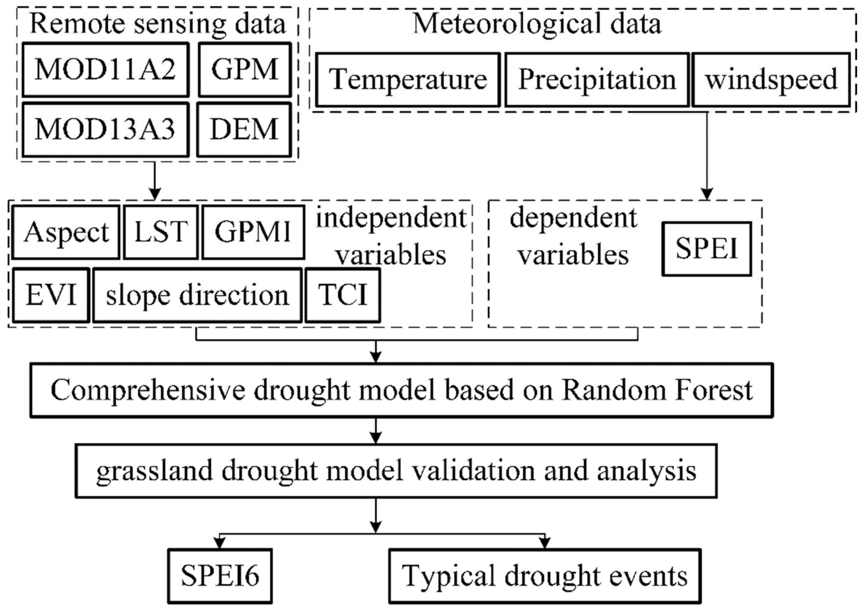
- The number of regression trees n was determined on the basis of m. The step size of n was incremented by 100, and the default was 500. After several trials, when m = 4 and n = 1000, the OOB error of this study was minimized. Consequently, we finally chose the following parameters as the initial input parameters of the model: m = 4 and n = 1000. With such a modeling process, we explored a better model for grassland drought monitoring.
4. Results
4.1. Model Calibration and Validation
4.2. Analysis of Model Monitoring Results
4.2.1. Analysis of Grassland Drought Monitoring Model Monitoring Results in Wet Years
4.2.2. Analysis of Grassland Drought Monitoring Model Monitoring Results in Normal Years
4.2.3. Analysis of Grassland Drought Monitoring Model Monitoring Results in Dry Years
5. Discussion
6. Conclusions
- (1)
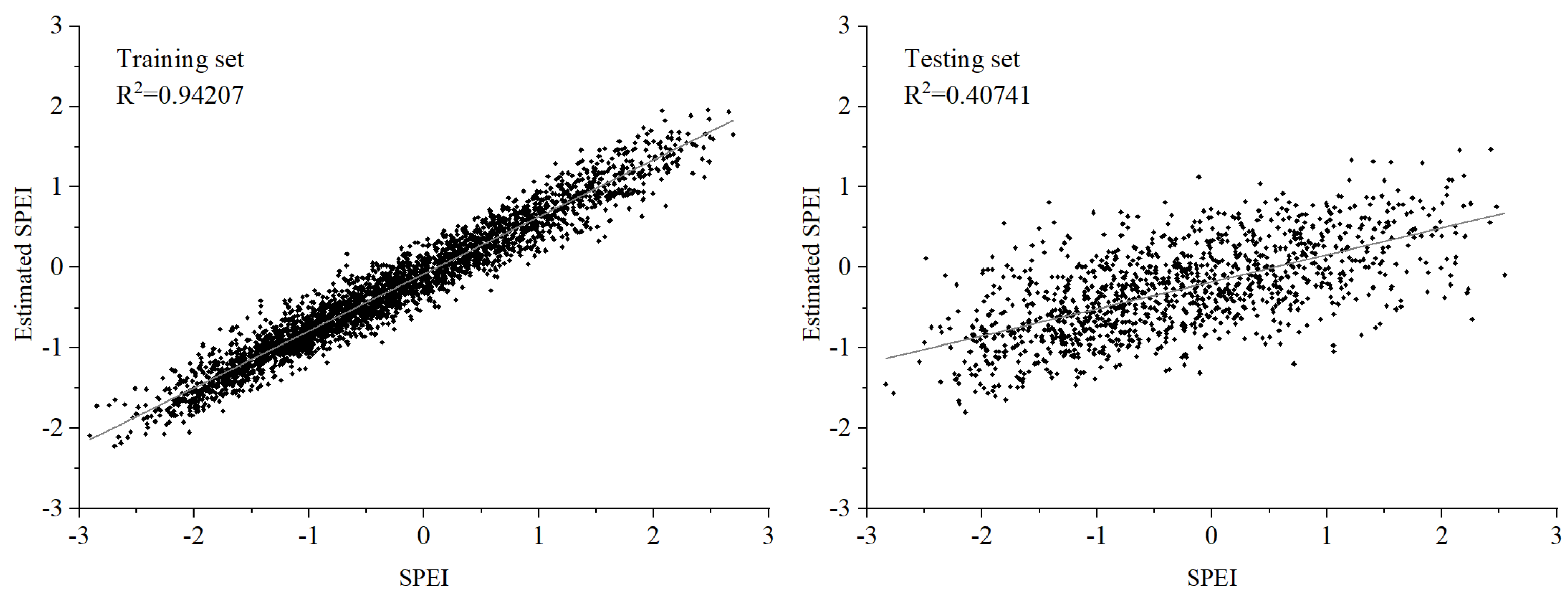
- The grassland drought monitoring model established in this study can quantitatively monitor the drought condition of the Inner Mongolia grassland. The correlation coefficient (R) between the drought level obtained from the model training set and the measured SPEI6 reached 0.9706, and the correlation coefficient between the drought level obtained from the model test set and the measured SPEI6 reached 0.6387.
- (2)
- The grassland drought monitoring model can objectively describe the degree of drought in the Inner Mongolia grassland. The correlation coefficient between the grassland drought index and the standardized precipitation evapotranspiration index (SPEI) from the model was 87.90%, demonstrating that the model can be used for drought monitoring and early warning of grassland drought in Inner Mongolia.
- (3)
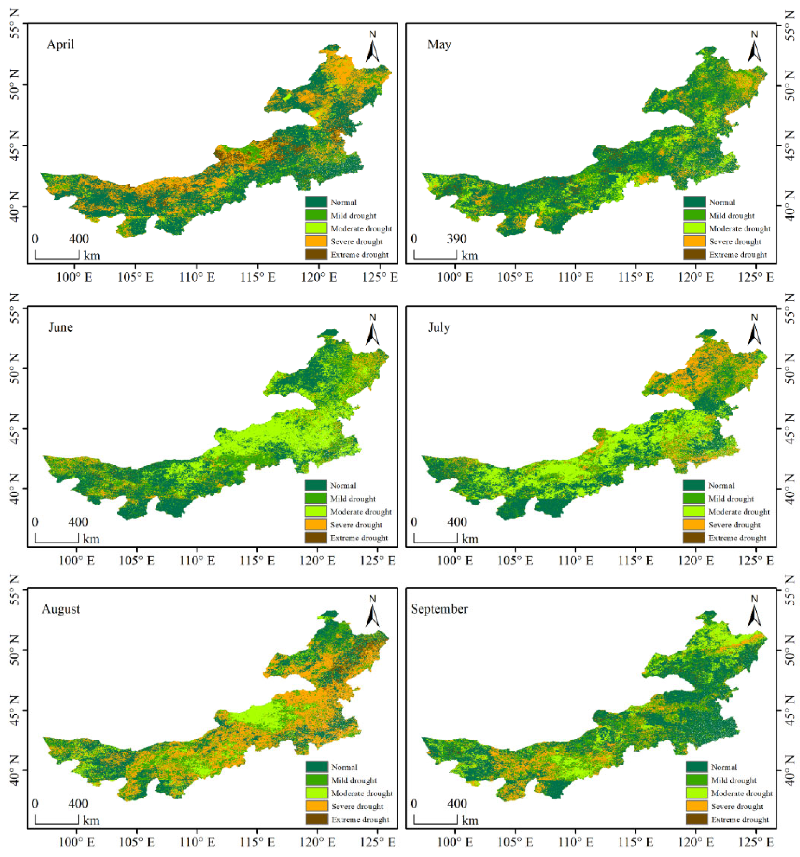
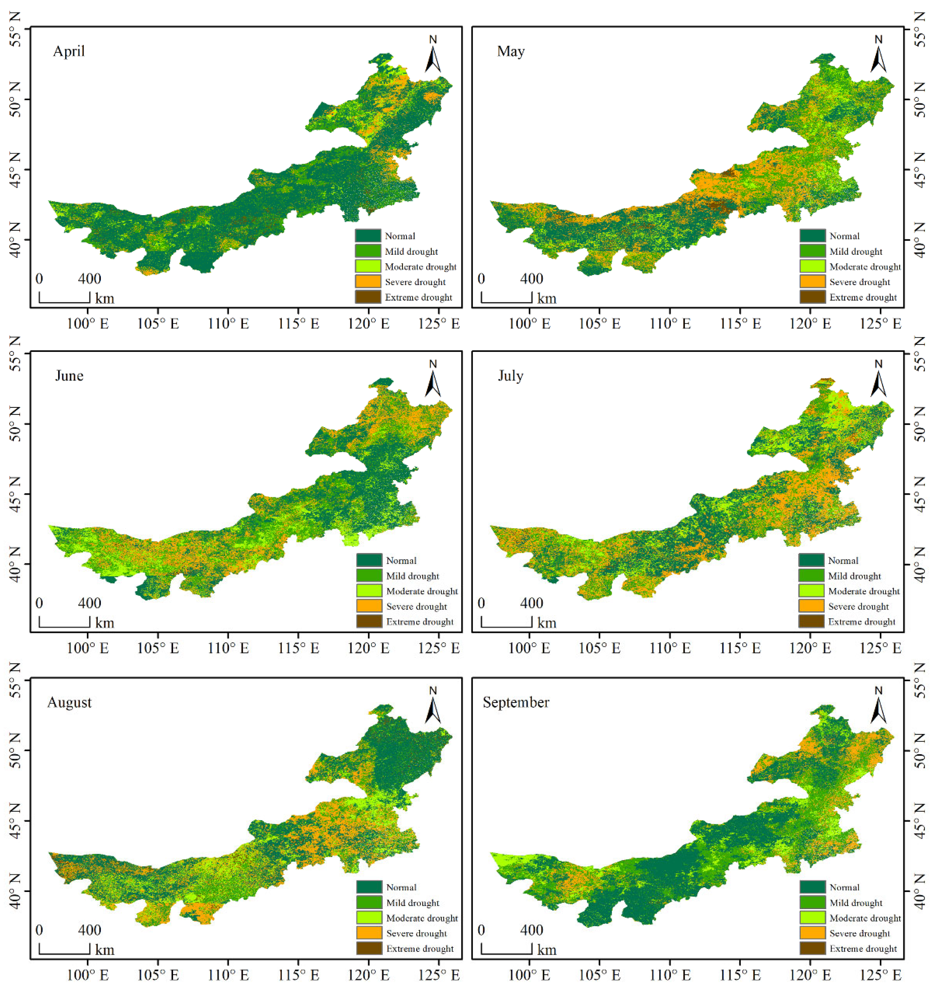
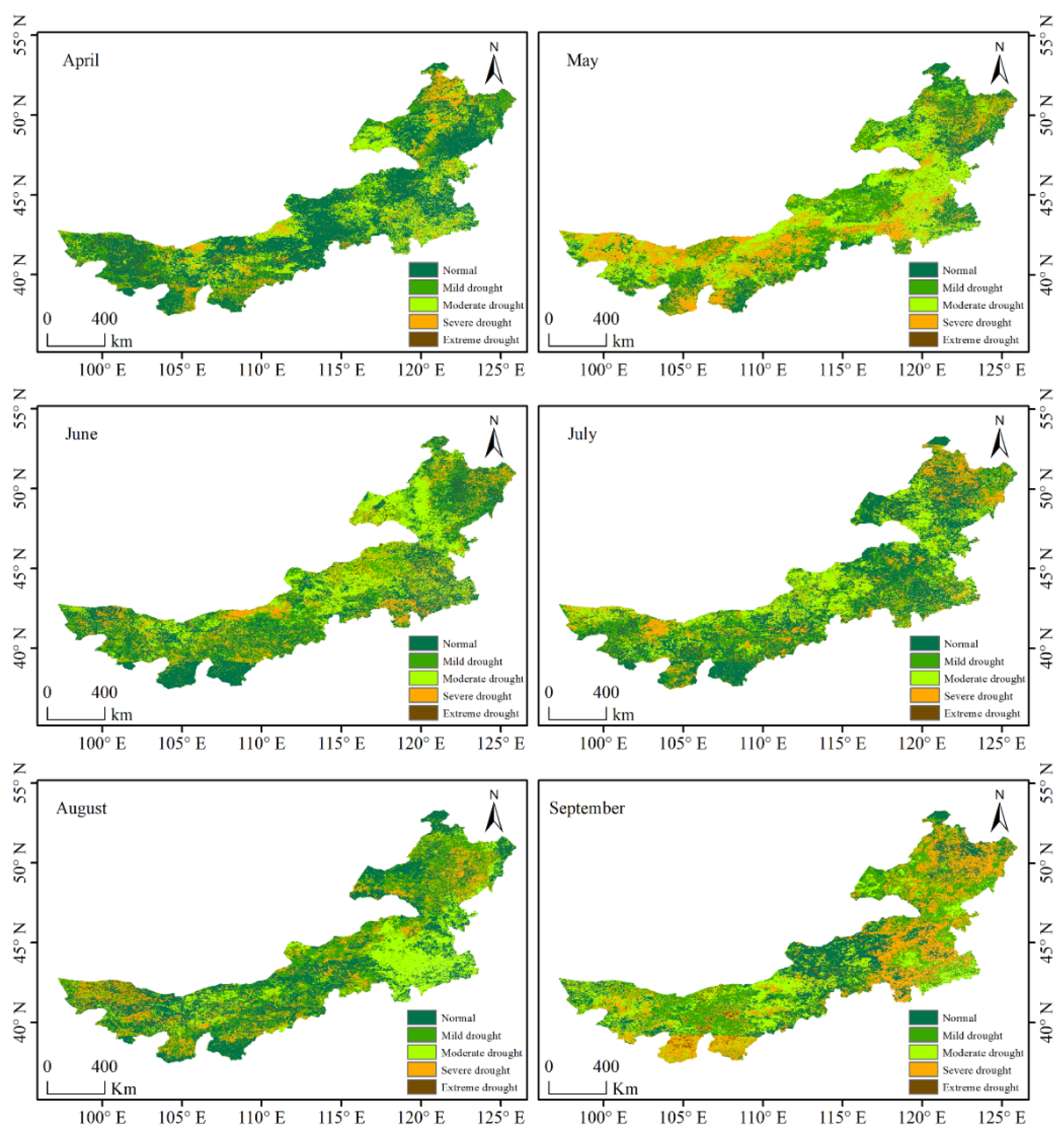
- In this study, drought events from April to September in Inner Mongolia were monitored in wet years, normal years, and dry years, using the constructed model. The monitoring results of the model constructed in this study were in accordance with the actual drought occurrence degree and spatial distribution. Therefore, the model constructed in this study has a strong monitoring capability for grassland drought disasters.
Author Contributions
Funding
Data Availability Statement
Conflicts of Interest
References
- Orimoloye, I.R.; Belle, J.A.; Ololade, O.O. Drought disaster monitoring using MODIS derived index for drought years: A space-based information for ecosystems and environmental conservation. J. Environ. Manag. 2021, 284, 112028. [Google Scholar] [CrossRef] [Scilit] [PubMed]
- Wang, Q.; Liu, Y.Y.; Zhang, Y.Z.; Tong, L.J.; Sun, Z. Assessment of Spatial Agglomeration of Agricultural Drought Disaster in China from 1978 to 2016. Sci. Rep. 2019, 9, 14393. [Google Scholar] [CrossRef] [Scilit] [PubMed]
- Othman, D.B.; Abida, H. Monitoring and mapping of drought in a semi-arid region: Case of the Merguellil watershed, central Tunisia. Environ. Monit. Assess. 2022, 194, 287. [Google Scholar] [CrossRef] [Scilit] [PubMed]
- Zhang, Y.; Wang, Q.; Wang, Z.; Yang, Y.; Li, J. Impact of human activities and climate change on the grassland dynamics under different regime policies in the Mongolian Plateau. Sci. Total Environ. 2019, 698, 134304. [Google Scholar] [CrossRef] [Scilit]
- Balti, H.; Abbes, A.B.; Mellouli, N.; Farah, I.R.; Lamolle, M. A review of drought monitoring with big data: Issues, methods, challenges and research directions. Ecol. Inform. 2020, 60, 101136. [Google Scholar] [CrossRef] [Scilit]
- Azam, M.; Hunjra, A.I.; Bouri, E.; Tan, Y.; Al-Faryan, M. Impact of institutional quality on sustainable development: Evidence from developing countries. J. Environ. Manag. 2021, 298, 113465. [Google Scholar] [CrossRef] [Scilit]
- Askarimarnani, S.S.; Kiem, A.S.; Twomey, C.R. Comparing the performance of drought indicators in Australia from 1900 to 2018. Int. J. Climatol. 2020, 41, E912–E934. [Google Scholar] [CrossRef] [Scilit]
- Mukherjee, S.; Mishra, A.; Trenberth, K.E. Climate Change and Drought: A Perspective on Drought Indices. Curr. Clim. Chang. Rep. 2018, 4, 145–163. [Google Scholar] [CrossRef] [Scilit]
- Zhou, J.; Chen, X.; Xu, C.; Wu, P. Assessing Socioeconomic Drought Based on a Standardized Supply and Demand Water Index. Water Resour. Manag. 2022, 36, 1937–1953. [Google Scholar] [CrossRef] [Scilit]
- Benedict, T.D.; Brown, J.F.; Boyte, S.P.; Howard, D.M.; Evenson, K.A. Exploring VIIRS Continuity with MODIS in an Expedited Capability for Monitoring Drought-Related Vegetation Conditions. Remote Sens. 2021, 13, 1210. [Google Scholar] [CrossRef] [Scilit]
- Chen, C. Review of Drought Disaster Evaluation. Prog. Geogr. 2011, 30, 891–898. [Google Scholar]
- Svoboda, M.; Fuchs, B.; Darani, S.M.M. Handbook of Drought Indicators and Indices; WMO: Geneva, Switzerland, 2016. [Google Scholar]
- Qi, L.A.; Sha, Z.A.; Hz, C.; Yun, B.A.; Jza, B. Monitoring drought using composite drought indices based on remote sensing. Sci. Total Environ. 2020, 711, 134585. [Google Scholar]
- Rhee, J.; Im, J.; Carbone, G.J. Monitoring agricultural drought for arid and humid regions using multi-sensor remote sensing data. Remote Sens. Environ. 2010, 114, 2875–2887. [Google Scholar] [CrossRef] [Scilit]
- Shen, R.; Huang, A.; Li, B.; Guo, J. Construction of a drought monitoring model using deep learning based on multi-source remote sensing data. Int. J. Appl. Earth Obs. Geoinf. 2019, 79, 48–57. [Google Scholar] [CrossRef] [Scilit]
- Hao, Z.; Aghakouchak, A. Multivariate Standardized Drought Index: A parametric multi-index model. Adv. Water Resour. 2013, 57, 12–18. [Google Scholar] [CrossRef] [Scilit]
- Kim, S.W.; Jung, D.; Choung, Y.J. Development of a Multiple Linear Regression Model for Meteorological Drought Index Estimation Based on Landsat Satellite Imagery. Water 2020, 13, 3393. [Google Scholar] [CrossRef] [Scilit]
- Lee, Y. Development of Integrated Crop Drought Index by Combining Rainfall, Land Surface Temperature, Evapotranspiration, Soil Moisture, and Vegetation Index for Agricultural Drought Monitoring. Remote Sens. 2021, 13, 1778. [Google Scholar] [CrossRef] [Scilit]
- Breiman, L. Random forest. Mach. Learn. 2001, 45, 5–32. [Google Scholar] [CrossRef] [Scilit]
- Svetnik, V. Random forest: A classification and regression tool for compound classification and QSAR modeling. J. Chem. Inf. Comput. Sci. 2003, 43, 1947–1958. [Google Scholar] [CrossRef] [Scilit]
- Ham, J.; Chen, Y.; Crawford, M.M.; Ghosh, J. Investigation of the random forest framework for classification of hyperspectral data. IEEE Trans. Geosci. Remote Sens. 2005, 43, 492–501. [Google Scholar] [CrossRef] [Scilit]
- Rodriguez-Galiano, V.F.; Ghimire, B.; Rogan, J.; Chica-Olmo, M.; Rigol-Sanchez, J.P. An assessment of the effectiveness of a random forest classifier for land-cover classification. ISPRS J. Photogramm. Remote Sens. 2012, 67, 93–104. [Google Scholar] [CrossRef] [Scilit]
- Shimizu, K.; Ota, T.; Mizoue, N.; Yoshida, S. A comprehensive evaluation of disturbance agent classification approaches: Strengths of ensemble classification, multiple indices, spatio-temporal variables, and direct prediction. ISPRS J. Photogramm. Remote Sens. 2019, 158, 99–112. [Google Scholar] [CrossRef] [Scilit]
- Speiser, J.L.; Miller, M.E.; Tooze, J.; Ip, E. A comparison of random forest variable selection methods for classification prediction modeling. Expert Syst. Appl. 2019, 134, 93–101. [Google Scholar] [CrossRef] [Scilit]
- Fang, A.; Bao, M.; Chen, W.; Dong, J. Assessment of Surface Ecological Quality of Grassland Mining Area and Identification of Its Impact Range. Nat. Resour. Res. 2021, 30, 3819–3837. [Google Scholar] [CrossRef] [Scilit]
- Van Der Heijden, M.G.; Klironomos, J.N.; Ursic, M.; Moutoglis, P.; Streitwolf-Engel, R.; Boller, T.; Wiemken, A.; Sanders, I.R. Mycorrhizal fungal diversity determines plant biodiversity, ecosystem variability and productivity. Nature 1998, 396, 69–72. [Google Scholar] [CrossRef] [Scilit]
- Wang, Q.; Liu, X.; Wang, Z.; Zhao, L.; Zhang, Q.P. Time scale selection and periodicity analysis of grassland drought monitoring index in Inner Mongolia. Glob. Ecol. Conserv. 2022, 36, e02138. [Google Scholar] [CrossRef] [Scilit]
- Zhao, G.; Han, Y.; Liu, M.; Zhao, S.; Liu, W. Characteristics of temporal and spatial variations of extreme temperature events in Inner Mongolia during 1951–2014. J. Arid Land Resour. Environ. 2017, 31, 110–116. [Google Scholar]
- Yang, H.; Zhou, W.; Huang, L. Temporal and spatial patterns of grassland coverage and responses to hydrothermic factors in Inner Mongolia from 2001 to 2016. Pratacultural Sci. 2019, 36, 359–367. [Google Scholar]
- Ai-Hua, M.; Yue, D.P.; Zhao, J.B.; Qian, H.U. Spatiotemporal Variation and Effect of Extreme Precipitation in Inner Mongolia in Recent 60 Years. Arid Zone Res. 2020, 37, 74–85. [Google Scholar]
- Zarei, A.R.; Moghimi, M.M. Modified version for SPEI to evaluate and modeling the agricultural drought severity. Int. J. Biometeorol. 2019, 63, 911–925. [Google Scholar] [CrossRef] [Scilit]
- Vicent Serrano, S.M.; Beguería, S.; López Moreno, J.I. A Multiscalar Drought Index Sensitive to Global Warming: The Standardized Precipitation Evapotranspiration Index. J. Clim. 2010, 23, 1696–1718. [Google Scholar] [CrossRef] [Scilit]
- Singh, R.P.; Roy, S.; Kogan, F. Vegetation and temperature condition indices from NOAA AVHRR data for drought monitoring over India. Int. J. Remote Sens. 2003, 24, 4393–4402. [Google Scholar] [CrossRef] [Scilit]
- Ba, R.; Song, W.; Lovallo, M.; Zhang, H.; Telesca, L. Informational analysis of MODIS NDVI and EVI time series of sites affected and unaffected by wildfires. Phys. A Stat. Mech. Appl. 2022, 604, 127911. [Google Scholar] [CrossRef] [Scilit]
- Patasaraiya, M.K.; Devi, R.M.; Sinha, B.; Bisaria, J.; Saran, S.; Jaiswal, R. Understanding the Resilience of Sal and Teak Forests to Climate Variability Using NDVI and EVI Time Series. For. Sci. 2021, 67, 192–204. [Google Scholar] [CrossRef] [Scilit]
- Enebish, B.; Dashkhuu, D.; Renchin, M.; Russell, M.; Singh, P. Impact of Climate on the NDVI of Northern Mongolia. J. Indian Soc. Remote Sens. 2019, 48, 333–340. [Google Scholar] [CrossRef] [Scilit]
- Qin, Y.; Zhang, T.-B.; Yi, G.-H.; Wei, P.-T.; Yang, D. Remote sensing monitoring and analysis of influencing factors of drought in Inner Mongolia growing season since 2000. J. Nat. Resour. 2021, 36, 459–475. [Google Scholar] [CrossRef] [Scilit]
- Kogan, F.N. Application of vegetation index and brightness temperature for drought detection. Adv. Space Res. 1995, 15, 91–100. [Google Scholar] [CrossRef] [Scilit]
- Wang, S.; Wang, S.; Feng, J. Drought Events and Its causes in Autumn of 2012 in China. J. Arid Meteorol. 2012, 30, 660–666. [Google Scholar]
- Duan, H.; Wang, S.; Feng, J. Drought Events and Its Causes in 2012 in China. J. Arid Meteorol. 2013, 31, 220–229. [Google Scholar]
- Krellenberg, K.; Müller, A.; Schwarz, A.; Höfer, R.; Welz, J. Flood and heat hazards in the Metropolitan Region of Santiago de Chile and the socio-economics of exposure. Appl. Geogr. 2013, 38, 86–95. [Google Scholar] [CrossRef] [Scilit]
- Vorkauf, M.; Kahmen, A.; Krner, C.; Hiltbrunner, E. Flowering phenology in alpine grassland strongly responds to shifts in snowmelt but weakly to summer drought. Alp. Bot. 2021, 131, 73–88. [Google Scholar] [CrossRef] [Scilit]
- Wang, S.; Wang, S.; Feng, J. Drought Events and Its Causes in 2015 in China. J. Arid Meteorol. 2016, 34, 382–389. [Google Scholar]
- Zhang, Y.; Wang, S.; Feng, J. Drought Events and Its causes in Autumn of 2015 in China. J. Arid Meteorol. 2015, 33, 1050–1057. [Google Scholar]
- Wang, S.; Zhang, Y.; Feng, J. Drought Events and Its causes in Summer of 2015 in China. J. Arid Meteorol. 2015, 33, 888–893. [Google Scholar]
- Wang, S.; Wang, S.; Feng, J. Drought Events and Its causes in Autumn of 2017 in China. J. Arid Meteorol. 2017, 35, 1084–1089. [Google Scholar]
- Zhang, Y.; Zhang, L.; Wang, S.; Feng, J. Drought Events and Its causes in Summer of 2017 in China. J. Arid Meteorol. 2017, 33, 899–905. [Google Scholar]
- Zhang, Y.; Wang, S.; Feng, J. Drought Events and Its Causes in 2017 in China. J. Arid Meteorol. 2018, 036, 331–338. [Google Scholar]


| Data | Description | Source |
|---|---|---|
| Meteorological data | Monthly average temperature | National Meteorological Information Center (http://data.cma.cn/detail/dataCode/A.0012.0001.html) |
| Monthly maximum/minimum temperature | ||
| Precipitation data | ||
| Wind speed data at 2 m height | ||
| Station altitude/longitude | ||
| Sunshine hours (h) | ||
| MOD13A3 (1 km) | Moderate Resolution Imaging Spectroradiometer Enhanced vegetation index product | National Aeronautics and Space Administration (https://search.earthdata.nasa.gov/search?q=GPM) |
| GPM-3IMERG (0.1° × 0.1°) | Monthly averaged grid precipitation dataset (mm/h) | |
| MOD11A2 (1 km) | Surface temperature product | |
| SRTM3 V4.1 (90 m) | Shuttle Radar Topography Mission Digital Elevation Model | (http://srtm.csi.cgiar.org/srtmdata/) |
| SPEI Value Class | Situation Classification |
|---|---|
| ≤−2.0 | Extreme drought |
| −2.0 < SPEI ≤ −1.5 | Severe drought |
| −1.5 < SPEI ≤ −1.0 | Moderate drought |
| −1.0 < SPEI ≤ −0.5 | Mild drought |
| −0.5 < SPEI ≤ 0.5 | Normal or wet spell |
| Standard Deviation (Std) | Root Mean Square Error (RMSE) | Correlation Coefficient (R) | |
|---|---|---|---|
| Training set | 0.00364 | 0.18855 | 0.9706 ** |
| Testing set | 0.01299 | 0.43636 | 0.6387 ** |
Publisher’s Note: MDPI stays neutral with regard to jurisdictional claims in published maps and institutional affiliations. |
© 2022 by the authors. Licensee MDPI, Basel, Switzerland. This article is an open access article distributed under the terms and conditions of the Creative Commons Attribution (CC BY) license (https://creativecommons.org/licenses/by/4.0/).
Share and Cite
Wang, Q.; Zhao, L.; Wang, M.; Wu, J.; Zhou, W.; Zhang, Q.; Deng, M. A Random Forest Model for Drought: Monitoring and Validation for Grassland Drought Based on Multi-Source Remote Sensing Data. Remote Sens. 2022, 14, 4981. https://doi.org/10.3390/rs14194981
Wang Q, Zhao L, Wang M, Wu J, Zhou W, Zhang Q, Deng M. A Random Forest Model for Drought: Monitoring and Validation for Grassland Drought Based on Multi-Source Remote Sensing Data. Remote Sensing. 2022; 14(19):4981. https://doi.org/10.3390/rs14194981
Chicago/Turabian StyleWang, Qian, Lin Zhao, Mali Wang, Jinjia Wu, Wei Zhou, Qipeng Zhang, and Meie Deng. 2022. "A Random Forest Model for Drought: Monitoring and Validation for Grassland Drought Based on Multi-Source Remote Sensing Data" Remote Sensing 14, no. 19: 4981. https://doi.org/10.3390/rs14194981
APA StyleWang, Q., Zhao, L., Wang, M., Wu, J., Zhou, W., Zhang, Q., & Deng, M. (2022). A Random Forest Model for Drought: Monitoring and Validation for Grassland Drought Based on Multi-Source Remote Sensing Data. Remote Sensing, 14(19), 4981. https://doi.org/10.3390/rs14194981