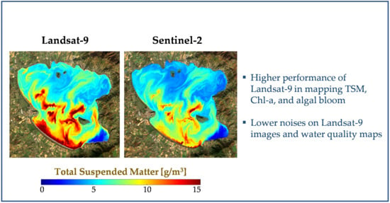
Water Quality Retrieval from Landsat-9 (OLI-2) Imagery and Comparison to Sentinel-2
Abstract
:1. Introduction
2. Case Studies and Datasets
3. Methods
3.1. Physics-Based Model and Parametrization
3.2. Neural Network-Based Regression Model
3.3. Validation and Consistency Analysis
3.4. Image-Based SNR Estimation
4. Results and Discussion
4.1. Physics-Based Inversion in Italian lakes
4.2. NN-Based Chl-a Retrieval in San Francisco Bay
4.3. Image-Based SNR Estimation
5. Conclusions
Author Contributions
Funding
Data Availability Statement
Acknowledgments
Conflicts of Interest
References
- Carpenter, D.J.; Carpenter, S.M. Modeling inland water quality using Landsat data. Remote Sens. Environ. 1983, 13, 345–352. [Google Scholar] [CrossRef]
- Munday, J.C.; Alföldi, T.T. LANDSAT test of diffuse reflectance models for aquatic suspended solids measurement. Remote Sens. Environ. 1979, 8, 169–183. [Google Scholar] [CrossRef]
- Gerace, A.D.; Schott, J.R.; Nevins, R. Increased potential to monitor water quality in the near-shore environment with Landsat’s next-generation satellite. J. Appl. Remote Sens. 2013, 7, 1–19. [Google Scholar] [CrossRef]
- Markogianni, V.; Kalivas, D.; Petropoulos, G.; Dimitriou, E. An Appraisal of the Potential of Landsat 8 in Estimating Chlorophyll-a, Ammonium Concentrations and Other Water Quality Indicators. Remote Sens. 2018, 10, 1018. [Google Scholar] [CrossRef]
- Jorge, D.S.F.; Barbosa, C.C.F.; De Carvalho, L.A.S.; Affonso, A.G.; Lobo, F.D.L.; Novo, E.M.L.D.M. SNR (Signal-To-Noise Ratio) Impact on Water Constituent Retrieval from Simulated Images of Optically Complex Amazon Lakes. Remote Sens. 2017, 9, 644. [Google Scholar] [CrossRef]
- Sent, G.; Biguino, B.; Favareto, L.; Cruz, J.; Sá, C.; Dogliotti, A.I.; Palma, C.; Brotas, V.; Brito, A.C. Deriving Water Quality Parameters Using Sentinel-2 Imagery: A Case Study in the Sado Estuary, Portugal. Remote Sens. 2021, 13, 1043. [Google Scholar] [CrossRef]
- Toming, K.; Kutser, T.; Laas, A.; Sepp, M.; Paavel, B.; Nõges, T. First Experiences in Mapping Lake Water Quality Parameters with Sentinel-2 MSI Imagery. Remote Sens. 2016, 8, 640. [Google Scholar] [CrossRef]
- Ritchie, J.C.; Zimba, P.V.; Everitt, J.H. Remote Sensing Techniques to Assess Water Quality. Photogramm. Eng. Remote Sens. 2003, 69, 695–704. [Google Scholar] [CrossRef]
- Caballero, I.; Fernández, R.; Escalante, O.M.; Mamán, L.; Navarro, G. New capabilities of Sentinel-2A/B satellites combined with in situ data for monitoring small harmful algal blooms in complex coastal waters. Sci. Rep. 2020, 10, 8743. [Google Scholar] [CrossRef]
- Binding, C.E.; Greenberg, T.A.; McCullough, G.; Watson, S.B.; Page, E. An analysis of satellite-derived chlorophyll and algal bloom indices on Lake Winnipeg. J. Great Lakes Res. 2018, 44, 436–446. [Google Scholar] [CrossRef]
- Rodrigues, T.; Mishra, D.R.; Alcantara, E.; Watanabe, F.; Rotta, L.; Imai, N.N. Retrieving Total Suspended Matter in Tropical Reservoirs Within a Cascade System with Widely Differing Optical Properties. IEEE J. Sel. Top. Appl. Earth Obs. Remote Sens. 2017, 10, 5495–5512. [Google Scholar] [CrossRef]
- Soomets, T.; Uudeberg, K.; Jakovels, D.; Brauns, A.; Zagars, M.; Kutser, T. Validation and comparison of water quality products in baltic lakes using sentinel-2 msi and sentinel-3 OLCI data. Sensors 2020, 20, 742. [Google Scholar] [CrossRef]
- Giardino, C.; Bresciani, M.; Braga, F.; Cazzaniga, I.; De Keukelaere, L.; Knaeps, E.; Brando, V.E. Chapter 5—Bio-optical Modeling of Total Suspended Solids. In Bio-Optical Modeling and Remote Sensing of Inland Water; Mishra, D.R., Ogashawara, I., Gitelson, A.A., Eds.; Elsevier: Amsterdam, The Netherlands, 2017; pp. 129–156. ISBN 978-0-12-804644-9. [Google Scholar]
- Odermatt, D.; Gitelson, A.; Brando, V.E.; Schaepman, M. Review of constituent retrieval in optically deep and complex waters from satellite imagery. Remote Sens. Environ. 2012, 118, 116–126. [Google Scholar] [CrossRef]
- Niroumand-Jadidi, M.; Bovolo, F.; Bruzzone, L.; Gege, P. Inter-Comparison of Methods for Chlorophyll-a Retrieval: Sentinel-2 Time-Series Analysis in Italian Lakes. Remote Sens. 2021, 13, 2381. [Google Scholar] [CrossRef]
- Niroumand-Jadidi, M.; Bovolo, F.; Bruzzone, L. Novel Spectra-Derived Features for Empirical Retrieval of Water Quality Parameters: Demonstrations for OLI, MSI, and OLCI Sensors. IEEE Trans. Geosci. Remote Sens. 2019, 57, 10285–10300. [Google Scholar] [CrossRef]
- Hafeez, S.; Wong, M.S.; Ho, H.C.; Nazeer, M.; Nichol, J.; Abbas, S.; Tang, D.; Lee, K.H.; Pun, L. Comparison of Machine Learning Algorithms for Retrieval of Water Quality Indicators in Case-II Waters: A Case Study of Hong Kong. Remote Sens. 2019, 11, 617. [Google Scholar] [CrossRef]
- Niroumand-Jadidi, M.; Bovolo, F. Temporally Transferable Machine Learning Model for Total Suspended Matter Retrieval from Sentinel-2. ISPRS Ann. Photogramm. Remote Sens. Spat. Inf. Sci. 2022, 3, 339–345. [Google Scholar] [CrossRef]
- Niroumand-Jadidi, M.; Bovolo, F.; Bruzzone, L.; Gege, P. Physics-based Bathymetry and Water Quality Retrieval Using PlanetScope Imagery: Impacts of 2020 COVID-19 Lockdown and 2019 Extreme Flood in the Venice Lagoon. Remote Sens. 2020, 12, 2381. [Google Scholar] [CrossRef]
- Niroumand-Jadidi, M.; Bovolo, F.; Bruzzone, L. Water Quality Retrieval from PRISMA Hyperspectral Images: First Experience in a Turbid Lake and Comparison with Sentinel-2. Remote Sens. 2020, 12, 3984. [Google Scholar] [CrossRef]
- Mobley, C.D. Light and Water: Radiative Transfer in Natural Waters; Academic Press: Cambridge, MA, USA, 1994; ISBN 9780125027502. [Google Scholar]
- Gege, P. The water color simulator WASI: An integrating software tool for analysis and simulation of optical in situ spectra. Comput. Geosci. 2004, 30, 523–532. [Google Scholar] [CrossRef]
- Brockmann, C.; Doerffer, R.; Peters, M.; Stelzer, K.; Embacher, S.; Ruescas, A. Evolution of the C2RCC neural network for Sentinel 2 and 3 for the retrieval of ocean colour products in normal and extreme optically complex waters. In Proceedings of the ESA Living Planet, Prague, Czech Republic, 9–13 May 2016. [Google Scholar]
- Giardino, C.; Candiani, G.; Bresciani, M.; Lee, Z.; Gagliano, S.; Pepe, M. BOMBER: A tool for estimating water quality and bottom properties from remote sensing images. Comput. Geosci. 2012, 45, 313–318. [Google Scholar] [CrossRef]
- Gege, P. WASI-2D: A software tool for regionally optimized analysis of imaging spectrometer data from deep and shallow waters. Comput. Geosci. 2014, 62, 208–215. [Google Scholar] [CrossRef]
- Bresciani, M.; Giardino, C.; Fabbretto, A.; Pellegrino, A.; Mangano, S.; Free, G.; Pinardi, M. Application of New Hyperspectral Sensors in the Remote Sensing of Aquatic Ecosystem Health: Exploiting PRISMA and DESIS for Four Italian Lakes. Resources 2022, 11, 8. [Google Scholar] [CrossRef]
- Free, G.; Bresciani, M.; Pinardi, M.; Peters, S.; Laanen, M.; Padula, R.; Cingolani, A.; Charavgis, F.; Giardino, C. Shorter blooms expected with longer warm periods under climate change: An example from a shallow meso-eutrophic Mediterranean lake. Hydrobiologia 2022. [Google Scholar] [CrossRef]
- Eleveld, M.A.; Ruescas, A.B.; Hommersom, A.; Moore, T.S.; Peters, S.W.M.; Brockmann, C. An Optical Classification Tool for Global Lake Waters. Remote Sens. 2017, 9, 420. [Google Scholar] [CrossRef]
- Giardino, C.; Bresciani, M.; Stroppiana, D.; Oggioni, A.; Morabito, G. Optical remote sensing of lakes: An overview on Lake Maggiore. J. Limnol. 2013, 73, 817. [Google Scholar] [CrossRef]
- Chirico, N.; António, D.C.; Pozzoli, L.; Marinov, D.; Malagó, A.; Sanseverino, I.; Beghi, A.; Genoni, P.; Dobricic, S.; Lettieri, T. Cyanobacterial Blooms in Lake Varese: Analysis and Characterization over Ten Years of Observations. Water 2020, 12, 675. [Google Scholar] [CrossRef]
- Bresciani, M.; Giardino, C.; Lauceri, R.; Matta, E.; Cazzaniga, I.; Pinardi, M.; Lami, A.; Austoni, M.; Viaggiu, E.; Congestri, R.; et al. Earth observation for monitoring and mapping of cyanobacteria blooms. Case studies on five Italian lakes. J. Limnol. 2016, 76, 1565. [Google Scholar] [CrossRef]
- Pinardi, M.; Bresciani, M.; Villa, P.; Cazzaniga, I.; Laini, A.; Tóth, V.; Fadel, A.; Austoni, M.; Lami, A.; Giardino, C. Spatial and temporal dynamics of primary producers in shallow lakes as seen from space: Intra-annual observations from Sentinel-2A. Limnologica 2018, 72, 32–43. [Google Scholar] [CrossRef]
- Taylor, N.C.; Kudela, R.M. Spatial Variability of Suspended Sediments in San Francisco Bay, California. Remote Sens. 2021, 13, 4625. [Google Scholar] [CrossRef]
- Schraga, T.S.; Cloern, J.E. Water quality measurements in San Francisco Bay by the U.S. Geological Survey, 1969–2015. Sci. Data 2017, 4, 170098. [Google Scholar] [CrossRef] [PubMed]
- APAT Metodi Analitici per le Acque. Available online: https://www.isprambiente.gov.it/it/pubblicazioni/manuali-e-linee-guida/metodi-analitici-per-le-acque (accessed on 4 November 2020).
- Strömbeck, N.; Pierson, D.C. The effects of variability in the inherent optical properties on estimations of chlorophyll a by remote sensing in Swedish freshwaters. Sci. Total Environ. 2001, 268, 123–137. [Google Scholar] [CrossRef]
- Bresciani, M.; Pinardi, M.; Free, G.; Luciani, G.; Ghebrehiwot, S.; Laanen, M.; Peters, S.; Della Bella, V.; Padula, R.; Giardino, C. The Use of Multisource Optical Sensors to Study Phytoplankton Spatio-Temporal Variation in a Shallow Turbid Lake. Water 2020, 12, 284. [Google Scholar] [CrossRef]
- Tiberti, R.; Caroni, R.; Cannata, M.; Lami, A.; Manca, D.; Strigaro, D.; Rogora, M. Automated high frequency monitoring of Lake Maggiore through in situ sensors: System design, field test and data quality control. J. Limnol. 2021, 80, 2011. [Google Scholar] [CrossRef]
- Vanhellemont, Q. Adaptation of the dark spectrum fitting atmospheric correction for aquatic applications of the Landsat and Sentinel-2 archives. Remote Sens. Environ. 2019, 225, 175–192. [Google Scholar] [CrossRef]
- Vanhellemont, Q. Sensitivity analysis of the dark spectrum fitting atmospheric correction for metre- and decametre-scale satellite imagery using autonomous hyperspectral radiometry. Opt. Express 2020, 28, 29948–29965. [Google Scholar] [CrossRef] [PubMed]
- Pereira-Sandoval, M.; Ruescas, A.; Urrego, P.; Ruiz-Verdú, A.; Delegido, J.; Tenjo, C.; Soria-Perpinyà, X.; Vicente, E.; Soria, J.; Moreno, J. Evaluation of Atmospheric Correction Algorithms over Spanish Inland Waters for Sentinel-2 Multi Spectral Imagery Data. Remote Sens. 2019, 11, 1469. [Google Scholar] [CrossRef]
- Vanhellemont, Q.; Ruddick, K. Atmospheric correction of Sentinel-3/OLCI data for mapping of suspended particulate matter and chlorophyll-a concentration in Belgian turbid coastal waters. Remote Sens. Environ. 2021, 256, 112284. [Google Scholar] [CrossRef]
- Caballero, I.; Román, A.; Tovar-Sánchez, A.; Navarro, G. Water quality monitoring with Sentinel-2 and Landsat-8 satellites during the 2021 volcanic eruption in La Palma (Canary Islands). Sci. Total Environ. 2022, 822, 153433. [Google Scholar] [CrossRef]
- Kirk, J.T.O. Light and Photosynthesis in Aquatic Ecosystems, 2nd ed.; Cambridge University Press: Cambridge, UK, 1994. [Google Scholar]
- Maffione, R.A.; Dana, D.R. Instruments and methods for measuring the backward-scattering coefficient of ocean waters. Appl. Opt. 1997, 36, 6057–6067. [Google Scholar] [CrossRef]
- Dekker, A.G.; Peters, S.W.M. The use of the Thematic Mapper for the analysis of eutrophic lakes: A case study in the Netherlands. Int. J. Remote Sens. 1993, 14, 799–821. [Google Scholar] [CrossRef]
- Han, L.; Jordan, K.J. Estimating and mapping chlorophyll- a concentration in Pensacola Bay, Florida using Landsat ETM+ data. Int. J. Remote Sens. 2005, 26, 5245–5254. [Google Scholar] [CrossRef]
- Niroumand-Jadidi, M.; Legleiter, C.J.; Bovolo, F. Bathymetry retrieval from CubeSat image sequences with short time lags. Int. J. Appl. Earth Obs. Geoinf. 2022, 112, 102958. [Google Scholar] [CrossRef]
- Arlot, S.; Celisse, A. A survey of cross-validation procedures for model selection. Stat. Surv. 2010, 4, 40–79. [Google Scholar] [CrossRef]
- Seegers, B.N.; Stumpf, R.P.; Schaeffer, B.A.; Loftin, K.A.; Werdell, P.J. Performance metrics for the assessment of satellite data products: An ocean color case study. Opt. Express 2018, 26, 7404. [Google Scholar] [CrossRef]
- Gao, B.-C. An operational method for estimating signal to noise ratios from data acquired with imaging spectrometers. Remote Sens. Environ. 1993, 43, 23–33. [Google Scholar] [CrossRef]
- Niroumand-Jadidi, M.; Legleiter, C.J.; Bovolo, F. River Bathymetry Retrieval From Landsat-9 Images Based on Neural Networks and Comparison to SuperDove and Sentinel-2. IEEE J. Sel. Top. Appl. Earth Obs. Remote Sens. 2022, 15, 5250–5260. [Google Scholar] [CrossRef]
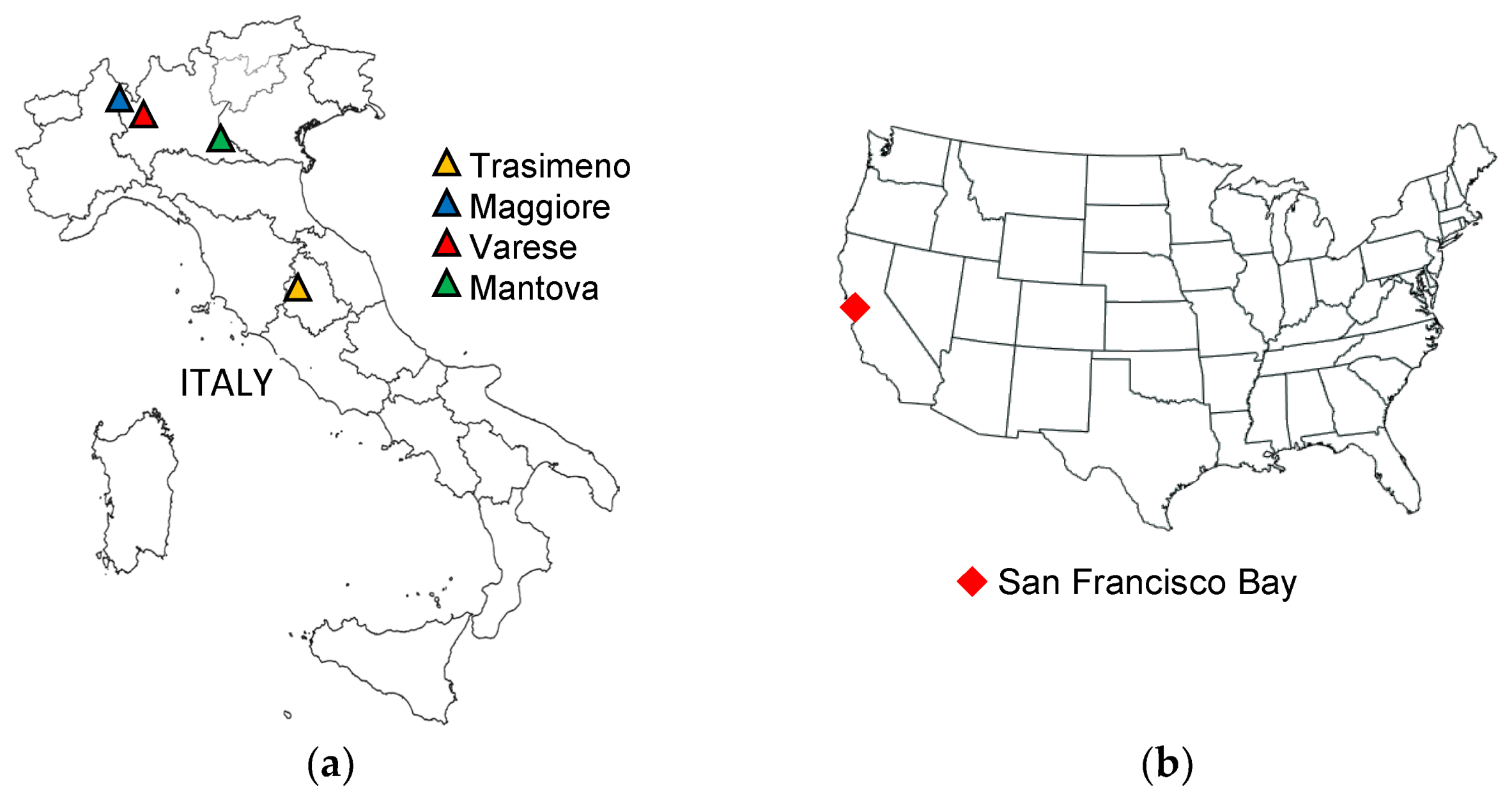
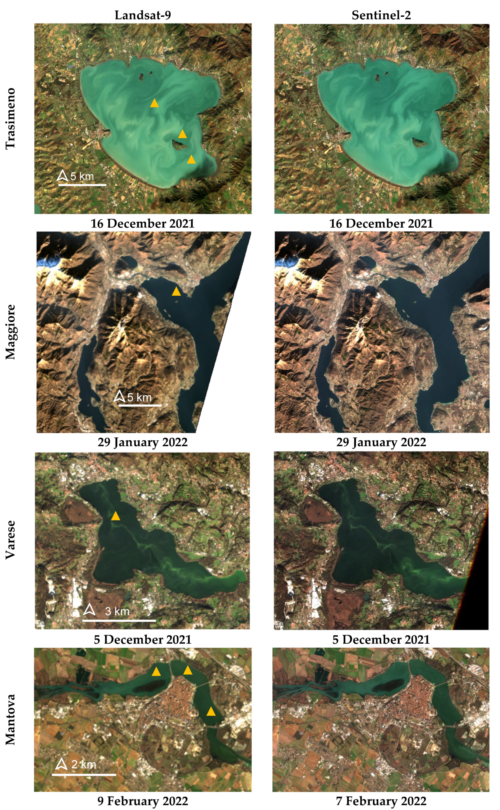
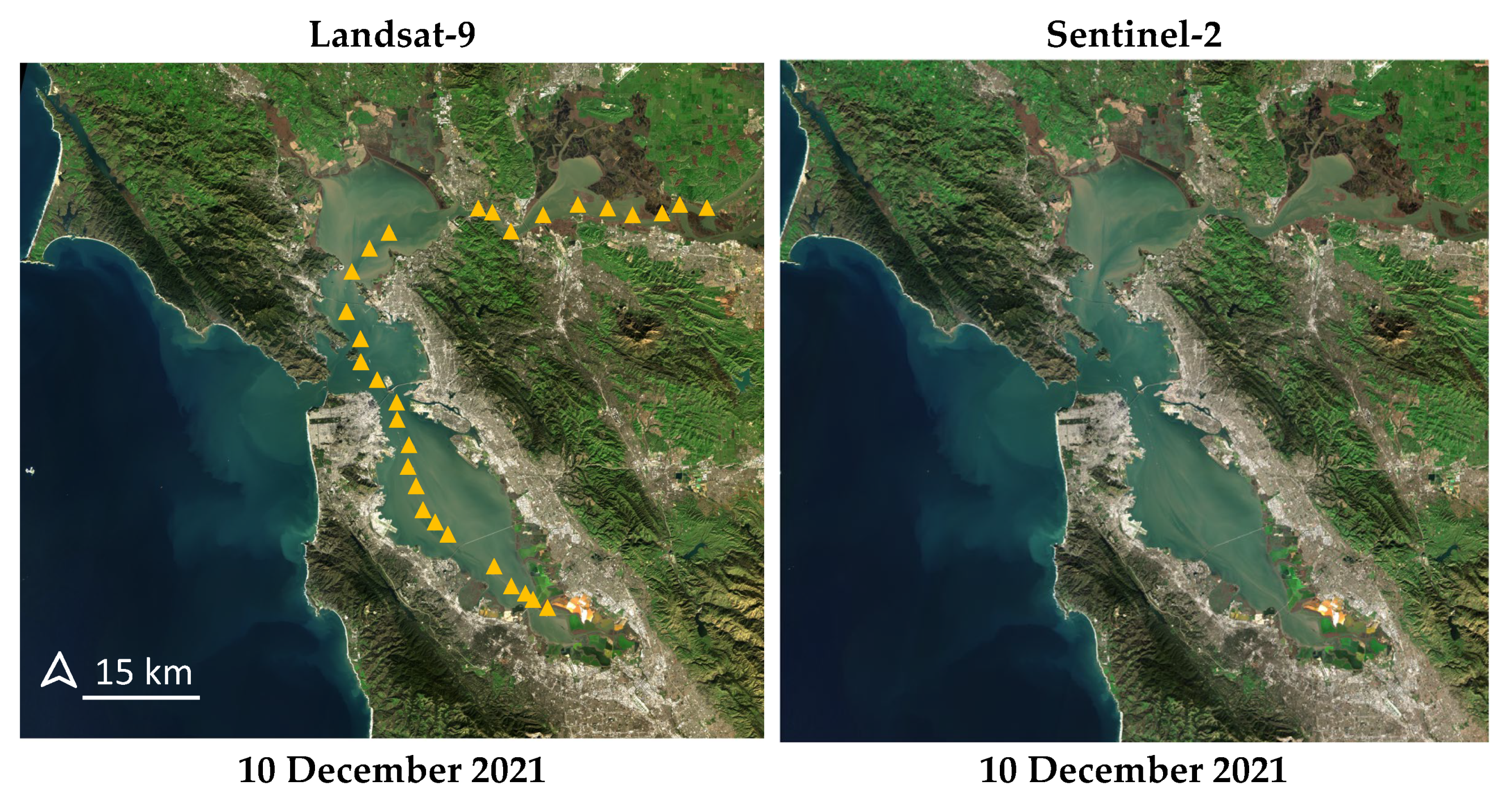
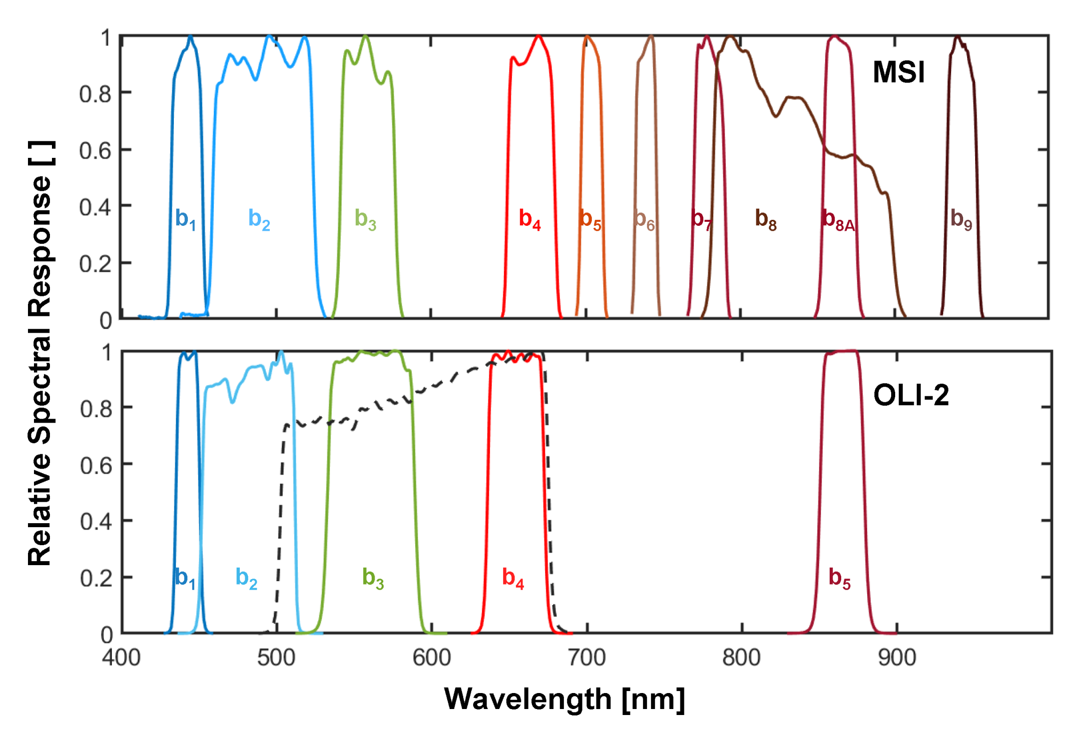
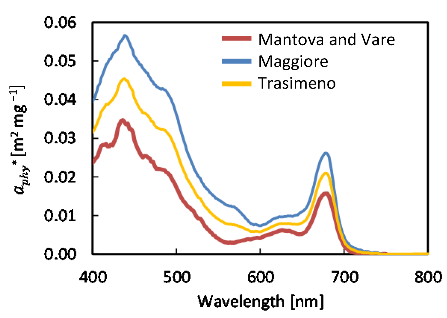

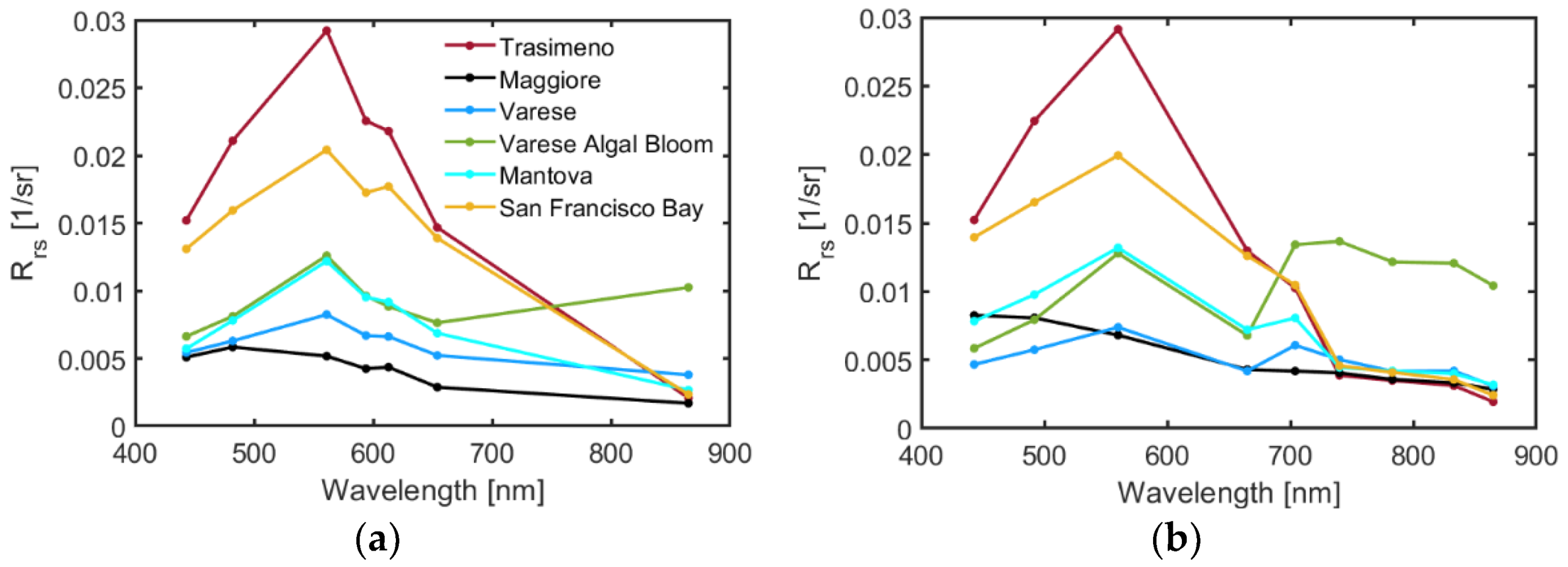
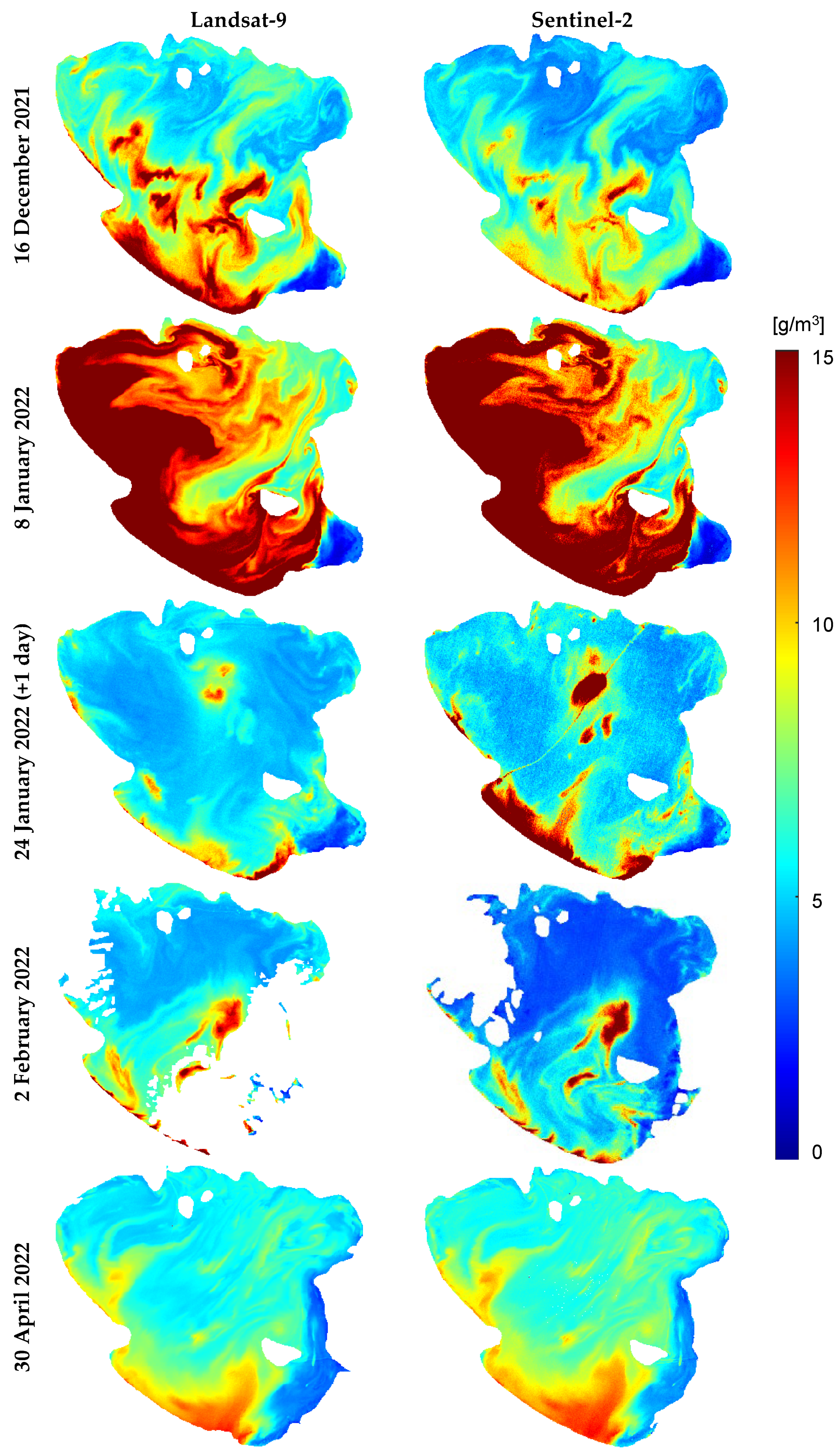
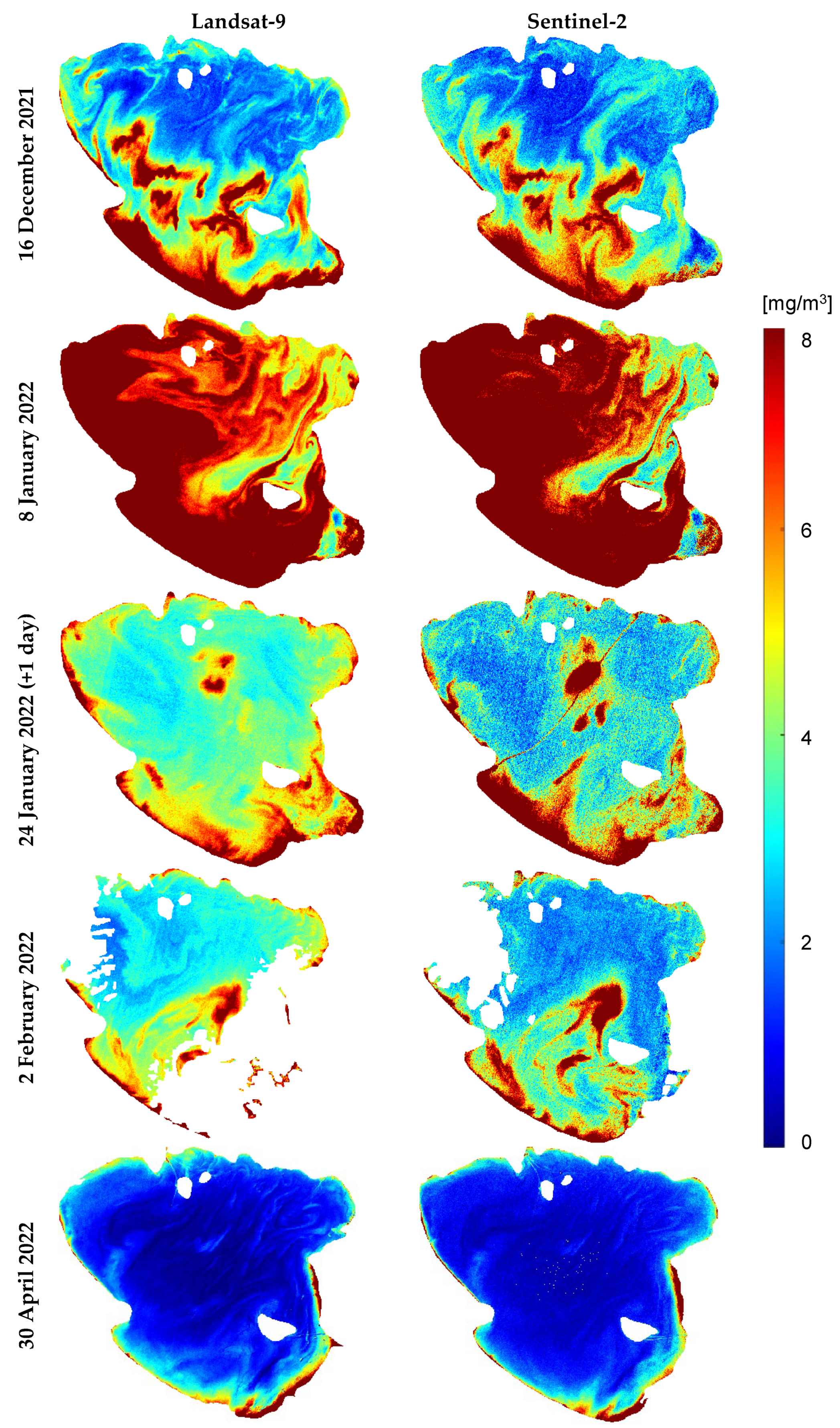



| Water Body | Site Descriptions | Landsat-9 Imagery (Sentinel-2 Overpass) | Number of In Situ Matchups |
|---|---|---|---|
| Trasimeno Lake | Surface area: 120.5 km2 Shallow (max depth ~6.3 m), turbid (Secchi depth ~1.1 m), and mesotrophic–eutrophic lake [26,27] | 16 December 2021 (same day) 8 January 2022 (same day) 24 January 2022 (+1 day) 2 February 2022 (same day) 30 April 2022 (same day) | 4 Chl-a 2 TSM |
| Maggiore Lake | Surface area ~212.5 km2, represents deep water up to 370 m, oligotrophic lake [28], Secchi depth ~10 m [29] | 29 January 2022 (same day) | 1 Chl-a 1 TSM |
| Varese Lake | Surface area ~14.8 km2, mean depth ~11 m; Secchi depth ~3 m [30]. A dimictic lake with a summer stratification from May to November and an inverse stratification in winter [31] | 5 December 2021 (same day) | 1 Chl-a |
| Mantova Lake | Surface area: 6.2 km2; mean depth ~3.5 m; a hypertrophic system composed of three fluvial lakes with low transparency (Secchi depth < 1 m in summer and high Chl-a concentration) [31,32] | 9 February 2022 (−2 days) | 3 Chl-a 3 TSM |
| San Francisco Bay | Surface area: ~1400 km2; most extensive estuary system on the west coast of North America, overall a shallow water body (<3 m in most parts) but also representing deep waters up to ~113 m, turbid with an average TSM of ~30 g/m3 for the past year [33,34] | 10 December 2021 (same day) | 34 Chl-a |
| Trasimeno | Maggiore | Varese and Mantova | |
|---|---|---|---|
| Spectral slope coefficient of CDOM absorption [1/nm] | 0.016 | 0.019 | 0.015 |
| Specific absorption of non-algal particles (NAP) at 440 nm [m2/g] | 0.2 | 0.05 | 0.3 |
| Spectral slope coefficient of NAP absorption [1/nm] | 0.013 | 0.011 | 0.009 |
| Backscattering exponent of TSM [−] | 0.65 | 0.76 | 0.8 |
| Specific backscattering coefficient of TSM at 555 nm [m2/g] | 0.0119 | 0.0071 | 0.0111 |
| R2 | RMSD | NRMSD% | Bias | MAE | ||
|---|---|---|---|---|---|---|
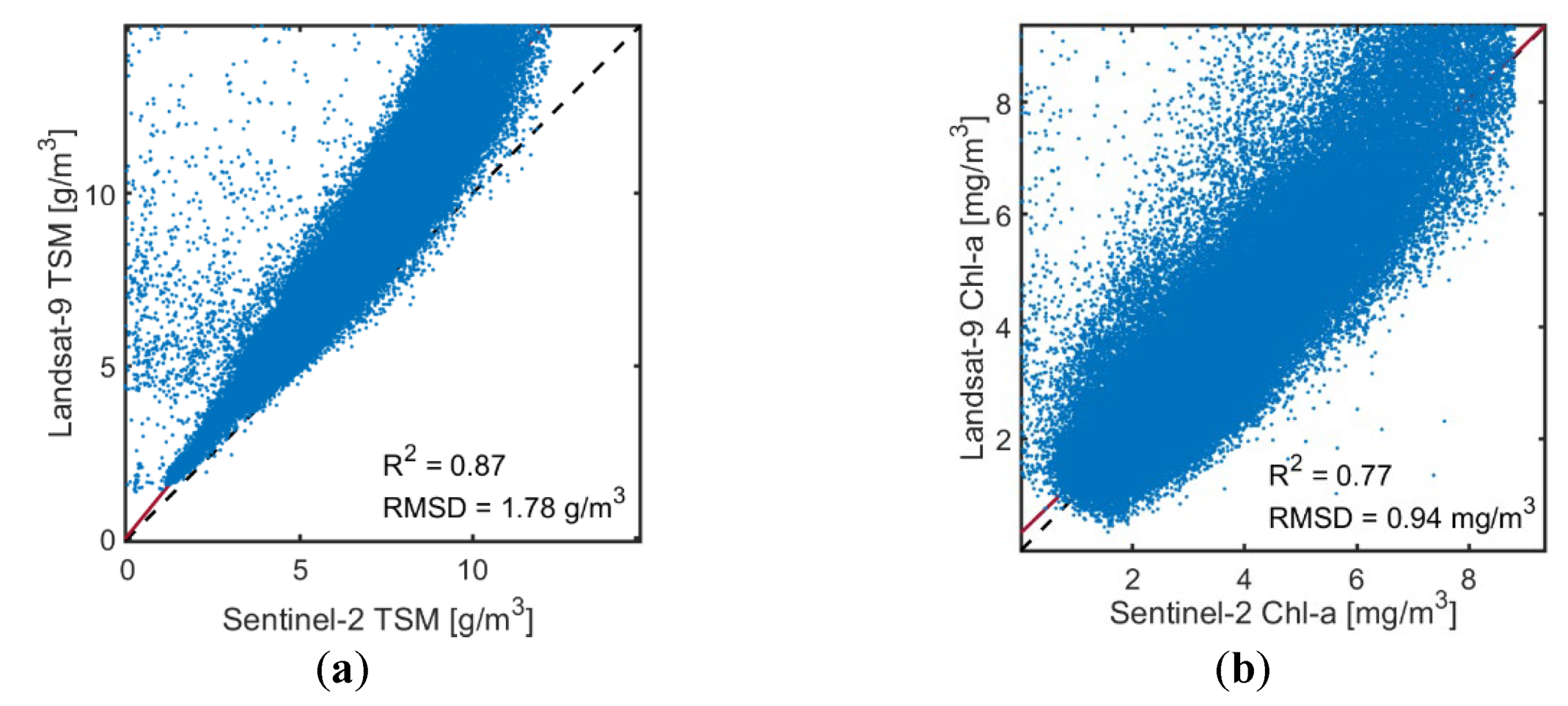
| Trasimeno 16 December 2021 | TSM | 0.87 | 1.78 g/m3 | 22 | 1.24 | 1.24 |
| Chl-a | 0.77 | 0.94 mg/m3 | 21 | 1.05 | 1.25 | |
| Trasimeno 8 January 2022 | TSM | 0.90 | 4.56 g/m3 | 20 | 0.92 | 1.18 |
| Chl-a | 0.92 | 5.63 mg/m3 | 38 | 0.79 | 1.36 | |
| Trasimeno 24 January 2022 | TSM | 0.31 | 1.03 g/m3 | 14 | 0.93 | 1.14 |
| Chl-a | 0.30 | 1.19 mg/m3 | 26 | 1.21 | 1.32 | |
| Trasimeno 2 February 2022 | TSM | 0.82 | 1.50 g/m3 | 25 | 1.40 | 1.41 |
| Chl-a | 0.59 | 0.93 mg/m3 | 24 | 1.27 | 1.31 | |
| Trasimeno 30 April 2022 | TSM | 0.97 | 0.66 g/m3 | 9 | 0.90 | 1.10 |
| Chl-a | 0.69 | 0.44 mg/m3 | 28 | 0.88 | 1.54 | |
| Maggiore | TSM | 0.33 | 0.16 g/m3 | 20 | 1.23 | 1.24 |
| Chl-a | 0.06 | 0.49 mg/m3 | 19 | 1.17 | 1.18 | |
| Mantova | TSM | 0.17 | 0.99 g/m3 | 19 | 0.86 | 1.18 |
| Varese | Chl-a | 0.13 | 61.7 mg/m3 | 55 | 0.40 | 2.52 |
| R2 | RMSE | NRMSE% | Bias | MAE | ||
|---|---|---|---|---|---|---|
| TSM | Landsat-9 | 0.89 | 0.77 g/m3 | 18 | 1.01 | 1.17 |
| Sentinel-2 | 0.71 | 1.20 g/m3 | 27 | 1.04 | 1.27 | |
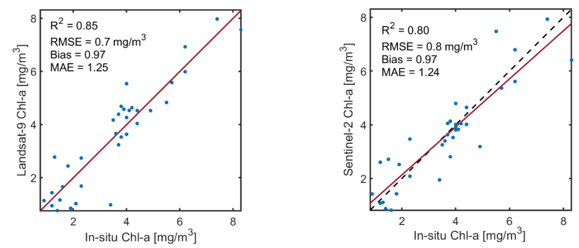
| Chl-a | Landsat-9 | 0.99 | 1.05 mg/m3 | 5 | 1.03 | 1.16 |
| Sentinel-2 | 0.97 | 12.7 mg/m3 | 55 | 1.01 | 1.27 |
Publisher’s Note: MDPI stays neutral with regard to jurisdictional claims in published maps and institutional affiliations. |
© 2022 by the authors. Licensee MDPI, Basel, Switzerland. This article is an open access article distributed under the terms and conditions of the Creative Commons Attribution (CC BY) license (https://creativecommons.org/licenses/by/4.0/).
Share and Cite
Niroumand-Jadidi, M.; Bovolo, F.; Bresciani, M.; Gege, P.; Giardino, C. Water Quality Retrieval from Landsat-9 (OLI-2) Imagery and Comparison to Sentinel-2. Remote Sens. 2022, 14, 4596. https://doi.org/10.3390/rs14184596
Niroumand-Jadidi M, Bovolo F, Bresciani M, Gege P, Giardino C. Water Quality Retrieval from Landsat-9 (OLI-2) Imagery and Comparison to Sentinel-2. Remote Sensing. 2022; 14(18):4596. https://doi.org/10.3390/rs14184596
Chicago/Turabian StyleNiroumand-Jadidi, Milad, Francesca Bovolo, Mariano Bresciani, Peter Gege, and Claudia Giardino. 2022. "Water Quality Retrieval from Landsat-9 (OLI-2) Imagery and Comparison to Sentinel-2" Remote Sensing 14, no. 18: 4596. https://doi.org/10.3390/rs14184596
APA StyleNiroumand-Jadidi, M., Bovolo, F., Bresciani, M., Gege, P., & Giardino, C. (2022). Water Quality Retrieval from Landsat-9 (OLI-2) Imagery and Comparison to Sentinel-2. Remote Sensing, 14(18), 4596. https://doi.org/10.3390/rs14184596


