
Review of Works Combining GNSS and InSAR in Europe


Abstract
1. Introduction
2. Data Collection
- -
- Title of the scientific contribution;
- -
- List of authors;
- -
- Type of submission (journal, book chapter, conference paper);
- -
- Year of the publication;
- -
- Country;
- -
- Area of interest (province, municipality, local toponym);
- -
- Scale of the presented work (national, regional local);
- -
- Field of application (i.e., Atmosphere, Glacial; Infrastructure, Landslide, Subsidence; Subsidence/Uplift; Tectonic; Uplift; Vulcanic, Other, and Not Specified);
- -
- Aim of the research;
- -
- Investigated period;
- -
- Type of processing (DInSAR or MTInSAR);
- -
- InSAR approach and algorithm;
- -
- Sensor band;
- -
- Satellite name;
- -
- Data used for the investigation;
- -
- How the two data were used (combination, comparison, validation).
3. Temporal and Spatial Distribution of Scientific Production in Europe
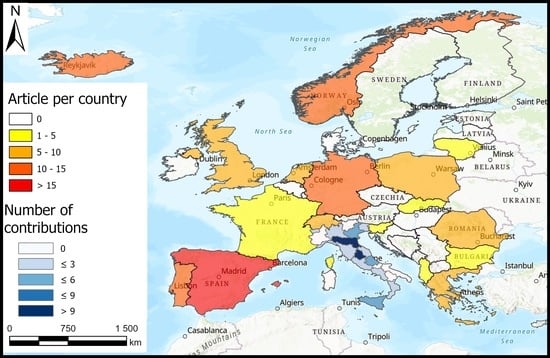
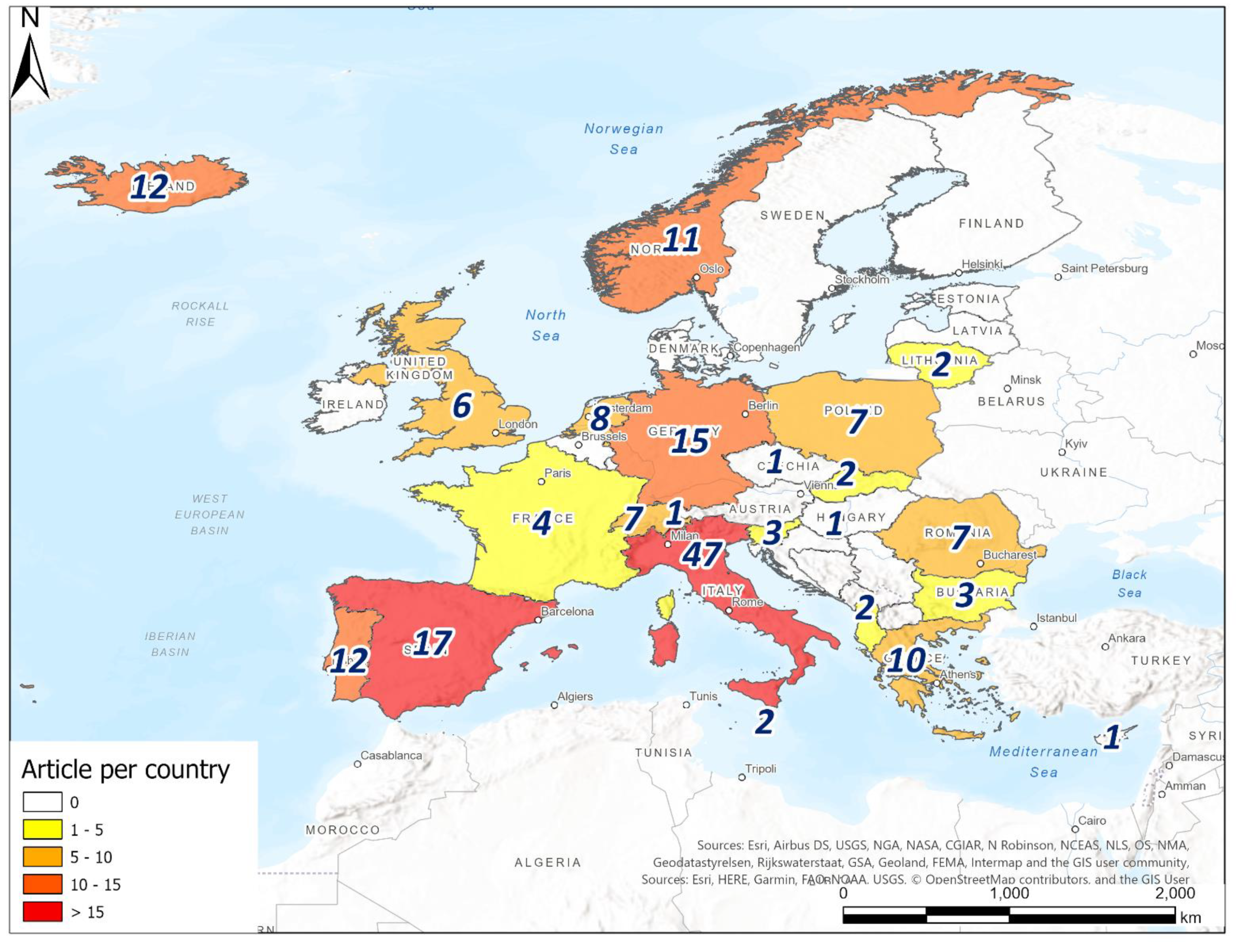
3.1. Spatial Distribution
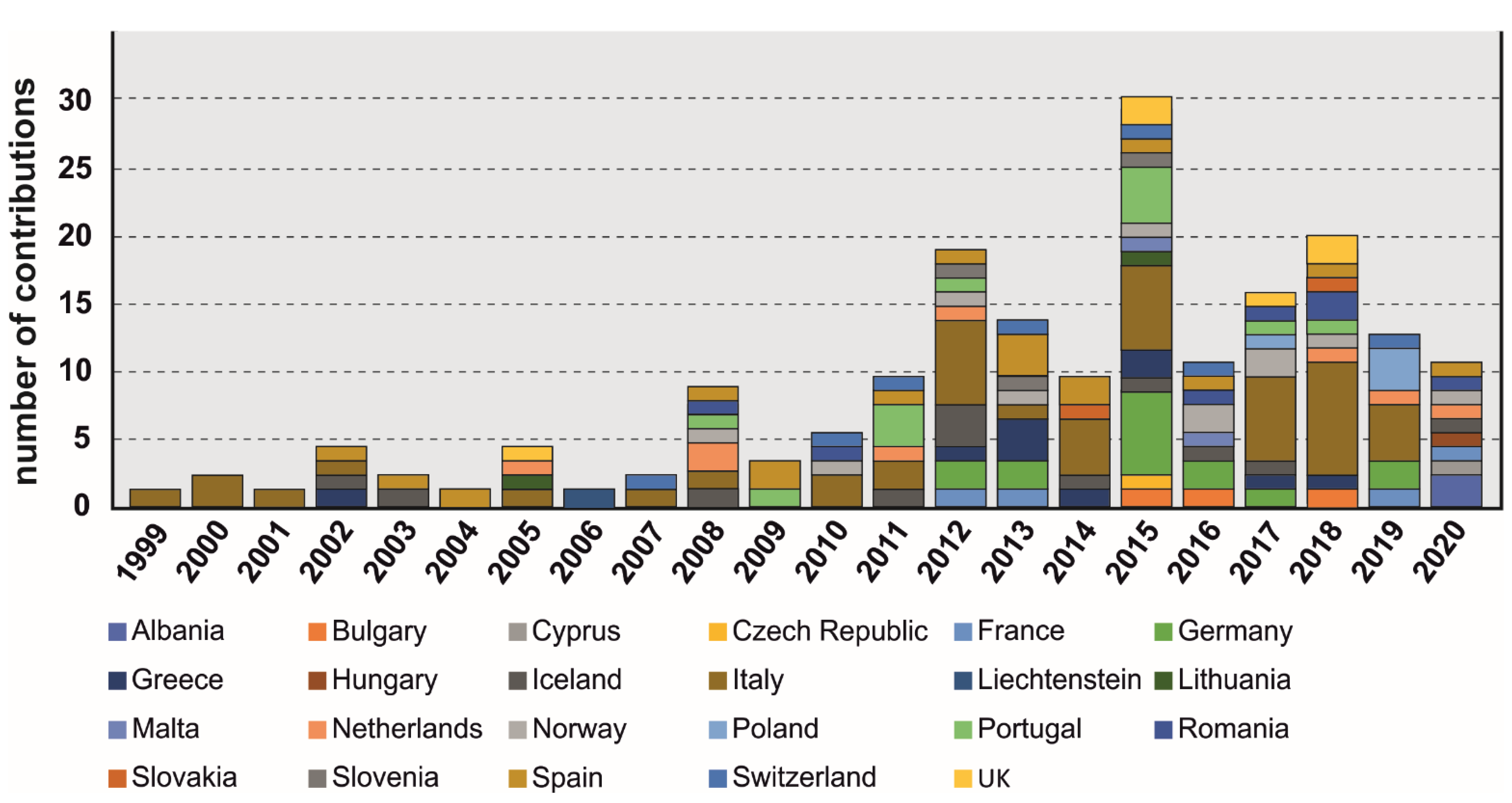
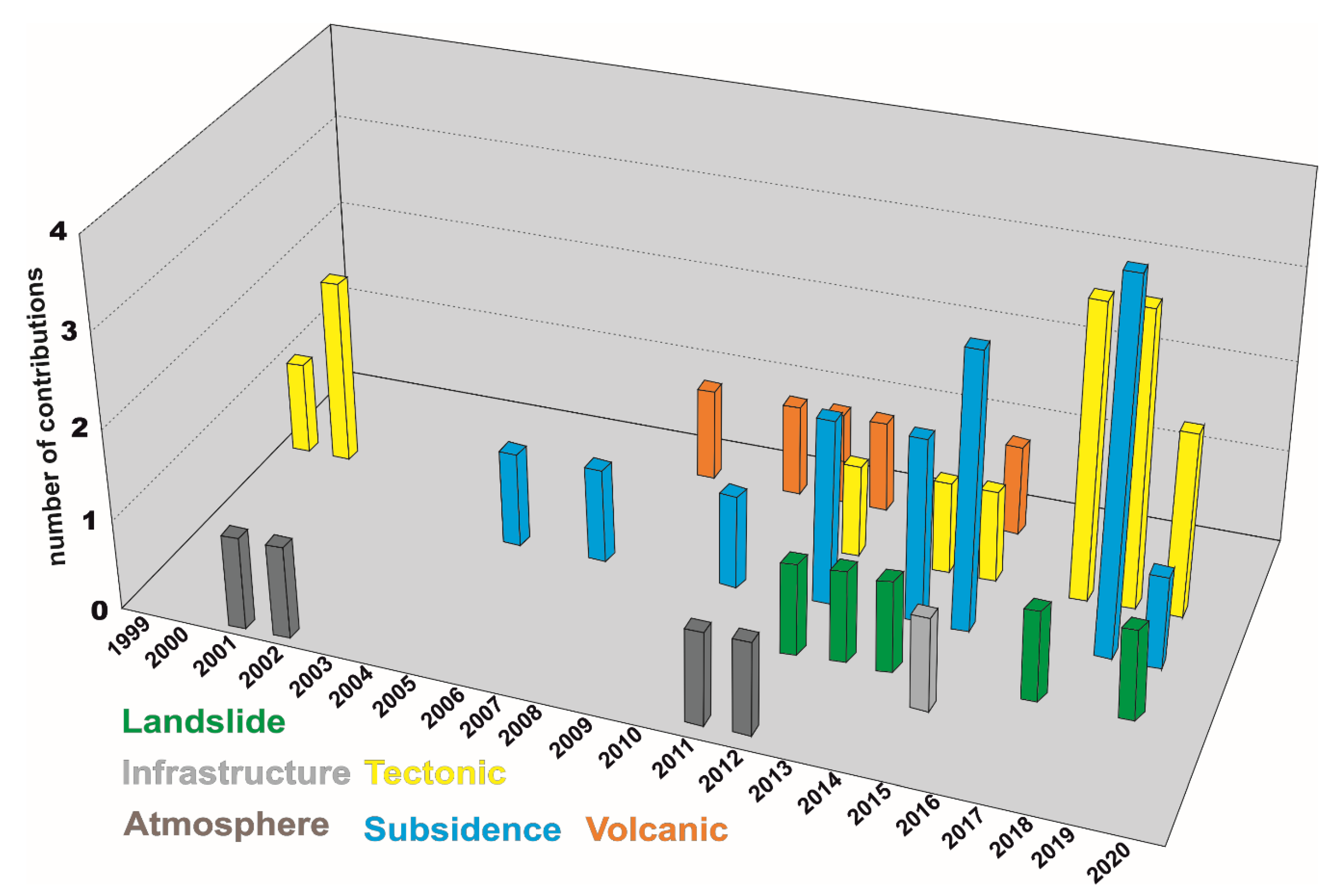
3.2. Temporal Distribution
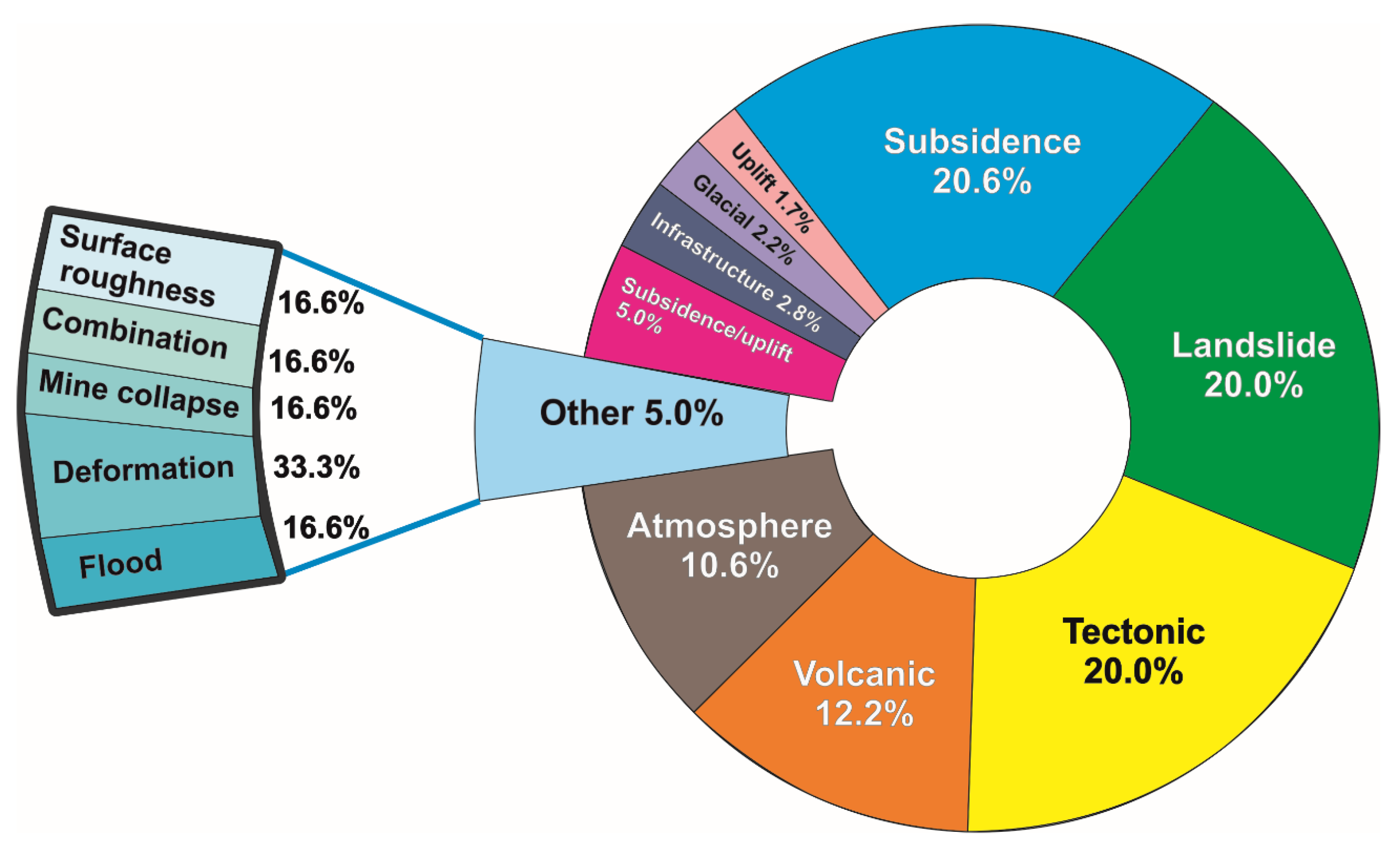
3.3. Field of Application
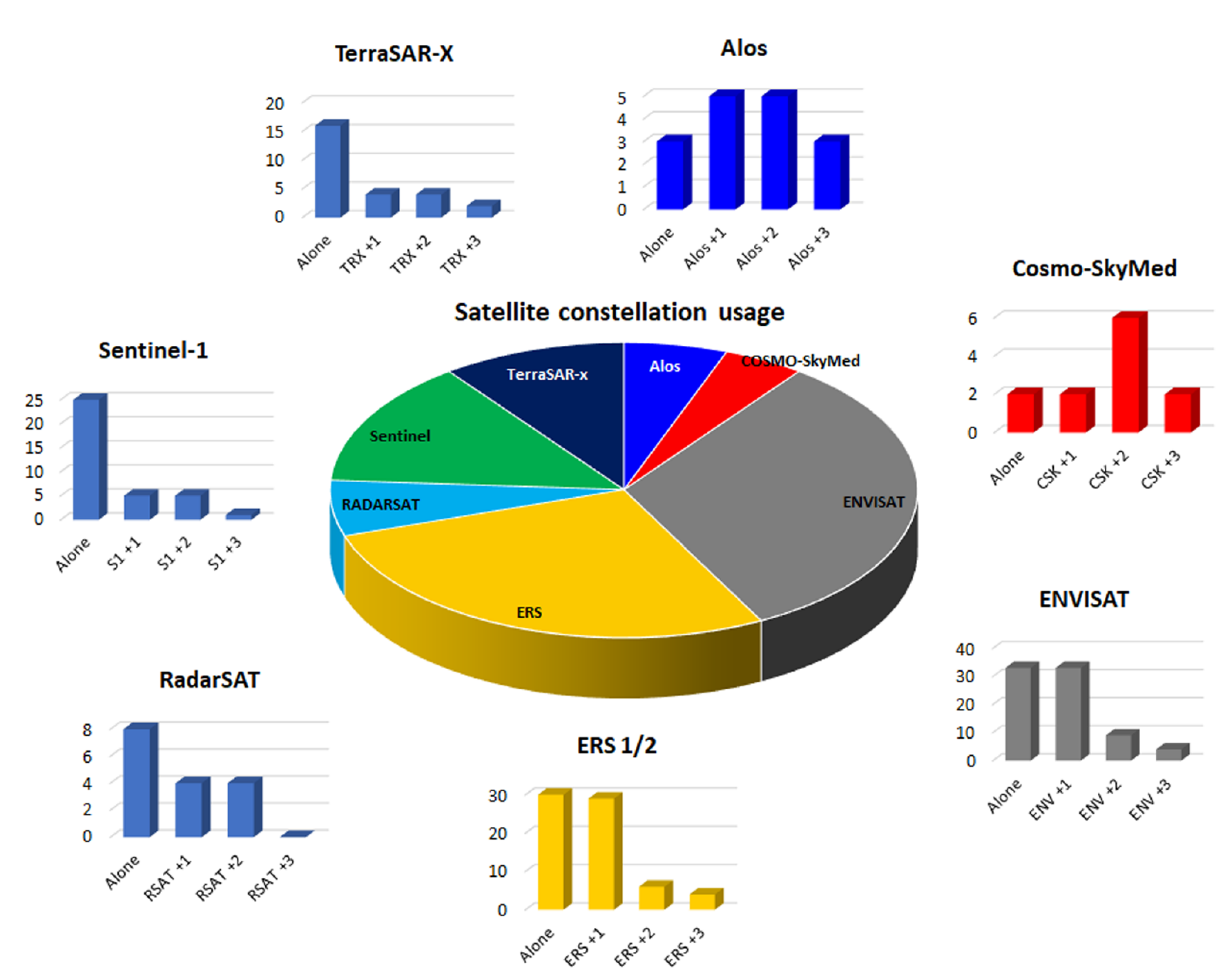
3.4. Satellite SAR Sensors
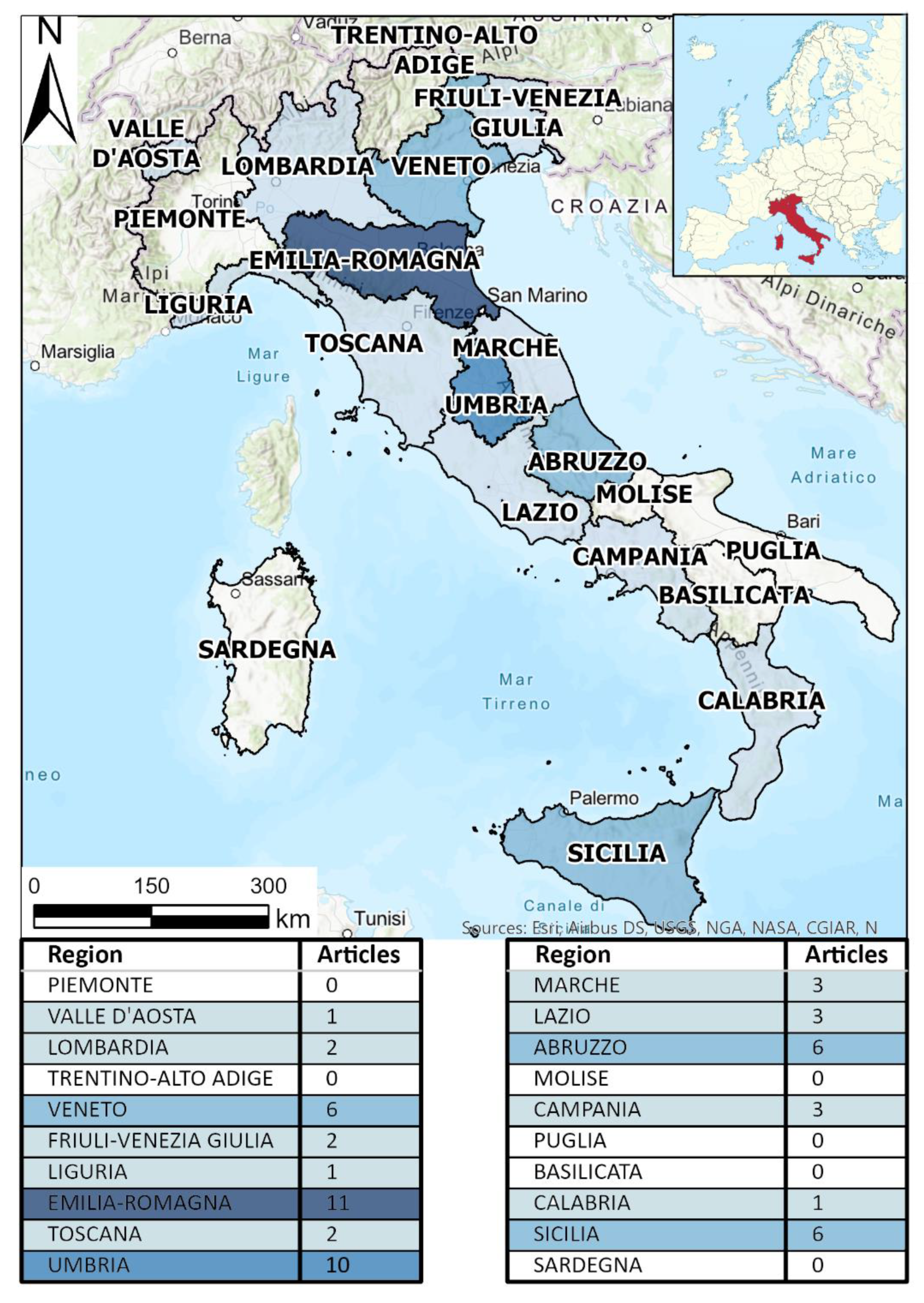
4. Temporal and Spatial Distribution in Italy
5. Discussion
6. Conclusions
Author Contributions
Funding
Conflicts of Interest
References
- Graham, L.C. Synthetic interferometer radar for topographic mapping. Proc. IEEE 1974, 62, 763–768. [Google Scholar] [CrossRef]
- Zulkifli, N.A.; Din, A.H.M.; Som, Z.A.M. Vertical land motion quantification using space-based geodetic methods: A review. In Proceedings of the IOP Conference Series: Earth and Environmental Science, Kuala Lumpur, Malaysia, 24–25 April 2018; p. 012024. [Google Scholar]
- Bruyninx, C.; Legrand, J.; Fabian, A.; Pottiaux, E. GNSS metadata and data validation in the EUREF Permanent Network. GPS Solut. 2019, 23, 1–14. [Google Scholar] [CrossRef]
- Gabriel, A.K.; Goldstein, R.M.; Zebker, H.A. Mapping small elevation changes over large areas: Differential radar interferometry. J. Geophys. Res. Solid Earth 1989, 94, 9183–9191. [Google Scholar] [CrossRef]
- Crosetto, M.; Monserrat, O.; Cuevas-González, M.; Devanthéry, N.; Crippa, B. Persistent scatterer interferometry: A review. ISPRS J. Photogramm. Remote Sens. 2016, 115, 78–89. [Google Scholar] [CrossRef]
- Tomás, R.; Li, Z. Earth Observations for Geohazards: Present and Future Challenges. Remote Sens. 2017, 9, 194. [Google Scholar] [CrossRef]
- Zhou, X.; Chang, N.-B.; Li, S. Applications of SAR interferometry in earth and environmental science research. Sensors 2009, 9, 1876–1912. [Google Scholar] [CrossRef] [PubMed]
- Pepe, A.; Calò, F. A review of interferometric synthetic aperture RADAR (InSAR) multi-track approaches for the retrieval of Earth’s surface displacements. Appl. Sci. 2017, 7, 1264. [Google Scholar] [CrossRef]
- Tomás, R.; Romero, R.; Mulas, J.; Marturià, J.J.; Mallorquí, J.J.; Lopez-Sanchez, J.M.; Herrera, G.; Gutiérrez, F.; González, P.J.; Fernández, J. Radar interferometry techniques for the study of ground subsidence phenomena: A review of practical issues through cases in Spain. Environ. Earth Sci. 2014, 71, 163–181. [Google Scholar] [CrossRef]
- Hanssen, R.F.; Weckwerth, T.M.; Zebker, H.A.; Klees, R. High-resolution water vapor mapping from interferometric radar measurements. Sci. Environ. 1999, 283, 1297–1299. [Google Scholar] [CrossRef]
- Gudmundsson, S.; Carstensen, J.M.; Sigmundsson, F. Unwrapping ground displacement signals in satellite radar interferograms with aid of GPS data and MRF regularization. IEEE Trans. Geosci. Remote Sens. 2002, 40, 1743–1754. [Google Scholar] [CrossRef]
- Simonetto, E.; Durand, S.; Burdack, J.; Polidori, L.; Morel, L.; Nicolas-Duroy, J. Combination of INSAR and GNSS measurements for ground displacement monitoring. Procedia Technol. 2014, 16, 192–198. [Google Scholar] [CrossRef][Green Version]
- Catalão, J.; Nico, G.; Hanssen, R.; Catita, C. Integration of InSAR and GPS for vertical deformation monitoring: A case study in Faial and Pico Islands. In Proceedings of the Fringe 2009 Workshop, Frascati, Italy, 30 November–4 December 2009; pp. 1–7. [Google Scholar]
- Catalão, J.; Nico, G.; Hanssen, R.; Catita, C. Merging GPS and atmospherically corrected InSAR data to map 3-D terrain displacement velocity. IEEE Trans. Geosci. Remote Sens. 2011, 49, 2354–2360. [Google Scholar] [CrossRef]
- Samsonov, S.; Tiampo, K. Analytical optimization of a DInSAR and GPS dataset for derivation of three-dimensional surface motion. IEEE Geosci. Remote Sens. Lett. 2006, 3, 107–111. [Google Scholar] [CrossRef]
- Lee, I.; Chang, H.-C.; Ge, L. GPS campaigns for validation of InSAR derived DEMs. J. Glob. Position. Syst. 2005, 4, 82–87. [Google Scholar] [CrossRef]
- Wadge, G.; Webley, P.; James, I.; Bingley, R.; Dodson, A.; Waugh, S.; Veneboer, T.; Puglisi, G.; Mattia, M.; Baker, D. Atmospheric models, GPS and InSAR measurements of the tropospheric water vapour field over Mount Etna. Geophys. Res. Lett. 2002, 29, 1905. [Google Scholar] [CrossRef]
- Cheng, S.; Perissin, D.; Lin, H.; Chen, F. Atmospheric delay analysis from GPS meteorology and InSAR APS. J. Atmos. Sol. Terr. Phys. 2012, 86, 71–82. [Google Scholar] [CrossRef]
- Heimlich, C.; Gourmelen, N.; Masson, F.; Schmittbuhl, J.; Kim, S.-W.; Azzola, J. Uplift around the geothermal power plant of Landau (Germany) as observed by InSAR monitoring. Geotherm. Energy 2015, 3, 1–12. [Google Scholar] [CrossRef]
- Farolfi, G.; Piombino, A.; Catani, F. Fusion of GNSS and Satellite Radar Interferometry: Determination of 3D Fine-Scale Map of Present-Day Surface Displacements in Italy as Expressions of Geodynamic Processes. Remote Sens. 2019, 11, 394. [Google Scholar] [CrossRef]
- Wilkinson, M.W.; McCaffrey, K.J.; Jones, R.R.; Roberts, G.P.; Holdsworth, R.E.; Gregory, L.C.; Walters, R.J.; Wedmore, L.; Goodall, H.; Iezzi, F. Near-field fault slip of the 2016 Vettore M w 6.6 earthquake (Central Italy) measured using low-cost GNSS. Sci. Rep. 2017, 7, 1–7. [Google Scholar] [CrossRef]
- Lauknes, T.; Shanker, A.P.; Dehls, J.; Zebker, H.; Henderson, I.; Larsen, Y. Detailed rockslide mapping in northern Norway with small baseline and persistent scatterer interferometric SAR time series methods. Remote Sens. Environ. 2010, 114, 2097–2109. [Google Scholar] [CrossRef]
- Bovenga, F.; Nitti, D.O.; Fornaro, G.; Radicioni, F.; Stoppini, A.; Brigante, R. Using C/X-band SAR interferometry and GNSS measurements for the Assisi landslide analysis. Int. J. Remote Sens. 2013, 34, 4083–4104. [Google Scholar] [CrossRef]
- Fernández, J.; Yu, T.-T.; Rodrıguez-Velasco, G.; González-Matesanz, J.; Romero, R.; Rodrıguez, G.; Quirós, R.; Dalda, A.; Aparicio, A.; Blanco, M. New geodetic monitoring system in the volcanic island of Tenerife, Canaries, Spain. Combination of InSAR and GPS techniques. J. Volcanol. Geotherm. Res. 2003, 124, 241–253. [Google Scholar] [CrossRef]
- Gudmundsson, M.T.; Jónsdóttir, K.; Hooper, A.; Holohan, E.P.; Halldórsson, S.A.; Ófeigsson, B.G.; Cesca, S.; Vogfjörd, K.S.; Sigmundsson, F.; Högnadóttir, T. Gradual caldera collapse at Bárdarbunga volcano, Iceland, regulated by lateral magma outflow. Science 2016, 353, 6296. [Google Scholar] [CrossRef]
- Bakon, M.; Perissin, D.; Lazecky, M.; Papco, J. Infrastructure non-linear deformation monitoring via satellite radar interferometry. Procedia Technol. 2014, 16, 294–300. [Google Scholar] [CrossRef]
- Tapete, D.; Morelli, S.; Fanti, R.; Casagli, N. Localising deformation along the elevation of linear structures: An experiment with space-borne InSAR and RTK GPS on the Roman Aqueducts in Rome, Italy. Appl. Geogr. 2015, 58, 65–83. [Google Scholar] [CrossRef]
- Magnússon, E.; Björnsson, H.; Rott, H.; Roberts, M.J.; Pálsson, F.; Guđmundsson, S.; Bennett, R.A.; Geirsson, H.; Sturkell, E. Localized uplift of Vatnajökull, Iceland: Subglacial water accumulation deduced from InSAR and GPS observations. J. Glaciol. 2011, 57, 475–484. [Google Scholar] [CrossRef]
- Gudmundsson, S.; Gudmundsson, M.T.; Björnsson, H.; Sigmundsson, F.; Rott, H.; Carstensen, J.M. Three-dimensional glacier surface motion maps at the Gjálp eruption site, Iceland, inferred from combining InSAR and other ice-displacement data. Ann. Glaciol. 2002, 34, 315–322. [Google Scholar] [CrossRef]
- Ge, L. Integration of GPS and radar interferometry. GPS Solut. 2003, 7, 52–54. [Google Scholar] [CrossRef]
- Mateus, P.; Nico, G.; Tomé, R.; Catalão, J.; Miranda, P.M. Experimental study on the atmospheric delay based on GPS, SAR interferometry, and numerical weather model data. IEEE Trans. Geosci. Remote Sens. 2012, 51, 6–11. [Google Scholar] [CrossRef]
- Spilker, J., Jr. Tropospheric effects on GPS. Glob. Posiotioning Syst. Theory Appl. 1996, 1, 517–546. [Google Scholar]
- Torres, R.; Snoeij, P.; Geudtner, D.; Bibby, D.; Davidson, M.; Attema, E.; Potin, P.; Rommen, B.; Floury, N.; Brown, M. GMES Sentinel-1 mission. Remote Sens. Environ. 2012, 120, 9–24. [Google Scholar] [CrossRef]
- Gonzalez, F.R.; Parizzi, A.; Brcic, R. Evaluating the impact of geodetic corrections on interferometric deformation measurements. In Proceedings of the EUSAR 2018, 12th European Conference on Synthetic Aperture Radar, Aachen, Germany, 4–7 June 2018; pp. 1–5. [Google Scholar]
- Shanker, A.P.; Zebker, H. Edgelist phase unwrapping algorithm for time series InSAR analysis. JOSA A 2010, 27, 605–612. [Google Scholar] [CrossRef]
- Martín-Martín, A.; Orduna-Malea, E.; Thelwall, M.; López-Cózar, E.D. Google Scholar, Web of Science, and Scopus: A systematic comparison of citations in 252 subject categories. J. Informetr. 2018, 12, 1160–1177. [Google Scholar] [CrossRef]
- Halevi, G.; Moed, H.; Bar-Ilan, J. Suitability of Google Scholar as a source of scientific information and as a source of data for scientific evaluation—Review of the literature. J. Informetr. 2017, 11, 823–834. [Google Scholar] [CrossRef]
- Bonforte, A.; Ferretti, A.; Prati, C.; Puglisi, G.; Rocca, F. Calibration of atmospheric effects on SAR interferograms by GPS and local atmosphere models: First results. J. Atmos. Sol. Terr. Phys. 2001, 63, 1343–1357. [Google Scholar] [CrossRef]
- Carlà, T.; Tofani, V.; Lombardi, L.; Raspini, F.; Bianchini, S.; Bertolo, D.; Thuegaz, P.; Casagli, N. Combination of GNSS, satellite InSAR, and GBInSAR remote sensing monitoring to improve the understanding of a large landslide in high alpine environment. Geomorphology 2019, 335, 62–75. [Google Scholar] [CrossRef]
- D’Auria, L.; Pepe, S.; Castaldo, R.; Giudicepietro, F.; Macedonio, G.; Ricciolino, P.; Tizzani, P.; Casu, F.; Lanari, R.; Manzo, M. Magma injection beneath the urban area of Naples: A new mechanism for the 2012–2013 volcanic unrest at Campi Flegrei caldera. Sci. Rep. 2015, 5, 13100. [Google Scholar] [CrossRef]
- Da Lio, C.; Teatini, P.; Strozzi, T.; Tosi, L. Understanding land subsidence in salt marshes of the Venice Lagoon from SAR Interferometry and ground-based investigations. Remote Sens. Environ. 2018, 205, 56–70. [Google Scholar] [CrossRef]
- Stramondo, S.; Tesauro, M.; Briole, P.; Sansosti, E.; Salvi, S.; Lanari, R.; Anzidei, M.; Baldi, P.; Fornaro, G.; Avallone, A. The September 26, 1997 Colfiorito, Italy, earthquakes: Modeled coseismic surface displacement from SAR interferometry and GPS. Geophys. Res. Lett. 1999, 26, 883–886. [Google Scholar] [CrossRef]
- Teatini, P.; Tosi, L.; Strozzi, T.; Carbognin, L.; Wegmüller, U.; Rizzetto, F. Mapping regional land displacements in the Venice coastland by an integrated monitoring system. Remote Sens. Environ. 2005, 98, 403–413. [Google Scholar] [CrossRef]
- Bitelli, G.; Bonsignore, F.; Del Conte, S.; Novali, F.; Pellegrino, I.; Vittuari, L. Integrated use of Advanced InSAR and GPS data for subsidence monitoring. In Engineering Geology for Society and Territory-Volume 5; Springer: Berlin/Heidelberg, Germany, 2015; pp. 147–150. [Google Scholar]
- Tosi, L.; Teatini, P.; Strozzi, T.; Carbognin, L.; Brancolini, G.; Rizzetto, F. Ground surface dynamics in the northern Adriatic coastland over the last two decades. In Rendiconti Lincei; Accademia Nazionale dei Lincei: Roma, Italy, 2010; Volume 21, pp. 115–129. [Google Scholar]
- Volpe, M.; Atzori, S.; Piersanti, A.; Melini, D. The 2009 L’Aquila earthquake coseismic rupture: Open issues and new insights from 3D finite element inversion of GPS, InSAR and strong motion data. Ann. Geophys. 2015, 58, 1–17. [Google Scholar]
- Bitelli, G.; Bonsignore, F.; Del Conte, S.; Novali, F.; Pellegrino, I.; Vittuari, L. Subsidence monitoring update for Emilia-Romagna region (Italy) by integrated use of InSAR and GNSS data. In Proceedings of the EGU General Assembly Conference Abstracts, Vienna, Austria, 27 April–2 May 2014; p. 15840. [Google Scholar]
- Bitelli, G.; Bonsignore, F.; Pellegrino, I.; Vittuari, L. Evolution of the techniques for subsidence monitoring at regional scale: The case of Emilia-Romagna region (Italy). Proc. IAHS 2015, 372, 315–321. [Google Scholar] [CrossRef]
- Cenni, N.; Loddo, F.; Zucca, F.; Meisina, C.; Baldi, P.; Belardinelli, M.; Bacchetti, M.; Mantovani, E.; Viti, M.; Casula, G. The spatio-temporal pattern of subsidence in the Po basin monitored by different techniques. Algorithms 2014, 99, 194–214. [Google Scholar]
- Cheloni, D.; De Novellis, V.; Albano, M.; Antonioli, A.; Anzidei, M.; Atzori, S.; Avallone, A.; Bignami, C.; Bonano, M.; Calcaterra, S.J. Geodetic model of the 2016 Central Italy earthquake sequence inferred from InSAR and GPS data. Geophys. Res. Lett. 2017, 44, 6778–6787. [Google Scholar] [CrossRef]
- Minet, C.; Goel, K.; Aquino, I.; Avino, R.; Berrino, G.; Caliro, S.; Chiodini, G.; De Martino, P.; Del Gaudio, C.; Ricco, C. Measuring non-linear deformation of the Campi Flegrei caldera (Naples, Italy) using a multi-method insar-geophysical approach. In Proceedings of the 2012 IEEE International Geoscience and Remote Sensing Symposium, Munich, Germany, 22–27 July 2012; pp. 1174–1177. [Google Scholar]
- Radicioni, F.; Stoppini, A.; Brigante, R.; Fornaro, G.; Bovenga, F.; NITTI, D.O. Long-term GNSS and SAR data comparison for the deformation monitoring of the Assisi landslide. In Proceedings of the FIG Working Week, Rome, Italy, 6–10 May 2012. [Google Scholar]
- Herrera, G.; Notti, D.; García-Davalillo, J.C.; Mora, O.; Cooksley, G.; Sánchez, M.; Arnaud, A.; Crosetto, M. Analysis with C-and X-band satellite SAR data of the Portalet landslide area. Landslides 2011, 8, 195–206. [Google Scholar] [CrossRef]
- Fernandez, J.; Prieto, J.F.; Escayo, J.; Camacho, A.G.; Luzón, F.; Tiampo, K.F.; Palano, M.; Abajo, T.; Pérez, E.; Velasco, J. Modeling the two-and three-dimensional displacement field in Lorca, Spain, subsidence and the global implications. Sci. Rep. 2018, 8, 14782. [Google Scholar] [CrossRef] [PubMed]
- Fernández, J.; Romero, R.; Carrasco, D.; Luzón, F.; Araña, V. InSAR volcano and seismic monitoring in Spain. Results for the period 1992–2000 and possible interpretations. Opt. Lasers Eng. 2002, 37, 285–297. [Google Scholar] [CrossRef]
- De Michele, M.; Briole, P.; Raucoules, D.; Lemoine, A.; Rigo, A. Revisiting the shallow Mw 5.1 Lorca earthquake (southeastern Spain) using C-band InSAR and elastic dislocation modelling. Remote Sens. Lett. 2013, 4, 863–872. [Google Scholar] [CrossRef]
- Prieto, J.F.; Gonzalez, P.; Seco, A.; Rodríguez-Velasco, G.; Tunini, L.; Perlock, P.A.; Arjona, A.; Aparicio, A.; Camacho, A.G.; Rundle, J. Geodetic and Structural Research in La Palma, Canary Islands, Spain: 1992–2007 Results. Pure Appl. Geophys. 2009, 166, 1461–1484. [Google Scholar] [CrossRef]
- Cong, X.; Eineder, M.; Fritz, T. Atmospheric delay compensation in differential SAR Interferometry for volcanic deformation monitoring-Study case: El Hierro. In Proceedings of the 2012 IEEE International Geoscience and Remote Sensing Symposium, Munich, Germany, 22–27 July 2012; pp. 3887–3890. [Google Scholar]
- Samsonov, S.; Tiampo, K.; González, P.J.; Prieto, J.; Camacho, A.G.; Fernández, J. Surface deformation studies of Tenerife Island, Spain from joint GPS-DInSAR observations. In Proceedings of the 2008 Second Workshop on Use of Remote Sensing Techniques for Monitoring Volcanoes and Seismogenic Areas, Naples, Italy, 11–14 November 2008; pp. 1–6. [Google Scholar]
- Rodriguez-Lloveras, X.; Puig-Polo, C.; Lantada, N.; Gili, J.A.; Marturià, J. Two decades of GPS/GNSS and DInSAR monitoring of Cardona salt mines (NE of Spain)–natural and mining-induced mechanisms and processes. Proc. IAHS 2020, 382, 167–172. [Google Scholar] [CrossRef]
- Alshawaf, F.; Fuhrmann, T.; Heck, B.; Hinz, S.; Knöpfler, A.; Luo, X.; Mayer, M.; Schenk, A.; Thiele, A.; Westerhaus, M. Integration of InSAR and GNSS observations for the determination of atmospheric water vapour. In Earth Observation of Global Changes (EOGC); Springer: Berlin/Heidelberg, Germany, 2013; pp. 147–162. [Google Scholar]
- Fuhrmann, T.; Knöpfler, A.; Mayer, M.; Schenk, A.; Westerhaus, M.; Zippelt, K.; Heck, B. An Inventory of Surface Movements in the Upper Rhine Graben Area, Southwest Germany, from SAR-Interferometry, GNSS and Precise Levelling. In IAG 150 Years; Springer: Berlin/Heidelberg, Germany, 2015; pp. 419–425. [Google Scholar]
- Heimlich, C.; Masson, F.; Schmittbuhl, J. Geodetic analysis of surface deformation at the power plant of Landau (Germany) related to the 2013–2014 event. In Proceedings of the Proc. European Geothermal Congress, Strasbourg, France, 19–23 September 2016. [Google Scholar]
- Kalia, A.; Frei, M.; Lege, T. A Copernicus downstream-service for the nationwide monitoring of surface displacements in Germany. Remote Sens. Environ. 2017, 202, 234–249. [Google Scholar] [CrossRef]
- Heublein, M.; Zhu, X.X.; Alshawaf, F.; Mayer, M.; Bamler, R.; Hinz, S. Compressive sensing for neutrospheric water vapor tomography using GNSS and InSAR observations. In Proceedings of the 2015 IEEE International Geoscience and Remote Sens. Symposium (IGARSS), Milan, Italy, 26–31 July 2015; pp. 5268–5271. [Google Scholar]
- Westerhaus, M.; Fuhrmann, T.; Mayer, M.; Zippelt, K.; Heck, B. Resolving the velocity and strain fields in the Upper Rhine Graben Area from a Combination of Levelling, GNSS and InSAR. In Proceedings of the EGU General Assembly Conference Abstracts, Vienna, Austria, 17–22 April 2016. EPSC2016-13011. [Google Scholar]
- Oliveira, S.C.; Zêzere, J.L.; Catalão, J.; Nico, G. The contribution of PSInSAR interferometry to landslide hazard in weak rock-dominated areas. Landslides 2015, 12, 703–719. [Google Scholar] [CrossRef]
- Marques, F.; Catalão, J.; Hildenbrand, A.; Madureira, P. Ground motion and tectonics in the Terceira Island: Tectonomagmatic interactions in an oceanic rift (Terceira Rift, Azores Triple Junction). Tectonophysics 2015, 651, 19–34. [Google Scholar] [CrossRef][Green Version]
- Fernandes, R.M.; Catalão, J.; Trota, A.N. The contribution of space-geodetic techniques to the understanding of the present-day geodynamics of the Azores triple junction. In Volcanoes of the Azores; Springer: Berlin/Heidelberg, Germany, 2018; pp. 57–69. [Google Scholar]
- Henriques, M.J.; Lima, J.N.; Falcão, A.P.; Mancuso, M.; Heleno, S.; Falcao, A.P. Land Subsidence in Lisbon Area: Validation Of PsinSAR Results. In Proceedings of the Proc. Of FIG Working Week, Marrakech, Morocco, 18–22 May 2011. [Google Scholar]
- Pedersen, R.; Jónsson, S.; Árnadóttir, T.; Sigmundsson, F.; Feigl, K.L. Fault slip distribution of two June 2000 Mw6. 5 earthquakes in South Iceland estimated from joint inversion of InSAR and GPS measurements. Earth Planet. Sci. Lett. 2003, 213, 487–502. [Google Scholar] [CrossRef]
- Sigmundsson, F.; Hooper, A.; Hreinsdóttir, S.; Vogfjörd, K.; Ófeigsson, B.; Rafn Heimisson, E.; Dumont, S.; Parks, M.; Spaans, K.; Gudmundsson, G.; et al. Segmented lateral dyke growth in a rifting event at Bárðarbunga volcanic system, Iceland. Nat. Geosci. 2015, 517, 191–195. [Google Scholar] [CrossRef] [PubMed]
- Parks, M.; Sigmundsson, F.; Sigurðsson, Ó.; Hooper, A.; Hreinsdóttir, S.; Ófeigsson, B.; Michalczewska, K. Deformation due to geothermal exploitation at Reykjanes, Iceland. J. Volcanol. Geotherm. Res. 2020, 391, 106438. [Google Scholar] [CrossRef]
- Spaans, K.; Sigmundsson, F.; Hreinsdóttir, S.; Öfeigsson, B. High resolution surface deformation measurements in Iceland’s Northern Volcanic Zone: Unraveling multiple deformation sources using InSAR and GPS. In Proceedings of the EGU General Assembly Conference Abstracts, Vienna, Austria, 22–27 April 2012; p. 10604. [Google Scholar]
- Eriksen, H.Ø.; Lauknes, T.R.; Larsen, Y.; Corner, G.D.; Bergh, S.G.; Dehls, J.; Kierulf, H.P. Visualizing and interpreting surface displacement patterns on unstable slopes using multi-geometry satellite SAR interferometry (2D InSAR). Remote Sens. Environ. 2017, 191, 297–312. [Google Scholar] [CrossRef]
- L’Heureux, J.; Long, M.; Vanneste, M.; Sauvin, G.; Hansen, L.; Polom, U.; Lecomte, I.; Dehls, J.; Janbu, N. On the prediction of settlement from high-resolution shear-wave reflection seismic data: The Trondheim harbour case study, mid Norway. Eng. Geol. 2013, 167, 72–83. [Google Scholar] [CrossRef]
- Shamshiri, R.; Motagh, M.; Nahavandchi, H.; Haghighi, M.H.; Hoseini, M.J.R.S.o.E. Improving tropospheric corrections on large-scale Sentinel-1 interferograms using a machine learning approach for integration with GNSS-derived zenith total delay (ZTD). Remote Sens. Environ. 2020, 239, 111608. [Google Scholar] [CrossRef]
- Böhme, M.; Bunkholt, H.; Oppikofer, T.; Dehls, J.; Hermanns, R.; Eriksen, H.; Lauknes, T.; Eiken, T. Using 2D InSAR, dGNSS and structural field data to understand the deformation mechanism of the unstable rock slope Gamanjunni 3, northern Norway. Landslides and Engineered Slopes. Experience, Theory and Practice. In Proceedings of the 12th International Symposium on Landslides, Napoli, Italy, 12–19 June 2016; p. 443. [Google Scholar]
- Dehls, J.; Fischer, L.; Böhme, M.; Saintot, A.; Hermanns, R.; Oppikofer, T.; Lauknes, T.; Larsen, Y.; Blikra, L. Landslide Monitoring in Western Norway Using High Resolution TerraSAR-X and Radarsat-2 InSAR; CRC Press: Milton, UK, 2012; pp. 1321–1325. [Google Scholar]
- Dehls, J.; Henderson, I.; Lauknes, T.; Larsen, Y. Regional landslide mapping and detailed site characterization using InSAR. In Proceedings of the “GeoEdmonton”, Edmonton, AB, Canada, 21–24 September 2008; pp. 21–24. [Google Scholar]
- Avallone, A.; Cirella, A.; Cheloni, D.; Tolomei, C.; Theodoulidis, N.; Piatanesi, A.; Briole, P.; Ganas, A. Near-source high-rate GPS, strong motion and InSAR observations to image the 2015 Lefkada (Greece) Earthquake rupture history. Sci. Rep. 2017, 7, 10358. [Google Scholar] [CrossRef]
- Lagios, E.; Papadimitriou, P.; Novali, F.; Sakkas, V.; Fumagalli, A.; Vlachou, K.; Del Conte, S. Combined seismicity pattern analysis, DGPS and PSInSAR studies in the broader area of Cephalonia (Greece). Tectonophysics 2012, 524, 43–58. [Google Scholar] [CrossRef]
- Papoutsis, I.; Papanikolaou, X.; Floyd, M.; Ji, K.; Kontoes, C.; Paradissis, D.; Zacharis, V. Mapping inflation at Santorini volcano, Greece, using GPS and InSAR. Geophys. Res. Lett. 2013, 40, 267–272. [Google Scholar] [CrossRef]
- Elias, P.; Sykioti, O.; Drakatos, G.; Paronis, D.; Chousianitis, K.; Sabatakakis, N.; Anastasopoulos, V.; Briole, P. Landslides modelling and monitoring by exploiting satellite SAR acquisitions, optical imagery, GPS and in-situ measurements in Greece. Preliminary results. In Proceedings of the EGU General Assembly Conference Abstracts, Vienna, Austria, 27 April–2 May 2014; p. 4402. [Google Scholar]
- Briole, P.; Avallone, A.; Agatza-Balodimou, E.; Billiris, H.; Charade, O.; Lyon-Caen, H.; Mitsakaki, C.; Papazissi, K.; Paradissis, D.; Veis, G. A ten years analysis of deformation in the Corinthian Gulf via GPS and SAR Interferometry. In Proceedings of the Wegener Meeting, Athens, Greece, 12–14 June 2002. [Google Scholar]
- Sakkas, V.; Novali, F.; Lagios, E.; Ferretti, A.; Vassilopoulou, S.; Bellotti, F.; Allievi, J. Combined Squee-SAR TM and GPS ground deformation study of Nisyros-Yali volcanic field (Greece) for period 2002–2012. In Proceedings of the 2015 IEEE International Geoscience and Remote Sensing Symposium (IGARSS), Milan, Italy, 26–31 July 2015; pp. 4672–4675. [Google Scholar]
- Borgia, A.; Lanari, R.; Sansosti, E.; Tesauro, M.; Berardino, P.; Fornaro, G.; Neri, M.; Murray, J. Actively growing anticlines beneath Catania from the distal motion of Mount Etna’s decollement measured by SAR interferometry and GPS. Geophys. Res. Lett. 2000, 27, 3409–3412. [Google Scholar] [CrossRef]
- Salvi, S.; Stramondo, S.; Cocco, M.; Tesauro, M.; Hunstad, I.; Anzidei, M.; Briole, P.; Baldi, P.; Sansosti, E.; Fornaro, G. Modeling coseismic displacements resulting from SAR interferometry and GPS measurements during the 1997 Umbria-Marche seismic sequence. J. Seismol. 2000, 4, 479–499. [Google Scholar] [CrossRef]
- Colesanti, C.; Wasowski, J. Investigating landslides with space-borne Synthetic Aperture Radar (SAR) interferometry. Eng. Geol. 2006, 88, 173–199. [Google Scholar] [CrossRef]
- Novellino, A.; Cigna, F.; Brahmi, M.; Sowter, A.; Bateson, L.; Marsh, S. Assessing the Feasibility of a National InSAR Ground Deformation Map of Great Britain with Sentinel-1. Geosciences 2017, 7, 19. [Google Scholar] [CrossRef]
- Lanari, R.; Bonano, M.; Casu, F.; Luca, C.D.; Manunta, M.; Manzo, M.; Onorato, G.; Zinno, I. Automatic generation of sentinel-1 continental scale DInSAR deformation time series through an extended P-SBAS processing pipeline in a cloud computing environment. Remote Sens. 2020, 12, 2961. [Google Scholar] [CrossRef]
- Fuhrmann, T.; Caro Cuenca, M.; Knöpfler, A.; Van Leijen, F.; Mayer, M.; Westerhaus, M.; Hanssen, R.; Heck, B. Estimation of small surface displacements in the Upper Rhine Graben area from a combined analysis of PS-InSAR, levelling and GNSS data. Geophys. J. Int. 2015, 203, 614–631. [Google Scholar] [CrossRef]
- Fuhrmann, T.; Knöpfler, A.; Mayer, M.; Schenk, A.; Westerhaus, M.; Zippelt, K.; Heck, B. Towards a fusion of SAR-interferometry, GNSS and precise levelling in the Upper Rhine Graben Area, Southwest Germany. In Proceedings of the ESA Living Planet Symposium, Edinburgh, UK, 9–13 September 2013. SP-722. [Google Scholar]
- Haghshenas Haghighi, M.; Motagh, M. Sentinel-1 InSAR over Germany: Large-scale interferometry, atmospheric effects, and ground deformation mapping. Zeitschrift Geodäsie Geoinformation Landmanagement 2017, 2017, 245–256. [Google Scholar]
- Fiaschi, S.; Fabris, M.; Floris, M.; Achilli, V. Estimation of land subsidence in deltaic areas through differential SAR interferometry: The Po River Delta case study (Northeast Italy). Int. J. Remote Sens. 2018, 39, 8724–8745. [Google Scholar] [CrossRef]
- Zerbini, S.; Richter, B.; Rocca, F.; van Dam, T.; Matonti, F. A combination of space and terrestrial geodetic techniques to monitor land subsidence: Case study, the Southeastern Po Plain, Italy. J. Geophys. Res. Solid Earth 2007, 112, B05401. [Google Scholar] [CrossRef]
- Bock, Y.; Wdowinski, S.; Ferretti, A.; Novali, F.; Fumagalli, A. Recent subsidence of the Venice Lagoon from continuous GPS and interferometric synthetic aperture radar. Geochem. Geophys. Geosyst. 2012, 13. [Google Scholar] [CrossRef]
- Teatini, P.; Tosi, L.; Strozzi, T.; Carbognin, L.; Cecconi, G.; Rosselli, R.; Libardo, S. Resolving land subsidence within the Venice Lagoon by persistent scatterer SAR interferometry. Phys. Chem. Earth Parts A/B/C 2012, 40, 72–79. [Google Scholar] [CrossRef]
- Da Lio, C.; Tosi, L. Land subsidence in the Friuli Venezia Giulia coastal plain, Italy: 1992–2010 results from SAR-based interferometry. Sci. Total Environ. 2018, 633, 752–764. [Google Scholar] [CrossRef]
- Del Soldato, M.; Farolfi, G.; Rosi, A.; Raspini, F.; Casagli, N. Subsidence Evolution of the Firenze–Prato–Pistoia Plain (Central Italy) Combining PSI and GNSS Data. Remote Sens. 2018, 10, 1146. [Google Scholar] [CrossRef]
- Cianflone, G.; Tolomei, C.; Brunori, C.A.; Dominici, R. InSAR time series analysis of natural and anthropogenic coastal plain subsidence: The case of Sibari (Southern Italy). Remote Sens. 2015, 7, 16004–16023. [Google Scholar] [CrossRef]
- Béjar-Pizarro, M.; Guardiola-Albert, C.; García-Cárdenas, R.P.; Herrera, G.; Barra, A.; López Molina, A.; Tessitore, S.; Staller, A.; Ortega-Becerril, J.A.; García-García, R.P. Interpolation of GPS and geological data using InSAR deformation maps: Method and application to land subsidence in the alto guadalentín aquifer (SE Spain). Remote Sens. 2016, 8, 965. [Google Scholar] [CrossRef]
- Bonì, R.; Herrera, G.; Meisina, C.; Notti, D.; Béjar-Pizarro, M.; Zucca, F.; González, P.J.; Palano, M.; Tomás, R.; Fernández, J. Twenty-year advanced DInSAR analysis of severe land subsidence: The Alto Guadalentín Basin (Spain) case study. Eng. Geol. 2015, 198, 40–52. [Google Scholar] [CrossRef]
- Heleno, S.I.; Oliveira, L.G.; Henriques, M.J.; Falcão, A.P.; Lima, J.N.; Cooksley, G.; Ferretti, A.; Fonseca, A.M.; Lobo-Ferreira, J.P.; Fonseca, J.F. Persistent scatterers interferometry detects and measures ground subsidence in Lisbon. Remote Sens. Environ. 2011, 115, 2152–2167. [Google Scholar] [CrossRef]
- Graniczny, M.; Cyziene, J.; van Leijen, F.; Minkevicius, W.; Mikulenas, V.; Satkunas, J.; Przylucka, M.; Kowalski, Z.; Uscinowicz, S.; Jeglinski, W. Vertical ground movements in the Polish and Lithuanian Baltic coastal area as measured by satellite interferometry. Baltica 2015, 28. [Google Scholar] [CrossRef]
- Krynski, J.; Zak, L.; Ziolkowski, D.; Cisak, J.; Lagiewska, M. Estimation of height changes of GNSS stations from the solutions of short vectors and PSI measurements. Geod. Cartogr. 2017, 66, 73–83. [Google Scholar] [CrossRef]
- Armaş, I.; Gheorghe, M.; Lendvai, A.M.; Dumitru, P.D.; Bădescu, O.; Călin, A. InSAR validation based on GNSS measurements in Bucharest. Int. J. Remote Sens. 2016, 37, 5565–5580. [Google Scholar] [CrossRef]
- Armaş, I.; Mendes, D.A.; Popa, R.-G.; Gheorghe, M.; Popovici, D. Long-term ground deformation patterns of Bucharest using multi-temporal InSAR and multivariate dynamic analyses: A possible transpressional system? Sci. Rep. 2017, 7, 43762. [Google Scholar] [CrossRef]
- Czikhardt, R.; Papčo, J.; Bakoň, M. Feasibility of the Sentinel-1 Multi-temporal InSAR system based on the SNAP and StaMPS: Case study from the Tatra Mts., Slovakia. Procedia Comput. Sci. 2018, 138, 366–373. [Google Scholar] [CrossRef]
- Tondaś, D.; Pawłuszek, K.; Ilieva, M.; Kapłon, J.; Rohm, W. Investigation for mining-induced deformation in Upper Silesia Coal Basin with multi-GNSS in Near Real-Time. In Proceedings of the 4th Joint International Symposium on Deformation Monitoring (JISDM), Athens, Greece, 15–17 May 2019. [Google Scholar]
- Kadlečík, P.; Kajzar, V.; Nekvasilová, Z.; Wegmüller, U.; Doležalová, H. Evaluation of the subsidence based on dInSAR and GPS measurements near Karvina, Czech Republic. AUC Geogr. 2015, 50, 51–61. [Google Scholar] [CrossRef]
- Alshammari, L.; Large, D.J.; Boyd, D.S.; Sowter, A.; Anderson, R.; Andersen, R.; Marsh, S. Long-term peatland condition assessment via surface motion monitoring using the ISBAS DInSAR technique over the Flow Country, Scotland. Remote Sens. 2018, 10, 1103. [Google Scholar] [CrossRef]
- Mason, P.; Ghail, R.; Bischoff, C.; Skipper, J. Detecting and Monitoring Small-Scale Discrete Ground Movements across London, Using Persistent Scatterer InSAR (PSI). 2015. Available online: https://spiral.imperial.ac.uk/handle/10044/1/26693 (accessed on 31 March 2021).
- Bardi, F.; Raspini, F.; Ciampalini, A.; Kristensen, L.; Rouyet, L.; Lauknes, T.R.; Frauenfelder, R.; Casagli, N. Space-borne and ground-based InSAR data integration: The Åknes test site. Remote Sens. 2016, 8, 237. [Google Scholar] [CrossRef]
- Booth, A.M.; Dehls, J.; Eiken, T.; Fischer, L.; Hermanns, R.L.; Oppikofer, T. Integrating diverse geologic and geodetic observations to determine failure mechanisms and deformation rates across a large bedrock landslide complex: The Osmundneset landslide, Sogn og Fjordane, Norway. Landslides 2015, 12, 745–756. [Google Scholar] [CrossRef]
- Eckerstorfer, M.; Eriksen, H.Ø.; Rouyet, L.; Christiansen, H.H.; Lauknes, T.R.; Blikra, L.H. Comparison of geomorphological field mapping and 2D-InSAR mapping of periglacial landscape activity at Nordnesfjellet, northern Norway. Earth Surface Process. Landf. 2018, 43, 2147–2156. [Google Scholar] [CrossRef]
- Delaloye, R.; Strozzi, T.; Lambiel, C.; Perruchoud, E. Landslide-like development of rockglaciers detected with ERS-1/2 SAR interferometry. In Proceedings of the ESA FRINGE Symposium 2007, Frascati, Italy, 26–30 November 2007. [Google Scholar]
- Kenner, R.; Phillips, M.; Beutel, J.; Limpach, P.; Papke, J.; Hasler, A.; Raetzo, H. Investigating the dynamics of a rock glacier using terrestrial laser scanning, time-lapse photography, in situ GPS measurements and satellite SAR inter-ferometry: Ritigraben rock glacier, Switzerland. In Proceedings of the International Conference on Permafrost, Potsdam, Germany, 20–24 June 2016; pp. 20–24. [Google Scholar]
- Barboux, C.; Delaloye, R.; Strozzi, T.; Collet, C.; Raetzo, H. TSX InSAR assessment for slope instabilities monitoring in alpine periglacial environment (Western Swiss Alps, Switzerland). In Proceedings of the Proc. ESA FRINGE, Frascati, Italy, 19–23 September 2011; pp. 19–23. [Google Scholar]
- Barboux, C.; Strozzi, T.; Delaloye, R.; Wegmüller, U.; Collet, C. Mapping slope movements in Alpine environments using TerraSAR-X interferometric methods. ISPRS J. Photogramm. Remote Sens. 2015, 109, 178–192. [Google Scholar] [CrossRef]
- Strozzi, T.; Ambrosi, C.; Raetzo, H. Interpretation of aerial photographs and satellite SAR interferometry for the inventory of landslides. Remote Sens. 2013, 5, 2554–2570. [Google Scholar] [CrossRef]
- Strozzi, T.; Delaloye, R.; Kääb, A.; Ambrosi, C.; Perruchoud, E.; Wegmüller, U. Combined observations of rock mass movements using satellite SAR interferometry, differential GPS, airborne digital photogrammetry, and airborne photography interpretation. J. Geophys. Res. Earth Surf. 2010, 115. [Google Scholar] [CrossRef]
- Bayer, B.; Simoni, A.; Schmidt, D.; Bertello, L. Using advanced InSAR techniques to monitor landslide deformations induced by tunneling in the Northern Apennines, Italy. Eng. Geol. 2017, 226, 20–32. [Google Scholar] [CrossRef]
- Lu, P.; Catani, F.; Tofani, V.; Casagli, N. Quantitative hazard and risk assessment for slow-moving landslides from Persistent Scatterer Interferometry. Landslides 2014, 11, 685–696. [Google Scholar] [CrossRef]
- Crosetto, M.; Gili, J.; Monserrat, O.; Cuevas-González, M.; Corominas, J.; Serral, D. Interferometric SAR monitoring of the Vallcebre landslide (Spain) using corner reflectors. Nat. Hazards Earth Syst. Sci. 2013, 13, 923–933. [Google Scholar] [CrossRef]
- García-Davalillo, J.C.; Herrera, G.; Notti, D.; Strozzi, T.; Álvarez-Fernández, I. DInSAR analysis of ALOS PALSAR images for the assessment of very slow landslides: The Tena Valley case study. Landslides 2014, 11, 225–246. [Google Scholar] [CrossRef]
- Herrera, G.; Gutiérrez, F.; García-Davalillo, J.; Guerrero, J.; Notti, D.; Galve, J.; Fernández-Merodo, J.; Cooksley, G. Multi-sensor advanced DInSAR monitoring of very slow landslides: The Tena Valley case study (Central Spanish Pyrenees). Remote Sens. Environ. 2013, 128, 31–43. [Google Scholar] [CrossRef]
- Komac, M.; Holley, R.; Mahapatra, P.; van der Marel, H.; Bavec, M. Coupling of GPS/GNSS and radar interferometric data for a 3D surface displacement monitoring of landslides. Landslides 2015, 12, 241–257. [Google Scholar] [CrossRef]
- Mahapatra, P.; van der Marel, H.; Hanssen, R.; Holley, R.; Samiei-Esfahany, S.; Komac, M.; Fromberg, A. Radar transponders and their combination with GNSS for deformation monitoring. In Proceedings of the 2012 the IEEE International Geoscience and Remote Sensing Symposium, Munich, Germany, 22–27 July 2012; pp. 3891–3894. [Google Scholar]
- Mahapatra, P.S.; Samiei-Esfahany, S.; van der Marel, H.; Hanssen, R.F. On the use of transponders as coherent radar targets for SAR interferometry. IEEE Trans. Geosci. Remote Sens. 2013, 52, 1869–1878. [Google Scholar] [CrossRef]
- Mantovani, M.; Devoto, S.; Piacentini, D.; Prampolini, M.; Soldati, M.; Pasuto, A. Advanced SAR interferometric analysis to support geomorphological interpretation of slow-moving coastal landslides (Malta, Mediterranean Sea). Remote Sens. 2016, 8, 443. [Google Scholar] [CrossRef]
- Piacentini, D.; Devoto, S.; Mantovani, M.; Pasuto, A.; Prampolini, M.; Soldati, M. Landslide susceptibility modeling assisted by Persistent Scatterers Interferometry (PSI): An example from the northwestern coast of Malta. Nat. Hazards 2015, 78, 681–697. [Google Scholar] [CrossRef]
- Atanasova, M.; Nikolov, H. Ground displacements detection in Trifon Zarezan landslide based on GNSS and SAR data. MMM Geo Inf. 2018, 11, 7–15. [Google Scholar]
- Themistocleous, K.; Danezis, C.; Gikas, V. Monitoring ground deformation of cultural heritage sites using SAR and geodetic techniques: The case study of Choirokoitia, Cyprus. Appl. Geomat. 2020, 1–13. [Google Scholar] [CrossRef]
- Raucoules, D.; De Michele, M.; Malet, J.-P.; Ulrich, P. Time-variable 3D ground displacements from high-resolution synthetic aperture radar (SAR). Application to La Valette landslide (South French Alps). Remote Sens. Environ. 2013, 139, 198–204. [Google Scholar] [CrossRef]
- Bozsó, I.; Bányai, L.; Hooper, A.; Sz, E.; Wesztergom, V. Integration of Sentinel-1 Interferometry and GNSS Networks for Derivation of 3-D Surface Changes. IEEE Geosci. Remote Sens. Lett. 2021, 18, 692–696. [Google Scholar] [CrossRef]
- Cheloni, D.; Giuliani, R.; D’Anastasio, E.; Atzori, S.; Walters, R.; Bonci, L.; D’Agostino, N.; Mattone, M.; Calcaterra, S.; Gambino, P. Coseismic and post-seismic slip of the 2009 L’Aquila (central Italy) Mw 6.3 earthquake and implications for seismic potential along the Campotosto fault from joint inversion of high-precision levelling, InSAR and GPS data. Tectonophysics 2014, 622, 168–185. [Google Scholar] [CrossRef]
- Wang, Y.-Z.; Zhu, J.-J.; Ou, Z.-Q.; Li, Z.-W.; Xing, X.-M. Coseismic slip distribution of 2009 L’Aquila earthquake derived from InSAR and GPS data. J. Cent. South Univ. 2012, 19, 244–251. [Google Scholar] [CrossRef]
- Nespoli, M.; Belardinelli, M.E.; Gualandi, A.; Serpelloni, E.; Bonafede, M. Poroelasticity and fluid flow modeling for the 2012 Emilia-Romagna earthquakes: Hints from GPS and InSAR data. Geofluids 2018, 1–15. [Google Scholar] [CrossRef]
- Cheloni, D. Geodetic model of the 2016 Central Italy earthquake sequence inferred from InSAR and GPS measurements. In Proceedings of the EGU General Assembly Conference Abstracts, Vienna, Austria, 23–28 April 2017; p. 9191. [Google Scholar]
- Cheloni, D.; D’Agostino, N.; Scognamiglio, L.; Tinti, E.; Bignami, C.; Avallone, A.; Giuliani, R.; Calcaterra, S.; Gambino, P.; Mattone, M. Heterogeneous Behavior of the Campotosto Normal Fault (Central Italy) Imaged by InSAR GPS and Strong-Motion Data: Insights from the 18 January 2017 Events. Remote Sens. 2019, 11, 1482. [Google Scholar] [CrossRef]
- Wang, L.; Gao, H.; Feng, G.; Xu, W. Source parameters and triggering links of the earthquake sequence in central Italy from 2009 to 2016 analyzed with GPS and InSAR data. Tectonophysics 2018, 744, 285–295. [Google Scholar] [CrossRef]
- Walters, R.J.; Gregory, L.C.; Wedmore, L.N.; Craig, T.J.; McCaffrey, K.; Wilkinson, M.; Chen, J.; Li, Z.; Elliott, J.R.; Goodall, H. Dual control of fault intersections on stop-start rupture in the 2016 Central Italy seismic sequence. Earth Planet. Sci. Lett. 2018, 500, 1–14. [Google Scholar] [CrossRef]
- Farolfi, G.; Bianchini, S.; Casagli, N. Integration of GNSS and satellite InSAR data: Derivation of fine-scale vertical surface motion maps of Po Plain, Northern Apennines, and Southern Alps, Italy. IEEE Trans. Geosci. Remote Sens. 2018, 57, 319–328. [Google Scholar] [CrossRef]
- Vollrath, A.; Zucca, F.; Bekaert, D.; Bonforte, A.; Guglielmino, F.; Hooper, A.J.; Stramondo, S. Decomposing DInSAR time-series into 3-D in combination with GPS in the case of low strain rates: An application to the Hyblean Plateau, Sicily, Italy. Remote Sens. 2017, 9, 33. [Google Scholar] [CrossRef]
- Sakkas, V.; Novali, F.; Vassilopoulou, S.; Damiata, B.N.; Fumagalli, A.; Lagios, E. Combined PSI And Differential GPS Study Of Zakynthos Island (W. Greece) For The Period 1992–2012. In Proceedings of the ESA Living Planet Symposium, Edinburgh, UK, 9–13 September 2013; p. 214. [Google Scholar]
- Briole, P.; Elias, P.; Parcharidis, I.; Bignami, C.; Benekos, G.; Samsonov, S.; Kyriakopoulos, C.; Stramondo, S.; Chamot-Rooke, N.; Drakatou, M. The seismic sequence of January–February 2014 at Cephalonia Island (Greece): Constraints from SAR interferometry and GPS. Geophys. Suppl. Mon. Not. R. Astron. Soc. 2015, 203, 1528–1540. [Google Scholar] [CrossRef][Green Version]
- Decriem, J.; Árnadóttir, T.J.T. Transient crustal deformation in the South Iceland Seismic Zone observed by GPS and InSAR during 2000–2008. Tectonophysics 2012, 581, 6–18. [Google Scholar] [CrossRef]
- Metzger, S.; Jónsson, S. Plate boundary deformation in North Iceland during 1992–2009 revealed by InSAR time-series analysis and GPS. Tectonophysics 2014, 634, 127–138. [Google Scholar] [CrossRef]
- Juncu, D.; Árnadóttir, T.; Hooper, A.; Gunnarsson, G. Anthropogenic and natural ground deformation in the Hengill geothermal area, Iceland. J. Geophys. Res. Solid Earth 2017, 122, 692–709. [Google Scholar] [CrossRef]
- Jonsson, S. Importance of post-seismic viscous relaxation in southern Iceland. Nat. Geosci. 2008, 1, 136–139. [Google Scholar] [CrossRef]
- Szűcs, E.; Bozsó, I.; Kovács, I.J.; Bányai, L.; Gál, Á.; Szakács, A.; Wesztergom, V. Probing tectonic processes with space geodesy in the south Carpathians: Insights from archive SAR data. Acta Geod. Geophys. 2018, 53, 331–345. [Google Scholar] [CrossRef]
- Gheorghe, M.; Armaș, I.; Năstase, E.-I.; Munteanu, A. Potential of InSAR Monitoring for Seismic Areas in Romanian; Center for Risk Studies, Spatial Modelling, Terrestrial and Coastal System Dynamics: Bucharest, Romania, 2018; pp. 23–31. [Google Scholar]
- Zoran, M. Use of geospatial and in situ information for seismic hazard assessment in Vrancea area, Romania. In Proceedings of the 2008 Second Workshop on Use of Remote Sensing Techniques for Monitoring Volcanoes and Seismogenic Areas, Naples, Italy, 11–14 November 2008; pp. 1–5. [Google Scholar]
- Ganas, A.; Elias, P.; Briole, P.; Cannavo, F.; Valkaniotis, S.; Tsironi, V.; Partheniou, E. Ground deformation and seismic fault model of the M6. 4 Durres (Albania) Nov. 26, 2019 earthquake, based on GNSS/INSAR observations. Geosciences 2020, 10, 210. [Google Scholar] [CrossRef]
- Grassi, F.; Cenni, N.; Mancini, F. Combination of satellite SAR and GNSS data of co-seismic deformation after the November 26, 2019 Albania earthquake: First results. In Proceedings of the EGU General Assembly Conference Abstracts, Vienna, Austria, 4–8 May 2020; p. 4553. [Google Scholar]
- Atanasova, M.; Nikolov, H. Detection of the Earth crust deformation in Provadia area using InSAR technique. In XXVI International Symposium on Modern Technologies, Education and Professional Practice in Geodesy and Related Fields; Sofia, Bulgary, 2016; Available online: https://www.researchgate.net/publication/334964442_XXIV_-th_INTERNATIONAL_SYMPOSIUM_MODERN_TECHNOLOGIES_EDUCATION_AND_PROFESSIONAL_PRACTICE_IN_GEODESY_AND_RELATED_FIELDS_Study_of_the_earth_crust_movements_on_the_territory_of_Bulgaria_with_GPS (accessed on 31 March 2021).
- Lagios, E.; Sakkas, V.; Novali, F.; Bellotti, F.; Ferretti, A.; Vlachou, K.; Dietrich, V. SqueeSAR™ and GPS ground deformation monitoring of Santorini Volcano (1992–2012): Tectonic implications. Tectonophysics 2013, 594, 38–59. [Google Scholar] [CrossRef]
- Lagios, E.; Sakkas, V.; Novali, F.; Ferreti, A.; Damiata, B.; Dietrich, V.J. Reviewing and updating (1996–2012) ground deformation in Nisyros Volcano (Greece) determined by GPS and SAR Interferometric Techniques (1996–2012). In Nisyros Volcano; Springer: Berlin/Heidelberg, Germany, 2018; pp. 285–301. [Google Scholar]
- Currenti, G.; Napoli, R.; Del Negro, C. Toward a realistic deformation model of the 2008 magmatic intrusion at Etna from combined DInSAR and GPS observations. Earth Planet. Sci. Lett. 2011, 312, 22–27. [Google Scholar] [CrossRef]
- Palano, M.; Puglisi, G.; Gresta, S. Ground deformation patterns at Mt. Etna from 1993 to 2000 from joint use of InSAR and GPS techniques. J. Volcanol. Geotherm. Res. 2008, 169, 99–120. [Google Scholar] [CrossRef]
- Fernández, J.; González-Matesanz, F.; Prieto, J.; Rodríguez-Velasco, G.; Staller, A.; Alonso-Medina, A.; Charco, M. GPS monitoring in the NW part of the volcanic island of Tenerife, Canaries, Spain: Strategy and results. Pure Appl. Geophys. 2004, 161, 1359–1377. [Google Scholar] [CrossRef]
- Fernández, J.; Tizzani, P.; Manzo, M.; Borgia, A.; González, P.; Martí, J.; Pepe, A.; Camacho, A.; Casu, F.; Berardino, P. Gravity-driven deformation of Tenerife measured by InSAR time series analysis. Geophys. Res. Lett. 2009, 36. [Google Scholar] [CrossRef]
- Alshawaf, F.; Fersch, B.; Hinz, S.; Kunstmann, H.; Mayer, M.; Meyer, F. Water vapor mapping by fusing InSAR and GNSS remote sensing data and atmospheric simulations. Hydrology Earth Syst. Sci. 2015, 19, 4747–4764. [Google Scholar] [CrossRef]
- Alshawaf, F.; Fuhrmann, T.; Heck, B.; Hinz, S.; Knoepfler, A.; Luo, X.; Mayer, M.; Schenk, A.; Thiele, A.; Westerhaus, M. Atmospheric water vapour determination by the integration of INSAR and GNSS observations. In Proceedings of the Fringe 2011 Workshop, Frascati, Italy, 9–23 September 2011. ESA SP-697. [Google Scholar]
- Alshawaf, F.; Hinz, S.; Mayer, M.; Meyer, F.J. Constructing accurate maps of atmospheric water vapor by combining interferometric synthetic aperture radar and GNSS observations. J. Geophys. Res. Atmos. 2015, 120, 1391–1403. [Google Scholar] [CrossRef]
- Benevides, P.; Nico, G.; Catalao, J.; Miranda, P. Merging SAR interferometry and GPS tomography for high-resolution mapping of 3D tropospheric water vapour. In Proceedings of the 2015 IEEE International Geoscience and Remote Sensing Symposium (IGARSS), Milan, Italy, 26–31 July 2015; pp. 3607–3610. [Google Scholar]
- Benevides, P.; Nico, G.; Catalão, J.; Miranda, P.M. Bridging InSAR and GPS tomography: A new differential geometrical constraint. IEEE Trans. Geosci. Remote Sens. 2015, 54, 697–702. [Google Scholar] [CrossRef]
- Mateus, P.; Catalão, J.; Nico, G. Sentinel-1 interferometric SAR mapping of precipitable water vapor over a country-spanning area. IEEE Trans. Geosci. Remote Sens. 2017, 55, 2993–2999. [Google Scholar] [CrossRef]
- Cheng, S.; Perissin, D.; Chen, F.; Lin, H. Atmospheric delay analysis from GPS and InSAR. In Proceedings of the 2011 IEEE International Geoscience and Remote Sensing Symposium, Vancouver, BC, Canada, 24–29 July 2011; pp. 1650–1653. [Google Scholar]
- Chen, G.; Hay, G.J.; Carvalho, L.M.; Wulder, M.A. Object-based change detection. Int. J. Remote Sens. 2012, 33, 4434–4457. [Google Scholar] [CrossRef]
- Heublein, M.; Alshawaf, F.; Erdnüß, B.; Zhu, X.X.; Hinz, S. Compressive sensing reconstruction of 3D wet refractivity based on GNSS and InSAR observations. J. Geod. 2019, 93, 197–217. [Google Scholar] [CrossRef]
- Milczarek, W.; Kopeć, A.; Głąbicki, D. Estimation of tropospheric and ionospheric delay in DInSAR calculations: Case study of areas showing (natural and induced) seismic activity. Remote Sens. 2019, 11, 621. [Google Scholar] [CrossRef]
- Roque, D.; Simonetto, E.; Falcão, A.; Perissin, D.; Durand, F.; Morel, L.; Fonseca, A.; Polidori, L. An analysis of displacement measurements for Lisbon, Portugal, using combined InSAR and GNSS data. Orbit 2008, 34209, 28. [Google Scholar]
- Wilgan, K.; Geiger, A. High-resolution models of tropospheric delays and refractivity based on GNSS and numerical weather prediction data for alpine regions in Switzerland. J. Geod. 2019, 93, 819–835. [Google Scholar] [CrossRef]
- Cuenca, M.C.; Hanssen, R.; Hooper, A.; Arikan, M. Surface deformation of the whole Netherlands after PSI analysis. In Proceedings of the Fringe 2011 Workshop, Frascati, Italy, 9–23 September 2011; pp. 19–23. [Google Scholar]
- Gee, D.; Sowter, A.; Grebby, S.; de Lange, G.; Athab, A.; Marsh, S. National geohazards mapping in Europe: Interferometric analysis of the Netherlands. Eng. Geol. 2019, 256, 1–22. [Google Scholar] [CrossRef]
- Hanssen, R.; Caro Cuenca, M.; Klees, R.; Van der Marel, H. Decadal vertical deformation of the Netherlands via the geodetic integration of gravimetry, GNSS, leveling and SAR interferometry. In Proceedings of the AGU Fall Meeting Abstracts, San Francisco, CA, USA, 3–7 December 2012. [Google Scholar]
- Parizzi, A.; Rodriguez Gonzalez, F.; Brcic, R. A covariance-based approach to merging InSAR and GNSS displacement rate measurements. Remote Sens. 2020, 12, 300. [Google Scholar] [CrossRef]
- Hanssen, R.F.; Van Leijen, F.J. Monitoring deformation of water defense structures using satellite radar interferometry. In Proceedings of the 13th FIG Symposium on Deformation Measurement and Analysis, Lisbon, Portugal, 12–15 May 2008. [Google Scholar]
- Hanssen, R.F.; van Leijen, F.J. Monitoring water defense structures using radar interferometry. In Proceedings of the 2008 the IEEE Radar Conference, Rome, Italy, 26–30 May 2008; pp. 1–4. [Google Scholar]
- Bonì, R.; Bosino, A.; Meisina, C.; Novellino, A.; Bateson, L.; McCormack, H. A methodology to detect and characterize uplift phenomena in urban areas using Sentinel-1 data. Remote Sens. 2018, 10, 607. [Google Scholar] [CrossRef]
- Gheorghe, M.; Armaș, I.; Dumitru, P.; Călin, A.; Bădescu, O.; Necsoiu, M. Monitoring subway construction using Sentinel-1 data: A case study in Bucharest, Romania. Int. J. Remote Sens. 2020, 41, 2644–2663. [Google Scholar] [CrossRef]
- Bignami, C.; Stramondo, S. Ground deformation observed at Kozloduy (Bulgaria) and Akkuyu (Turkey) NPPS by means of multitemporal SAR inteferometry. Πανελλήνια και Διεθνή Γεωγραφικά Συνέδρια, Συλλογή Πρακτικών 2015, 1337–1355. [Google Scholar]
- Ponton, F.; Walpersdorf, A.; Gay, M.; Trouvé, E.; Mugnier, J.-L.; Fallourd, R.; Cotte, N.; Ott, L.; Serafini, J. GPS and TerraSAR-X time series measure temperate glacier flow in the Mont Blanc massif (France): The Argentière glacier test site. In Proceedings of the EGU General Assembly Conference Abstracts, Vienna, Austria, 2–27 April 2012; p. 9525. [Google Scholar]
- Stockamp, J.; Li, Z.; Bishop, P.; Hansom, J.; Rennie, A.; Petrie, E.; Tanaka, A.; Bingley, R.; Hansen, D.; Ouwehand, L. Investigating glacial isostatic adjustment in Scotland with InSAR and GPS observations. In Proceedings of the FRINGE, Frascati, Italy, 23–27 March 2015; pp. 23–27. [Google Scholar]
- Poitevin, C.; Wöppelmann, G.; Raucoules, D.; Le Cozannet, G.; Marcos, M.; Testut, L. Vertical land motion and relative sea level changes along the coastline of Brest (France) from combined space-borne geodetic methods. Remote Sens. Environ. 2019, 222, 275–285. [Google Scholar] [CrossRef]
- Riedel, A.; Riedel, B.; Tengen, D.; Gerke, M. Investigations on vertical land movements along the North Sea and Baltic Sea coast in Germany with PS Interferometry. Int. Arch. Photogramm. Remote Sens. Spat. Inf. Sci. 2019, 42. [Google Scholar] [CrossRef]
- Zerbini, S.; Raicich, F.; Prati, C.M.; Bruni, S.; Del Conte, S.; Errico, M.; Santi, E. Sea-level change in the Northern Mediterranean Sea from long-period tide gauge time series. Earth Sci. Rev. 2017, 167, 72–87. [Google Scholar] [CrossRef]
- Wilson, M.; Atkinson, P. The use of elevation data in flood inundation modelling: A comparison of ERS interferometric SAR and combined contour and differential GPS data. Int. J. River Basin Manag. 2005, 3, 3–20. [Google Scholar] [CrossRef]
- Ilieva, M.; Rudziński, Ł.; Pawłuszek-Filipiak, K.; Lizurek, G.; Kudłacik, I.; Tondaś, D.; Olszewska, D. Combined Study of a Significant Mine Collapse Based on Seismological and Geodetic Data—29 January 2019, Rudna Mine, Poland. Remote Sens. 2020, 12, 1570. [Google Scholar] [CrossRef]
- Van Der Wal, D.; Herman, P.M.; Wielemaker-van Den Dool, A. Characterisation of surface roughness and sediment texture of intertidal flats using ERS SAR imagery. Remote Sens. Environ. 2005, 98, 96–109. [Google Scholar] [CrossRef]
- Mahapatra, P.; van der Marel, H.; van Leijen, F.; Samiei-Esfahany, S.; Klees, R.; Hanssen, R. InSAR datum connection using GNSS-augmented radar transponders. J. Geod. 2018, 92, 21–32. [Google Scholar] [CrossRef]
- Ferretti, A.; Prati, C.; Rocca, F. Permanent scatterers in SAR interferometry. IEEE Trans. Geosci. Remote Sens. 2001, 39, 8–20. [Google Scholar] [CrossRef]
- Arnaud, A.; Adam, N.; Hanssen, R.; Inglada, J.; Duro, J.; Closa, J.; Eineder, M. ASAR ERS interferometric phase continuity. In Proceedings of the IGARSS 2003. 2003 IEEE International Geoscience and Remote Sensing Symposium. Proceedings (IEEE Cat. No. 03CH37477), Toulouse, France, 21–25 July 2003; pp. 1133–1135. [Google Scholar]
- Ferretti, A.; Fumagalli, A.; Novali, F.; Prati, C.; Rocca, F.; Rucci, A. A new algorithm for processing interferometric data-stacks: SqueeSAR. IEEE Trans. Geosci. Remote Sens. 2011, 49, 3460–3470. [Google Scholar] [CrossRef]
- Berardino, P.; Fornaro, G.; Lanari, R.; Sansosti, E. A new algorithm for surface deformation monitoring based on small baseline differential SAR interferograms. Geosci. Remote Sens. IEEE Trans. 2002, 40, 2375–2383. [Google Scholar] [CrossRef]
- Sowter, A.; Bateson, L.; Strange, P.; Ambrose, K.; Syafiudin, M.F. DInSAR estimation of land motion using intermittent coherence with application to the South Derbyshire and Leicestershire coalfields. Remote Sens. Lett. 2013, 4, 979–987. [Google Scholar] [CrossRef]
- Costantini, M.; Falco, S.; Malvarosa, F.; Minati, F. A new method for identification and analysis of persistent scatterers in series of SAR images. In Proceedings of the Geoscience and Remote Sensing Symposium, 2008, IGARSS 2008, IEEE International, Boston, MA, USA, 7–11 July 2008; pp. II-449–II-452. [Google Scholar]
- Blanco-Sanchez, P.; Mallorquí, J.J.; Duque, S.; Monells, D. The coherent pixels technique (CPT): An advanced DInSAR technique for nonlinear deformation monitoring. Pure Appl. Geophys. 2008, 165, 1167–1193. [Google Scholar] [CrossRef]
- Bovenga, F.; Nutricato, R.; Guerriero, A.R.L.; Chiaradia, M. SPINUA: A flexible processing chain for ERS/ENVISAT long term interferometry. In Proceedings of the Envisat & ERS Symposium, Salzburg, Austria, 6–10 September 2004. ESA SP-572. [Google Scholar]
- Catani, F.; Casagli, N.; Ermini, L.; Righini, G.; Menduni, G. Landslide hazard and risk mapping at catchment scale in the Arno River basin. Landslides 2005, 2, 329–342. [Google Scholar] [CrossRef]
- Vilardo, G.; Isaia, R.; Ventura, G.; De Martino, P.; Terranova, C. InSAR Permanent Scatterer analysis reveals fault re-activation during inflation and deflation episodes at Campi Flegrei caldera. Remote Sens. Environ. 2010, 114, 2373–2383. [Google Scholar] [CrossRef]
- Vilardo, G.; Ventura, G.; Terranova, C.; Matano, F.; Nardò, S. Ground deformation due to tectonic, hydrothermal, gravity, hydrogeological, and anthropic processes in the Campania Region (Southern Italy) from Permanent Scatterers Synthetic Aperture Radar Interferometry. Remote Sens. Environ. 2009, 113, 197–212. [Google Scholar] [CrossRef]
- Solari, L.; Del Soldato, M.; Bianchini, S.; Ciampalini, A.; Ezquerro, P.; Montalti, R.; Raspini, F.; Moretti, S. From ERS 1/2 to Sentinel-1: Subsidence monitoring in Italy in the last two decades. Front. Earth Sci. 2018, 6, 149. [Google Scholar] [CrossRef]
- Solari, L.; Del Soldato, M.; Raspini, F.; Barra, A.; Bianchini, S.; Confuorto, P.; Casagli, N.; Crosetto, M. Review of satellite interferometry for landslide detection in Italy. Remote Sens. 2020, 12, 1351. [Google Scholar] [CrossRef]
- Herrera, G.; Mateos, R.M.; García-Davalillo, J.C.; Grandjean, G.; Poyiadji, E.; Maftei, R.; Filipciuc, T.-C.; Auflič, M.J.; Jež, J.; Podolszki, L. Landslide databases in the Geological Surveys of Europe. Landslides 2018, 15, 359–379. [Google Scholar] [CrossRef]
- Zijerveld, L.; Stephenson, R.; Cloetingh, S.; Duin, E.; Van den Berg, M. Subsidence analysis and modelling of the Roer Valley Graben (SE Netherlands). Tectonophysics 1992, 208, 159–171. [Google Scholar] [CrossRef]
- Costa, A.L.; Kok, S.; Korff, M. Systematic assessment of damage to buildings due to groundwater lowering-induced subsidence: Methodology for large scale application in the Netherlands. Proc. IAHS 2020, 382, 577–582. [Google Scholar] [CrossRef]
- Daalen, T.M.v.; Fokker, P.A.; Bogaard, P.J.; Meulen, M. Why we urgently need a public subsidence information service in the Netherlands. Proc. IAHS 2020, 382, 821–823. [Google Scholar] [CrossRef]
- L’Heureux. A study of the retrogressive behaviour and mobility of Norwegian quick clay landslides. The Landslides Engineered Slopes: Protecting Society through Improved Understanding. In Proceedings of the 11th International & 2nd North American Symposium on Landslides, Banff, AB, Canada, 2–8 June 2012; Taylor, Francis Group: London, UK, 2012; pp. 981–988. [Google Scholar]
- Subcommittee, P. Glossary of Permafrost and Related Ground-Ice Terms; Associate Committee on Geotechnical Research, National Research Council of Canada: Ottawa, ON, Canada, 1988; p. 156. [Google Scholar]
- Sollid, J.; Sørbel, L. Palsa bogs at Haugtjørnin, Dovrefjell, South Norway. Norsk Geografisk Tidsskrift Nor. J. Geogr. 1974, 28, 53–60. [Google Scholar] [CrossRef]
- Lilleøren, K.S.; Etzelmüller, B. A regional inventory of rock glaciers and ice-cored moraines in Norway. Geogr. Ann. Ser. A Phys. Geogr. 2011, 93, 175–191. [Google Scholar] [CrossRef]
- Shakesby, R.A.; Dawson, A.G.; Matthews, J.A. Rock glaciers, protalus ramparts and related phenomena, Rondane, Norway: A continuum of large-scale talus-derived landforms. Boreas 1987, 16, 305–317. [Google Scholar] [CrossRef]
- Østrem, G. Ice-cored moraines in Scandinavia. Geogr. Ann. Ser. A Phys. Geogr. 1964, 46, 282–337. [Google Scholar]
- Svensson, H. Ice-wedge casts and relict polygonal patterns in Scandinavia. J. Quat. Sci. 1988, 3, 57–67. [Google Scholar] [CrossRef]
- Costantini, M.; Ferretti, A.; Minati, F.; Falco, S.; Trillo, F.; Colombo, D.; Novali, F.; Malvarosa, F.; Mammone, C.; Vecchioli, F. Analysis of surface deformations over the whole Italian territory by interferometric processing of ERS, Envisat and COSMO-SkyMed radar data. Remote Sens. Environ. 2017, 202, 250–275. [Google Scholar] [CrossRef]
- Di Martire, D.; Paci, M.; Confuorto, P.; Costabile, S.; Guastaferro, F.; Verta, A.; Calcaterra, D. A nation-wide system for landslide mapping and risk management in Italy: The second Not-ordinary Plan of Environmental Remote Sensing. Int. J. Appl. Earth Obs. Geoinf. 2017, 63, 143–157. [Google Scholar] [CrossRef]
- Dehls, J.F.; Larsen, Y.; Marinkovic, P.; Lauknes, T.R.; Stødle, D.; Moldestad, D.A. INSAR. No: A National Insar Deformation Mapping/Monitoring Service In Norway--From Concept To Operations. In Proceedings of the IGARSS 2019–2019 IEEE International Geoscience and Remote Sensing Symposium, Yokohama, Japan, 28 July–2 August 2019; pp. 5461–5464. [Google Scholar]
- Goel, K.; Adam, N.; Shau, R.; Rodriguez-Gonzalez, F. Improving the reference network in wide-area Persistent Scatterer Interferometry for non-urban areas. In Proceedings of the 2016 IEEE International Geoscience and Remote Sensing Symposium (IGARSS), Beijing, China, 10–15 July 2016; pp. 1448–1451. [Google Scholar]
- Raspini, F.; Bianchini, S.; Ciampalini, A.; Del Soldato, M.; Solari, L.; Novali, F.; Del Conte, S.; Rucci, A.; Ferretti, A.; Casagli, N. Continuous, semi-automatic monitoring of ground deformation using Sentinel-1 satellites. Sci. Rep. 2018, 8, 1–11. [Google Scholar] [CrossRef]
- Del Soldato, M.; Solari, L.; Raspini, F.; Bianchini, S.; Ciampalini, A.; Montalti, R.; Ferretti, A.; Pellegrineschi, V.; Casagli, N. Monitoring ground instabilities using SAR satellite data: A practical approach. ISPRS Int. J. Geo-Inf. 2019, 8, 307. [Google Scholar] [CrossRef]
- Montalti, R.; Solari, L.; Bianchini, S.; Del Soldato, M.; Raspini, F.; Casagli, N. A Sentinel-1-based clustering analysis for geo-hazards mitigation at regional scale: A case study in Central Italy. Geomat. Nat. Hazards Risk 2019, 10, 2257–2275. [Google Scholar] [CrossRef]
- Solari, L.; Del Soldato, M.; Montalti, R.; Bianchini, S.; Raspini, F.; Thuegaz, P.; Bertolo, D.; Tofani, V.; Casagli, N. A Sentinel-1 based hot-spot analysis: Landslide mapping in north-western Italy. Int. J. Remote Sens. 2019, 40, 7898–7921. [Google Scholar] [CrossRef]
- Crosetto, M.; Solari, L.; Mróz, M.; Balasis-Levinsen, J.; Casagli, N.; Frei, M.; Oyen, A.; Moldestad, D.A.; Bateson, L.; Guerrieri, L. The evolution of wide-area dinsar: From regional and national services to the European ground motion service. Remote Sens. 2020, 12, 2043. [Google Scholar] [CrossRef]
- Bruyninx, C.; Habrich, H.; Söhne, W.; Kenyeres, A.; Stangl, G.; Völksen, C. Enhancement of the EUREF permanent network services and products. In Geodesy for Planet Earth; Springer: Berlin/Heidelberg, Germany, 2012; pp. 27–34. [Google Scholar]
- Intrieri, E.; Raspini, F.; Fumagalli, A.; Lu, P.; Del Conte, S.; Farina, P.; Allievi, J.; Ferretti, A.; Casagli, N. The Maoxian landslide as seen from space: Detecting precursors of failure with Sentinel-1 data. Landslides 2018, 15, 123–133. [Google Scholar] [CrossRef]
- Rosi, A.; Tofani, V.; Agostini, A.; Tanteri, L.; Stefanelli, C.T.; Catani, F.; Casagli, N. Subsidence mapping at regional scale using persistent scatters interferometry (PSI): The case of Tuscany region (Italy). Int. J. Appl. Earth Obs. Geoinf. 2016, 52, 328–337. [Google Scholar] [CrossRef]
- Raspini, F.; Bianchini, S.; Ciampalini, A.; Del Soldato, M.; Montalti, R.; Solari, L.; Tofani, V.; Casagli, N. Persistent Scatterers continuous streaming for landslide monitoring and mapping: The case of the Tuscany region (Italy). Landslides 2019, 16, 2033–2044. [Google Scholar] [CrossRef]


Publisher’s Note: MDPI stays neutral with regard to jurisdictional claims in published maps and institutional affiliations. |
© 2021 by the authors. Licensee MDPI, Basel, Switzerland. This article is an open access article distributed under the terms and conditions of the Creative Commons Attribution (CC BY) license (https://creativecommons.org/licenses/by/4.0/).
Share and Cite
Del Soldato, M.; Confuorto, P.; Bianchini, S.; Sbarra, P.; Casagli, N. Review of Works Combining GNSS and InSAR in Europe. Remote Sens. 2021, 13, 1684. https://doi.org/10.3390/rs13091684
Del Soldato M, Confuorto P, Bianchini S, Sbarra P, Casagli N. Review of Works Combining GNSS and InSAR in Europe. Remote Sensing. 2021; 13(9):1684. https://doi.org/10.3390/rs13091684
Chicago/Turabian StyleDel Soldato, Matteo, Pierluigi Confuorto, Silvia Bianchini, Paolo Sbarra, and Nicola Casagli. 2021. "Review of Works Combining GNSS and InSAR in Europe" Remote Sensing 13, no. 9: 1684. https://doi.org/10.3390/rs13091684
APA StyleDel Soldato, M., Confuorto, P., Bianchini, S., Sbarra, P., & Casagli, N. (2021). Review of Works Combining GNSS and InSAR in Europe. Remote Sensing, 13(9), 1684. https://doi.org/10.3390/rs13091684