Countrywide Monitoring of Ground Deformation Using InSAR Time Series: A Case Study from Qatar
Abstract
1. Introduction
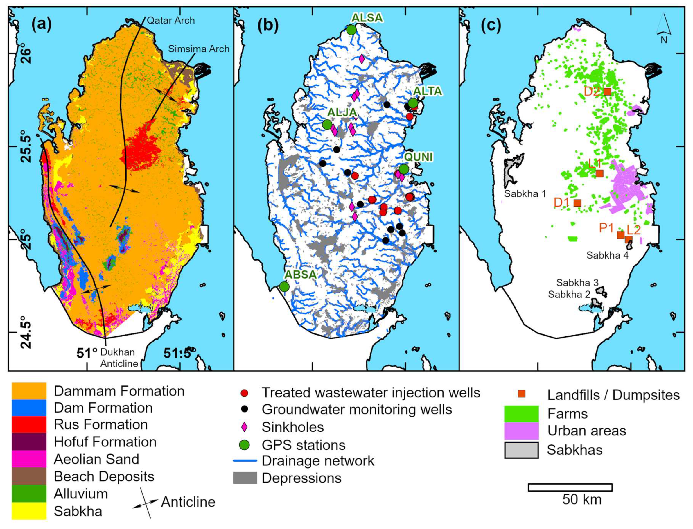
2. Study Area
3. Data and Methodology
3.1. SAR Datasets and SBAS Time Series Analysis (Step I)
3.1.1. Sentinel-1 SBAS Time Series Analysis
3.1.2. ALOS Palsar-1 SBAS Time Series Analysis
3.2. Auxiliary Datasets (Step II)
3.2.1. GPS Data
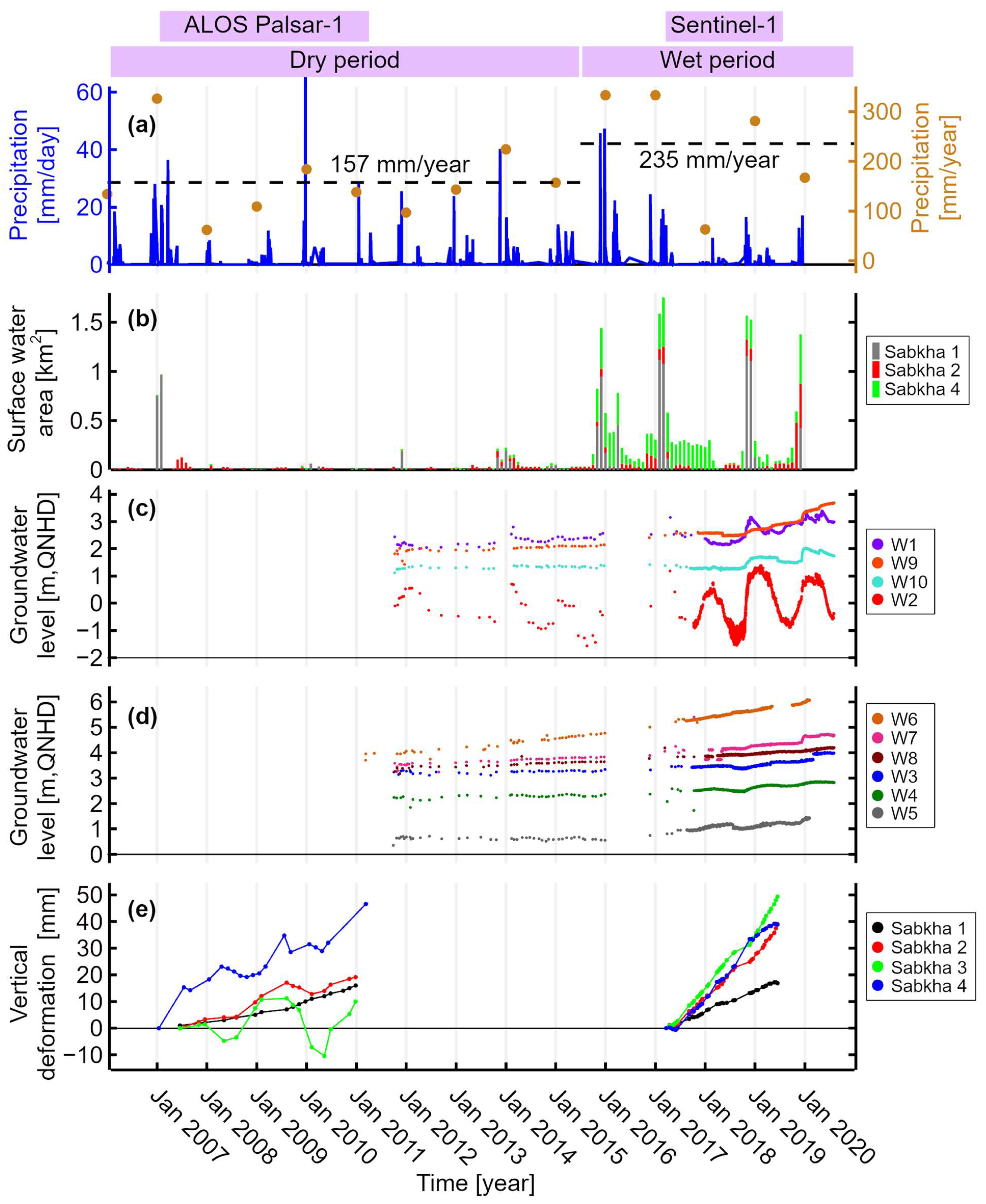
3.2.2. Precipitation Data
3.2.3. Groundwater Level Data
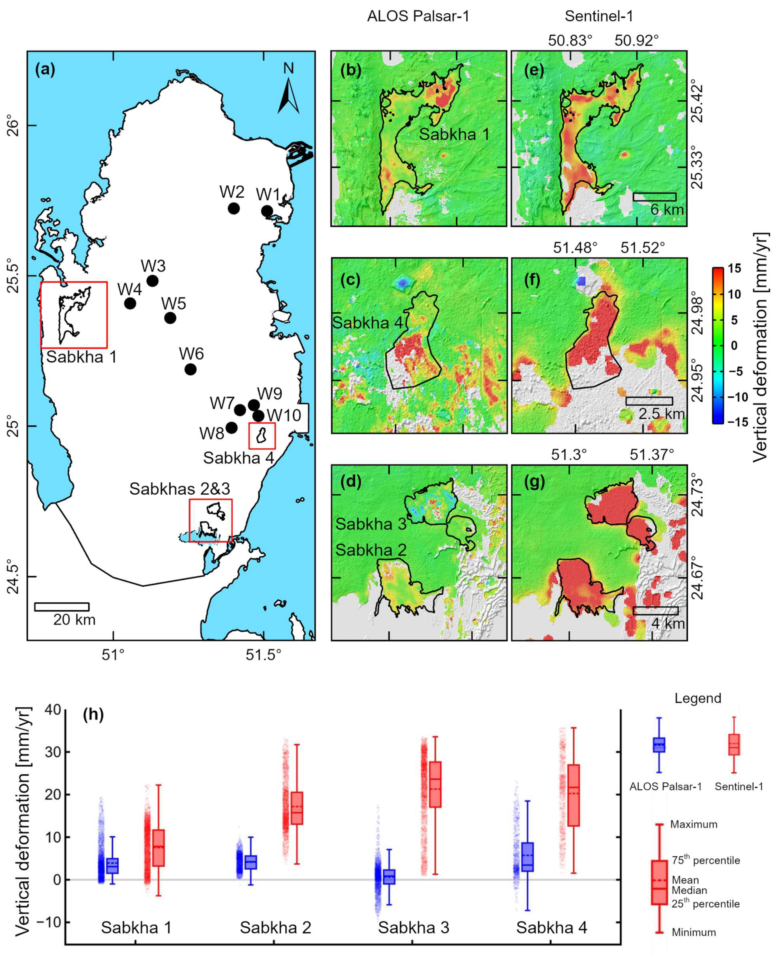
3.2.4. Surface Water Area within the Sabkhas
3.3. Spatiotemporal Correlation in a GIS Environment (Step III)
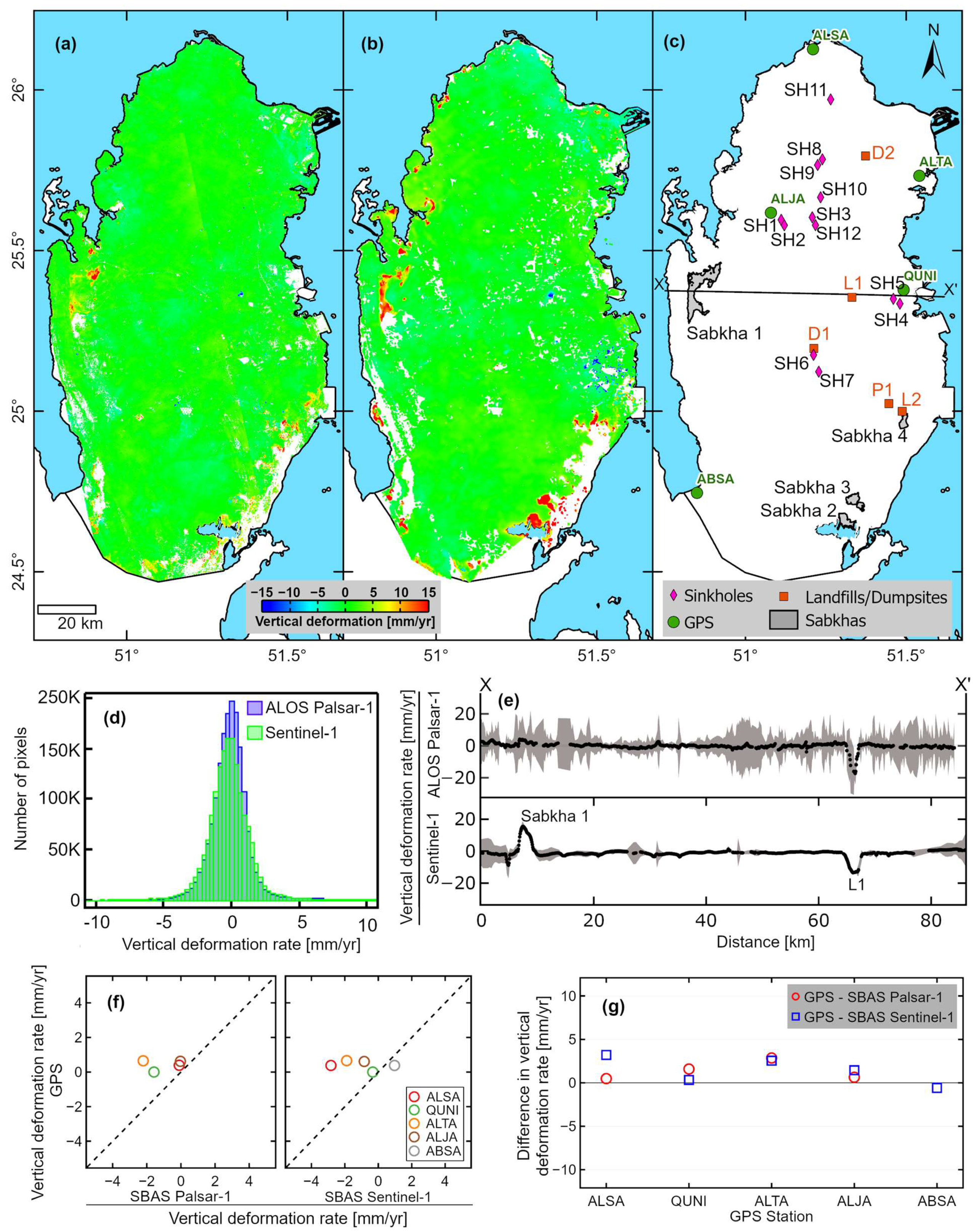
4. Results and Discussion
4.1. Uplift in Sabkhas (Salt Flats)
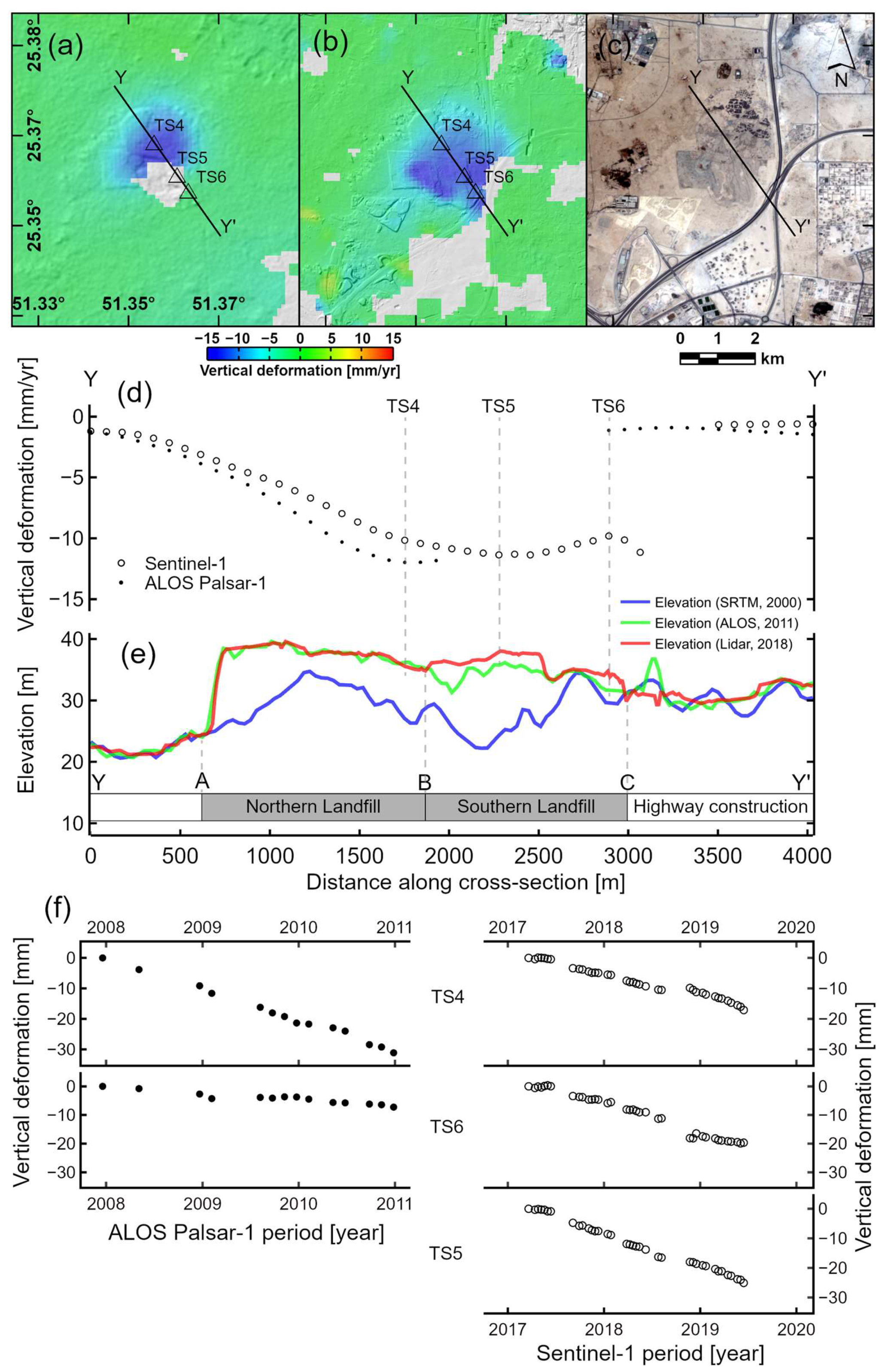
4.2. Subsidence in Umm Al-Afai Landfill
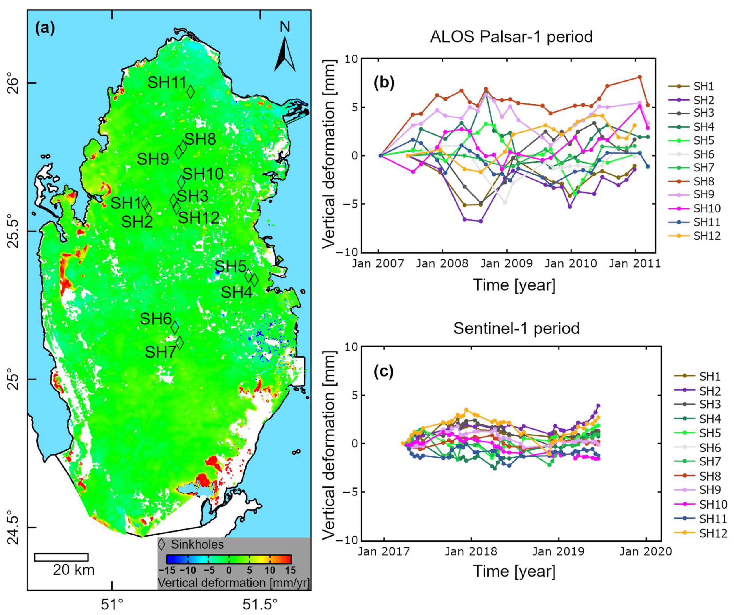
4.3. Sinkholes
4.4. Limitations
5. Conclusions
Author Contributions
Funding
Acknowledgments
Conflicts of Interest
References
- Ferretti, A.; Prati, C.; Rocca, F. Nonlinear subsidence rate estimation using permanent scatterers in differential SAR interferometry. IEEE Trans. Geosci. Remote Sens. 2000. [Google Scholar] [CrossRef]
- Hooper, A. A new method for measuring deformation on volcanoes and other natural terrains using InSAR persistent scatterers. Geophys. Res. Lett. 2004, 31, L23611. [Google Scholar] [CrossRef]
- Berardino, P.; Fornaro, G.; Lanari, R.; Sansosti, E.; Member, S.; Sansosti, E. A new algorithm for surface deformation monitoring based on small baseline differential SAR interferograms. IEEE Trans. Geosci. Remote Sens. 2002, 40, 2375–2383. [Google Scholar] [CrossRef]
- Lanari, R.; Mora, O.; Manunta, M.; Mallorqui, J.J.; Berardino, P.; Sansosti, E. A small-baseline approach for investigating deformations on full-resolution differential SAR interferograms. IEEE Trans. Geosci. Remote Sens. 2004, 42, 1377–1386. [Google Scholar] [CrossRef]
- Hooper, A. A multi-temporal InSAR method incorporating both persistent scatterer and small baseline approaches. Geophys. Res. Lett. 2008, 35, L16302. [Google Scholar] [CrossRef]
- Ferretti, A.; Fumagalli, A.; Novali, F.; Prati, C.; Rocca, F.; Rucci, A. A new algorithm for processing interferometric data-stacks: SqueeSAR. IEEE Trans. Geosci. Remote Sens. 2011, 49, 3460–3470. [Google Scholar] [CrossRef]
- van der Horst, T.; Rutten, M.M.; van de Giesen, N.C.; Hanssen, R.F. Monitoring land subsidence in Yangon, Myanmar using Sentinel-1 persistent scatterer interferometry and assessment of driving mechanisms. Remote Sens. Environ. 2018. [Google Scholar] [CrossRef]
- Aslan, G.; Cakır, Z.; Ergintav, S.; Lasserre, C.; Renard, F.; Cakir, Z.; Ergintav, S.; Lasserre, C.; Renard, F. Analysis of secular ground motions in istanbul from a long-term InSAR time-series (1992–2017). Remote Sens. 2018, 10, 408. [Google Scholar] [CrossRef]
- Gebremichael, E.; Sultan, M.; Becker, R.; El Bastawesy, M.; Cherif, O.; Emil, M. Assessing land deformation and sea encroachment in the Nile Delta: A radar interferometric and inundation modeling approach. J. Geophys. Res. Solid Earth 2018, 123, 3208–3224. [Google Scholar] [CrossRef]
- Jones, C.E.; An, K.; Blom, R.G.; Kent, J.D.; Ivins, E.R.; Bekaert, D. Anthropogenic and geologic influences on subsidence in the vicinity of New Orleans, Louisiana. J. Geophys. Res. Solid Earth 2016, 121, 3782–3803. [Google Scholar] [CrossRef]
- Kim, J.; Lu, Z. Association between localized geohazards in West Texas and human activities, recognized by Sentinel-1A/B satellite radar imagery. Sci. Rep. 2018, 1–13. [Google Scholar] [CrossRef] [PubMed]
- Baer, G.; Magen, Y.; Nof, R.N.; Raz, E.; Lyakhovsky, V.; Shalev, E. InSAR measurements and viscoelastic modeling of sinkhole precursory subsidence: Implications for sinkhole formation, early warning, and sediment properties. J. Geophys. Res. Earth Surf. 2018, 678–693. [Google Scholar] [CrossRef]
- Nof, R.N.; Abelson, M.; Raz, E.; Magen, Y.; Atzori, S.; Salvi, S.; Baer, G. SAR interferometry for sinkhole early warning and susceptibility assessment along the Dead Sea, Israel. Remote Sens. 2019, 11, 89. [Google Scholar] [CrossRef]
- Liosis, N.; Marpu, P.R.; Pavlopoulos, K.; Ouarda, T.B.M.J. Ground subsidence monitoring with SAR interferometry techniques in the rural area of Al Wagan, UAE. Remote Sens. Environ. 2018, 216, 276–288. [Google Scholar] [CrossRef]
- Othman, A.; Sultan, M.; Becker, R.; Alsefry, S.; Alharbi, T.; Gebremichael, E.; Alharbi, H.; Abdelmohsen, K. Use of geophysical and remote sensing data for assessment of aquifer depletion and related land deformation. Surv. Geophys. 2018, 39, 543–566. [Google Scholar] [CrossRef] [PubMed]
- Müller, T.; Osenbrück, K.; Strauch, G.; Pavetich, S.; Al-Mashaikhi, K.S.; Herb, C.; Merchel, S.; Rugel, G.; Aeschbach, W.; Sanford, W. Use of multiple age tracers to estimate groundwater residence times and long-term recharge rates in arid southern Oman. Appl. Geochem. 2016, 74, 67–83. [Google Scholar] [CrossRef]
- Sultan, M.; Sturchio, N.C.; Alsefry, S.; Emil, M.K.; Ahmed, M.; Abdelmohsen, K.; AbuAbdullah, M.M.; Yan, E.; Save, H.; Alharbi, T.; et al. Assessment of age, origin, and sustainability of fossil aquifers: A geochemical and remote sensing-based approach. J. Hydrol. 2019, 576, 325–341. [Google Scholar] [CrossRef]
- Dehls, J.F.; Larsen, Y.; Marinkovic, P.; Lauknes, T.R.; Stødle, D.; Moldestad, D.A. INSAR.No: A national Insar deformation mapping/monitoring service in Norway—from concept to operations. In Proceedings of the IGARSS 2019–2019 IEEE International Geoscience and Remote Sensing Symposium, Yokohama, Japan, 28 July—2 August 2019; IEEE: Piscataway, NJ, USA, 2019; pp. 5461–5464. [Google Scholar]
- Kalia, A.C.; Frei, M.; Lege, T. A Copernicus downstream-service for the nationwide monitoring of surface displacements in Germany. Remote Sens. Environ. 2017, 202, 234–249. [Google Scholar] [CrossRef]
- The Dutch Ground Motion Service WebGIS. Available online: https://bodemdalingskaart.nl/en-us/ (accessed on 26 January 2021).
- Bischoff, C.A.; Ferretti, A.; Novali, F.; Uttini, A.; Giannico, C.; Meloni, F. Nationwide deformation monitoring with SqueeSAR® using Sentinel-1 data. Proc. Int. Assoc. Hydrol. Sci. 2020, 382, 31–37. [Google Scholar] [CrossRef]
- Zinno, I.; Bonano, M.; Buonanno, S.; Casu, F.; De Luca, C.; Manunta, M.; Manzo, M.; Lanari, R. National scale surface deformation time series generation through advanced DInSAR processing of Sentinel-1 data within a cloud computing environment. IEEE Trans. Big Data 2018, 6, 558–571. [Google Scholar] [CrossRef]
- Costantini, M.; Ferretti, A.; Minati, F.; Falco, S.; Trillo, F.; Colombo, D.; Novali, F.; Malvarosa, F.; Mammone, C.; Vecchioli, F.; et al. Analysis of surface deformations over the whole Italian territory by interferometric processing of ERS, Envisat and COSMO-SkyMed radar data. Remote Sens. Environ. 2017, 202, 250–275. [Google Scholar] [CrossRef]
- Crosetto, M.; Solari, L.; Mróz, M.; Balasis-Levinsen, J.; Casagli, N.; Frei, M.; Oyen, A.; Moldestad, D.A.; Bateson, L.; Guerrieri, L.; et al. The evolution of wide-area DInSAR: From regional and national services to the European ground motion service. Remote Sens. 2020, 12, 2043. [Google Scholar] [CrossRef]
- Lanari, R.; Bonano, M.; Casu, F.; De Luca, C.; Manunta, M.; Manzo, M.; Onorato, G.; Zinno, I. Automatic generation of Sentinel-1 continental scale DInSAR deformation time series through an extended P-SBAS processing pipeline in a cloud computing environment. Remote Sens. 2020, 12, 2961. [Google Scholar] [CrossRef]
- United Nations World Population Prospects. Available online: https://population.un.org/wpp/ (accessed on 27 January 2021).
- Krupansky, J.T.; Knight, M.A.; Orndorff, R.C.; Al-Akhras, K.M.; Mouradian, A.G.; Saleh, A.F. The value of data—The Qatar Geologic Mapping Project. In Proceedings of the Geo-Congress 2019: Data, Software, Education, and Tribute to Ralph Peck, Pennsylvania, PA, USA, 24–27 March 2019; pp. 328–335. [Google Scholar]
- Ashour, M.M. Sabkhas in Qatar Peninsula. Landsc. Geodivers. 2013, 1, 10–35. [Google Scholar]
- Al-Youssef, M.; Stow, D.A.V.; West, I.M. Salt lake area, northeastern part of Dukhan Sabkha, Qatar. In Sabkha Ecosystems: Volume II: West and Central Asia; Khan, M.A., Böer, B., Kust, G.S., Barth, H.-J., Eds.; Springer: Dordrecht, The Netherlands, 2006; pp. 163–181. ISBN 978-1-4020-5072-5. [Google Scholar]
- Al-Youssef, M. Gypsum Crystals Formation and Habits, Dukhan Sabkha, Qatar. J. Earth Sci. Clim. Chang. 2015, 6. [Google Scholar] [CrossRef]
- Rosenberg, T.M.; Preusser, F.; Risberg, J.; Plikk, A.; Kadi, K.A.; Matter, A.; Fleitmann, D. Middle and Late Pleistocene humid periods recorded in palaeolake deposits of the Nafud desert, Saudi Arabia. Quat. Sci. Rev. 2013, 70, 109–123. [Google Scholar] [CrossRef]
- Sadiq, A.M.; Nasir, S.J. Middle Pleistocene karst evolution in the State of Qatar, Arabian Gulf. J. Cave Karst Stud. 2002, 64, 132–139. [Google Scholar]
- Orndorff, R.; Knight, M.; Krupansky, J.; Al-Akhras, K.; Stamm, R.; Samad, U.; Ahmed, E. Linking geology and geotechnical engineering in karst: The Qatar Geologic Mapping Project. In Proceedings of the 15th Multidisciplinary Conference on Sinkholes and the Engineering and Environmental Impacts of Karst and the 3rd Appalachian Karst Symposium, 2–6 April 2018, Shepherdstown, WV, USA.
- Planning and Statistics Authority of Qatar. Environmental statistics in State of Qatar 2017; Planning and Statistics Authority of Qatar: Doha, Qatar, 2019.
- State of Qatar. Geological Map, 1: 100 000, Sheets 2–4, State of Qatar; Industrial Development Technical Centre: Doha, Qatar, 1980. [Google Scholar]
- Fuhrmann, T.; Garthwaite, M.C. Resolving three-dimensional surface motion with InSAR: Constraints from multi-geometry data fusion. Remote Sens. 2019, 11, 241. [Google Scholar] [CrossRef]
- Yang, M.; Yang, T.; Zhang, L.; Lin, J.; Qin, X.; Liao, M. Spatio-temporal characterization of a reclamation settlement in the Shanghai coastal area with time series analyses of X-, C-, and L-band SAR datasets. Remote Sens. 2018, 10, 329. [Google Scholar] [CrossRef]
- Hanssen, R.F. Radar Interferometry: Data Interpretation and Error Analysis; Kluwer Academic Publishers: Dordrecht, The Netherlands, 2001. [Google Scholar]
- SARMAP SBAS Tutorial. Available online: http://www.sarmap.ch/tutorials/sbas_tutorial_V_2_0.pdf (accessed on 3 January 2021).
- Goldstein, R.M.; Werner, C.L. Radar interferogram filtering for geophysical applications. Geophys. Res. Lett. 1998, 25, 4035–4038. [Google Scholar] [CrossRef]
- Costantini, M.; Rosen, P.A. Generalized phase unwrapping approach for sparse data. Int. Geosci. Remote Sens. Symp. 1999, 1, 267–269. [Google Scholar] [CrossRef]
- Zumberge, J.F.; Heftin, M.B.; Jefferson, D.C.; Watkins, M.M. Precise point positioning for the efficient and robust analysis of GPS data from large networks. J. Geophys. Res. Geophys. Res. 1997, 102, 5005–5017. [Google Scholar] [CrossRef]
- Huffman, G.J.; Stocker, E.F.; Bolvin, D.T.; Nelkin, E.J.; Tan, J. GPM IMERG Final Precipitation L3 Half Hourly 0.1 Degree x 0.1 Degree V06; Goddard Earth Sciences Data and Information Services Center (GES DISC): Greenbelt, MD, USA, 2019.
- Acker, J.G.; Leptoukh, G. Online analysis enhances use of NASA Earth Science Data. Eos Trans. AGU 2007, 88, 14–17. [Google Scholar] [CrossRef]
- Al Mamoon, A.; Rahman, A. Rainfall in Qatar: Is it changing? Nat. Hazards 2017, 85, 453–470. [Google Scholar] [CrossRef]
- Lachaal, F.; Gana, S. Groundwater flow modeling for impact assessment of port dredging works on coastal hydrogeology in the area of Al-Wakrah (Qatar). Model. Earth Syst. Environ. 2016, 2, 1–15. [Google Scholar] [CrossRef]
- Gorelick, N.; Hancher, M.; Dixon, M.; Ilyushchenko, S.; Thau, D.; Moore, R. Google Earth Engine: Planetary-scale geospatial analysis for everyone. Remote Sens. Environ. 2017. [Google Scholar] [CrossRef]
- Pekel, J.F.; Cottam, A.; Gorelick, N.; Belward, A.S. High-resolution mapping of global surface water and its long-term changes. Nature 2016, 540, 418. [Google Scholar] [CrossRef] [PubMed]
- Ruch, J.; Warren, J.K.; Risacher, F.; Walter, T.R.; Lanari, R. Salt lake deformation detected from space. Earth Planet. Sci. Lett. 2012, 331–332, 120–127. [Google Scholar] [CrossRef]
- Al-Maaded, M.; Madi, N.K.; Kahraman, R.; Hodzic, A.; Ozerkan, N.G. An overview of solid waste management and plastic recycling in Qatar. J. Polym. Environ. 2012, 20, 186–194. [Google Scholar] [CrossRef]
- Sivakumar Babu, G.L.; Lakshmikanthan, P. Estimation of the components of municipal solid waste settlement. Waste Manag. Res. 2015, 33, 30–38. [Google Scholar] [CrossRef]
- Baek, W.K.; Jung, H.S.; Jo, M.J.; Lee, W.J.; Zhang, L. Ground subsidence observation of solid waste landfill park using multi-temporal radar interferometry. Int. J. Urban Sci. 2019, 23, 406–421. [Google Scholar] [CrossRef]
- Milillo, P.; Fielding, E.J.; Masi, S.; Lundgren, P.; Serio, C.; Felding, E.J.; Masi, S.; Lungren, P.; Serio, C. Monitoring municipal solid waste small magnitude landfill settlement with DinSAR. EARSeL eProceedings 2015, 25–36. [Google Scholar] [CrossRef]
- Howari, F.M.; Aldouri, R.; Sadiq, A. Gravity investigations of recent sinkholes and karst pits of Dahal Al-Hamam, State of Qatar. Environ. Earth Sci. 2016, 75, 440. [Google Scholar] [CrossRef]
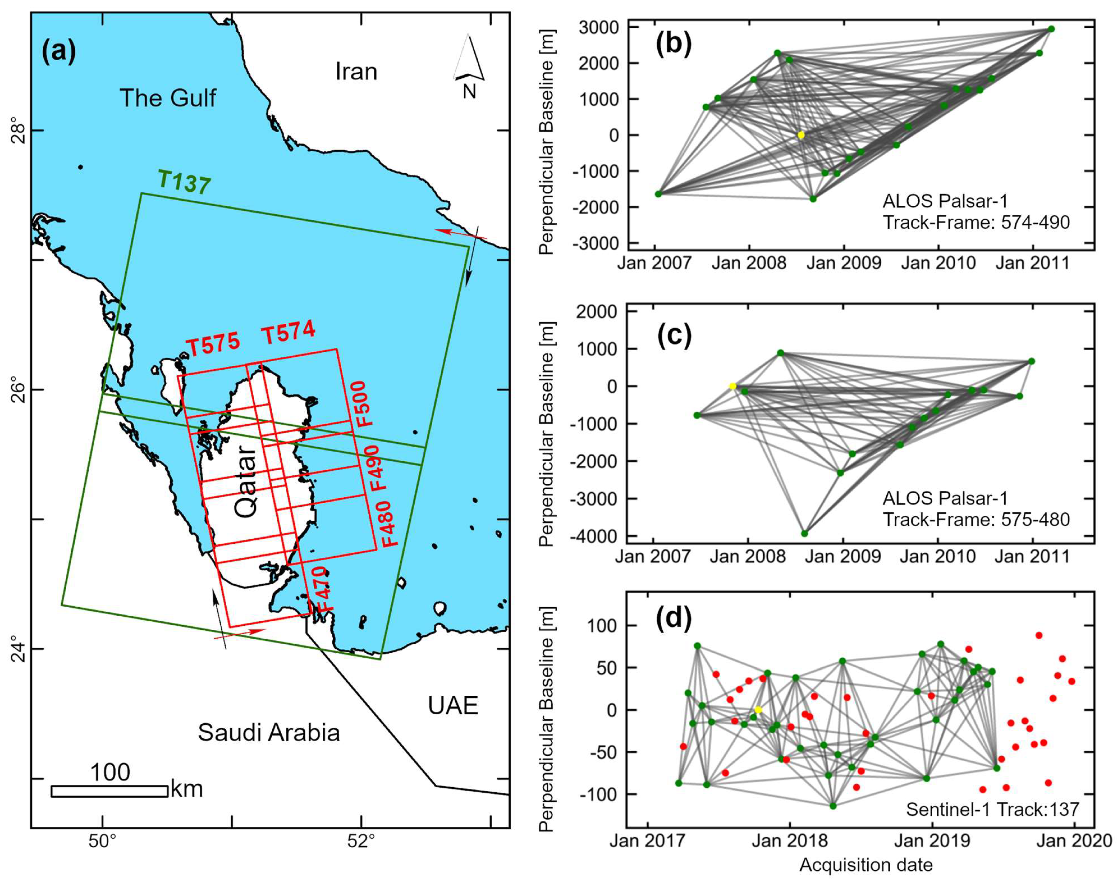
| SAR Instrument | Orbit Type | Track | Frame | No. of Images | No. of Pairs | Perpendicular Baseline (m) | Temporal Baseline (Days) | No. of Connection Per Image | ||||
|---|---|---|---|---|---|---|---|---|---|---|---|---|
| Mean | Max | Mean | Max | Mean | Min | Max | ||||||
| ALOS Palsar-1 | Ascending | 574 | 480 | 19 | 167 | 1521 | 4552 | 470 | 1518 | 17.6 | 15 | 18 |
| ALOS Palsar-1 | Ascending | 574 | 490 * | 21 | 204 | 1542 | 4579 | 504 | 1518 | 19.4 | 16 | 20 |
| ALOS Palsar-1 | Ascending | 574 | 500 | 22 | 225 | 1525 | 4613 | 506 | 1518 | 20.4 | 17 | 21 |
| ALOS Palsar-1 | Ascending | 575 | 470 | 15 | 99 | 1201 | 3888 | 483 | 1288 | 13.2 | 8 | 14 |
| ALOS Palsar-1 | Ascending | 575 | 480 * | 16 | 114 | 1184 | 3934 | 468 | 1288 | 14.2 | 9 | 15 |
| ALOS Palsar-1 | Ascending | 575 | 490 | 16 | 113 | 1243 | 3862 | 446 | 1288 | 14.2 | 8 | 15 |
| ALOS Palsar-1 | Ascending | 575 | 500 | 16 | 114 | 1273 | 3995 | 427 | 1150 | 14.2 | 9 | 15 |
| Sentinel-1 | Descending | 137 * | 37 | 177 | 47 | 121 | 82 | 324 | 9.6 | 5 | 14 | |
| Sinkhole Label | Name/Locality | Elevation (m, NHD) | Latitude | Longitude | ALOS Palsar-1 SBAS | Sentinel-1 SBAS | ||
|---|---|---|---|---|---|---|---|---|
| Velocity (mm/yr) | RMS (mm) | Velocity (mm/yr) | RMS (mm) | |||||
| SH1 | Al Jumayliyah-1 | 48 | 51.111073 | 25.595563 | 0.0 | 8.0 | −0.1 | 1.5 |
| SH2 | Al Jumayliyah-2 | 48 | 51.120787 | 25.578551 | 0.0 | 12.6 | 0.7 | 0.9 |
| SH3 | At Turiyah-1 | 39 | 51.207754 | 25.603423 | 1.6 | 7.8 | −0.1 | 2.0 |
| SH4 | Dahl Al Hamam | 10 | 51.48044 | 25.33448 | −0.2 | 9.1 | 0.5 | 2.2 |
| SH5 | Dahl Duhail | 15 | 51.460115 | 25.349574 | −1.1 | 6.1 | 0.3 | 0.6 |
| SH6 | Dahl Musfer | 41 | 51.211746 | 25.175002 | 0.2 | 3.5 | −0.6 | 0.9 |
| SH7 | Dahl Mudhlem | 42 | 51.228019 | 25.122733 | 0.3 | 1.0 | −0.1 | 1.0 |
| SH8 | Al Ghuwayriyah-2 | 28 | 51.239251 | 25.783997 | 0.8 | 2.8 | 0.1 | 0.1 |
| SH9 | Al Ghuwayriyah-1 | 31 | 51.224483 | 25.766165 | 0.4 | 4.5 | −0.1 | 0.7 |
| SH10 | At Turiyah-3 | 32 | 51.233704 | 25.665716 | 0.8 | 2.5 | −0.9 | 0.6 |
| SH11 | Al Ghosheimah-1 | 15 | 51.265078 | 25.970297 | −0.5 | 1.7 | 0.0 | 1.1 |
| SH12 | At Turiyah-2 | 44 | 51.217722 | 25.578993 | 1.7 | 2.0 | −0.1 | 4.1 |
Publisher’s Note: MDPI stays neutral with regard to jurisdictional claims in published maps and institutional affiliations. |
© 2021 by the authors. Licensee MDPI, Basel, Switzerland. This article is an open access article distributed under the terms and conditions of the Creative Commons Attribution (CC BY) license (http://creativecommons.org/licenses/by/4.0/).
Share and Cite
Emil, M.K.; Sultan, M.; Alakhras, K.; Sataer, G.; Gozi, S.; Al-Marri, M.; Gebremichael, E. Countrywide Monitoring of Ground Deformation Using InSAR Time Series: A Case Study from Qatar. Remote Sens. 2021, 13, 702. https://doi.org/10.3390/rs13040702
Emil MK, Sultan M, Alakhras K, Sataer G, Gozi S, Al-Marri M, Gebremichael E. Countrywide Monitoring of Ground Deformation Using InSAR Time Series: A Case Study from Qatar. Remote Sensing. 2021; 13(4):702. https://doi.org/10.3390/rs13040702
Chicago/Turabian StyleEmil, Mustafa Kemal, Mohamed Sultan, Khaled Alakhras, Guzalay Sataer, Sabreen Gozi, Mohammed Al-Marri, and Esayas Gebremichael. 2021. "Countrywide Monitoring of Ground Deformation Using InSAR Time Series: A Case Study from Qatar" Remote Sensing 13, no. 4: 702. https://doi.org/10.3390/rs13040702
APA StyleEmil, M. K., Sultan, M., Alakhras, K., Sataer, G., Gozi, S., Al-Marri, M., & Gebremichael, E. (2021). Countrywide Monitoring of Ground Deformation Using InSAR Time Series: A Case Study from Qatar. Remote Sensing, 13(4), 702. https://doi.org/10.3390/rs13040702


