
A Consumer Grade UAV-Based Framework to Estimate Structural Attributes of Coppice and High Oak Forest Stands in Semi-Arid Regions


Abstract
:1. Introduction
- -
- Are 3D photogrammetric models accurate enough to estimate the height of single trees in Zagros?
- -
- Can DBH (as an essential variable that is unable to be directly derived from photogrammetric models) be estimated using other UAV-measured primary attributes?
- -
- How do the available single-attribute allometric equations for Q. brantii in Zagros Forests perform compared to commonly-applied nonlinear models (RFR) on UAV-extracted variables to predict AGB?
2. Materials and Methods
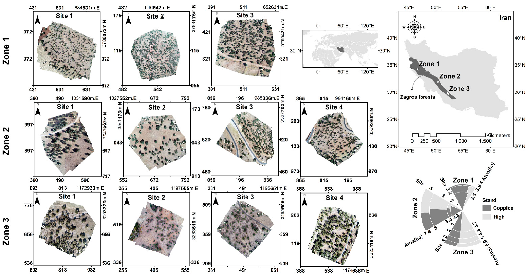
2.1. Study Area
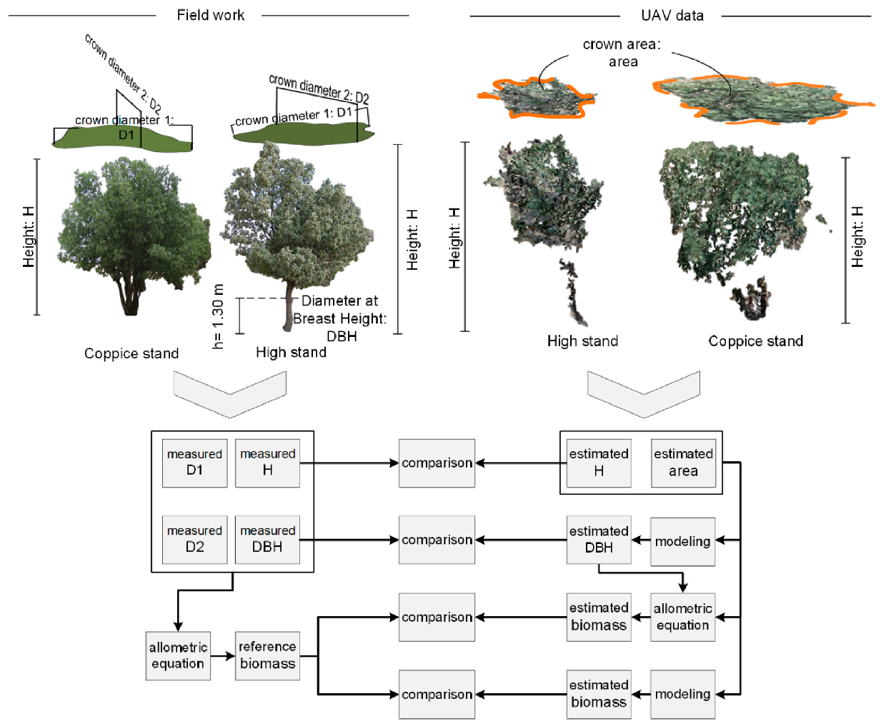
2.2. Field Measurements
2.3. UAV Imaging
2.4. Methodology
2.4.1. UAV-Derived Terrain and Surface Models
2.4.2. Individual Tree Crown Segmentation
2.4.3. Extracting the Height and Canopy Area of Individual Trees
2.4.4. DBH Estimation
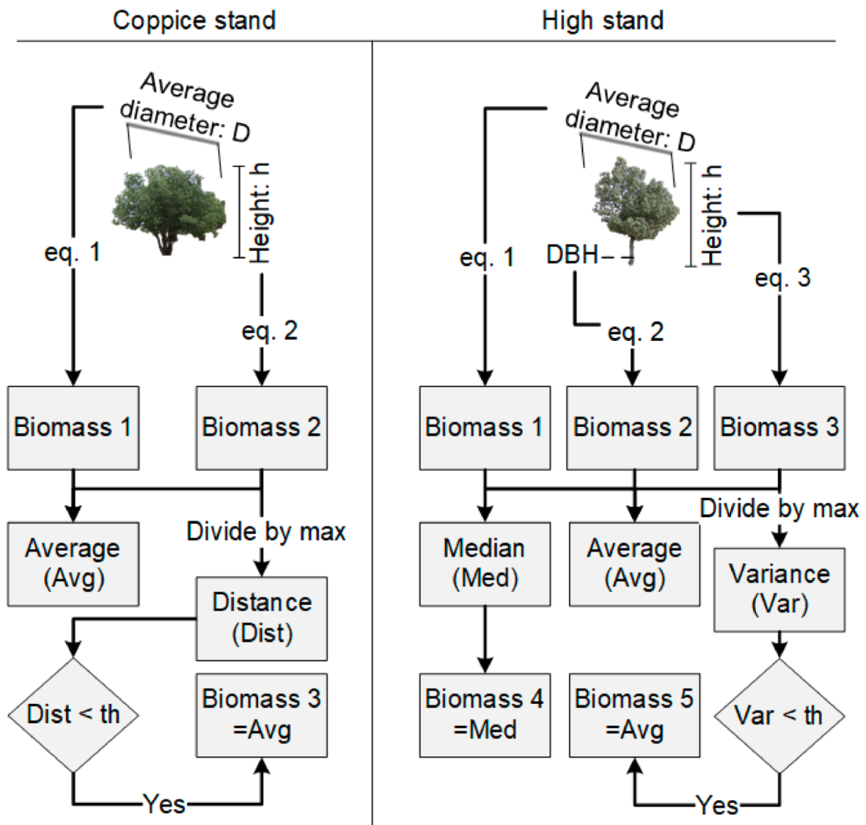
2.4.5. AGB Estimation
3. Results
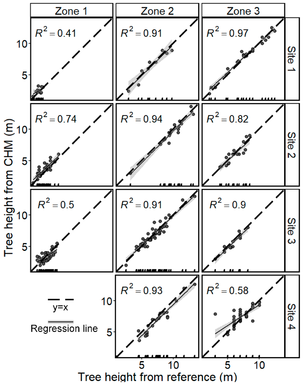
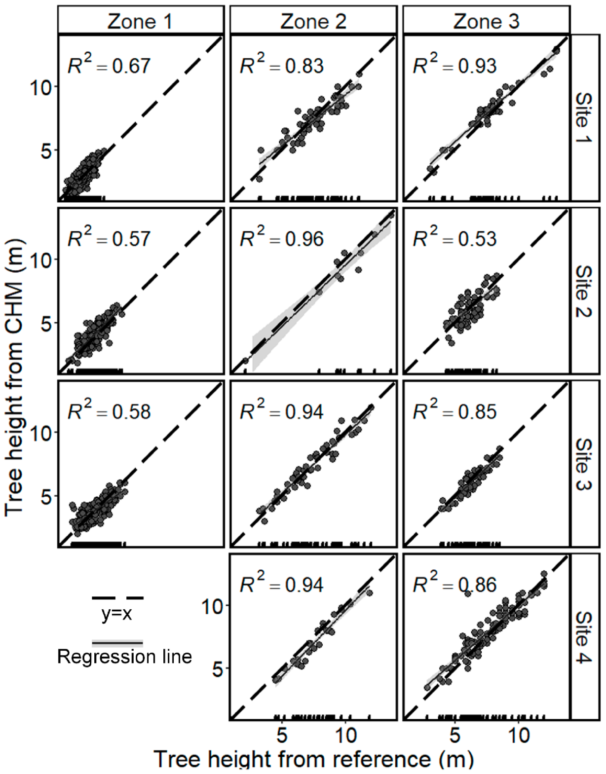
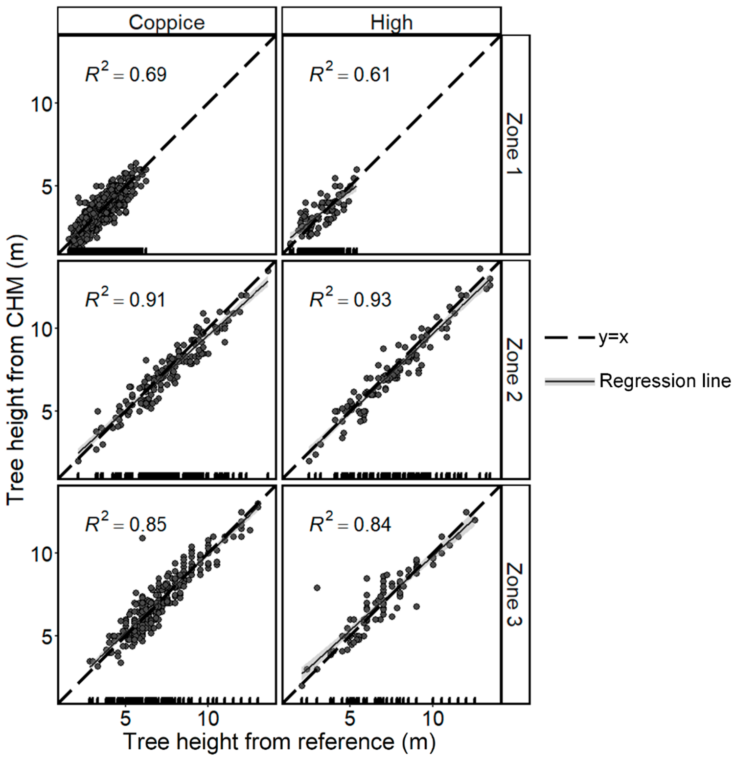
3.1. Tree Height Estimation
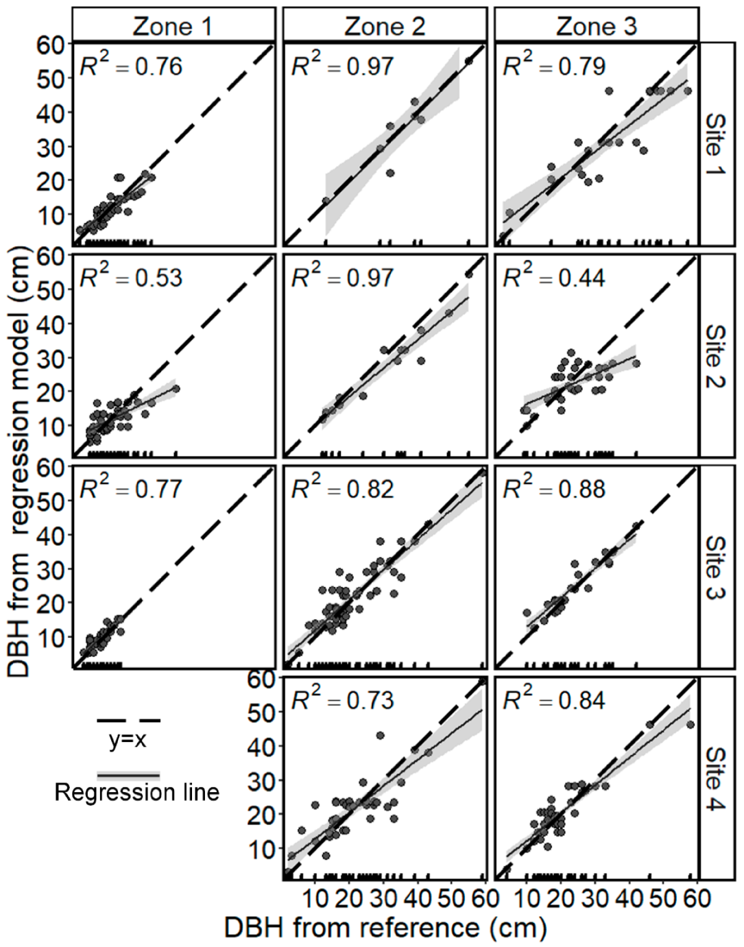
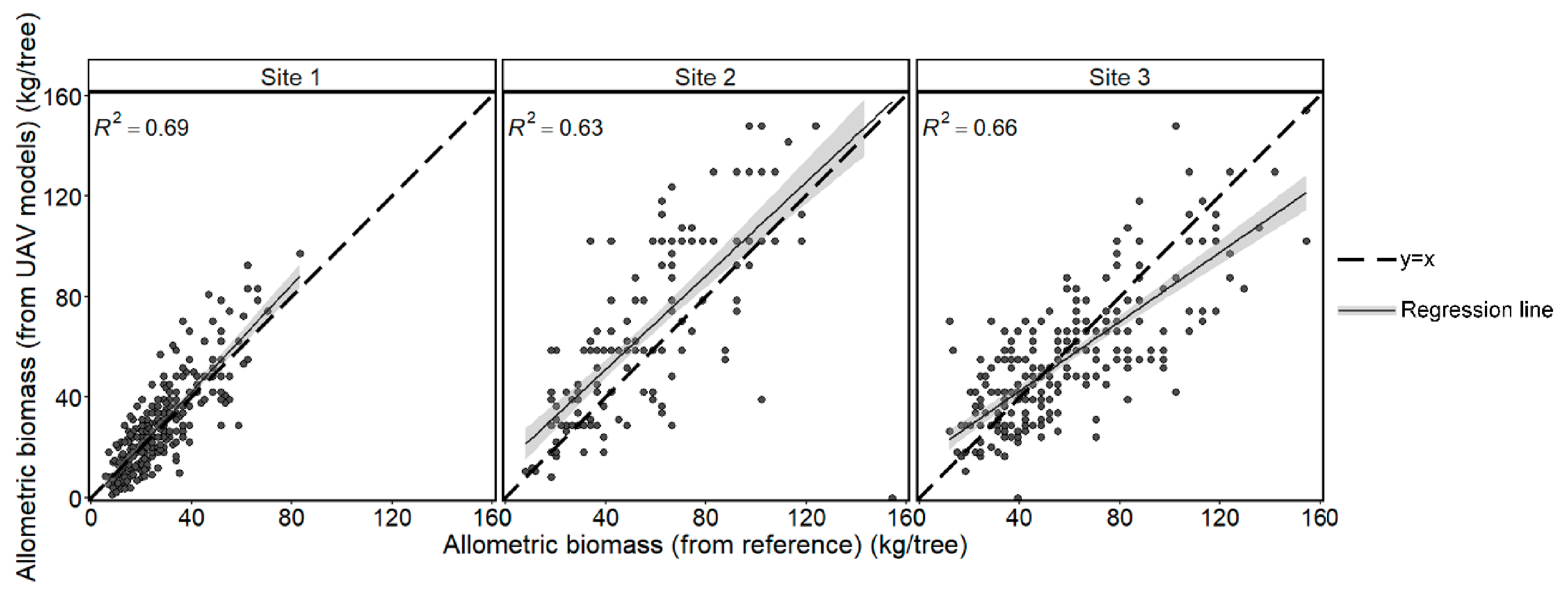
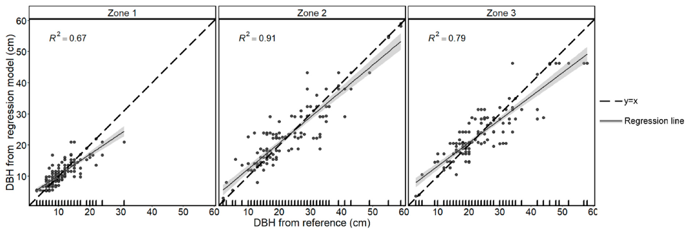
3.2. DBH Estimation
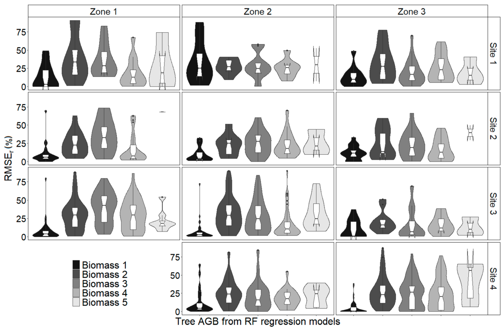
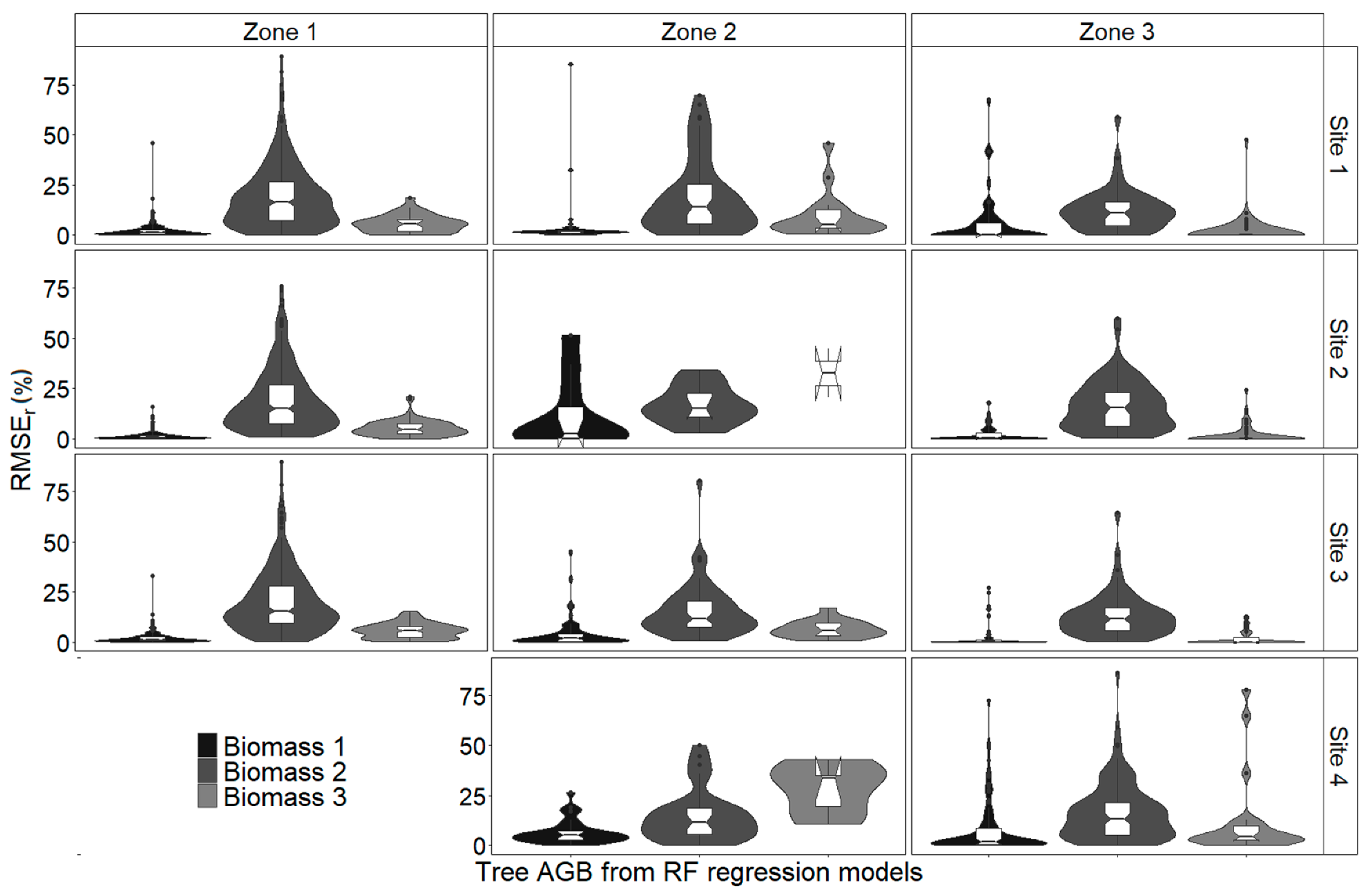
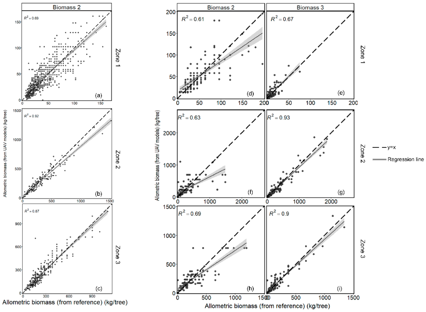
3.3. AGB Estimation
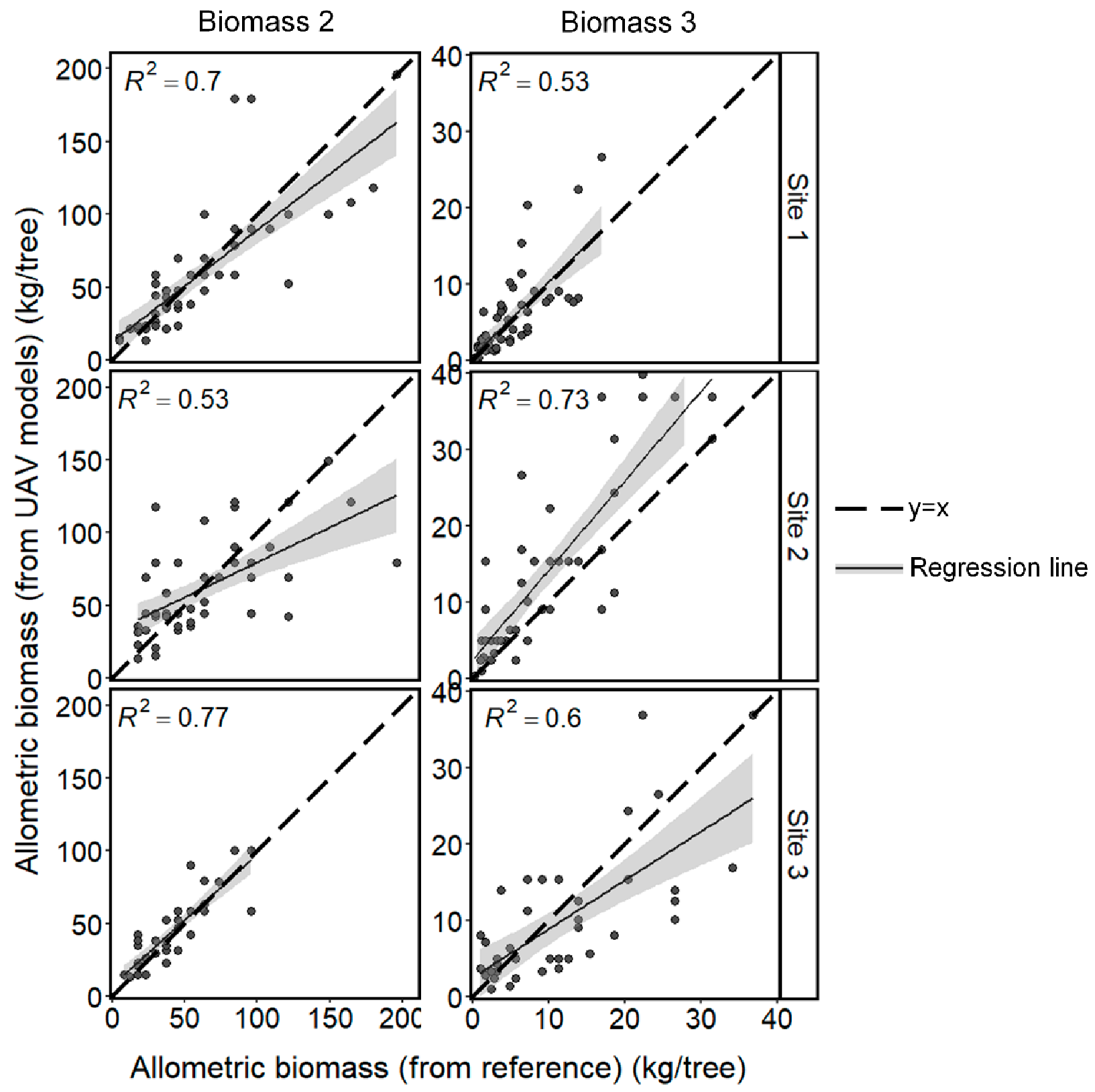
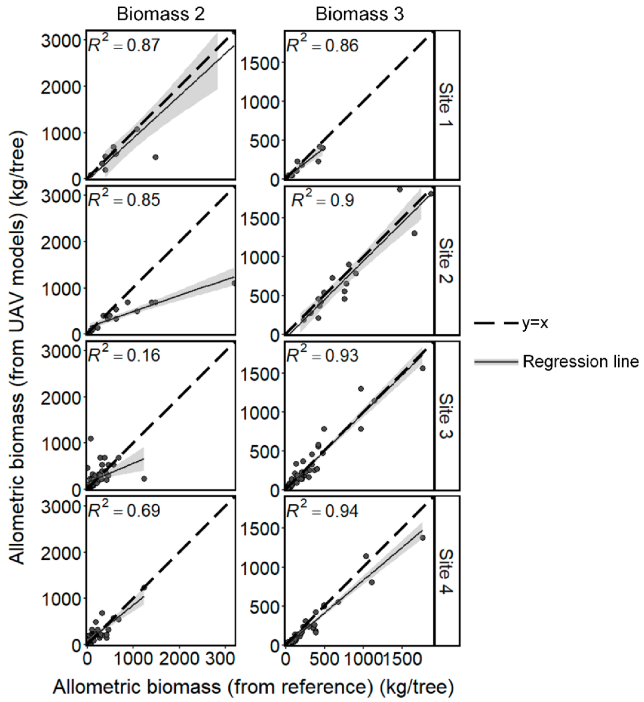
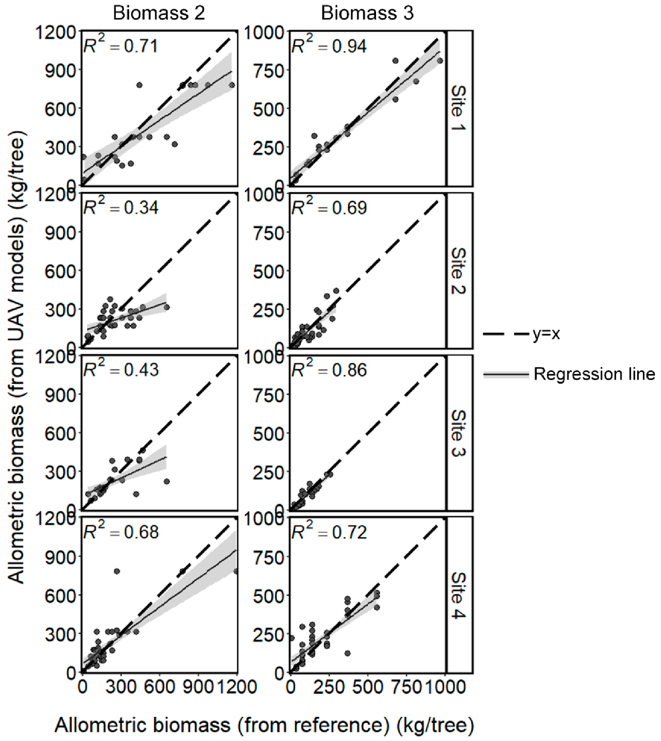
3.3.1. AGB estimation by allometric equations
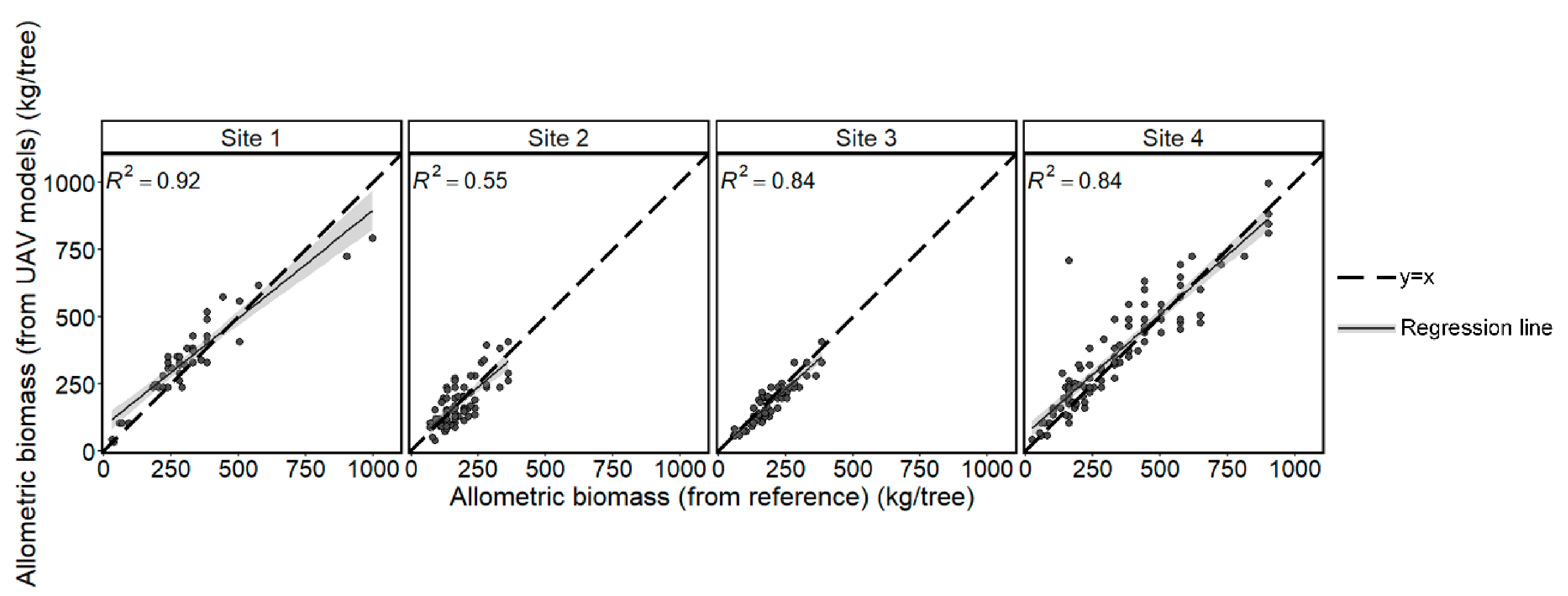
3.3.2. AGB Estimation by RFR
4. Discussion
5. Conclusions
Author Contributions
Funding
Data Availability Statement
Acknowledgments
Conflicts of Interest
Appendix A
Appendix B
Appendix C

Appendix D
References
- Quéré, C.L.; Andrew, R.M.; Canadell, J.G.; Sitch, S.; Korsbakken, J.I.; Peters, G.P.; Manning, A.C.; Boden, T.A.; Tans, P.P.; Houghton, R.A. Global Carbon Budget 2016. Earth Syst. Sci. Data 2016, 8, 605–649. [Google Scholar] [CrossRef]
- Kint, V.; Robert, D.W.; Noël, L. Evaluation of sampling methods for the estimation of structural indices in forest stands. Ecol. Model. 2004, 180, 461–476. [Google Scholar] [CrossRef]
- Nowak, D.J.; Crane, D.E.; Stevens, J.C.; Hoehn, R.E.; Walton, J.T.; Bond, J. A ground-based method of assessing urban forest structure and ecosystem services. Aboriculture Urban For. 2008, 34, 347–358. [Google Scholar]
- Jung, J.; Kim, S.; Hong, S.; Kim, K.; Kim, E.; Im, J.; Heo, J. Effects of national forest inventory plot location error on forest carbon stock estimation using k-nearest neighbor algorithm. ISPRS J. Photogramm. Remote Sens. 2013, 81, 82–92. [Google Scholar] [CrossRef]
- Iizuka, K.; Tateishi, R. Estimation of CO2 Sequestration by the forests in Japan by discriminating precise tree age category using remote sensing techniques. Remote Sens. 2015, 7, 15082–15113. [Google Scholar] [CrossRef]
- Rana, P.; Korhonen, L.; Gautam, B.; Tokola, T. Effect of field plot location on estimating tropical forest above-ground bi-omass in Nepal using airborne laser scanning data. ISPRS J. Photogramm. Remote Sens. 2014, 94, 55–62. [Google Scholar] [CrossRef]
- Garcia, M.; Saatchi, S.; Ustin, S.; Balzter, H. Modelling Forest canopy height by integrating airborne LiDAR samples with satellite Radar and multispectral imagery. Int. J. Appl. Earth Obs. Geoinf. 2018, 66, 159–173. [Google Scholar] [CrossRef]
- Goodbody, T.R.; Coops, N.C.; Marshall, P.L.; Tompalski, P.; Crawford, P. Unmanned aerial systems for precision forest in-ventory purposes: A review and case study. For. Chron. 2017, 93, 71–81. [Google Scholar] [CrossRef]
- Ganz, S.; Käber, Y.; Adler, P. Measuring Tree height with remote sensing—A comparison of photogrammetric and lidar data with different field measurements. Forests 2019, 10, 694. [Google Scholar] [CrossRef]
- Phalla, T.; Ota, T.; Mizoue, N.; Kajisa, T.; Yoshida, S.; Vuthy, M.; Heng, S. The importance of tree height in estimating indi-vidual tree biomass while considering errors in measurements and allometric models. AGRIVITA J. Agric. Sci. 2017, 40, 131–140. [Google Scholar]
- Kebede, B.; Soromessa, T. Allometric equations for aboveground biomass estimation of Olea Europaea L. subsp. cuspidata in Mana Angetu Forest. Ecosyst. Health Sustain. 2018, 4, 1–12. [Google Scholar] [CrossRef]
- Chave, J.; Andalo, C.; Brown, S.; Cairns, M.A.; Chambers, J.; Eamus, D.; Fölster, H.; Fromard, F.; Higuchi, N.; Kira, T.; et al. Tree allometry and improved estimation of carbon stocks and balance in tropical forests. Oecologia 2005, 145, 87–99. [Google Scholar] [CrossRef]
- Andersen, H.-E.; Reutebuch, S.E.; McGaughey, R.J. A rigorous assessment of tree height measurements obtained using airborne lidar and conventional field methods. Can. J. Remote Sens. 2006, 32, 355–366. [Google Scholar] [CrossRef]
- Liu, G.; Wang, J.; Dong, P.; Chen, Y.; Liu, Z. Estimating Individual Tree Height and Diameter at Breast Height (DBH) from Terrestrial Laser Scanning (TLS) Data at Plot Level. Forests 2018, 9, 398. [Google Scholar] [CrossRef]
- Fieber, K.D.; Davenport, I.; Tanase, M.A.; Ferryman, J.M.; Gurney, R.J.; Becerra, V.M.; Walker, J.; Hacker, J.M. Validation of Canopy Height Profile methodology for small-footprint full-waveform airborne LiDAR data in a discontinuous canopy environment. ISPRS J. Photogramm. Remote Sens. 2015, 104, 144–157. [Google Scholar] [CrossRef]
- Nilsson, M. Estimation of tree heights and stand volume using an airborne lidar system. Remote Sens. Environ. 1996, 56, 1–7. [Google Scholar] [CrossRef]
- Naesset, E. Estimating Timber Volume of Forest Stands Using Airborne Laser Scanner Data. Remote Sens. Environ. 1997, 61, 246–253. [Google Scholar] [CrossRef]
- Magnussen, S.; Boudewyn, P. Derivations of stand heights from airborne laser scanner data with canopy-based quantile estimators. Can. J. For. Res. 1998, 28, 1016–1031. [Google Scholar] [CrossRef]
- Panagiotidis, D.; Abdollahnejad, A.; Surový, P.; Chiteculo, V. Determining tree height and crown diameter from high-resolution UAV imagery. Int. J. Remote Sens. 2017, 38, 2392–2410. [Google Scholar] [CrossRef]
- Falkowski, M.J.; Smith, A.; Hudak, A.T.; Gessler, P.E.; Vierling, L.A.; Crookston, N.L. Automated estimation of individual conifer tree height and crown diameter via two-dimensional spatial wavelet analysis of lidar data. Can. J. Remote Sens. 2006, 32, 153–161. [Google Scholar] [CrossRef]
- Camarretta, N.; Harrison, P.; Bailey, T.; Potts, B.; Lucieer, A.; Davidson, N.; Hunt, M. Monitoring Forest structure to guide adaptive management of forest restoration: A review of remote sensing approaches. New For. 2020, 51, 573–596. [Google Scholar] [CrossRef]
- Vauhkonen, J.; Maltamo, M.; McRoberts, R.E.; Næsset, E. Introduction to forestry applications of airborne laser scanning. Concepts Case Studies. Manag. For. Ecosyst. 2014, 27, 2014. [Google Scholar]
- Kaartinen, H.; Hyyppä, J.; Yu, X.; Vastaranta, M.; Hyyppä, H.; Kukko, A.; Holopainen, M.; Heipke, C.; Hirschmugl, M.; Morsdorf, F.; et al. An international comparison of individual tree detection and extraction using airborne laser scanning. Remote Sens. 2012, 4, 950–974. [Google Scholar] [CrossRef]
- Luo, H.; Chen, E.; Cheng, J.; Li, X. Forest height estimation methods using polarimetric SAR Interferometry. J. Remote Sens. 2010, 14, 806–821. [Google Scholar]
- Pohl, C.; Loong, C. In-Situ Data Collection for Oil Palm Tree Height Determination Using Synthetic Aperture Radar; IOP Publishing: Bistol, UK, 2016; Volume 34, p. 01 2027.
- Goodbody, T.R.; Coops, N.C.; White, J.C. Digital aerial photogrammetry for updating area-based forest inventories: A review of opportunities, challenges, and future directions. Curr. For. Rep. 2019, 5, 55–75. [Google Scholar] [CrossRef]
- Puliti, S.; Solberg, S.; Granhus, A. Use of UAV Photogrammetric data for estimation of biophysical properties in forest stands under regeneration. Remote Sens. 2019, 11, 233. [Google Scholar] [CrossRef]
- Krause, S.; Sanders, T.G.; Mund, J.-P.; Greve, K. UAV-based photogrammetric tree height measurement for intensive forest monitoring. Remote Sens. 2019, 11, 758. [Google Scholar] [CrossRef]
- Pádua, L.; Vanko, J.; Hruška, J.; Adão, T.; Sousa, J.J.; Peres, E.; Morais, R. UAS, sensors, and data processing in agroforestry: A review towards practical applications. Int. J. Remote Sens. 2017, 38, 2349–2391. [Google Scholar] [CrossRef]
- Gómez, C.; Alejandro, P.; Hermosilla, T.; Montes, F.; Pascual, C.; Ruiz, L.A.; Álvarez-Taboada, F.; Tanase, M.; Valbuena, R. Remote sensing for the Spanish forests in the 21st century: A review of advances, needs, and opportunities. For. Syst. 2019, 28, 1–33. [Google Scholar] [CrossRef]
- Lisein, J.; Pierrot-Deseilligny, M.; Bonnet, S.; Lejeune, P. A Photogrammetric workflow for the creation of a forest canopy height model from small unmanned aerial system imagery. Forests 2013, 4, 922–944. [Google Scholar] [CrossRef]
- Zarco-Tejada, P.J.; Diaz-Varela, R.; Angileri, V.; Loudjani, P. Tree height quantification using very high resolution imagery acquired from an Unmanned Aerial Vehicle (UAV) and Automatic 3D photo-reconstruction methods. Eur. J. Agron. 2014, 55, 89–99. [Google Scholar] [CrossRef]
- Dandois, J.P.; Ellis, E.C. High Spatial Resolution Three-dimensional mapping of vegetation spectral dynamics using computer vision. Remote Sens. Environ. 2013, 136, 259–276. [Google Scholar] [CrossRef]
- Liang, X.; Kankare, V.; Hyyppä, J.; Wang, Y.; Kukko, A.; Haggrén, H.; Yu, X.; Kaartinen, H.; Jaakkola, A.; Guan, F. Terrestrial Laser Scanning in Forest Inventories. ISPRS J. Photogramm. Remote Sens. 2016, 115, 63–77. [Google Scholar] [CrossRef]
- Liu, C.; Xing, Y.; Duanmu, J.; Tian, X. Evaluating different methods for estimating diameter at breast height from terrestrial laser scanning. Remote Sens. 2018, 10, 513. [Google Scholar] [CrossRef]
- US Department of Agriculture Forest Service (USDA FS). Forest Inventory and Analysis National Core Field Guide; Field Data Collection Procedures for Phase 2 Plots; USDA FS: Washington, DC, USA, 2017; Volume 1. [Google Scholar]
- Iizuka, K.; Yonehara, T.; Itoh, M.; Kosugi, Y. Estimating tree height and diameter at breast height (DBH) from digital sur-face models and orthophotos obtained with an unmanned aerial system for a Japanese cypress (Chamaecyparis Obtusa) Forest. Remote Sens. 2018, 10, 13. [Google Scholar] [CrossRef]
- Hyyppä, J.; Yu, X.; Hyyppä, H.; Vastaranta, M.; Holopainen, M.; Kukko, A.; Kaartinen, H.; Jaakkola, A.; Vaaja, M.; Koskinen, J.; et al. Advances in Forest Inventory Using Airborne Laser Scanning. Remote Sens. 2012, 4, 1190–1207. [Google Scholar] [CrossRef]
- Widyorini, R.; Kobayashi, S.; Kawai, S.; Omura, Y.; Sanga-Ngoie, K.; Supriadi, B. Backscattering characteristics of L-band polarimetric and optical satellite imagery over planted acacia forests in Sumatra, Indonesia. J. Appl. Remote Sens. 2012, 6, 063525. [Google Scholar] [CrossRef]
- Ota, T.; Ogawa, M.; Shimizu, K.; Kajisa, T.; Mizoue, N.; Yoshida, S.; Takao, G.; Hirata, Y.; Furuya, N.; Sano, T.; et al. Aboveground biomass estimation using structure from motion approach with aerial photographs in a seasonal tropical forest. Forests 2015, 6, 3882–3898. [Google Scholar] [CrossRef]
- Corte, A.P.D.; Rex, F.E.; De Almeida, D.R.A.; Sanquetta, C.R.; Silva, C.A.; Moura, M.M.; Wilkinson, B.; Zambrano, A.M.A.; Neto, E.M.D.C.; Veras, H.F.P.; et al. Measuring individual tree diameter and height using GatorEye High-Density UAV-Lidar in an Integrated Crop-Livestock-Forest System. Remote Sens. 2020, 12, 863. [Google Scholar] [CrossRef]
- Puliti, S.; Breidenbach, J.; Astrup, R. Estimation of Forest Growing Stock Volume with UAV Laser Scanning Data: Can It Be Done without Field Data? Remote Sens. 2020, 12, 1245. [Google Scholar] [CrossRef]
- Machimura, T.; Fujimoto, A.; Hayashi, K.; Takagi, H.; Sugita, S. A novel tree biomass estimation model applying the pipe model theory and adaptable to UAV-Derived Canopy Height Models. Forests 2021, 12, 258. [Google Scholar] [CrossRef]
- Jucker, T.; Caspersen, J.; Chave, J.; Antin, C.; Barbier, N.; Bongers, F.; Dalponte, M.; van Ewijk, K.Y.; Forrester, D.I.; Haeni, M. Allometric Equations for Integrating Remote Sensing Imagery into Forest Monitoring Programmes. Glob. Chang. Biol. 2017, 23, 177–190. [Google Scholar] [CrossRef]
- Zagalikis, G.; Cameron, A.D.; Miller, D.R. The application of digital photogrammetry and image analysis techniques to derive tree and stand characteristics. Can. J. For. Res. 2005, 35, 1224–1237. [Google Scholar] [CrossRef]
- Fraser, B.; Congalton, R. Estimating Primary Forest Attributes and Rare Community Characteristics Using Unmanned Aerial Systems (UAS): An Enrichment of Conventional Forest Inventories. Remote Sens. 2021, 13, 2971. [Google Scholar] [CrossRef]
- Chisholm, R.; Rodríguez-Ronderos, M.; Lin, F. Estimating Tree Diameters from an Autonomous Below-Canopy UAV with Mounted LiDAR. Remote Sens. 2021, 13, 2576. [Google Scholar] [CrossRef]
- Baker, T.R.; Phillips, O.L.; Malhi, Y.; Almeida, S.; Arroyo, L.; Di Fiore, A.; Erwin, T.; Killeen, T.J.; Laurance, S.G.; Laurance, W.F.; et al. Variation in wood density determines spatial patterns inAmazonian forest biomass. Glob. Chang. Biol. 2004, 10, 545–562. [Google Scholar] [CrossRef]
- Lewis, S.L.; Sonké, B.; Sunderland, T.; Begne, S.K.; Lopez-Gonzalez, G.; Van Der Heijden, G.M.; Phillips, O.L.; Affum-Baffoe, K.; Baker, T.R.; Banin, L. Above-Ground Biomass and Structure of 260 African Tropical Forests. Philos. Trans. R. Soc. B Biol. Sci. 2013, 368, 20120295. [Google Scholar] [CrossRef]
- Brahma, B.; Nath, A.J.; Sileshi, G.W.; Das, A.K. Estimating biomass stocks and potential loss of biomass carbon through clear-felling of rubber plantations. Biomass Bioenergy 2018, 115, 88–96. [Google Scholar] [CrossRef]
- Chave, J.; Condit, R.; Aguilar, S.; Hernandez, A.; Lao, S.; Perez, R. Error propagation and scaling for tropical forest biomass estimates. Philos. Trans. R. Soc. B Biol. Sci. 2004, 359, 409–420. [Google Scholar] [CrossRef]
- Pothong, T.; Elliott, S.; Chairuangsri, S.; Chanthorn, W.; Shannon, D.P.; Wangpakapattanawong, P. New Allometric Equations for Quantifying Tree Biomass and Carbon Sequestration in Seasonally Dry Secondary Forest in Northern Thailand. New Forests 2021, 1–20. [Google Scholar] [CrossRef]
- Kraus, K.; Pfeifer, N. Determination of terrain models in wooded areas with airborne laser scanner data. ISPRS J. Photogramm. Remote Sens. 1998, 53, 193–203. [Google Scholar] [CrossRef]
- Vosselman, G. Slope based filtering of laser altimetry data. Int. Arch. Photogramm. Remote Sens. 2000, 33, 935–942. [Google Scholar]
- Sithole, G.; Vosselman, G. Experimental comparison of filter algorithms for bare-Earth extraction from airborne laser scanning point clouds. ISPRS J. Photogramm. Remote Sens. 2004, 59, 85–101. [Google Scholar] [CrossRef]
- Bandara, K.R.; Samarakoon, L.; Shrestha, R.P.; Kamiya, Y. Automated generation of digital terrain model using point clouds of digital surface model in forest area. Remote Sens. 2011, 3, 845–858. [Google Scholar] [CrossRef]
- Mlambo, R.; Woodhouse, I.H.; Gerard, F.; Anderson, K. Structure from Motion (SfM) Photogrammetry with Drone Data: A low cost method for monitoring greenhouse gas emissions from Forests in Developing Countries. Forests 2017, 8, 68. [Google Scholar] [CrossRef]
- Nasiri, V.; Darvishsefat, A.A.; Arefi, H.; Pierrot-Deseilligny, M.; Namiranian, M.; Le Bris, A. Unmanned aerial vehicles (UAV)-based canopy height modeling under leaf-on and leaf-off conditions for determining tree height and crown diameter (case study: Hyrcanian mixed forest). Can. J. For. Res. 2021, 51, 962–971. [Google Scholar] [CrossRef]
- Jazirehi, M.; Ebrahimi Rostaghi, M. Silviculture in Zagros; University of Tehran: Tehran, Iran, 2003. [Google Scholar]
- Khalyani, A.H.; Falkowski, M.J.; Mayer, A.L. Classification of Landsat images based on spectral and topographic variables for land-cover change detection in Zagros forests. Int. J. Remote Sens. 2012, 33, 6956–6974. [Google Scholar] [CrossRef]
- Sajad, G.; Sefidi, K. Comparison of sustainable forest management (SFM) trends at global and country levels: Case study in Iran. J. For. Res. 2012, 23, 311–317. [Google Scholar] [CrossRef]
- Sagheb-Talebi, K.; Pourhashemi, M.; Sajedi, T. Forests of Iran: A Treasure from the Past, a Hope for the Future; Springer: Berlin/Heidelberg, Germany, 2014; ISBN 94-007-7370-6. [Google Scholar]
- Avery, T.E.; Burkhart, H.E. Forest Measurements; Waveland Press: Long Grove, IL, USA, 2015; ISBN 1-4786-2974-6. [Google Scholar]
- Iranmanesh, Y. Assessment on Biomass Estimation Methods and Carbon Sequestration of Quercus brantii Lindl. Chaharmahal & Bakhtiari Forests. Ph.D. thesis, Tarbiat Modares University, Tehran, Iran, 2013; p. 107. [Google Scholar]
- Mahdavi, A.; Saidi, S.; Iranmanesh, Y.; Naderi, M. Biomass and Carbon Stocks in Three Types of Persian Oak (Quercus brantii var. persica) of Zagros Forests in a Semi-Arid Area, Iran. J. Arid. Land 2020, 12, 766–774. [Google Scholar]
- Nuijten, R.J.; Coops, N.C.; Goodbody, T.R.; Pelletier, G. Examining the Multi-Seasonal Consistency of Individual Tree Seg-mentation on Deciduous Stands Using Digital Aerial Photogrammetry (DAP) and Unmanned Aerial Systems (UAS). Remote Sens. 2019, 11, 739. [Google Scholar] [CrossRef]
- Meyer, F.; Beucher, S. Morphological Segmentation. J. Vis. Commun. Image Represent. 1990, 1, 21–46. [Google Scholar] [CrossRef]
- Gomes, M.F.; Maillard, P. Detection of Tree Crowns in Very High Spatial Resolution Images. Environ. Appl. Remote Sens. 2016, 41–71. [Google Scholar] [CrossRef]
- Gonzalez, R.C.; Woods, R.E. Digital Image Processing, 2nd ed.; Publishing House of Electronics Industry: Beijing, China, 2002; p. 455. [Google Scholar]
- Amiri, N. Assessment of Marker-Controlled Watershed Segmentation Algorithm for Individual Tree Top Detection and Crown Delineation. Master’s Thesis, University of Twente, Enschede, The Netherlands, 2014. [Google Scholar]
- Gonzalez-Benecke, C.A.; Gezan, S.A.; Samuelson, L.J.; Cropper, W.P.; LeDuc, D.J.; Martin, T.A. Estimating Pinus palustris tree diameter and stem volume from tree height, crown area and stand-level parameters. J. For. Res. 2014, 25, 43–52. [Google Scholar] [CrossRef]
- Blanchard, E.; Birnbaum, P.; Ibanez, T.; Boutreux, T.; Antin, C.; Ploton, P.; Vincent, G.; Pouteau, R.; Vandrot, H.; Hequet, V.; et al. Contrasted allometries between stem diameter, crown area, and tree height in five tropical biogeographic areas. Trees 2016, 30, 1953–1968. [Google Scholar] [CrossRef]
- Verma, N.K.; Lamb, D.W.; Reid, N.; Wilson, B. An Allometric Model for Estimating DBH of Isolated and Clustered Eucalyp-tus Trees from Measurements of Crown Projection Area. For. Ecol. Manag. 2014, 326, 125–132. [Google Scholar] [CrossRef]
- Aiken, L.S.; West, S.G.; Pitts, S.C.; Baraldi, A.N.; Wurpts, I.C. Multiple Linear Regression. In Handbook of Psychology, 2nd ed.; American Cancer Society: Washington, DC, USA, 2012; ISBN 978-1-118-13388-0. [Google Scholar] [CrossRef]
- Breiman, L.; Friedman, J.; Olshen, R.; Stone, C. Classification and Regression Trees; CRC Press: Boca Raton, FL, USA, 1984. [Google Scholar]
- Quinlan, J.R. C4.5: Programs for Machine Learning; Elsevier: Amsterdam, The Netherlands, 2014; ISBN 0-08-050058-7. [Google Scholar]
- Zhou, X.; Zhu, X.; Dong, Z.; Guo, W. Estimation of Biomass in Wheat using Random Forest Regression Algorithm and Remote Sensing Data. Crop J. 2016, 4, 212–219. [Google Scholar]
- Segal, M.R. Machine Learning Benchmarks and Random Forest Regression; Center for Bioinformatics and Molecular Biostatistics, University of California: San Francisco, CA, USA, 2004. [Google Scholar]
- Prasad, A.; Iverson, L.; Liaw, A.; Ecosystems, S.; Mar, N. Newer Tree Classification and Techniques: Forests Random Prediction Bagging for Ecological Regression. Ecosystems 2006, 9, 181–199. [Google Scholar] [CrossRef]
- Mitchell, T.M. Machine Learning; McGraw Hill: Burr Ridge, IL, USA, 1997; Volume 45, pp. 870–877. [Google Scholar]
- Arsalani, M.; Pourtahmasi, K.; Azizi, G.; Bräuning, A.; Mohammadi, H. Tree-ring based December–February precipitation reconstruction in the southern Zagros Mountains, Iran. Dendrochronologia 2018, 49, 45–56. [Google Scholar] [CrossRef]
- Boloorani, A.D.; Ranjbareslamloo, S.; Mirzaie, S.; Bahrami, H.A.; Mirzapour, F.; Tehrani, N.A. Spectral behavior of Persian oak under compound stress of water deficit and dust storm. Int. J. Appl. Earth Obs. Geoinf. 2020, 88, 102082. [Google Scholar] [CrossRef]
- Manfreda, S.; McCabe, M.F.; Miller, P.E.; Lucas, R.; Madrigal, V.P.; Mallinis, G.; Ben Dor, E.; Helman, D.; Estes, L.; Ciraolo, G.; et al. On the Use of Unmanned Aerial Systems for Environmental Monitoring. Remote Sens. 2018, 10, 641. [Google Scholar] [CrossRef]
- Surový, P.; Kuželka, K. Acquisition of Forest Attributes for Decision Support at the Forest Enterprise Level Using Remote-Sensing Techniques—A Review. Forests 2019, 10, 273. [Google Scholar] [CrossRef]
- Xiang, T.-Z.; Xia, G.-S.; Zhang, L. Mini-Unmanned Aerial Vehicle-Based Remote Sensing: Techniques, applications, and prospects. IEEE Geosci. Remote Sens. Mag. 2019, 7, 29–63. [Google Scholar] [CrossRef]
- Dainelli, R.; Toscano, P.; Di Gennaro, S.F.; Matese, A. Recent advances in unmanned aerial vehicle forest remote sensing—A systematic review. Part I: A general framework. Forests 2021, 12, 327. [Google Scholar] [CrossRef]
- Fassnacht, F.E.; Mangold, D.; Schäfer, J.; Immitzer, M.; Kattenborn, T.; Koch, B.; Latifi, H. Estimating Stand density, biomass and tree species from very high resolution stereo-imagery–towards an all-in-one sensor for forestry applications? For. Int. J. For. Res. 2017, 90, 613–631. [Google Scholar] [CrossRef]
- Vorster, A.G.; Evangelista, P.H.; Stovall, A.E.L.; Ex, S. Variability and uncertainty in forest biomass estimates from the tree to landscape scale: The role of allometric equations. Carbon Balance Manag. 2020, 15, 1–20. [Google Scholar] [CrossRef]
- Bragg, D.C. An Improved Tree Height Measurement Technique Tested on Mature Southern Pines. South. J. Appl. For. 2008, 32, 38–43. [Google Scholar] [CrossRef]
- Goetz, S.; Dubayah, R. Advances in Remote Sensing Technology and Implications for Measuring and Monitoring Forest Car-bon Stocks and Change. Carbon Manag. 2011, 2, 231–244. [Google Scholar] [CrossRef]
- Larjavaara, M.; Muller-Landau, H.C. Measuring Tree Height: A Quantitative Comparison of Two Common Field Methods in a Moist Tropical Forest. Methods Ecol. Evol. 2013, 4, 793–801. [Google Scholar] [CrossRef]
- Sibona, E.; Vitali, A.; Meloni, F.; Caffo, L.; Dotta, A.; Lingua, E.; Motta, R.; Garbarino, M. Direct Measurement of Tree Height Provides Different Results on the Assessment of LiDAR Accuracy. Forests 2017, 8, 7. [Google Scholar] [CrossRef]
- Wallace, L.; Lucieer, A.; Malenovský, Z.; Turner, D.; Vopěnka, P. Assessment of Forest Structure Using Two UAV Tech-niques: A Comparison of Airborne Laser Scanning and Structure from Motion (SfM) Point Clouds. Forests 2016, 7, 62. [Google Scholar] [CrossRef]
- He, H.; Yan, Y.; Chen, T.; Cheng, P. Tree Height Estimation of Forest Plantation in Mountainous Terrain from Bare-Earth Points Using a DoG-Coupled Radial Basis Function Neural Network. Remote Sens. 2019, 11, 1271. [Google Scholar] [CrossRef]
- Huang, H.; He, S.; Chen, C. Leaf Abundance Affects Tree Height Estimation Derived from UAV Images. Forests 2019, 10, 931. [Google Scholar] [CrossRef]
- Aryal, R.R.; Latifi, H.; Heurich, M.; Hahn, M. Impact of Slope, Aspect, and Habitat-Type on LiDAR-Derived Digital Terrain Models in a near Natural, Heterogeneous Temperate Forest. PPFG J. Photogramm. Remote Sens. Geoinf. Sci. 2017, 85, 243–255. [Google Scholar] [CrossRef]
- Duan, Z.; Zhao, D.; Zeng, Y.; Zhao, Y.; Wu, B.; Zhu, J. Assessing and Correcting Topographic Effects on Forest Canopy Height Retrieval Using Airborne LiDAR Data. Sensors 2015, 15, 12133–12155. [Google Scholar] [CrossRef]
- Poley, L.G.; McDermid, G.J. A Systematic Review of the Factors Influencing the Estimation of Vegetation Aboveground Bi-omass Using Unmanned Aerial Systems. Remote Sens. 2020, 12, 1052. [Google Scholar] [CrossRef]
- Jones, A.R.; Segaran, R.R.; Clarke, K.D.; Waycott, M.; Goh, W.S.H.; Gillanders, B.M. Estimating Mangrove Tree Biomass and Carbon Content: A Comparison of Forest Inventory Techniques and Drone Imagery. Front. Mar. Sci. 2020, 6, 784. [Google Scholar] [CrossRef]
- Rabadán, M.Á.V.; Peña, J.S.; Adán, F.S. Estimation of Diameter and Height of Individual Trees for Pinus Sylvestris L. Based on the Individualising of Crowns Using Airborne LiDAR and the National Forestry Inventory Data. For. Syst. 2016, 25, 1. [Google Scholar]
- Ebrahimi, S.; Valipour, A.; Sohrabi, H.; Ghahramany, L. Modelling the Biomass of Lebanon Oak Sprouts and it’s response to thinning in Northern Zagros Forests (the Case of Baneh, Kurdistan Province). Iran. J. For. 2019, 10, 431–447. [Google Scholar]
- Zianis, D.; Mencuccini, M. On simplifying allometric analyses of forest biomass. For. Ecol. Manag. 2004, 187, 311–332. [Google Scholar] [CrossRef]
- Alinezhadi, S.; Basiri, R.; Tahmasebi, P.; Askari, U. Estimation of biomass of different parts of Persian oak (Quercus brantii Lindl.) through allometric equations (in Persian). In Proceedings of the 4th National Conference on Environment, Energy and Biodefense, Tehran, Iran, 27 December 2015. [Google Scholar]
- Peña, J.M.; de Castro, A.I.; Torres-Sánchez, J.; Andújar, D.; Martín, C.S.; Dorado, J.; Fernández-Quintanilla, C.; López-Granados, F. Estimating tree height and biomass of a poplar plantation with image-based UAV technology. AIMS Agric. Food 2018, 3, 313–323. [Google Scholar] [CrossRef]
- Lin, J.; Wang, M.; Ma, M.; Lin, Y. Aboveground Tree Biomass Estimation of Sparse Subalpine Coniferous Forest with UAV Oblique Photography. Remote Sens. 2018, 10, 1849. [Google Scholar] [CrossRef]
- Han, S.H.; Park, B.B. Comparison of Allometric Equation and Destructive Measurement of Carbon Storage of Naturally Re-generated Understory in a Pinus Rigida Plantation in South Korea. Forests 2020, 11, 425. [Google Scholar] [CrossRef]

| Stand | Independent Variable | Equation |
|---|---|---|
| High | Average tree crown diameter (m) | Y = 0.881x3.228 |
| DBH (cm) | Y = 0.615x1.865 | |
| Tree height (m) | Y = 0.067x3.921 | |
| Coppice | Average tree crown diameter (m) | Y = 2.534x2.383 |
| Tree height (m) | Y = 1.868x2.487 |
| Zone | Site | Stand | Number of Trees | Symbol | Minimum | Maximum | Mean | STD |
|---|---|---|---|---|---|---|---|---|
| 1 | 1 | Coppice | 295 | H (m) | 1.55 | 4.6 | 2.828 | 0.58 |
| D (m) | 1.1 | 9.55 | 3.9 | 1.43 | ||||
| High | 54 | H (m) | 1.4 | 4.1 | 2.843 | 0.64 | ||
| D (m) | 0.85 | 6.75 | 3.549 | 1.67 | ||||
| DBH (cm) | 3 | 24 | 11.02 | 4.68 | ||||
| 2 | Coppice | 200 | H (m) | 1.8 | 6 | 3.775 | 0.85 | |
| D (m) | 1.15 | 6.65 | 3.787 | 1.05 | ||||
| High | 50 | H (m) | 1.4 | 6 | 3.378 | 0.94 | ||
| D (m) | 0.85 | 5.55 | 2.902 | 1.2 | ||||
| DBH (cm) | 6 | 31 | 12.14 | 5.05 | ||||
| 3 | Coppice | 252 | H (m) | 2.1 | 6.2 | 3.896 | 0.86 | |
| D (m) | 1.1 | 7.4 | 3.7 | 1.19 | ||||
| High | 40 | H (m) | 2 | 5.2 | 3.538 | 0.85 | ||
| D (m) | 0.6 | 3.75 | 2.036 | 0.71 | ||||
| DBH (cm) | 4 | 15 | 8.925 | 2.97 | ||||
| 2 | 1 | Coppice | 59 | H (m) | 3.2 | 11.1 | 7.436 | 1.78 |
| D (m) | 2.8 | 13.3 | 6.933 | 1.92 | ||||
| High | 10 | H (m) | 3.2 | 9.6 | 7.08 | 1.96 | ||
| D (m) | 3.95 | 10.3 | 6.84 | 1.94 | ||||
| DBH (cm) | 13 | 98 | 44.3 | 22.4 | ||||
| 2 | Coppice | 12 | H (m) | 2.1 | 14.8 | 10.44 | 3.25 | |
| D (m) | 1.9 | 16.6 | 9.504 | 3.37 | ||||
| High | 19 | H (m) | 3.2 | 15 | 10.27 | 2.46 | ||
| D (m) | 2.25 | 16.6 | 9.629 | 3.45 | ||||
| DBH (cm) | 12 | 98 | 36.79 | 21.8 | ||||
| 3 | Coppice | 49 | H (m) | 3.2 | 12 | 7.388 | 2.23 | |
| D (m) | 2.4 | 9.6 | 6.349 | 1.95 | ||||
| High | 62 | H (m) | 2.5 | 13.4 | 7.195 | 2.12 | ||
| D (m) | 2 | 11.8 | 5.406 | 1.8 | ||||
| DBH (cm) | 2 | 59 | 20.27 | 9.41 | ||||
| 4 | Coppice | 26 | H (m) | 4.5 | 11.9 | 7.65 | 1.74 | |
| D (m) | 3.5 | 12.9 | 8.21 | 2.37 | ||||
| High | 39 | H (m) | 4.5 | 13.4 | 7.697 | 2.01 | ||
| D (m) | 3.7 | 12.95 | 7.624 | 2.19 | ||||
| DBH (cm) | 2 | 59 | 21.49 | 10.9 | ||||
| 3 | 1 | Coppice | 44 | H (m) | 3 | 13 | 7.766 | 2.14 |
| D (m) | 1.6 | 14.5 | 6.378 | 2.62 | ||||
| High | 23 | H (m) | 2.1 | 12.5 | 7.835 | 2.86 | ||
| D (m) | 0.75 | 12 | 6.024 | 3.18 | ||||
| DBH (cm) | 3 | 57 | 32.65 | 13.9 | ||||
| 2 | Coppice | 75 | H (m) | 4.3 | 8.3 | 6.1 | 0.94 | |
| D (m) | 1.65 | 10.75 | 4.764 | 1.91 | ||||
| High | 36 | H (m) | 3.8 | 8.5 | 6.05 | 1.3 | ||
| D (m) | 1.25 | 9 | 4.265 | 1.9 | ||||
| DBH (cm) | 9 | 42 | 23.17 | 7.56 | ||||
| 3 | Coppice | 63 | H (m) | 3.9 | 8.5 | 6.322 | 1.04 | |
| D (m) | 1.5 | 12 | 5.657 | 2.02 | ||||
| High | 29 | H (m) | 3 | 8.2 | 6.183 | 1.12 | ||
| D (m) | 1 | 11 | 5.545 | 2.08 | ||||
| DBH (cm) | 10 | 42 | 22.34 | 7.6 | ||||
| 4 | Coppice | 107 | H (m) | 2.8 | 12 | 7.686 | 2.03 | |
| D (m) | 2.75 | 14 | 5.932 | 2.28 | ||||
| High | 48 | H (m) | 3 | 10 | 6.958 | 1.53 | ||
| D (m) | 1.75 | 9 | 3.738 | 1.57 | ||||
| DBH (cm) | 4 | 58 | 19.31 | 8.63 |
| Parameter | Stand | UAV Variables | Best RMSE | Unit |
|---|---|---|---|---|
| Height | Coppice | CHM | 0.573 | m |
| High | 0.572 | |||
| DBH | High | CHM, Orthophoto | 2.620 | cm |
Publisher’s Note: MDPI stays neutral with regard to jurisdictional claims in published maps and institutional affiliations. |
© 2021 by the authors. Licensee MDPI, Basel, Switzerland. This article is an open access article distributed under the terms and conditions of the Creative Commons Attribution (CC BY) license (https://creativecommons.org/licenses/by/4.0/).
Share and Cite
Fakhri, A.; Latifi, H. A Consumer Grade UAV-Based Framework to Estimate Structural Attributes of Coppice and High Oak Forest Stands in Semi-Arid Regions. Remote Sens. 2021, 13, 4367. https://doi.org/10.3390/rs13214367
Fakhri A, Latifi H. A Consumer Grade UAV-Based Framework to Estimate Structural Attributes of Coppice and High Oak Forest Stands in Semi-Arid Regions. Remote Sensing. 2021; 13(21):4367. https://doi.org/10.3390/rs13214367
Chicago/Turabian StyleFakhri, Arvin, and Hooman Latifi. 2021. "A Consumer Grade UAV-Based Framework to Estimate Structural Attributes of Coppice and High Oak Forest Stands in Semi-Arid Regions" Remote Sensing 13, no. 21: 4367. https://doi.org/10.3390/rs13214367
APA StyleFakhri, A., & Latifi, H. (2021). A Consumer Grade UAV-Based Framework to Estimate Structural Attributes of Coppice and High Oak Forest Stands in Semi-Arid Regions. Remote Sensing, 13(21), 4367. https://doi.org/10.3390/rs13214367