Article

Tropical Forest Monitoring: Challenges and Recent Progress in Research

Laboratory of Geo-Information Science and Remote Sensing, Wageningen University & Research, 6708 PB Gelderland, The Netherlands
*
Author to whom correspondence should be addressed.
Remote Sens. 2021, 13(12), 2252; https://doi.org/10.3390/rs13122252
Submission received: 12 May 2021 / Revised: 1 June 2021 / Accepted: 3 June 2021 / Published: 9 June 2021
(This article belongs to the Special Issue National REDD+ Monitoring and Reporting)

Abstract

:
Forest monitoring is the recurrent measurement of forest parameters to identify changes over time. There is currently a rising demand for monitoring, as well as growing capacities for it. This study identifies recent research on tropical forest monitoring using a systematic literature review. The research explores whether the location of these studies is in the countries where monitoring is most needed. Three characteristics, biophysical conditions, anthropogenic influences, and forest monitoring capacities were used to identify the need for tropical forest monitoring advances. This provided an understanding as to where research should be targeted in the future. The findings revealed that research appears to be concentrated in countries with strong forest monitoring capabilities that face challenges due to biophysical and anthropogenic influences (e.g., logistically difficult ground sampling and rapid pace of forest change, respectively). Consequently, future research could be targeted in countries with lower capacities and higher needs, in order to improve forest monitoring and conservation.

1. Introduction

1.1. Tropical Forests

Forests, which cover about 30% of the Earth’s surface, are among the most diverse ecological environments on the planet. Tropical forests encompass almost half of these areas and are located between the latitudes 23.5° North and South of the equator [1]. They play a crucial part in the regulation of the climate by storing and absorbing carbon [2]. In addition, they support the maintenance of water cycles, protect soils, reduce erosion, and provide economic and social benefits [3].
Particularly in tropical regions, anthropogenic disturbances have led to land use and land cover changes and related loss of forest area and resources [4]. This unsustainable use of natural resources has resulted in a reduction in ecological services provided by forests [5]. Worldwide, deforestation and degradation are arguably the greatest threats to tropical forests, with conversion for agriculture being the most common driver [6]. Deforestation, additionally, causes degradation and biodiversity loss, loss of biomass, GHG emissions, and reduction in mitigation potential (which leads to higher costs for decreasing emissions) [7,8]. Prevention of deforestation and forest degradation, and sustainable forest management which aims to protect forest biomass and related carbon stocks is particularly relevant for climate change, and for the security and continuity of other forest functions [9].

1.2. Forest Monitoring

Forest monitoring is the consistent and frequent measurement of forest parameters, which can be physical, biological, or chemical, and can be used to set standards for detecting changes over time [10]. Monitoring is especially important in tropical forests which are disappearing at an alarming pace [11]. REDD+, or “reducing emissions from deforestation and forest degradation in developing countries, and the role of conservation, sustainable management of forests, and enhancement of forest carbon stocks in developing countries” is an initiative set up to conserve forests in developing (often tropical) countries. In order to track progress, monitoring, reporting, and verification systems are required as part of REDD+ initiatives, of which forest monitoring is a key element. To obtain the best results, monitoring must be carried out using reliable methodologies over a long period of time. The regularity of monitoring, as well as the time it is in operation, increases its value, by allowing the planning of actions based on monitoring results [12,13]. A complete monitoring approach incorporates high-resolution remotely sensed data with observations and ground measurements, offering a good foundation for evaluating forest dynamics and for supporting sustainable forest management at different scales [14].
Recent technological advances, mainly regarding the availability of satellite data, remote sensing tools, machine learning, and online processing resources have provided new opportunities for forest monitoring [15]. Global and national forest monitoring capabilities are increasing fast. Moreover, stakeholders including research and academic institutions, service providers, space agencies, and government agencies have been involved in the development of novel approaches and techniques that can be used to support forest monitoring. This includes both organizations based outside tropical countries and those within.

1.3. Needs and Challenges for Forest Monitoring

Forest monitoring systems are primarily concerned with tracking forest area and area changes but also monitor variables related to forest welfare [11]. One challenge is long-term monitoring of the structure and functioning of forests. This requires improving knowledge and information on the variety and distribution of species and changes in species composition in tropical forests. A better understanding of the impact on forest dynamics of drivers such as climate, disturbances, and interactions, is vital to foresee the future of forests [16]. Integration of data sources can support monitoring efforts. For example, linking ground plots to Earth Observation (EO) information to evaluate forest biomass can support the assessment of carbon stocks and fluxes, and, hence, the forest reactions to anthropogenic alterations [17]. Finally, data science can be useful for instance for modeling, which can provide insights into the dynamics of tropical forests associated with environmental conditions and disturbances. Although additional advances to eliminate significant systematic errors are needed [18], the application of correct statistical approaches is also a challenge to produce monitoring results. The challenges include the extraction of data from maps and uncertainty analysis [19].

1.4. Capacities for Forest Monitoring

Worldwide, there is a growing need for forest monitoring as well as increasing capacities for it. The needs for monitoring are mostly prompted by reporting requests for international policies but are also triggered by compliance with voluntary endeavors in the forest and land use sector, forest certification programs, and the necessity to evaluate forest resources [20]. Several countries have obtained assistance from international organizations in developing and improving their national forest monitoring systems.
The capacities of countries for forest monitoring are varied and can be relatively limited [21]. The accessibility of remotely sensed data and tools by country is different, and there are disparities regarding the level of access to electricity, the internet, computer power, and software required for data access and analyses [22]. In certain countries, the capacities, approaches, and methods need considerable enhancement prior to the accurate estimation of forest area and change [23]. In these countries, there is a real need for efficient strategies to monitor the condition of forests, so that stronger management decisions and restoration endeavors can be employed [24]. Nonetheless, the development of capacities in many countries is steadily increasing at a scientific, political, and functional level [25].

1.5. Identifying Research Challenges

The purpose of this study is to identify through a literature review the approaches and methods being used to monitor tropical forests. The aim is to also evaluate if those are being applied to the countries with the greatest needs for monitoring. Needs will be evaluated based on anthropogenic influences and disturbances. Consequently, reviewing the studies performed over the last years, in combination with the specific needs and challenges presented per country and their respective capacities, will contribute to the understanding of where research should be targeted in future ventures.
The study has three objectives: (1) identify in literature research studies that address different forest monitoring challenges and the location where they are being applied; (2) understand the relationship between the first authors and the location where the studies were performed; and (3) explore if there is a link between the location of studies and challenges faced by tropical countries in terms of forest changes and capacities for monitoring.

2. Materials and Methods

2.1. Literature Review

A literature review was used to identify methods and approaches for forest monitoring in the 35 tropical countries with the most forest cover [24]. Papers submitted to specific conferences on the topic and articles collected from a broader search on the Scopus citation database were collected. The conference papers were gathered from the Living Planet Symposium 2019, the ForestSAT 2018, the SilviLaser 2019, and the XXIVth ISPRS Congress. A total of 219 papers were gathered from the chosen conferences and 460 papers came up as a result of the search on Scopus. From the results in the Scopus search, 302 papers were selected, and 158 were discarded due to the lack of relevance in relation to the pre-determined categories pertinent to the research. From all papers, the country, the year when the research was performed, the type of EO data used in the studies, as well as the country with which the lead author of the study was affiliated were noted. Study categories were also created as a way to classify all the reviewed studies (Table 1).
For the literature review performed using the Scopus citation database, the searches were made using specific keywords and search criteria (Table 2). The articles were manually refined to remove any which did not fit the forest monitoring theme (and aforementioned categories). The search was made on the 24th of September 2020 and the results included the papers published only up to this date. The location of the study was noted specifying studies that had global, pan-tropical, or regional coverage (i.e., they were not performed in one country or in adjacent countries where more similar biophysical conditions could be expected, and algorithms tuned accordingly), as well as the country in studies performed with a smaller area coverage (individual and neighboring countries, including at sub-national level).

2.2. Characterization of the Countries’ Conditions

The challenges and needs of each country for forest monitoring-related research were characterized by open-source datasets. For the characterization, three criteria were identified. Firstly, the biophysical conditions were characterized, to represent the challenges of performing research due to the countries’ natural environments. Secondly, the anthropogenic influences were characterized to represent the need to identify changes. This was done using proxies of forest change. Lastly, the national forest monitoring capacity was identified, which represents the capacities of the countries to monitor their forests and report on their monitoring. The countries were ranked from least to most challenging, and the assessment of the three criteria was as follows:

2.2.1. Biophysical Conditions

The biophysical conditions were assessed based on the identification of forest types where monitoring is known to be challenging: mangroves [26], and dry forests [27]. Accurate and consistent information about mangroves and their dynamics is not easily obtainable (fieldwork to gather ground data is particularly difficult), and, consequently, the presence of this type of forest can be considered as a monitoring challenge [28]. For radar EO data approaches, water in mangrove forests cause difficulties for monitoring, and in some relevant products (for example land cover maps), water is masked out, which means that information for some mangrove areas is not available [29]. Dry forests have been facing high rates of degradation and deforestation all over the world, and their monitoring is particularly challenging using EO data, because of the seasonal and inter-annual variation, and their open canopy structure [30].

2.2.2. Anthropogenic Influences

The anthropogenic impacts, and related needs for monitoring forests and forest change were evaluated using tree cover and biomass loss [31], as well as the carbon emissions [31] and the burned area [32]. Evaluating tree cover loss and biomass loss in tropical forests allows for the identification of deforestation, one of the most critical impacts. The release of carbon dioxide into the atmosphere, important for mitigation initiatives can be assessed through the aboveground biomass loss [33]. Fires present challenges to monitoring forests, regarding their detection as dynamic events, and challenges in linking the burned area to biomass loss and estimating related emissions [34].

2.2.3. Forest Monitoring Capacities

The capacities for forest monitoring, and, thus, the need for research support, were evaluated using three indicators of forest monitoring (forest area change and RS capacity, forest inventory capacity, and carbon pool reporting capacity) [11,21], access to the internet [35], and participation in REDD+ programs. The indicator for forest area change and RS capacity reveals the capacities of a country to monitor forest area, forest changes, and the country’s ability to produce maps using remotely sensed data. The indicator for forest inventory capacity concentrates on the country’s capacity to perform a national forest inventory. The indicator for carbon pool reporting capacity concentrates on the reporting of biomass and carbon stocks related to the carbon pools of forests: aboveground biomass, belowground biomass, soil organic matter, deadwood, and litter. All indicators were used to classify the countries regarding their capacities for monitoring. The indicators for forest area change and forest inventory revised by [21] were used to include the most recent data. The Forest Resources Assessment from FAO compiles several categories in which countries report on forest monitoring [36]. From all the variables being reported, 36 were selected for the comparison between countries. The more categories the country reports on, the higher is the capacity and lower is the need for research assumed.
The main goal of REDD+ programs, such as UN-REDD, FCPF, CIF-FIP, and the GCF Task Force, is to reduce the emissions from forest degradation and deforestation and promote sustainable forest management. Therefore, monitoring is required to enable progress to be assessed. The participation of each country in those programs, as well as funding from regional REDD+ mechanisms, such as the Amazon Fund and the Congo Basin Forest Fund, were considered for the classification. The higher the participation in these programs, the greater is the support offered to the country to monitor their forests and lower the need for research assumed. At the same time, access to the internet is of extreme importance for downloading data and for computing on the cloud. Consequently, the lack of it could be a real barrier to the monitoring of forests.
A new dataset was created with the information of all the variables related to each of the three main criteria. The variables per category were summed so that a total score per category could be obtained per country (Figure 1). The final classification of the need for research per country was made by combining the summed score obtained for the three categories, with each of the three criteria being equally weighted. Finally, the countries were classified from least challenging to most challenging based on a quantile distribution.

2.3. Correlation between the Studies and the Countries Characteristics and Level of Challenge

The information acquired with the literature review (number of studies per country) was correlated with all the information obtained on the countries’ status (biophysical conditions), challenges (anthropogenic influences), and reporting capacities (forest monitoring capacities). The association was made using Spearman’s rank-order correlation, which evaluated the strength and the direction of the association between the number of studies and the classification obtained for each of the three main categories.

3. Results

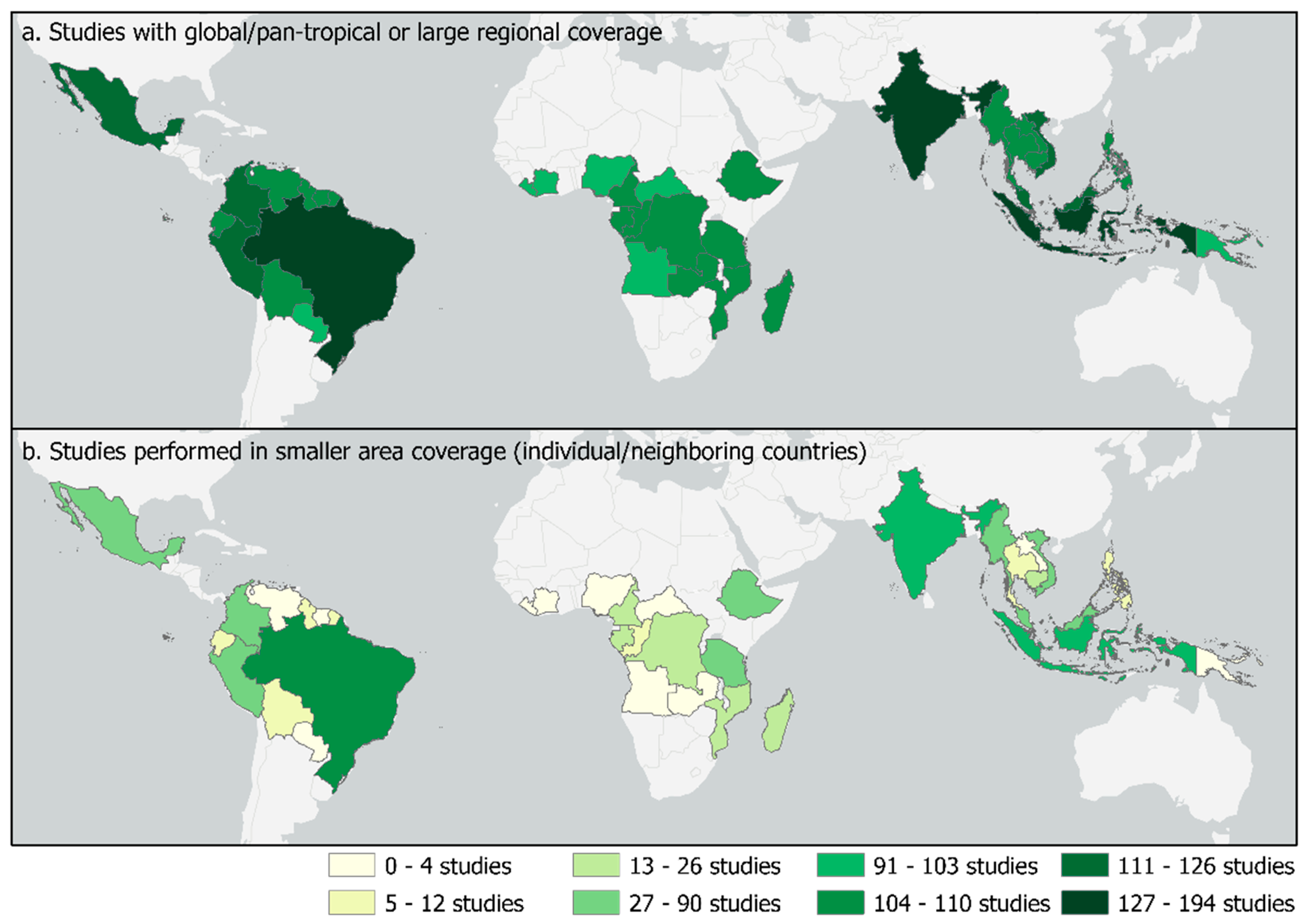
3.1. Systematic Literature Review

A total of 521 studies identified in the literature review were distributed throughout the area of interest, with more global/pan-tropical and large regional studies than studies that were performed in one or adjacent countries (419 studies performed in small area coverage) (Figure 2). More research was carried out in Asia and the Americas than in Africa, with concentrations in Brazil, India, and Indonesia.
The key focus of the selected studies was the use of remote sensing for forest monitoring. The satellite data most frequently being used was multi-resolution studies (26%) which combined satellites with different spatial resolutions, followed by the medium resolution studies, which had a spatial resolution between 10 and 50 meters/pixel (25%). When considering only the research carried out in a country or in adjacent countries, most studies used medium resolution (32%), and multi-resolution data (23%). This reflects the massive use of Landsat alone or in combination with other satellites. Only 12% of the studies were performed using methodologies unrelated to remote sensing (such as surveys, interviews, and inventories), showing the significance of the remote sensing techniques to forest monitoring (and criteria used in the Scopus search).
The two satellites that were used the most in the observed studies were Landsat followed by Sentinel, and for both, the distribution of their use was not equally spread across the study area (Figure 3). Although the pattern is largely driven by the frequency of studies in each country (Figure 2), there are some differences, and also variations in the general pattern of more Landsat studies. One example is Peru, which has more Sentinel studies than Landsat.
In the literature review, several categories of studies related to forest monitoring were identified (Figure 4). Most of the studies covered more than one theme. The category with the most studies was activity data (252 studies), which included research about deforestation, degradation, and reforestation. The other two categories with the highest number of studies were land use and land management (194 studies), and biomass and carbon stocks (119 studies). Even though there were many studies related to activity data, they were mostly performed in “hot spot” countries, which largely reflected the overall number of studies performed in each country. The land use and land management studies, however, were performed more evenly throughout the area of interest.
Research associated with near-real time forest monitoring was less frequently performed (51 studies), and 15 out of the 35 countries did not have a single study in this category. The studies related to analysis-ready data were also performed less (11 studies). However, some of them had global/pan-tropical or large regional coverage, which allowed for better distribution throughout the area of interest. The same can be stated about the methods and platforms category (62 studies), these studies were evenly dispersed due to the number of global/pan-tropical studies testing tools and using platforms for forest monitoring.

3.2. First Author Affiliation

The country of the affiliation(s) of the first authors of each of the papers showed a higher presence of affiliations in the northern hemisphere (Figure 5). Of research carried out in the 35 selected countries, most had a first author that was affiliated in the country where the research was being carried out. However, 16 of the countries did not have any studies where the leading author was affiliated with them. The calculated ratio between the frequency of research and the frequency of affiliation in the same country shows that, except for India, all the countries had a ratio that did not even reach 0.5 (meaning that less than half the time, the first author had no affiliation in that country).

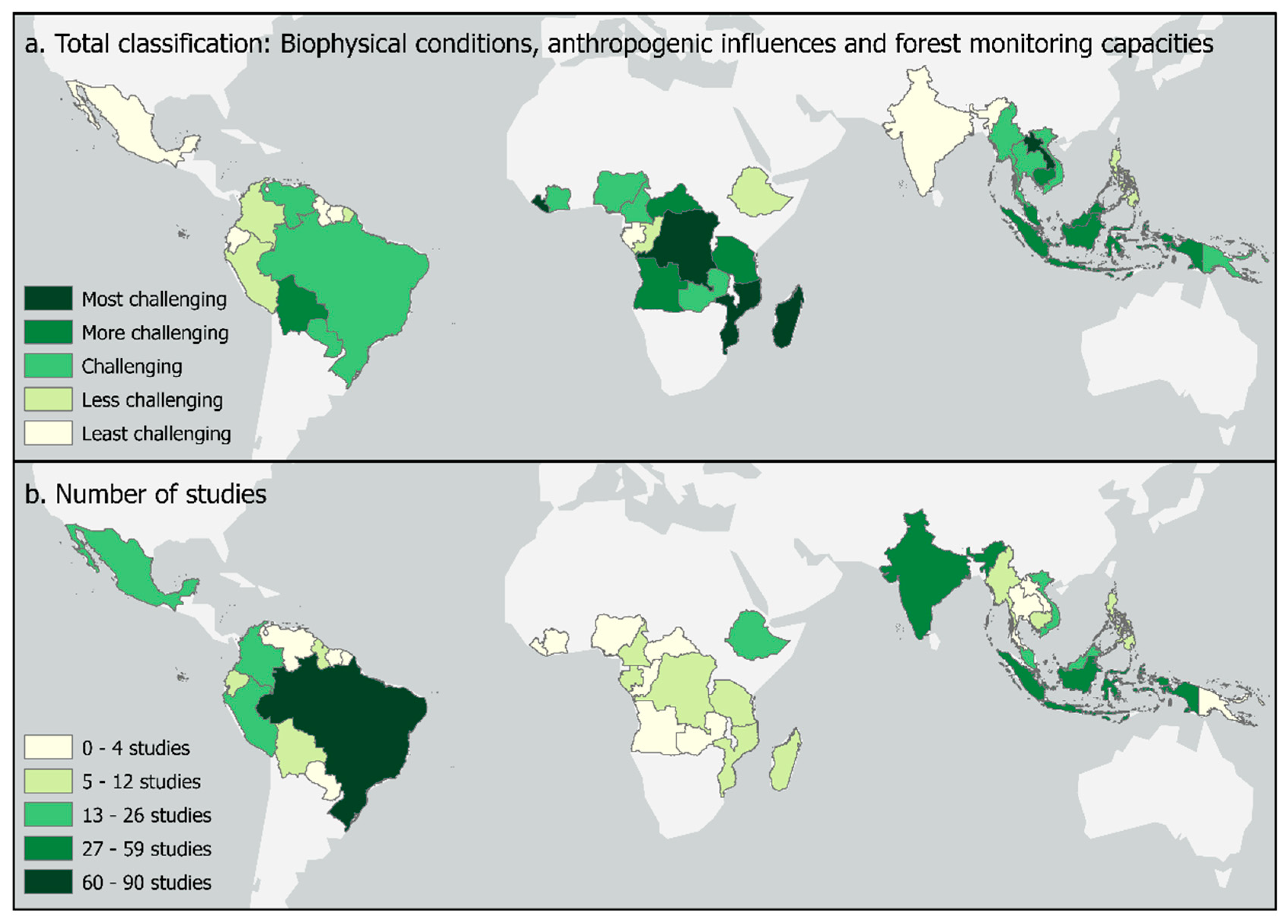
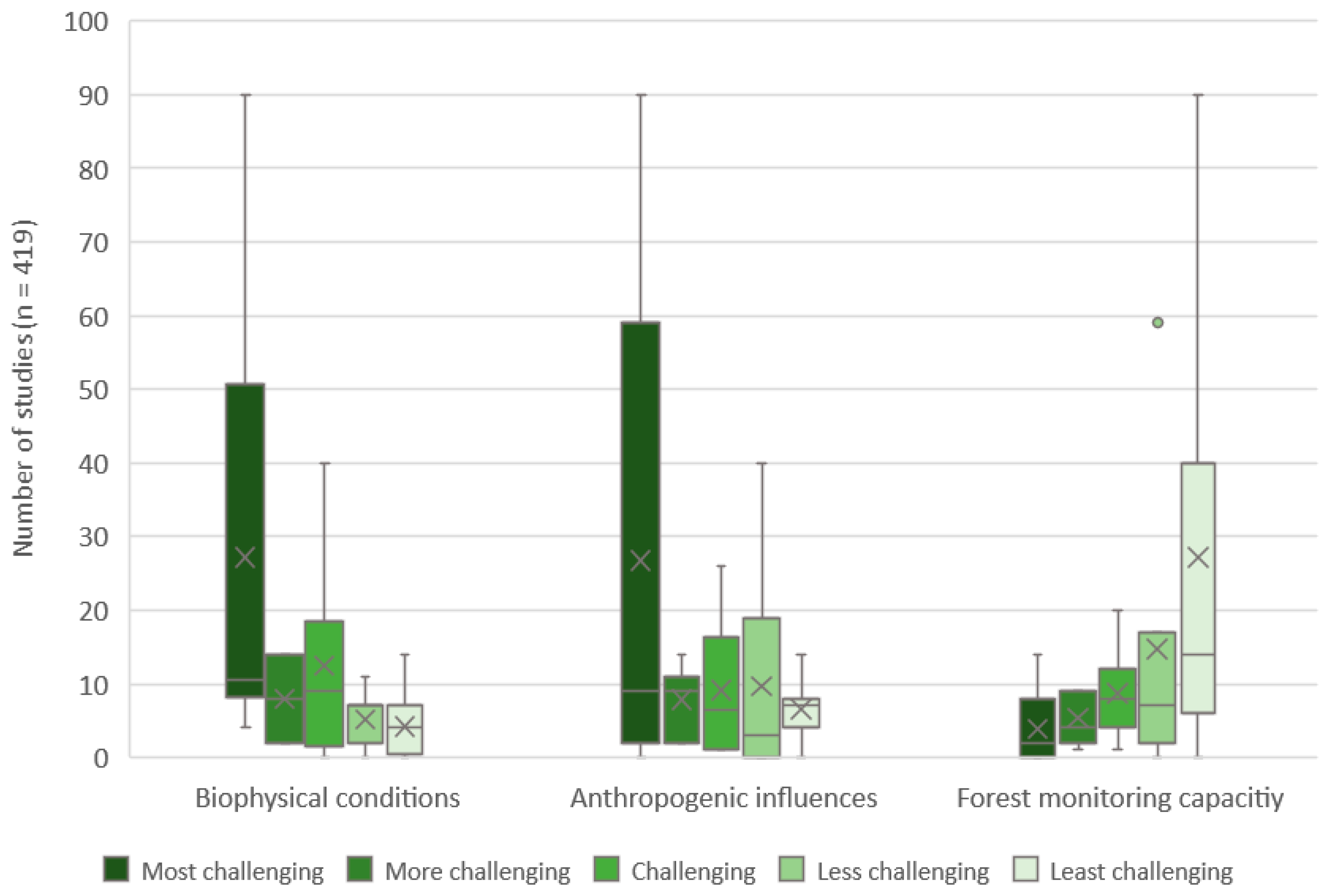
3.3. Correlation between the Studies Performed and the Countries Characteristics

The three variables used to identify the challenges, and need for forest monitoring (biophysical conditions, anthropogenic influences, and forest monitoring capacities) were combined to give an overall level of challenging characteristics related to forest monitoring research. This combination is represented in Figure 6, together with the number of studies performed in one or adjacent countries.
A correlation matrix was created using the Spearman rank-order correlation to explore the association between the number of research studies and the country characteristics related to the challenges and need for forest monitoring. Among the three categories, forest monitoring capacities is the only one with a moderately positive correlation to the number of studies (0.55 for both the global/pan-tropical and regional studies, as well as for the ones performed in a smaller area coverage). Both the biophysical conditions and the anthropogenic influences presented a negative correlation to the number of studies. However, the correlation for the biophysical conditions can be considered moderately negative (−0.43 for global/pan-tropical and regional studies, and −0.45 for studies performed in smaller area coverage), while the anthropogenic influences presented a weak negative correlation (−0.29 for both the global/pan-tropical and regional studies, as well as for the ones performed in a smaller area coverage). Overall, there is an indication that studies are likely to be performed in countries with good capacities for forest monitoring, where the biophysical conditions tend to be more challenging and where there are higher anthropogenic influences.
Box and whisker plots (Figure 7) show the distribution of the studies according to the level of challenges for forest monitoring-related research. There is a tendency for research to be performed in countries with better forest monitoring capacities (fewer challenging conditions). The opposite trend can be seen for the biophysical conditions, with more studies being carried out in areas with more challenging conditions. In contrast, the anthropogenic influences do not present any clear trends on how the studies are distributed regarding the level of challenge faced by the countries.
The number of studies could be driven by the size of the country, as much as by their characteristics, with a large country that carries out a lot of research skewing the results. Therefore, the same analysis was performed without the studies in Brazil which was the major “hot spot” for research between 2018 and 2020, representing 21% of the number of studies performed in a country or in that country and adjacent countries. Small differences could be seen, however, the trends observed remained.

4. Discussion

4.1. Distribution, Categories, and the Country of the Affiliation of the First Authors of Recent Research

Between 2018 and 2020, Brazil, India, Indonesia, and Mexico were found to be “hot spots” for tropical forest research, with the African countries being the least studied. The amount of research seems better distributed between the countries once the studies developed on a global/pan-tropical or large regional scale were considered in the assessment. However, in both considerations, the same countries are highlighted as “hot spots” for research studies. Global studies, on the one hand, are relevant to understand better global patterns of forest changes and dynamics. Local studies, on the other hand, provide insight into the questions that are most important to each region, focusing on their circumstances and how to address their specific challenges. In addition, local (country level) studies can be tuned to the local conditions so they are likely to provide more accurate results than a global study would provide for the same country. Given that the majority of African countries were found to have the most challenging conditions, and the greatest need for forest monitoring, an increase in the number of local studies in Africa would be beneficial.
As stated by [10], monitoring can have several aims and can focus on a number of different parameters and themes. In this research, there was a predominance of studies related to activity data. This seems logical when considering that those studies are related to deforestation and degradation, which, according to the International Union for Conservation of Nature, are the biggest threats to tropical forests. In addition, this is one of the key data needs when reporting to international policies related to climate change, and one for which EO data can be especially useful. The next most common categories were land use and land management, and biomass and carbon stocks. Biomass and carbon stocks as potential inputs to emissions factor estimates, in combination with activity data, to estimate emissions, or as direct estimates of emissions, are understandably prominent in the literature review.
Although the number of studies was limited, there were studies identified which were focused on method development such as uncertainty analysis. These studies can be potentially crucial for improvements of emissions estimates — such as [37]. A number of studies were identified which present platforms that can promote and improve public access to information, and these platforms have also proved to be crucial for forest monitoring efforts [38,39]. Near-real-time (NRT) forest monitoring studies were less represented in the results of the literature search, and some countries did not have a single study in this category. NRT has some limitations, such as spatial accuracy [26], and due to their poor spatial coverage according to this research, more studies are needed. The recent availability of data suitable for NRT analyses could be the reason for the lack of NRT monitoring studies in recent years.
Most of the studies are led by researchers affiliated with institutions from non-tropical countries. The United States was the country with the highest number of first authors, followed by Brazil and the United Kingdom. Brazil was the exception among the countries in the tropical countries, but this is mainly a reflection of the fact that it was the country with the highest number of studies overall, although the ratio of studies to affiliated authors was also relatively high (0.77).

4.2. Needs and Challenges for Forest Monitoring

Overall, there was no relationship found between all the three criteria used to identify the need for forest monitoring (biophysical conditions, anthropogenic influences, and forest monitoring capacities). The comparison of the studies developed exclusively in each country with the total classification of how the countries perform revealed that most of the studies are not being done in the countries with the higher needs for them. The absence of a pattern of where research is being done indicates that study areas have been possibly chosen using drivers like funding and investments, other than by considering the needs of each country (although funding and investments might be assumed to be somewhat driven by country needs). When comparing the location of the studies with the characteristics observed in each country, there is an indication that research tends to be performed in countries with good forest monitoring capacity, which are generally affected by challenging biophysical conditions. The intensity of anthropogenic influences did not seem to influence the number of studies. In general, countries with good monitoring capacities are also capable of establishing their own research through field support, ground data provision, and even authoring their own research, which could be a reason for the more prominent number of studies. Furthermore, more support should be provided to countries with lower capacities for forest monitoring. In addition to research on the monitoring themes addressed in this study, more awareness is needed over technical training, system maintenance, and enhancing data gathering and approaches [27].

4.3. Implications for Future Research Efforts

There are cases in which countries with limited or intermediate capacities for forest monitoring are the target of research, which will eventually translate into higher capacity developments [40]. In the main, it was found that research is still concentrating on countries with better monitoring capacities. One possibility for the greater number of studies in countries with higher capacity for forest monitoring could be the fact that past research led to an increase in capacity, and, consequently, the number of studies being performed continued to increase. However, many research studies still focus on the countries with better capacities, causing a lack of quality information required for climate related reporting in some countries. Although capacities have been increasing recently, a number of countries still have a limited capacity for forest monitoring related reporting [21]. This study also evaluated the FRA reports and found that almost 50% of the countries in this study report on less than 23 out of the 36 variables selected. Based on the results of this research, future research should be targeted to countries with lower capacities and higher needs—such as Madagascar and Angola. In order to increase research, in-country capacities for leading research (based on the first author affiliation of studies explored) should be increased. There are several ways in which this can be done. Increased training and capacity-building from donors and other initiatives, such as bi-lateral efforts, which are typically driven by developed countries. In addition, South-South capacity building should be promoted, which can take advantage of the counties in the Global South which already have high capacities (for example India and Brazil). At the same time, global/pan-tropical and large regional studies also have value in that they provide information that is comparable across countries and can be useful for global reporting. Ultimately, better monitoring and conservation of forest areas can be achieved, and stronger management decisions and restoration endeavors can be employed in the whole tropical zone. Nationally driven studies are also important, and there is a need for national ownership of research, which can also lead to better acceptance of results and data at the national level.
In light of the urgent need to protect forests—as seen by the anthropogenic influences explored in this study, there is a need for financial support, investments in training and capacity growth, and inter-disciplinary collaboration in future research in order to protect forests better. Research should target themes that are currently understudied, for instance, the use of near-real time forest monitoring approaches, and monitoring forest types that are particularly challenging, such as dry forests and mangroves. In the case of mangroves, opportunities for combining data (i.e., optical and different radar bands) might provide solutions for challenges related to inundation and wet soils. Even though it might be assumed that researchers prefer to select case studies with more straightforward conditions to demonstrate new concepts more clearly, this study did not find that research was concentrated in countries with less challenging conditions, although other conditions, such as cloud cover and hilly terrain, might also influence the choice of location and these and other challenges were not considered. Ground data collection could also be a focus of future research, particularly in areas which display these challenges (cloud cover, which inhibits the use of high-resolution optical data, and hilly terrain for example) and is something which would benefit from a study of its own to identify specific research challenges. Since this study only looked at the national level, it could be that more difficult forest types and research areas were avoided, and this could be explored by assessing the exact location of the studies identified by the literature review. There was a lack of previous studies similar to this, which meant methods for this research had to be tested and could be further refined, but this also provides a unique and novel perspective on forest monitoring research needs. The short duration of the search (2018–2020) means that longer-term monitoring progress and advances are not well captured, and a study of older and more recent literature would provide a better picture of the progress to date. On the author affiliation, this study only looked at first author affiliations since the interest was in research led by a specific country organization, however it could be that the other authors in the paper had the country affiliation and also had a significant role in the development and implementation of the study, and this is not captured by the results. Finally, the choice of the 35 selected countries, instead of the use of the whole tropical zone, might provide different findings than if the whole of the tropical zone was included. The findings of this study can be seen in light of these and other limitations.

5. Conclusions

The research provided an overview of the type of studies being performed in the 35 countries in the tropical region in relation to challenges of implementing forest monitoring research at the national level: their biophysical conditions, the anthropogenic influences acting on their forests, and their capacities for monitoring it. Relevant studies published between 2018 and 2020 highlighted the dominance of northern countries leading research developments in tropical countries.
There was no apparent relationship between the need for research (as determined by higher human impacts or having biophysical conditions that are harder to monitor and having more limited capacities for monitoring the forests) and the number of studies in a country. There is, however, an indication that research tends to be performed in countries with good capacities for forest monitoring that face biophysical and anthropogenic challenges. Quality information about the forests and their conditions is essential and research can be a way to support this need. Currently, some countries in the tropical zone have lower capacities for monitoring and do not have a representative number of studies performed in their territories. Therefore, capacity development is needed to lead those countries towards better forest monitoring.

Author Contributions

Conceptualization, J.M.M., S.C. and M.H.; Investigation, J.M.M.; Methodology, J.M.M.; Supervision, S.C. and M.H.; Visualization, J.M.M.; Writing—original draft, J.M.M.; Writing—review & editing, S.C. All authors have read and agreed to the published version of the manuscript.

Funding

This study was supported by the REDD Copernicus (https://www.reddcopernicus.info/) project and received funding from the European Union’s Horizon 2020 Work Programme 2018–2020 Leadership in Enabling and Industrial Technologies—Space, Coordinated Support Action under Grant Agreement No 821880.

Informed Consent Statement

Not applicable.

Data Availability Statement

Publicly available datasets were analysed in this study. This data can be found here: http://lucid.wur.nl/datasets/forest-monitoring-research-challenges.

Conflicts of Interest

The authors declare no conflict of interest.

References

  1. FAO; UNEP. The State of the World’s Forests: Forests, Biodiversity and People; FAO: Rome, Italy, 2020; ISBN 9789251324196. [Google Scholar]
  2. Pan, Y.; Birdsey, R.A.; Fang, J.; Houghton, R.; Kauppi, P.E.; Kurz, W.A.; Phillips, O.L.; Shvidenko, A.; Lewis, S.L.; Canadell, J.G.; et al. A Large and Persistent Carbon Sink in the World’s Forests. Science 2011, 333, 988–993. [Google Scholar] [CrossRef] [Green Version]
  3. Miura, S.; Amacher, M.; Hofer, T.; San-Miguel-Ayanz, J.; Thackway, R. Protective Functions and Ecosystem Services of Global Forests in the Past Quarter-Century. For. Ecol. Manag. 2015, 352, 35–46. [Google Scholar] [CrossRef] [Green Version]
  4. Hosonuma, N.; Herold, M.; de Sy, V.; de Fries, R.S.; Brockhaus, M.; Verchot, L.; Angelsen, A.; Romijn, E. An Assessment of Deforestation and Forest Degradation Drivers in Developing Countries. Environ. Res. Lett. 2012, 7. [Google Scholar] [CrossRef]
  5. Carter, S.; Herold, M.; Avitabile, V.; de Bruin, S.; de Sy, V.; Kooistra, L.; Rufino, M.C. Agriculture-Driven Deforestation in the Tropics from 1990–2015: Emissions, Trends and Uncertainties. Environ. Res. Lett. 2018, 13, 014002. [Google Scholar] [CrossRef] [Green Version]
  6. IUCN Deforestation and Forest Degradation. Available online: https://www.iucn.org/resources/issues-briefs/deforestation-and-forest-degradation (accessed on 1 May 2021).
  7. Foley, J.A.; DeFries, R.; Asner, G.P.; Barford, C.; Bonan, G.; Carpenter, S.R.; Chapin, F.S.; Coe, M.T.; Daily, G.C.; Gibbs, H.K.; et al. Global Consequences of Land Use. Science 2005, 309, 570–574. [Google Scholar] [CrossRef] [Green Version]
  8. Morris, R.J. Anthropogenic Impacts on Tropical Forest Biodiversity: A Network Structure and Ecosystem Functioning Perspective. Philos. Trans. R. Soc. B Biol. Sci. 2010, 365, 3709–3718. [Google Scholar] [CrossRef] [PubMed] [Green Version]
  9. Salvini, G.; Herold, M.; de Sy, V.; Kissinger, G.; Brockhaus, M.; Skutsch, M. How Countries Link REDD+ Interventions to Drivers in Their Readiness Plans: Implications for Monitoring Systems. Environ. Res. Lett. 2014, 9, 074004. [Google Scholar] [CrossRef] [Green Version]
  10. Ferretti, M. Forest monitoring. An introduction. In Developments in Environmental Science; Elsevier Ltd.: Amsterdam, The Netherlands, 2013; Volume 12, pp. 3–18. [Google Scholar]
  11. Romijn, E.; Lantican, C.B.; Herold, M.; Lindquist, E.; Ochieng, R.; Wijaya, A.; Murdiyarso, D.; Verchot, L. Assessing Change in National Forest Monitoring Capacities of 99 Tropical Countries. For. Ecol. Manag. J. 2015. [Google Scholar] [CrossRef] [Green Version]
  12. Achard, F.; DeFries, R.; Eva, H.; Hansen, M.; Mayaux, P.; Stibig, H. Pan-Trop Monit Deforestation. Res. Lett. 2007, 2, 45022–45033. [Google Scholar] [CrossRef] [Green Version]
  13. Federici, S.; Lee, D.; Herold, M. Forest Mitigation: A Permanent Contribution to the Paris Agreement? WorNing Pap 2017. [Google Scholar] [CrossRef]
  14. Keenan, R.J.; Reams, G.A.; Achard, F.; de Freitas, J.V.; Grainger, A.; Lindquist, E. Dynamics of Global Forest Area: Results from the FAO Global Forest Resources Assessment 2015. For. Ecol. Manag. 2015, 352, 9–20. [Google Scholar] [CrossRef]
  15. Petersen, R.; Davis, C.; Herold, M.; de Sy, V. Tropical Forest Monitoring: Exploring the Gaps between What Is Required and What Is Possible for REDD+ and Other Initiatives; World Resources Institute: Washington, DC, USA, 2018; pp. 1–5. [Google Scholar]
  16. Davies, S.J.; Abiem, I.; Abu Salim, K.; Aguilar, S.; Allen, D.; Alonso, A.; Anderson-Teixeira, K.; Andrade, A.; Arellano, G.; Ashton, P.S.; et al. ForestGEO: Understanding Forest Diversity and Dynamics through a Global Observatory Network. Biol. Conserv. 2021, 253, 108907. [Google Scholar] [CrossRef]
  17. Randin, C.F.; Ashcroft, M.B.; Bolliger, J.; Cavender-Bares, J.; Coops, N.C.; Dullinger, S.; Dirnböck, T.; Eckert, S.; Ellis, E.; Fernández, N.; et al. Monitoring Biodiversity in the Anthropocene Using Remote Sensing in Species Distribution Models. Remote. Sens. Environ. 2020, 239, 111626. [Google Scholar] [CrossRef]
  18. Powell, T.L.; Galbraith, D.R.; Christoffersen, B.O.; Harper, A.; Imbuzeiro, H.M.A.; Rowland, L.; Almeida, S.; Brando, P.M.; da Costa, A.C.L.; Costa, M.H.; et al. Confronting Model Predictions of Carbon Fluxes with Measurements of Amazon Forests Subjected to Experimental Drought. New Phytol. 2013, 200, 350–365. [Google Scholar] [CrossRef] [PubMed] [Green Version]
  19. Mcroberts, R.E.; Cohen, W.B.; Erik, N.; Stehman, S.V.; Tomppo, E.O. Using Remotely Sensed Data to Construct and Assess Forest Attribute Maps and Related Spatial Products. Scand. J. For. Res. 2010, 25, 340–367. [Google Scholar] [CrossRef]
  20. Carter, S.; Herold, M.; Misiukas, J.M. Research And Development Needs For REDD+ And Forest Monitoring. In Proceedings of the IEEE IGARSS 2021, Brussels, Belgium, 12–14 July 2021. [Google Scholar]
  21. Nesha, M.K.; Herold, M.; De Sy, V.; Duchelle, A.E.; Martius, C.; Branthomme, A.; Garzuglia, M.; Jonsson, O.; Pekkarinen, A. An assessment of data sources, data quality and changes in national forest monitoring capacities in the Global Forest Resources Assessment 2005–2020. Environ. Res. Lett. 2021, 16, 054029. [Google Scholar] [CrossRef]
  22. Thomson, A.J. Information management and data registration. In Knowledge Reference for National Forest Assessments; Food and Agriculture Organization of the United Nations: Rome, Italy, 2015; pp. 93–110. ISBN 9789253088324. [Google Scholar]
  23. Tulyasuwan, N.; Henry, M.; Secrieru, M.; Jonckheere, I.; Federici, S. Issues and Challenges for the National System for Greenhouse Gas Inventory in the Context of REDD+. Greenh. Gas Meas. Manag. 2012, 2, 73–83. [Google Scholar] [CrossRef]
  24. Bucki, M.; Cuypers, D.; Mayaux, P.; Achard, F.; Estreguil, C.; Grassi, G. Assessing REDD+ performance of countries with low monitoring capacities: The matrix approach. Environ. Res. Lett. 2012, 7. [Google Scholar] [CrossRef]
  25. Herold, M.; Skutsch, M. Monitoring, reporting and verification for national REDD + programmes: Two proposals. Environ. Res. Lett. 2011, 6, 14002. [Google Scholar] [CrossRef]
  26. Giri, C.; Zhu, Z.; Tieszen, L.L.; Singh, A.; Gillette, S.; Kelmelis, J.A. Mangrove forest distributions and dynamics (1975–2005) of the tsunami-affected region of Asia. J. Biogeogr. 2007, 35, 519–528. [Google Scholar] [CrossRef]
  27. Olson, D.M.; Dinerstein, E. The Global 200: Priority Ecoregions for Global Conservation. Proc. Ann. Mo. Bot. Gard. 2002, 89, 199–224. [Google Scholar] [CrossRef]
  28. Kuenzer, C.; Bluemel, A.; Gebhardt, S.; Quoc, T.V.; Dech, S. Remote Sensing of Mangrove Ecosystems: A Review. Remote. Sens. 2011, 3, 878–928. [Google Scholar] [CrossRef] [Green Version]
  29. Hakimdavar, R.; Hubbard, A.; Policelli, F.; Pickens, A.; Hansen, M.; Fatoyinbo, T.; Lagomasino, D.; Pahlevan, N.; Unninayar, S.; Kavvada, A.; et al. Monitoring Water-Related Ecosystems with Earth Observation Data in Support of Sustainable Development Goal (SDG) 6 Reporting. Remote. Sens. 2020, 12, 1634. [Google Scholar] [CrossRef]
  30. Moonlight, P.W.; Banda-R, K.; Phillips, O.L.; Dexter, K.G.; Pennington, R.T.; Baker, T.R.; de Lima, H.C.; Fajardo, L.; González-M, R.; Linares-Palomino, R.; et al. Expanding tropical forest monitoring into Dry Forests: The DRYFLOR protocol for permanent plots. Plants People Planet 2021, 3, 295–300. [Google Scholar] [CrossRef]
  31. Global Forest Watch Forest Monitoring, Land Use & Deforestation Trends. Available online: https://www.globalforestwatch.org/ (accessed on 11 August 2020).
  32. Andela, N.; Morton, D.C.; Giglio, L.; Paugam, R.; Chen, Y.; Hantson, S.; Van Der Werf, G.R.; Randerson, J.T. The Global Fire Atlas of individual fire size, duration, speed and direction. Earth Syst. Sci. Data 2019, 11, 529–552. [Google Scholar] [CrossRef] [Green Version]
  33. Mackey, B.; Kormos, C.F.; Keith, H.; Moomaw, W.R.; Houghton, R.A.; Mittermeier, R.A.; Hole, D.; Hugh, S. Understanding the importance of primary tropical forest protection as a mitigation strategy. Mitig. Adapt. Strat. Glob. Chang. 2020, 25, 763–787. [Google Scholar] [CrossRef] [Green Version]
  34. Pessôa, A.; Anderson, L.; Carvalho, N.; Campanharo, W.; Junior, C.; Rosan, T.; Reis, J.; Pereira, F.; Assis, M.; Jacon, A.; et al. Intercomparison of Burned Area Products and Its Implication for Carbon Emission Estimations in the Amazon. Remote. Sens. 2020, 12, 3864. [Google Scholar] [CrossRef]
  35. SDG Internet Users Per 100 Inhabitants. Available online: http://www.sdg.org/datasets/indicator-17-8-1-internet-users-per-100-inhabitants-3?selectedAttribute=value_latest_year (accessed on 11 August 2020).
  36. FAO Global Forest Resources Assessment. Available online: https://fra-data.fao.org/WO/assessment/fra2020/forestCharacteristics/ (accessed on 12 August 2020).
  37. Olofsson, P.; Foody, G.; Herold, M.; Stehman, S.V.; Woodcock, C.E.; Wulder, M.A. Good practices for estimating area and assessing accuracy of land change. Remote. Sens. Environ. 2014, 148, 42–57. [Google Scholar] [CrossRef]
  38. Brovelli, M.A.; Sun, Y.; Yordanov, V. Monitoring Forest Change in the Amazon Using Multi-Temporal Remote Sensing Data and Machine Learning Classification on Google Earth Engine. ISPRS Int. J. Geo-Inf. 2020, 9, 580. [Google Scholar] [CrossRef]
  39. Kumar, L.; Mutanga, O. Google Earth Engine Applications Since Inception: Usage, Trends, and Potential. Remote Sens. 2018, 10, 1509. [Google Scholar] [CrossRef] [Green Version]
  40. Herold, M.; GOFC-GOLD Land Cover Project Office; Friedrich Schiller. An Assessment of National Forest Monitoring Capabilities in Tropical Non-Annex I Countries; Friedrich-Schiller-Universität Jena: Jena, Germany, 2009. [Google Scholar]
Figure 1. Classification of the countries regarding their biophysical conditions, anthropogenic influences, and forest monitoring capacities.
Remotesensing 13 02252 g001
Figure 2. Number of studies performed in each of the selected countries considering (a) global/pan-tropical and large regional studies, and (b) studies performed in small areas (individual /neighboring countries).
Remotesensing 13 02252 g002
Figure 3. Classification of the countries regarding the usage level of Landsat imagery, Sentinel imagery, other satellites, and use of a multi-resolution approach.
Remotesensing 13 02252 g003
Figure 4. Classification of the countries regarding the percentage of every category of study performed in each country between 2018 and 2020, where n represents the number of studies in each category. The percentages for each country across all panels total 100% (e.g., Brazil: 32.5% of studies related to activity data, 31.4% to land use and land management, 18.1% to biomass and carbon stocks, 13.4% to methods and platforms, 3.1% to near-real time alerting, and 1.5% to analysis ready).
Remotesensing 13 02252 g004
Figure 5. Classification of the studies regarding the country of affiliation of the first author, the frequency of research in the 35 selected countries, the frequency of research in the country where the first author was also affiliated and the ratio between the frequency of research and frequency of affiliation.
Remotesensing 13 02252 g005
Figure 6. Comparison of the final classification of the countries (biophysical conditions, anthropogenic influences, and forest monitoring capacities) and the location of the studies performed in small area coverage.
Remotesensing 13 02252 g006
Figure 7. Box and whiskers plot representing the proportion of studies per country in relation to their level of challenge for forest monitoring research. The “X” in each box represents the mean number of studies per countries classified in the categories of challenge.
Remotesensing 13 02252 g007
Table 1. Classification of the study categories observed with the literature review.
CategoryStudy Types Included in the Category
Analysis-ready dataStudies related to analysis ready wall-to-wall satellite data and analysis ready high-resolution imagery.
Activity dataStudies related to the forest area and land use/cover change (deforestation), forest degradation, afforestation, and forest regrowth.
Land use and land managementStudies related to forest dynamics data, forest types, land use, management characteristics, and other sustainability-related forest parameters.
Biomass stocks and carbon emissionStudies related to forest biomass stocks and change and forest related GHG emissions and removals.
Near-real time alertingStudies related to the use of near-real time imagery.
Methods and platformsStudies developing for example methodologies related to uncertainty/accuracy assessment methods, and extraction of map statistics, and studies related to the exploration/development of platforms.
Table 2. Search expression used in the Scopus database.
CriteriaKeywords and Search Expression
What?“deforestation” OR “forest degradation” OR “forest disturbance” OR “forest monitoring”
How?“remote sensing” OR “satellite imagery” OR “satellite data”
Where?“forests” OR “tropical forests” OR “rain forest” OR “Angola” OR “Brazil” OR “Bolivia” OR “Cambodia” OR “Cameroon” OR “Central African Republic” OR “Colombia” OR “Cote d’Ivoire” OR “Democratic Republic of Congo” OR “Ecuador” OR “Ethiopia” OR “French Guiana” OR “Gabon” OR “Guyana” OR “India” OR “Indonesia” OR “Laos” OR “Liberia” OR “Madagascar” OR “Malaysia” OR “Mexico” OR “Mozambique” OR “Myanmar” OR “Nigeria” OR “Papua New Guinea” OR “Paraguay” OR “Peru” OR “Philippines” OR “Republic of Congo” OR “Suriname” OR “Tanzania” OR “Thailand” OR “Venezuela” OR “Vietnam” OR “Zambia”
When?“2018” OR “2019” OR “2020”
Publisher’s Note: MDPI stays neutral with regard to jurisdictional claims in published maps and institutional affiliations.

