A Comparison of Two Machine Learning Classification Methods for Remote Sensing Predictive Modeling of the Forest Fire in the North-Eastern Siberia
Abstract
1. Introduction
2. Material and Methods
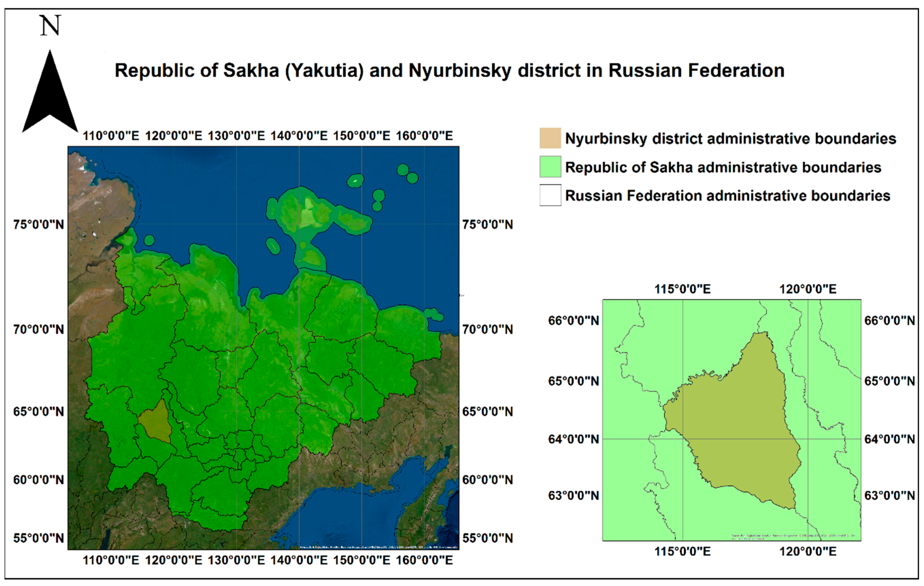
2.1. Yakutia
2.2. Spatial Monitoring Factors for Fire Forest Monitoring in Yakutia
2.2.1. Fires Data
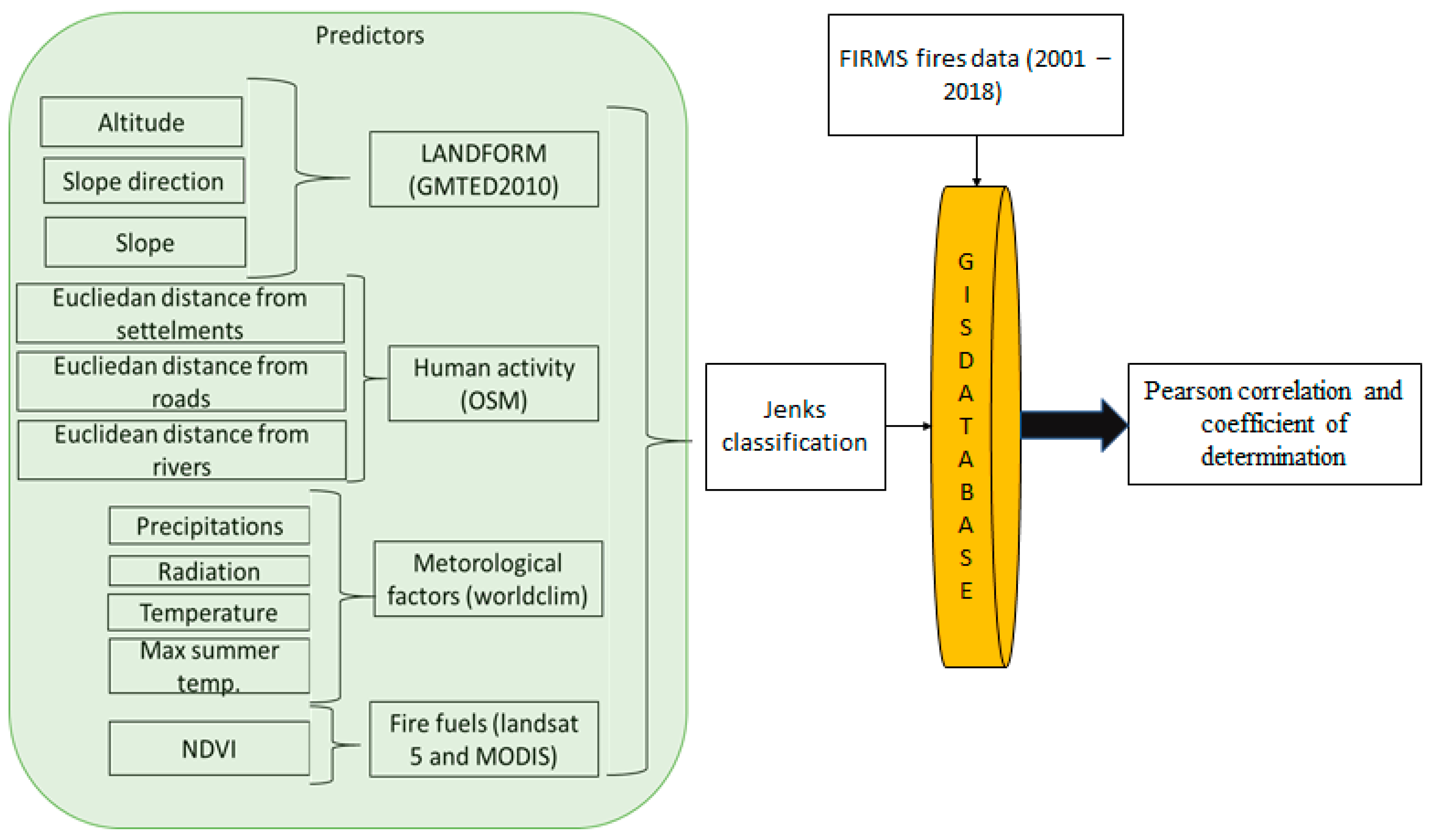
2.2.2. Factors Data
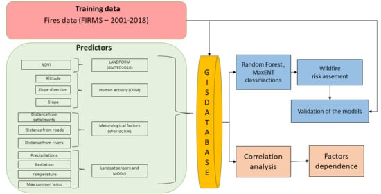
2.3. Modeling the Risk Assessment of Forest Fires
2.3.1. Fire Factors Analysis
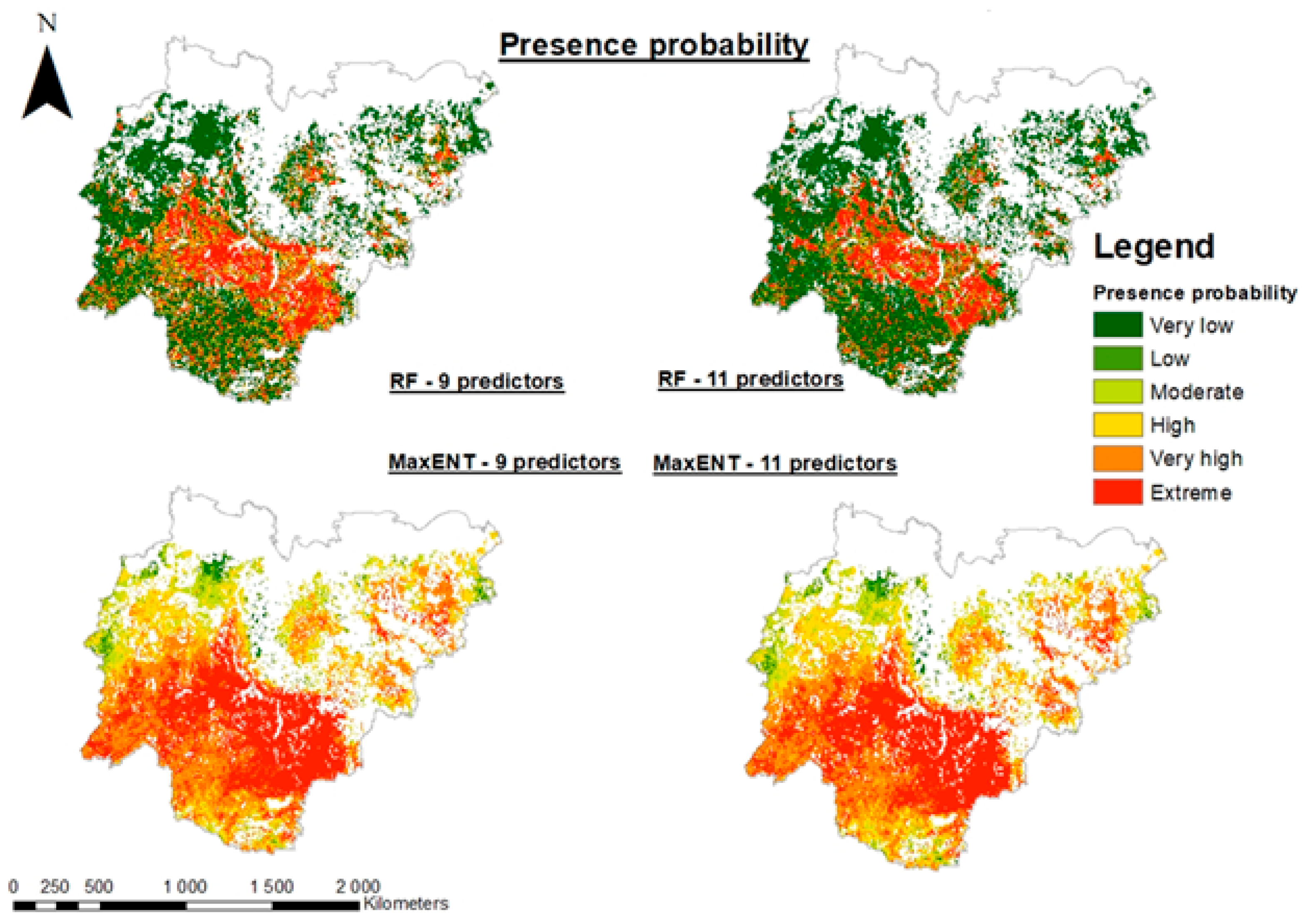
2.3.2. Long-Term Fire Risk Modeling
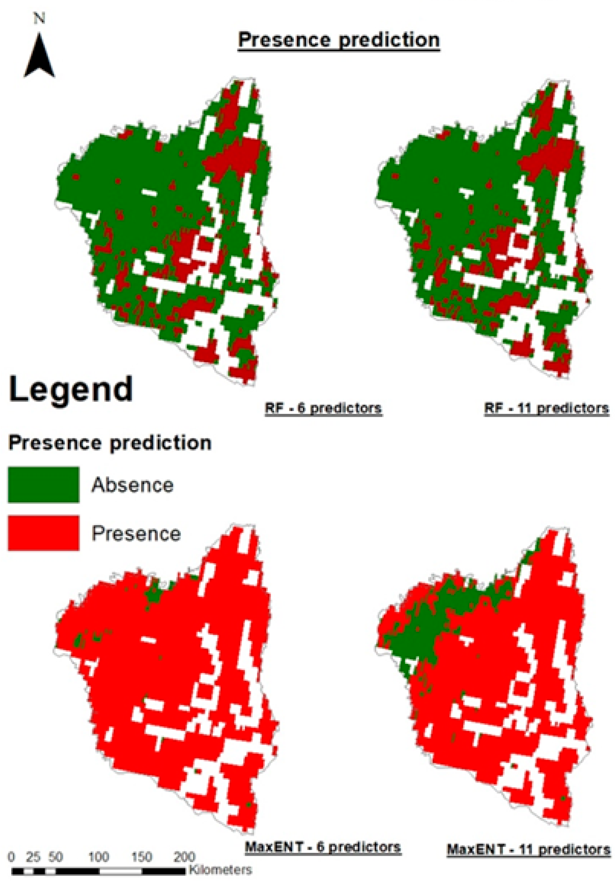
- Absence—there is the possibility of a forest fire.
- Presence—there is no possibility of the forest fire.
- Very low—very low possibility of the fire.
- Low—low possibility of fire.
- Moderate—moderate possibility of fire.
- High—high possibility of fire.
- Very high—very high possibility of fire.
- Extreme—extreme possibility of fire.
3. Results
3.1. Fire Factors
3.2. Fire Risk
4. Discussion
5. Conclusions
Author Contributions
Funding
Conflicts of Interest
References
- Kasischke, E.S.; Stocks, B.J. Fire, Climate Change, and Carbon Cycling in the Boreal Forest; Springer Science & Business Media: Berlin/Heidelberg, Germany, 2012; pp. 203–204. ISBN 978-0-387-21629-4. [Google Scholar]
- Troeva, E.I.; Isaev, A.P.; Cherosov, M.M.; Karpov, N.S. The Far North: Plant Biodiversity and Ecology of Yakutia; Springer Science & Business Media: Berlin/Heidelberg, Germany, 2010; pp. 203–204. ISBN 978-90-481-3774-9. [Google Scholar]
- San-Miguel-Ayanz, J.; Carlson, J.D.; Alexander, M.; Tolhurst, K.; Morgan, G.; Sneeuwjagt, R.; Dudley, M. Current Methods to Assess Fire Danger Potential. In Wildland Fire Danger Estimation and Mapping; Series in Remote Sensing; World Scientific: Singapore, 2003; Volume 4, pp. 21–61. ISBN 978-981-238-569-7. [Google Scholar]
- Ждaнко, B.A.; Гриценко, M.B. Mетод aнaлизa лесопожaрных сезонов: Прaктические рекомендaции. Л. ЛНИИЛХ 1980. (In Russian) [Google Scholar]
- Tedim, F.; Leone, V.; Amraoui, M.; Bouillon, C.; Coughlan, M.R.; Delogu, G.M.; Fernandes, P.M.; Ferreira, C.; McCaffrey, S.; McGee, T.K.; et al. Defining Extreme Wildfire Events: Difficulties, Challenges, and Impacts. Fire 2018, 1, 9. [Google Scholar] [CrossRef]
- Oliveira, S.; Oehler, F.; San-Miguel-Ayanz, J.; Camia, A.; Pereira, J.M.C. Modeling spatial patterns of fire occurrence in Mediterranean Europe using Multiple Regression and Random Forest. For. Ecol. Manag. 2012, 275, 117–129. [Google Scholar] [CrossRef]
- Cardille, J.A.; Ventura, S.J.; Monica, G.T. Environmental and social factors influencing wildfires in the Upper Midwest, United States. Ecol. Appl. 2001, 11, 111–127. [Google Scholar] [CrossRef]
- González-Cabán, A. Proceedings of the Second International Symposium on Fire Economics, Planning, and Policy: A Global View; U.S. Department of Agriculture, Forest Service, Pacific Southwest Research Station: Albany, CA, USA, 2008; 720p.
- Isaev, A.P.; Protopopov, A.V.; Protopopova, V.V.; Egorova, A.A.; Timofeyev, P.A.; Nikolaev, A.N.; Shurduk, I.F.; Lytkina, L.P.; Ermakov, N.B.; Nikitina, N.V.; et al. Vegetation of Yakutia: Elements of Ecology and Plant Sociology. In The Far North: Plant Biodiversity and Ecology of Yakutia; Troeva, E.I., Isaev, A.P., Cherosov, M.M., Karpov, N.S., Eds.; Plant and Vegetation; Springer: Dordrecht, The Netherlands, 2010; pp. 143–260. ISBN 978-90-481-3774-9. [Google Scholar]
- Cherosov, M.M.; Isaev, A.P.; Mironova, S.I.; Lytkina, L.P.; Gavrilyeva, L.D.; Sofronov, R.R.; Arzhakova, A.P.; Barashkova, N.V.; Ivanov, I.A.; Shurduk, I.F.; et al. Vegetation and Human Activity. In The Far North: Plant Biodiversity and Ecology of Yakutia; Troeva, E.I., Isaev, A.P., Cherosov, M.M., Karpov, N.S., Eds.; Plant and Vegetation; Springer: Dordrecht, The Netherlands, 2010; pp. 261–295. ISBN 978-90-481-3774-9. [Google Scholar]
- Peters, M.P.; Iverson, L.R.; Matthews, S.N.; Prasad, A.M. Wildfire hazard mapping: Exploring site conditions in eastern US wildland–urban interfaces. Int. J. Wildland Fire 2013, 22, 567–578. [Google Scholar] [CrossRef]
- Phillips, S.J.; Dudík, M. Modeling of species distributions with Maxent: New extensions and a comprehensive evaluation. Ecography 2008, 31, 161–175. [Google Scholar] [CrossRef]
- Gull, S.F.; Skilling, J. Maximum entropy method in image processing. In IEE Proceedings F (Communications, Radar and Signal Processing); IET Digital Library: London, UK, 1984; Volume 131, pp. 646–659. [Google Scholar]
- Aтлaс сельского хозяйствa ЯAССР, A. под редaкцией AГ Гущиной. M. Глaвное Упрaвление Геодезии и Кaртогрaфии при Совете Mинистров СССР 1989. (In Russian)
- Bоробьев, К.A.; Ким, A.Ю. Геогрaфический Aтлaс Республикa Сaхa (Якутия); Роскaртогрaфия: Якутск, Russia, 2000. (In Russian) [Google Scholar]
- Eловская, Л.Г. Клaссификaция и диaгностикa мерзлотных почв Якутии. Якутский филиaл СО AН СССР. 1987. Available online: https://search.rsl.ru/ru/record/01001419857 (accessed on 27 November 2020). (In Russian).
- Giglio, L. MODIS Collection 6 Active Fire Product User’s Guide Revision A. Available online: /paper/MODIS-Collection-6-Active-Fire-Product-User%27s-Guide-Giglio/4aacae34ad3bcd557591067399ebc38580eb8286 (accessed on 14 September 2020).
- Prichard, S.J.; Kennedy, M.C. Fuel treatments and landform modify landscape patterns of burn severity in an extreme fire event. Ecol. Appl. 2014, 24, 571–590. [Google Scholar] [CrossRef]
- Martínez, J.; Vega-Garcia, C.; Chuvieco, E. Human-caused wildfire risk rating for prevention planning in Spain. J. Environ. Manag. 2009, 90, 1241–1252. [Google Scholar] [CrossRef]
- Syphard, A.D.; Radeloff, V.C.; Keuler, N.S.; Taylor, R.S.; Hawbaker, T.J.; Stewart, S.I.; Clayton, M.K. Predicting spatial patterns of fire on a southern California landscape. Int. J. Wildland Fire 2008, 17, 602–613. [Google Scholar] [CrossRef]
- Kwak, H.; Lee, W.-K.; Saborowski, J.; Lee, S.-Y.; Won, M.-S.; Koo, K.-S.; Lee, M.-B.; Kim, S.-N. Estimating the spatial pattern of human-caused forest fires using a generalized linear mixed model with spatial autocorrelation in South Korea. Int. J. Geogr. Inf. Sci. 2012, 26, 1589–1602. [Google Scholar] [CrossRef]
- Fick, S.E.; Hijmans, R.J. WorldClim 2: New 1-km spatial resolution climate surfaces for global land areas. Int. J. Climatol. 2017, 37, 4302–4315. [Google Scholar] [CrossRef]
- Onigemo, A.E.; Santos, S.A.; Pellegrin, L.A.; Abreu, U.G.P.; Silva, E.T.J.; Soriano, B.M.A.; Crispim, S.M.A. Application of vegetation index to assess fire risk in open grasslands with predominance of cespitous grasses in the Nhecolândia sub-region of the Pantanal. Simpósio Bras. Sens. Remoto 2007, 13, 4493–4500. [Google Scholar]
- Illera, P.; Fernández, A.; Delgado, J.A. Temporal evolution of the NDVI as an indicator of forest fire danger. Int. J. Remote Sens. 1996, 17, 1093–1105. [Google Scholar] [CrossRef]
- Goward, C.R.; Murphy, J.P.; Atkinson, T.; Barstow, D.A. Expression and purification of a truncated recombinant streptococcal protein G. Biochem. J. 1990, 267, 171–177. [Google Scholar] [CrossRef]
- Danielson, J.J.; Gesch, D.B. Global Multi-Resolution Terrain Elevation Data 2010 (GMTED2010); US Department of the Interior, US Geological Survey: Newton, MA, USA, 2011.
- Pew, K.L.; Larsen, C.P.S. GIS analysis of spatial and temporal patterns of human-caused wildfires in the temperate rain forest of Vancouver Island, Canada. For. Ecol. Manag. 2001, 140, 1–18. [Google Scholar] [CrossRef]
- Zhang, Z.X.; Zhang, H.Y.; Zhou, D.W. Using GIS spatial analysis and logistic regression to predict the probabilities of human-caused grassland fires. J. Arid Environ. 2010, 74, 386–393. [Google Scholar]
- Jenks, G.F. The Data Model Concept in Statistical Mapping. Int. Yearb. Cartogr. 1967, 7, 186–190. [Google Scholar]
- Parisien, M.-A.; Snetsinger, S.; Greenberg, J.A.; Nelson, C.R.; Schoennagel, T.; Dobrowski, S.Z.; Moritz, M.A. Spatial variability in wildfire probability across the western United States. Int. J. Wildland Fire 2012, 21, 313–327. [Google Scholar] [CrossRef]
- Harte, J.; Newman, E.A. Maximum information entropy: A foundation for ecological theory. Trends Ecol. Evol. 2014, 29, 384–389. [Google Scholar] [CrossRef]
- Elith, J.; Graham, C.H.; Anderson, R.P.; Dudík, M.; Ferrier, S.; Guisan, A.; Hijmans, R.J.; Huettmann, F.; Leathwick, J.R.; Lehmann, A. Novel methods improve prediction of species’ distributions from occurrence data. Ecography 2006, 29, 129–151. [Google Scholar] [CrossRef]
- Franklin, J. Mapping Species Distributions: Spatial Inference and Prediction; Cambridge University Press: Cambridge, UK, 2010; ISBN 978-1-139-48529-6. [Google Scholar]
- Renard, Q.; Pélissier, R.; Ramesh, B.R.; Kodandapani, N. Environmental susceptibility model for predicting forest fire occurrence in the Western Ghats of India. Int. J. Wildland Fire 2012, 21, 368–379. [Google Scholar] [CrossRef]
- Cutler, D.R.; Edwards, T.C., Jr.; Beard, K.H.; Cutler, A.; Hess, K.T.; Gibson, J.; Lawler, J.J. Random forests for classification in ecology. Ecology 2007, 88, 2783–2792. [Google Scholar] [CrossRef]
- Blanchi, R.; Jappiot, M.; Alexandrian, D. Forest fire risk assessment and cartography. A methodological approach. In Proceedings of the IV International Conference on Forest Fire Research, Luso, Portugal, 18–23 November 2002. [Google Scholar]
- Tehrany, M.S.; Jones, S.; Shabani, F.; Martínez-Álvarez, F.; Bui, D.T. A novel ensemble modeling approach for the spatial prediction of tropical forest fire susceptibility using logitboost machine learning classifier and multi-source geospatial data. Theor. Appl. Climatol. 2019, 137, 637–653. [Google Scholar] [CrossRef]
- Koetz, B.; Morsdorf, F.; van der Linden, S.; Curt, T.; Allgöwer, B. Multi-Source land cover classification for forest fire management based on imaging spectrometry and LiDAR data. For. Ecol. Manag. 2008, 256, 263–327. [Google Scholar] [CrossRef]
- Gai, C.; Weng, W.; Yuan, H. GIS-Based forest fire risk assessment and mapping. In Proceedings of the 2011 Fourth International Joint Conference on Computational Sciences and Optimization, Kunming/Lijiang, China, 5–19 April 2011; pp. 1240–1244. [Google Scholar]
- You, W.; Lin, L.; Wu, L.; Ji, Z.; Yu, J.; Zhu, J.; Fan, Y.; He, D. Geographical information system-based forest fire risk assessment integrating national forest inventory data and analysis of its spatiotemporal variability. Ecol. Indic. 2017, 77, 176–184. [Google Scholar] [CrossRef]
- Goldarag, Y.J.; Mohammadzadeh, A.; Ardakani, A.S. Fire risk assessment using neural network and logistic regression. J. Indian Soc. Remote Sens. 2016, 44, 885–894. [Google Scholar] [CrossRef]
- Andreev, D.V.; Makarova, M.E. GIS technologies application in useful fossils search in the territory of the Republic of Sakha (Yakutia). In Proceedings of the IOP Conference Series: Earth and Environmental Science, Changsha, China, 18–20 September 2020; IOP Publishing: Bristol, UK, 2020; Volume 548, p. 032006. [Google Scholar]
- Boike, J.; Grau, T.; Heim, B.; Günther, F.; Langer, M.; Muster, S.; Gouttevin, I.; Lange, S. Satellite-derived changes in the permafrost landscape of central Yakutia, 2000–2011: Wetting, drying, and fires. Glob. Planet. Chang. 2016, 139, 116–127. [Google Scholar] [CrossRef]
- Lim, C.-H.; Kim, Y.S.; Won, M.; Kim, S.J.; Lee, W.-K. Can satellite-based data substitute for surveyed data to predict the spatial probability of forest fire? A geostatistical approach to forest fire in the Republic of Korea. Geomat. Nat. Hazards Risk 2019, 10, 719–739. [Google Scholar] [CrossRef]
- Pourghasemi, H.R.; Kariminejad, N.; Amiri, M.; Edalat, M.; Zarafshar, M.; Blaschke, T.; Cerda, A. Assessing and mapping multi-hazard risk susceptibility using a machine learning technique. Sci. Rep. 2020, 10, 1–11. [Google Scholar] [CrossRef]
- Курбaтский, Н.П. Техникa и тaктикa тушения лесных пожaров. M. Гослесбумиздaт 1962. (In Russian) [Google Scholar]
- Ghorbanzadeh, O.; Blaschke, T.; Gholamnia, K.; Aryal, J. Forest fire susceptibility and risk mapping using social/infrastructural vulnerability and environmental variables. Fire 2019, 2, 50. [Google Scholar] [CrossRef]
- Dennison, P.E.; Roberts, D.A.; Reggelbrugge, J.C. Characterizing chaparral fuels using combined hyperspectral and synthetic aperture radar data. In Proceedings of the 9th AVIRIS Earth Science Workshop, Pasadena, CA, USA, 23–25 February 2000; Jet Propulsion Lab: Pasadena, CA, USA, 2000; Volume 6, pp. 23–25. [Google Scholar]
- Ajin, R.S.; Loghin, A.-M.; Jacob, M.K.; Vinod, P.G.; Krishnamurthy, R.R. The risk assessment study of potential forest fire in Idukki Wildlife Sanctuary using RS and GIS techniques. Int. J. Adv. Earth Sci. Eng. 2016, 5, 308–318. [Google Scholar]
- Werf, G.R.; Randerson, J.T.; Giglio, L.; Collatz, G.J.; Mu, M.; Kasibhatla, P.S.; Morton, D.C.; DeFries, R.S.; Jin, Y.; van Leeuwen, T.T. Global fire emissions and the contribution of deforestation, savanna, forest, agricultural, and peat fires (1997–2009). Atmos. Chem. Phys. 2010, 10, 11707–11735. [Google Scholar] [CrossRef]
- Gigović, L.; Pourghasemi, H.R.; Drobnjak, S.; Bai, S. Testing a new ensemble model based on SVM and random forest in forest fire susceptibility assessment and its mapping in Serbia’s Tara National Park. Forests 2019, 10, 408. [Google Scholar] [CrossRef]
- Banerjee, P. Drivers and distribution of forest fires in Sikkim Himalaya: A maximum entropy-based approach to spatial modelling. 2020. In Review. [Google Scholar]
- Pham, B.T.; Jaafari, A.; Avand, M.; Al-Ansari, N.; Dinh Du, T.; Yen, H.P.H.; Phong, T.V.; Nguyen, D.H.; Le, H.V.; Mafi-Gholami, D. Performance evaluation of machine learning methods for forest fire modeling and prediction. Symmetry 2020, 12, 1022. [Google Scholar] [CrossRef]



| Factor | Source | Format | Resolution | Preprocessing |
|---|---|---|---|---|
| Radiation | WorldClim | GeoTiff | 30 s | ROI |
| Precipitations | ||||
| Temperature | ||||
| Max temperature | ||||
| NDVI | MODIS/LANDSAT | Hdf/GeoTiff | 250 m/30 m | Mosaic, resampling, atmospheric correction ROI |
| Elevation | GMTED2010 | GeoTiff | 7.5 s | Mosaic, resampling ROI |
| Slope | ||||
| Slope direction | ||||
| Distance from settelments | OSM | Shape | Eulicdean distance/ROI | |
| Distance from roads | ||||
| Distance from water lines |
| Factor | Yakutia | Nyurbinksy |
|---|---|---|
| R | R | |
| Radiation | 0.97 | 0.39 |
| Precipitations | −0.33 | −0.99 |
| Temperature | −0.41 | 0.20 |
| Max temperature | 0.93 | 0.47 |
| NDVI | 0.91 | 0.97 |
| DEM | −0.76 | 0.28 |
| Slope | −0.97 | −0.73 |
| Slope direction | −0.43 | 0.15 |
| Settlements | 0.97 | 0.86 |
| Roads | −0.80 | −0.82 |
| Water lines | 0.91 | −0.54 |
| Fire Probability | Percentage of Fire Points in Each Probability Class | |||
|---|---|---|---|---|
| Random Forest | MaxENT | |||
| 9 Predictors | 11 Predictors | 9 Predictors | 11 Predictors | |
| Very Low | 0.07 | 0.07 | 0.69 | 0.95 |
| Low | 1.74 | 1.65 | 1.57 | 2.30 |
| Moderate | 8.96 | 9.89 | 9.19 | 9.59 |
| High | 19.82 | 18.53 | 10.64 | 10.58 |
| Very High | 25.52 | 28.02 | 27.01 | 25.37 |
| Extreme | 43.89 | 41.84 | 50.89 | 51.21 |
| R | 0.97 | 0.98 | 0.91 | 0.90 |
| Presence Prediction | Percentage of Fire Points in Presence and Absence Class | |||
|---|---|---|---|---|
| Random Forest | MaxENT | |||
| 9 Predictors | 11 Predictors | 9 Predictors | 11 Predictors | |
| Absence | 0.20 | 0.14 | 12.50 | 14.13 |
| Presence | 99.80 | 99.86 | 87.50 | 85.87 |
| Fire Probability | Percentage of Fire Points in Each Probability Class | |||
|---|---|---|---|---|
| Random Forest | MaxENT | |||
| 6 Predictors | 11 Predictors | 6 Predictors | 11 Predictors | |
| Very Low | 498 | 4.97 | 0.00 | 0.00 |
| Low | 15.09 | 17.04 | 0.00 | 0.00 |
| Moderate | 20.40 | 16.06 | 1.92 | 12.81 |
| High | 15.60 | 20.25 | 32.28 | 31.23 |
| Very High | 24.94 | 21. 56 | 31.73 | 29.02 |
| Extreme | 19.00 | 20.13 | 34.07 | 26.94 |
| R | 0.75 | 0.82 | 0.90 | 0.89 |
| Presence Prediction | Percentage of Fire Points in Presence and Absence Class | |||
|---|---|---|---|---|
| Random Forest | MaxENT | |||
| 6 Predictors | 11 Predictors | 6 Predictors | 11 Predictors | |
| Absence | 32.73 | 31.22 | 8.34 | 32.66 |
| Presence | 67.27 | 68.78 | 91.66 | 67.34 |
Publisher’s Note: MDPI stays neutral with regard to jurisdictional claims in published maps and institutional affiliations. |
© 2020 by the authors. Licensee MDPI, Basel, Switzerland. This article is an open access article distributed under the terms and conditions of the Creative Commons Attribution (CC BY) license (http://creativecommons.org/licenses/by/4.0/).
Share and Cite
Janiec, P.; Gadal, S. A Comparison of Two Machine Learning Classification Methods for Remote Sensing Predictive Modeling of the Forest Fire in the North-Eastern Siberia. Remote Sens. 2020, 12, 4157. https://doi.org/10.3390/rs12244157
Janiec P, Gadal S. A Comparison of Two Machine Learning Classification Methods for Remote Sensing Predictive Modeling of the Forest Fire in the North-Eastern Siberia. Remote Sensing. 2020; 12(24):4157. https://doi.org/10.3390/rs12244157
Chicago/Turabian StyleJaniec, Piotr, and Sébastien Gadal. 2020. "A Comparison of Two Machine Learning Classification Methods for Remote Sensing Predictive Modeling of the Forest Fire in the North-Eastern Siberia" Remote Sensing 12, no. 24: 4157. https://doi.org/10.3390/rs12244157
APA StyleJaniec, P., & Gadal, S. (2020). A Comparison of Two Machine Learning Classification Methods for Remote Sensing Predictive Modeling of the Forest Fire in the North-Eastern Siberia. Remote Sensing, 12(24), 4157. https://doi.org/10.3390/rs12244157


