Article

Satellite Remote Sensing for the Analysis of the Micia and Germisara Archaeological Sites

by
Iulia Dana Negula
1,*,
Cristian Moise
2,
Andi Mihai Lazăr
1,
Nicolae Cătălin Rișcuța
3,
Cătălin Cristescu
3,
Andreea Luminița Dedulescu
1,
Cristina Elena Mihalache
2 and
Alexandru Badea
1
1
Romanian Space Agency, 21–25 Mendeleev Street, 010362 Bucharest, Romania
2
Department of Mathematics, Physics and Land Measurements, Faculty of Land Reclamation and Environment Engineering, University of Agronomic Sciences and Veterinary Medicine of Bucharest, 59 Mărăști Boulevard, 011464 Bucharest, Romania
3
Museum of Dacian and Roman Civilisation, 39 1 Decembrie 1918 Boulevard, 330005 Deva, Romania
*
Author to whom correspondence should be addressed.
Remote Sens. 2020, 12(12), 2003; https://doi.org/10.3390/rs12122003
Submission received: 20 May 2020 / Revised: 13 June 2020 / Accepted: 16 June 2020 / Published: 22 June 2020

Abstract

:
The capabilities of satellite remote sensing technologies and their derived data for the analysis of archaeological sites have been demonstrated in a large variety of studies over the last decades. Likewise, the Earth Observation (EO) data contribute to the disaster management process through the provision of updated information for areas under investigation. In addition, long term studies may be performed for the in–depth analysis of the disaster–prone areas using archive satellite imagery and other cartographic materials. Hence, satellite remote sensing represents an essential tool for the study of hazards in cultural heritage sites and landscapes. Depending on the size of the archaeological sites and considering the fact that some parts of the site might be covered, the main concern regards the suitability of satellite data in terms of spatial and spectral resolution. Using a multi–temporal Sentinel–2 dataset between 2016 and 2019, the present study focuses on the hazard risk identification for the Micia and Germisara archaeological sites in Romania as they are endangered by industrialisation and major infrastructure works and soil erosion, respectively. Furthermore, the study includes a performance assessment of remote sensing vegetation indices for the detection of buried structures. The results clearly indicate that Sentinel–2 imagery proved to be fundamental in meeting the objectives of the study, particularly due to the extensive archaeological knowledge that was available for the cultural heritage sites. The main conclusion to be drawn is that satellite–derived products may be enhanced by integrating valuable archaeological context, especially when the resolution of satellite data is not ideally fitting the peculiarities (e.g., in terms of size, underground structures, type of coverage) of the investigated cultural heritage sites.

1. Introduction

The Earth Observation (EO) field is expanding at a fast pace, creating both new research opportunities and challenges [1]. Since more EO satellites equipped with different imaging sensors in terms of acquisition type and resolution are launched each year, the satellite–derived products and applications are also diversifying. The sectors that benefit from the information collected by the EO satellites include agriculture, forestry, environment and climate change, urban and regional planning, water management, construction, transport, energy and natural resources, disaster management, civil protection, safety, health, humanitarian aid, security and defence, cultural and natural heritage, tourism and others [2].
As grandly expressed by the United Nations Educational, Scientific and Cultural Organization (UNESCO), “Heritage is our legacy from the past, what we live with today, and what we pass on to future generations. Our cultural and natural heritage are both irreplaceable sources of life and inspiration” [3]. The cultural identity is highly important for the local communities and also valuable at global scale, hence the safeguarding of the cultural heritage sites is of utmost relevance. According to UNESCO, amongst others, the dangers that might be faced by the cultural heritage sites are represented by the physical deterioration of the materials, structure or natural environment as well as the impact of regional planning and climatic, bio–geomorphologic or other environmental factors [4].
The applicability of EO data for the documentation, mapping, monitoring and management of cultural heritage has been demonstrated by plenty of research studies. Moreover, EO contributes also to the promoting and valuing of cultural heritage [5]. Generally, the use of imagery provided by EO satellite missions supports the cultural heritage management for a variety of activities, such as the identification and measurement of the natural subsidence, ground movements and building displacements; the quantification of the damage extent and severity in case of harmful events (e.g., flooding, landslides, soil erosion, earthquakes, etc.); land use changes; assessment of the pollution that might alter the artefacts; detection of buried archaeological sites; identification and monitoring of the cultural heritage sites for destruction/looting; urban sprawl; and climate change [6,7,8,9]. In this context, the most important aspect is the unequivocal efficiency of EO–derived products in addressing early warnings for potential threats and degradation risks.
Focusing on the risk assessment based on different remote sensing data and methodologies, Agapiou et al. [10] proposed a non–destructive and cost–effective methodology for the management and monitoring of cultural heritage sites. Another research study conducted by Hadjimitsis et al. [11] demonstrated the potential of satellite remote sensing for cultural heritage mapping and monitoring activities, namely the identification of buried archaeological remains and risk assessment for a large number of threats (e.g., urban expansion, air pollution, land use change). Further, Biagetti et al. [12] showed the benefits brought by EO satellite data (i.e., medium– and high–resolution satellite images) in identifying, classifying, mapping and monitoring archaeological features, especially for those located in non–accessible regions (e.g., geographically remote areas or regions affected by military conflicts). Using change detection techniques, Cerra et al. [13] also focused on the use of EO data for monitoring the cultural heritage sites located in armed conflict areas and assessing the damage extent. The study underlined the importance of long–term monitoring of cultural heritage sites for the development of risk–preparedness strategies. Likewise, the multitemporal analysis of large series of satellite data proved to be an efficient tool for identifying the threats to cultural heritage sites and providing guidance for public policy making [14]. In what regards the type of EO data, both optical and radar remote sensing imagery proved their potential in support of cultural heritage. The research carried out by Stewart [15] concentrated on the identification of buried archaeological structures using synthetic aperture radar (SAR) satellite imagery and concluded that SAR analysis could successfully complement the existing methods for archaeological survey. Furthermore, Tapete and Cigna [16] demonstrate that high temporal revisit SAR time series support condition assessment of archaeological heritage due to anthropogenic processes.
Copernicus, the European Union’s Earth Observation Programme (previously known as the Global Monitoring for Environment and Security programme), delivers free, full and open access to near–real–time satellite data on a global level. Within the Copernicus Programme, the Sentinel satellites and the contributing missions enable innovative global observations of the Earth by ensuring the continuous monitoring of the changes and creating improved predictions. Currently, the Sentinel family comprises of dedicated satellite missions (i.e., Sentinel–1, –2, –3, –5P and –6) and instruments (i.e., Sentinel–4 and –5) onboard weather satellites [17]. In brief, Sentinel–1 is equipped with a C–band SAR; Sentinel–2 carries a high–resolution multispectral imaging sensor; Sentinel–3 embodies a radar altimeter, an infrared radiometer and an imaging spectrometer; Sentinel–4 and –5 are spectrometers that will be embarked upon the Meteosat Third Generation Sounder satellites and the MetOp Second Generation satellites, respectively; Sentinel–5P carries a spectrometer; and Sentinel–6 will be equipped with a radar altimeter [18]. As part of the Copernicus evolution that aims to broaden the current capabilities offered by the Programme, High Priority Candidates are already identified based on the user needs and in accordance with the European Union’s policies [19,20]. The wealth of data acquired by the current Copernicus missions is analysed, integrated with other sources (e.g., data collected by in–situ sensors, ancillary data), processed, validated and provided as meaningful information through the six thematic Copernicus services (i.e., Atmosphere, Marine, Land, Climate Change, Security and Emergency) thus covering all aspects of our planet. A new Copernicus service in support to cultural heritage might be developed in the following years, based on the users’ needs and requirements [21]. However, the existing satellite–based emergency services or initiatives, such as the European Union’s Copernicus Emergency Monitoring Service (Copernicus EMS) [22], The International Charter: Space and Major Disasters [23] and the United Nations Platform for Space–based Information for Disaster Management and Emergency Response (UN–SPIDER) [24], are already covering the disaster situations that impact the cultural heritage sites [21]. Nevertheless, these services are addressing mainly the emergency mapping component (i.e., the response phase) of the disaster management cycle. Thus, the preparedness, mitigation and recovery phases require appropriate satellite–based procedures that should be thoroughly tailored for each cultural heritage site depending on its characteristics (e.g., the size of the cultural heritage site, the presence of on ground or underground structures, the vegetation coverage, the type of hazard that might endanger the cultural heritage site). In addition, the above–mentioned emergency services are only activated by authorised users [21]; therefore, the open and accessible satellite–derived products are available in digital formats that are not easy to integrate with other cartographic materials by other users (e.g., local or national authorities in charge with the safeguarding of the cultural heritage sites that own large data collections for the respective properties).
The exploitation of the data acquired by the Copernicus satellites targeting cultural heritage sites resulted in plentiful scientific publications. Bakon et al. [25] demonstrate the invaluable contribution of Sentinel–1 data for monitoring large areas affected by landslides and subsidence, using synthetic aperture radar interferometry (InSAR). The study underlines the advantages of Sentinel–1 imagery in observing the geohazards–prone regions, namely an effective, timely, precise and low–cost approach that enables a more rapid and better prepared response to emergencies. The same approach is valid for the monitoring of the cultural heritage sites as well [25,26]. Bee et al. [26] prove that by using large series of Sentinel–1 images and the InSAR technique, essential information was generated for the monitored cultural heritage sites, such as damage caused by fluvial flooding, groundwater level variation and landslides. Hence, satellite imagery brings a major contribution to sustainable cultural heritage preservation and consequently enhanced management practices. Tzouvaras et al. [27] exploited Sentinel–1 data for assessing the effect of an earthquake on the monitored cultural heritage sites. Within the study, the maximum uplift and subsidence could be accurately quantified using differential synthetic aperture radar interferometry (DInSAR). The research certified the benefits of Sentinel–1 imagery for cultural heritage monitoring in what concerns the very short revisiting times and the wide area coverage. Nevertheless, the authors emphasised that a higher spatial resolution is needed in case a more detailed monitoring is required.
Tapete and Cigna [28] confirm the usefulness of Copernicus data in assessing the condition of heritage sites at risk. For example, based on the multitemporal analysis of Sentinel–2 images looting incidents and new man–made features were detected. Due to the high frequency of the satellite data, Sentinel–2 enables the monitoring of heritage hotspots of known vulnerability thus providing critical information to the public authorities for heritage conservation and site managers. Another study by Tapete and Cigna [29] addresses the suitability of Sentinel–2 data for the condition assessment of heritage sites. The research implied a multitemporal analysis of Sentinel–2 images for identifying the spatial patterns of urban sprawl across different cultural landscapes. For features that have the size of a few metres, the authors demonstrated that the use of high resolution EO imagery is adequate and very high resolution is not necessarily required. For Sentinel–2, the very short revising time between two consecutive acquisitions and the large swath width represent pivotal aspects that endorse the exploitation of high resolution satellite data for various research topics related to cultural heritage. Zanni and De Rosa [30] successfully identified previously undocumented archaeological sites using Sentinel–2 images. On the other hand, the study concluded that the spatial resolution of Sentinel–2 images is a major limitation for archaeological research, especially in the case of the Roman roads due to their width. Abate and Lasaponara [31] determined that, in the case of buried archaeological remains, one of the main limitations of Sentinel–2 is the spatial resolution. However, the study acknowledged the advantages of Sentinel–2 in terms of temporal resolution that allows for systematic monitoring, multispectral capabilities, and large scene size that facilitates the archaeological risk assessment over wide areas. Cuca and Barazzetti [32] investigated the use of Sentinel–2 data for the evaluation of the damages caused by flooding in an archaeological site. The outcomes of the study were positive, as the extent of the flooded area could be derived from the analysis of satellite using different approaches, such as change detection and radiometric remote sensing indices. The study carried out by Agapiou et al. [33] focused on the integrated use of data acquired by Sentinel–1 and Sentinel–2 for remote sensing archaeological investigations. The authors consider that the resolution of these Copernicus satellites is convenient for large scale archaeological projects, while the results of the synergetic use are promising.
This paper presents the use of EO data for the monitoring of two important archaeological sites located in Romania, namely the fort and ancient settlement of Micia and the fort of Germisara (Figure 1).
Micia represented one of the largest and most important fortifications from Roman Dacia that included a fort, an amphitheatre, a large thermal complex, a civil settlement, a craftsmanship area, sacred zones, and two necropolises, while Germisara incorporated a military camp, a civilian settlement, a necropolis and a thermal complex. Both situated along the course of the Mureș River, the archaeological sites are currently exposed to erosion processes and flooding and/or anthropogenic activities (i.e., industrialisation, agriculture, infrastructure projects). The objective of the study is twofold: to identify the current conservation state of the heritage sites and the risks posed by the natural and human–induced processes and to detect potential underground archaeological features. The research is performed mainly on Sentinel–2 imagery and demonstrates the capability of the Copernicus satellite data to provide essential information in the context of cultural heritage management. At the same time, the study brings new insights concerning the benefits and limitations of EO data for improved and sustainable regional planning that includes cultural heritage protection.

2. Materials and Methods

2.1. Description of the Archaeological Sites

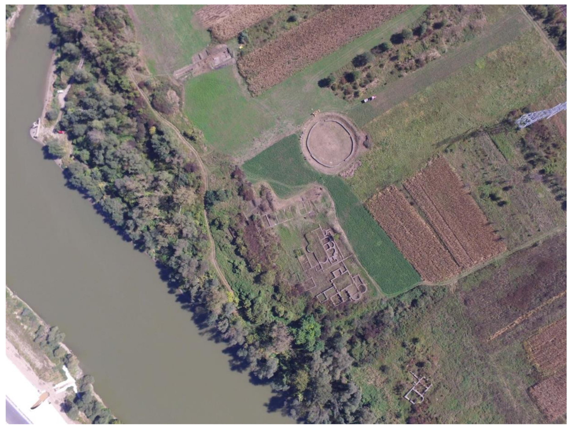
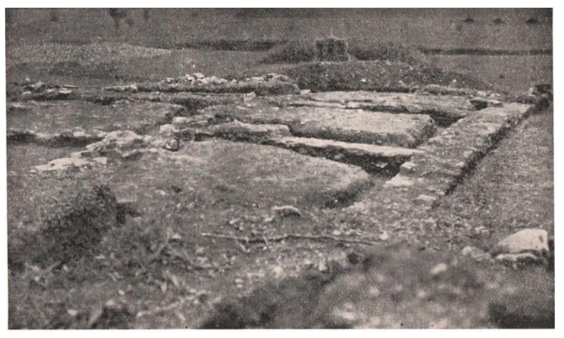
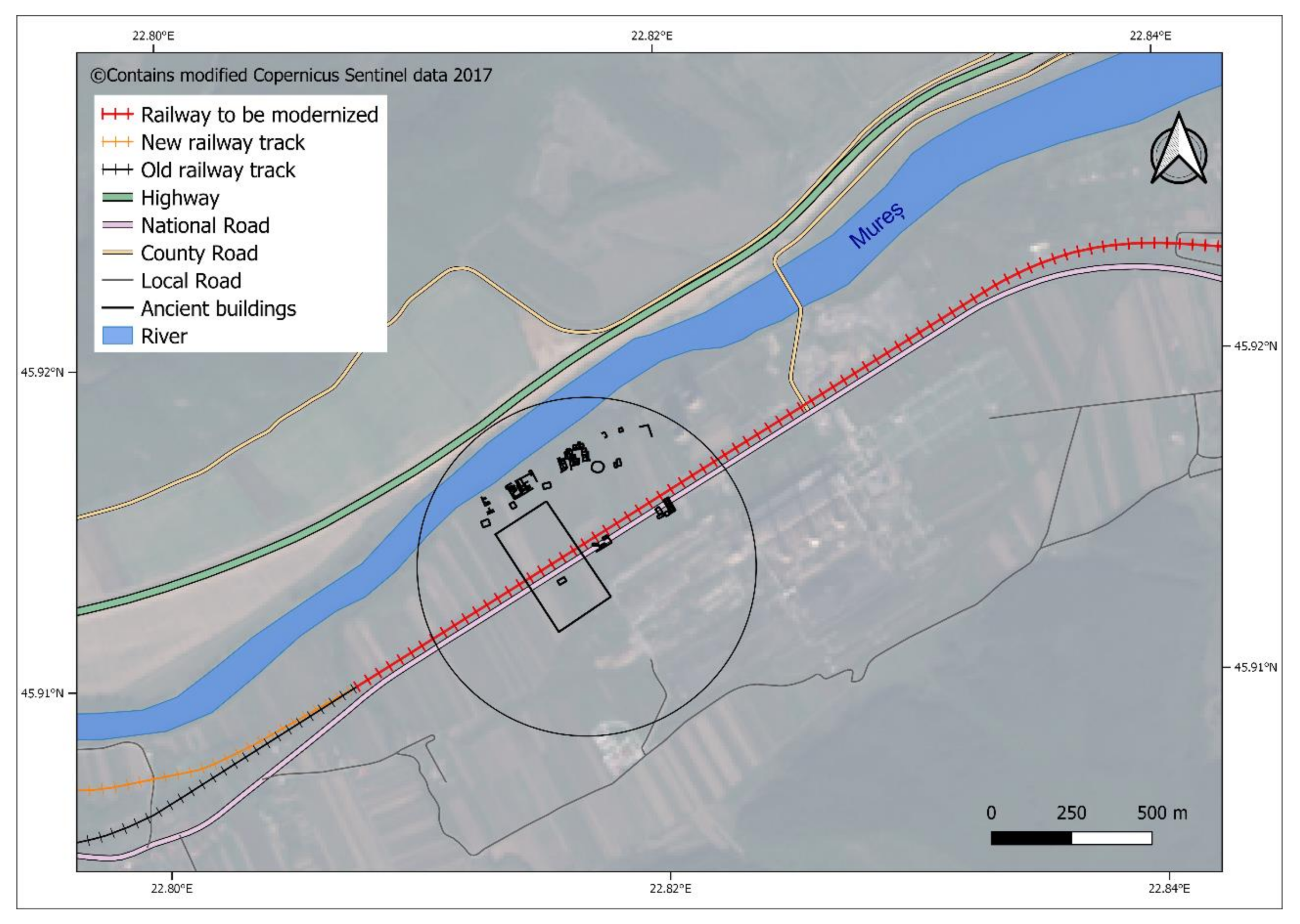
2.1.1. The Fort and the Ancient Settlement of Micia

Micia (Figure 2) is an archaeological site of national importance, ranked within category A in the List of Historical Monuments. Not far away from the town of Deva, on the left bank of the Mureș River, one of the largest forts from Roman Dacia existed in antiquity. A quasi-urban settlement was established around it, known under the name of Micia. The fort of Micia was one of the most important fortifications in the Roman province, built to control access to the Mureș Valley upstream of the Dobra Gorge [34,35,36]. The fort, the amphitheatre, the thermal complex, the civil settlement, the craftsmanship area, the sacred zones, as well as the two necropolises identified so far cover up an area of approximately 25 hectares [37]. This surface is delimited to the north by the Mureș River and to the south by the piedmonts of the Poiana Ruscă Mountains, partially overlapping the actual administrative territories of the villages Vețel, Mintia, Herepeia and Vulcez.
During the last two centuries, the archaeological site of Micia was heavily affected by public infrastructure works. The first destruction was caused by the extraction of processed stone blocks from the fortification, which were used for the construction of the Deva–Arad road and for the regularisation of the Mureș River. These activities took place in 1806 and severely affected the walls of the southern and eastern sides of the fort. Later, between 1865 and 1879, the construction of the Arad–Teiuș railway split the archaeological site along its entire length, causing major damage to the ancient military and civilian vestiges. During the communist regime, the Mintia Power Plant was built (1969–1980), resulting in the irremediable destruction of Micia’s ruins. Firstly, the former road was abandoned and a new one was built between 1967 and 1968, at short distance away from and parallel to the railway. At the same time, the construction of an industrial railway has led to the complete destruction of the southern side of the Roman camp. The modern circulation routes and the power plant’s buildings have produced massive damage not only to the fortification, but also to the ancient settlement and its associated necropolises. The intensive agriculture of the last century has contributed as well to the destruction of this Roman site [36,39,40].
The Roman remains of Micia have been noted since the 18th century, but the first archaeological investigations were undertaken at the end of the 19th century. They were performed by Johann Ferdinand Neigebaur, who dug two small test trenches on the northern side of the fort [40,41]. Large systematic studies only began in 1929–1930, under the supervision of Constantin Daicoviciu, who also excavated some test trenches on the northern side of the fort, making note on this occasion of its dimensions and the constructive evolution [42]. The archaeological excavations continued in the site of Micia in the following decades with oscillating intensity, depending on the research funds, being undertaken by teams of archaeologists from Bucharest and Cluj–Napoca, in collaboration with specialists from the Deva museum [36,39,40].
The fort is located in the river’s meadow, north–east of the locality of Vețel. The fortification was documented by small excavations or rescue interventions conducted by Daicoviciu [42] and Floca and Mărghitan [35]. However, Petculescu had a major contribution in the study of the camp during the last three decades of the previous century. Based on the collected data, it was possible to draw the plan and discover the dimensions, construction mode and erective evolution of the fortification. The playing card–shaped fort (Figure 3) has dimensions of 189.50 × 360 m (6.8 hectares), with the short sides to the south and north [36].
Archaeological research points to the existence of a first construction phase, more precisely an earthen fort, with ditch and rampart, followed by a second phase, involving the construction of a stone enclosure [35,36,39,42,44,45,46,47,48]. In the first phase, the camp had around the exterior a 2.5 m deep and 8 m wide defensive ditch and a 4–5 m wide rampart, built with earth on a timber armature (Holzerdmauer system). All the inner constructions were made of wood. This phase is documented through a layer of archaeological deposits of about one metre in depth. The uncovered materials are represented by common use pottery, but also terra sigillata, lamps, weapons, military equipment and harness items. The end of this stage was marked by a strong fire, which probably occurred when the fortification was conquered during the Marcomannic Wars (166–180) [36,39,40]. In the second phase, the fort featured a rectangular stone precinct with rounded corners, having the same dimensions as the previous earthen fortification. The wall had an opus incertum foundation of quarry stone, while the opus quadratum elevation was built using augite–andesite processed blocks brought from Uroi (municipality of Simeria, Romania). The width varied from 1.50 to 2 m, with the height being over 4 m. The rounded corners featured inner trapezoid towers and thickened masonry. The exterior ditch had considerable dimensions, some 12–15 m in width and 3–5 m in depth, respectively. The entrance to the camp ocurred through four gates guarded by towers. All the structures inside the fort were built with stone or brick, while the roads were made of stone and pebbles. It is considered that the construction of this phase ended around 204–205 and that the fort continued to exist in this form until the end of the Roman domination in Dacia [36,39,40,44,49]. The archaeological deposits of this phase were disturbed by the subsequent habitation, by intensive agriculture and by numerous modern interventions. The constructions of the road and the railway have literally sectioned the camp, the result being not only drilling through the walls, but also the destruction of its central area, particularly the headquarters building (principia).
The permanent garrison of the Micia fort was composed of auxiliary troops attested by the epigraphic evidence: Cohors II Flavia Commagenorum equitata sagittariorum, Ala I Hispanorum Campagonum, Numerus Maurorum Miciensium, etc. [34,36,39,40,43,50,51,52,53]. Together, the military effectives quartered at Micia numbered around 1500 soldiers, approximately 1100 of them being horsemen. The structure of the garrison is in accordance with the supposed enemies to be confronted in this area, namely the Iazyges from the south–west territory, a population of horsemen. Occasionally, forces from other military units were stationed in the Micia fort: Ala I Hispanorum Campagonum, Cohors Vindelicorum, Cohors I Alpinorum, Numerus Mauretanorum Tibiscensium, Numerus Germanicianorum, Numerus Campestrorum [36,39,40].
The amphitheatre (Figure 4) is placed 180 m east of the fort. The Micia edifice is a simple construction, shaped as a stone ring, with 31.60 × 29.50 m diameters [40,50,54]. Access to the arena was made through four entrances. The spectators sat down on wooden benches, the total capacity of the structure reaching almost 1500 people. The marks of the pillars supporting the timber stands have been revealed during archaeological research, outside the stone precinct of the arena. The reduced dimensions of the building suggest its classification in the military amphitheatres category, being used both for troops’ training and entertainment. Its construction is linked to the “urban” evolution of the settlement, which witnessed its peak development during the time of the Severan dynasty (193–235). The importance of this edifice is emphasised by the fact that it is only the fourth known construction of this kind in the territory of Dacia, alongside the amphitheatres of Ulpia Traiana Sarmizegetusa, Porolissum and Drobeta [55].
The excavations performed east of the fort highlighted, at a distance of 30 m north–west of the amphitheatre, the existence of the large bath complex (thermae). The first studies were performed in 1967–1968 by a team formed by specialists from the museum in Deva and the History Institute in Cluj–Napoca [49]. Starting in 1971, excavations were conducted by archaeologists from the National History Museum of Romania [56]. Four buildings (Thermae I–IV) were unearthed during the various archaeological campaigns, equipped with specific facilities: pools, lockers [37,39,40,52,56,57,58]. The excavations have demonstrated the existence of several building phases: a first one attributed to the reign of Hadrianus (117–138), followed by a rebuilding and extension of the constructions under the emperors Commodus (180–192), Septimius Severus (193–212) and Severus Alexander (222–235) [39,40,49,50,56]. The proximity of the fort and a series of epigraphic sources suggest the attribution of these constructions to the military environment, but at least one of the facilities could have been also used by the civilians.
The settlement, with the administrative rank of pagus, developed in the areas to the east and south of the fort [34,37,43,49,50,52,59]. The first research in the vicus’ area was conducted by Mărghitan [60], and afterwards by Mușețeanu [61]. The salvage excavations performed east of the fort by Mărghitan in 1967–1968, during the relocation of the Arad–Deva road, have led to the discovery of eight large buildings, with evolutive phases and complex planimetry. Their constructive characteristics, such as paved courtyards, floored chambers with mosaics, walls with polychrome paintings or heating installations, suggest a certain degree of urbanisation of the Micia settlement [60,62]. Starting in 2000, the investigations have been resumed in this point under the supervision of Petculescu [63,64,65,66,67,68,69,70]. The emergence and development of Micia’s human occupation during the reigns of Traianus (98–117) or of Hadrianus at the latest, are both archaeologically attested. The finds prove the evolution of the site from its incipient status, illustrated by earth and timber constructions, to the almost urban phase of the locality, characterised by the edification of large size stone and brick buildings (the amphitheatre, the baths, houses with central heating installations, etc.) [37,40,61]. The excavations revealed numerous constructions which can be attributed to the main existence stages of the vicus. Specific to the first phase are the buildings with timber and adobe walls, with two reconstruction levels until the middle of the 2nd century. The buildings with stone foundations and brick walls are characteristic of the second phase, dating from the middle of the 2nd century until the second half of the 3rd century. In the same area, the main road of the settlement was uncovered. It is approximately 6 m wide and was paved with lightly processed stone slabs [40,63,71]. Other secondary roads formed the street network of the military vicus [43,50,66,67]. The discovered structures served diverse functionalities, ranging from public buildings to dwellings and craft workshops [37,43,49,60,63,64,65]. Some of them fit in the so–called “strip–buildings” type, rectangular constructions positioned with the narrow side facing the road, in order to maximise everyone’s access to the street front. They were structures with both domestic and industrial functions [43]. Such an example is a bronze workshop featuring several kilns, documented inside the vicus [50,68,69,70].
A distinct manufacturing area was identified east of the fort [37]. The production of ceramic goods is attested by the discovery of five kilns, close to the Mureș River bed, which flowed much more to the south in antiquity [37,43,49,72]. Furthermore, other workshops are presumed to have functioned at Micia, such as ones for producing brooches, glass or stone working [43,59].
Based on an inscription, the existence of a raft mooring installation is presumed in the northern part of the settlement, also on the bank of the river. Additional epigraphic data make reference to the presence in this locality of a freedman of the Dacia’s salt mines and pastures administrator. Consequently, the presumed existence of such harbour facilities leads to the possibility of the presence at Micia of a customs point [34,37,40,43,49,52,59,71], in connection with the control of salt transportation, but also to the movement and account of animal flocks.
An important commercial road passed by Micia, which started from Apulum and headed west along the Mureș River, reaching Lugio in Pannonia Inferior [71]. A milliarium was also found at Micia, from the time of emperors Trebonianus Gallus and Volusianus (251–253), the inscription attesting the fact that the distance between Apulum and Micia was 45 thousand paces (approximately 67 km) [52,71].
Concerning the spiritual life, two temples have been certainly identified so far, located south of the fort [37,40,73]. The first was discovered and excavated by Floca 400 m south–east of the camp, in the point called “La Hotar”. The unearthed monuments (statues, altars) speak of the presence of a temple dedicated to Jupiter [34,37,43,51,73]. The second, identified on the basis of an epigraphic monument, is located at approximately 1 kilometre south–west of the fort, in the place called “Comoara”. The uncovered building is a three cellae temple, with dimensions of 18 × 12 m. The walls were erected in the opus incertum technique, having a width of 0.60–0.75 m. The aforementioned epigraphic monument makes note of the reconstruction of the edifice in the year 204, proving that the structure dates to the 2nd century. Based on the inscription, the building was considered from the beginning as a temple dedicated to the Mauri Gods (Dii Mauri) (Figure 5) [34,37,43,51,52,73,74]. Nemeti identifies these Dii Mauri from Micia as Mercurius Silvanus, Pluton Frugifer and Liber Pater – Shadrapa [75].
A series of archaeological finds, especially epigraphic materials, indirectly attest the existence of cult places dedicated to other divinities: Isis, Mithras, Nemesis, Hercules, Diana, etc. [34,40,43,73].
The necropolises of the settlement have been identified to the east and south–west of the fort [37,39,40,43,49]. The eastern necropolis, placed 400 m from the walls of the fortification, was more carefully researched, the majority of the funerary finds from Micia coming from this area. The first excavations were initiated at the end of the 19th century by Jung with spectacular results, if we recall only the famous aedicula found at that time, the only one entirely preserved in Dacia [40]. The first rigorous archaeological observations are credited however to Floca. He dug a small test trench in 1939, resulting in the discovery of five graves with brick walls or brick and stone walls [40,76]. Later on, during the excavations from the 1970s, the investigation of the eastern necropolis was resumed under the supervision of Andrițoiu. Most of the burials were pit cremation graves, but there were also inhumation tombs constructed with bricks, as well as stone sarcophagi. The number of the funerary features from the eastern necropolis is estimated at several hundred [40]. Moreover, numerous stone monuments have been found, such as funerary stelae, statues, medallions, and funerary lions. The inventory of the graves is scarce and consists in ceramic and glass vessels, lamps, jewellery and coins [40].
Old or recent finds point to the existence of a second funerary area, placed south–west to the camp, documented as well through the discovery of some pit cremation graves and of a group of inhumation burials [40,43,77]. Today, the only visible monuments on the surface of the Micia settlement are the amphitheatre and the bath complex.

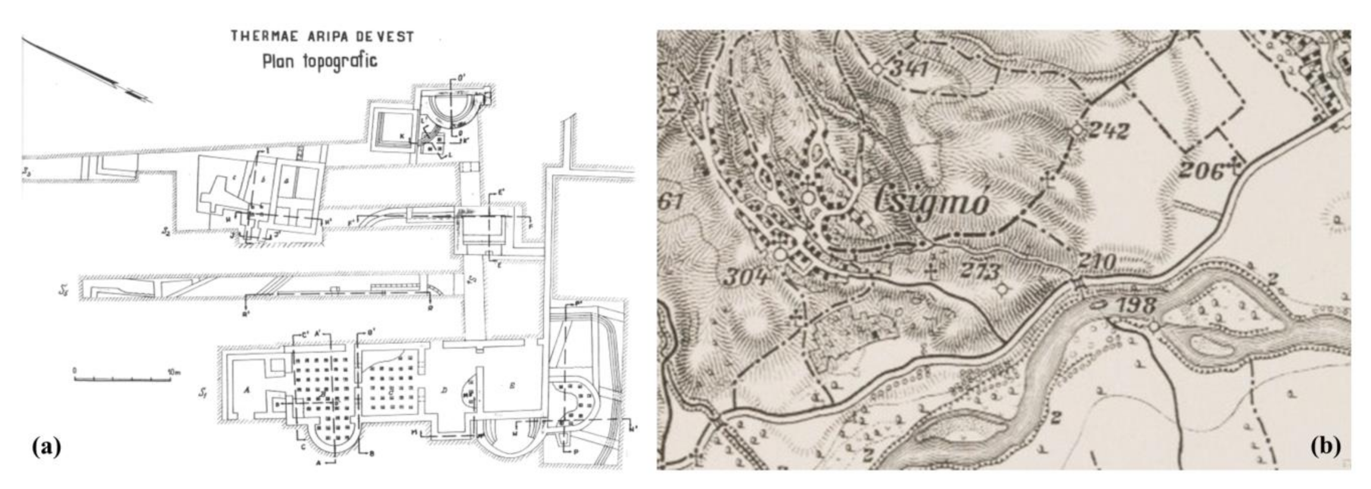
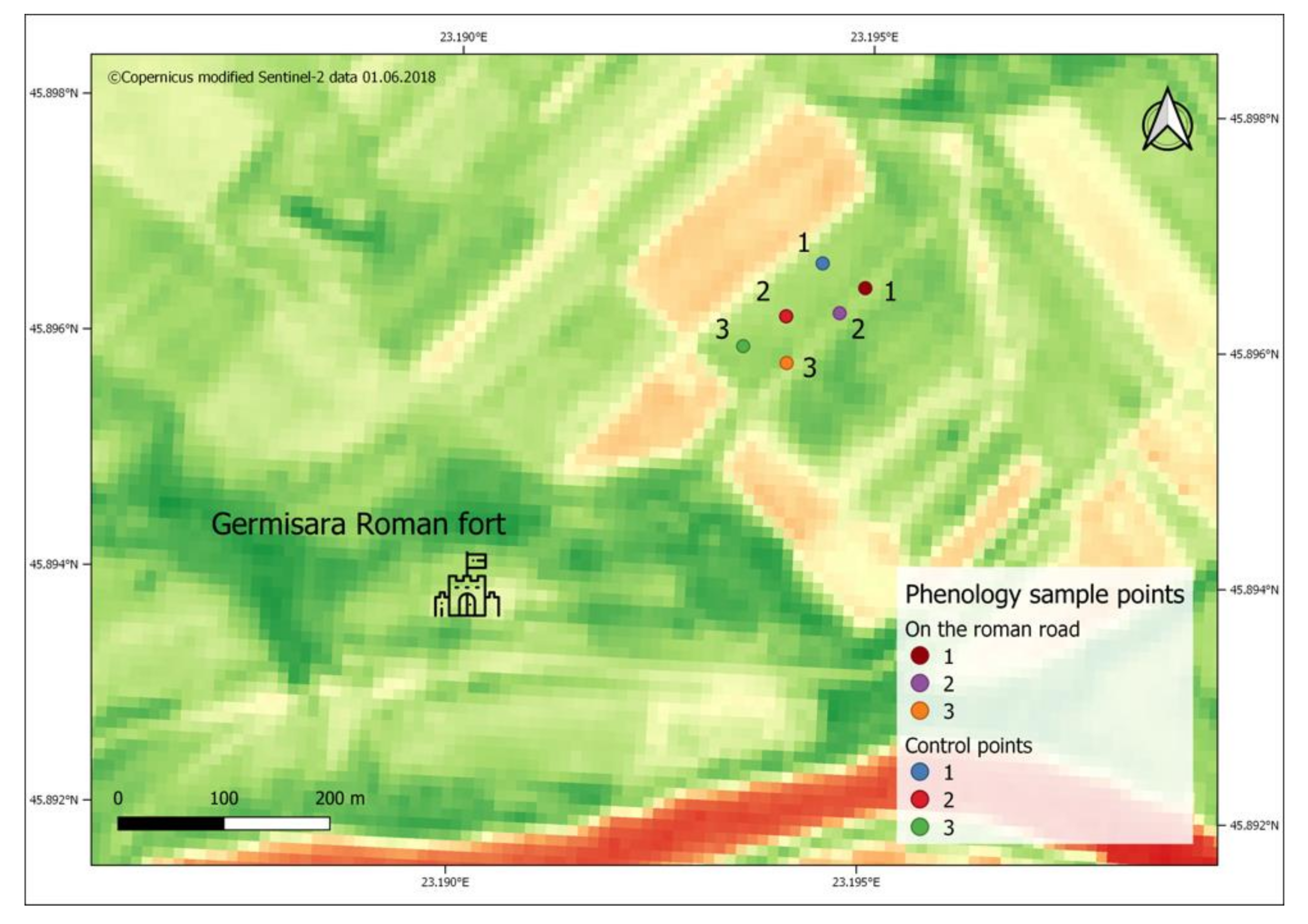
2.1.2. The Roman Fort of Germisara

Another important fortification was built by the Romans at Cigmău. The fort of Germisara (Figure 6) [53,78,79,80] was built on the right bank of the Mureș River, one of Transylvania’s most important communication routes. At this location, the southern gentile slopes of the Metaliferi Mountains meet the high terraces of the river meadows. The plateau dominated by the ancient ruins is called by the locals “Turiac” (“Turkish Hill”), while the exact place of the fortification bears the toponyms “Progadie” (“Cemetery”) or “Cetatea Urieșilor” (“Fortress of the Giants”) [78,80,81,82,83,84].
Scholars believe that the name Germisara, meaning “hot springs”, was of local origin and was linked directly to the reputed curative properties of the waters in the area [78,82,83,85,86]. The Roman locality was marked on Tabula Peutingeriana (Germithera) and in the Ravenna Cosmography (Germigera), being also mentioned in Claudius Ptolemy’s Geography (Germizera), because it was located on the main imperial road of the province, approximately half the distance from Micia to Apulum [53]. This would imply that the name referred to the camp and its surrounding settlement, but the ancient sources do not mention if Germisara was a fort, a village or a bathing facility. It should be noted that the symbol used on Tabula Peutingeriana in this case is different from the one usually employed to mark a settlement well known for its thermal facilities. In addition, there is no evidence in the respective sources for the road connecting the fort at Cigmău with the thermal complex at Geoagiu–Băi [71,82]. The ancient toponym is thus believed today to represent the military camp and the civilian settlement at Cigmău, the necropolis at Geoagiu and the thermal complex at Geoagiu–Băi [43,78,82,86].
Some authors consider that the site was also used by the Dacians, as proven by the monetary discoveries from Geoagiu: Hellenistic coins minted by Thasos, Apollonia and Dyrrachium, and Roman Republican and Imperial denarii [82,86,87]. Furthermore, it was argued that a Late Iron Age fortification functioned in the same location where the Roman fort was erected later on. The dimensions of this enclosure are presumed at 105 × 65 m in diameter, featuring a complex rampart and ditch system of approximately 25 m in width [43,87]. However, this theory is based only on the interpretation of aerial images, without any field investigations or relevant archaeological materials. Although “Dacian ceramic fragments” are reported to have been discovered at the base or underneath the walls of the principia [43,87], nothing on the subject has been published. In any case, they could be handmade cooking vessels of local tradition used by the Roman soldiers during the time of the province, just like in many other forts in Dacia [88]. In conclusion, these potsherds are not solid evidence for the present study, nor are the silver coins minted before the conquest of the Dacian Kingdom [87].
Ever since the 13th century, when the medieval church in Geoagiu was erected (which was demolished in 1930 and rebuilt in the following years, with some Roman sculptural monuments inserted in the outside faces of the walls; they are still visible today), the fort from Cigmău became a good source of quality construction materials for the nearby villagers [78,82,89,90]. A few centuries later, agricultural works continued to unearth many archaeological materials on the surface of the site. This aspect drew the attention of the 19th century scholars on the vestiges from Cigmău and Geoagiu. Their research resulted in the identification of the place with the Roman Germisara. This assumption was also supported by the epigraphic evidence, attesting to the ancient toponym and the presence of military troops garrisoned in the fort [71,78,82,85].
Buildings from the military vicus (Figure 7) can be spotted to the north and east of the camp, extending over an area of about 17 hectares, but no archaeological investigations have been performed so far [43,79,91,92]. The settlement is known in the literature under the toponym “Lunca” [83].
Authors have stated that the necropolis of the settlement is overlapped by the locality of Geoagiu [83]. This idea was plausible due to the large quantity of Roman funerary monuments reused by the villagers for the construction of their households, but mainly for constructing the medieval church [78,90]. In addition, the imperial road follows the same direction towards Apulum [71]. Nevertheless, aerial photography clearly shows that a road (Figure 8) is still visible today on a few hundred metres [93], from the Cigmău fort to the baths in Geoagiu–Băi [83,94,95], almost five kilometres away in straight line [53,71,78,80,83,96], with a clear trajectory to the north–east and that the limit of the vicus is almost 400 m away from the camp [43,91]. In this case, a presumable northern necropolis could not be too much further away and an eastern cemetery at 2–3 km, the actual distance from the fort to Geoagiu, would be too far. Thus, the exact location of Germisara’s necropolises remains debatable and requires multiple future investigations [90].
Fodor estimated the dimensions of the Roman fort from “Progadie” (the term means “cemetery” in the local dialect) at 140 × 40 fathoms (approximately 256 × 73 m) [78]. A few years later, Neigebaur mentioned a camp as well (with an earthen rampart and a deep defensive ditch), but on the “Turriak” plateau, measuring 2000 by a few hundred paces [78]. Before the start of systematic archaeological excavations, the presumed dimensions of the camp were 246.5 × 75.8 m [82,98,99]. It must be noted that at the middle of the 20th century the exact location of the fortification was still in debate and that some test trenches excavated on the “Turiac” plateau did not offer any positive results to resolve this matter [71,78,100,101].
Archaeological research was performed on the plateau of the fort starting in 2000, with notable results. They followed non–invasive magnetometry and resistivity surveys [96,102] performed in 1998 on an area of 45 × 60 m [96]. The respective research resulted in three processed images of the north–eastern corner of the fortification, with some presumed architectural elements (the walls and the north–eastern corner of the fort, a curtain tower, a possible circular structure with a diameter of almost 30 m) [102].
Systematic excavations and aerial photography revealed the (incomplete [53,92]) plan of an atypical Roman fort, determined by the topography of the terrain: an elongated raised plateau located on the ridge of the Mureș River’s high terrace [43,53,80,87,91,92,96,103]. After the first archaeological campaigns [96], it was considered that originally the camp covered a surface of approximately six hectares and that it probably measured 320 m (east–west) by 120 m (north–south) [87]. Thus it was concluded that less than half of it (the northern part) remained untouched by the landslides and floods caused by the aforementioned watercourse, the current surface of the camp being around 2.4 hectares [80,87,96].
Although this hypothesis was highly plausible [53], the actual configuration of the site and the current data support the idea that the southern wall of the fort was not destroyed by natural causes and that the military enclosure was preserved intact in the ground, following the level curves right on the edge of the plateau [53,79]. Actually the southern wall was documented through archaeological investigations in 2002 [104]. Notwithstanding, the almost trapezoidal shape of the fortification is a surprising choice for the construction of an auxiliary fort in the province of Dacia [53,105]. Nevertheless, even the ancient authors, like Vegetius for example, observed that a fort could have varied shapes, depending on the characteristics of the terrain [53].
Further excavations identified several elements of the fortification: the stone enclosure, the gates, curtain, gate and corner towers, the earthen rampart, and the exterior ditch, especially on the eastern and northern sides. The walls of the camp had a width of 1.2 m and were constructed in the opus incertum technique using processed stone blocks, probably from the nearby quarry on the left bank of Geoagiu creek [83], linked with slaked lime [87,96]. The preserved height of the western wall is 1.1 m, while the eastern ditch is at least three metres deep [96]. On the northern side, the gate tower measured on the exterior 6.60 × 4.60 m [103]. Because of the narrow space between the northern and southern curtains, the inner stone buildings (principia, praetorium, horrea, and barracks) seem to have been crowded and placed very close to each other. This is why praetentura is missing and why, in this case, via principalis is actually via sagularis [53,87]. Secondary roads and alleys, paved with rubble and sand, were connecting or delimiting the structures [104,106].
Principia (Figure 9), the headquarters building, is the main construction inside the fort, measuring 35 × 34 m and having a classic square plan. Located approximately in the middle of the fortification, it was spotted in the aerial images and afterwards excavated during several archaeological campaigns [53,87,96,104]. The outer walls measured 1.2 m in width, while the inner walls were 0.7 m wide. The entrance was identified on the southern side, measuring six metres in width. The building featured an inner courtyard (13 × 18 m) with a portico on three sides. Several chambers have been documented on the western, northern and eastern sides and they probably served as armamentaria (offices, deposits or even hallways [53,104]). One of them featured a vaulted underground chamber, probably the aerarius of the fort [53,87]. Many of these rooms had opus signinum type floors, with grounded bricks in the composition of the mortar [87,104]. Authors observed that perhaps only a part of the principia had an upper level [53]. The basilica was a 32.5 × 5 metres open space, covered with a roof and having a tribunal on the eastern side [53,104].
There is another large building [106,107], to the north of the principia, interpreted at first as a horreum [107]. The excavation is not finished, thus the dimensions of this construction are only preliminary (46.50 × 14.45 m). It appears that an earth and timber phase and a stone phase were documented until now [103]. It is interesting that several chambers with hypocaust have been unearthed [106,107]. This edifice could be the praetorium, the private house of the garrison’s commander [53,92], but further studies are needed in this respect.
At least two horrea functioned at Cigmău, west of the principia: horreum 1 measured 29 × 17.5 m and horreum 2 measured 28.5 × 10.50 m. Similar to the defensive walls of the camp, these granaries had a river stone foundation with mortar, and a quarry stone elevation, with buttresses on both sides of the walls [53,104].
It is difficult to identify in the aerial images the zone of the barracks, the living spaces of the soldiers. Archaeological excavations pointed to several areas with burnt timber structures, which could be interpreted in this direction [92,96]. An interesting cluster of buildings may be seen in the aerial images to the east of the fort [79]. They could represent the balnea, the baths for the soldiers garrisoned at Germisara. Clues of artisanal activities may only be guessed, although a large number of ceramic tiles and bricks were found on this spot. A kiln was identified in 2002 [104], a pit with bronze wastes was excavated in 2000 [96] and slag fragments were collected in 2004 [106].
Concerning the archaeological material, it was observed that the majority of the objects date after the Marcomannic Wars and that the items related to the military equipment are both diverse and numerous, with some fittings revealing a local distribution pattern [80]. Potsherds, lamps, brooches, fittings, bone tools, arrow and spear heads, bronze and silver coins, iron construction materials, glass and bronze artefacts, and stone sling projectiles have been discovered [87,96,103,104,106,107].
The epigraphic material and the stamped tiles certify the presence in the Germisara fort of pedites Britanniciani, transformed in the second half of the 2nd century in numerus singulariorum Britannicianorum [53,78,82,83,85,108,109,110,111,112], but it is also possible that vexilationes of the 13th Gemina legion participated at the construction efforts of the camp, its buildings and the thermal complex at Geoagiu–Băi [78,82,83,85,86,90,91,100,113].
The function of the Roman camp from Cigmău was to secure and control the western border, the inner territory, the communication routes, the Mureș Valley, and the gold mining region, controlling also the transportation of the precious metals and the supply of the respective area [43,78,86,110]. However, it is believed that the large number of horrea may point to a more complex functionality of the fortification [80]. Finally, it was also considered that another function of the Cigmău fort was to supervise the area of the Orăștie Mountains, as there is a direct visibility from the camp to the Dacian fortress of Costești – “Blidaru” [78]. While this assumption could be in some part true, the respective task was performed by the fort at Bucium/Orăștioara de Sus, where numerus Germanicianorum was garrisoned [101].

2.2. Satellite Imagery and Ancillary Data

2.2.1. Copernicus Sentinel–2 Imagery

The Sentinel–2 satellite mission acquires multispectral high spatial resolution optical data that enables the monitoring of the global terrestrial surfaces within the dedicated Copernicus services [114]. Sentinel–2 Multispectral Instrument (MSI) is considered to be the follow–up mission to the Landsat instruments, intended to provide continuity of remote sensing products [115].
The mission is based on a constellation of two identical satellites, Sentinel–2A and Sentinel–2B, launched separately and operated by the European Space Agency (ESA). Through the Copernicus Programme, the data acquired by Sentinel–2 are freely available. Each satellite has a swath width of 290 km enabling the global coverage of the Earth’s land surface with a revisit time of 5 days. In comparison with the latest Landsat mission composed of the Operational Land Imager (OLI) and the Thermal Infrared Sensor (TIRS), Sentinel–2 has better spatial resolution, better spectral resolution in the near infrared region, four narrow bands in the visible–near infrared (VNIR) Vegetation Red Edge bands, but it does not include thermal or panchromatic bands [116].
Sentinel–2 offers satellite images with a spatial resolution of 10 to 60 m [117]. The classical red–green–blue (RGB) bands and a near infrared (NIR) band have 10 m spatial resolution, the four VNIR Vegetation Red Edge and the two short wave infrared (SWIR) bands have 20 m spatial resolution, while the coastal aerosol, water vapour, and cirrus bands have 60 m pixel size (Table 1). However, considering the four fine spectral resolution bands, a panchromatic band can be produced for obtaining ten fine spatial resolution bands through Sentinel–2 image fusion [118].
For the present study, Sentinel–2 products from 2016 to 2019 were accessed and downloaded using the Copernicus Open Access Hub, available at https://scihub.copernicus.eu/. This is the dedicated platform where Top–Of–Atmosphere (TOA) reflectance products in cartographic geometry (Level–1C) are regularly published by ESA very soon after the acquisition of the raw images. Since April 2017, the Bottom Of Atmosphere (BOA) reflectance in cartographic geometry (Level–2A) products are also published 48–60 hours after the Level–1C products [119].
Based on automated processing with the Sen2Cor processor, Level–2A Sentinel products were obtained. Sen2Cor is a Level–2A processor with the main purpose of correcting the effects of the atmosphere in single–date Sentinel–2 Level–1C TOA products in order to generate Level–2A BOA reflectance products. Level–1C processing comprises of radiometric and geometric corrections, including orthorectification and spatial registration on a global reference system with sub–pixel accuracy. Sen2Cor outputs are provided for spatial resolutions of 60 m, 20 m and 10 m. The Level–2A processing also includes a Scene Classification and an Atmospheric Correction applied to TOA Level–1C orthoimage products. Level–2A main output is an orthoimage BOA corrected reflectance product. Presently, the Sen2Cor processor available as a third–party plug–in of the Sentinel–2 Toolbox enable users to generate Level–2A products [120].
In addition, Level–2A Sentinel–2 images available through Google Earth Engine © provided by Gorelick et al. [121] were used. Overall, the dataset contained 73 Sentinel–2 images that cover the archaeological sites of Micia and Germisara. As mentioned before, the Sentinel–2 data were acquired in a time frame of three years.
According to De Laet [122], in some situations, ancient structures are not apparent from ground level, but become evident when using Earth Observation techniques. Sentinel–2 imagery is useful for the monitoring of the vegetation that surrounds or covers archaeological features, even in the case of small–scale components. The spatial resolution of 10 m in the visual and near–infrared bands allows for the monitoring of the overall vegetation status at the site level using vegetation indices. Moreover, Agapiou et al. [123] highlighted the benefits of the five–days revisit time that enables the elaboration of seasonal time series of observations.

2.2.2. CORONA Archive Imagery

CORONA (designated KH–1, KH–2, KH–3, KH–4, KH–4A, KH–4B from KeyHole–KH) strategic reconnaissance satellites that operated from 1960 to 1972 provided historical information for the USA. KH–1, KH–2 and KH–3 carried one panoramic camera, while KH–4, KH–4A and KH–4B carried two panoramic cameras, one looking forward and the other one looking backward [124]. The ground resolution of the images ranges between 1.83 m and 2.74 m with a high response in the visible spectrum range [125]. The CORONA images were made available for civil access and published within three editions, in 1996, 2002 and 2013 [126]. Currently, the archive satellite images can be successfully used in archaeology enabling the specialists to analyse and better understand how people lived in the past and how the landscape changed over time [127]. In this study, an archive CORONA image was downloaded from the United States Geological Survey (USGS) platform, available at https://earthexplorer.usgs.gov.

2.2.3. Romanian Maps under the Lambert–Cholesky (1916–1959) Projection System

These maps contain processed data derived from Romanian, Austrian and Russian previously executed measurements. Depending on the scale of the map, the relief was illustrated using contour lines with an equidistance of 20 m for the 1:20,000 scale, respectively 100 m for the 1:100,000 scale. In Romania, the need for a new datum, a new projection system and a new nomenclature arose during the World War I, in order to create an unitary cartographic projection for the entire territory and also comply with the principle of conformity [128]. In the context of the present study, the maps provide useful information about the Mureș River before the regularization of its course that was made with the purpose of constructing the Mintia power plant.

2.2.4. Other Ancillary Data

The remote sensing analysis was supported by numerous graphic materials (Figure 10) provided by the Museum of Dacian and Roman Civilisation (MCDR), such as old and new photographs of the archaeological sites, drawings of reconstructed elements or buildings, archive topographic maps, topographic measurements, aerial photographs, drawings of the archaeological features, location of the archaeological campaigns as well as a wealth of historical information and descriptive notes.

2.3. Methodology

The study has two main objectives, namely: (1) identify and assess the potential risks that might endanger the Micia and Germisara archaeological sites and (2) evaluate the suitability of remote sensing vegetation indices for the detection of potential underground archaeological features.
With reference to the first objective, the risk of cultural heritage site damages linked to natural processes or human actions was estimated using an integrated analysis of remote sensing and ancillary data. In case of the Micia archaeological site, the investigation started with the inventory of the previous geo–hazards and anthropogenic risks, followed by the thorough documentation and mapping of the site landscape evolution in time. The exposure to specific risks was estimated by also incorporating the mapping of the surrounding infrastructure (e.g., the railway, national road and highway) and the analysis and modelling of the elevation. The hazard risk mapping for the Germisara archaeological site mainly focused on the exploitation of the elevation data.
The concept underlying the second objective evolved from the wide recognition of satellite remote sensing as a non–destructive tool for uncovering archaeological landscapes [129]. Some archaeological features are buried over the years leaving some traces above ground with a specific shape, size and pattern [130]. The methods proposed in this paper can be applied for the assessment of different heritage sites. For the monitoring of the archaeological heritage sites and the detection of buried archaeological features, several spectral indices and various combinations of spectral bands were tested. Specifically, the Normalized Difference Vegetation Index (NDVI), the Simple Ratio (SR) vegetation index and the Normalized Difference Water Index (NDWI) were derived from Sentinel–2 data and their suitability was validated based on the available ancillary data.

3. Results and Discussion

3.1. Hazard Risk Identification

The cross use of old maps and contemporary satellite imagery for assessing the different aspects of the landscape that changed during multiple decades, centuries or even millennia is a widely used method [126,131]. This type of analysis supports the understanding and mitigation of geological and geomorphological processes or human–induced threats for safeguarding the archaeological heritage. In this case study, three types of available data that enabled the reconstruction the Mureș riverbed were used, namely: (1) Romanian maps under the Lambert–Cholesky (1916–1959) projection system, at scale 1:20,000 dated 1926; (2) Corona image dated 17 August 1968; (3) Sentinel–2 multispectral imagery from 2018. Both the satellite images and the map were reprojected in the World Geodetic System 1984 (WGS84) datum, Universal Transverse Mercator (UTM) zone 34N (EPSG: 32635) Coordinate Reference System. By comparing side–by–side the three data sources, the changes that occurred in the landscape of the cultural heritage site and its surroundings could be identified and examined. In this manner, the extensive and permanent damage caused by the construction of the Mintia Power Plant and the damming of the Mureș River could be clearly observed. In 1967, the Micia Roman fort was affected when the flow of the Mureș River was diverted and sank part of the ruins. The vectors representing the riverbed at certain moments in time (i.e., 1926, 1968 and 2018) were extracted from the abovementioned data sources and overlaid on the Sentinel–2 image. The resulted product (Figure 11) reveals the changes in the natural river flow that can still pose a future threat for the Micia cultural heritage site.
Micia Fort is located on one of the most important routes that link Transylvania with Central Europe. The location of the fort was of high importance both in the Roman antic period and also during medieval times. Nowadays, the area is even more important for the economy due to the increasing quantities of cargo and traffic through the valley. The valley section where the Micia Fort is located is about 1.8 km wide. It is crossed by a series of major infrastructure projects (Figure 12) that led to the degradation or permanent damage of the cultural heritage site. The major projects are: (1) railway constructed between 1865 and 1879, (2) national road number 7, (3) Mintia Power Plant built in the 1960s that was erected on top of the north–eastern part of the cultural heritage site, (4) construction of the highway on the northern bank of the Mureș River.
In 1869, the construction of the Deva–Arad railway started, which crossed the ruins of the ancient settlement, thus affecting part of its remains. The railway is part of the Rhine Danube corridor, now in the process of modernization in order to accommodate high–speed trains. The modernization project will consist in the widening of the railway footprint, for the creation of a larger embankment. Because the railway was initially designed to cut straight through the middle of the cultural heritage site, the modernization works will further destroy parts of it. Therefore, the current project of the railway rehabilitation will cross the entire ensemble, over a length of two kilometres, right through its central part. Also, the Roman fort area will be passed through by the modernized railway, across its entire width, from east to west, thus almost divided in half. In this way, an area of great importance within the Micia archaeological site will be affected.
For the construction of the highway, the consolidation of the river bank was performed by building a concrete wall that had the role of protecting it from the river’s erosion. In consequence, in the future, it is possible that the lateral erosion process to concentrate on the opposite river bank, where the bank materials’ composition is less cohesive [132]. Furthermore, the presence of the Mintia Power Plant dam changed the river stretch natural flow. Sediments transported by the river are blocked upstream of the dam, thus the water that flows downstream is more sediment free, but with a higher capacity of sediment transportation [133]. In certain scenarios of evolution, these combined factors can pose significant risks for the cultural heritage site.
In the second case study, the main geo–hazard that was identified for the Germisara archaeological site is represented by soil erosion. In general, soil erosion is a significant geophysical hazard for cultural heritage sites [134]. Erosion reduces the thickness of the top soil and exposes the archaeological features to other types of degradation [135]. Erosion is more intense in sloped areas where practices such as agriculture and grazing are present. The position of Germisara Roman Fort is depicted in Figure 13. The map was created by interpolating the contour lines extracted from the Romanian topographic map, scale 1:25,000. The resulted digital elevation model (DEM) was processed into a slope map and reclassified according to Grigore [136]. The processing was made using Quantum Geographic Information System (QGIS) software, version 3.4.
The results demonstrate that a large part of the cultural heritage site lays on surfaces with slopes that have values in the range of 3–10 degrees. In this situation, plowing must be done parallel to the elevation contour lines in order to minimize the effects of surface wash erosion [136]. Moreover, the presence of small river valleys in the proximity of the cultural heritage site indicates the possible existence of erosional formations like gullies and ravines, which may endanger parts of the site.

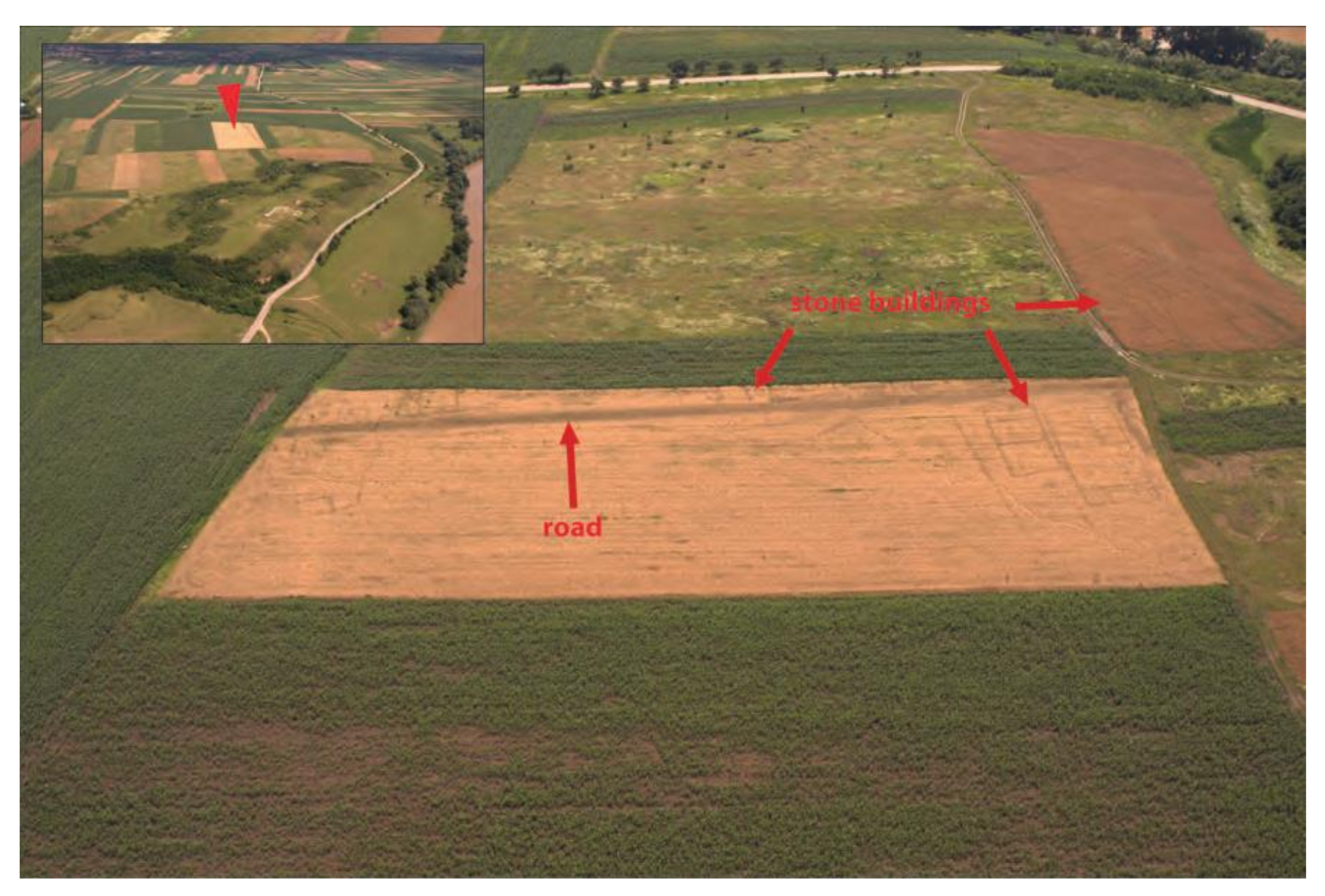
3.2. Identification of Underground Archaeological Features Using Remote Sensing Vegetation Indices

NDVI is the most widely used remote sensing vegetation index [137]. It was developed to increase the performance of the Simple Ratio (SR) vegetation index [137,138] developed by Jordan [138]. It can be used in a large number of applications such as measuring plant coverage, biomass or vegetative vigour [139]. Furthermore, NDVI is considered to be the most used vegetation index for space archaeology [123]. NDVI is obtained using the combination of the visible red and NIR spectral bands and it is based on the concept that the radiation in the region of the visible red band (RED) (0.63–0.69 µm) is absorbed by the chlorophyll in the leaves, while the radiation in the region of the infrared (IR) (0.76–0.90 µm) is reflected [140]. NDVI is calculated with the following formula:
NDVI = (NIR − RED)/(NIR + RED)
As a result, the NDVI values range between −1 to 1. The highest value of about 0.90 corresponds to areas with maximum density of vegetation (e.g., forests) that consequently correlates with a high content in chlorophyll. Usually, NDVI values vary between 0.05 and 0.60 with negative values for clouds, snow and ice [141].
Red and NIR were two of the four spectral bands of the ERTS–1 (Landsat 1) satellite mission that paved the way for crop monitoring, yield predictions and biomass estimations [142]. Presently, a large number of Earth Observation satellites are equipped with sensors that acquire data in the RED and IR spectrum, thus enabling the cross analysis of the NDVI values generated from measurements performed by various satellites and instruments. The previous studies that operated with NDVI values derived from data acquired by Sentinel–2 MSI indicated a good correlation with the in–situ data, in the field of space archaeology. The 10 m spatial resolution of the Sentinel–2A and Sentiel–2B corresponding to Band 4 (Red) and Band 8 (NIR), offers sufficient details in order to detect crop signatures that reveal ancient constructions.
Plant phenology is the study of plants’ lifecycles. The first observations of plant phenology probably were performed as soon as humans started to grow crops [143]. Starting with the medieval period, the interest in natural science was revived in Europe. During the 19th century, the amount of data gathered by botanists enabled the creation of the first phenological map of Europe [143]. Nowadays, thanks to the data obtained by Earth Observation satellites, the plants vegetation stages can be closely monitored within all the seasons. Reliable time–series of vegetation indices derived from satellite remote sensing data are essential for monitoring vegetation patterns [144]. Satellite images collected for large areas and for many years in a row facilitate the creation of phenological maps for vast regions, even for continents. The increase in spatial and temporal resolutions offers an unprecedented view of the plants growing cycles.
Plant growth is directly influenced by the soil structure [145]. An ancient underground structure like a wall or a road influences the soil structure [11,146,147]. The presence of underground structures restricts the evolution of the plants in the soil by preventing the roots from developing normally [130]. The lack of nutrients and water compared to the surrounding areas further stresses plants. By calculating the vegetation indices, these areas can turn out with lower vegetation values. This phenomenon was previously evaluated and published in multiple studies concluding that the differences in soil structure influence the soil moisture [11,146,147]. This contributes to differences in vegetation stages that can be observed in NDVI values [11].
The NDVI output for the Germisara Roman Fort indicated a good performance in exposing cropmarks in one affected parcel. The resulting NDVI product (Figure 14) shows that the crops that are growing above the Roman road are stressed compared to the ones from the rest of the parcel. The difference between the NDVI values for the two types of pixels (above and near the ancient roman road) are highlighted in Figure 15 that presents two relevant cross–sections. The Roman road remains clearly impact the crop biomass and vigour, as the NDVI output indicates. Hence, this phenomenon appears due to the ancient remains that are affecting the crop growth. In the months with dense vegetation, the NDVI values are lower due to the stressed vegetation that grows above the ancient road.
The case study regarding the Germisara Roman Fort continued with the processing of the Level–2A Sentinel–2 MSI images available through the Google Earth Engine© [121]. The Earth Engine was accessed via the Core Editor, which is a web–based Integrated Development Environment (IDE) that runs JavaScript. For the present case study, a custom script was created inside the Core Editor. The NDVI time–series were calculated in a matter of seconds thanks to the cloud processing resources [121]. As a result of the 5–days revisit period at the equator, a total of 68 cloud free images, covering the area of interest were used. For the analysis, the NDVI of six points from the same parcel were compared. The first set of points (geographic coordinates WGS84 datum: point 1—longitude 23.19494⁰, latitude 45.89649⁰; point 2—longitude 23.19465⁰, latitude 45.89628⁰; point 3—longitude 23.19401⁰, latitude 45.89584⁰) was positioned on the Roman road from the Cigmău fort to the baths in Geoagiu–Băi (located at almost five kilometres from the Roman fort), while the second set of points (geographic coordinates WGS84 datum: point 1—longitude 23.19442⁰, latitude 45.89669⁰; point 2—longitude 23.19399⁰, latitude 45.89623⁰; point 3—longitude 23.19348⁰, latitude 45.89598⁰) in the middle of the parcel, in a spot with healthy vegetation and good soil structure (Figure 16).
The results were exported in comma–separated values (CSV) format and displayed in Microsoft Excel in Figure 17. Differences between the NDVI values can be observed during the vegetation cycles for all the study years (the satellite images acquired during the winter season were excluded). In 2017 and 2019, according to the phenological evolution, the parcel has been cultivated with maize. The vegetation values are higher in the control area compared with the ones located above the Roman road. By examining the vegetation curve of 2018, it can be concluded that the parcel was cultivated with sunflower. In this situation, the vegetation values were higher above the Roman road and lower in the test area. The differences in crop growth patterns clearly indicate discrepancies in soil composition and moisture. It is a testimony of the existence of ancient underground structures. This assumption is backed by the studies conducted by Oltean [43] that identified the Roman road when studying the aerial photographs of the Cigmău archaeological site and its surroundings.
In general, as plants develop, the spectral response in the Red band decreases, while in NIR increases. The spectral bands used to calculate vegetation indices are chosen such that one decreases and the other increases with the development of vegetation cover. Two general classes of vegetation indices, i.e., ratios and linear combinations, both exploiting the surface-dependent or wavelength-dependent features, are described in the scientific literature. In what concerns the first class, the ratio vegetation indices are determined based on the ratio of two spectral bands. Besides this simple formula, the ratio vegetation indices can also be computed using the ratio between the sums, differences or products of more bands. Regarding the second class, the linear combination implies the use of any number of spectral bands that represent input data for the corresponding number of linear equations [138,148]. The SR vegetation index has the following formula:
SR = NIR/RED
Vegetation indices were developed with the scope of increasing vegetation characteristics and at the same time minimize the other contributing factors (e.g., the background reflectance of the soil or the effects of the atmosphere) [149]. For the Roman Fort of Germisara, the traces of the road from the Cigmău fort to the baths in Geoagiu–Băi were also identified based on the analysis of the SR image output (Figure 18), where high values represent vegetation and low values indicate soil.
In the context of cultural heritage site condition assessment and monitoring, and detection of underground structures, the performance of NDWI was also determined. NDWI is sensitive to the moisture content of the plants and soil. According to Gao [150], this index is used to monitor changes in water content of leaves, using NIR and SWIR wavelengths. Hence, NDWI is a good indicator of vegetation liquid water content, while being less sensitive to atmospheric scattering effects than NDVI. The formula of NDWI is:
NDWI = (NIR − SWIR)/(NIR + SWIR)
According to McFeeters [151], NDWI pinpoints the cases of lower correlation between bands. By comparing the reflectance of water in various spectrum portions, McFeeters [151] came to the conclusion that water reflects higher in the Green spectral band against the Red and NIR bands. The proposal for the NDWI occurred after the correlation between the Green and the NIR bands with the aim of better identifying water features. Thereby the NDWI equation is [151]:
NDWI = (GREEN − NIR)/(GREEN + NIR)
Hence, in order to distinguish as clearly as possible the characteristics of the area of interest, NDWI uses the values of reflectance in the Green band to identify the water component and the ones in the NIR band to identify the vegetation and soil component. The result is that NDWI differentiates the scene components in two intervals of values, specifically positive for water and negative for vegetation and soil [151]. The study demonstrated that NDWI values range from –1.0 to +1.0 and the index depends on the leaf water content as well as the vegetation type and cover [151].
Furthermore, Arekhi et al. [152] also demonstrated that NDWI varies from –1.0 to +1.0 depending on the coverage and vegetation type. Vegetation may present higher water content, therefore high values of NDWI. The index has low values in periods of water stress.
According to De Guio [153], the phenological and biophysical cycles can expose important aspects regarding the buried archaeological features. By using multispectral images and analyzing the differences that appear from one cycle to another, it can be observed that vegetation develops differently when underground archaeological remains are present.
In the case of Micia Roman fort, in order to identify the presence of underground structures, NDWI was calculated using the Sentinel–2’s NIR and green spectral bands. As mentioned before, the index measures the crop moisture, which indirectly might suggest the presence of buried structures. The use of satellite imagery acquired during the summer season is not recommended because the vegetation is dense. The best results were obtained when using satellite imagery from the autumn season, i.e., November 2016 and October 2018, due to the bare soil. For the same geographic area, the underground structures detected using NDWI can be identified in Google Earth imagery (Figure 19).
It is well known that remote sensing multispectral images contain information acquired by sensors that detect electromagnetic energy in different regions of the spectrum. This wealth of data is exploited in order to also observe wavelengths that the human eye cannot see and consequently to better detect different aspects of the landscape. For example, certain false color composite images enable the effortless identification of areas covered by vegetation.
In this paper, a false colour composite was created using the NIR, Red and Green spectral bands of the Sentinel–2 image (Figure 20), each as input for the Red, Green and Blue channels, respectively. The natural colour composite created using the Red, Green and Blue bands of the visible spectrum does not offer relevant and fine information for the archaeological sites [130].
Vegetation reflects in the NIR band and absorb in the Red band, hence providing useful information about vegetation in what regards its presence or absence as well as growth and health status. This specific information is enhancing the cropmarks for archaeological purpose [154].
The changes caused by archaeological sites to local vegetation growth can be distinguished in differential remote sensing analyses. The multispectral imagery has the capacity to reveal the difference between natural and anthropogenic features within landscapes [155].
The results of the study show that satellite imagery contributes to the risk identification for cultural heritage sites. By the combined use of Sentinel–2 and other geospatial data, and also by integrating the knowledge on the evolution of the cultural heritage sites and their surroundings, the current hazards that might threaten the integrity of the sites could successfully be determined. The analysis of the risks was complemented by the study of the natural environment of the Micia and Germisara sites for the detection of underground archaeological features. The spatial and spectral resolution of Sentinel–2 proved to be adequate for the detection of the buried remains, although the interpretation of the results was supported by the available cartographic materials considering the reduced size of some archaeological features. With reference to the performance of the remote sensing vegetation indices, without ancillary information some features might be confused with other elements that have a similar appearance or index value, thus being overlooked within the general scene. On the other hand, the use of different vegetation indices and spectral band combinations increased the accuracy of the detection results.
Future research directions involve the integration of higher spatial and spectral resolution satellite imagery that could improve the detection not only of the known remains, but also of the potential undiscovered features. Firstly, a higher spatial resolution could enable the detection of smaller–sized archaeological remains [156,157,158,159]; secondly, a higher spectral resolution (e.g., hyperspectral satellite data) could allow the unequivocal identification of the covered archaeological structures [160,161]. In addition, another potential research direction is represented by the use of (semi–)automatic methods for archaeological feature detection, as the scientific literature contains plentiful studies that demonstrate the benefits of these methods for archaeological cultural heritage [162,163,164]. Such approach would be beneficial especially when supplementary information (e.g., cartographic documents showing the display of the archaeological features) is not available. In this way, the features that might be easily disregarded during the visual image interpretation based on different spectral band combinations could be unequivocally detected.

4. Conclusions

This study demonstrates that Sentinel–2 imagery is valuable for cultural heritage sites’ hazard risk identification. For the investigated archaeological sites, i.e., the Roman fort at Micia and the Roman fort of Germisara, the hazards that might damage their structure were identified. The analysis showed that both sites are exposed and vulnerable to hazards due to the degradation processes caused mainly by anthropogenic factors. The study focused on the evolution of the sites’ landscape over a long time period (i.e., starting in 1926, in the case of Micia) by using historical cartographic materials, archive satellite imagery and other types of ancillary data.
Down the centuries, the Roman fort of Micia was affected by human activities more than natural environment changes. Since 1806, the Micia fort has been seriously affected by major infrastructure projects. Firstly, many archaeological stones were taken for the construction of the national road between Arad and Deva and for the regularization of the Mureș River. In that time, a great part of the archaeological site was affected, principally the southeastern walls of the Micia fort. Afterwards, the construction of the Mintia power plant, between 1969 and 1980, caused an irremediable destruction of the Micia fort remains. At the same time as the construction of the power plant, a dam was built on the Mureș River. The lake formed behind the dam caused the rise of the local base level for the upstream part of the river course that consequently led to the modification of the river’s natural flow. Moreover, in the same period, the construction of an industrial railway destroyed the south part of the archaeological site. Hence, these man–made activities have strongly affected the Micia fort and caused immense damage to the archaeological heritage. Last but not least, the Micia site is affected by intensive agricultural works. The study of the past events and experiences provided a very useful in–sight in order to qualify the exposure of Micia to risks.
In order to identify the potential human–induced hazards that the Micia fort could be exposed to in the present times, the study focused on the impact of the railway modernization project. The entire archaeological site will be crossed from east to west, over a length of approximately two kilometres, by the rehabilitated railway. Hence, the infrastructure project will further damage the Micia fort. In addition, the Mureș River might increase specific geo–hazard risks for the cultural heritage site due to the change of the river flow that could cause larger sediment deposits on the river bank where the site is located.
Presently, the Roman fort of Germisara is prone to soil erosion. The analysis of the Sentinel–2 images in conjunction with the elevation data showed that this geo–hazard might endanger a large part of the archaeological site by exposing its features to other types of physical degradation.
The research proves that satellite–derived information greatly contributes to the preparedness and mitigation phases of the disaster management cycle. By accurately knowing the past and current hazards, exposure and vulnerability of each monitored cultural heritage site, a more effective disaster risk management might be carried out by the authorities in charge with safeguarding. The preventive and corrective actions that are implemented in a timely manner might considerably reduce the damages. Thus, risk prevention and satellite–based monitoring of the cultural heritage sites and their surrounding landscapes are essential for cultural heritage preservation. Furthermore, with reference to the disaster management cycle, satellite imagery already proved its benefits, in particular for the response phase as well as for the recovery phase. With this valuable information provided by the satellites, the improved management of the cultural heritage sites is based on qualitative and quantitative assessments.
In the context of cultural heritage, satellite imagery is likewise useful in the detection of sub–surface structures. In the present study, different remote sensing vegetation indices (i.e., NDVI, SR and NDWI) and combinations of spectral bands were used to detect and highlight the presence of underground cultural heritage features in order to support and enhance the study regarding the hazard risk identification.
The NDVI–based phenology analysis confirmed its usefulness in cultural heritage monitoring. The evolution of the vegetation within and around the archaeological site of Germisara was based on Sentinel–2 images acquired during the summer season. The crop growth is influenced by the presence of the underground structures. In these cases, the crop growth discrepancies are correlated with differences in soil composition and moisture. In addition, the NDVI output values for the Roman road from the Cigmău fort to the baths in Geoagiu–Băi indicate that the crops growing above the road are stressed in comparison with the ones from the rest of the crossed parcel. SR also proved its efficiency in identifying traces of the Roman road within the Sentinel–2 imagery. Based on satellite images acquired also during the summer, the low SR values indicated portions of the covered Roman road. Next, NDWI performance was estimated based on Sentinel–2 imagery from autumn. The index enabled the identification of the North–East wall of the Micia Roman fort. Overall, the results confirm the importance of vegetation for understanding spatial variations in archaeological areas. As intensive agriculture is affecting both the Micia and Germisara Roman forts, the remote sensing vegetation indices exploited in this study identified the abnormal areas of cultivated crops, thus indicating the existence of underground archaeological remains.
The information obtained through the analysis of a specific false colour composite of the NIR, Red and Green spectral bands also proved to be meaningful for identifying the wall of the Micia fort. The Sentinel–2 false colour image highlighted distinct cropmarks that indicated a clear correlation with the underground structures.
One of the main limitations of the study was represented by the size of archaeological features that are composing the investigated cultural heritage sites and for this type of features, the 10 m spatial resolution of the VNIR bands could be considered too coarse for some in–depth investigations. The cropmarks and soil marks are not constantly visible due to the specific vegetation phenology. For this study, Sentinel–2 data provided great advantages, namely the possibility to use satellite images acquired in a very short time frame (i.e., a few days) and the capability to combine the spectral responses in order to obtain additional information from the various remote sensing vegetation indices. Of high importance is also the free, full and open access to Sentinel–2 data as provided through the Copernicus Programme that enabled the analysis of large and temporally adequate datasets for the Micia and Germisara Roman Forts.
In conclusion, the study provides evidence that Sentinel–2 spatial resolution is suitable to support archaeological studies by enabling the risk identification as well as the accurate monitoring of the sites. In order to complement the results, alternative approaches that integrate spatial high–resolution multispectral satellite images might be used for future research. In addition, hyperspectral satellite imagery might provide relevant information for the detection of underground structures. Also, automatic archaeological feature detection might be conducted in the follow–up of the present research. Nevertheless, the correct interpretation of the satellite–derived results requires an exhaustive knowledge of the investigated archaeological sites. In this context, the expertise of the specialists involved in the management of cultural heritage is fundamental for a better interpretation and analysis of the remote sensing results. Hence, interdisciplinarity in the scientific assessment and monitoring of the cultural heritage sites is proving to be of great importance also regarding the value of research based on EO technologies.

Author Contributions

Conceptualization, I.D.N., C.M. and A.M.L.; methodology, A.M.L., C.E.M. and A.L.D.; writing—original draft preparation, I.D.N., A.M.L., N.C.R., C.C., C.E.M. and A.L.D.; writing—review and editing, I.D.N., C.M. and A.B.; supervision, A.B. All authors have read and agreed to the published version of the manuscript.

Funding

This work was supported by a grant of the Romanian Ministry of Research and Innovation, CCCDI – UEFISCDI, project number PN–III–P1–1.2–PCCDI–2017–0413/contract number 50PCCDI/2018, within PNCDI III.

Conflicts of Interest

The authors declare no conflict of interest.

References

  1. PricewaterhouseCoopers—PwC. Socio—Economic Impact Assessments and Accompanying Foresight Study of Selected ESA Earth Observation Activities. Available online: http://esamultimedia.esa.int/docs/business_with_esa/ESA_EO_activites_Impact_Assessment_Executive_Summary.pdf (accessed on 10 September 2019).
  2. Probst, L.; Frideres, L.; Cambier, B.; PwC Luxembourg; Duval, J.P.; Roth, M.; Lu-Dac, C.; PwC France. Applications related to Earth Observation. In Space Technologies and Services; European Union: Brussels, Belgium, 2016. [Google Scholar]
  3. UNESCO—Culture—World Heritage Centre: About World Heritage. Available online: https://whc.unesco.org/en/about/ (accessed on 2 February 2020).
  4. UNESCO—Culture—World Heritage Centre: World Heritage in Danger. Available online: https://whc.unesco.org/en/158/ (accessed on 2 February 2020).
  5. EURISY: Satellites Going Local—Culture Edition 2019–2020. Available online: https://www.eurisy.org/data_files/publications–documents/48/publications_document–48.pdf?t=1574173470 (accessed on 10 March 2020).
  6. Lasaponara, R.; Masini, N. Advances on Remote Sensing for Archaeology and Cultural Heritage Management, 1st ed.; Aracne: Rome, Italy, 2008. [Google Scholar]
  7. Elfadaly, A.; Attia, W.; Qelichi, M.M.; Murgante, B.; Lasaponara, R. Management of Cultural Heritage Sites Using Remote Sensing Indices and Spatial Analysis Techniques. Surv. Geophys. 2018, 39, 1347. [Google Scholar] [CrossRef]
  8. Stubbs, J.H.; McKee, K.L. Applications of Remote Sensing to the Understanding and Management of Cultural Heritage Sites. In Remote Sensing in Archaeology. Interdisciplinary Contributions to Archaeology; Wiseman, J., El-Baz, F., Eds.; Springer: New York, NY, USA, 2006. [Google Scholar]
  9. Grasso, O. The EU Earth Observation activities in support of Cultural Heritage. In Proceedings of the Space4Culture Conference—Satellites Services for Historical and Creative Cities, Matera, Italy, 15–16 October 2018. [Google Scholar]
  10. Agapiou, A.; Lysandrou, V.; Alexakis, D.D.; Themistocleous, K.; Cuca, B.; Argyriou, A.; Sarris, A.; Hadjimitsis, D.G. Cultural heritage management and monitoring using remote sensing data and GIS: The case study of Paphos area, Cyprus. Comput. Env. Urban Syst. 2015, 54, 230–239. [Google Scholar] [CrossRef]
  11. Hadjimitsis, D.; Agapiou, A.; Themistocleous, K.; Alexakis, D.D.; Sarris, A. Remote Sensing for Archaeological Applications: Management, Documentation and Monitoring. In Remote Sensing of Environment—Integrated Approaches; Hadjimitsis, D., Ed.; IntechOpen: London, UK, 2013. [Google Scholar] [CrossRef] [Green Version]
  12. Biagetti, S.; Merlo, S.; Adam, E.; Lobo, A.; Conesa, F.C.; Knight, J.; Bekrani, H.; Crema, E.R.; Alcaina-Mateos, J.; Madella, M. High and Medium Resolution Satellite Imagery to Evaluate Late Holocene Human—Environment Interactions in Arid Lands: A Case Study from the Central Sahara. Remote Sens. 2017, 9, 351. [Google Scholar] [CrossRef] [Green Version]
  13. Cerra, D.; Plank, S.; Lysandrou, V.; Tian, J. Cultural Heritage Sites in Danger—Towards Automatic Damage Detection from Space. Remote Sens. 2016, 8, 781. [Google Scholar] [CrossRef] [Green Version]
  14. Bai, X.; Du, P.; Guo, S.; Zhang, P.; Lin, C.; Tang, P.; Zhang, C. Monitoring Land Cover Change and Disturbance of the Mount Wutai World Cultural Landscape Heritage Protected Area, Based on Remote Sensing Time—Series Images from 1987 to 2018. Remote Sens. 2019, 11, 1332. [Google Scholar] [CrossRef] [Green Version]
  15. Stewart, C. Detection of Archaeological Residues in Vegetated Areas Using Satellite Synthetic Aperture Radar. Remote Sens. 2017, 9, 118. [Google Scholar] [CrossRef] [Green Version]
  16. Tapete, D.; Cigna, F. COSMO—SkyMed SAR for Detection and Monitoring of Archaeological and Cultural Heritage Sites. Remote Sens. 2019, 11, 1326. [Google Scholar] [CrossRef] [Green Version]
  17. European Commission—Copernicus—Europe’s Eyes on Earth. Copernicus in Brief. Available online: https://www.copernicus.eu/en/about–copernicus/copernicus–brief (accessed on 8 September 2019).
  18. Network of European Regions Using Space Technologies (NEREUS); European Space Agency (ESA); European Commission (EC). The Ever Growing Use of Copernicus across Europe’s Regions: A Selection of 99 User Stories by Local and Regional Authorities; NEREUS/ESA/EC European Space Agency: Paris, France, 2018. [Google Scholar]
  19. European Commission. Copernicus Evolution—Guidance Document for Horizon 2020 Work Programme 2018–2020. Available online: https://ec.europa.eu/research/participants/data/ref/h2020/other/guides_for_applicants/h2020–supp–info–space–2–3–18–20_en.pdf (accessed on 12 September 2019).
  20. European Space Agency—ESA. Applications—Observing the Earth—Copernicus—Copernicus High Priority Missions. Available online: https://www.esa.int/Applications/Observing_the_Earth/Copernicus/Copernicus_High_Priority_Candidates (accessed on 12 September 2019).
  21. European Commission. Copernicus Services in Support to Cultural Heritage; European Union: Brussels, Belgium, 2019; ISBN 978-92-76-01370-9. [Google Scholar] [CrossRef]
  22. European Commission. Copernicus Emergency Management Service—Mapping. Available online: https://emergency.copernicus.eu/ (accessed on 12 April 2020).
  23. The International Charter: Space and Major Disasters. Available online: https://disasterscharter.org/ (accessed on 12 April 2020).
  24. United Nations Platform for Space—Based Information for Disaster Management and Emergency Response (UN—SPIDER). Available online: http://www.un–spider.org/ (accessed on 12 April 2020).
  25. Bakon, M.; Czikhardt, R.; Papco, J. Sentinel-1 Monitors Geohazards to Secure Citizens’ Homes. In NEREUS/ESA/EC “The Ever Growing Use of Copernicus across Europe’s Regions”; Ayazi, R., d’Auria, I., Tassa, A., Turpin, J., Eds.; NEREUS/ESA/EC European Space Agency: Paris, France, 2018; p. 229. [Google Scholar]
  26. Bee, E.; Harrison, A.; Novellino, A.; Crosta, G.; Frattini, P.; Fernandez-Merodo, J.A.; Mateos, R.M.; Knight, D.; Leoni, G.; Margottini, C.; et al. Protection of European Cultural Heritage from Geohazards. In NEREUS/ESA/EC “The Ever Growing Use of Copernicus across Europe’s Regions”; Ayazi, R., d’Auria, I., Tassa, A., Turpin, J., Eds.; NEREUS/ESA/EC European Space Agency: Paris, France, 2018; p. 267. [Google Scholar]
  27. Tzouvaras, M.; Kouhartsiouk, D.; Agapiou, A.; Danezis, C.; Hadjimitsis, D.G. The Use of Sentinel-1 Synthetic Aperture Radar (SAR) Images and Open-Source Software for Cultural Heritage: An Example from Paphos Area in Cyprus for Mapping Landscape Changes after a 5.6 Magnitude Earthquake. Remote Sens. 2019, 11, 1766. [Google Scholar] [CrossRef] [Green Version]
  28. Tapete, D.; Cigna, F. Monitoring Heritage at Risk with Sentinel-2. In NEREUS/ESA/EC ”The Ever Growing Use of Copernicus across Europe’s Regions”; Ayazi, R., d’Auria, I., Tassa, A., Turpin, J., Eds.; NEREUS/ESA/EC European Space Agency: Paris, France, 2018; p. 265. [Google Scholar]
  29. Tapete, D.; Cigna, F. Appraisal of Opportunities and Perspectives for the Systematic Condition Assessment of Heritage Sites with Copernicus Sentinel-2 High-Resolution Multispectral Imagery. Remote Sens. 2018, 10, 561. [Google Scholar] [CrossRef] [Green Version]
  30. Zanni, S.; De Rosa, A. Remote Sensing Analyses on Sentinel-2 Images: Looking for Roman Roads in Srem Region (Serbia). Geosciences 2019, 9, 25. [Google Scholar] [CrossRef] [Green Version]
  31. Abate, N.; Lasaponara, R. Preventive Archaeology Based on Open Remote Sensing Data and Tools: The Cases of Sant’Arsenio (SA) and Foggia (FG), Italy. Sustainability 2019, 11, 4145. [Google Scholar] [CrossRef] [Green Version]
  32. Cuca, B.; Barazzetti., L. Damages from extreme flooding events to cultural heritage and landscapes: Water component estimation for Centa River (Albenga, Italy). Adv. Geosci. 2018, 45, 389–395. [Google Scholar] [CrossRef] [Green Version]
  33. Agapiou, A.; Alexakis, D.D.; Hadjimitsis, D.G. Potential of Virtual Earth Observation Constellations in Archaeological Research. Sensors 2019, 19, 4066. [Google Scholar] [CrossRef] [PubMed] [Green Version]
  34. Floca, O. Pagus Miciensis. Sargetia 1968, V, 49–51. [Google Scholar]
  35. Floca, O.; Marghitan, L. Noi consideratii privitoare la castrul roman de la Micia. Sargetia 1970, VII, 43–57. [Google Scholar]
  36. Petculescu, L. Castrul de la Micia (Vetel, jud. Hunedoara) in cadrul sistemului de aparare al Daciei romane. Muzeul Natl. 1981, V, 109–114. [Google Scholar]
  37. Teposu-Marinescu, L. Cu privire la urbanizarea Miciei. Sargetia 1984, XVIII–XIX, 125–129. [Google Scholar]
  38. Simion, M.; Vleja, D.; Bocan, I.; Barbu, M.; Tutuianu, C.D. Cronica Cercetarilor Arheologice din Romania. Campania 2018; Institutul National al Patrimoniului: Bucharest, Romania, 2019; pp. 131–133. [Google Scholar]
  39. Marinescu, L.; Sion, A.; Petculescu, L.; Andritoiu, I.; Ionescu, E.; Braileanu, M. Santierul arheologic Micia (Vetel, jud. Hunedoara). Cercet. Arheol. 1979, 3, 105–126. [Google Scholar]
  40. Andritoiu, I. Necropolele Miciei; Editura Excelsior Art: Timisoara, Romania, 2006; pp. 15, 16, 18, 27–29, 70, 78. [Google Scholar]
  41. Neigebaur, J.F. Dacien. Aus den Ueberresten des klassischen Alterthums, mit besonderer Rücksicht auf Siebenbürgen; Johann Gött: Kronstadt (Brasov), Romania, 1851; pp. 52–64. [Google Scholar]
  42. Daicoviciu, C.; Micia, I. Cercetari asupra castrului. (Cu un “Supliment epigrafic”). Anal. Com. Monum. Istor. Sectia pentru Transilv. 1930, III, 1–43. [Google Scholar]
  43. Oltean, I.A. Dacia. Landscape, Colonisation and Romanisation; Routledge: Abington, UK; New York, NY, USA, 2007; pp. 39, 57, 84–85, 153, 156, 158, 160, 162, 185–186, 188, 191, 195, 197, 217. [Google Scholar]
  44. Petculescu, L.; Nemoianu, A.; Anastasiu, R. Raport preliminar asupra sapaturilor arheologice din 1978–1979 in castrul Micia, comuna Vetel, jud. Hunedoara. Cercet. Arheol. 1981, 4, 70–75. [Google Scholar]
  45. Petculescu, L.; Nemoianu, A.; Anastasiu, R. Sapaturile arheologice din castrul Micia (com. Vetel), jud. Hunedoara. Cercet. Arheol. 1982, 5, 73–76. [Google Scholar]
  46. Petculescu, L. Raport asupra sapaturilor arheologice din castrul Micia. Cercet. Arheol. 1983, 6, 45–50. [Google Scholar]
  47. Petculescu, L. Sapaturile arheologice din castrul Micia. Cercetari Arheologice 1984, 7, 117–119. [Google Scholar]
  48. Petculescu, L.; Filipescu, B.; Craciun, C. Raport asupra sapaturilor arheologice din castrul Micia (com. Vetel, jud. Hunedoara), in campania 1983. Cercet. Arheol. 1986, 8, 59–62. [Google Scholar]
  49. Floca, O.; Ferenczi, S.; Marghitan, L. Micia. Grupul de Cuptoare Romane Pentru ars Ceramica; Comitetul de cultura si arta al judetului Hunedoara: Deva, Romania, 1970; pp. 3, 6–7, 8–13. [Google Scholar]
  50. Petculescu, L.; Mitar, C. The Civilian Settlement at Micia. Topography, Chronology and Legal Status. In C. Sebastian Sommer, Suzana Matešic (Hrsg.), Limes XXIII, Proceedings of the 23rd International Congress of Roman Frontier Studies Ingolstadt 2015. Akten des 23. Internationalen Limeskongresses in Ingolstadt 2015, Beiträge zum Welterbe Limes Sonderband 4, Mainz, Germany, 12-23 September 2015; Nünnerich-Asmus: Oppenheim, Germany, 2018; pp. 95–101. [Google Scholar]
  51. Floca, O. O zeitate orientala. Iupiter Erapolitanus la Micia. Mater. Arheol. 1953, I, 773–784. [Google Scholar]
  52. Macrea, M. Viata in Dacia Romana; Editura Stiintifica: Bucharest, Romania, 1969; pp. 145, 146, 154, 157, 164, 229, 298, 351, 425. [Google Scholar]
  53. Marcu, F. Organizarea Interna a Castrelor din Dacia; Editura Mega: Cluj-Napoca, Romania, 2009; pp. 122–128, 145. [Google Scholar]
  54. Floca, O.; Vasiliev, V. Amfiteatrul militar de la Micia. Sargetia 1968, V, 121–152. [Google Scholar]
  55. Bajusz, I. Amfiteatrul de la Porolissum si amfiteatrele din provinciile romane de la Dunarea de Mijloc; Editura Societatii Muzeului Ardelean: Cluj-Napoca, Romania, 2011. [Google Scholar]
  56. Marinescu, L.; Marghitan, L.; Petolescu, C.C. Thermele romane de la Micia. Raport asupra sapaturilor din anii 1971–1974. Cercet. Arheol. 1975, 1, 217–230. [Google Scholar]
  57. Marinescu, L.; Sion, A.; Andritoiu, I. Cercetari arheologice in thermele romane de la Micia (Vetel), jud. Hunedoara. Cercet. Arheol. 1984, 7, 121–128. [Google Scholar]
  58. Marinescu, L.; Sion, A.; Andritoiu, I. Raport asupra campaniei de sapaturi arheologice din anul 1983 de la Micia (com. Vetel. jud. Hunedoara), Sector Therme. Cercet. Arheol. 1986, 8, 53–58. [Google Scholar]
  59. Teposu–Marinescu, L. L’atelier de Micia. Sargetia 1979, XIV, 155–163. [Google Scholar]
  60. Marghitan, L. Micia a fost un “pagus” in tot timpul stapanirii romane? Stud. Cercet. Ist. Veche Arheol. 1970, 21/4, 579–594. [Google Scholar]
  61. Museteanu, C. Raport preliminar asupra campaniei arheologice de la Micia, punctul Edificiul roman, din anul 1983. Cercet. Arheol. 1986, 8, 63–65. [Google Scholar]
  62. Marghitan, L. Rolul economic al asezarii romane Micia in cadrul provinciei Dacia. Sargetia 1995, XXVI/1, 319–324. [Google Scholar]
  63. Petculescu, L.; Alicu, D.; Simion, M.; Radeanu, V. Cronica Cercetarilor Arheologice din Romania. Campania 2000; Angelescu, M., Bors, C., Oberländer-Tarnoveanu, I., Eds.; cIMeC – Institutul de Memorie Culturala: Bucharest, Romania, 2001; pp. 268–270. [Google Scholar]
  64. Petculescu, L.; Alicu, D.; Simion, M.; Radeanu, V. Cronica Cercetarilor Arheologice din Romania. Campania 2001; Angelescu, M., Bors, C., Oberländer-Tarnoveanu, I., Vasilescu, F., Eds.; cIMeC – Institutul de Memorie Culturala: Bucharest, Romania, 2002; pp. 330–332. [Google Scholar]
  65. Petculescu, L.; Alicu, D.; Simion, M.; Radeanu, V. Cronica Cercetarilor Arheologice din Romania. Campania 2002; Angelescu, M., Bors, C., Vasilescu, F., Eds.; cIMeC – Institutul de Memorie Culturala: Bucharest, Romania, 2003; pp. 337–338. [Google Scholar]
  66. Petculescu, L.; Simion, M.; Alicu, D.; Radeanu, V.; Egri, M.; Mitar, C. Cronica Cercetarilor Arheologice din Romania. Campania 2003; Angelescu, M., Oberländer-Tarnoveanu, I., Vasilescu, F., Eds.; cIMeC – Institutul de Memorie Culturala: Bucharest, Romania, 2004; pp. 365–368. [Google Scholar]
  67. Petculescu, L.; Mitar, C. Cronica Cercetarilor Arheologice din Romania. Campania 2004; Angelescu, M., Oberländer-Tarnoveanu, I., Vasilescu, F., Eds.; cIMeC – Institutul de Memorie Culturala: Bucharest, Romania, 2005; pp. 403–404. [Google Scholar]
  68. Petculescu, L.; Mitar, C. Cronica Cercetarilor Arheologice din Romania. Campania 2005; Angelescu, M., Vasilescu, F., Eds.; cIMeC – Institutul de Memorie Culturala: Bucharest, Romania, 2006; p. 393. [Google Scholar]
  69. Petculescu, L.; Mitar, C.; Barbu, M. Cronica Cercetarilor Arheologice din Romania. Campania 2006; Angelescu, M., Vasilescu, F., Eds.; cIMeC – Institutul de Memorie Culturala: Bucharest, Romania, 2007; p. 390. [Google Scholar]
  70. Petculescu, L.; Mitar, C.; Barbu, M.; Dumitrescu, I.; Stefanescu, A. Cronica Cercetarilor Arheologice din Romania. Campania 2007; Angelescu, M., Vasilescu, F., Eds.; cIMeC – Institutul de Memorie Culturala: Bucharest, Romania, 2008; pp. 326–327. [Google Scholar]
  71. Fodorean, F. Drumurile din Dacia Romana; Editura Napoca Star: Cluj-Napoca, Romania, 2006; pp. 74, 75, 241–246, 249–252, 255–257, 260–261, 322. [Google Scholar]
  72. Marghitan, L. Un cuptor din centrul de ars obiecte ceramice recent descoperit la Micia. Apulum 1971, IX, 531–535. [Google Scholar]
  73. Benea, D. Istoria Asezarilor de tip vici Militares din Dacia Romana; Editura Excelsior Art: Timisoara, Romania, 2003; pp. 129–130. [Google Scholar]
  74. Daicoviciu, C. Templul maurilor din Micia. Sargetia 1941, II, 117–125. [Google Scholar]
  75. Nemeti, S. Dii patrii ai maurilor de la Micia, in Orma. Revis. Stud. Ist. Relig. 2004, 1, 36–45. [Google Scholar]
  76. Floca, O. Sistemele de inmormantare din Dacia superioara romana. Sargetia 1941, II, 1–116. [Google Scholar]
  77. Barbu, M.G.; Barbu, M.M. Doua morminte romane descoperite recent la Micia. In Studii si Articole de Arheologie: In Memoriam Ioan Andritoiu; Riscuta, N.C., Ferencz, I.V., Eds.; Editura Mega: Cluj-Napoca, Romania, 2018; pp. 227–234. [Google Scholar]
  78. Gostar, N. Inscriptii si monumente din Germisara. In Contributii la Cunoasterea Regiunii Hunedoara; Muzeul Regional Hunedoara: Deva, Romania, 1956; pp. 57–99. [Google Scholar]
  79. Hanson, W.; Oltean, I. The Identification of Roman Buildings from the Air: Recent Discoveries in Western Transylvania. Archaeol. Prospect. 2003, 10, 101–117. [Google Scholar] [CrossRef]
  80. Mitar, C.; Rusu-Pescaru, A.; Pescaru, E. Cigmau—An unusual fort near the imperial border. In Book of Abstracts, 24. Limes Congress, Belgrade-Viminacium, Serbia, 2–9 September 2018; Golubović, S., Mrđić, N., Eds.; Institute of Archaeology: Belgrade, Serbia, 2018; p. 27. [Google Scholar]
  81. Martian, I. Repertoriu Arheologic Pentru Ardeal; Tipografia Nationala George Matheiu: Bistrita, Romania, 1920; pp. 19–20. [Google Scholar]
  82. Tudor, D. Orase, Tirguri si Sate in Dacia Romana; Editura Stiintifica: Bucharest, Romania, 1968; pp. 130–131. [Google Scholar]
  83. Pescaru, E.; Rusu-Pescaru, A. Faze si etape de amenajare ale complexului termal Germisara (Geoagiu–Bai, judetul Hunedoara). Sargetia 1995, XXVI/1, 325–339. [Google Scholar]
  84. Luca, S.A.; Diaconescu, D.; Ferencz, I.V.; Roman, C.C.; Sonoc, A.; Suciu, C.; Tincu, S. RepHD—Repertoriul arheologic al judetului Hunedoara, 2nd ed.; Editura Altip: Sibiu, Romania, 2008; pp. 49–50. [Google Scholar]
  85. Floca, O. Cateva monumente epigrafice si sculpturale din epoca sclavagista romana. Mater. Arheol. Privind Ist. Veche R.P.R. 1953, I, 755–772. [Google Scholar] [CrossRef]
  86. Rusu-Pescaru, A.; Alicu, D. Templele romane din Dacia; Acta Musei Devensis: Deva, Romania, 2000; p. 66. [Google Scholar]
  87. Pescaru, A.; Pescaru, E. Punct: Dealul Uriesilor—Castrul militar. In Cronica Cercetarilor Arheologice din Romania—Campania 2001; Angelescu, M., Bors, C., Oberländer-Tarnoveanu, I., Vasilescu, F., Eds.; cIMeC – Institutul de Memorie Culturala: Bucharest, Romania, 2002; pp. 142–143. [Google Scholar]
  88. Pupeza, P. Dacian Pottery in Roman Contexts. The Fort from Caseiu (Samum). Rei Cretariae Romanae Fautores Acta 2020, 46, 187–194. [Google Scholar]
  89. Russu, I.I. Inscriptii romane din judetul Hunedoara. Sargetia 1968, V, 87–107. [Google Scholar]
  90. Wollmann, V. Monumente sculpturale din Germisara. Sargetia 1968, V, 109–119. [Google Scholar]
  91. Oltean, I.; Hanson, W. Military vici in Roman Dacia: An aerial perspective. Acta Musei Napoc. 2001, 38, 123–134. [Google Scholar]
  92. Oltean, I.; Hanson, W. Defining the Roman Limes in Dacia: The Contribution of Aerial and Satellite Remote Sensing. In Proceedings of the 22nd International Congress of Roman Frontier Studies (Limes XXII), Ruse, Bulgaria, 6–11 September 2012; Vagalinski, L.F., Sharankov, N., Eds.; National Archaeological Institute with Museum: Sofia, Bulgaria, 2015; pp. 1–11. [Google Scholar]
  93. Fodorean, F.; Ursut, D. The via silicata strata Geoagiu-Bai-Cigmau. An archaeological, geo-topographical and technical study. Acta Musei Napoc. 2001, 38, 203–215. [Google Scholar]
  94. Piso, I.; Rusu, A. Nymphae–umul de la Germisara. Rev. Monum. Ist. 1990, I, 9–17. [Google Scholar]
  95. Rusu–Pescaru, A.; Pescaru, E. Complexul termal roman Germisara. Faze si etape de amenajare. In Studii de Istorie Antica. Omagiu Profesorului Ioan Glodariu; Iaroslavschi, E., Ed.; Muzeul National de Istorie a Transilvaniei: Cluj-Napoca, Romania, 2001; pp. 439–452. [Google Scholar]
  96. Pescaru, A.; Pescaru, E.; Balos, A. Punct: Dealul Uriesilor—Castrul militar. In Cronica Cercetarilor Arheologice din Romania—Campania 2000; Angelescu, M., Bors, C., Oberländer-Tarnoveanu, I., Eds.; cIMeC – Institutul de Memorie Culturala: Bucharest, Romania, 2001; p. 88. [Google Scholar]
  97. Czajlik, Z.; Berecki, S.; Rupnik, L.; Sztáncsuj, S.J. Preliminary Report on the Aerial Archaeological Survey in Transylvania (2009–2010). Marisia 2011, XXXI, 7–17. [Google Scholar]
  98. Preda, C. (Ed.) EAIVR 1994—Enciclopedia Arheologiei si Istoriei Vechi din Romania; Editura Enciclopedica: Bucharest, Romania, 1994; Volume I, A–C, p. 300. [Google Scholar]
  99. Preda, C. (Ed.) EAIVR 1996—Enciclopedia Arheologiei si Istoriei Vechi din Romania; Editura Enciclopedica: Bucharest, Romania, 1996; Volume I, D–L, p. 177. [Google Scholar]
  100. Popa, V. Un relief votiv cu Pan descoperit la Cigmau (Germisara). Sargetia 1988, XXI–XXIV, 673–677. [Google Scholar]
  101. Gudea, N. Der Dakische Limes: Materialien zu seiner Geschichte. Jahrb. Röm. Ger. Zent. Mainz 1997, 44/2, 1–113. [Google Scholar]
  102. Scurtu, F.; Cigmau, H. Cronica Cercetarilor Arheologice din Romania. Campania 1998; Ministerul Culturii: Bucharest, Romania, 1999; p. 30.
  103. Pescaru, A.; Pescaru, E. Punct: Cetatea Uriesilor. In Cronica Cercetarilor Arheologice din Romania—Campania 2007; Angelescu, M., Vasilescu, F., Eds.; cIMeC – Institutul de Memorie Culturala: Bucharest, Romania, 2008; pp. 103–104. [Google Scholar]
  104. Pescaru, A.; Pescaru, E. Punct: Dealul Uriesilor—Castrul militar. In Cronica Cercetarilor Arheologice din Romania—Campania 2002; Angelescu, M., Bors, C., Oberländer-Tarnoveanu, I., Eds.; cIMeC – Institutul de Memorie Culturala: Bucharest, Romania, 2003; pp. 131–132. [Google Scholar]
  105. Oltean, I.; Hanson, W. Conquest strategy and political discourse: New evidence for the conquest of Dacia from LiDAR analysis at Sarmizegetusa Regia. J. Roman Archaeol. 2017, 30, 429–446. [Google Scholar] [CrossRef]
  106. Pescaru, A.; Pescaru, E.; Mitar, C. Punct: Dealul Uriesilor—Cigmau. In Cronica Cercetarilor Arheologice din Romania—Campania 2004; Angelescu, M., Oberländer-Tarnoveanu, I., Vasilescu, F., Eds.; cIMeC – Institutul de Memorie Culturala: Bucharest, Romania, 2005; pp. 158–159. [Google Scholar]
  107. Pescaru, A.; Pescaru, E. Punct: Cetatea Uriesilor. In Cronica Cercetarilor Arheologice din Romania—Campania 2006; Angelescu, M., Vasilescu, F., Eds.; cIMeC – Institutul de Memorie Culturala: Bucharest, Romania, 2007; pp. 127–128. [Google Scholar]
  108. Piso, I.; Benea, D. Das Militärdiplom von Drobeta. Zeitschrift für Papyrologie und Epigraphik 1984, 56, 263–295. [Google Scholar]
  109. Petolescu, C. Auxilia Daciae. Contributie la istoria militara a Daciei romane; Editura Ars Docendi: Bucharest, Romania, 2002; pp. 129–130. [Google Scholar]
  110. Tentea, O. On the defence of auraria Dacicae. In Near and Beyond the Roman Frontier, Proceedings of a Colloquium held at Targoviste, Romania, 16–17 October 2008; Tentea, O., Opris, I., Eds.; Supplementum Cercetari Arheologice XVI; The Centre for Roman Military Studies 5: Bucharest, Romania, 2009; pp. 369–379. [Google Scholar]
  111. Matei-Popescu, F. The Auxiliary Units in Moesia Superior and Dacia. A Review and an Update. In Proceedings of the 22nd International Congress of Roman Frontier Studies (Limes XXII), Ruse, Bulgaria, 6–11 September 2012; Vagalinski, L.F., Sharankov, N., Eds.; National Archaeological Institute with Museum: Sofia, Bulgaria, 2015; pp. 407–418. [Google Scholar]
  112. Matei-Popescu, F.; Tentea, O. Auxilia Moesiae Superioris; Editura Mega: Cluj-Napoca, Romania, 2018; pp. 75–76. [Google Scholar]
  113. Moga, V. Detasamentele Legiunii a XIII–A Gemina in Dacia. Apulum 1972, X, 151–164. [Google Scholar]
  114. Martimort, P.; Arino, O.; Berger, M.; Biasutti, R.; Carnicero, B.; Del Bello, U.; Fernandez, V.; Gascon, F.; Greco, B.; Silvestrin, P.; et al. Sentinel-2 optical high resolution mission for GMES operational services. In Proceedings of the International Geoscience and Remote Sensing Symposium (IGARSS), Barcelona, Spain, 23–27 July 2007. [Google Scholar]
  115. Malenovský, Z.; Rott, H.; Cihlar, J.; Schaepman, M.E.; García-Santos, G.; Fernandes, R.; Berger, M. Sentinels for science: Potential of Sentinel-1, -2, and -3 missions for scientific observations of ocean, cryosphere, and land. Remote Sens. Environ. 2012, 120, 91–101. [Google Scholar] [CrossRef]
  116. D’Odorico, P.; Gonsamo, A.; Damm, A.; Schaepman, M.E. Experimental evaluation of Sentinel-2 spectral response functions for NDVI time-series continuity. IEEE Trans. Geosci. Remote Sens. 2013, 51, 1336–1348. [Google Scholar] [CrossRef]
  117. Drusch, M.; Del Bello, U.; Carlier, S.; Colin, O.; Fernandez, V.; Gascon, F.; Hoersch, B.; Isola, C.; Laberinti, P.; Martimort, P.; et al. Sentinel-2: ESA’s Optical High-Resolution Mission for GMES Operational Services. Remote Sens. Environ. 2012, 120, 25–36. [Google Scholar] [CrossRef]
  118. Selva, M.; Aiazzi, B.; Butera, F.; Chiarantini, L.; Baronti, S. Hyper–sharpening: A first approach on SIM-GA data. IEEE J. Sel. Top. Appl. Earth Obs. Remote Sens. 2015, 8, 3008–3024. [Google Scholar] [CrossRef]
  119. Sentinel HUB Blog: Sentinel-2 L2A products available on Sentinel Hub. Available online: https://www.sentinel–hub.com/blog/sentinel–2–l2a–products–available–sentinel–hub (accessed on 25 September 2019).
  120. ESA—STEP Science Toolbox Exploitation Platform—Toolboxes: Sentinel-2 Toolbox. Available online: http://step.esa.int/main/toolboxes/sentinel–2–toolbox/ (accessed on 25 September 2019).
  121. Gorelick, N.; Hancher, M.; Dixon, M.; Ilyushchenko, S.; Thau, D.; Moore, R. Google Earth Engine: Planetary–scale geospatial analysis for everyone. Remote Sens. Environ. 2017, 202, 18–27. [Google Scholar] [CrossRef]
  122. De Laet, V.; Paulissen, E.; Waelkens, M. Methods for the extraction of archaeological features from very high–resolution Ikonos–2 remote sensing imagery, Hisar (southwest Turkey). J. Archaeol. Sci. 2007, 34, 830–841. [Google Scholar] [CrossRef]
  123. Agapiou, A.; Alexakis, D.D.; Sarris, A.; Hadjimitsis, D.G. Evaluating the Potentials of Sentinel–2 for Archaeological Perspective. Remote Sens. 2014, 6, 2176–2194. [Google Scholar] [CrossRef] [Green Version]
  124. JPL—Mission and Spacecraft Library: Corona Program. Available online: https://space.jpl.nasa.gov/msl/Programs/corona.html (accessed on 25 October 2019).
  125. Song, D.X.; Huang, C.; Sexton, J.O.; Channan, S.; Feng, M.; Townshend, J.R. Use of Landsat and Corona data for mapping forest cover change from the mid–1960s to 2000s: Case studies from the Eastern United States and Central Brazil. ISPRS J. Photogramm. Remote Sens. 2014, 103, 81–92. [Google Scholar] [CrossRef] [Green Version]
  126. Saleem, A.; Corner, R.; Awange, J. On the possibility of using CORONA and Landsat data for evaluating and mapping long–term LULC: Case study of Iraqi Kurdistan. Appl. Geogr. 2018, 90, 145–154. [Google Scholar] [CrossRef]
  127. Watanabe, N.; Nakamura, S.; Liu, B.; Wang, N. Utilization of Structure from Motion for processing CORONA satellite images: Application to mapping and interpretation of archaeological features in Liangzhu Culture, China. Archaeol. Res. Asia 2017, 11, 38–50. [Google Scholar] [CrossRef]
  128. Planurile Directoare de Tragere. Available online: http://www.geo–spatial.org/download/planurile–directoare–de–tragere (accessed on 25 September 2019).
  129. Lasaponara, R.; Masini, N. Satellite remote sensing in archaeology: Past, present and future perspectives. J. Archaeol. Sci. 2011, 38, 1995–2002. [Google Scholar] [CrossRef]
  130. Navalgund, R.; Rajani, M.B. The science behind archaeological signatures from space. Curr. Sci. 2017, 113, 1859–1872. [Google Scholar] [CrossRef]
  131. Tappan, G.G.; Hadj, A.; Wood, E.C.; Lletzow, R.W. Use of Argon, Corona, and Landsat Imagery to Assess 30 Years of Land Resource Changes in West-Central Senegal. Photogramm. Eng. Remote Sens. 2000, 66, 727–735. [Google Scholar]
  132. Bhowmik, M.; Das, N.; Das, C.; Ahmed, I.; Debnath, J. Bank material characteristics and its impact on river bank erosion, West Tripura district, Tripura, North–East India. Curr. Sci. 2018, 115, 1571–1576. [Google Scholar] [CrossRef]
  133. Marcinkowski, P.; Grygoruk, M. Long-term downstream effects of a dam on a lowland river flow regime: Case study of the upper Narew. Water 2017, 9, 783. [Google Scholar] [CrossRef] [Green Version]
  134. Huisman, H.; Heeres, G.; van Os, B.; Derickx, W.; Schoorl, J. Erosion and Errors: Testing the Use of Repeated LIDAR Analyses and Erosion Modelling for the Assessment and Prediction of Erosion of Archaeological Sites? Conserv. Manag. Archaeol. Sites. 2016, 18, 205–216. [Google Scholar] [CrossRef]
  135. Davidson, D.A.; Grieve, I.C.; Tyler, A.N.; Barclay, G.J.; Maxwell, G.S. Archaeological sites: Assessment of erosion risk. J. Archaeol. Sci. 1998, 25, 857–860. [Google Scholar] [CrossRef]
  136. Grigore, M. Reprezentarea Grafica si Cartografica a Formelor de Relief; Editura Academiei Republicii Socialiste Romania: Bucharest, Romania, 1979. [Google Scholar]
  137. Omute, P.; Corner, R.; Awange, J.L. The use of NDVI and its Derivatives for Monitoring Lake Victoria’s Water Level and Drought Conditions. Water Resour. Manag. 2012, 26, 1591–1613. [Google Scholar] [CrossRef] [Green Version]
  138. Jordan, C.F. Derivation of Leaf—Area Index from Quality of Light on the Forest Floor. Ecology 1969, 50, 663–666. [Google Scholar] [CrossRef]
  139. Kirkham, M.B. Stress–Degree–Day Concept and Crop Water Stress Index. In Principles of Soil and Plant Water Relations, 2nd ed.; Kirkham, M.B., Ed.; Academic Press: Cambridge, MA, USA, 2014; pp. 483–489. [Google Scholar]
  140. Santos, P.; Negri, A.J. A comparison of the normalized difference vegetation index and rainfall for the Amazon and Northeastern Brazil. J. Appl. Meteorol. 1997, 36, 958–965. [Google Scholar] [CrossRef]
  141. Badea, A.; (Teledetectie—Note de curs, University of Agronomic Sciences and Veterinary Medicine of Bucharest, Bucharest, Romania). Personal communication, 2012.
  142. Rouse, J.W.; Haas, R.H.; Schell, J.A.; Deering, D.W. Monitoring the Vernal Advancement and Retrogradation (Green Wave Effect) of Natural Vegetation; Progress Report RSC 1978-1; Texas A&M University, Remote Sensing Center: College Station, TX, USA, 1973. [Google Scholar]
  143. Puppi, G. Origin and development of phenology as a science. Ital. J. Agrometeorol. 2007, 3, 24–29. [Google Scholar]
  144. Cai, Z.; Jönsson, P.; Jin, H.; Eklundh, L. Performance of Smoothing Methods for Reconstructing NDVI Time—Series and Estimating Vegetation Phenology from MODIS data. Remote Sens. 2017, 9, 1271. [Google Scholar] [CrossRef] [Green Version]
  145. Passioura, J.B. Soil structure and plant growth. Soil Res. 1991, 29, 717–728. [Google Scholar] [CrossRef]
  146. Agapiou, A. Remote sensing heritage in a petabyte–scale: Satellite data and heritage Earth Engine © applications. Int. J. Digit. Earth 2017, 10, 85–102. [Google Scholar] [CrossRef] [Green Version]
  147. Agapiou, A.; Hadjimitsis, D.; Alexakis, D.; Papadavid, G. Examining the Phenological Cycle of Barley (Hordeum Vulgare) Using Satellite and in situ Spectroradiometer Measurements for the Detection of Buried Archaeological Remains. GIScience Remote Sens. 2012, 49, 854–872. [Google Scholar] [CrossRef]
  148. Ray, D.J.; Huete, A.R. Interpreting Vegetation Indices. Prev. Vet. Med. 1991, 11, 185–200. [Google Scholar]
  149. Fang, H.; Liang, S. Leaf Area Index Models. In Reference Module in Earth Systems and Environmental Sciences, 2nd ed.; Elias, S., Marshall, S., Lajtha, K., Eds.; Elsevier: Amsterdam, The Netherlands, 2014. [Google Scholar]
  150. Gao, B.C. NDWI—A normalized difference water index for remote sensing of vegetation liquid water from space. Remote Sens. Environ. 1996, 58, 257–266. [Google Scholar] [CrossRef]
  151. McFeeters, S.K. The use of the Normalized Difference Water Index (NDWI) in the delineation of open water features. Int. J. Remote Sens. 1996, 17, 1425–1432. [Google Scholar] [CrossRef]
  152. Arekhi, M.; Goksel, C.; Sanli, F.B.; Senel, G. Comparative evaluation of the spectral and spatial consistency of Sentinel–2 and Landsat–8 OLI data for Igneada Longos Forest. ISPRS Int. J. Geo-Inf. 2019, 8, 56. [Google Scholar] [CrossRef] [Green Version]
  153. De Guio, A. Cropping for a better future: Vegetation Indices in Archaeology. In Detecting and Understanding Historic Landscapes; Chavarria Arnau, A., Reynolds, A., Eds.; SAP Societa Archeologica S.R.L.: Mantova, Italy, 2015; pp. 109–152. [Google Scholar]
  154. Gupta, E.; Das, S.; Rajani, M.B. Archaeological Exploration in Srirangapatna and Its Environ Through Remote Sensing Analysis. J. Indian Soc. Remote Sens. 2017, 45, 1057–1063. [Google Scholar] [CrossRef]
  155. Rost, S.; Wright, D.K.; Woodson, M.K. Application of remote sensing technologies in detecting prehistoric canals of the Hohokam Period (a.d. 450–1450) in the Middle Gila River Valley, Arizona. Archaeol. Anthropol. Sci. 2015, 9, 295–315. [Google Scholar] [CrossRef]
  156. De Laet, V.; Music, B.; Paulissen, E.; Waelkens, M. Extracting archaeological features from very high resolution Quickbird–2 remote sensing imagery. A methodological approach based on Sagalassos (Southwest Turkey). In Sagalassos VI-Geo-and Bio-Archaeology at Sagalassos and Its Territory; Degryse, P., Waelkens, M., Eds.; Leuven University Press: Leuven, Belgium, 2008; pp. 157–171. [Google Scholar]
  157. Oltean, I.; Abell, L. High-Resolution Satellite Imagery and the Detection of Buried Archaeological Features in Ploughed Landscapes. In Satellite Remote Sensing. Remote Sensing and Digital Image Processing; Lasaponara, R., Masini, N., Eds.; Springer: Dordrecht, The Netherlands, 2012; Volume 16, pp. 291–305. [Google Scholar]
  158. Lasaponara, R.; Masini, N. On the potential of QuickBird data for archaeological prospection. Int. J. Remote Sens. 2006, 27, 3607–3614. [Google Scholar] [CrossRef]
  159. Lasaponara, R.; Masini, N. Detection of archaeological crop marks by using satellite QuickBird multispectral imagery. J. Archaeol. Sci. 2007, 34, 214–221. [Google Scholar] [CrossRef]
  160. Alexakis, D.; Sarris, A.; Astaras, T.; Albanakis, K. Detection of Neolithic Settlements in Thessaly (Greece) Through Multispectral and Hyperspectral Satellite Imagery. Sensors 2009, 9, 1167–1187. [Google Scholar] [CrossRef] [Green Version]
  161. Beck, A. Archaeological applications of multi/hyper–spectral data—challenges and potential. In Remote Sensing for Archaeological Heritage Management, Proceedings of the 11th EAC Heritage Management Symposium, Reykjavík, Iceland, 25–27 March 2010; Cowley, D., Ed.; Occasional Publication of the Aerial Archeology Research Group No. 3. Europae Archaeologia Consilium: Brussels, Belgium, 2011; pp. 87–98. [Google Scholar]
  162. Di Iorio, A.; Bridgwood, I.; Rasmussen, M.S.; Sorensen, M.K.; Carlucci, R.; Bernardini, F.; Osman, A. Automatic detection of archaeological sites using a hybrid process of Remote Sensing, Gis techniques and a shape detection algorithm. In Proceedings of the 3rd International Conference on Information and Communication Technologies: From Theory to Applications, Damascus, Syria, 7–11 April 2008; pp. 1–7. [Google Scholar]
  163. Bowen, E.; Tofel, B.; Parcak, S.; Granger, R. Algorithmic Identification of Looted Archaeological Sites from Space. Front. ICT 2017, 4, 1–11. [Google Scholar] [CrossRef] [Green Version]
  164. Willett, M. A Computational Approach to Cultural Resource Management: Autodetecting Archaeological Features in Satellite Imagery with Convolutional Neural Networks. Bachelor’s Thesis, Plan II Honor Theses, The University of Texas, Austin, TX, USA, 1 May 2019. [Google Scholar]
Figure 1. The location of Micia and Germisara archaeological sites.
Remotesensing 12 02003 g001
Figure 2. Aerial view of the Micia archaeological site – thermae and amphitheatre (© [38]).
Remotesensing 12 02003 g002
Figure 3. Micia archaeological site – drawing of the main archaeological features (© [43]).
Remotesensing 12 02003 g003
Figure 4. The amphitheatre of Micia (© [54]): (a) Ideal reconstruction; (b) West main entrance; (c) Exterior of the stone precinct of the arena and the marks of the supporting pillars of the wooden stands; (d) Arena enclosure wall.
Remotesensing 12 02003 g004
Figure 5. The temple dedicated to the Mauri Gods (Dii Mauri) (© [74]).
Remotesensing 12 02003 g005
Figure 6. Aerial view of the Roman fort of Germisara (© Museum of Dacian and Roman Civilisation, 2009).
Remotesensing 12 02003 g006
Figure 7. Germisara archaeological site – drawing of the main archaeological features (© [43]).
Remotesensing 12 02003 g007
Figure 8. The road from the Cigmău fort to the baths in Geoagiu–Băi (© [97]).
Remotesensing 12 02003 g008
Figure 9. Germisara – Principia (© [87]): (a) Excavation details; (b) Conserved north–east corner.
Remotesensing 12 02003 g009
Figure 10. Examples of cartographic data that enhanced the knowledge about the studied archaeological sites: (a) The fort of Micia – topographic map of the west wing thermae © [56]; (b) The fort of Germisara – 3rd Austrian topographic survey published in 1910 (image source: http://geo–spatial.org).
Remotesensing 12 02003 g010
Figure 11. Micia archaeological site—the evolution of the Mureș riverbed between 1926 and 2018 (background image: Sentinel–2, RGB combination: B4–B3–B2 natural colours, 10 m spatial resolution).
Remotesensing 12 02003 g011
Figure 12. Micia archaeological site – the major infrastructure projects that cross the ruins of the ancient settlement (background image: Sentinel–2, RGB combination: B4–B3–B2 natural colours, 10 m resolution).
Remotesensing 12 02003 g012
Figure 13. Germisara archaeological site – possible surface deterioration caused by the erosion process.
Remotesensing 12 02003 g013
Figure 14. NDVI image output derived from Sentinel–2 imagery. The highlighted feature represents the underground Roman road that connected Germisara Roman Fort with Geoagiu–Băi.
Remotesensing 12 02003 g014
Figure 15. Cross–sections on NDVI image output derived from Sentinel–2 imagery. The graphs below the image represent the NDVI values of the pixels crossed by the two profiles.
Remotesensing 12 02003 g015
Figure 16. Plant phenology analysis performed in six points located within the agricultural parcel crossed by the Roman road from the Cigmău fort to the baths in Geoagiu–Băi.
Remotesensing 12 02003 g016
Figure 17. NDVI values derived from Sentinel–2 imagery acquired between 2017 and 2019, for the six points located within the agricultural parcel crossed by the Roman road from the Cigmău fort to the baths in Geoagiu–Băi (the three pairs of points are illustrated in Figure 16).
Remotesensing 12 02003 g017
Figure 18. SR image output derived from Sentinel–2 imagery. The highlighted features represent traces of the underground Roman road that connected Germisara Roman Fort with Geoagiu–Băi.
Remotesensing 12 02003 g018
Figure 19. NDWI image output derived from Sentinel–2 imagery. The highlighted features represent the north–east wall of the Micia Fort. Based on the analysis of the NDWI, the differences in soil moisture indicate the presence of underground structures.
Remotesensing 12 02003 g019
Figure 20. False colour composite of Sentinel–2 imagery for the Micia Roman fort. The highlighted features represent underground walls of the fort area. The identification of the buried structures was performed by correlating the satellite image with the fort map (© [43]).
Remotesensing 12 02003 g020
Table 1. Spectral bands of Sentinel–2 [117].
Band NumberCentral Wavelength (nm)Bandwidth (nm)Spatial Resolution (m)
14432060
24906510
35603510
46653010
57051520
67401520
77852020
884211510
8a8652020
99452060
1013803060
1116109020
12219018020

