Landsat 4, 5 and 7 (1982 to 2017) Analysis Ready Data (ARD) Observation Coverage over the Conterminous United States and Implications for Terrestrial Monitoring

 , ,
, ,  ,
,  and
and
Abstract

1. Introduction
2. Landsat Data and ARD Study Data
3. Methods
3.1. Sensor Summary Information
3.2. Pixel-Level Summary Information
3.3. ARD Tile-Level Summary Information
4. Results
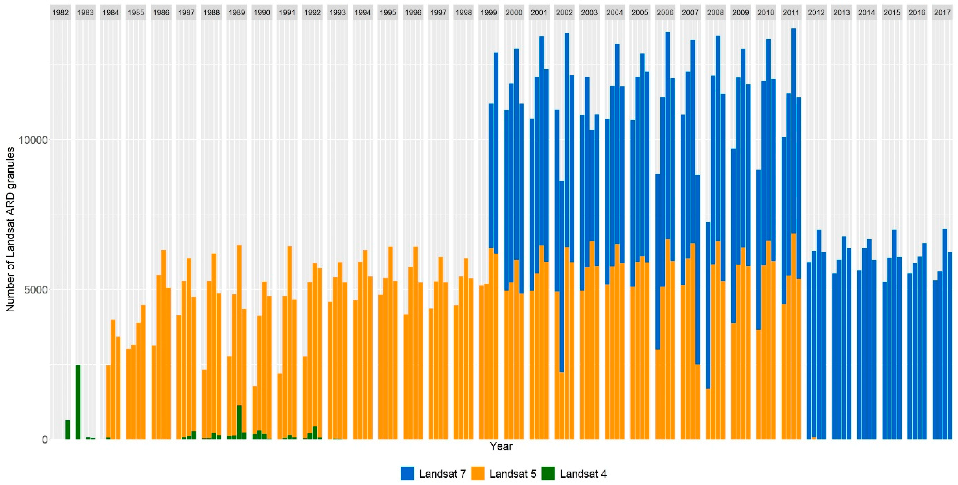
4.1. Sensor Summary Information
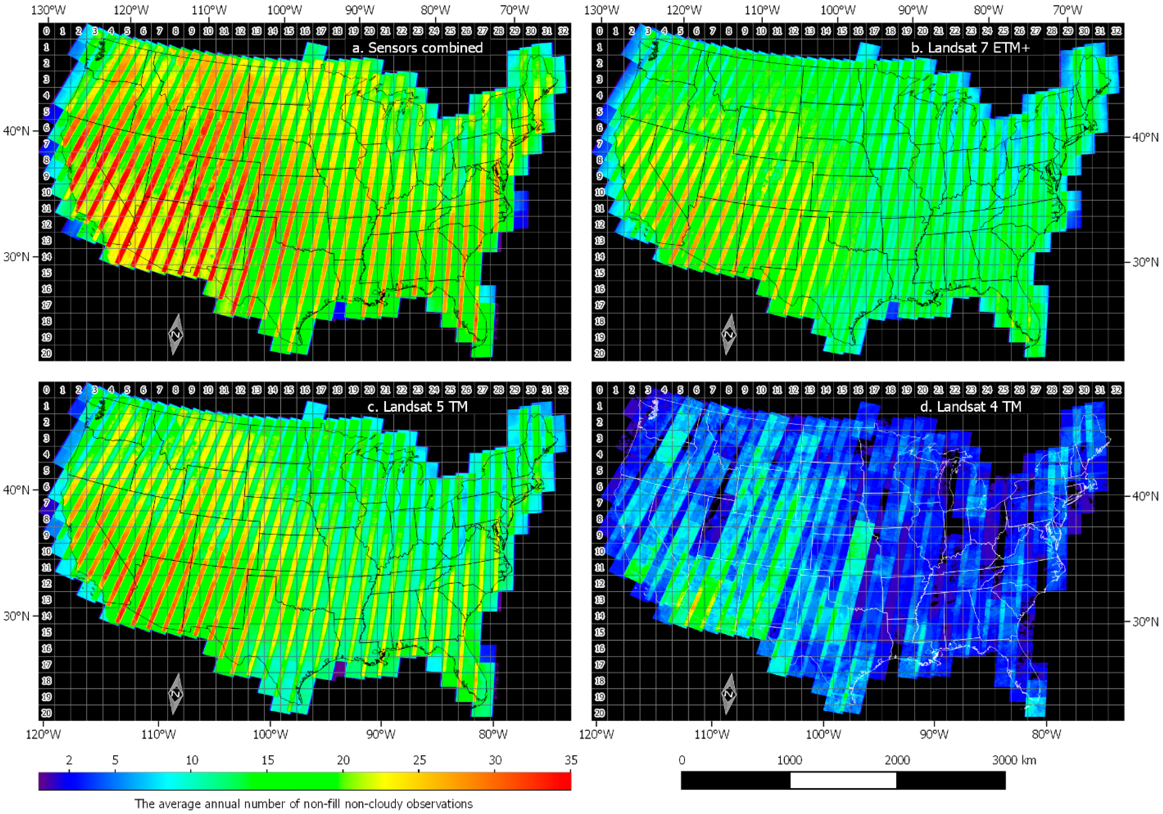
4.2. Pixel-Level Summary Information
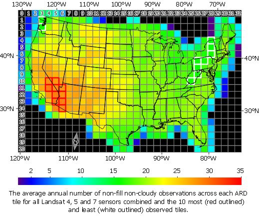
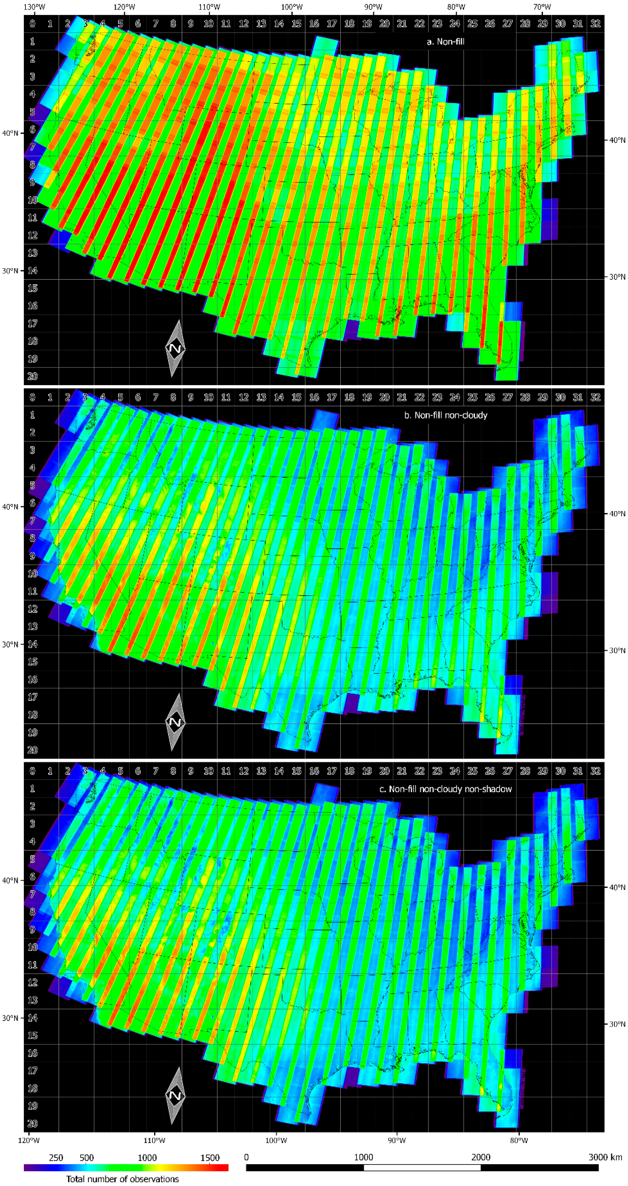
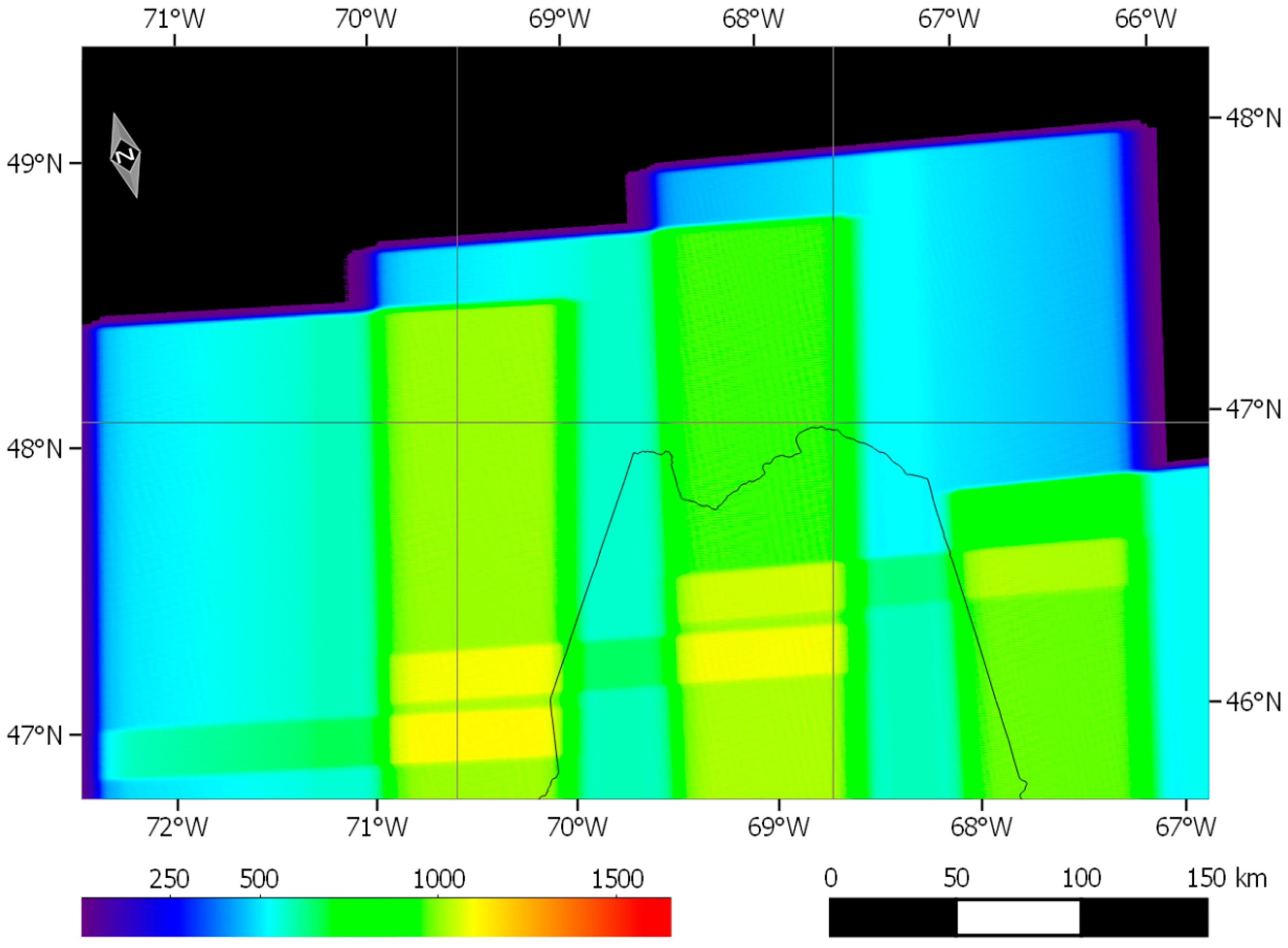
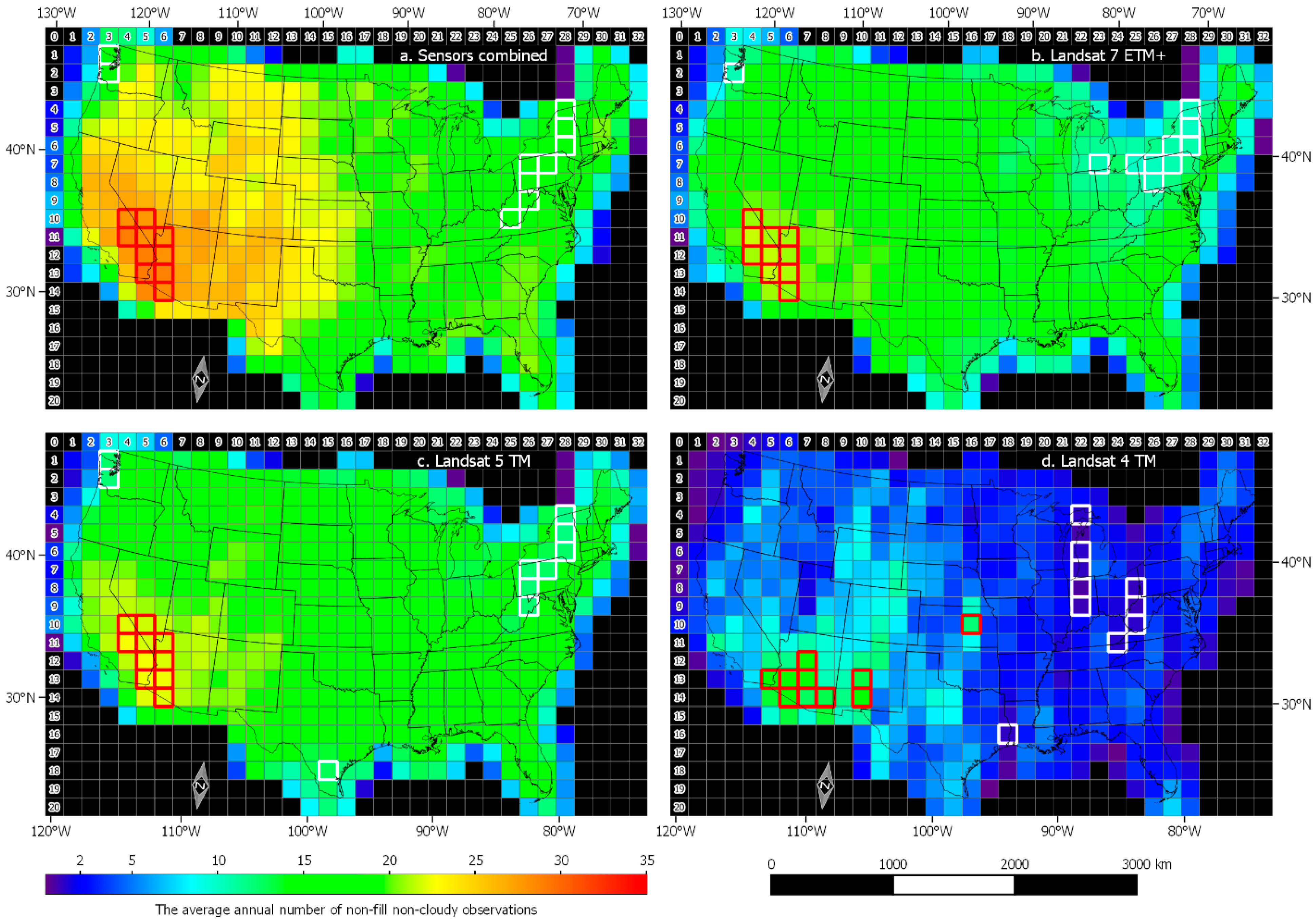
4.3. ARD Tile-Level Summary Information
5. Discussion
6. Conclusions
Author Contributions
Funding
Acknowledgments
Conflicts of Interest
References
- Wulder, M.A.; Loveland, T.R.; Roy, D.P.; Crawford, C.; Masek, J.G.; Woodcock, C.E.; Allen, R.G.; Anderson, M.C.; Belward, A.S.; Cohen, W.B.; et al. Current status of Landsat program, science, and applications. Remote Sens. Environ. 2019. In Press. [Google Scholar]
- Dwyer, J.L.; Roy, D.P.; Sauer, B.; Jenkerson, C.B.; Zhang, H.K.; Lymburner, L. Analysis Ready Data: Enabling analysis of the Landsat archive. Remote Sens. 2018, 10, 1363. [Google Scholar]
- U.S. Landsat Analysis Ready Data. Available online: https://landsat.usgs.gov/ard (accessed on 14 December 2018).
- Kovalskyy, V.; Roy, D.P. The global availability of Landsat 5 TM and Landsat 7 ETM+ land surface observations and implications for global 30m Landsat data product generation. Remote Sens. Environ. 2013, 130, 280–293. [Google Scholar] [CrossRef]
- Wulder, M.A.; White, J.C.; Loveland, T.R.; Woodcock, C.E.; Belward, A.S.; Cohen, W.B.; Fosnight, E.A.; Shaw, J.; Masek, J.G.; Roy, D.P. The global Landsat archive: Status, consolidation, and direction. Remote Sens. Environ. 2016, 185, 271–283. [Google Scholar] [CrossRef]
- Goward, S.; Williams, D.; Arvidson, T.; Rocchio, L.; Irons, J.R.; Russell, C.; Johnston, S. Landsat’s Enduring Legacy: Pioneering Global Land Observations from Space; American Society for Photogrammetry and Remote Sensing: Bethesda, MD, USA, 2017; p. 586. [Google Scholar]
- Asner, G.P. Cloud cover in Landsat observations of the Brazilian Amazon. Int. J. Remote Sens. 2001, 22, 3855–3862. [Google Scholar] [CrossRef]
- Ju, J.; Roy, D.P. The Availability of Cloud-free Landsat ETM+ data over the Conterminous United States and Globally. Remote Sens. Environ. 2008, 112, 1196–1211. [Google Scholar] [CrossRef]
- Tolnai, M.; Nagy, J.G.; Bakó, G. Spatiotemporal distribution of Landsat imagery of Europe using cloud cover-weighted metadata. J. Maps 2016, 12, 1084–1088. [Google Scholar] [CrossRef]
- Whitcraft, A.K.; Becker-Reshef, I.; Killough, B.D.; Justice, C.O. Meeting earth observation requirements for global agricultural monitoring: An evaluation of the revisit capabilities of current and planned moderate resolution optical earth observing missions. Remote Sens. 2015, 7, 1482–1503. [Google Scholar] [CrossRef]
- Li, J.; Roy, D.P. A global analysis of Sentinel-2A, Sentinel-2B and Landsat-8 data revisit intervals and implications for terrestrial monitoring. Remote Sens. 2017, 9, 902. [Google Scholar]
- Kovalskyy, V.; Roy, D.P. A one year Landsat 8 conterminous United States study of cirrus and non-cirrus clouds. Remote Sens. 2015, 7, 564–578. [Google Scholar] [CrossRef]
- Goward, S.; Arvidson, T.; Williams, D.; Faundeen, J.; Irons, J.; Franks, S. Historical record of Landsat global coverage. Photogramm. Eng. Remote Sens. 2006, 72, 1155–1169. [Google Scholar] [CrossRef]
- Arvidson, T.; Goward, S.N.; Gasch, J.; Williams, D. Landsat-7 long-term acquisition plan: Development and validation. Photogramm. Eng. Remote Sens. 2006, 72, 1137–1146. [Google Scholar] [CrossRef]
- Teillet, P.M.; Barker, J.L.; Markham, B.L.; Irish, R.R.; Fedosejevs, G.; Storey, J.C. Radiometric cross-calibration of the Landsat-7 ETM+ and Landsat-5 TM sensors based on tandem data sets. Remote Sens. Environ. 2001, 78, 39–54. [Google Scholar] [CrossRef]
- Food and Agriculture Organization of the United Nations, Global Administrative Unit Layers. Available online: http://www.fao.org/geonetwork/srv/en/main.home (accessed on 14 December 2018).
- Krimmel, R.M.; Key, C.H.; Fagre, D.B.; Menicke, R.K. Glaciers of the conterminous United States—Glaciers of the western United States. In Satellite Images of Glaciers of the World; Professional Paper 1386–J–2; Williams, R.S., Ferrigno, J.G., Eds.; USGS, US Government Printing: Reston, VA, USA, 2002; pp. 329–381. [Google Scholar]
- Pekel, J.-F.; Cottam, A.; Gorelick, N.; Belward, A.S. High-resolution mapping of global surface water and its long-term changes. Nature 2016, 540, 418–422. [Google Scholar] [CrossRef] [PubMed]
- Egorov, A.V.; Hansen, M.C.; Roy, D.P.; Kommareddy, A.; Potapov, P.V. Image interpretation-guided supervised classification using nested segmentation. Remote Sens. Environ. 2015, 165, 135–147. [Google Scholar] [CrossRef]
- Martinec, J.; Rango, A. Areal distribution of snow water equivalent evaluated by snow cover monitoring. Water Resour. Res. 1981, 17, 1480–1488. [Google Scholar] [CrossRef]
- Olmanson, L.G.; Bauer, M.E.; Brezonik, P.L. A 20-year Landsat water clarity census of Minnesota’s 10,000 lakes. Remote Sens. Environ. 2008, 112, 4086–4097. [Google Scholar] [CrossRef]
- Roy, D.P.; Wulder, M.A.; Loveland, T.R.; Woodcock, C.E.; Allen, R.G.; Anderson, M.C.; Helder, D.; Irons, J.R.; Johnson, D.M.; Kennedy, R.; et al. Landsat-8: Science and product vision for terrestrial global change research. Remote Sens. Environ. 2014, 145, 154–172. [Google Scholar] [CrossRef]
- Egorov, A.V.; Roy, D.P.; Zhang, H.K.; Hansen, M.C.; Kommareddy, A. Demonstration of percent tree cover classification using Landsat analysis ready data (ARD) and sensitivity analysis with respect to Landsat ARD processing level. Remote Sens. 2018, 10, 209. [Google Scholar] [CrossRef]
- Lee, D.S.; Storey, J.C.; Choate, M.J.; Hayes, R. Four years of Landsat-7 on-orbit geometric calibration and performance. IEEE Trans. Geosci. Remote Sens. 2004, 42, 2786–2795. [Google Scholar] [CrossRef]
- Roy, D.P.; Ju, J.; Kline, K.; Scaramuzza, P.L.; Kovalskyy, V.; Hansen, M.C.; Loveland, T.R.; Vermote, E.F.; Zhang, C. Web-enabled Landsat Data (WELD): Landsat ETM+ Composited Mosaics of the Conterminous United States. Remote Sens. Environ. 2010, 114, 35–49. [Google Scholar] [CrossRef]
- Markham, B.L.; Storey, J.C.; Williams, D.L.; Irons, J.R. Landsat sensor performance: History and current status. IEEE Trans. Geosci. Remote Sens. 2004, 42, 2691–2694. [Google Scholar] [CrossRef]
- Zhang, H.K.; Roy, D.P. Landsat 5 Thematic Mapper reflectance and NDVI 27-year time series inconsistencies due to satellite orbit change. Remote Sens. Environ. 2016, 186, 217–233. [Google Scholar] [CrossRef]
- Qiu, S.; Lin, Y.; Shang, R.; Zhang, J.; Ma, L.; Zhu, Z. Making Landsat Time Series Consistent: Evaluating and Improving Landsat Analysis Ready Data. Remote Sens. 2019, 11, 51. [Google Scholar] [CrossRef]
- Roy, D.P.; Zhang, H.K.; Ju, J.; Gomez-Dans, J.L.; Lewis, P.E.; Schaaf, C.B.; Sun, Q.; Li, J.; Huang, H.; Kovalskyy, V. A general method to normalize Landsat reflectance data to nadir BRDF adjusted reflectance. Remote Sens. Environ. 2016, 176, 255–271. [Google Scholar] [CrossRef]
- Ju, J.; Masek, J.G. The vegetation greenness trend in Canada and US Alaska from 1984–2012 Landsat data. Remote Sens. Environ. 2016, 176, 1–16. [Google Scholar] [CrossRef]
- Hermance, J.F. Stabilizing high-order, non-classical harmonic analysis of NDVI data for average annual models by damping model roughness. Int. J. Remote Sens. 2007, 28, 2801–2819. [Google Scholar] [CrossRef]
- Brooks, E.B.; Thomas, V.A.; Wynne, R.H.; Coulston, J.W. Fitting the multitemporal curve: A Fourier series approach to the missing data problem in remote sensing analysis. IEEE Trans. Geosci. Remote Sens. 2012, 50, 3340–3353. [Google Scholar] [CrossRef]
- Roy, D.P.; Yan, L. Robust Landsat-based crop time series modelling. Remote Sens. Environ. 2018. [Google Scholar] [CrossRef]
- Lu, D.; Mausel, P.; Brondizio, E.; Moran, E. Change detection techniques. Int. J. Remote Sens. 2004, 25, 2365–2401. [Google Scholar] [CrossRef]
- Zhu, Z. Change detection using landsat time series: A review of frequencies, preprocessing, algorithms, and applications. ISPRS J. Photogramm. Remote Sens. 2017, 130, 370–384. [Google Scholar] [CrossRef]
- Maisongrande, P.; Duchemin, B.; Dedieu, G. VEGETATION/SPOT: An operational mission for the Earth monitoring; presentation of new standard products. Int. J. Remote Sens. 2004, 25, 9–14. [Google Scholar] [CrossRef]
- Roy, D.P.; Lewis, P.; Schaaf, C.; Devadiga, S.; Boschetti, L. The global impact of clouds on the production of MODIS bidirectional reflectance model-based composites for terrestrial monitoring. IEEE Geosci. Remote Sens. Lett. 2006, 3, 452–456. [Google Scholar] [CrossRef]
- Griffiths, P.; van der Linden, S.; Kuemmerle, T.; Hostert, P. A Pixel-Based Landsat Compositing Algorithm for Large Area Land Cover Mapping. IEEE J. Sel. Topics Appl. Earth Observ. Remote Sens. 2013, 6, 2088–2101. [Google Scholar] [CrossRef]
- Helder, D.; Markham, B.; Morfitt, R.; Storey, J.; Barsi, J.; Gascon, F.; Clerc, S.; LaFrance, B.; Masek, J.; Roy, D.P.; et al. Observations and recommendations for the calibration of Landsat 8 OLI and Sentinel 2 MSI for improved data interoperability. Remote Sens. 2018, 10, 1340. [Google Scholar] [CrossRef]
- Foga, S.; Scaramuzza, P.L.; Guo, S.; Zhu, Z.; Dilley, R.D.; Beckmann, T.; Schmidt, G.L.; Dwyer, J.L.; Joseph Hughes, M.; Laue, B. Cloud detection algorithm comparison and validation for operational Landsat data products. Remote Sens. Environ. 2017, 194, 379–390. [Google Scholar] [CrossRef]
- Yan, L.; Roy, D.P. Large-Area Gap Filling of Landsat Reflectance Time Series by Spectral-Angle-Mapper Based Spatio-Temporal Similarity (SAMSTS). Remote Sens. 2018, 10, 609. [Google Scholar] [CrossRef]
- Brooks, E.; Wynne, R.; Thomas, V. Using Window Regression to Gap-Fill Landsat ETM+ Post SLC-Off Data. Remote Sens. 2018, 10, 1502. [Google Scholar] [CrossRef]
- Wolfe, R.; Nishihama, M.; Fleig, A.; Kuyper, J.; Roy, D.; Storey, J.; Patt, F. Achieving sub-pixel geolocation accuracy in support of MODIS land science. Remote Sens. Environ. 2002, 83, 31–49. [Google Scholar] [CrossRef]
- Yan, L.; Roy, D.P.; Li, Z.; Zhang, H.K.; Huang, H. Sentinel-2A multi-temporal misregistration characterization and an orbit-based sub-pixel registration methodology. Remote Sens. Environ. 2018, 215, 495–506. [Google Scholar] [CrossRef]


| Sensor | First CONUS ARD Granule Acquisition Date | Last CONUS ARD Granule Acquisition Date | Sensor Lifetime days|years | Number of Sensing days|years |
|---|---|---|---|---|
| Landsat 4 | 1982/11/11 | 1993/07/16 | 3,900|10.685 | 387|1.060 |
| Landsat 5 | 1984/03/16 | 2012/05/05 | 10,277|28.156 | 9,575|26.233 |
| Landsat 7 | 1999/06/30 | 2017/12/31 | 6,759|18.518 | 6,634|18.175 |
| Landsat 4, 5 and 7 | 1982/11/11 | 2017/12/31 | 12,834|35.162 | 12,191|33.400 |
| Landsat 4,5,7 | Landsat 7 | Landsat 5 | Landsat 4 | ||||
|---|---|---|---|---|---|---|---|
| Tile | Tile | Tile | Tile | ||||
| h05v13 | 30.067 | h04v11 | 21.718 | h04v11 | 22.828 | h06v13 | 16.794 |
| h04v11 | 29.974 | h05v13 | 21.621 | h05v13 | 22.727 | h06v14 | 16.419 |
| h05v12 | 29.876 | h05v12 | 21.522 | h05v12 | 22.669 | h07v13 | 14.637 |
| h06v13 | 29.740 | h06v13 | 21.001 | h06v13 | 22.635 | h07v12 | 14.413 |
| h06v14 | 29.217 | h04v12 | 20.937 | h04v10 | 22.303 | h05v13 | 14.211 |
| h04v10 | 29.024 | h05v11 | 20.900 | h06v14 | 22.280 | h10v14 | 12.974 |
| h05v11 | 28.982 | h06v11 | 20.761 | h06v12 | 22.064 | h10v13 | 12.292 |
| h06v12 | 28.941 | h04v10 | 20.746 | h05v11 | 22.035 | h08v14 | 12.128 |
| h06v11 | 28.749 | h06v12 | 20.695 | h06v11 | 21.855 | h07v14 | 11.790 |
| h05v10 | 28.512 | h06v14 | 20.576 | h05v10 | 21.804 | h16v10 | 11.441 |
| Landsat 4,5,7 | Landsat 7 | Landsat 5 | Landsat 4 | ||||
|---|---|---|---|---|---|---|---|
| Tile | Tile | Tile | Tile | ||||
| h28v04 | 14.231 | h25v07 | 9.728 | h28v04 | 11.077 | h22v08 | 0.526 |
| h28v05 | 14.273 | h28v05 | 9.792 | h28v05 | 11.177 | h22v09 | 0.789 |
| h03v02 | 14.546 | h28v04 | 9.905 | h03v02 | 11.453 | h25v09 | 0.840 |
| h26v07 | 14.582 | h26v07 | 9.916 | h26v09 | 11.535 | h25v08 | 0.859 |
| h26v08 | 14.589 | h26v08 | 10.031 | h26v08 | 11.547 | h18v16 | 0.995 |
| h26v09 | 14.864 | h03v02 | 10.069 | h26v07 | 11.587 | h22v07 | 1.019 |
| h27v07 | 14.905 | h23v07 | 10.105 | h03v01 | 11.652 | h22v04 | 1.056 |
| h03v01 | 14.946 | h27v07 | 10.217 | h28v06 | 11.726 | h25v10 | 1.076 |
| h28v06 | 14.957 | h28v06 | 10.262 | h27v07 | 11.789 | h24v11 | 1.087 |
| h25v10 | 15.144 | h27v06 | 10.293 | h15v18 | 11.983 | h22v06 | 1.104 |
© 2019 by the authors. Licensee MDPI, Basel, Switzerland. This article is an open access article distributed under the terms and conditions of the Creative Commons Attribution (CC BY) license (http://creativecommons.org/licenses/by/4.0/).
Share and Cite
Egorov, A.V.; Roy, D.P.; Zhang, H.K.; Li, Z.; Yan, L.; Huang, H. Landsat 4, 5 and 7 (1982 to 2017) Analysis Ready Data (ARD) Observation Coverage over the Conterminous United States and Implications for Terrestrial Monitoring. Remote Sens. 2019, 11, 447. https://doi.org/10.3390/rs11040447
Egorov AV, Roy DP, Zhang HK, Li Z, Yan L, Huang H. Landsat 4, 5 and 7 (1982 to 2017) Analysis Ready Data (ARD) Observation Coverage over the Conterminous United States and Implications for Terrestrial Monitoring. Remote Sensing. 2019; 11(4):447. https://doi.org/10.3390/rs11040447
Chicago/Turabian StyleEgorov, Alexey V., David P. Roy, Hankui K. Zhang, Zhongbin Li, Lin Yan, and Haiyan Huang. 2019. "Landsat 4, 5 and 7 (1982 to 2017) Analysis Ready Data (ARD) Observation Coverage over the Conterminous United States and Implications for Terrestrial Monitoring" Remote Sensing 11, no. 4: 447. https://doi.org/10.3390/rs11040447
APA StyleEgorov, A. V., Roy, D. P., Zhang, H. K., Li, Z., Yan, L., & Huang, H. (2019). Landsat 4, 5 and 7 (1982 to 2017) Analysis Ready Data (ARD) Observation Coverage over the Conterminous United States and Implications for Terrestrial Monitoring. Remote Sensing, 11(4), 447. https://doi.org/10.3390/rs11040447