Improving Remote Sensing Image Super-Resolution Mapping Based on the Spatial Attraction Model by Utilizing the Pansharpening Technique




Abstract
1. Introduction
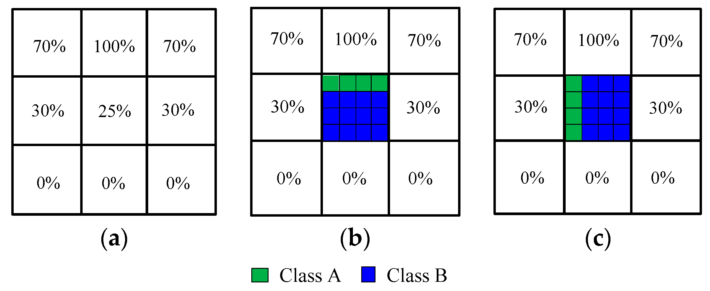
2. Theory of Spatial Correlation
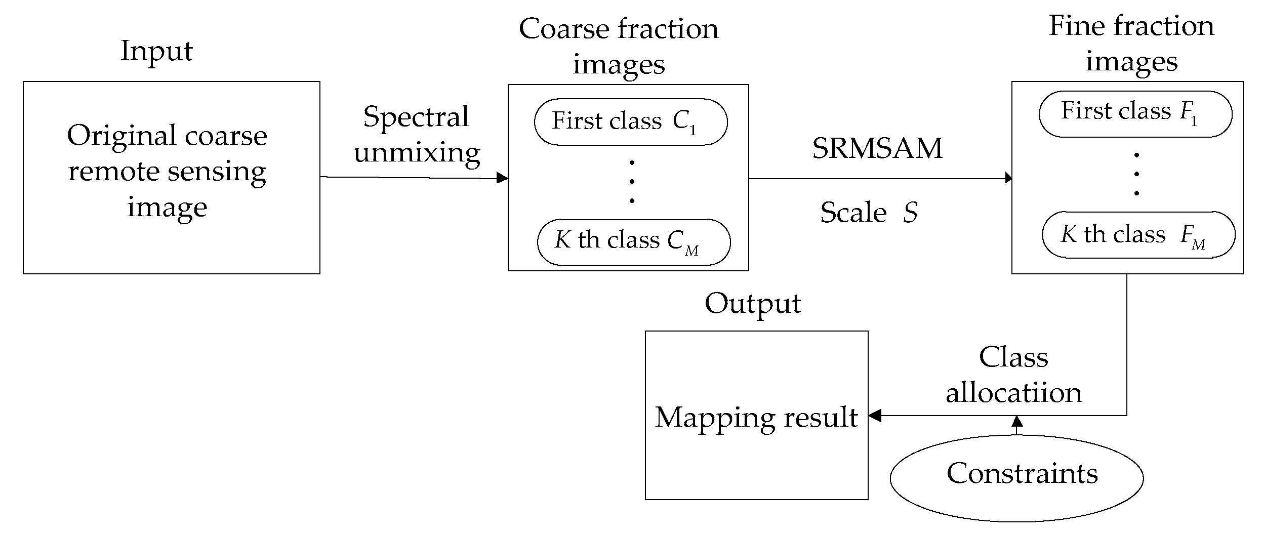
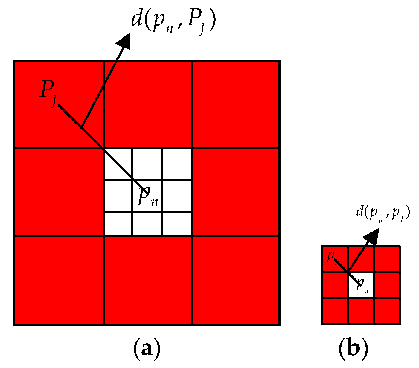
3. SRMSAM
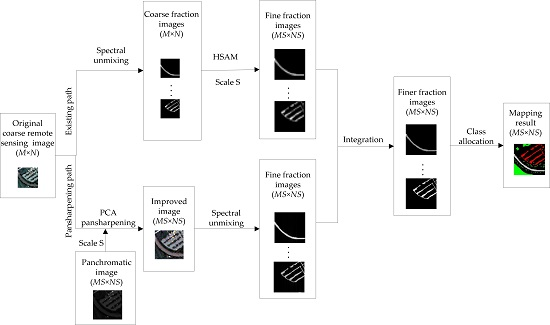
4. Proposed Method
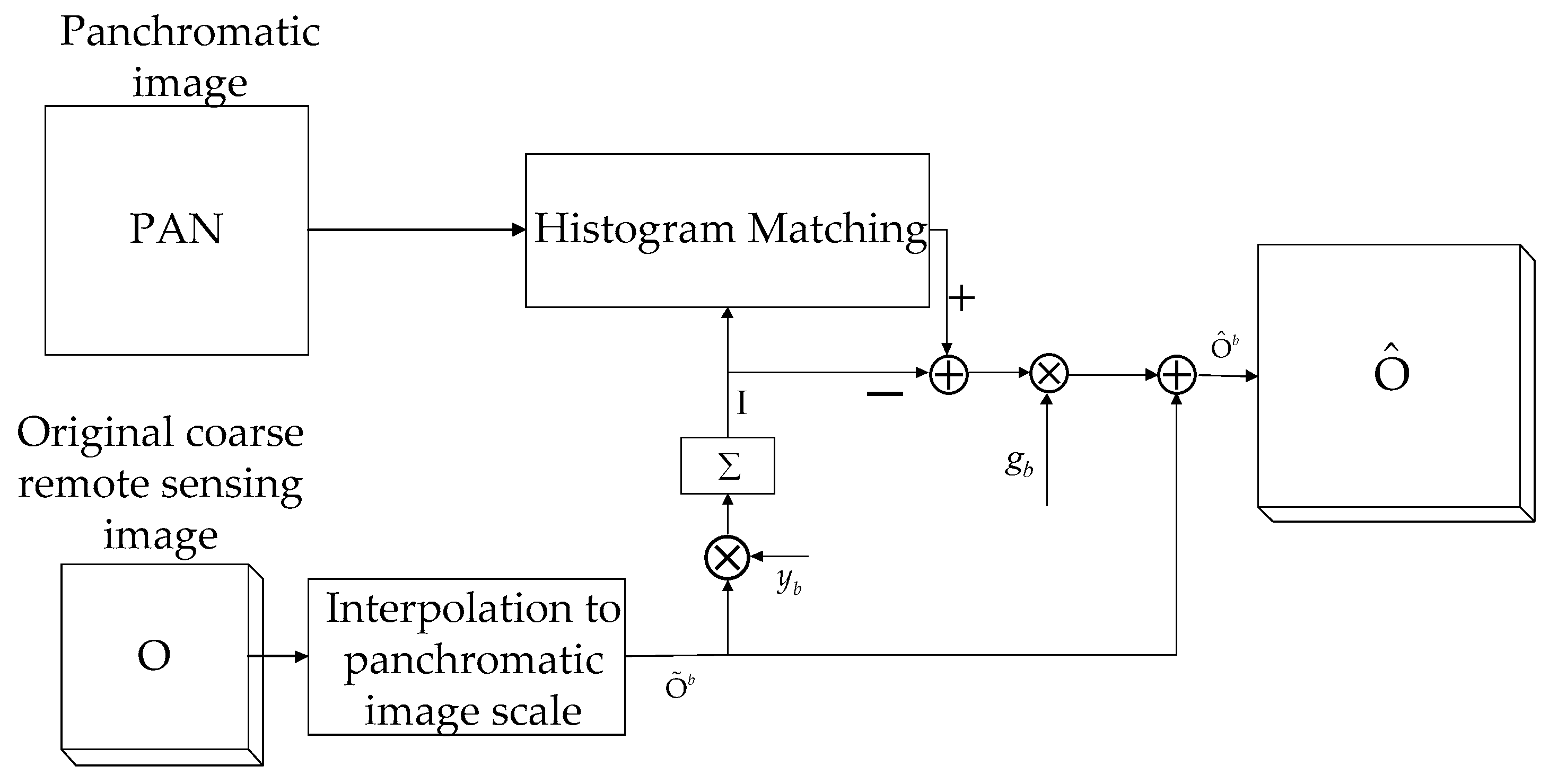
4.1. Pansharpening Path
4.2. Implementation of SRMSAM-PAN
5. Experiments and Analysis
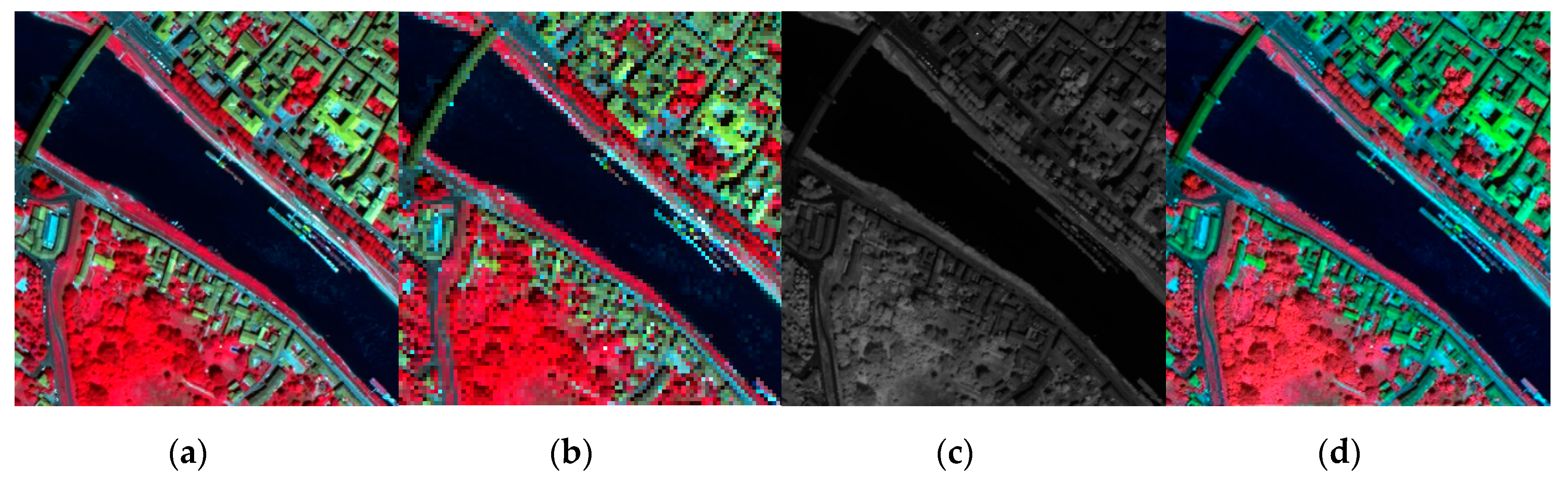
5.1. Experiment 1
5.2. Experiment 2
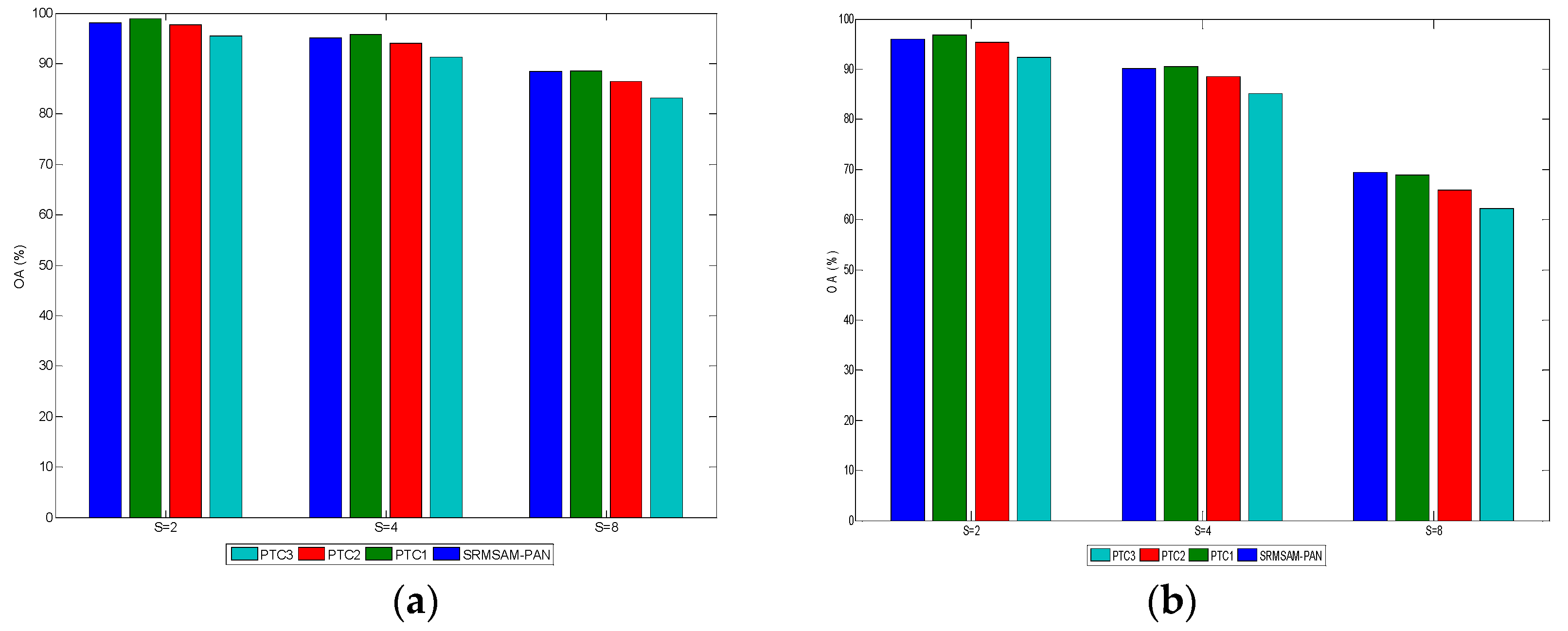
5.3. Experiment 3
5.4. Discussion
6. Conclusions
Author Contributions
Funding
Acknowledgments
Conflicts of Interest
References
- Fisher, P. The pixel: A snare and a delusion. Int. J. Remote Sens. 1997, 18, 679–685. [Google Scholar] [CrossRef] [Scilit]
- Wang, L.; Liu, D.; Wang, Q. Geometric method of fully constrained least squares linear spectral mixture analysis. IEEE Trans. Geosci. Remote Sens. 2013, 51, 3558–3566. [Google Scholar] [CrossRef]
- Atkinson, P.M. Mapping sub-pixel boundaries from remotely sensed images. In Innovations in GIS; Taylor & Francis: New York, NY, USA, 1997; pp. 166–180. [Google Scholar]
- Ma, A.; Zhong, Y.; He, D.; Zhang, L. Multi-objective subpixel land-cover mapping. IEEE Trans. Geosci. Remote Sens. 2018, 56, 422–435. [Google Scholar] [CrossRef] [Scilit]
- Atkinson, P.M. Sub-pixel target mapping from soft-classified remotely sensed imagery. Photogramm. Eng. Remote Sens. 2005, 71, 839–846. [Google Scholar] [CrossRef] [Scilit]
- Tatem, A.J.; Lewis, H.G.; Atkinson, P.M.; Nixon, M.S. Super-resolution target identification form remotely sensed images using a Hopfield neural network. IEEE Trans. Geosci. Remote Sens. 2011, 39, 781–796. [Google Scholar] [CrossRef] [Scilit]
- Muad, A.M.; Foody, G.M. Impact of land cover patch size on the accuracy of patch area representation in HNN-based super resolution mapping. IEEE J. Sel. Top. Appl. Earth Observ. Remote Sens. 2012, 5, 1418–1427. [Google Scholar] [CrossRef] [Scilit]
- Shao, Y.; Lunetta, R.S. Sub-pixel mapping of tree canopy, impervious surfaces, and cropland in the Laurentian great lakes basin using MODIS time-series data. IEEE J. Sel. Top. Appl. Earth Observ. Remote Sens. 2011, 4, 336–347. [Google Scholar] [CrossRef] [Scilit]
- Nigussie, D.; Zurita-Milla, R.; Clevers, J.G.P.W. Possibilities and limitations of artificial neural networks for subpixel mapping of land cover. Int. J. Remote Sens. 2011, 32, 7203–7226. [Google Scholar] [CrossRef] [Scilit]
- Chen, Y.; Ge, Y.; Heuvelink, G.B.M.; An, R.; Chen, Y. Object-based superresolution land-cover mapping from remotely sensed imagery. IEEE Trans. Geosci. Remote Sens. 2018, 56, 328–340. [Google Scholar] [CrossRef]
- Chen, Y.; Zhou, Y.; Ge, Y.; An, R.; Chen, Y. Enhancing land cover mapping through integration of pixel-based and object-based classifications from remotely sensed imagery. Remote Sens. 2018, 10, 77. [Google Scholar] [CrossRef] [Scilit]
- Jin, H.; Mountrakis, G.; Li, P. A super-resolution mapping method using local indicator variograms. Int. J. Remote Sens. 2012, 33, 7747–7773. [Google Scholar] [CrossRef] [Scilit]
- Wang, Q.; Atkinson, P.M.; Shi, W. Indicator cokriging-based subpixel mapping without prior spatial structure information. IEEE Trans. Geosci. Remote Sens. 2015, 53, 309–323. [Google Scholar] [CrossRef] [Scilit]
- Wang, Q.; Atkinson, P.M. The effect of the point spread function on sub-pixel mapping. Remote Sens. Environ. 2017, 193, 127–137. [Google Scholar] [CrossRef] [Scilit]
- Chen, Y.; Ge, Y.; An, R.; Chen, Y. Super-resolution mapping of impervious surfaces from remotely sensed imagery with points-of-interest. Remote Sens. 2018, 10, 242. [Google Scholar] [CrossRef] [Scilit]
- Wang, P.; Zhang, G.; Kong, Y.; Leung, H. Superresolution mapping based on hybrid interpolation by parallel paths. Remote Sens. Lett. 2019, 10, 149–157. [Google Scholar] [CrossRef] [Scilit]
- Wang, Q.; Shi, W.; Atkinson, P.M. Spatiotemporal subpixel mapping of time-series images. IEEE Trans. Geosci. Remote Sens. 2016, 54, 5397–5411. [Google Scholar] [CrossRef]
- Wang, P.; Wang, L.; Chanussot, J. Soft-then-hard subpixel land cover mapping based on spatial-spectral interpolation. IEEE Geosci. Remote Sens. Lett. 2016, 13, 1851–1854. [Google Scholar] [CrossRef] [Scilit]
- Wang, Q.; Shi, W.; Wang, L. Allocating classes for soft-then-hard sub-pixel mapping algorithms in units of class. IEEE Trans. Geosci. Remote Sens. 2014, 5, 2940–2959. [Google Scholar] [CrossRef]
- Li, F.; Jia, X. Superresolution reconstruction of multispectral data for improved image classification. IEEE Geosci. Remote Sens. Lett. 2009, 5, 798–802. [Google Scholar]
- Wang, L.; Wang, P.; Zhao, C. Producing subpixel resolution thematic map from coarse imagery: MAP algorithm-based super-resolution recovery. IEEE J. Sel. Top. Appl. Earth Observ. Remote Sens. 2016, 9, 2290–2304. [Google Scholar] [CrossRef] [Scilit]
- Wang, P.; Wang, L.; Wu, Y.; Leung, H. Utilizing pansharpening technique to produce sub-pixel resolution thematic map from coarse remote sensing image. Remote Sens. 2018, 10, 884. [Google Scholar] [CrossRef] [Scilit]
- Wang, Q.; Wang, L.; Liu, D. Particle swarm optimization-based sub-pixel mapping for remote-sensing imagery. Int. J. Remote Sens. 2012, 33, 6480–6496. [Google Scholar] [CrossRef] [Scilit]
- Wang, P.; Zhang, G.; Leung, H. Improving super-resolution flood inundation mapping for multispectral remote sensing image by supplying more spectral information. IEEE Geosci. Remote Sens. Lett. 2018. [Google Scholar] [CrossRef] [Scilit]
- Zhang, Y.; Ling, F.; Li, X.; Du, Y. Super-resolution land cover mapping using multiscale self-similarity redundancy. IEEE J. Sel. Top. Appl. Earth Observ. Remote Sens. 2015, 8, 5130–5145. [Google Scholar] [CrossRef] [Scilit]
- Tong, X.; Xu, X.; Plaza, A.; Xie, H.; Pan, H.; Cao, W.; Lv, D. A new genetic method for subpixel mapping using hyperspectral images. IEEE J. Sel. Top. Appl. Earth Observ. Remote Sens. 2016, 9, 4480–4491. [Google Scholar] [CrossRef] [Scilit]
- Wang, Q.; Shi, W.; Atkinson, P.M. Sub-pixel mapping of remote sensing images based on radial basis function interpolation. ISPRS J. Photogramm. 2014, 92, 1–15. [Google Scholar] [CrossRef] [Scilit]
- Xu, X.; Zhong, Y.; Zhang, L.; Zhang, H. Sub-pixel mapping based on a MAP model with multiple shifted hyperspectral imagery. IEEE J. Sel. Top. Appl. Earth Observ. Remote Sens. 2013, 6, 580–593. [Google Scholar] [CrossRef] [Scilit]
- Wang, P.; Wang, L.; Mura, M.D.; Chanussot, J. Using multiple subpixel shifted images with spatial-spectral information in soft-then-hard subpixel mapping. IEEE J. Sel. Top. Appl. Earth Observ. Remote Sens. 2017, 13, 1851–1854. [Google Scholar] [CrossRef] [Scilit]
- Nguyen, M.Q.; Atkinson, P.M.; Lewis, H.G. Superresolution mapping using Hopfield neural network with LIDAR data. IEEE Geosci. Remote Sens. Lett. 2005, 2, 366–370. [Google Scholar] [CrossRef] [Scilit]
- Nguyen, M.Q.; Atkinson, P.M.; Lewis, H.G. Superresolution mapping using a Hopfield neural network with fused images. IEEE Trans. Geosci. Remote Sens. 2006, 44, 736–749. [Google Scholar] [CrossRef] [Scilit]
- Nguyen, M.Q.; Atkinson, P.M.; Lewis, H.G. Super-resolution mapping using Hopfield neural network with panchromatic imagery. Int. J. Remote Sens. 2011, 32, 6149–6176. [Google Scholar] [CrossRef] [Scilit]
- Thornton, M.W.; Atkinson, P.M.; Holland, D.A. A linearised pixel swapping method for mapping rural linear land cover features from fine spatial resolution remotely sensed imagery. Comput. Geosci. 2007, 33, 1261–1272. [Google Scholar] [CrossRef] [Scilit]
- Mertens, K.C.; Basets, B.D.; Verbeke, L.P.C.; De Wulf, R. A sub-pixel mapping algorithm based on sub-pixel/pixel spatial attraction models. Int. J. Remote Sens. 2006, 27, 3293–3310. [Google Scholar] [CrossRef] [Scilit]
- Ling, F.; Li, X.; Du, Y.; Xiao, F. Sub-pixel mapping of remotely sensed imagery with hybrid intra- and inter-pixel dependence. Int. J. Remote Sens. 2013, 34, 341–357. [Google Scholar] [CrossRef] [Scilit]
- Wang, P.; Wang, L. Soft-then-hard super-resolution mapping based on a spatial attraction model with multiscale sub-pixel shifted images. Int. J. Remote Sens. 2017, 38, 4303–4326. [Google Scholar] [CrossRef] [Scilit]
- Vivone, G.; Alparone, L.; Chanussot, J.; Mura, M.D.; Garzelli, A.; Licciardi, G.; Restaino, R.; Wald, L. A critical comparison among pansharpening algorithms. IEEE Trans. Geosci. Remote Sens. 2015, 53, 2565–2585. [Google Scholar] [CrossRef] [Scilit]
- Wang, L.; Liu, D.; Wang, Q. Spectral unmixing model based on least squares support vector machine with unmixing residue constraints. IEEE Geosci. Remote Sens. Lett. 2013, 10, 1592–1596. [Google Scholar] [CrossRef] [Scilit]
- Wang, P.; Zhang, G.; Leung, H. Utilizing parallel networks to produce sub-pixel shifted images with multiscale spatio-spectral information for soft-then-hard sub-pixel mapping. IEEE Access. 2018, 6, 57485–57496. [Google Scholar] [CrossRef] [Scilit]
- Thomas, C.; Ranchin, T.; Wald, L.; Chanussot, J. Synthesis of multispectral images to high spatial resolution: A critical review of fusion methods based on remote sensing physics. IEEE Trans. Geosci. Remote Sens. 2008, 46, 1301–1312. [Google Scholar] [CrossRef] [Scilit]
- Ge, Y.; Chen, Y.; Stein, A.; Li, S.; Hu, J. Enhanced sub-pixel mapping with spatial distribution patterns of geographical objects. IEEE Trans. Geosci. Remote Sens. 2016, 54, 2356–2370. [Google Scholar] [CrossRef] [Scilit]
- Zhang, L.; Zhang, L.; Tao, D.; Huang, X. Tensor discriminative locality alignment for hyperspectral image spectral-spatial feature extraction. IEEE Trans. Geosci. Remote Sens. 2013, 51, 242–256. [Google Scholar] [CrossRef] [Scilit]
- Garzelli, A.; Nencini, F.; Capobianco, L. Optimal MMSE pan sharpening of very high resolution multispectral images. IEEE Trans. Geosci. Remote Sens. 2008, 46, 228–236. [Google Scholar] [CrossRef] [Scilit]

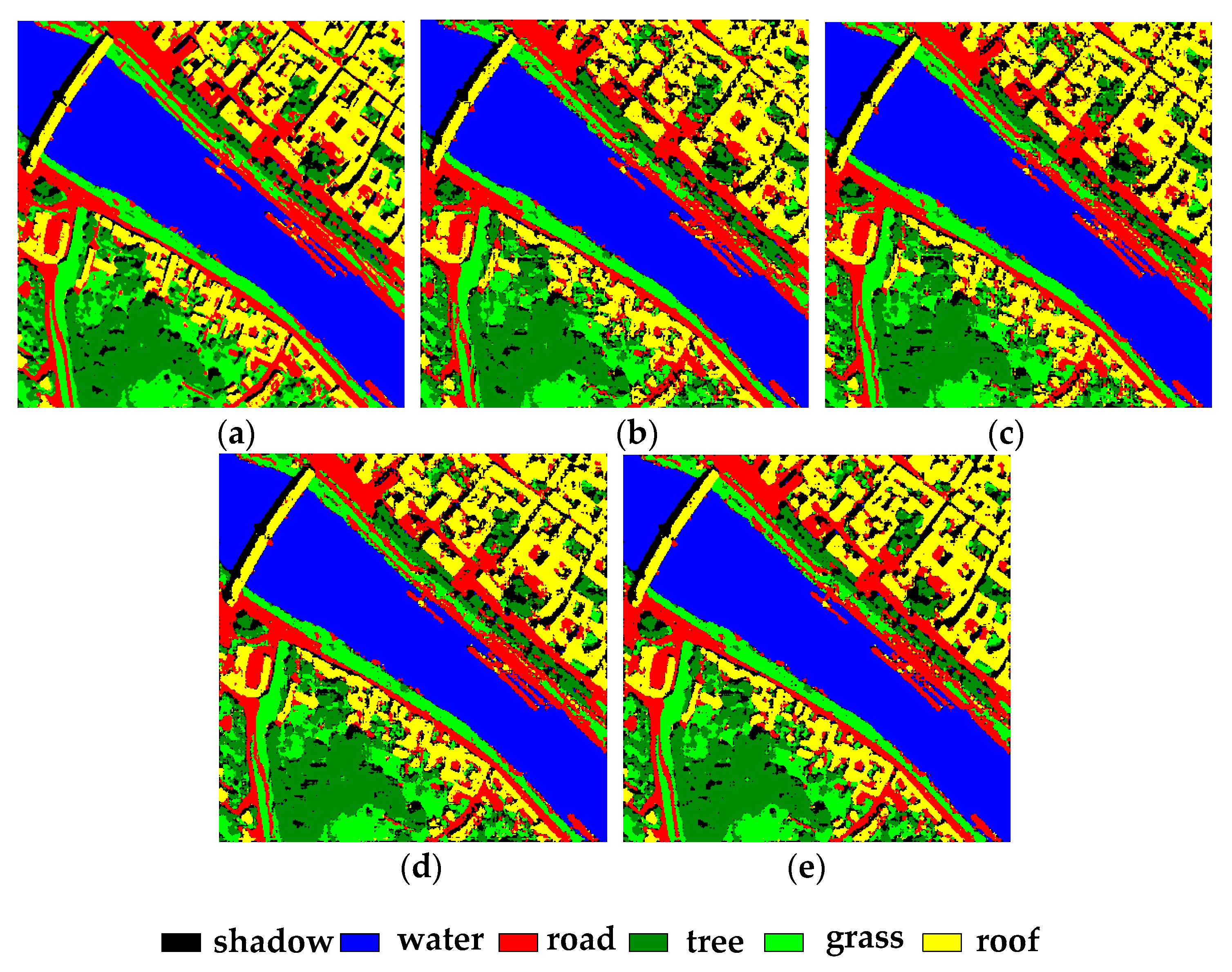
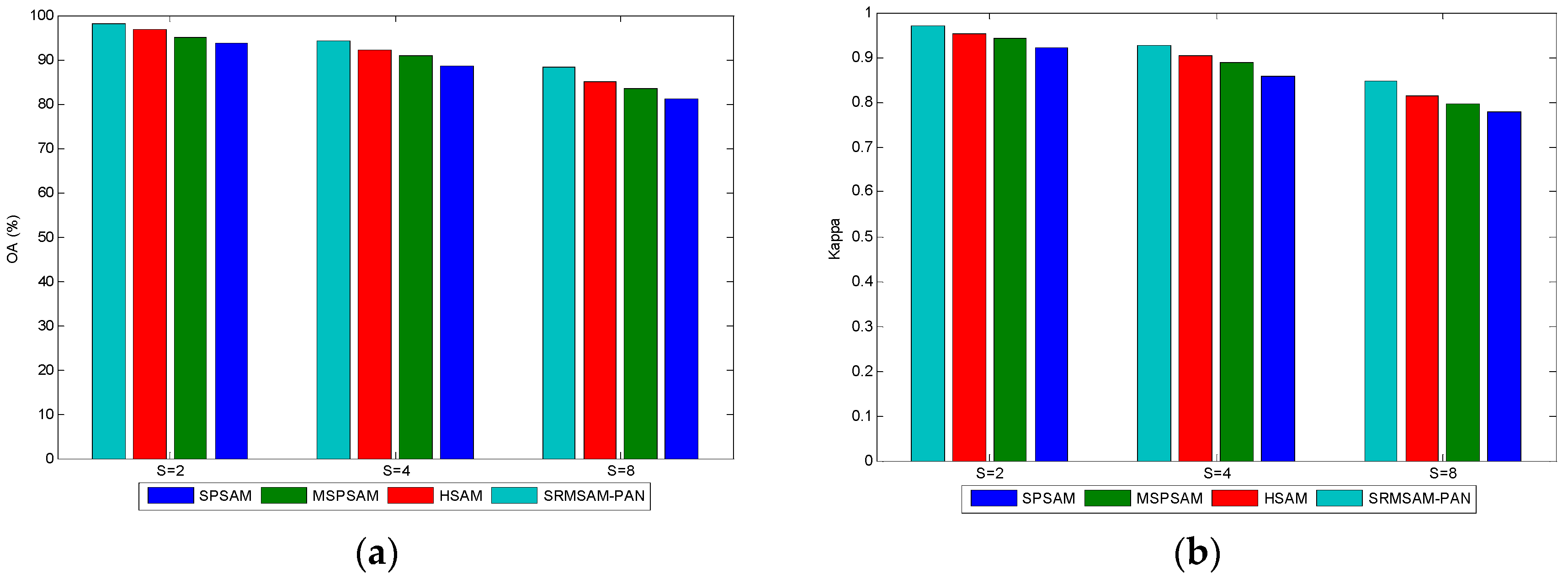
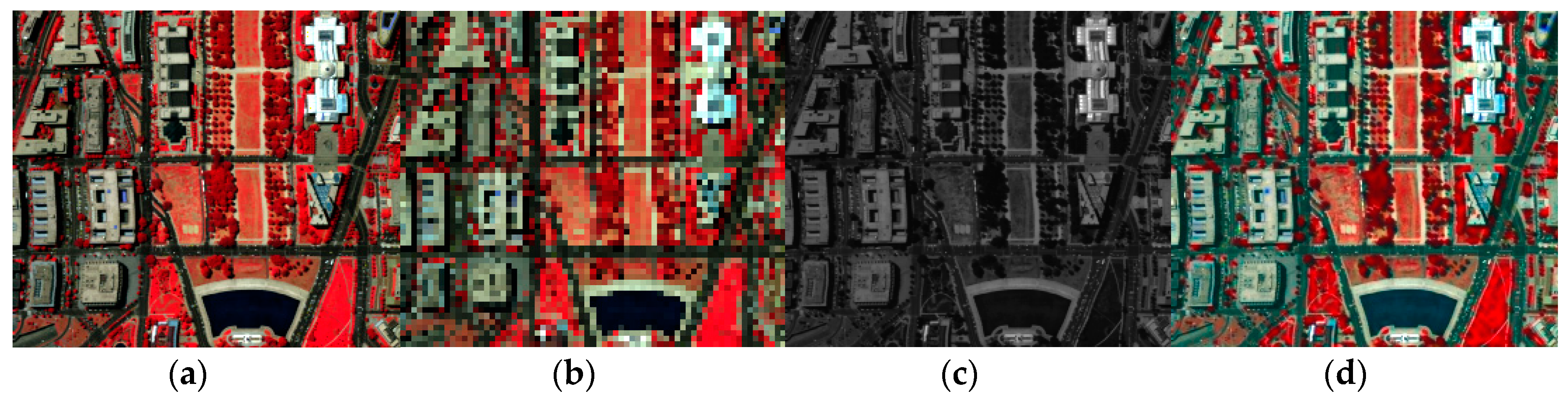
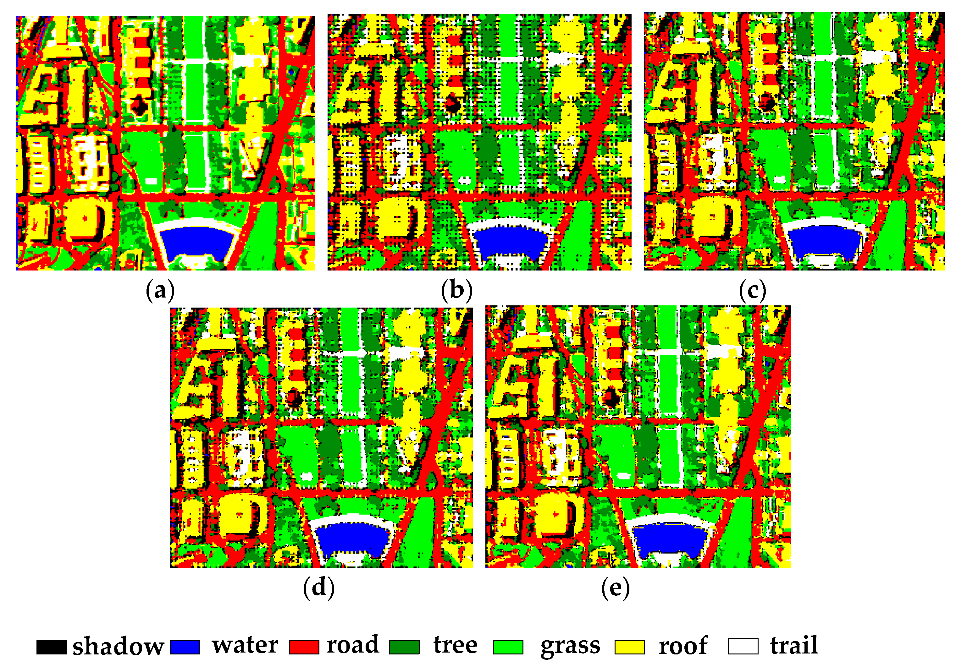
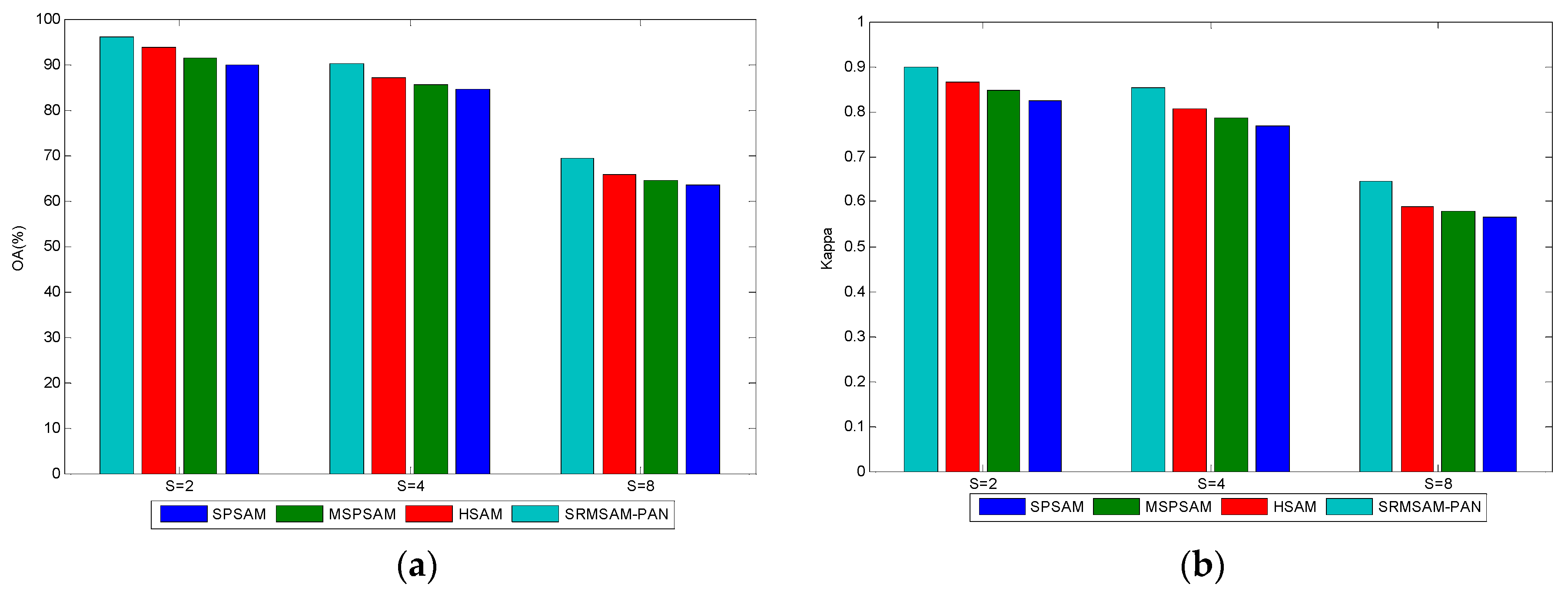
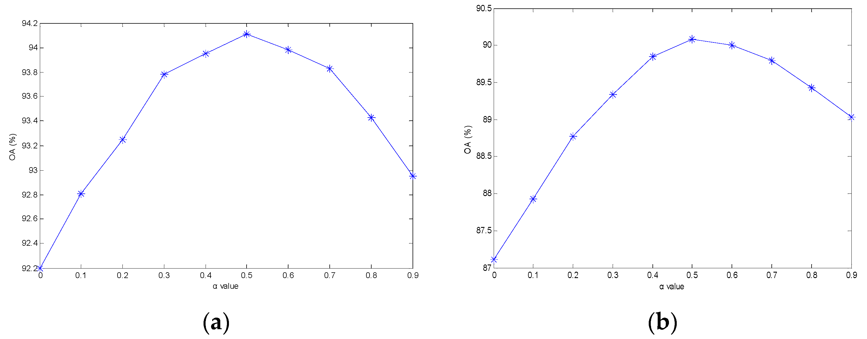

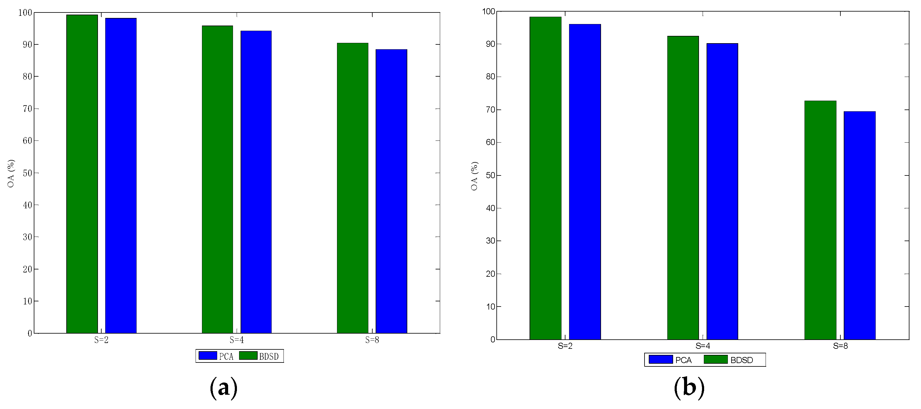

| SPSAM | MSPSAM | HSAM | SRMSAM-PAN | |
|---|---|---|---|---|
| Meadows | 96.37 | 97.10 | 97.73 | 99.13 |
| Asphalt | 95.48 | 97.29 | 97.47 | 99.82 |
| Tress | 45.13 | 55.23 | 56.32 | 72.31 |
| Bricks | 77.18 | 83.37 | 83.60 | 90.30 |
| OA | 85.17 | 88.73 | 89.20 | 93.87 |
| SPSAM | MSPSAM | HSAM | SRMSAM-PAN | |
|---|---|---|---|---|
| Shadow | 52.46 | 62.80 | 65.98 | 74.57 |
| Water | 98.04 | 98.33 | 98.35 | 98.76 |
| Road | 79.38 | 82.97 | 84.03 | 89.74 |
| Tree | 80.95 | 83.47 | 84.52 | 89.00 |
| Grass | 80.51 | 83.94 | 85.66 | 89.41 |
| Roof | 85.89 | 88.63 | 89.87 | 92.49 |
| OA | 88.52 | 90.86 | 92.20 | 95.11 |
© 2019 by the authors. Licensee MDPI, Basel, Switzerland. This article is an open access article distributed under the terms and conditions of the Creative Commons Attribution (CC BY) license (http://creativecommons.org/licenses/by/4.0/).
Share and Cite
Wang, P.; Zhang, G.; Hao, S.; Wang, L. Improving Remote Sensing Image Super-Resolution Mapping Based on the Spatial Attraction Model by Utilizing the Pansharpening Technique. Remote Sens. 2019, 11, 247. https://doi.org/10.3390/rs11030247
Wang P, Zhang G, Hao S, Wang L. Improving Remote Sensing Image Super-Resolution Mapping Based on the Spatial Attraction Model by Utilizing the Pansharpening Technique. Remote Sensing. 2019; 11(3):247. https://doi.org/10.3390/rs11030247
Chicago/Turabian StyleWang, Peng, Gong Zhang, Siyuan Hao, and Liguo Wang. 2019. "Improving Remote Sensing Image Super-Resolution Mapping Based on the Spatial Attraction Model by Utilizing the Pansharpening Technique" Remote Sensing 11, no. 3: 247. https://doi.org/10.3390/rs11030247
APA StyleWang, P., Zhang, G., Hao, S., & Wang, L. (2019). Improving Remote Sensing Image Super-Resolution Mapping Based on the Spatial Attraction Model by Utilizing the Pansharpening Technique. Remote Sensing, 11(3), 247. https://doi.org/10.3390/rs11030247