Application of Ensemble-Based Machine Learning Models to Landslide Susceptibility Mapping




Abstract
1. Introduction
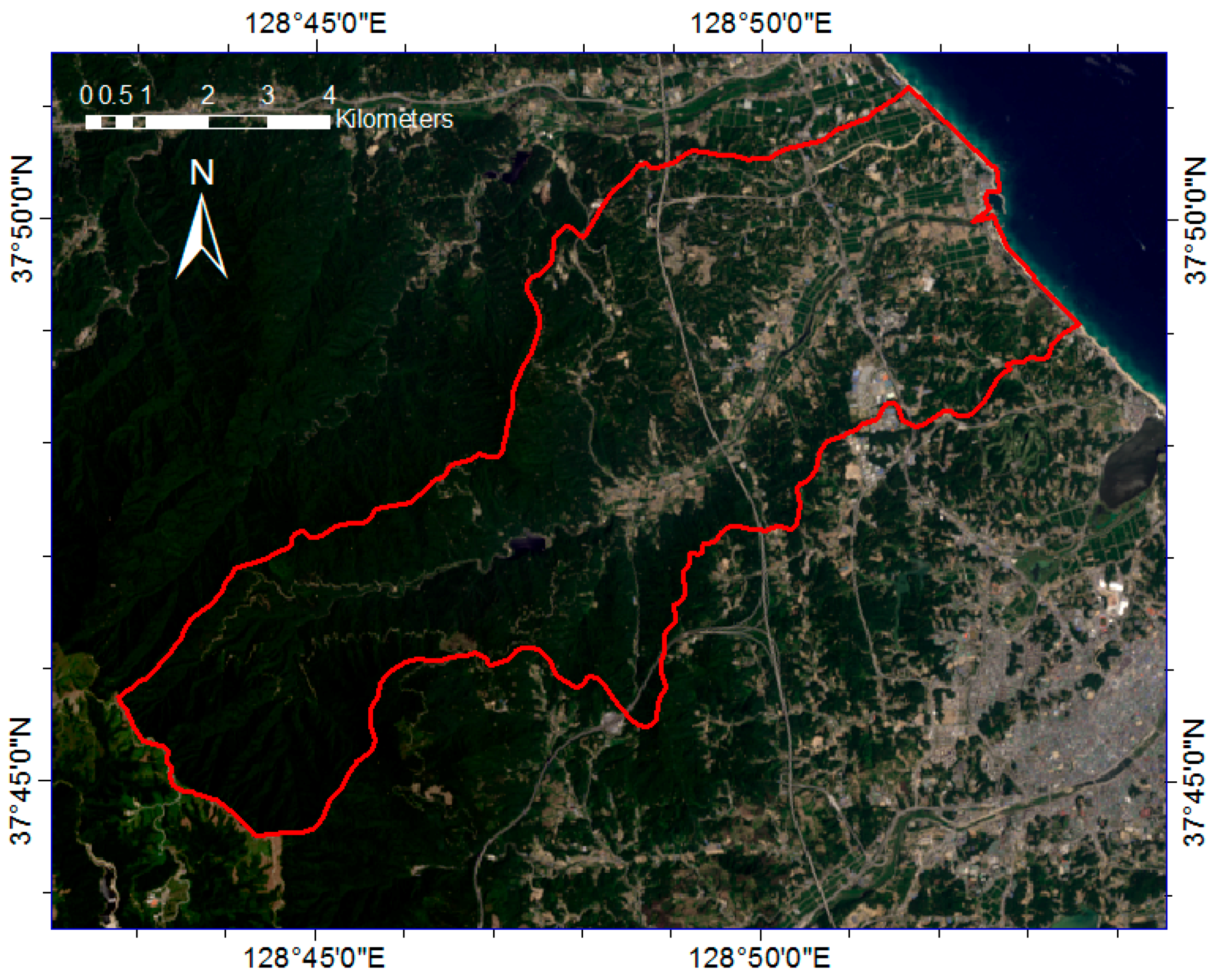
2. Study Area and Materials
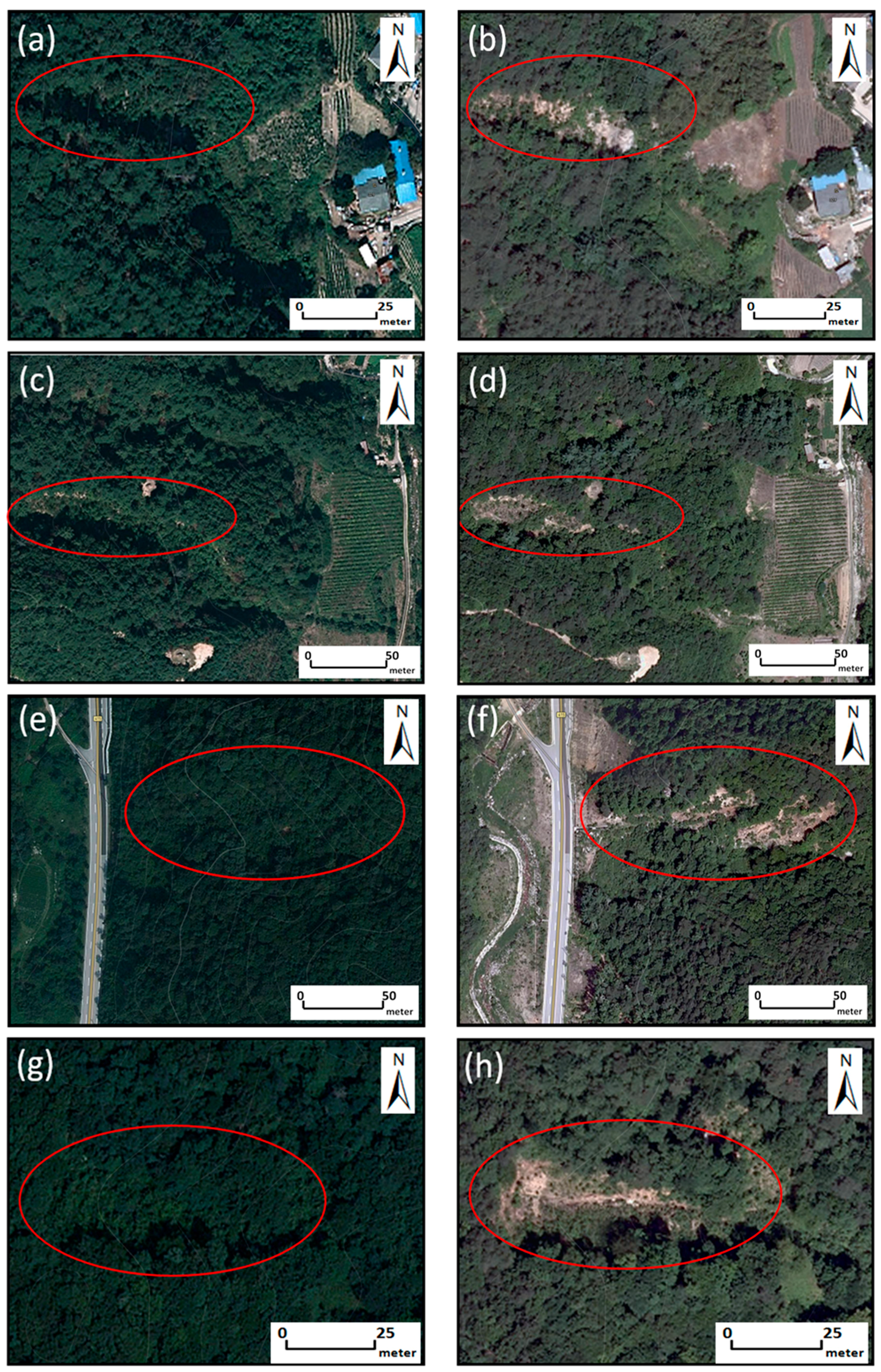
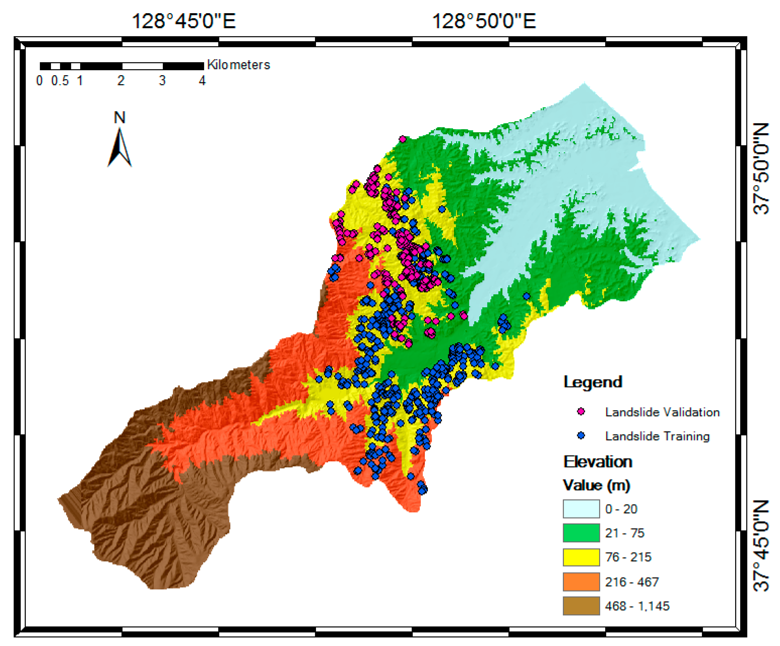
2.1. Landslide Inventory
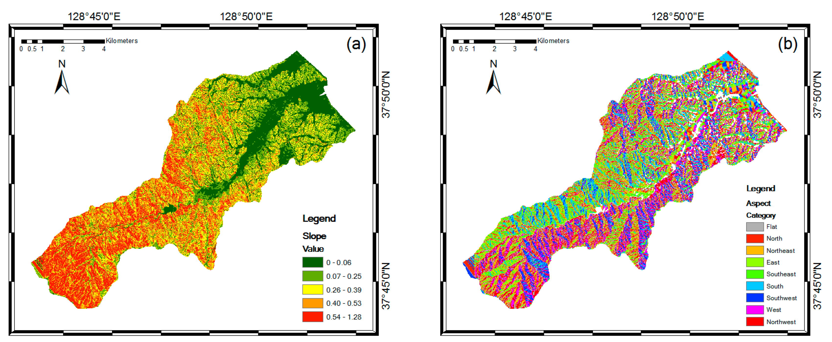
2.2. Landslide Conditioning Factors
3. Methods
3.1. AdaBoost
3.2. LogitBoost
3.3. Multiclass Classifier
3.4. Bagging
4. Results
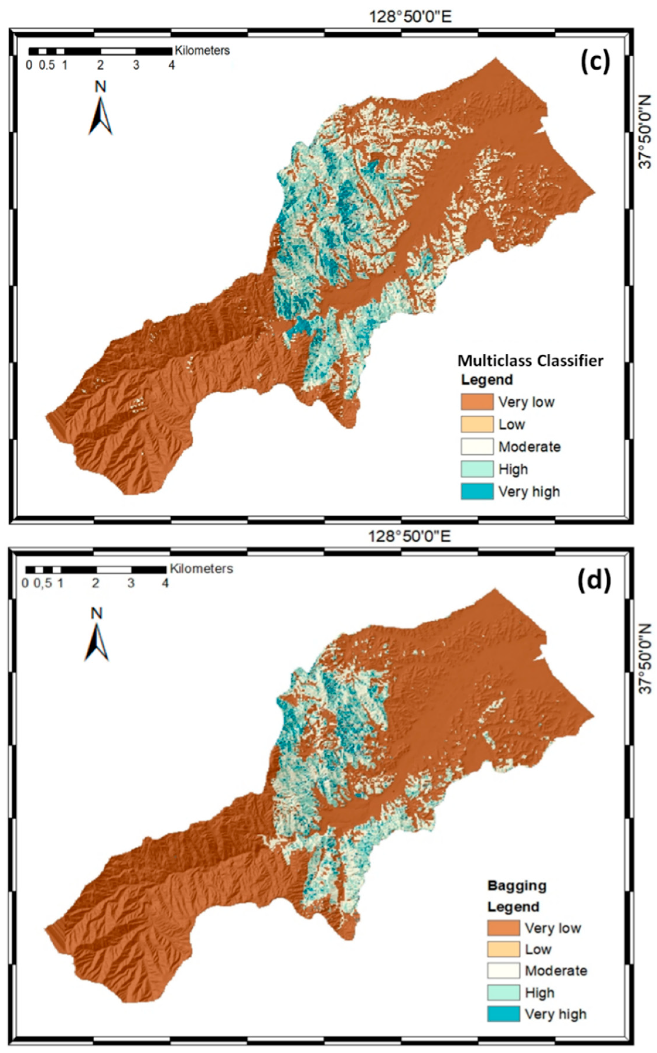
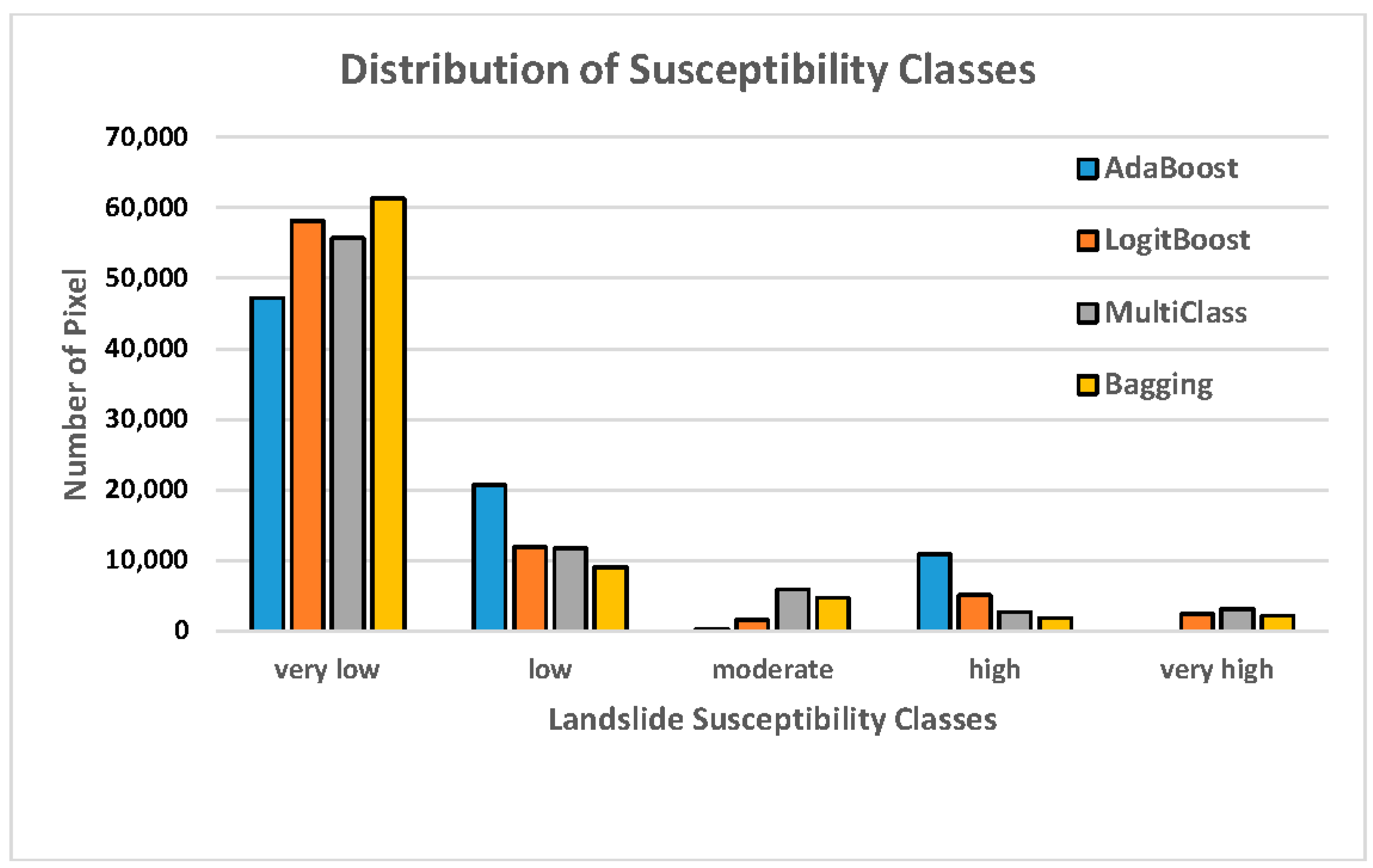
4.1. Landslide Susceptibility Map Construction
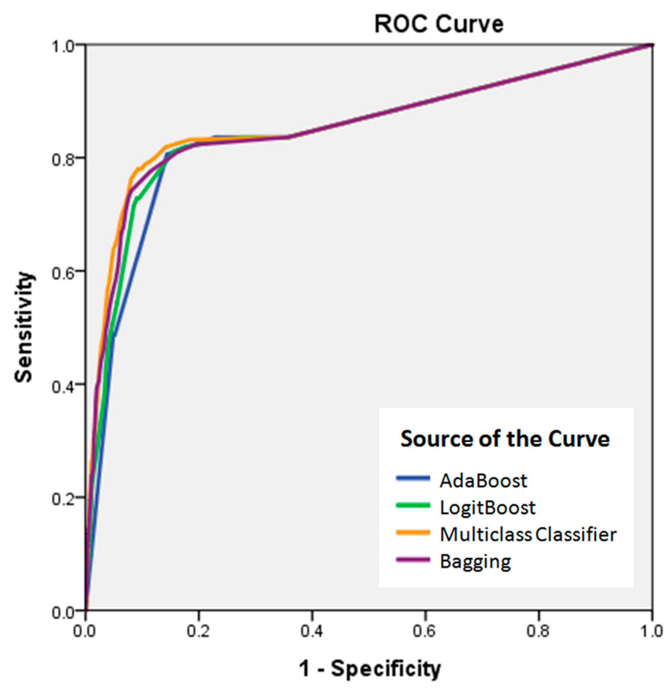
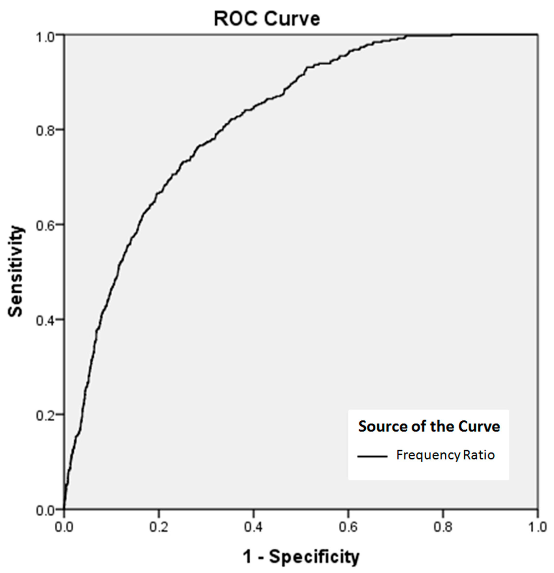
4.2.Map Validation and Accuracy Assessment
5. Discussion
6. Conclusions
Author Contributions
Funding
Acknowledgments
Conflicts of Interest
References
- Lee, S.; Seong, W.J.; Oh, K.Y.; Lee, M.J. The spatial prediction of landslide susceptibility applying artificial neural network and logistic regression models: A case study of Inje, Korea. Open Geosci. 2016, 8, 117–132. [Google Scholar] [CrossRef] [Scilit]
- Kim, K.S.; Song, Y.S. Geometrical and geotechnical characteristics of landslides in Korea under various geological conditions. J. Mt. Sci. 2015, 12, 1267–1280. [Google Scholar] [CrossRef] [Scilit]
- Aleotti, P.; Chowdhury, R. Landslide hazard assessment: Summary review and new perspectives. Bull. Eng. Geol. Environ. 1999, 58, 21–44. [Google Scholar] [CrossRef] [Scilit]
- Wang, L.J.; Guo, M.; Sawada, K.; Lin, J.; Zhang, J. Landslide susceptibility mapping in Mizunami City, Japan: A comparison between logistic regression, bivariate statistical analysis and multivariate adaptive regression spline models. Catena 2015, 135, 271–282. [Google Scholar] [CrossRef] [Scilit]
- Tien Bui, D.; Ho, T.C.; Pradhan, B.; Pham, B.T.; Nhu, V.H.; Revhaug, I. GIS-based modeling of rainfall-induced landslides using data mining-based functional trees classifier with AdaBoost, Bagging, and MultiBoost ensemble frameworks. Environ. Earth Sci. 2016, 75, 1–22. [Google Scholar] [CrossRef] [Scilit]
- Crosta, G.B.; Imposimato, S.; Roddeman, D.G. Numerical modelling of large landslides stability and run out. Nat. Hazards Earth Syst. Sci. 2003, 3, 523–538. [Google Scholar] [CrossRef] [Scilit]
- Di, B.; Stamatopoulos, C.A.; Dandoulaki, M.; Stavrogiannopoulou, E.; Zhang, M. A method predicting the earthquake-induced landslide risk by back analyses of past landslides and its application in the region of the Wenchuan 12/5/2008 earthquake. Nat. Hazards 2017, 85, 903–927. [Google Scholar] [CrossRef] [Scilit]
- McDougall, S.; Hungr, O. A model for the analysis of rapid landslide motion across three-dimensional terrain. Can. Geotech. J. 2004, 41, 1084–1097. [Google Scholar] [CrossRef] [Scilit]
- Pastor, M.; Haddad, B.; Sorbino, G.; Cuomo, S.; Drempetic, V. A depth-integrated coupled SPH model for flow-like landslides and related phenomena. Int. J. Numer. Anal. Methods Geomech. 2009, 33, 143–172. [Google Scholar] [CrossRef] [Scilit]
- Stamatopoulos, C.; Di, B. Analytical and approximate expressions predicting post-failure landslide displacement using the multi-block model and energy methods. Landslides 2015, 12, 1207–1213. [Google Scholar] [CrossRef] [Scilit]
- Lee, S.; Hwang, J.; Park, I. Application of data-driven evidential belief functions to landslide susceptibility mapping in Jinbu, Korea. Catena 2013, 100, 15–30. [Google Scholar] [CrossRef] [Scilit]
- Oh, H.J.; Lee, S.; Hong, S.M. Landslide susceptibility assessment using frequency ratio technique with iterative random sampling. J. Sens. 2017, 2017, 21. [Google Scholar] [CrossRef] [Scilit]
- Pradhan, A.M.S.; Kang, H.S.; Lee, S.; Kim, Y.T. Spatial model integration for shallow landslide susceptibility and its run out using a GIS-based approach in Yongin, Korea. Geocarto Int. 2017, 32, 420–441. [Google Scholar] [CrossRef] [Scilit]
- Oh, H.J.; Lee, S. Shallow landslide susceptibility modeling using the data mining models artificial neural network and boosted tree. Appl. Sci. 2017, 7, 1000. [Google Scholar] [CrossRef] [Scilit]
- Tien Bui, D.; Tuan, T.A.; Klempe, H.; Pradhan, B.; Revhaug, I. Spatial prediction models for shallow landslide hazards: A comparative assessment of the efficacy of support vector machines, artificial neural networks, kernel logistic regression, and logistic model tree. Landslides 2015, 13, 361–378. [Google Scholar] [CrossRef] [Scilit]
- Aditian, A.; Kubota, T.; Shinohara, Y. Comparison of GIS-based landslide susceptibility models using frequency ratio, logistic regression, and artificial neural network in a tertiary region of Ambon, Indonesia. Geomorphology 2018, 318, 101–111. [Google Scholar] [CrossRef] [Scilit]
- Lee, S.; Won, J.S.; Jeon, S.W.; Park, I.; Lee, M.J. Spatial landslide hazard prediction using rainfall probability and a logistic regression model. Math. Geosci. 2015, 47, 565–589. [Google Scholar] [CrossRef] [Scilit]
- Regmi, N.R.; Giardino, J.R.; McDonald, E.V.; Vitek, J.D. A comparison of logistic regression-based models of susceptibility to landslides in western Colorado, USA. Landslides 2014, 11, 247–262. [Google Scholar] [CrossRef] [Scilit]
- Chen, W.; Pourghasemi, H.R.; Zhao, Z. A GIS-based comparative study of Dempster-Shafer, logistic regression and artificial neural network models for landlside susceptibility mapping. Geocarto Int. 2017, 32, 367–385. [Google Scholar] [CrossRef] [Scilit]
- Kim, J.C.; Lee, S.; Jung, H.S.; Lee, S. Landslide susceptibility mapping using random forest and boosted tree models in Pyeong-Chang, Korea. Geocarto Int. 2017, 2017, 1–16. [Google Scholar] [CrossRef] [Scilit]
- Pradhan, B. A comparative study on the predictive ability of the decision tree, support vector machine and neuro-fuzzy models in landslide susceptibility mapping using GIS. Comput. Geosci. 2013, 51, 350–365. [Google Scholar] [CrossRef] [Scilit]
- Pham, B.T.; Khosravi, K.; Prakash, I. Application and comparison of decision tree-based machine learning methods in landslide susceptibility assessment at Pauri Garhwal area, Uttarakhand, India. Environ. Process. 2017, 4, 711–730. [Google Scholar] [CrossRef] [Scilit]
- Kavzoglu, T.; Sahin, E.K.; Colkesen, I. Landslide susceptibility mapping using GIS based multi-criteria decision analysis, support vector machines, and logistic regression. Landslides 2014, 11, 425–439. [Google Scholar] [CrossRef] [Scilit]
- Lee, S.; Hong, S.; Jung, H. A support vector machine for landslide susceptibility mapping in Gangwon province, Korea. Sustainability 2017, 9, 48. [Google Scholar] [CrossRef] [Scilit]
- Kalantar, B.; Pradhan, B.; Naghibi, S.A.; Motevalli, A.; Mansor, S. Assessment of the effects of training data selection on the landslide susceptibility mapping: A comparison between support vector machine (SVM), logistic regression (LR) and artificial neural network (ANN). Geomat. Nat. Hazard Risk 2018, 9, 49–69. [Google Scholar] [CrossRef] [Scilit]
- Lee, S.; Song, K.Y.; Oh, H.J.; Choi, J. Detection of landslide using web-based aerial photographs and landslide susceptibility mapping using geospatial analysis. Int. J. Remote Sens. 2012, 33, 4937–4966. [Google Scholar] [CrossRef] [Scilit]
- Lee, S.; Oh, H.J. Ensemble based landslide susceptibility maps in Jinbu area, Korea. In Terrigenous Mass Movements; Pradhan, B., Buchroithner, M., Eds.; Springer: Berlin\Heidelberg, Germany, 2012; Volume 67, pp. 193–220. ISBN 978-3-642-25494-9. [Google Scholar]
- Rokach, L. Ensemble-based classifiers. Artif. Intell. Rev. 2010, 33, 1–39. [Google Scholar] [CrossRef] [Scilit]
- Rodriguez, J.J.; Kuncheva, L.I.; Alonso, C.J. Rotation forest: A new classifier ensemble method. IEEE Trans. Pattern Anal. Mach. Intell. 2006, 28, 1619–1630. [Google Scholar] [CrossRef] [Scilit] [PubMed]
- Breiman, L. Bagging predictors. Mach. Learn. 1996, 24, 123–140. [Google Scholar] [CrossRef] [Scilit]
- Freund, Y.; Schapire, R. A decision-theoretic generalization of on-line learning and an application to boosting. J. Comput. Syst. Sci. 1997, 55, 119–139. [Google Scholar] [CrossRef] [Scilit]
- Webb, G.I. MultiBoosting: A technique for combining boosting and wagging. Mach. Learn. 2000, 40, 159–196. [Google Scholar] [CrossRef] [Scilit]
- Shun, B.; Wenjia, W. Investigation on diversity in homogenous and heterogeneous ensembles. In Proceedings of the 2006 IEEE International Joint Conference on Neural Network Proceedings, Vancouver, BC, Canada, 16–21 July 2006. [Google Scholar]
- Maudes, J.; Rodriguez, J.J.; Garcia-Osorio, C.; Garcia-Pedrajas, N. Random feature weights for decision tree ensemble construction. Inf. Fusion 2012, 13, 20–30. [Google Scholar] [CrossRef] [Scilit]
- Tien Bui, D.; Tien Ho, C.; Revhaug, I.; Pradhan, B.; Duy Nguyen, B. Landslide susceptibility mapping along the national road 32 of Vietnam using GIS-based j48 decision tree classifier and its ensembles. In Geoinformation and Cartography; Buchroithner, M., Prechtel, N., Burghardt, D., Eds.; Springer: Berlin/Heidelberg, Germany, 2014; pp. 303–317. ISBN 978-3-642-32618-9. [Google Scholar]
- Pham, B.T.; Tien Bui, D.; Dholakia, M.B.; Prakash, I.; Pham, H.V.; Mehmood, K.; Le, H.Q. A novel ensemble classifier of rotation forest and naive bayes for landslide susceptibility assessment at the Luc Yen district, Yen Bai province (Vietnam) using GIS. Geomat. Nat. Hazard Risk 2017, 8, 649–671. [Google Scholar] [CrossRef] [Scilit]
- Hong, H.; Liu, J.; Tien Bui, D.; Pradhan, B.; Acharya, T.D.; Pham, B.T.; Zhu, A.; Chen, W.; Ahmad, B.B. Landslide susceptibility mapping using J48 decision tree with adaboost, bagging and rotation forest ensembles in the Guangchang area (China). Catena 2018, 163, 399–413. [Google Scholar] [CrossRef] [Scilit]
- Bouckaert, R.R.; Frank, E.; Hall, M.; Kirkby, R.; Reutemann, P.; Seewald, A.; Scuse, D. WEKA Manual for Version 3-7-8; University of Waikato: Hamilton, New Zealand, 2013; pp. 29–166. [Google Scholar]
- Lee, S.; Lee, M.J. Detecting landslide location using KOMPSAT 1 and its application to landslide susceptibility mapping at the Gangneung area, Korea. Adv. Space Res. 2006, 38, 2261–2271. [Google Scholar] [CrossRef] [Scilit]
- Earth Explorer USGS. Available online: https://www.earthexplorer.usgs.gov/ (accessed on 8 August 2018).
- Guzzetti, F. Landslide fatalities and the evaluation of landslide risk in Italy. Eng. Geol. 2000, 58, 89–107. [Google Scholar] [CrossRef] [Scilit]
- Ercanoglu, M.; Gokceoglu, C. Use of fuzzy relations to produce landslide susceptibility map of a landslide prone area (West Black Sea Region, Turkey). Eng. Geol. 2004, 75, 229–250. [Google Scholar] [CrossRef] [Scilit]
- Daum map. Available online: http://map.daum.net (accessed on 5 June 2018).
- Conrad, O.; Bechtel, B.; Bock, M.; Dietrich, H.; Fischer, E.; Gerlitz, L.; Wehberg, J.; Wichmann, V.; Bohner, J. System for Automated Geoscientific Analysis (SAGA) v. 2.1.4. Geosci. Model Dev. 2015, 8, 1991–2007. [Google Scholar] [CrossRef] [Scilit]
- Moore, I.D.; Grayson, R.B.; Landson, A.R. Digital terrain modelling: A review of hydrological, geomorphological, and biological applications. Hydrol. Process. 1991, 5, 3–30. [Google Scholar] [CrossRef] [Scilit]
- De Reu, J.; Bourgeois, J.; Bats, M.; Zwertaegher, A.; Gelorini, V.; De Smedt, P.; Chu, W.; Antrop, M.; De Maeyer, P.; Finke, P.; et al. Application of the topographic position index to heterogeneous landscapes. Geomorphology 2013, 186, 29–49. [Google Scholar] [CrossRef] [Scilit]
- Schmidt, K.M.; Roering, J.J.; Stock, J.D.; Dietrich, W.E.; Montgomery, D.R.; Schaub, T. The variability of root cohesion as an influence on shallow landslide susceptibility in the Oregon Coast Range. Can. Geotech. J. 2001, 38, 995–1024. [Google Scholar] [CrossRef]
- Anbalagan, R. Landslide hazard evaluation and zonation mapping in mountainous terrain. Eng. Geol. 1992, 32, 269–277. [Google Scholar] [CrossRef] [Scilit]
- Carrara, A.; Cardinalli, M.; Detti, R.; Guzetti, F.; Pasqui, V.; Reichenbach, P. GIS techniques and statistical models in evaluating landslide hazard. Earth Surf. Process. Landf. 1991, 16, 427–445. [Google Scholar] [CrossRef] [Scilit]
- Dai, F.C.; Lee, C.F.; Xu, Z.W. Assessment of landslide susceptibility on the natural terrain of Lantau Island, Hong Kong. Environ. Geol. 2001, 40, 381–391. [Google Scholar] [CrossRef] [Scilit]
- Pachauri, A.K.; Gupta, P.V.; Chander, R. Landslide zoning in a part of the Garhwal Himalayas. Environ. Geol. 1998, 36, 325–334. [Google Scholar] [CrossRef] [Scilit]
- Bui, D.T.; Pradhan, B.; Nampak, H.; Bui, T.Q.; Tran, Q.A.; Nguyen, Q.P. Hybrid artificial intelligence approach based on neural fuzzy inference model and Meta-heuristic optimization for flood susceptibility modelling in a high-frequency tropical cyclone area using GIS. J. Hydrol. 2016, 540, 317–330. [Google Scholar] [CrossRef] [Scilit]
- Friedman, J.; Hastie, T.; Tibshirani, R. Additive logistic regression: A statistical view of boosting (with discussion and rejoinder by the authors). Ann. Stat. 2000, 28, 337–407. [Google Scholar] [CrossRef]
- Kowsari, K.; Brown, D.E.; Heidarysafa, M.; Meimandi, K.J.; Gerber, M.S.; Barnes, L.E. HDLTex: Hierarchical deep learning for text classification. In Proceedings of the 16th IEEE International Conference on Machine Learning and Applications (ICMLA), Cancun, Mexico, 18–21 December 2017; pp. 364–371. [Google Scholar]
- Irigaray, C.; Fernandez, T.; El Hamdouni, R.; Chacón, J. Evaluation and validation of landslide-susceptibility maps obtained by a GIS matrix method: Examples from the Betic Cordillera (southern Spain). Nat. Hazards 2007, 41, 61–79. [Google Scholar] [CrossRef] [Scilit]
- Kuncheva, L.I. Combining Pattern Classifiers: Methods and Algorithms; John Wiley & Sons, Inc.: Hoboken, NJ, USA, 2004; pp. 203–234. ISBN 0-471-21078-1. [Google Scholar]

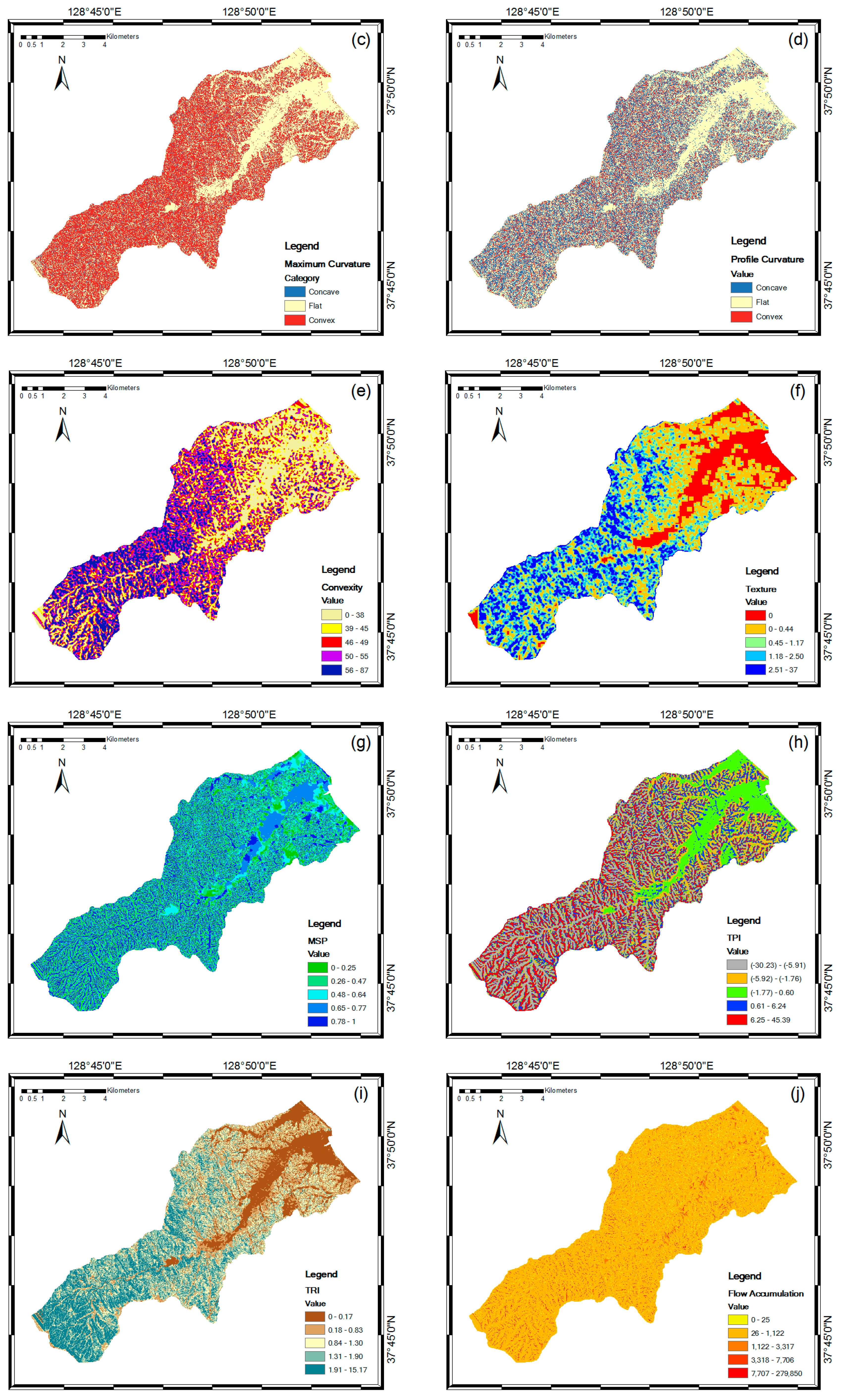
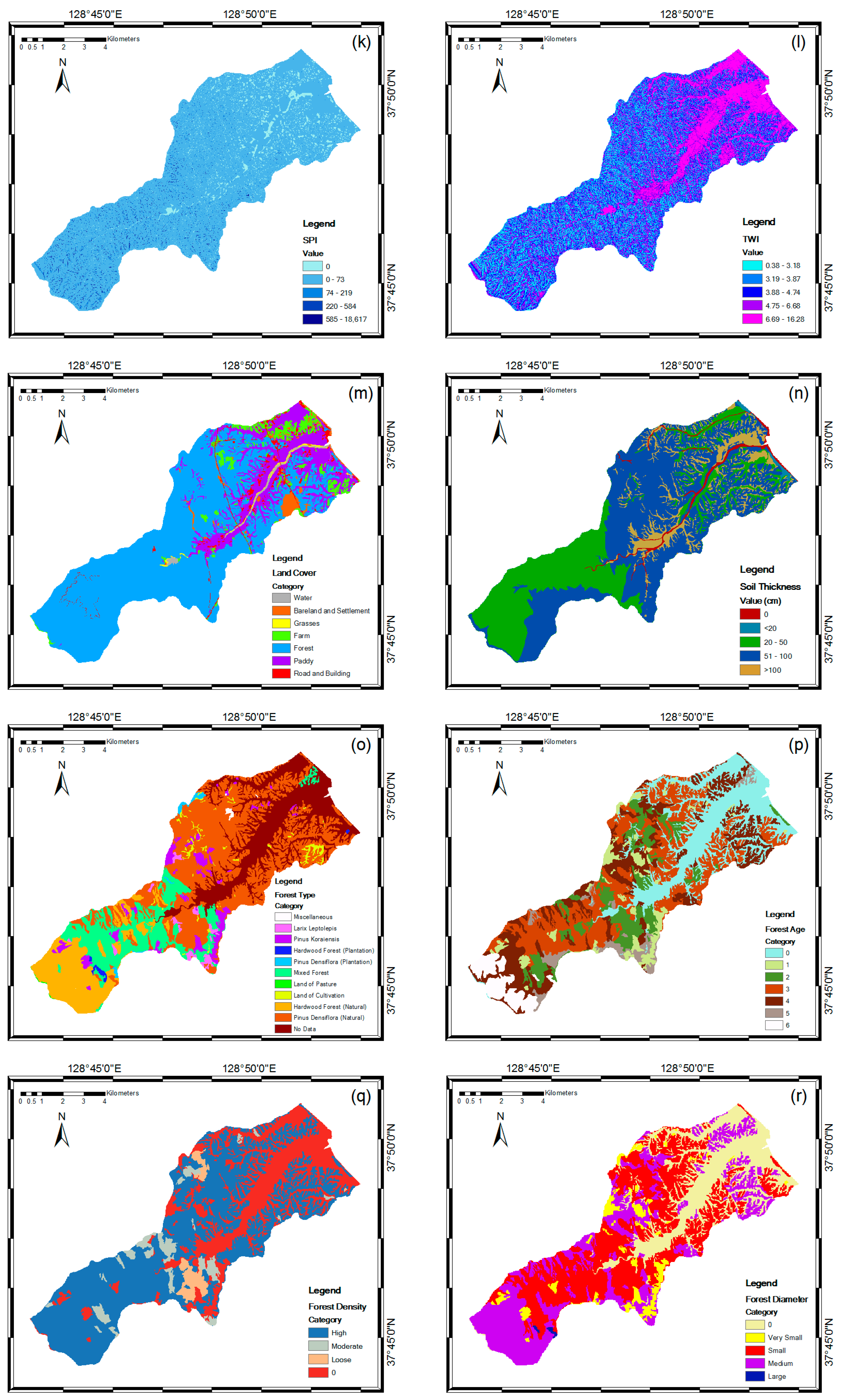
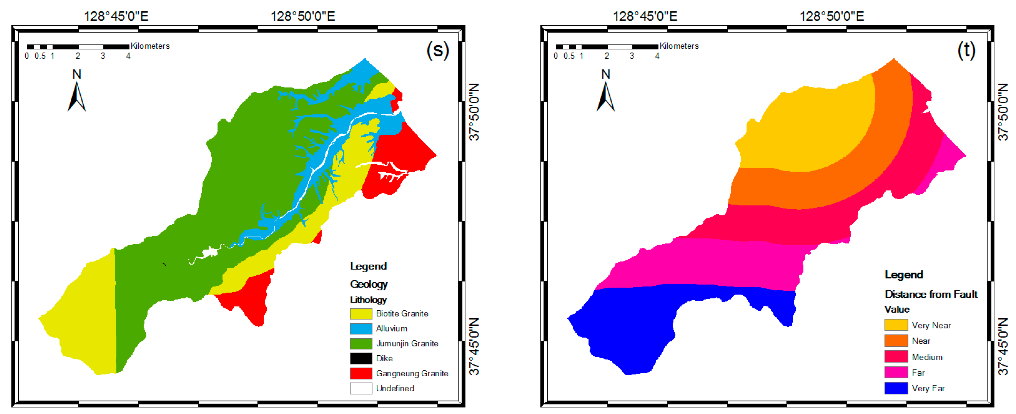

| Category | Factor | Data Type | Scale | Source |
|---|---|---|---|---|
| Topographic factors | Slope Aspect Maximum curvature Convexity Texture Mid-slope position Terrain ruggedness index Topographic position index | Grid 1 | 1:5000 | National Geographic Information Institute |
| Hydrologic factors | Flow accumulation Stream power index Topographic wetness index | Grid 1 | 1:5000 | National Geographic Information Institute |
| Land cover factors | Land use | Polygon 2 | 1:5000 | National Academy of Agricultural Science |
| Soil factors | Soil thickness | Polygon 2 | 1:5000 | National Academy of Agricultural Science |
| Forest factors | Forest type Forest age Forest density Forest diameter | Polygon 2 | 1:5000 | Korea Forest Research Institute |
| Geological factors | Lithology Distance from fault | Polygon 2 | 1:25,000 | Korean Institute of Geoscience and Mineral Resources |
| Algorithm | Parameters |
|---|---|
| AdaBoost | Number of iterations, 10; Seed, 1; Percentage of weight mass, 100. |
| LogitBoost | Number of iterations, 10; Seed, 1; Percentage of weight mass, 100; Threshold of likelihood, −1.7976E308; Shrinkage, 1; Max threshold, 3; Thread pool, 1; Thread to batch prediction, 1. |
| Multiclass Classifier | Seed, 1; Number of method use, 0; Number of multipliers, 2; Ridge in the log-likelihood, 1.0E-8; Max number of iterations, −1. |
| Bagging | Number of iterations, 10; Seed, 1; Percentage of weight mass, 100; Number of execution slots, 1; Minimum number of instances, 2; Minimum variance for split, 0.001; Number of folds, 3; Maximum tree depth, −1. |
| Algorithm | AUC (Area Under the Curve) |
|---|---|
| AdaBoost | 0.840 1 |
| LogitBoost | 0.848 1 |
| Multiclass Classifier | 0.859 1 |
| Bagging | 0.854 1 |
© 2018 by the authors. Licensee MDPI, Basel, Switzerland. This article is an open access article distributed under the terms and conditions of the Creative Commons Attribution (CC BY) license (http://creativecommons.org/licenses/by/4.0/).
Share and Cite
Kadavi, P.R.; Lee, C.-W.; Lee, S. Application of Ensemble-Based Machine Learning Models to Landslide Susceptibility Mapping. Remote Sens. 2018, 10, 1252. https://doi.org/10.3390/rs10081252
Kadavi PR, Lee C-W, Lee S. Application of Ensemble-Based Machine Learning Models to Landslide Susceptibility Mapping. Remote Sensing. 2018; 10(8):1252. https://doi.org/10.3390/rs10081252
Chicago/Turabian StyleKadavi, Prima Riza, Chang-Wook Lee, and Saro Lee. 2018. "Application of Ensemble-Based Machine Learning Models to Landslide Susceptibility Mapping" Remote Sensing 10, no. 8: 1252. https://doi.org/10.3390/rs10081252
APA StyleKadavi, P. R., Lee, C.-W., & Lee, S. (2018). Application of Ensemble-Based Machine Learning Models to Landslide Susceptibility Mapping. Remote Sensing, 10(8), 1252. https://doi.org/10.3390/rs10081252