1. Introduction
Contemporary architectural practice is expected to produce environments that are at once sustainable and people-centered, attending not only to the building envelope but also to the immediate outdoor space through which people move, pause and dwell. In architectural education, however, the open space surrounding a building can be treated as a residual category, and vegetation added at the end of the process as a decorative layer rather than designed as a spatial and environmental device. Emphases differ markedly across schools, curricula and national contexts, and no single account holds universally; nonetheless, this concern recurs widely enough in the studio literature to warrant systematic attention. This tendency contrasts with a growing body of evidence showing that the configuration of outdoor space and the strategic arrangement of vegetation jointly shape pedestrian movement, the emergence of lingering, stationary activity, microclimatic comfort and the perceived quality of public space [
1,
2,
3].
A persistent challenge in the intermediate-level design studio is therefore epistemic rather than merely technical: in many settings, students are able to generate site analysis yet struggle to convert that analysis into justifiable design decisions. Spatial diagrams, flow arrows and integration maps are produced, yet the link between what the analysis reveals and where a tree, hedge or vegetated cover is ultimately placed often remains implicit. The result is a recurrent gap between representation and decision-making that undermines the pedagogical promise of evidence-based design.
Evidence-based design (EBD) responds to this gap by proposing that design decisions should be grounded in credible information about how environments behave and how people use them [
4,
5]. Within the studio, EBD reframes site analysis: from an illustrative ritual it becomes an instrument that actively constrains and justifies form. Among the analytical frameworks compatible with this stance, space syntax offers a particularly transferable vocabulary. Developed from the configurational theory of architecture [
6,
7], space syntax quantifies how the arrangement of spaces relates to movement and co-presence. The measure of choice (betweenness) estimates the likelihood that a route segment lies on the shortest paths between all origin–destination pairs and has been empirically associated with observed pedestrian movement [
7,
8]. Complementary measures such as local integration, connectivity and visual integration, together with isovist analysis [
9,
10], allow students to reason about accessibility, co-visibility and the latent structure of a site.
Vegetation, in turn, is increasingly understood through the lens of nature-based solutions and green infrastructure as an active agent of environmental and spatial performance rather than as ornamental [
11,
12]. Trees and plant masses provide shade and modify the radiant environment [
13,
14], mitigate urban heat [
15,
16] and—when deliberately placed—organize paths, define edges, filter views and support resting places. Coupling a configurational reading of the site with the strategic deployment of vegetation thus offers a coherent route for teaching people-centered, climate-sensitive outdoor design.
Despite the maturity of each individual field, there is little pedagogical research that explicitly examines how students operationalize space-syntax indicators into vegetation decisions, and how such reasoning can be assessed in a structured, replicable way. Most studio accounts remain anecdotal, describing an exercise without systematically analyzing student performance or proposing a transferable instrument. This study addresses that gap by treating a single, well-bounded studio exercise as a methodological case for evidence-based sustainable design education.
Accordingly, the study pursues the following objective: to evaluate how intermediate-level architectural design students translate space-syntax indicators into strategic vegetation decisions to organize pedestrian paths, pause areas, visual filters and environmental comfort in a minimal sustainable shelter project, and to derive a replicable pedagogical model from the resulting patterns.
The study is guided by three research questions:
RQ1. How do intermediate-level architecture students interpret and represent space-syntax indicators—particularly choice/betweenness, local integration and visual integration—when reading the site of an urban park?
RQ2. How do students translate those indicators into strategic vegetation decisions to organize paths, pauses, visual filters and environmental comfort?
RQ3. Which rubric dimensions reveal the greatest strengths and weaknesses, and what do these patterns imply for teaching evidence-based sustainable design in intermediate studios?
The contribution is explicitly methodological and pedagogical. Rather than evaluating student drawings as such, the study proposes and tests a replicable procedure—an analytic rubric coupled with content-analysis coding—to make visible the reasoning by which spatial evidence becomes a landscape decision. By situating learning in public space and in the relationship among paths, pauses and vegetation, the study aligns with the agenda of socially sustainable urban and architectural design, understanding the education of future architects as a lever for producing more livable, inclusive and people-centered outdoor environments. The exploratory nature of the design, the small sample and the single-site context are acknowledged throughout, and claims are framed cautiously.
The remainder of the manuscript is organized as follows.
Section 2 reviews the literature on space syntax and evidence-based design, strategic vegetation and people-centered outdoor comfort, sustainable studio pedagogy, and the gap between representation and design decision-making.
Section 3 details the materials and methods, including the research design, educational context, case-study site, design brief, sample, assessment rubric, and the quantitative and qualitative analysis procedures.
Section 4 reports the results, from the descriptive analysis of rubric scores to the recurrent vegetation strategies and performance patterns.
Section 5 discusses the findings, derives a four-phase didactic protocol for the studio (
Section 5.1) and outlines a validation agenda and future work (
Section 5.2).
Section 6 presents the conclusions, returning explicitly to the three research questions.
3. Materials and Methods
3.1. Research Design
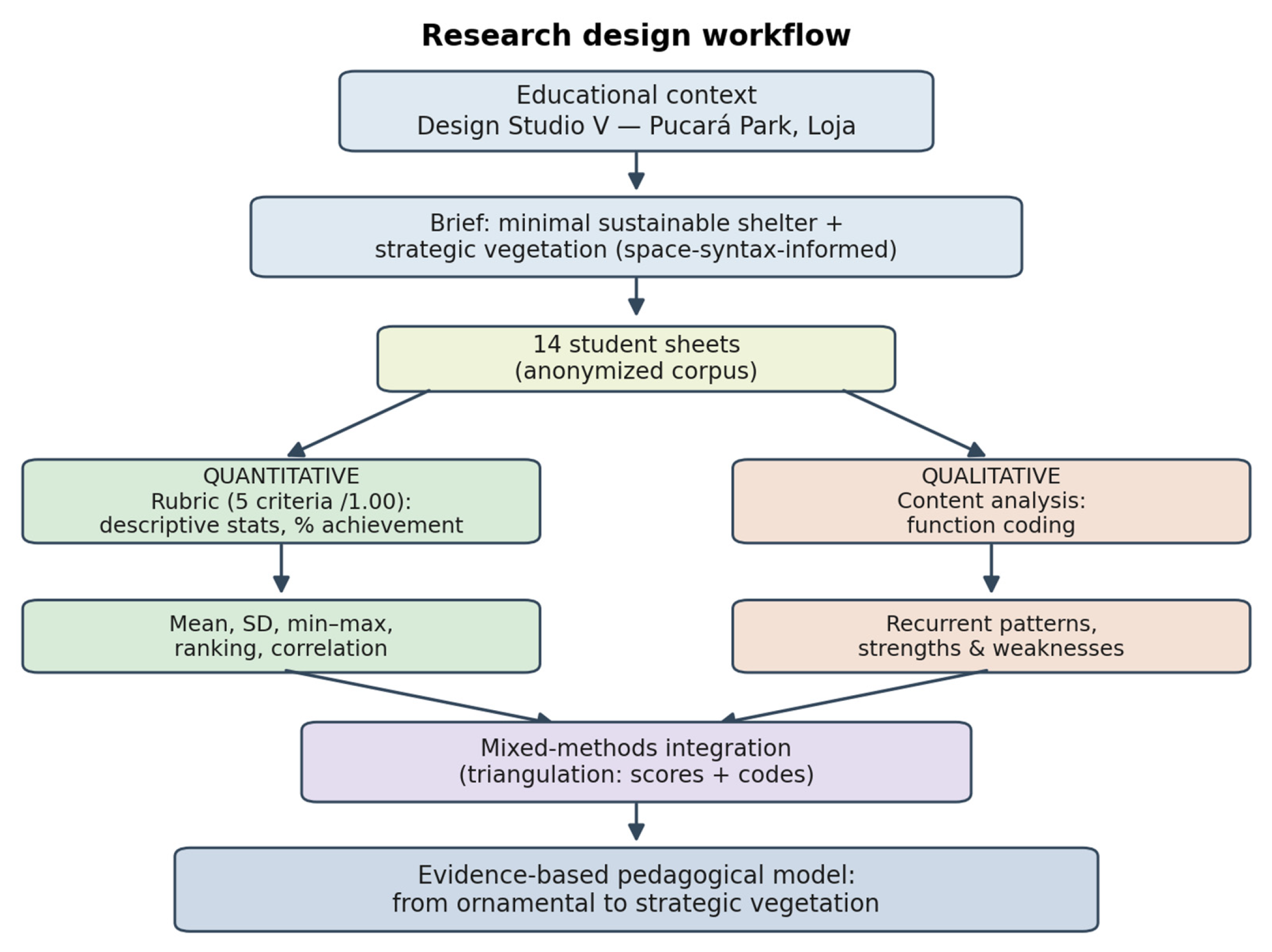
This study adopts an exploratory, convergent mixed-methods design [
47] in which a quantitative strand (rubric scoring) and a qualitative strand (content-analysis coding of the sheets) are analyzed separately and then integrated through triangulation. The unit of analysis is the individual student sheet produced for a single studio examination. The design is deliberately framed as a methodological and pedagogical case rather than a generalizable experiment; its purpose is to test a replicable instrument and characterize reasoning patterns. The overall workflow is summarized in
Figure 1.
3.2. Educational Context
The exercise was carried out in Architectural Design Studio V, Section D, of the Architecture program at Universidad Técnica Particular de Loja (UTPL), Ecuador. Studio V is an intermediate-level course in which students consolidate the integration of site analysis, environmental reasoning and architectural form. The exercise corresponded to the first-term examination (Week 8), entitled “First-term examination V2: paths, pauses and strategic vegetation,” and was carried out individually under examination conditions.
3.3. Case Study: Pucará Park, Loja
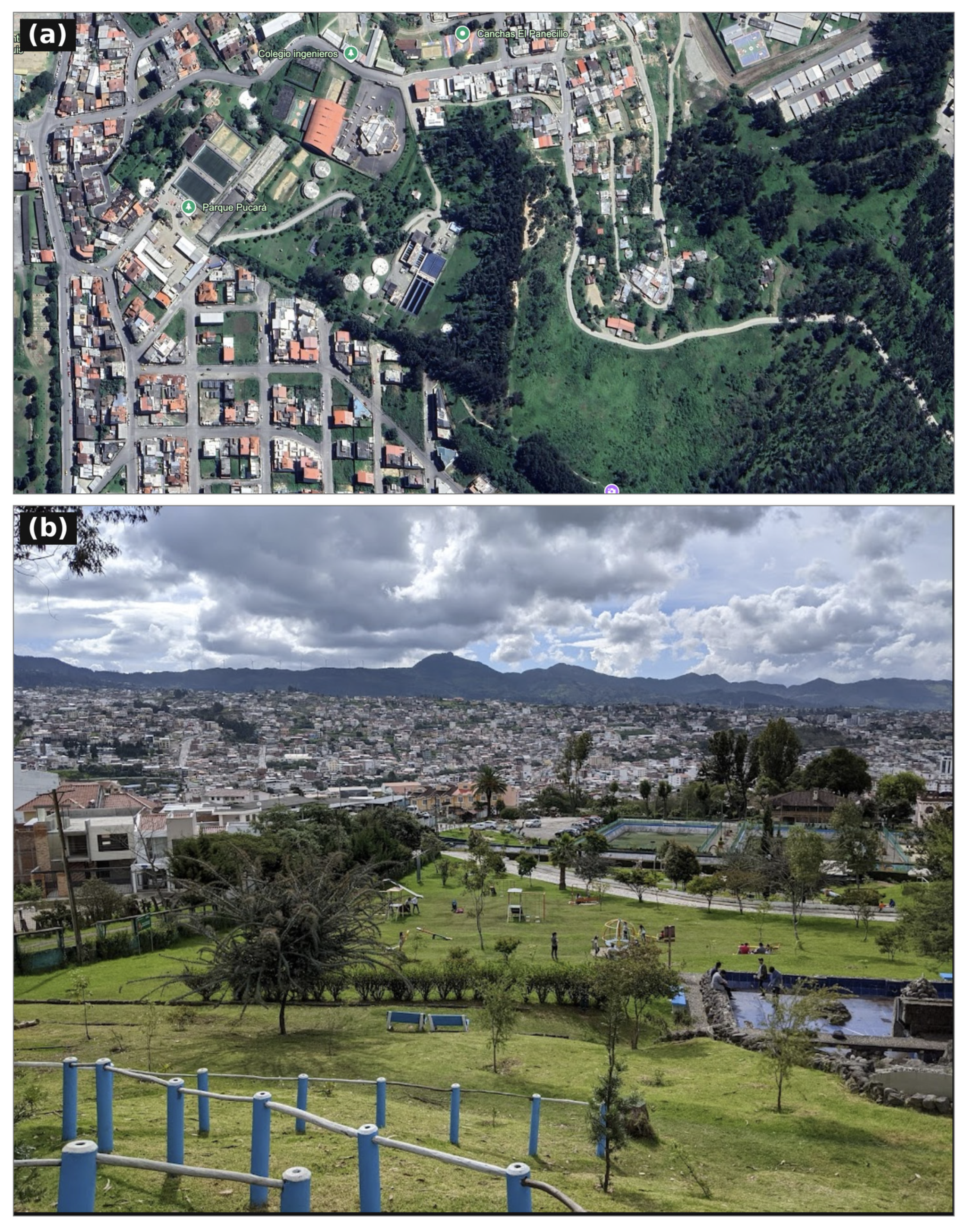
The site was Pucará Park, an urban park in the city of Loja, located in the southern Andean highlands of Ecuador at an altitude of approximately 2060 m above sea level. The city has a temperate mountain climate with moderate diurnal temperature ranges and significant solar exposure, conditions under which shade, wind protection and the control of solar gain are relevant design concerns [
48]. As a public park crossed by multiple pedestrian routes and bounded by the surrounding urban fabric, the site offered a legible configurational structure—primary and secondary paths, access points and potential pause areas—well suited to a space-syntax reading.
Figure 2 situates the park within the urban fabric of Loja and shows its general setting; its network of pedestrian routes, access points and potential pause areas made it suitable for the exercise.
3.4. Design Brief
Each student was required to site a minimal sustainable shelter (a small, low-impact architectural module) within Pucará Park and, on the basis of a spatial reading of the site, develop a strategic vegetation proposal. Vegetation was not to be used as decoration but as a design strategy linked to the structure of the place, pedestrian flows, views and solar orientation. Specifically, vegetation was expected to organize paths, create pause areas, establish filters between public space and the module, control views and improve environmental comfort, thereby linking planting, accessibility, shade and pedestrian experience.
The primary analytical indicator was choice/betweenness, understood as a means of identifying routes most likely to carry through-pedestrian movement. Students could complement it with local integration, visual integration, connectivity, isovists, the reading of pauses, a hierarchy of paths, primary and secondary accesses, and transition, waiting or resting zones. The deliverable was a single analytical–design sheet synthesizing the site reading, the module siting and the vegetation strategy with a brief written justification.
3.5. Sample
The corpus comprised fourteen student sheets (N = 14), corresponding to all students who sat the examination in the section. All sheets were anonymized before analysis and are referenced by neutral identifiers (S01–S14); no personally identifiable information is reported. Given the census nature of the sample within a single section, the results characterize this cohort and do not claim statistical generalization.
3.6. Assessment Rubric
The sheets were assessed with an analytic rubric scored out of a maximum of 1.00 point, comprising five weighted criteria summarized in
Table 1. The criteria were designed in constructive alignment with the intended learning outcomes of the exercise, covering spatial reading, coherence of siting with paths and pauses, functional use of vegetation, graphic communication and the quality of the design justification. The vegetation criterion received the highest weight (0.25), reflecting the central learning objective of the exercise. The weighting was derived from the principle of constructive alignment [
44], whereby assessment weight should mirror the relative emphasis of the intended learning outcomes rather than being distributed uniformly. Because the exercise was explicitly designed to teach the strategic, functional use of vegetation, the vegetation-function criterion was assigned the single highest weight (0.25); the two criteria that capture the configurational reasoning the exercise sought to build—spatial analysis and the coherence between siting, paths and pauses—were each weighted at 0.20, as was graphic communication, the medium through which that reasoning is made legible and assessable; design justification, treated as a synthesizing competence layered on the preceding four, received 0.15. The weights were therefore set deductively from the learning objectives rather than from external industry standards, which do not prescribe weightings for this type of formative studio assessment. We acknowledge that this allocation reflects an instructor judgment; accordingly, a planned line of future work is to calibrate the weights empirically, for example through a Delphi-type consultation with studio instructors and a student-perception survey, and to test the sensitivity of the achievement ranking to alternative weighting schemes.
3.7. Quantitative Analysis
For each criterion and for the total score, descriptive statistics were computed: mean, standard deviation (SD), minimum, maximum and median. To allow comparison across criteria with different maxima, achievement was expressed as a percentage of each criterion’s maximum score. The internal consistency of the rubric was assessed with Cronbach’s alpha. Because each student was scored on all five criteria (repeated measures), differences in proportional achievement across criteria were tested with the Friedman test, accompanied by Kendall’s W as an effect size and by pairwise comparisons using the Wilcoxon signed-rank test. The association between spatial-analysis and vegetation-function scores was estimated with Spearman’s correlation coefficient, with a 95% confidence interval obtained by bootstrap resampling (5000 replicates). Given the small sample size (N = 14), results are interpreted cautiously as exploratory and non-confirmatory. Analyses were performed in R (version 4.6.1; R Foundation for Statistical Computing, Vienna, Austria) (packages psych 2.6.5, stats 4.6.1, rstatix 0.7.3 and boot 1.3-32).
3.8. Qualitative Coding
A directed (deductive–inductive) content analysis of the sheets was conducted [
49,
50]. A provisional scheme of vegetation functions was defined a priori from the brief and the literature—shade provision, visual filtering, path guidance, spatial edge or boundary, public–private transition, support for pauses, wind protection, thermal comfort and landscape integration—and refined inductively during coding. Each function corresponds to a documented role of vegetation in the cited literature, grouped into three families. The microclimatic functions—shade provision, wind protection and thermal comfort—derive from research on how planting modifies radiant exchange, air movement and the mean radiant temperature governing outdoor comfort [
13,
14,
27], including evidence from tropical and high-altitude settings [
28,
48]. The spatial-organizational functions—path guidance, spatial edge or boundary, public–private transition and support for pauses—derive from people-centered public-space research in which plant masses channel movement, define edges, frame thresholds and sustain stationary activity [
1,
2]. The perceptual and ecological functions—visual filtering and landscape integration—derive, respectively, from visibility-based accounts of co-visible space [
9,
10] and from the green-infrastructure and nature-based-solutions framing of vegetation as a multifunctional urban asset [
11,
12,
34]. This mapping made the coding categories traceable to specific evidence rather than ad hoc, while the inductive pass allowed any function not anticipated by the scheme to be added; in practice, no additional category was required. Each sheet was coded for the presence of each function, and recurrent patterns, combinations and weaknesses were identified following an iterative thematic logic [
51]. Coding focused on whether a function was explicitly argued and spatially located, rather than merely mentioned.
3.9. Ethical Considerations
The study used academic work generated as part of ordinary teaching. All sheets were anonymized before analysis and no grades associated with student identities are reported. The analysis presents only aggregate statistics and anonymized identifiers, consistent with institutional norms for the secondary educational use of student work.
3.10. Limitations
Several limitations should be acknowledged. The sample is small and drawn from a single section, site and examination, which restricts generalization. Grading was performed by the course instructor, introducing a potential single-rater bias; inter-rater reliability was not assessed, and the qualitative coding was carried out by a single analyst. Finally, the study assesses representations of intended design behavior on examination sheets, not actually realized environmental performance. This last point is a deliberate scope decision rather than an oversight: the object of study is the pedagogical reasoning by which spatial evidence is translated into a design decision, not the in situ environmental efficacy of the resulting proposals. The rubric and coding therefore appraise the soundness and traceability of that reasoning, which can be assessed from the analytical–design sheet, and not the measured microclimatic outcome, which would require a different research design. Coupling the present instrument with microclimatic simulation (for example, ENVI-met (ENVI-met GmbH, Essen, Germany) or comparable tools) or with field measurement is identified as a priority extension in
Section 5.2, so that represented decisions can be connected to predicted or realized environmental performance. These limitations frame the findings as exploratory and hypothesis-generating.
4. Results
4.1. Descriptive Analysis of Rubric Scores
The cohort achieved a mean total score of 0.84 out of 1.00 (SD = 0.06; median = 0.86; range 0.73–0.92), indicating generally solid performance with moderate dispersion. The rubric showed high internal consistency (Cronbach’s α = 0.93), supporting its use as a coherent instrument for appraising design reasoning. Descriptive statistics for each criterion are reported in
Table 2, expressed both in raw points and as a percentage of the criterion maximum, to allow comparison across differently weighted criteria.
4.2. Criterion Ranking and Interpretation
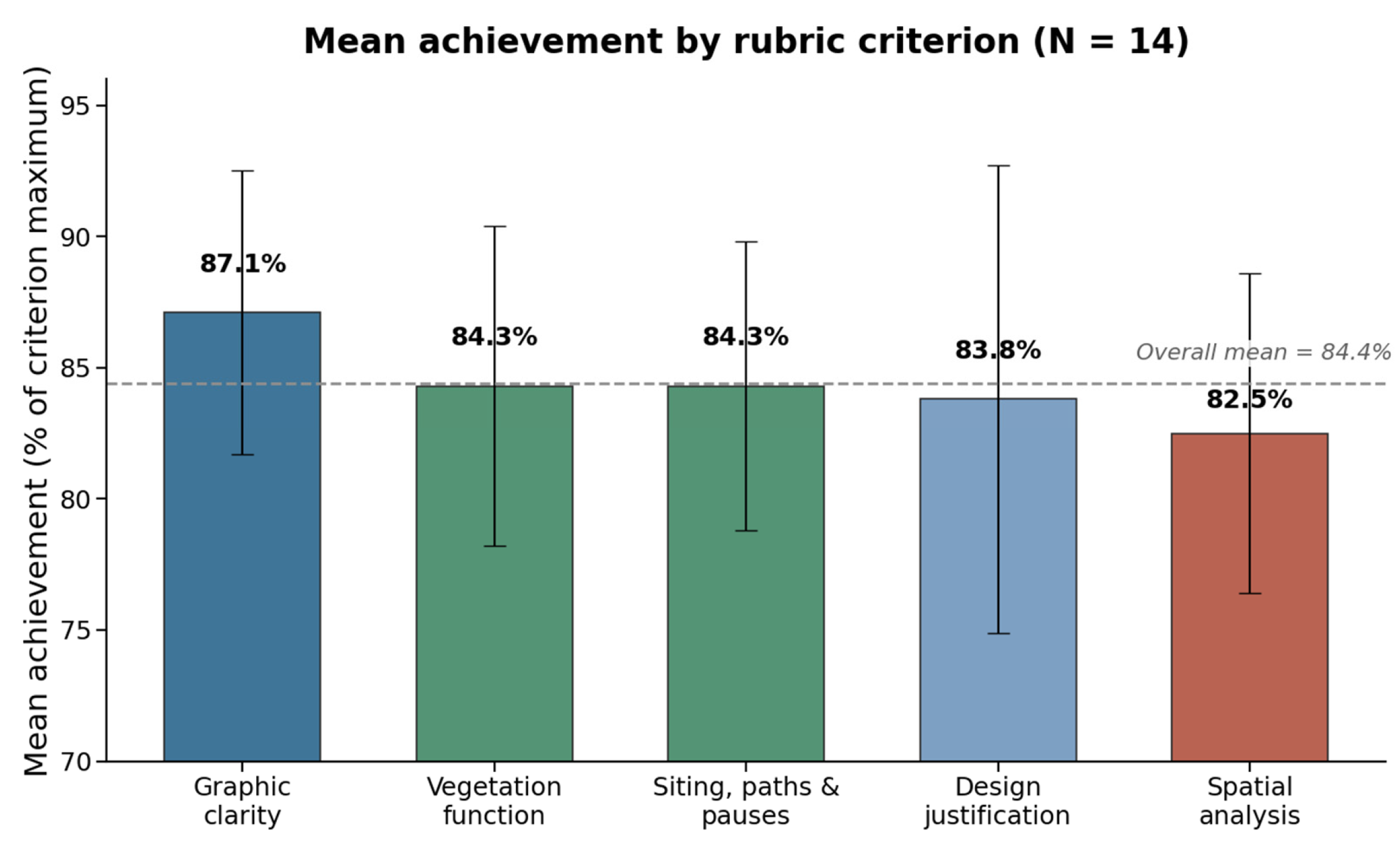
Ranked by achievement percentage, graphic clarity was the strongest dimension (87.1%), followed by vegetation function and siting/paths/pauses (both 84.3%), design justification (83.8%) and, finally, spatial analysis (82.5%). The ranking is visualized in
Figure 3. Two readings of this pattern are warranted. In proportional terms, the criterion students executed most successfully was the communicative quality of the sheet, whereas the reading of spatial analysis—and within it the operational use of choice/betweenness—was comparatively the weakest. At the same time, the vegetation-function criterion, which carried the highest weight and represented the central learning objective, was achieved at a solid 84.3%, suggesting that most students approached vegetation as a functional device rather than ornament.
The relatively small standard deviations across criteria (0.011–0.015 points) indicate a cohort performing within a narrow band, with no criterion showing marked polarization. Nonetheless, the differences in proportional achievement across the five criteria were statistically significant (Friedman test, χ2(4) = 12.54; p = 0.014; Kendall’s W = 0.22), and the pairwise comparison between the strongest and weakest criteria—graphic clarity versus spatial analysis—was significant (Wilcoxon test, p = 0.005). The greatest proportional dispersion occurred in the design-justification criterion, where some sheets offered concise, well-grounded arguments while others provided minimal text.
4.3. Relationship Between Spatial Reading and Vegetation Function
An exploratory analysis examined whether a stronger spatial reading was associated with more functional vegetation. Spatial-analysis and vegetation-function scores showed a moderate, positive Spearman correlation (ρ = 0.61; p = 0.021; 95% bootstrap CI [0.02, 0.96]). Within this cohort, students who read the site more competently tended to deploy vegetation more functionally. The width of the confidence interval—whose lower bound approaches zero—requires the association to be interpreted as suggestive and exploratory rather than conclusive; nonetheless, it is consistent with the study’s central premise that spatial evidence and landscape decision-making are pedagogically linked.
4.4. Recurrent Vegetation Strategies
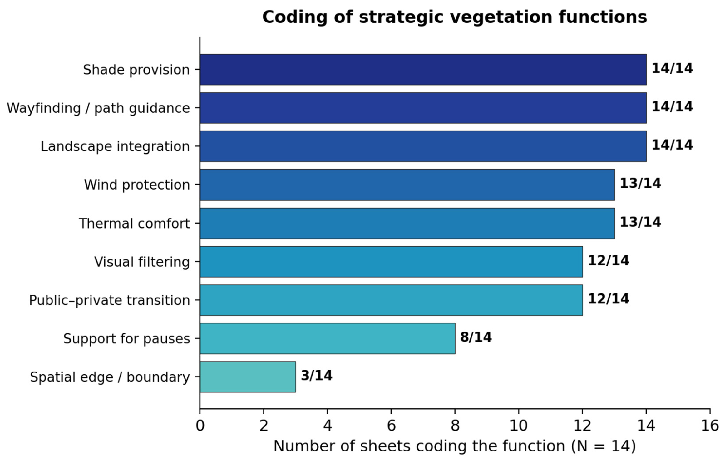
The content analysis identified nine vegetation functions across the sheets; their frequency is shown in
Figure 4. Shade provision, path guidance and landscape integration appeared in every sheet (14/14), followed by wind protection and thermal comfort (both 13/14) and visual filtering and public–private transition (both 12/14). This indicates that students readily mobilized vegetation to modulate solar exposure, accompany paths and regulate microclimate. By contrast, support for pauses (8/14) and, above all, the definition of spatial edges or boundaries (3/14) were the least-coded functions, suggesting that vegetation was used more fluently as an environmental device than as a means to structure and delimit outdoor space.
4.5. Performance Patterns
From the integrated reading of scores and codes, three performance patterns emerged. High-performing sheets explicitly linked spatial analysis to design decisions: paths and accesses identified through choice/integration were used directly to place vegetation that guided movement, framed views and created shaded pause areas, accompanied by a concise justification. Medium-performing sheets showed competent vegetation strategies and clear graphics but presented the spatial analysis and the vegetation proposal as parallel layers, leaving the causal link between them partly implicit. Lower-performing sheets correctly represented the indicators but did not translate them into specific decisions: choice/betweenness appeared as a diagram without governing the placement of either the module or the planting. This gradient corresponds directly to the spatial-analysis criterion as the principal discriminating dimension. Overall, the choice/betweenness indicator was represented in all sheets and operationalized—that is, explicitly used to decide vegetation placement—in 12 of the 14 (85.7%); nonetheless, the depth of that operationalization was uneven, consistent with spatial analysis obtaining the lowest proportional achievement in the rubric.
Three recurrent error types illustrate where the analysis–decision translation broke down and clarify the evidence–design logic that students did or did not enact. The first was the decorative map: a sheet displayed a correct choice/betweenness map but placed vegetation for compositional or symmetry reasons unrelated to the through-movement structure the map revealed, so the analysis functioned as illustration rather than as a constraint on the decision. The second was the unread indicator: integration or choice was computed and represented, but the written justification reverted to generic appeals (for example, “to provide shade” or “to improve the image of the park”) without referring back to the configurational reading, severing the evidence–design link at the moment of justification. The third was the under-used visual layer: visual integration and isovists, where present, were treated as a separate aesthetic concern rather than as a basis for siting filters and screens, even though co-visibility is precisely the indicator that should govern such decisions. Visual integration was in fact the least exploited configurational measure: although several sheets represented it, only a minority used it to justify a specific screening or framing decision, and it rarely guided the placement of the module relative to the most exposed sightlines. This indicates that students more readily mobilized the metric, movement-based indicators (choice, integration) than the visibility-based ones (visual integration, isovists), and that co-visibility remained an underdeveloped part of their configurational vocabulary—a concrete, teachable gap rather than a diffuse weakness.
5. Discussion
The findings offer preliminary evidence that coupling space syntax with a strategic-vegetation brief can shift student reasoning from ornamental planting toward vegetation as a spatial and environmental device. The solid achievement on the vegetation-function criterion (84.3%), together with the prominence of shade, path guidance and microclimatic regulation (wind and thermal comfort) in the coding, suggests that most students conceptualized planting as performing work on the site rather than decorating it. This is consistent with the multifunctional understanding of vegetation advanced in the green-infrastructure and nature-based-solutions literature [
11,
12,
16] and with the spatial role of planting emphasized in people-centered public-space research [
1,
2].
At the same time, the weakest dimension was the reading of spatial analysis and, specifically, the operationalization of choice/betweenness. Several factors plausibly explain this difficulty. Choice is a relational, system-wide measure whose meaning is less intuitive than integration or simple connectivity; translating a through-movement potential into a discrete decision about where to place a tree or a screen requires an inferential step that novice designers find demanding [
45]. Moreover, the indicator is easy to represent but hard to justify: a sheet may convincingly show a choice map yet leave implicit how that map governs the design. This is precisely the gap between representation and decision that the study set out to examine, and it manifested most acutely in the lowest performance pattern.
The two least-coded functions—defining spatial edges (3/14) and supporting pauses (8/14)—deserve separate attention, because they expose a deeper feature of novice design thinking rather than a simple omission. Both functions require treating vegetation as an element that structures and bounds space, that is, as an active shaper of the spatial configuration itself; by contrast, the functions students mobilized most fluently—shade, wind protection, thermal comfort—treat vegetation as an environmental modifier applied to an already-given space. The pattern therefore suggests that students more readily conceived of planting as something that is performed on the site rather than as something that is part of the site composition. Defining an edge demands a prior decision about where the boundary between public flow and a more sheltered, slower zone should lie—a configurational judgment that the under-developed reading of choice/betweenness left without a basis—so the weakness in edges and pauses is not independent of the weakness in spatial analysis but a downstream consequence of it. Supporting pauses compounds the difficulty: a pause area must be argued from co-presence and reduced through-movement, exactly the relational reasoning that students found hardest. In short, the surface symptom (low use of vegetation to bound and to host stationary activity) and the root cause (a thin operationalization of configurational structure) are two expressions of the same gap, which is why the proposed protocol targets them jointly rather than separately.
The moderate, positive correlation between spatial reading and vegetation function (Spearman’s ρ = 0.61) reinforces this interpretation. Although exploratory, based on a small sample and with a wide confidence interval, it indicates that the quality of spatial reading and the quality of vegetation reasoning tend to move together, supporting the pedagogical hypothesis that strengthening configurational literacy can strengthen landscape decision-making. The interpretive nuance revealed by the percentage analysis—graphic clarity significantly exceeding the analytical and conceptual criteria—also carries a familiar warning in studio assessment: communicative polish can outpace analytical depth, and assessment instruments should be designed so that graphic competence does not mask weaknesses in reasoning [
44].
Three implications for studio teaching follow. First, the operationalization of configurational indicators should be explicitly scaffolded—for example, by requiring students to annotate each important planting decision with the specific indicator that motivates it, thereby making the translation visible and assessable. Second, because vegetation reasoning and spatial reading are linked, environmental and configurational content should be taught in an integrated rather than sequential manner. Third, the analytic rubric itself functions as a pedagogical instrument: by naming the competences and weighting the central objective, it aligns outcomes, activities and assessment and offers students a transparent map of what evidence-based design entails.
In relation to previous literature, the study’s contribution lies in making the analysis–decision translation an explicit, assessable object within a sustainable design studio, combining a configurational evidence base [
7,
18] with an environmental one [
3,
13] under a single replicable procedure, in line with calls to treat space syntax as evidence-based design [
25] and to incorporate evidence-based approaches into built-environment education [
26]. Where much studio literature reports exercises anecdotally, the present approach offers a transferable instrument and a mixed-methods reading that other educators can adopt and adapt to different sites and climates. Nonetheless, the results should be read as exploratory: the small, single-section sample, the single-rater grading and the focus on represented rather than realized performance temper the strength of any inference.
This contribution can be situated within the recent body of socially sustainable design research that employs configurational analysis. Work in this domain has, for instance, modeled how spatial affordances and user agency jointly shape behavior in informal learning spaces through structural equation modeling [
52], and traced how intermediate, in-between spaces sustain everyday social interaction in housing settlements through morphological and syntactic analysis [
53]. Such studies center on the built environment and on the behavior of its end users. The present study is complementary rather than overlapping: it relocates space syntax from the analysis of existing space to the formation of those who will design it, treating the translation of configurational indicators into design decisions as a measurable, teachable competence. In doing so, it extends the socially sustainable design agenda upstream into architectural education, on the premise that better-trained designers are themselves a lever for more livable, people-centered public space.
5.1. Proposal: A Didactic Protocol for the Design Studio
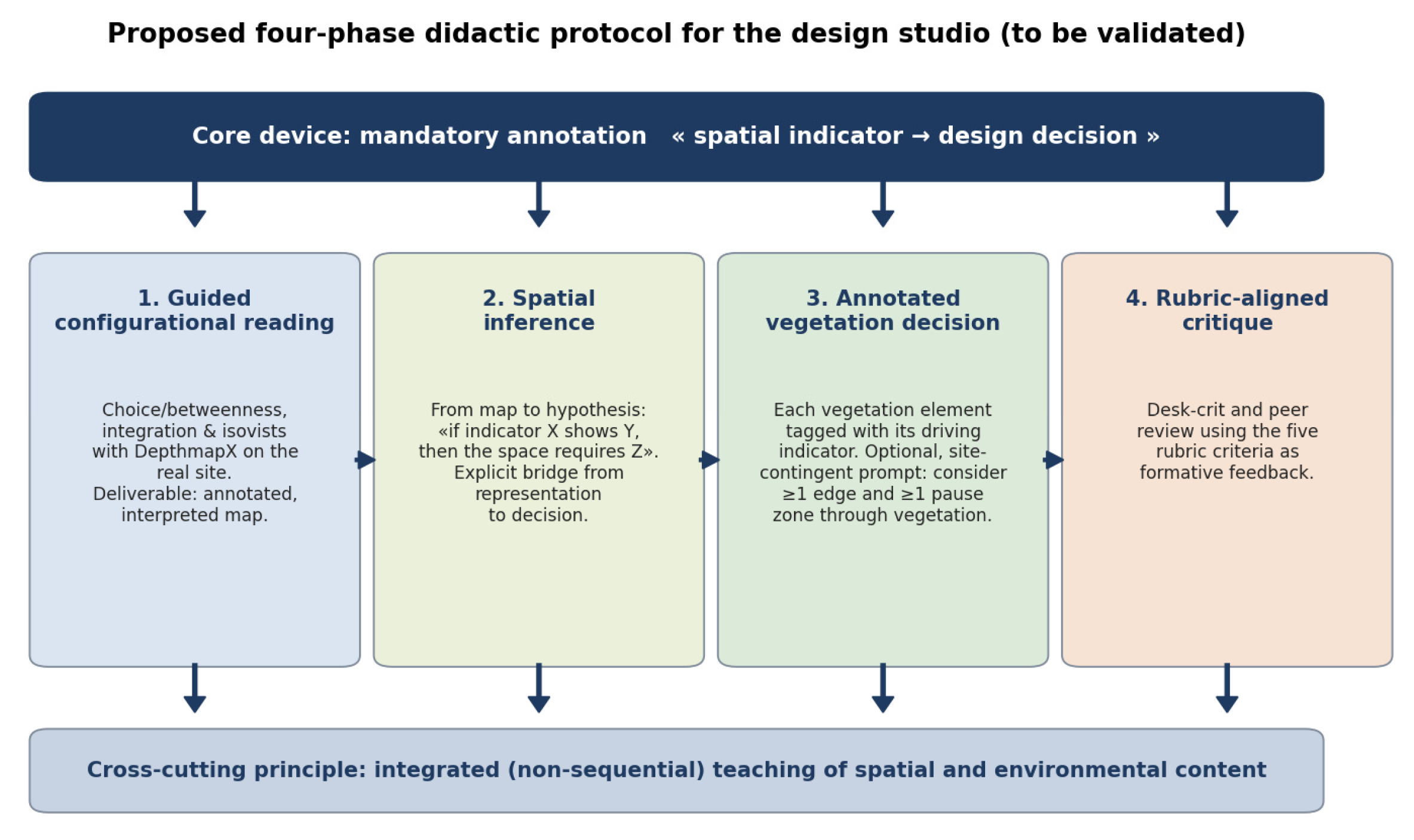
The two identified weaknesses—the superficial operationalization of choice/betweenness and the limited use of vegetation to structure space (defining edges and supporting pauses)—are not isolated faults of the cohort but manifestations of the gap between representation and decision. Building on them, and without having yet been tested in this study, a four-phase didactic sequence for the design studio is proposed, aimed at making that translation explicit and assessable (
Figure 5). Its core device is the mandatory annotation “spatial indicator → design decision”: every design decision represented on the sheet must be tagged with the configurational indicator that motivates it.
The four phases are as follows: (1) guided configurational reading, in which the indicator is introduced and interpreted on the real site (for example, with DepthmapX (version 0.8.0; Space Syntax Laboratory, The Bartlett, University College London (UCL), London, UK)), with an annotated map as deliverable; (2) spatial inference, in which the student formulates hypotheses of the form “if indicator X shows Y, then the space requires Z,” building the explicit bridge between analysis and decision [
45]; (3) annotated vegetation decision, in which each plant mass or element is linked to its motivating indicator and, where the student’s own configurational reading warrants it, the student is prompted—rather than obliged—to consider realizing at least one spatial edge and one pause area through vegetation (this is an optional design prompt directed at the functions found least developed in the present cohort, to be invoked only when the site and the analysis justify it, so that the device makes the edge-and-pause possibility salient without imposing a fixed solution or constraining the student’s creative judgment); and (4) rubric-aligned critique, in which instructor and peer review use the five criteria as formative feedback, so that the rubric operates as a learning tool and not only as a grading device [
44]. As a cross-cutting principle, spatial and environmental content is taught in an integrated, non-sequential manner.
The rationale for each phase follows directly from the difficulties observed in the cohort. Phase 1 is justified because the operationalization gap begins with an insecure reading of the indicators: grounding interpretation on the real site, with an annotated map as a tangible deliverable, gives the subsequent decisions an evidentiary anchor. Phase 2 targets the inferential step that students found most demanding: by requiring an explicit conditional hypothesis linking an indicator to a spatial requirement, it externalizes the reasoning that otherwise remains implicit and converts analysis into a premise for decision. Phase 3 is the point at which evidence becomes form; its core requirement is therefore the annotation tying each element to its motivating indicator, which is what makes the translation visible and assessable. The edge-and-pause element of Phase 3 is deliberately framed as an optional, site-contingent prompt rather than a mandate, precisely to avoid prescribing an outcome that may not suit every site or that could curtail the student’s own spatial proposal; its purpose is to widen the repertoire students consider, not to narrow it. Phase 4 closes the loop by using the same rubric for formative critique, aligning the criteria students are taught with those against which they are judged. Because the protocol is articulated by the indicator-to-decision annotation rather than by any particular planting solution, it is intended to discipline the justification of design moves while leaving the design moves themselves open.
This proposal is presented as an evidence-derived pedagogical hypothesis, not a validated method. Its effectiveness should be tested in subsequent studies through pre–post or comparison-group designs, evaluating whether explicit annotation measurably reduces the gap between representation and decision.
5.2. Validation Agenda and Future Work
The study’s contributions fall into three levels that, in turn, define the future agenda. Methodologically, the study contributes a replicable instrument—a five-criterion analytic rubric coupled with function coding—whose internal consistency proved high (Cronbach’s α = 0.93) and which makes the translation of spatial evidence into landscape decision measurable. Empirically, it precisely locates the learning gap: it is not environmental but spatial–structural, concentrated in the operationalization of choice/betweenness and in the use of vegetation to define edges and support pauses. Projectively, it derives from these findings the four-phase didactic protocol (
Section 5.1). The outstanding step is to test whether that protocol effectively narrows the gap.
To that end, a quasi-experimental validation design with a non-equivalent comparison group is proposed in which the outcome variable is not raw grades—sensitive to the difficulty of each brief—but translation competence, operationalized as the proportion of design decisions carrying an explicit “indicator → decision” annotation, complemented by an appraisal of the depth of that operationalization. The design should maintain a stable, thematically neutral rubric core (the criteria of analysis reading, analysis–decision coherence and justification), pre-register the hypothesis before grading, and incorporate a second coder with reporting of inter-rater agreement (for example, the kappa coefficient), thereby addressing one of the principal limitations of the present work. Such an evaluation design is consistent with recent comparative models that align studio assessment with educational objectives and professional-readiness standards [
54].
The feasibility of this agenda is supported by the fact that the workflow is operable within the regular timeframes of a studio: a single cohort can produce deliverables at different moments of the academic term, offering a baseline for comparison without disrupting teaching dynamics. Moreover, the method is transferable beyond the vegetation theme: the “indicator → decision” device applies equally to bioclimatic indicators (orientation, ventilation, solar exposure, zoning) in a sustainable-housing brief, which would allow the protocol’s robustness to be tested in a different content area. Implementing this agenda will require the corresponding extension of institutional ethics approval.
6. Conclusions
This study examined how intermediate-level architecture students translate space-syntax indicators into strategic vegetation decisions within a minimal sustainable shelter exercise, using an exploratory mixed-methods design applied to fourteen anonymized sheets. The cohort performed generally well (mean = 0.84), with a highly internally consistent rubric (α = 0.93); it approached vegetation predominantly as a functional device—through shade, path guidance and landscape integration—and showed a positive, exploratory association between spatial reading and vegetation reasoning (ρ = 0.61). The principal weakness lay in operationalizing choice/betweenness into specific design decisions and in using vegetation to structure space (defining edges and supporting pauses), confirming a persistent gap between representation and decision.
Returning to the three research questions, the findings answer each in turn. Regarding RQ1 (how students interpret and represent space-syntax indicators), students represented configurational indicators competently overall, but unevenly: movement-based measures (choice/betweenness, local integration) were read more securely than visibility-based ones (visual integration, isovists), and spatial analysis was the lowest-achieving rubric criterion (82.5%), identifying the reading of configurational structure—especially choice/betweenness—as the binding constraint. Regarding RQ2 (how students translate those indicators into strategic vegetation decisions), most students did move from ornament to function—vegetation function reached 84.3% and choice/betweenness governed planting in 12 of 14 sheets—yet the translation was strong for environmental functions (shade, wind, thermal comfort) and weak for the spatial-structuring functions (defining edges, 3/14, and supporting pauses, 8/14), so the indicator-to-decision step succeeded for modifying space but faltered for composing it. Regarding RQ3 (which dimensions reveal the greatest strengths and weaknesses, and what this implies for teaching), graphic clarity was strongest (87.1%) and spatial analysis weakest (87.1% vs. 82.5%, Wilcoxon p = 0.005), a pattern warning that communicative polish can outpace analytical depth and implying that teaching should explicitly scaffold the operationalization of configurational indicators and integrate spatial with environmental reasoning—the implications embodied in the proposed protocol.
The main contributions are methodological and pedagogical, producing a replicable model—an aligned analytic rubric combined with content-analysis coding of vegetation functions—for making visible and assessable the reasoning by which spatial evidence becomes a landscape decision. The approach supports an evidence-based, people-centered and climate-sensitive design education, and offers educators a transparent instrument for fostering sustainable design reasoning in intermediate studios. From the observed patterns, a four-phase didactic protocol for the studio is further derived (
Section 5.1), articulated by the “indicator → decision” annotation, whose testing constitutes a priority line of future work.
For implementation, the protocol reduces to four core moves: (1) read the configurational indicators on the real site and deliver an annotated map; (2) state explicit “if indicator → then spatial requirement” hypotheses; (3) annotate every design element with its motivating indicator, treating the edge-and-pause repertoire as an optional, site-contingent prompt; and (4) use the same five-criterion rubric for formative critique. The sequence can be adjusted to the time available. In a short module (one to two weeks), phases 1–2 can be condensed into a single guided session on a pre-supplied indicator map, phase 3 limited to the annotation requirement on two or three key decisions, and phase 4 run as a brief rubric-based peer review. In a full-term studio, each phase can be developed iteratively across several weeks, the configurational reading extended to multiple indicators and isovists, and phase 4 repeated at successive desk-crits so that the rubric guides revision rather than only final grading. In all variants the non-negotiable element is the indicator-to-decision annotation, which is what carries the learning; the depth of analysis and the number of iterations scale with the available time.
The pedagogical implications are concrete: scaffold the operationalization of configurational indicators, integrate spatial and environmental content, and use the rubric to align outcomes with assessment. The study’s limitations—a small single-section sample, grading and coding by a single analyst (without inter-rater reliability) and a focus on represented behavior—define the future-work agenda. Subsequent studies should expand the sample across sections, sites and climates; establish inter-rater reliability; incorporate measured or simulated microclimatic outcomes to connect represented decisions with environmental performance; and test whether explicit operationalization scaffolds measurably reduce the gap between analysis and decision.
Beyond the immediate case, these findings speak to current directions in sustainable built-environment education and in the teaching of landscape and outdoor space. Recent systematic evidence likewise positions configurational, space-syntax analysis as a route to more sociable, socially sustainable public space [
55]. Accreditation frameworks and disciplinary agendas increasingly ask schools to embed sustainability not as add-on content but as a reasoning competence, and to make that reasoning explicit, assessable and aligned with practice [
41,
42,
43]. The professional turn toward evidence-based and performance-oriented design, and the mainstreaming of nature-based solutions and green infrastructure in urban practice [
11,
12,
34,
56,
57], place a premium on designers who can justify why a given landscape or planting move follows from site evidence rather than from convention. The instrument and protocol proposed here address precisely that demand: by making the “indicator → decision” translation the explicit object of teaching and assessment, they connect studio learning to the way the contemporary profession is expected to argue and document sustainable outdoor design, and they are transferable—beyond vegetation—to bioclimatic and other performance indicators in sustainable-design briefs. In this sense the study’s value is not only pedagogical but also a small contribution to closing the gap between how sustainable design is taught and how it is practiced.