Article

Inventory of Climbing Sites in São Paulo State, Brazil: Integrating Geodiversity Data for Sustainable Adventure Tourism

by
João Paulo Monticelli
1,*,
Maria da Glória Motta Garcia
2,
Gabriella Labate Frugis
2 and
Rogério Pinto Ribeiro
1
1
Department of Geotechnical Engineering, São Carlos School of Engineering EESC, University of São Paulo USP, São Carlos 13566-590, SP, Brazil
2
Institute of Geosciences, University of São Paulo USP, São Paulo 05508-220, SP, Brazil
*
Author to whom correspondence should be addressed.
Sustainability 2025, 17(9), 3900; https://doi.org/10.3390/su17093900
Submission received: 10 March 2025 / Revised: 21 April 2025 / Accepted: 23 April 2025 / Published: 25 April 2025
(This article belongs to the Section Hazards and Sustainability)

Abstract

:
Climbing has gained popularity around the world, particularly since it was added to the 2020 Tokyo Olympic Games. Unlike indoor climbing, outdoor climbing typically takes place in some kind of geological site. This aspect inherently promotes the link to the environment and geoheritage through adventure tourism. Similar documentation, description, and analysis initiatives are sparse in South America, whereas European organizations have employed geoconservation approaches to list and promote climbing sites. Our study addresses a knowledge gap by compiling a list of climbing sites in São Paulo State, Brazil. To assess the geological, sociological, and environmental aspects of the cataloged places, data were acquired using community platforms, guidebooks, and mobile applications. GIS tools were then employed to carry out data treatment and analysis. A dashboard was developed to make the inventory accessible and encourage participation of the scientific and climbing community. The findings underscore locations to apply geoconservation management strategies and draw attention to potential risks associated with outdoor recreational activities. Furthermore, this inventory serves as a valuable foundation for future research integrating geoscience and adventure tourism.

1. Introduction

The sport of climbing can be traced back to the late 18th century, when mountaineering began to gain popularity in Europe as both a recreational activity and a field of study. Over the last century, climbing evolved into various styles, such as alpine climbing, bouldering, traditional climbing, and lead climbing, each requiring different methods, skill levels, and gear. Currently, advances in engineering and the leisure industry have significantly improved climbing safety equipment, contributing to its popularization [1,2].
In recent years, climbing gained special recognition with its inclusion in the Olympic Games at Tokyo 2020, when three categories were introduced, speed climbing, bouldering, and lead climbing, bringing it to a broader audience (Figure 1a). Unlike indoor climbing (as in Olympic Games, usually held in gyms), outdoor climbing is practiced on high-quality rock exposures, i.e., rock outcrops. These outcrops often represent sites of significant geological value, such as sport climbing sites at escarpments (i.e., in São Paulo State, Brazil, Figure 1b), bouldering areas on rockfall deposits (i.e., Yosemite Valley, CA, USA), or on eroded rock blocks (i.e., Fontainebleau, France, Figure 1c). As such, climbing highlights not only physical performance, but also has potential for fostering appreciation of geological heritage, outdoor recreation, adventure tourism, and natural environments.
It is no surprise that many of these climbing sites are considered valuable by the geoheritage community [3,4]. For example, climbing and other outdoor activities, such as hiking and trekking, carried out in geomorphosites (i.e., a geosites valued for their geomorphological elements) have increasingly been recognized and promoted due to their significance for geotourism in small Italian cities [5,6]. According to recent trends within the Italian geoheritage community, such studies have contributed to a framework for assessing these sites and their tourism potential, with a particular emphasis on outdoor activities [7]. These sites may also be considered within the scope of geosystem services, as they provide cultural functions for society, including opportunities for adventure, spiritual and aesthetic experiences, and educational value [3,4].
Currently, several methods have been proposed for selecting and evaluating these sites for geoconservation purposes [8,9,10]. However, some authors have raised concerns about applying these methods to areas that differ from the idealized locations [11]. A new trend is emerging that promotes outdoor recreation areas and adventure tourism activities through geoconservation approaches [12].
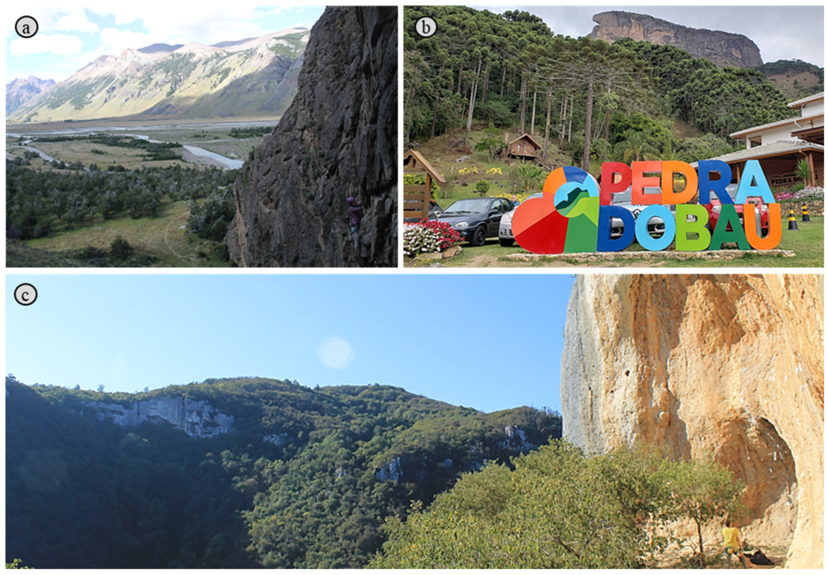
There are numerous sites near small cities in South America that are used for climbing and mountaineering, such as El Chaltén in Argentina (Figure 2a) and São Bento do Sapucaí, São Paulo State, Brazil (Figure 2b). These cities, like many others, rely heavily on the adventure and ecotourism industries. As in some European contexts, these sites have not been systematically inventoried and, thus have not been classified, valued, or promoted using geoconservation methods (Figure 2c). For example, the lithostratigraphic units and lithotypes associated with outdoor recreational activities such as climbing and hiking are likely unfamiliar to much of the geoscientific community in São Paulo State. This knowledge gap likely extends to other regions of Brazil and even internationally.
At the same time, many recreational sites lack clear regulations or guidelines addressing biodiversity and geodiversity for mountaineers and tourists. In contrast, the climbing sites of Lumignano (Figure 2c) have been designated as a Site of Community Importance and covered by the LIFE Colli Berici Natura 2000 project. One of its key focuses is the protection of limestone rock cliffs that support unique vegetation (i.e., semi-natural herbaceous formations and tufa vegetation facies), alongside specific measures to prevent degradation caused by recreational activities such as hiking and climbing [13,14].
Furthermore, it is well known that adventure tourism activities are exposed to geological and geotechnical threats. The lack of information and monitoring can lead to unforeseen risk and site degradation [15,16]. Numerous examples in the literature illustrate these issues, such as the relocation of mountaineer camps due to rockfall risk assessments [17], safety warnings related to anchor failures in low-strength rocks [18,19], and the identification of climbing sectors composed of poor rock mass quality associated with block detachments [20,21,22].
Inventories play a crucial role in geoconservation by providing a structured basis for identifying, classifying, and managing geological sites [23]. Climbing areas, for example, can be classified primarily as geological sites of geomorphological interest, but they may also fall under other frameworks depending on their attributes [24,25]. Their association with specific lithostratigraphic units highlights how geological history and rock characteristics influence regional and local geodiversity expression. Inventories may also provide guidance on use and protection, which can be particularly valuable for territorial planning. Moreover, they can help identify areas exposed to geological and geotechnical risks [17,26], including those on low-strength rocks used for adventure tourism [18,19].
In this context, our study represents a pioneering effort in assessing where adventure tourism activities such as climbing are emerging, and establishing a foundational understanding of spatial distribution and land-use implications. An inventory of climbing sites was developed based on extensive data collection from online climbing communities, websites, books, guides, and mobile applications. This task was performed for the first time in São Paulo State, Brazil. The geological, geographic, social, and environmental attributes were extracted from each climbing site using a geographical information system. Data were treated and analyzed in ArcGIS® (https://www.arcgis.com/) and Excel® tools for the graphical presentation and scientific dissemination. The resulting inventory offers a baseline for future qualitative and quantitative assessments based on geoconservation methods. It also documents the locations of outdoor recreational areas where land use intersects with geosciences and adventure tourism, and where geological and geotechnical threats may require active management.

2. Study Area

2.1. Administration Division

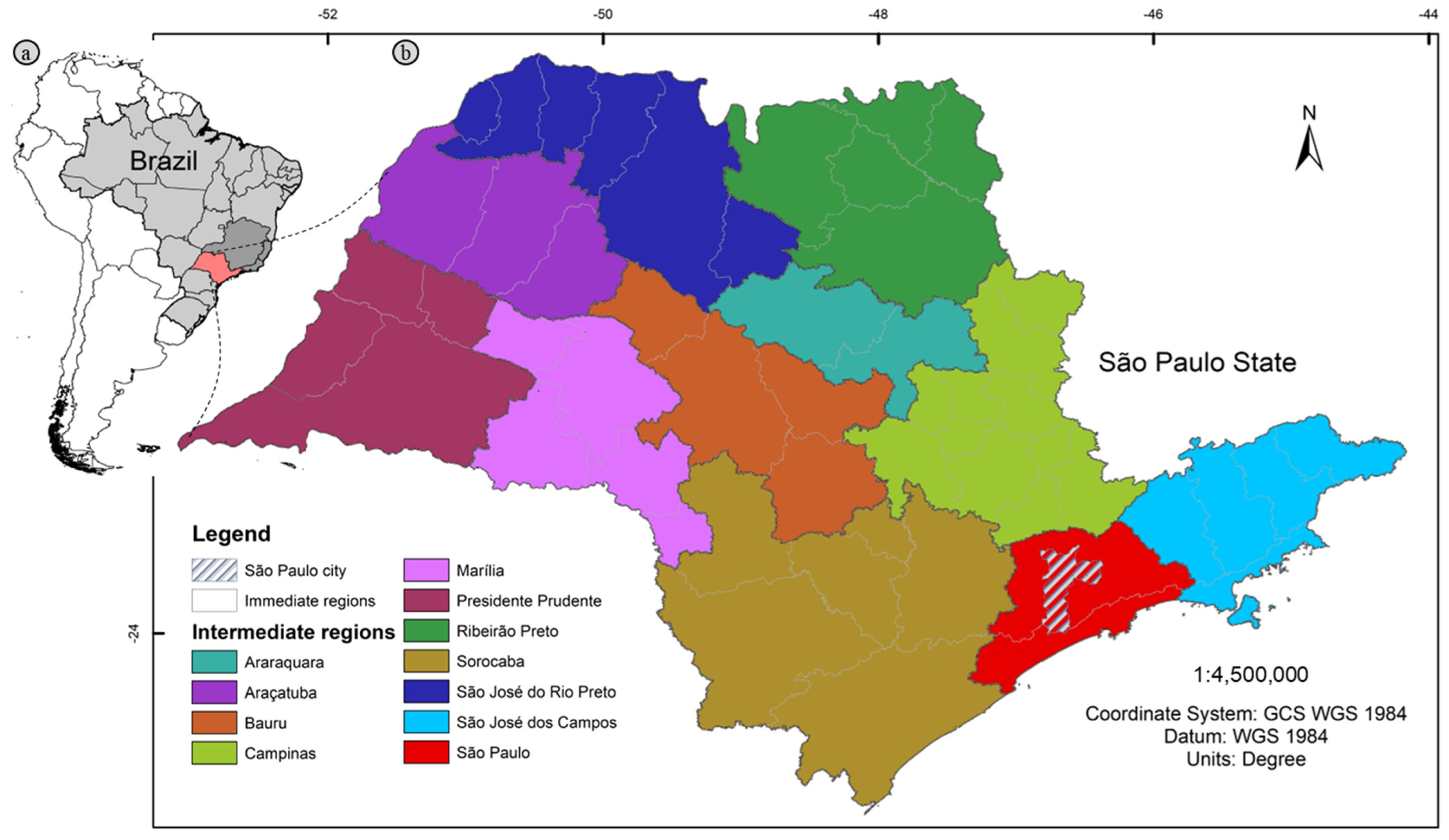
The State of São Paulo, located in southeast Brazil, is the country’s most populous, with approximately 46 million people—22% of Brazil’s population (Figure A1a). Figure A1, Figure A2, Figure A3 and Figure A4 are presented in the Appendix A.
São Paulo leads the national economy, contributing nearly one-third of Brazil’s GDP, with key sectors such as industry, agribusiness, and finance. The capital, São Paulo city, is South America’s largest urban center, with over 12 million residents, and serves as an economic and cultural hub. The state’s multicultural population reflects a history of immigration and internal migration.
São Paulo is also recognized for its advanced transport network, which includes roads, railways, and major ports like Santos—the largest in Latin America. This infrastructure, combined with the state’s strategic location, boosts economic integration and attracts investment. According to the Brazilian Institute of Geography and Statistics, São Paulo is divided into intermediate and immediate geographic regions, supplementing its municipal structure [27] (Figure A1b).

2.2. Biomes, Protected Areas, and Climate

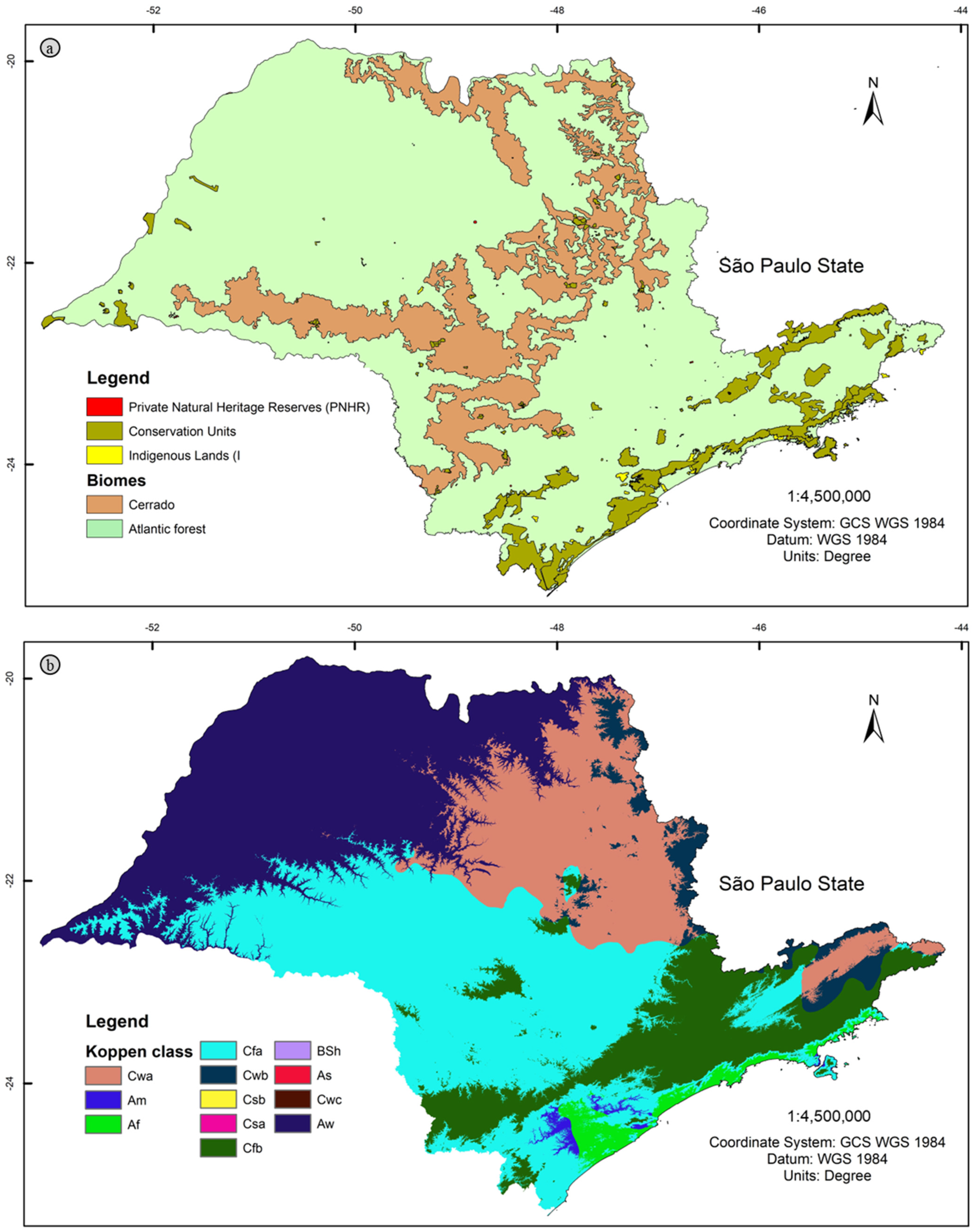
São Paulo State encompasses a mosaic of tropical rainforests and savannas, primarily the Atlantic Forest (Mata Atlântica) and Cerrado biomes [28] (Figure A2a). The Atlantic Forest is known for its high biodiversity and ecosystem services, including medicinal and ornamental plants. The Cerrado, a tropical savanna, is dominated by small trees, shrubs, and grasslands adapted to drought conditions. Urbanization and agriculture have caused significant deforestation in both biomes [29], with remaining forests mostly confined to protected areas, including parks, reserves, and indigenous lands.
To safeguard biodiversity, the state has established protected areas like Alto Ribeira and Serra do Mar Parks, which conserve fragments of the Atlantic Mountain rainforest vital for endangered species like the jaguar (Panthera onca) [30]. In addition, there are private, indigenous, and quilombos-protected lands in São Paulo State (Figure A2a). However, none of these protected areas currently include mapped or designated climbing sites for tourism, highlighting the need for a systematic inventory for environmental management. Although tourism is encouraged, climbing sites are not yet officially recognized (https://smastr16.blob.core.windows.net/guiadeaps/2021/08/apresentacao-novos-roteiros.pdf (accessed on 9 March 2025)).
Climbing sites located in the Atlantic Forest and Cerrado biomes of the State typically experience a tropical climate with warm, rainy summers and dry, mild winters [31]. Climate varies by altitude, latitude, and proximity to the sea, categorized into humid tropical, highland tropical, and subtropical. According to the Köppen classification, São Paulo encompasses seven climate regions, including tropical with dry winter (Aw) in the northwest and humid subtropical with dry winter (Cwa and Cwb) in the northeast (Figure A2b) [32].

2.3. Geological and Geomorphological Aspects

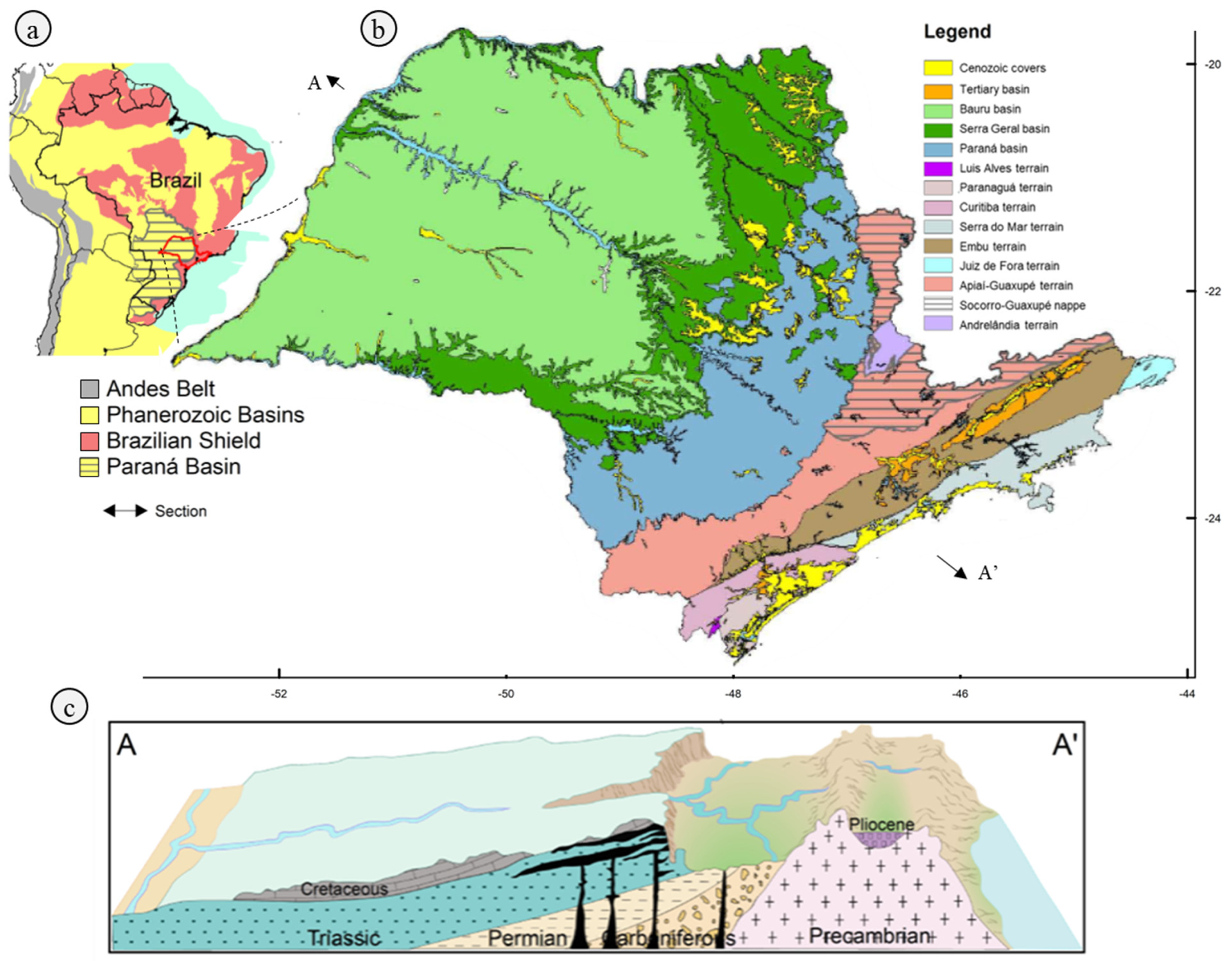
São Paulo State spans two major geological units: the Paraná Basin and the Brazilian Shield, encompassing Phanerozoic volcano-sedimentary sequences and Precambrian to Cambrian rocks from orogenic belts (Figure A3a). The Brazilian Shield, dominated by crystalline rocks, is linked to the Pan African-Brazilian tectonic cycle, covering the Archean to Neoproterozoic periods [33,34]. The Mantiqueira Province, the main orogen belt in São Paulo, is divided into terranes and lithostratigraphic domains, often bordered by shear zones. These structural trends control granitic genesis from magmatic arcs and post-collisional periods [35]. The province covers 30% of the state [36], with igneous and metamorphic rocks like diorites, gabbro, syenites, granites, schists, gneiss, migmatites, and quartzites [37].
The Paraná Basin, an intracratonic basin, covers 70% of São Paulo and extends across 1.6 million km2 (Figure A3b). It comprises six supersequences deposited from the Carboniferous to Cretaceous periods, recording glacial, marine, and continental environments. The Gondwana III sequence includes volcanic activity linked to the breakup of the supercontinent, as recorded in the Serra Geral Formation, a globally-recognized Large Igneous Province [38]. The basin features sedimentary rocks like diamictites, limestones, shales, and sandstones, as well as volcanic rocks like basalt and diabase.
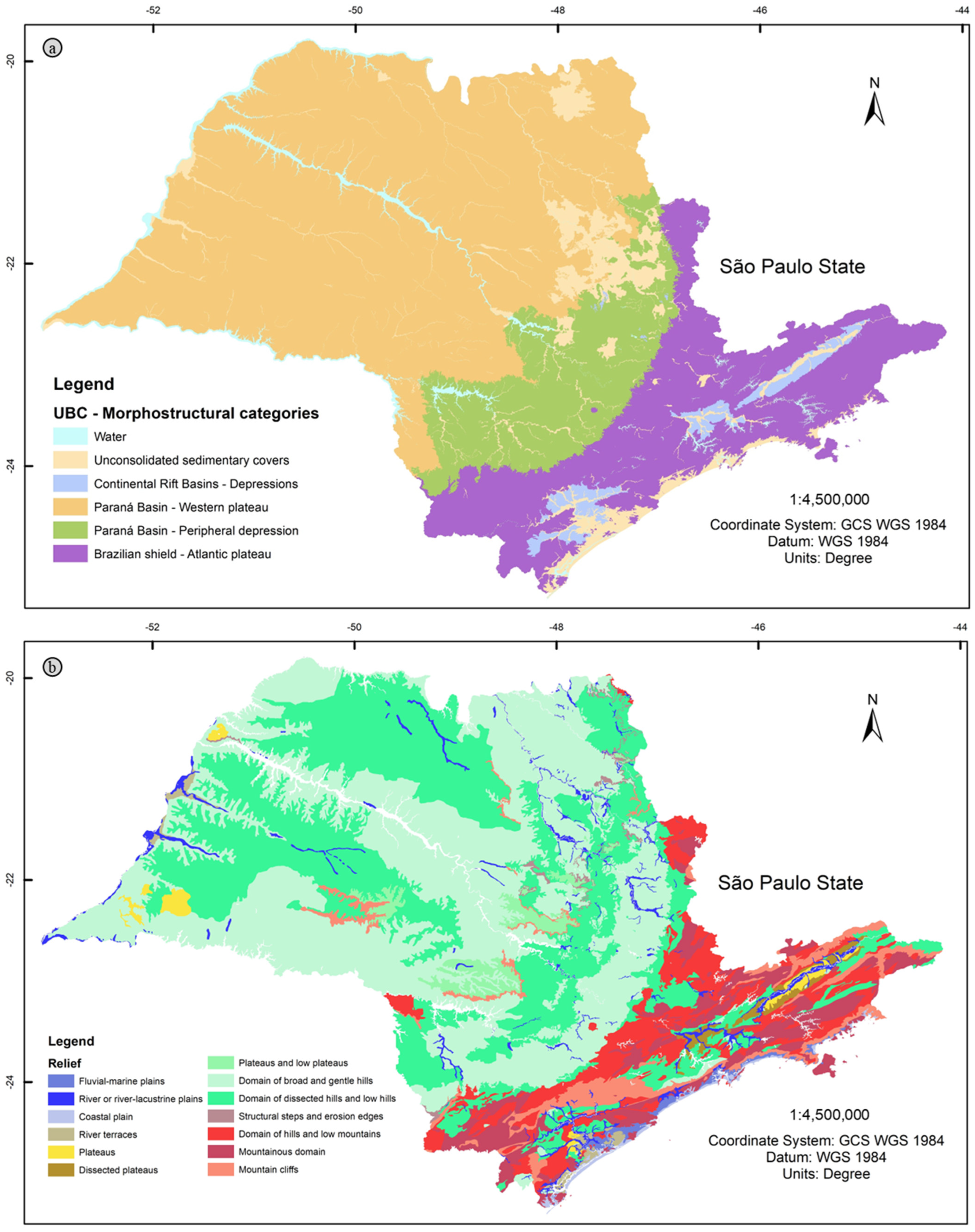
Late Mesozoic and Cenozoic continental and coastal rift basins, such as the Taubaté, São Paulo, and Santos basins, overlie the crystalline rocks [39]. These basins are aligned to coastal depressions and mountain ranges like the Serra do Mar and Mantiqueira (Figure A4).
The relief of São Paulo has been shaped by tectonic events from the Pan African-Brazilian cycle, the Mesozoic breakup of Gondwana, and Cenozoic reactivation [33,34,40]. The interplay between the Paraná Basin and the Brazilian Shield has produced a unique landscape, classified into five geomorphological provinces: unconsolidated sedimentary covers, continental rift basins, western plateau, peripheral depression, and Atlantic plateau [41] (Figure A4a). The state’s terrain includes dissected hills, low mountain ranges, and escarpments, such as the Cuesta [42] (Figure A3c and Figure A4b). Notably, this geological and geomorphological framework supports both conventional and adventure tourism, with geodiversity offering a wide range of geological attractions for outdoor enthusiasts [38,43].

3. Materials and Methods

The inventory of climbing sites was structured into five key steps, each outlined below:
(I)
Defining the study area. The study focuses on locations within São Paulo State, although some climbing sites in other Brazilian states, like Rio de Janeiro, Minas Gerais, Espírito Santo, and Bahia, were also cataloged.
(II)
Establishing research sources and site criteria. This step involved gathering information about climbing sites within the study area. Unlike traditional geoscientific approaches that rely on academic sources, this step drew upon our experience as amateur climbers. We sought information from non-traditional sources, such as websites, low-circulation books, brochures, and the feedback from visitors and stakeholders involved in managing tourism attractions, an approach often referred to as specialist consulting in geoconservation methods [25].
Information was collected from climbing communities, websites, books, guides, and mobile applications. The database includes sources like the books by experienced climbers like Moraes and Izzo, Chinaglia, and Frechou, representing areas such as São José dos Campos, São Carlos, and São Bento do Sapucaí. Route maps (sketches) available on Brazilian climbing websites were also considered [44,45].
Global climbing apps, such as theCrag and MyProject, were essential for identifying the location and current status of sites. A key criterion was that each climbing site must have a defined spatial reference and a reasonable number of routes (crags). Notable community engagement—such as comments on websites, shared photos, and achievements logged in apps—was used as indicators of ongoing site usage. Locations formally listed in books and guides or informally on route maps typically provide essential details, such as access points, ownership, and route descriptions. The inventory excludes sites still under development, where the infrastructure is being built.
(III)
Collecting environmental and geoscientific data. This step involved collecting geological, geomorphological, and environmental information using topographic maps, satellite images, publicly available scientific literature, and online data [27,28,29,30,31,41]. Terrain information was extracted for each location using the 30 m resolution Copernicus digital elevation model from the European Space Agency [46]. Using GIS tools, detailed thematic maps were created to provide clear spatial visualization of soil and lithotypes, geomorphological features, elevation, environmental conditions, and political boundaries such as protected areas (parks, quilombos, and indigenous lands).
(IV)
Analyzing the data. Once the climbing and environmental data were organized, we began to analyze the relationships among them. Graphical presentations were used to interpret the data, for example, to determine whether climbing sites were artificial (e.g., quarries) or natural outcrops, the relief patterns, and the types of rocks used for anchor installation. Information on soil erosion, site degradation, and geological and geotechnical threats was also assessed to establish a panorama of climbing sites across São Paulo State.
(V)
Disseminating the results. The final step was the creation of a comprehensive and reliable database of climbing sites, designed for use in geosciences and related disciplines. The inventory includes a detailed report, maps, and tables in digital format, integrated into geospatial platforms for easy access, dissemination, and future updates. A dashboard was developed, with access provided in the Supplementary Materials (Table S1: inventory; Table S2: dashboard).

4. Results

A total of 148 climbing sites were mapped (Figure A5), with their locations and graphical relationships available in Supplementary Materials. As previously noted, approximately 15 sites were excluded due to incomplete infrastructure, such as trail access, routes, and anchor systems still under development.

4.1. Characteristics of Administrative Division

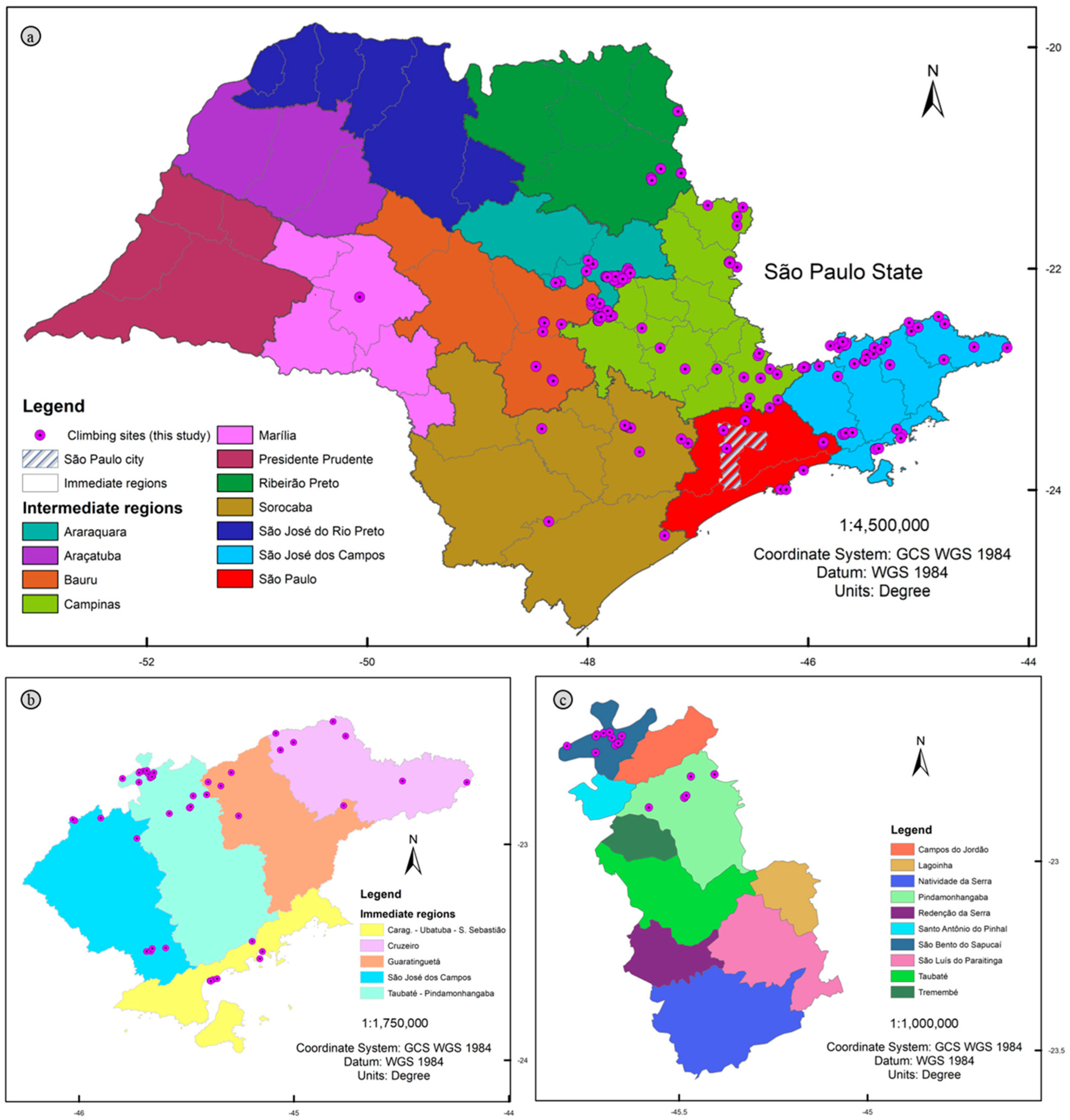
A mountaineer or climber could visit a different climbing site every two days during the year in state of São Paulo. Out of the 645 municipalities, only 60 have climbing sites, representing just 9.3%. This aspect is also reflected in the representation of intermediate and immediate regions (Figure 3a).
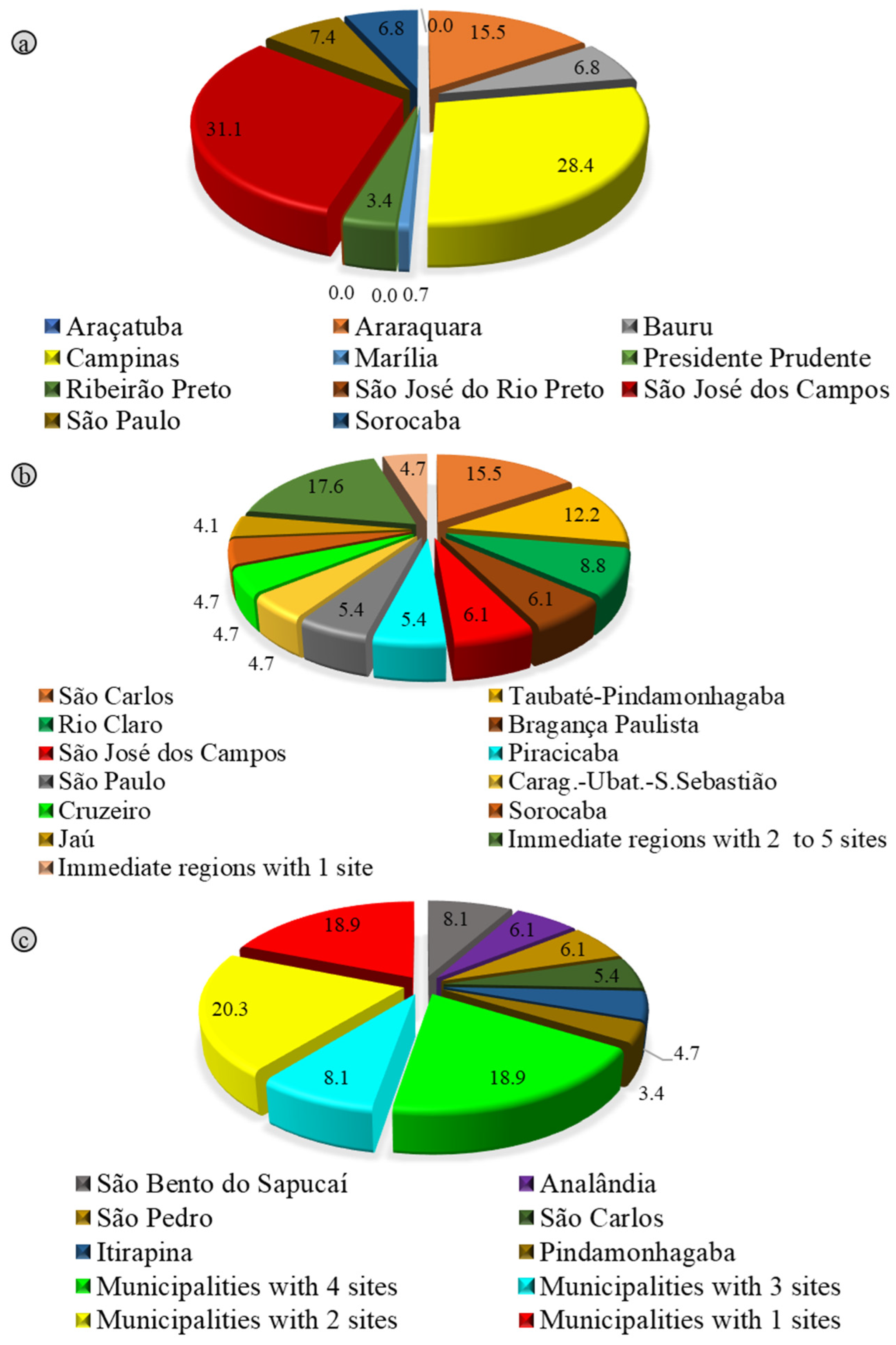
The main intermediate region is associated with São José dos Campos, which accounts for 31.1% of the climbing sites of São Paulo State, followed by the Campinas region with 28.4% and Araraquara with 15.5%. Other intermediate regions have less than 10% of the number of climbing sites (Figure 4a).
The São José dos Campos region is composed of five immediate regions (Figure 3b). Notably, the Taubaté-Pindamonhangaba immediate region includes the municipalities of Pindamonhangaba and São Bento do Sapucaí. The latter is home to 12 climbing sites within its territory—the largest number among all municipalities in the state (Figure 3c). In parallel, around 38% of municipalities have between one and three climbing sites (Figure 4c).
Regarding immediate regions, those with two to five sites represent 18%, while others, such as Jaú, Sorocaba, Cruzeiro, Caraguatatuba-Ubatuba-São Sebastião, São Paulo, and Piracicaba, which have six or more sites, are highlighted in the graphs. The São Carlos region stands out with 23 climbing sites, accounting for 15.5% of the total in São Paulo State, followed by Taubaté-Pindamonhangaba with 12.2% and the Rio Claro region with 8.8%. Other intermediate regions host fewer than 6.5% of the number of the sites (Figure 4b).
The São Carlos immediate region comprises seven municipalities, with São Carlos and Itirapina together comprising 60% of its climbing sites. All related information and relationships can be explored in Table S2: dashboard.

4.2. Biomes, Protected Areas, and Climate Characteristics

Of the 148 sites identified, 60% are located within the Atlantic Forest biome, while 40% are associated with the Cerrado biome. When preserved, these biomes can be easily distinguished by their forest characteristics found in climbing sectors (Figure 5a,b) and their trail accesses (Figure 5c,d).
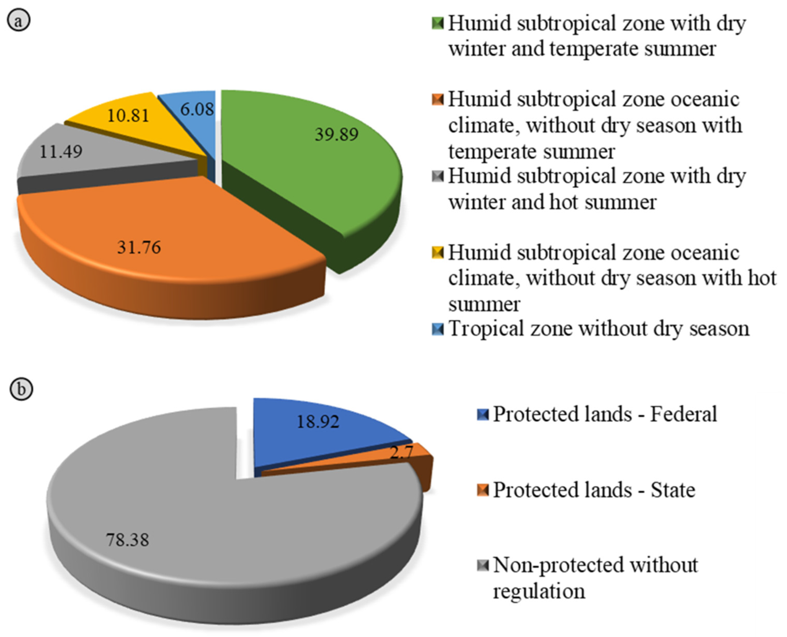
Regarding climate, 93.9% of the sites are associated with the humid subtropical zone, while 6.1% are associated with the tropical zone. The tropical zone with dry winter and temperate summer dominated over 39,8% of climbing sites in São Paulo State, while the tropical zone with oceanic climate without dry season with temperate summer dominated over 31.7% of locations (Figure 6a). Put simply, climbers in São Paulo State are likely to encounter hot and rainy conditions, depending on the season.
Notably, 32 climbing sites are located within some type of protected land, representing around 20% of São Paulo State. On the other hand, around 80% of climbing sites fall outside any formally designated environmental protection area. Broadly speaking, this may result in a lack of management plans related to outdoor activities at some sites. This is truly worth highlighting, since climbing—like other activities—requires special attention regarding impacts on species such as vegetation, bees, primates, and birds, due to contact in climbing sectors or on trail accesses. In this case, we can barely say that visitation at the remaining 118 locations follows any environmental protocols or restrictions, i.e., environmental management plans.
In parallel, 19% and 3% of climbing sites are under federally and state-administered protected areas, respectively (Figure 6b). These include state parks, ecological stations, and reserve areas. Another notable point is that around 23 climbing sites are located within areas associated with mining activity, including licensed areas, research authorizations, applications, and mining concessions. All of the information can be easily consulted in Table S2: dashboard.

4.3. Geological and Geomorphological Characteristics

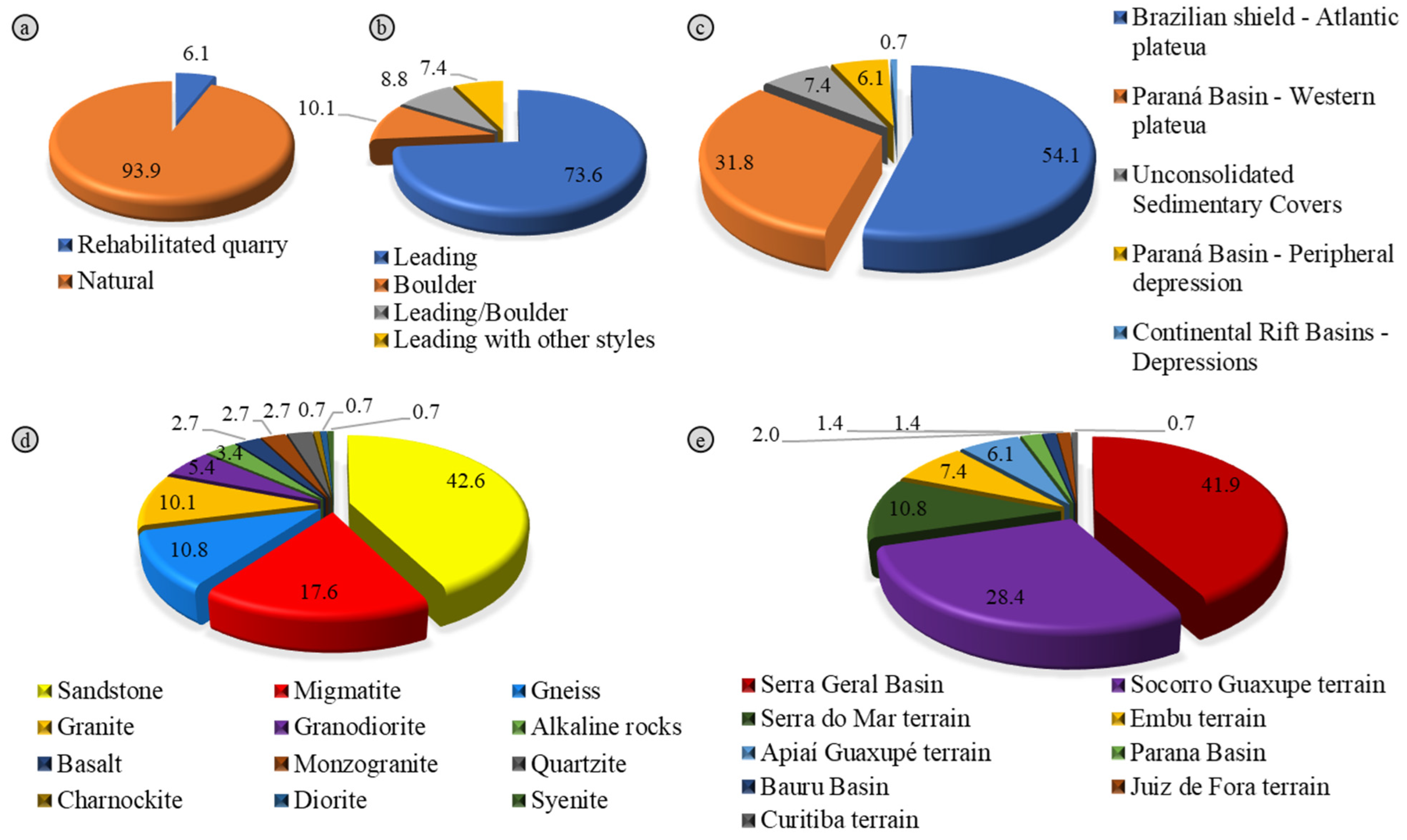
Mountaineers in São Paulo State can access two types of climbing sites: natural rock outcrops and man-made sites, such as rehabilitated quarries. These account for 94% and 6% of the climbing sites, respectively (Figure 7a).
Natural sites accommodate a range of climbing styles, including lead climbing, bouldering, traditional climbing, and via ferrata. In contrast, rehabilitated quarries are predominantly used for lead climbing, with all recorded sites supporting this style (Table S2: dashboard).
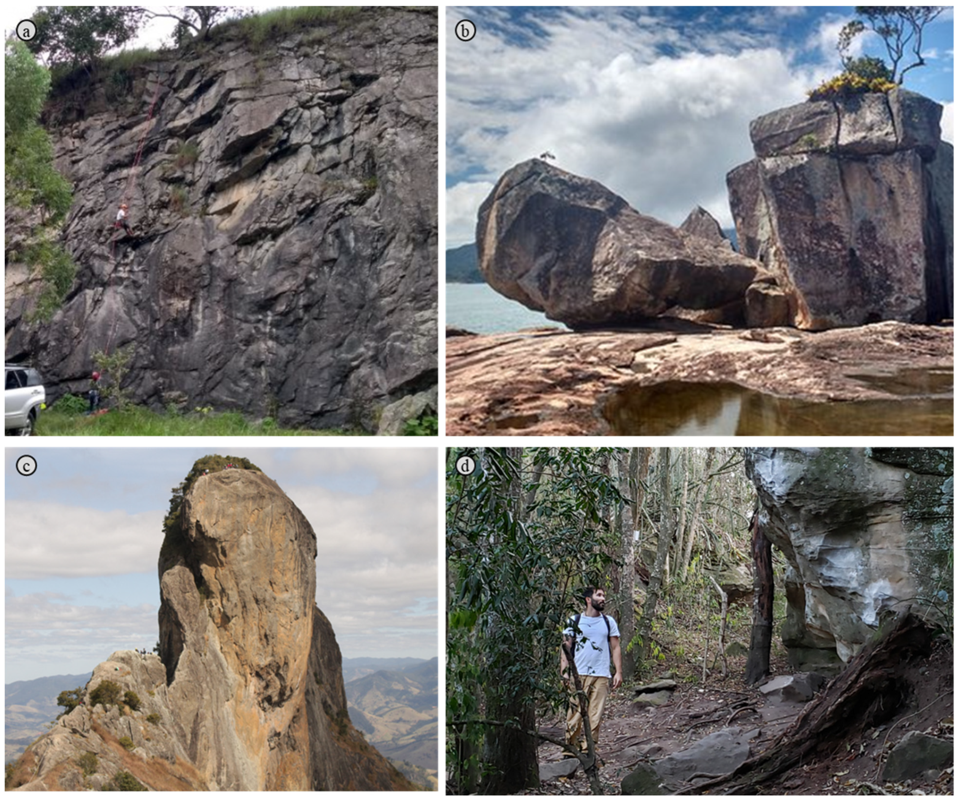
In these quarries, geomorphological features are generally observed only along access routes, as pit depressions limit horizontal visibility during climbing (Figure 8a). These areas typically consist of low hills and ridges, and the main lithostratigraphic unit is related to the Serra Geral Formation, characterized by basalt rocks (Figure 7d,e).
Beyond quarry settings, most natural climbing sites in the inventory are located in the Atlantic Plateau and Western Plateau geomorphological provinces, representing 54% and 32%, respectively (Figure 7c). These areas are usually associated with escarpments and mountainous terrain (Figure 8c). Other provinces and geomorphological patterns account for less than 10% of the sites (Figure 7c).
According to the geological map of São Paulo State [41], the main lithotypes in recreational use are sandstones, representing approximately 40% of the rocks at climbing sites (Figure 7d). These are followed by migmatitic and gneissic rocks with 27% and granitic and granodioritic rocks (15%). In terms of tectonostratigraphic units, the Serra Geral Basin accounts for 40% of sites, followed by 28% within the Socorro-Guaxupé Nappe. The Serra do Mar and Embu terranes together represent 20% of climbing sites (Figure 7e).

4.4. Environmental Degradation and Social Risks

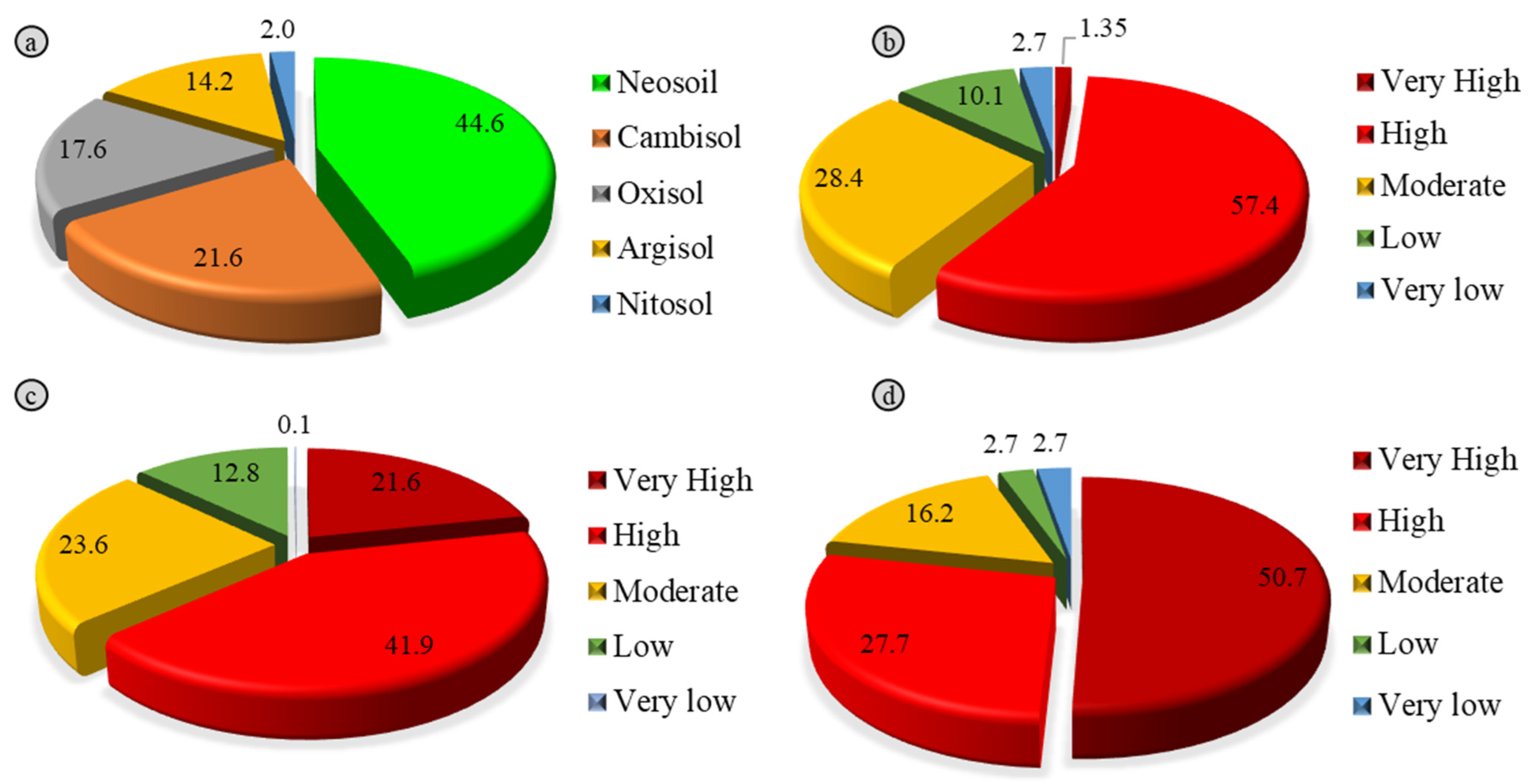
The main soil types of climbing sites are Neosols (44.4%), followed by Cambisols (21.6%) and Oxisols (17.5%) (Figure 9). These soil types are key to managing trails between parking areas and climbing sectors. Notably, 57.4% of climbing sites are located in areas of high-erosion-susceptibility, and 28.4% in moderate-susceptibility areas. Less than 5% of sites fall within very low or very high erosion susceptibility classes (Figure 9b). Filtering the dashboard results reveals patterns: Neosols dominate high-susceptibility zones, while Cambisols are prevalent in moderate-susceptibility areas.
Interestingly, around 50% of climbing sites are situated in areas classified as having very high degradation susceptibility (Figure 9d), partly due to nearby land uses such as agriculture, industry, and highways. High degradation areas account for 27.7%, while less than 18% of sites are in zones with moderate to low degradation.
Regarding individual and social risks, primary geological and geotechnical threats are associated with rockfalls and related failure mechanisms, including toppling, planar, and wedge failures.
Approximately 60% of climbing sites are located in areas of very high to high rockfall susceptibility (Figure 9c and Figure 10). Very high susceptibility areas are concentrated within the Brazilian Shield, while zones of high to moderate susceptibility are distributed across the state of São Paulo. The São José dos Campos region has the greatest number of sites in very high susceptibility areas, while the Campinas region leads in the high susceptibility category (Table S2: dashboard).

5. Discussion

This section presents the integration of geodiversity data and the environmental context of climbing sites in the state of São Paulo. Many of these sites feature distinctive geological and geomorphological characteristics that enhance their potential for nature-based tourism. Nevertheless, a considerable number of sites lie outside protected areas and lack environmental management, revealing a significant gap between recreational use and conservation strategies. Furthermore, many sites are situated within areas under the control of the mining industry, making them particularly susceptible to degradation.

5.1. Physical Environment and Socio-Spatial Vulnerabilities

Regarding characteristics of administrative division, it is noteworthy that many climbing sites are located in municipalities that promote ecotourism or contain areas with strong environmental appeal, supporting nature-based recreational activities such as hiking and mountaineering. These characteristics often align with classifications granted by the São Paulo State government, including Estâncias Turísticas and Estâncias Climáticas, which highlight destinations with natural and cultural value for tourism [47]. Notable examples include the municipality of Analândia, home to the iconic Morro do Cuscuzeiro; São Bento do Sapucaí, which hosts climbing routes at the Pedra do Baú Natural Monument; and Itirapina, known for its sandstone formations and distinct ruiniform landscape.
Nevertheless, in many of these municipalities (e.g., Pindamonhangaba, Iperó, São Carlos), climbing is still not formally included in adventure tourism strategies. For further information, please consult the official websites of these municipalities. The lack of planning focused on geodiversity-based activities represents a missed opportunity for integrated and sustainable (geo)tourism development [48,49,50]. It is worth noting that municipalities with only one to three climbing sites account for approximately 45% of the dataset, indicating widespread but underutilized climbing potential across the state.
These areas frequently lack structured tourism policies or environmental planning initiatives that acknowledge climbing as a relevant activity. This underscores the need to incorporate it into broader tourism and conservation agendas, particularly in municipalities that already hold significant natural assets, but have yet to formalize their recreational use [51,52].
In addition to the political-administrative division, the climbing sites inventory also incorporated key environmental variables such as biomes, climate patterns, and the distribution of protected areas. These elements are essential for understanding the broader spatial dynamics that influence the development and conservation of climbing sites. Nevertheless, there is currently no formal recognition or mapping of climbing sites within these protected lands for tourism purposes in São Paulo State [47]. This gap reflects a broader lack of integration between outdoor activities and conservation strategies in many Brazilian protected areas. In contrast, some European projects offer a successful example of how climbing sites can be officially inventoried and managed within environmentally sensitive areas, such as the Lumignano climbing site (Figure 2c) [14].
Through collaborative planning, zoning, and the implementation of sustainable visitation guidelines, this example demonstrates that outdoor recreation and nature conservation are not mutually exclusive. Several studies support this approach [25,49,50,53,54], contributing to a growing body of knowledge. Adopting similar frameworks in Brazil could significantly enhance the management of climbing sites, ensuring the protection of geoheritage and biodiversity while promoting responsible (geo)tourism.
Building on this, another critical environmental factor is climate, which directly interacts with the dynamics of nature-based attractions. Accidents, like the well-known rescue at Pico do Marins in 2022 [55], could be prevented by defining appropriate visitation periods and weather conditions, particularly in high mountain environments.
Another notable point is that around 23 climbing sites are located within areas associated with mining activity, including licensed areas, research authorizations, applications, and mining concessions. These are sites at risk of being abruptly closed by the mining industry, with little regard for their geoheritage and biodiversity elements. A striking example is the Dib climbing site, a decommissioned quarry located in the São Paulo metropolitan area, which was once considered for conversion into a landfill. This case highlights the lack of integrated land use planning that considers both environmental value and recreational potential.
This gap becomes more evident when contrasted with successful spatial planning cases elsewhere, such as the rehabilitated Ópera do Arame quarry in Curitiba, Paraná. São Paulo State lacks similar spatial planning initiatives. As a result, loose rock and rock block detachments are common in decommissioned quarries (Figure 8a). At the same time, locals and mountaineering communities often carry out risk mitigation practices (i.e., removal of unstable rock blocks) in both abandoned quarries and natural sites. While practical expertise may develop over time, unsupervised interventions without the oversight of engineering geologists may result in accidents or even fatalities [56].
Observations indicate that several risk factors remain beyond the control of park managers, mountaineering organizations, and government authorities. Nevertheless, some old quarries, such as Dib and Jardim Garcia [21], have been rehabilitated by the mountaineering community. Although further studies are required, these efforts demonstrate how the sport can contribute to sustainable development and ESG principles, especially in the context of post-mining land use.
The climbing sites exhibit significant altitudinal variation, ranging from 1.5 m above sea level, as seen in sites like Canto do Ishigami and Praia da Fortaleza, to nearly 1700 m at Pedra do Baú (Figure 8b,c). These variations underscore the variety of landscape elements and scenic vistas shaped by geomorphological factors. Such features can be classified using geoconservation methods aimed at geotourism [5,6,9]. In addition to influencing user experience, our findings underscore the significant role of sandstones in the development of climbing sites across São Paulo State (Figure 7). Lithotypes and their mineralogical properties, such as composition and grain size, are known influence climber preferences, as these characteristics directly influence the duration and experience of climbing activities. Smooth rocks like sandstone and limestone are generally preferred over granite-gneissic rocks [8]. For example, fine-grained rocks are less abrasive on handholds than coarse-grained rocks, as demonstrated by a comparison between the bouldering sites in Iperó (Figure 8d), composed of sandstone, and Praia da Fortaleza (Figure 8b), made up of granite-gneissic rocks. Furthermore, mineralogical characteristics significantly influence the physical and mechanical properties of rocks, thereby affecting the installation and load capacity of rock anchors [18,19], which are critical for climber safety [57]. It is well known that fine-grained gneissic rocks are stronger than coarse-grained ones, and that water content influences rock strength depending on the degree of weathering [58,59]. There have been numerous reports of climbers breaking holds after rainy days, as observed in Iperó (Figure 8d). These geotechnical aspects highlight the importance of careful planning to ensure the preservation, long-term usability of climbing sites, and user safety, similar to European counterparts such as the Lumignano climbing site.
Climbing, trekking, and mountaineering, together with their associated infrastructure, require geological and geotechnical investigations for effective management and sustainable use. Essential information includes soil and rock characteristics, environmental variables, and susceptibility maps (e.g., shallow landslides, rockfalls, etc.). Outdoor recreational areas used for adventure tourism activities like climbing represent a specific form of land use. Consequently, these areas may be prone to soil degradation and individual and social risks, like those found in urban areas or along highways, ranging from stationary to non-stationary elements at risk [60] (Figure 9 and Figure 10). It is important to emphasize that some of the sites were visited. The above statements were therefore verified; however, many locations require further investigation, including (i) field inspections to validate the aforementioned findings (Figure 10); (ii) detailed rockfall risk assessments, e.g., Ref. [17]; (iii) characterization of rock–anchor strength interactions to support best practice protocols, e.g., Refs. [18,19]; and (iv) stability analysis to identify climbing sectors prone to block detachments, i.e., Refs. [20,21,22]. We consider such studies essential for ensuring both safety and sustainability in public and concession-managed parks, as well as on private lands.
Moreover, conducting such assessments aligns with Brazil’s National Policy for Protection and Civil Defense (Law No. 12.608/2012) [61], which highlights the importance of disaster risk prevention and mitigation through technical studies, continuous monitoring, and integrated territorial planning. Therefore, incorporating geodiversity data and geotechnical evaluations in adventure (geo)tourism areas is not only a safety measure, but also a legal and ethical responsibility shared by both public and private stakeholders [62,63]. This is especially relevant given the rising demand for nature-based tourism and the increasing influence of climate change on slope stability [49].

5.2. Implications for Sustainable Development

The climbing site inventory in the State of São Paulo provides a strategic foundation for integrating land use planning, geoconservation, geotourism, and geoethics—key pillars for promoting sustainable territorial development. The mapped distribution of 148 climbing sites reflects the interplay between geodiversity, accessibility, recreational use, and environmental vulnerability. This dataset supports a critical analysis of both opportunities and challenges for incorporating climbing into broader agendas related to sustainable tourism, environmental education, and conservation policies [47,52,64].
The spatial concentration of climbing sites in the intermediate regions of São José dos Campos (31.1%), Campinas (28.4%), and Araraquara (15.5%) reflects the combined influence of active local communities and favorable geological conditions. Around 45% of municipalities have only one to three mapped climbing sites, suggesting latent potential for local development. Municipalities such as São Bento do Sapucaí, officially designated as Municipalities of Tourist Interest (MITs) and integrated into established tourism circuits such as Rota Mantiqueira [47] (São Paulo, 2023), emerge as key hubs with promising conditions for structured geotourism initiatives aligned with conservation efforts. Other regions, such as Piracicaba, Jaú, Sorocaba, and Cruzeiro, host between two and six sites each and are located in areas of notable natural and cultural value. These municipalities are often included in the state’s Tourism Routes Programme and benefit from MIT or Tourist Resort status, granting them access to governance mechanisms and financial resources to support sustainable tourism development.
Underexplored territories with scenic and geological appeal could benefit from targeted inventories, strategic partnerships with local tourism councils, and the integration of climbing into broader tourism and land management strategies. In this context, geotourism acts as a transversal axis, connecting climbing activities to geoscientific interpretation, visitor experience, and geoconservation [48,49,65].
Given that nearly 80% of climbing sites are located outside protected areas, there is a critical need for planning tools that effectively combine recreational use with conservation. Geoconservation approaches provide practical frameworks for the inventory, classification, and monitoring of climbing areas, especially when aligned with the promotion of cultural ecosystem services and integrated territorial management strategies [25,66,67]. These approaches are also consistent with IUCN recommendations for integrating geodiversity and geoheritage into land use and visitor management [68,69]. Moreover, the overlap of 23 climbing sites with active or prospective mining areas highlights the urgency of inclusive governance strategies that balance conservation, recreation, and resource extraction.
Geoethics offers a crucial perspective for guiding decision-making in the use and management of climbing landscapes. It focuses on the ethical responsibilities of individuals, communities, and the scientific sector in the responsible stewardship of natural systems, particularly in vulnerable or under-regulated settings. Many climbing sites in the State of São Paulo lie outside formal regulatory frameworks or face conflicts arising from overlapping land uses, reinforcing the need for shared governance models grounded in geoethical principles. As highlighted by Peppoloni and Di Capua [62,63] and further supported by Stewart and Gill [54], geoscientists play a central role in advancing responsible practices, particularly through engagement with environmental policy and educational outreach. Nevertheless, they remain underrepresented in broader sustainability discourses [54]. Increasing their involvement can enhance the contribution of climbing areas to ethical, inclusive, and sustainable territorial development. Furthermore, climbing landscapes deliver important cultural ecosystem services and illustrate how social geology can foster science–society dialogue and promote community-based land stewardship [70].
When responsibly managed and integrated into strategic frameworks, climbing sites can function as active interfaces between society and geodiversity. They support multiple Sustainable Development Goals, notably education (SDG 4), sustainable tourism (SDG 8), resilient infrastructure (SDG 9), and environmental conservation (SDG 15), reinforcing their role in inclusive and sustainable development.

6. Conclusions

This study explores adventure tourism through a comprehensive inventory of climbing sites in São Paulo State, southeast Brazil. The inventory was built using diverse sources from the climbing community, obtained from websites, books, guides, and mobile applications, and structured with GIS tools. Data were analyzed using worksheets and dashboards to enable accessibility and ease of distribution. The main findings are summarized as follows:
  • Climbing sites in São Paulo State exhibit a combination of geological, geomorphological, and environmental features. Natural sites outnumber rehabilitated quarries and exhibit greater geodiversity, reinforcing their potential as geoheritage. On the other side, rehabilitated quarries exemplify how climbing communities can contribute to sustainable initiatives aligned with ESG principles.
  • The intermediate region of São José dos Campos and the immediate region of São Carlos host a significant number of climbing sites, with São Bento do Sapucaí standing out among municipalities. While some climbing sites fall under environmental administration, several are located on private lands outside protected areas. The majority of sites are situated within the Atlantic Plateau geomorphological province, where access trails predominantly traverse Neosols and Cambisols. Rock outcrops used for recreational activities like climbing mainly consist of Botucatu Formation sandstones and, secondarily, the Socorro-Guaxupé terrane migmatites.
  • Key challenges include soil degradation, rockfall susceptibility, and rock strength. A considerable number of climbing sites are in areas of high to very high susceptibility and degradation risk. In some cases, the rock may also present uncertain strength due to weathering. This highlights the need for detailed field inspections and geological and geotechnical studies addressing erosion control, risk assessments, and the interaction between rocks and climbing anchors.
  • A collaborative approach is essential for the sustainable use and management of climbing sites, involving local and regional government authorities, park managers, and private stakeholders, alongside mountaineering organizations and the scientific community.
This inventory marks the first attempt to establish a free-access database of climbing sites in São Paulo State (Table S1: inventory). While it is not definitive, it provides a valuable overview of where outdoor recreational activities such as climbing take place and highlights key fundamental environmental characteristics associated with this type of land use. It also serves as a crucial resource for applying geoconservation strategies and underscores the need for detailed geological and geotechnical investigations to promote sustainable land use.
The inventory primarily focuses on geological and risk-related aspects. Future research could expand this approach by incorporating ecological, social, and economic dimensions, as well as a more in-depth assessment of environmental degradation. Additionally, detailed studies on how geodiversity elements at multiple scales shape key characteristics that affect the climbing experience—and the potential of these sites to provide geosystem services—represent an important area for further exploration. Moreover, qualitative and quantitative assessments using geoheritage approaches can support the identification of sites with significant scientific, touristic, and educational value, providing useful information for decision-makers and promoting sustainable land use.
The findings presented here contribute to a broader understanding of the relationship between climbing activities, geodiversity, and land use. By making these data accessible, this study supports informed decision-making by policymakers, land managers, and climbers, encouraging practices that enhance both environmental conservation and recreational opportunities. While inaccuracies may exist, feedback, suggestions, and corrections are encouraged via the contact information provided, in order to improve and expand this inventory further.

Supplementary Materials

The following supporting information can be downloaded at https://www.mdpi.com/article/10.3390/su17093900/s1, Table S1: inventory; Table S2: dashboard.

Author Contributions

Conceptualization, methodology, software and formal analysis, validation, writing—original draft preparation, writing—review and editing, J.P.M.; review, M.d.G.M.G., G.L.F. and R.P.R.; supervision, R.P.R. All authors have read and agreed to the published version of the manuscript.

Funding

This research received no external funding.

Institutional Review Board Statement

Not applicable.

Informed Consent Statement

Not applicable.

Data Availability Statement

The original data presented in the study are openly available at https://www.mdpi.com/article/10.3390/su17093900/s1.

Acknowledgments

We thank the São Carlos School of Engineering, University of São Paulo, for supporting the development of this research. Special thanks to the climbing communities of São Carlos, São Paulo, and São Bento do Sapucaí for their valuable insights and engagement. We are also grateful to the fourth anonymous reviewer for their thoughtful and constructive comments, which significantly contributed to improving the clarity and quality of this manuscript.

Conflicts of Interest

The authors declare no conflicts of interest.

Appendix A

Figure A1. Study site: (a) location map in South America and (b) São Paulo State intermediate geographic regions. Immediate regions are indicated in grey lines.
Sustainability 17 03900 g0a1
Figure A2. Study site: (a) biomes, conservation units, and indigenous lands [26], and (b) Koppen–Geiger climate classification [27].
Sustainability 17 03900 g0a2
Figure A3. Study site: (a) Paraná Basin in South America, (b) geological map [34], (c) geological and geomorphological cross-section of São Paulo State. Modified from Ref. [42].
Sustainability 17 03900 g0a3
Figure A4. Study site: geomorphological domains according to (a) morpho-structural and (b) second-order categories [34].
Sustainability 17 03900 g0a4
Figure A5. The inventory of climbing sites from São Paulo State.
Sustainability 17 03900 g0a5

References

  1. Smith, R.A. The Development of Equipment to Reduce Risk in Rock Climbing. Sports Eng. 1998, 1, 27–39. [Google Scholar] [CrossRef]
  2. Long, J.; Gaines, B. Climbing Anchors; Rowman & Littlefield: Lanham, MD, USA, 2013; ISBN 978-1-4930-0133-0. [Google Scholar]
  3. Bollati, I.; Zucali, M.; Giovenco, C.; Pelfini, M. Geoheritage and Sport Climbing Activities: Using the Montestrutto Cliff (Austroalpine Domain, Western Alps) as an Example of Scientific and Educational Representativeness. Ital. J. Geosci. 2014, 133, 187–199. [Google Scholar] [CrossRef]
  4. Knight, J.; Bollati, I.M. Rock Climbing Sites as Locations for Geoheritage and Geoscience Engagement in Mountains. Geol. Today 2024, 40, 223–227. [Google Scholar] [CrossRef]
  5. Panizza, M. Geomorphosites: Concepts, Methods and Examples of Geomorphological Survey. Chin. Sci. Bull. 2001, 46, 4–5. [Google Scholar] [CrossRef]
  6. Panizza, V.; Mennella, M. Assessing Geomorphosites Used for Rock Climbing: The Example of Monteleone Rocca Doria (Sardinia, Italy). Geogr. Helv. 2007, 62, 181–191. [Google Scholar] [CrossRef]
  7. Bollati, I.; Coratza, P.; Giardino, M.; Laureti, L.; Leonelli, G.; Panizza, M.; Panizza, V.; Pelfini, M.; Piacente, S.; Pica, A.; et al. Directions in Geoheritage Studies: Suggestions from the Italian Geomorphological Community. In Proceedings of the Engineering Geology for Society and Territory—Volume 8; Lollino, G., Giordan, D., Marunteanu, C., Christaras, B., Yoshinori, I., Margottini, C., Eds.; Springer International Publishing: Cham, Switzerland, 2015; pp. 213–217. [Google Scholar]
  8. Biancotti, A.; Motta, L.; Motta, M. Valutazione della potenzialità d’uso turistico-sportivo di beni paesaggistici: Un esempio d’applicazione ai siti d’arrampicata sportiva. In Proceedings of the II Colloquio Int. “Turismo, Ambiente e Parchi Naturali”, Sharm-el-Sheikh, Egypt, 2–9 June 2001. [Google Scholar]
  9. Bollati, I.; Fossati, M.; Zanoletti, E.; Zucali, M.; Magagna, A.; Pelfini, M. A Methodological Proposal for the Assessment of Cliffs Equipped for Climbing as a Component of Geoheritage and Tools for Earth Science Education: The Case of the Verbano-Cusio-Ossola (Western Italian Alps). J. Virtual Explor. 2016, 49, 23. [Google Scholar]
  10. Bollati, I.; Coratza, P.; Panizza, V.; Pelfini, M. Lithological and Structural Control on Italian Mountain Geoheritage: Opportunities for Tourism, Outdoor and Educational Activities. Quaest. Geogr. 2018, 37, 53–73. [Google Scholar] [CrossRef]
  11. Ruban, D.A.; Ermolaev, V.A. Unique Geology and Climbing: A Literature Review. Geosciences 2020, 10, 259. [Google Scholar] [CrossRef]
  12. Bollati, I.M.; Masseroli, A.; Al Kindi, M.; Cezar, L.; Chrobak-Žuffová, A.; Dongre, A.; Fassoulas, C.; Fazio, E.; Garcia-Rodríguez, M.; Knight, J.; et al. The IGCP 714 Project “3GEO—Geoclimbing & Geotrekking in Geoparks”—Selection of Geodiversity Sites Equipped for Climbing for Combining Outdoor and Multimedia Activities. Geoheritage 2024, 16, 79. [Google Scholar] [CrossRef]
  13. CAI Vicenza—Lumignano Classica Regulation. Available online: https://www.caivicenza.it/index.php/ginnastica-e-palestre/admin/69-lumignano-classica-regolamento (accessed on 1 April 2025).
  14. LIFE 3.0—LIFE Project Public Page. Available online: https://webgate.ec.europa.eu/life/publicWebsite/project/LIFE08-NAT-IT-000362/conservation-actions-habitat-and-species-improvement-and-preservation-of-sic-colli-berici-nature-reserve (accessed on 8 April 2025).
  15. Haegeli, P.; Pröbstl-Haider, U. Research on Personal Risk in Outdoor Recreation and Nature-Based Tourism. J. Outdoor Recreat. Tour. 2016, 13, 1–9. [Google Scholar] [CrossRef]
  16. Mata, C.; Pereira, C.; Carvalhinho, L. Safety Measures and Risk Analysis for Outdoor Recreation Technicians and Practitioners: A Systematic Review. Sustainability 2022, 14, 3332. [Google Scholar] [CrossRef]
  17. Stock, G.M.; Luco, N.; Collins, B.D.; Harp, E.L.; Reichenbach, P.; Frankel, K.L. Quantitative Rock-Fall Hazard and Risk Assessment for Yosemite Valley, Yosemite National Park, California; U.S. Geological Survey: Reston, VA, USA, 2014. [Google Scholar]
  18. Joffrey Hyman, A.J. Soft Sandstone Rock Anchor Testing at Swinburne. Available online: https://www.climbing.co.za/bolting-information/soft-sandstone-rock-anchor-testing-at-swinburne/ (accessed on 8 March 2025).
  19. Law, M.; Hawkshaw, S. Testing of Rock Climbing Anchors in Weak Sandstone. Sports Eng. 2015, 18, 21–28. [Google Scholar] [CrossRef]
  20. Motta, M.; Panizza, V.; Pecci, M. Geomorphological Hazard Assessment on Natural Rock Wall for Free Climbing Practice. Mem. Descr. Della Carta Geol. D’italia 2009, 87, 109–122. [Google Scholar]
  21. Viana, C.D.; Garcia, G.P.B.; Grohmann, C.H.; Albuquerque, R.W.; Monticelli, J.P.; Cacciari, P.P.; Futai, M.M. Slope Stability Assessment Based on a Digital Outcrop Model: A Case-Study at Jardim Garcia Quarry. In Proceedings of the 14th ISRM Congress, Foz do Iguaçu, Brazil, 13–18 September 2019. [Google Scholar]
  22. Beni, T.; Gigli, G.; Lombardi, L.; Carlà, T.; Casagli, N. Route Stability Index (RSI): An Index for the Assessment of Rockfall-Related Hazards in Rock Slopes Equipped for Sport Climbing. Geoheritage 2022, 14, 80. [Google Scholar] [CrossRef]
  23. García-Cortés, A.; Carcavilla, L.; Díaz-Martínez, E.; Vegas, J. Documento Metodológico Para La Elaboración Del Inventario Español de Lugares de Interés Geológico (IELIG); Instituto Geológico y Minero de España (IGME): Madrid, Spain, 2009. [Google Scholar]
  24. Santos, P.L.A.; Brilha, J. A Review on Tourism Carrying Capacity Assessment and a Proposal for Its Application on Geological Sites. Geoheritage 2023, 15, 47. [Google Scholar] [CrossRef]
  25. Brilha, J. Inventory and Quantitative Assessment of Geosites and Geodiversity Sites: A Review. Geoheritage 2016, 8, 119–134. [Google Scholar] [CrossRef]
  26. Guzzetti, F. Landslide Hazard and Risk Assessment. Ph.D. Thesis, Universitäts- und Landesbibliothek Bonn, Bonn, Germany, 2006. [Google Scholar]
  27. Divisão Regional | IBGE. Available online: https://www.ibge.gov.br/geociencias/organizacao-do-territorio/divisao-regional.html (accessed on 9 March 2025).
  28. Conti, J.B.; Furlan, S.A. Geoecologia: O Clima, Os Solos e a Biota. In Geografia do Brasil; Edusp: São Paulo, Brazil, 1996. [Google Scholar]
  29. Souza, C.M.; Shimbo, J.Z.; Rosa, M.R.; Parente, L.L.; Alencar, A.A.; Rudorff, B.F.T.; Hasenack, H.; Matsumoto, M.G.; Ferreira, L.; Souza-Filho, P.W.M.; et al. Reconstructing Three Decades of Land Use and Land Cover Changes in Brazilian Biomes with Landsat Archive and Earth Engine. Remote Sens. 2020, 12, 2735. [Google Scholar] [CrossRef]
  30. DataGEO—Sistema Ambiental Paulista. Available online: http://datageo.ambiente.sp.gov.br/ (accessed on 9 March 2025).
  31. Alvares, C.A.; Stape, J.L.; Sentelhas, P.C.; De Moraes Gonçalves, J.L.; Sparovek, G. Köppen’s Climate Classification Map for Brazil. Meteorol. Z. 2013, 22, 711–728. [Google Scholar] [CrossRef]
  32. Novais, G.T.; Galvani, E. Uma tipologia de classificação climática aplicada ao estado de São Paulo. Rev. Dep. Geogr. 2022, 42, e184630. [Google Scholar] [CrossRef]
  33. Heilbron, M.; Valeriano, C.M.; Tassinari, C.C.G.; Almeida, J.; Tupinambá, M.; Siga, O., Jr.; Trouw, R. Correlation of Neoproterozoic Terranes between the Ribeira Belt, SE Brazil and Its African Counterpart: Comparative Tectonic Evolution and Open Questions. In West Gondwana: Pre-Cenozoic Correlations Across the South Atlantic Region; Pankhurst, R.J., Trouw, R.A.J., Neves, B.B.d.B., de Wit, M.J., Eds.; The Geological Society of London: London, UK, 2008; Volume 294, ISBN 978-1-86239-247-2. [Google Scholar]
  34. de Brito Neves, B.B.; Fuck, R.A. Neoproterozoic Evolution of the Basement of the South-American Platform. J. S. Am. Earth Sci. 2013, 47, 72–89. [Google Scholar] [CrossRef]
  35. Campanha, G.A.D.C.; Sadowski, G.R. Tectonics of the Southern Portion of the Ribeira Belt (Apiaí Domain). Precambrian Res. 1999, 98, 31–51. [Google Scholar] [CrossRef]
  36. Janasi, V.D.A.; Alves, A.; Vlach, S.R.F.; Leite, R.J. Granitos peraluminosos da porção central da Faixa Ribeira, Estado de São Paulo: Sucessivos eventos de reciclagem da crosta continental no neoproterozóico. Geol. USP Sér. cient. 2003, 3, 13–24. [Google Scholar] [CrossRef]
  37. Meira, V.T. Evolução Tectono-Metamórfica Neoproterozoica dos Complexos Embu e Costeiro no Contexto de Formação do Gondwana Ocidental (Leste do Estado de São Paulo). Ph.D. Thesis, Universidade de São Paulo: São Paulo, Brazil, 2015. [Google Scholar]
  38. Garcia, M.d.G.M.; Brilha, J.; de Lima, F.F.; Vargas, J.C.; Pérez-Aguilar, A.; Alves, A.; Campanha, G.A.d.C.; Duleba, W.; Faleiros, F.M.; Fernandes, L.A.; et al. The Inventory of Geological Heritage of the State of São Paulo, Brazil: Methodological Basis, Results and Perspectives. Geoheritage 2018, 10, 239–258. [Google Scholar] [CrossRef]
  39. Riccomini, C.; Peloggia, A.U.G.; Saloni, J.C.L.; Kohnke, M.W.; Figueira, R.M. Neotectonic Activity in the Serra Do Mar Rift System (Southeastern Brazil). J. S. Am. Earth Sci. 1989, 2, 191–197. [Google Scholar] [CrossRef]
  40. Hasui, Y. Neotectonics and Fundamental Aspects of Resurgent Tectonics in Brazil. In Proceedings of the Neotectonics and Cenozoic Continental Sedimentation in Southeastern Brazil Workshop, São Paulo, Brazil, 1990; pp. 1–31. [Google Scholar]
  41. Perrotta, M.M.; Salvador, E.D.; Lopes, R.D.C.; D’Agostino, L.Z.; Peruffo, N.; Gomes, S.D.; Sachs, L.L.B.; Meira, V.T.; Garcia, M.D.G.M.; Lacerda Filho, J.V. Mapa Geológico Do Estado de São Paulo, Escala 1: 750.000; Programa Geologia do Brasil–PGB, CPRM: São Paulo, Brazil, 2005. [Google Scholar]
  42. Ross, J.L.S. Geografia Do Brasil; EDUSP: São Paulo, Brazil, 2005; Volume 3. [Google Scholar]
  43. Mantesso-Neto, V.; Ribeiro, R.R.; Garcia, M.G.M.; Del Lama, E.A.; Theodorovicz, A. Patrimônio geológico no estado de São Paulo. Bol. Parana. Geociências 2013, 70, 53–76. [Google Scholar] [CrossRef]
  44. CBME—Confederação Brasileira de Montanhismo e Escalada. Available online: https://cbme.org.br/novo/ (accessed on 9 March 2025).
  45. Escaladas.com.br. Available online: https://www.escaladas.com.br/ (accessed on 9 March 2025).
  46. Homepage | Copernicus. Available online: https://www.copernicus.eu/en (accessed on 9 March 2025).
  47. Secretaria de Turismo e Viagens. ROTAS TURÍSTICAS. Available online: https://www.turismo.sp.gov.br:443/acoes-e-programas-rotas-turisticas (accessed on 9 April 2025).
  48. Dowling, R.; Newsome, D. Handbook of Geotourism; Edward Elgar Publishing: Cheltenham, UK, 2018. [Google Scholar]
  49. Hose, T.A. 3G’s for Modern Geotourism. Geoheritage 2012, 4, 7–24. [Google Scholar] [CrossRef]
  50. Reynard, E.; Buckingham, T.; Martin, S.; Regolini, G. Geoheritage, Geoconservation and Geotourism in Switzerland. In Landscapes and Landforms of Switzerland; Reynard, E., Ed.; Springer International Publishing: Cham, Switzerland, 2021; pp. 411–425. ISBN 978-3-030-43203-4. [Google Scholar]
  51. Secretaria de Turismo e Viagens do Estado de São Paulo. Available online: https://www.turismo.sp.gov.br/municipiosturisticos (accessed on 9 April 2025).
  52. Machado, R.M.; Hanashiro, W.S.; Barreto, O.F.G.; de Almeida, V.A.A. Políticas Públicas De Apoio Ao Desenvolvimento Dos Municípios Turísticos Do Estado De São Paulo. Rev. Jurídica OAB Tatuapé 2023, 2. [Google Scholar]
  53. Gordon, J.E.; Crofts, R.; Díaz-Martínez, E.; Woo, K.S. Enhancing the Role of Geoconservation in Protected Area Management and Nature Conservation. Geoheritage 2018, 10, 191–203. [Google Scholar] [CrossRef]
  54. Stewart, I.S.; Gill, J.C. Social Geology—Integrating Sustainability Concepts into Earth Sciences. Proc. Geol. Assoc. 2017, 128, 165–172. [Google Scholar] [CrossRef]
  55. “Colocou Pessoas Sob Risco de Morte”, Diz Bombeiro Sobre Coach Que Organizou Trilha No Pico Dos Marins | Vale Do Paraíba e Região | G1. Available online: https://g1.globo.com/sp/vale-do-paraiba-regiao/noticia/2022/01/07/colocou-pessoas-sob-risco-de-morte-diz-bombeiro-sobre-coach-que-organizou-trilha-no-pico-dos-marins.ghtml (accessed on 9 March 2025).
  56. Correio Braziliense Pedra se Solta e Mata Estudante Durante Escalada. Available online: https://www.correiobraziliense.com.br/brasil/2021/11/4960302-pedra-se-solta-e-mata-estudante-durante-escalada.html (accessed on 9 March 2025).
  57. UIAA 123:2020; Rock Anchors: Climbing and Mountaineering Equipment. UIAA: Bern, Switzerland, 2020.
  58. Marques, E.A.G.; Barroso, E.V.; Menezes Filho, A.P.; Vargas, E.d.A. Weathering Zones on Metamorphic Rocks from Rio de Janeiro—Physical, Mineralogical and Geomechanical Characterization. Eng. Geol. 2010, 111, 1–18. [Google Scholar] [CrossRef]
  59. Monticelli, J.P.; Ribeiro, R.; Futai, M. Relationship between Durability Index and Uniaxial Compressive Strength of a Gneissic Rock at Different Weathering Grades. Bull. Eng. Geol. Environ. 2020, 79, 1381–1397. [Google Scholar] [CrossRef]
  60. Fell, R.; Ho, K.K.S.; Leroi, S.L.; Leroi, E. A Framework for Landslide Risk Assessment and Management. In Landslide Risk Management; CRC Press: Florida, FL, USA, 2005; ISBN 978-0-429-15135-4. [Google Scholar]
  61. Política Nacional de Proteção e Defesa Civil—PNPDEC. Available online: https://www.planalto.gov.br/ccivil_03/_ato2011-2014/2012/lei/l12608.htm (accessed on 9 April 2025).
  62. Peppoloni, S.; Capua, G.D. Geoethics: Manifesto for an Ethics of Responsibility Towards the Earth; Springer Nature: Berlin, Germany, 2022; ISBN 978-3-030-98044-3. [Google Scholar]
  63. Peppoloni, S.; Capua, G.D. Geoethics: The Role and Responsibility of Geoscientists; Geological Society of London: London, UK, 2015; ISBN 978-1-86239-726-2. [Google Scholar]
  64. Secretaria de Turismo e Viagens. Plano Turismo SP 2030. Available online: https://www.turismo.sp.gov.br/plano20-30 (accessed on 9 April 2025).
  65. Gordon, J.E. Geoheritage, Geotourism and the Cultural Landscape: Enhancing the Visitor Experience and Promoting Geoconservation. Geosciences 2018, 8, 136. [Google Scholar] [CrossRef]
  66. Henriques, M.H.; dos Reis, R.P.; Brilha, J.; Mota, T. Geoconservation as an Emerging Geoscience. Geoheritage 2011, 3, 117–128. [Google Scholar] [CrossRef]
  67. Reynard, E.; Brilha, J. Geoheritage: Assessment, Protection, and Management; Elsevier: Philadelphia, PA, USA, 2017; ISBN 978-0-12-809542-3. [Google Scholar]
  68. Crofts, R.; Gordon, J.E.; Brilha, J.B.; Gray, M.; Gunn, J.; Larwood, J.; Santucci, V.L.; Tormey, D.; Worboys, G.L. Guidelines for Geoconservation in Protected and Conserved Areas; International Union for Conservation of Nature (IUCN): Gland, Switzerland, 2020; ISBN 978-2-8317-2079-1. [Google Scholar]
  69. Brilha, J.; Monge-Ganuzas, M.; Woo, K.S.; Casadevall, T.; Migoń, P.; Gunn, J.; Erikstad, L.; Page, K.; Da, M.; Garcia, G.; et al. Key Geoheritage Areas Scoping Study and Guidelines; WCPA: Gland, Switzerland, 2025. [Google Scholar] [CrossRef]
  70. Gray, M.; Gordon, J.E.; Brown, E.J. Geodiversity and the Ecosystem Approach: The Contribution of Geoscience in Delivering Integrated Environmental Management. Proc. Geol. Assoc. 2013, 124, 659–673. [Google Scholar] [CrossRef]
Figure 1. Climbing sport examples: (a) indoor climbing (speed climbing) and outdoor climbing, (b) sportive climbing, and (c) bouldering. Photographic records: (a) Olympic media collection, (b) first author, and (c) local climbing book.
Sustainability 17 03900 g001
Figure 2. Photographic records of climbing sites: (a) valley in Patagonia (El Chaltén, Argentina); (b) the base of Pedra do Baú (São Bento do Sapucaí, Brazil); and (c) Lumignano site (Italy) (photographic records: first author).
Sustainability 17 03900 g002
Figure 3. Characteristics of administrative division: (a) intermediate regions, (b) main intermediate region of São José dos Campos highlighting its immediate regions, and (c) Taubaté-Pindamonhangaba immediate region, showing in detail the municipalities of São Bento do Sapucaí and Pindamonhangaba.
Sustainability 17 03900 g003
Figure 4. Administration division characteristics: (a) intermediate, (b) immediate regions, and (c) municipalities.
Sustainability 17 03900 g004
Figure 5. Biomes presented in climbing sites and their trails accesses: (a,b) Atlantic Forest and (c,d) Cerrado (savanna) (photographic records: first author).
Sustainability 17 03900 g005
Figure 6. Inventory representation related to (a) climate and (b) protected land characteristics.
Sustainability 17 03900 g006
Figure 7. Climbing sites geological and geomorphological characteristics: (a) kind of sites, (b) climbing styles, (c) geomorphological province, (d) lithotype, and (e) lithostratigraphic unit.
Sustainability 17 03900 g007
Figure 8. Photographic records of some climbing sites in São Paulo State: (a) Marmeleiro quarry, (b) Praia da Fortaleza, (c) Pedra do Baú, and (d) Iperó (photographic records: first author).
Sustainability 17 03900 g008
Figure 9. Degradation and social risk aspects presented in the dataset. Examples of susceptibility mapping: (a) soil type, (b) erosion, (c) rockfall, and (d) degradation.
Sustainability 17 03900 g009
Figure 10. Examples of rockfall risk areas in climbing sites: (a) a climber rappelling through a roof with loose rock slabs, (b) the source area of the rockfall event (red-colored arrow), and (c) a general rockfall deposit along the access trail with erosion control structures (blue-colored arrow). (Photo records: first author).
Sustainability 17 03900 g010
Disclaimer/Publisher’s Note: The statements, opinions and data contained in all publications are solely those of the individual author(s) and contributor(s) and not of MDPI and/or the editor(s). MDPI and/or the editor(s) disclaim responsibility for any injury to people or property resulting from any ideas, methods, instructions or products referred to in the content.