
Determination of Land Uses in the Serçeme Basin and Examination of Optimal Land Use


Abstract
1. Introduction
2. Materials and Methods
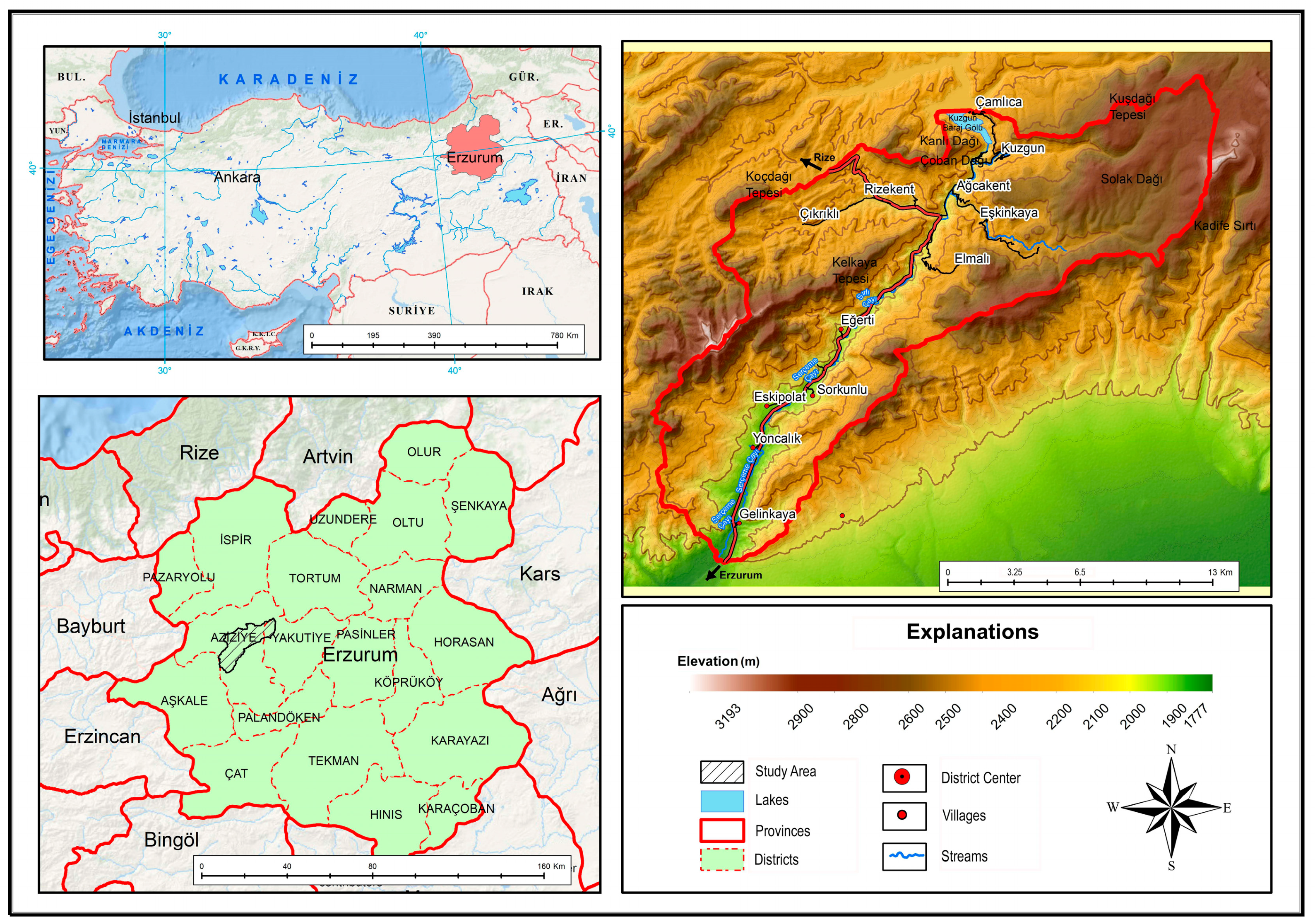
2.1. Study Area
2.2. Methodology
3. Results
4. Discussion
5. Conclusions
Author Contributions
Funding
Institutional Review Board Statement
Informed Consent Statement
Data Availability Statement
Conflicts of Interest
References
- Yeşil, M.; Yılmaz, H. Tozanlı Havzası Tokat-Almus ilçesi ekolojik temelli kırsal peyzaj planlaması. Akad. Ziraat Derg. 2014, 2, 63–74. [Google Scholar]
- Ragon, M. Histoire de I’ Architecture et de I’ Urbanisme Moderns 1; Casterman: Paris, France, 1986; p. 170. [Google Scholar]
- Aciksoz, S.; Bollukcu, P.; Cengiz Gökçe, G. Peyzaj Planlama ve Tasarımında Katılımcı Yöntemler. In Mimarlıkta Peyzaj Tasarımı; Nobel Akademik Yayıncılık: Ankara, Turkey, 2019; pp. 207–229. [Google Scholar]
- Akten, M. Isparta Ovasının Optimal alan Kullanım Planlaması Üzerine bir Araştırma. Ph.D. Thesis, Süleyman Demirel University, Department of Forest Engineering, Isparta, Turkey, 2008. [Google Scholar]
- Zengin, M. Ardahan Kura Nehri Ve Yakın Çevresi Alan Kullanımlarının Belirlenmesi Ve Optimal Alan Kullanım Önerileri. Ph.D. Thesis, Atatürk University, Institute of Science and Technology, Erzurum, Turkey, 2007. [Google Scholar]
- Babalık, A.A. Isparta Yöresinde Arazi kullanımına İlişkin Sorunlar, Süleyman Demirel University. Turk. J. For. 2002, 3, 63–81. [Google Scholar]
- Uzun, O.; Bollukcu, P. Bartın Merkez İlçe Sınırları İçinde Yer Alan Açık Ocak İşletmelerinin Peyzaj Onarımı–Biyolojik Onarım Açısından Değerlendirilmesi. 1. Batı Karadeniz Ormancılık Kongresi, Bartın University. Bartın Orman Fakültesi Derg. 2009, 486–500. [Google Scholar]
- Freising, W.H. Die Landschaftsökologen und die Landschaft. Ber. Reinh. Tüxen-Ges. 1996, 8, 297–309. [Google Scholar]
- Turner, M.G.; Gardner, R.H.; O’neill, R.V. Landcape Ecology in Theory and Practice Pattern and Process; Springer: New York, NY, USA, 2001. [Google Scholar]
- Deniz, B.; Küçükerbaş, E.V.; ve Esbah, T.H. Peyzaj ekolojisine genel bakış. ADÜ Ziraat Fakültesi Dergis 2006, 3, 5–18. [Google Scholar]
- Demir, S.; Demirel, Ö. Peyzaj Planlamada Peyzaj Ekolojisi Yaklaşımı. Türkiye Peyzaj Araştırmaları Derg. 2018, 1, 1–8. [Google Scholar]
- Şahin, Ş. Dikmen VadisiPeyzaj Potansiyelinin Saptanması ve Değerlendirilmesi Üzerine Bir Araştırma. Ph.D. Thesis, Ankara University, Institute of Science and Technology, Department of Landscape Architecture, Ankara, Turkey, 1996. [Google Scholar]
- Herrmann, S.; Osinski, E. Planning sustainable land use in rural areas at different spatial levels using GIS and modelling tools. Landsc. Urban Plan. 1999, 46, 93–101. [Google Scholar] [CrossRef]
- De la Rosa, D.; Moreno, J.A.; Mayol, F.; Bonson, T. Assessment of soil erosion vulnerability in Western Europe and potential impact on crop productivity due to loss of soil depth using the ImpelERO model. Agric. Ecosyst. Environ. 2000, 81, 179–190. [Google Scholar] [CrossRef]
- Prakash, T.N. Land Suitability Analysis for Agricultural Crops: A Fuzzy Multicriteria Decision Making Approach. Master’s Thesis, International Institute for Geo-Information Science and Earth Observation Enschede, Enschede, The Netherlands, 2003. [Google Scholar]
- Feizizadeh, B.; Blaschke, T. Land suitability analysis for Tabriz County, Iran: A multi-criteria evaluation approach using GIS. J. Environ. Plan. Manag. 2012, 56, 1–23. [Google Scholar] [CrossRef]
- Collins, M.G.; Steiner, F.R.; Rushman, M.J. Land use suitability analysis in the United States: Historical development and promising technological achievements. Environ. Manag. 2001, 28, 611–621. [Google Scholar] [CrossRef]
- Ekanayake, G.K.; Dayawansa, N.D.K. Land Suitability Identification for a Production Forest Through GIS Techniques. Map India Conference 2003, India. Available online: http://www.gisdevelopment.net/application/environment/overview/pdf/148.pdf (accessed on 26 February 2025).
- Grooth, R. Function-analysis and valuation as a tool to assess land use conflicts in planning for sustainable, multi-functional landscapes. Landsc. Urban Plan. 2006, 75, 175–186. [Google Scholar] [CrossRef]
- McHarg, I.L. Design with Nature; Natural History Press: Garden City, NY, USA, 1969. [Google Scholar]
- Hopkins, L.D. Methods of generating land suitability maps: A comparative evaluation. J. Am. Inst. Plan. 1977, 43, 386–400. [Google Scholar] [CrossRef]
- Brail, R.K.; Klosterman, R.E. Planning Support Systems; ESRI Press: Redlands, CA, USA, 2001. [Google Scholar]
- Malczewski, J. GIS-based multicriteria decision analysis: A survey of the literature. Int. J. Geogr. Inf. Sci. 2006, 20, 703–726. [Google Scholar] [CrossRef]
- Külahlıoğlu, M.; Doygun, H. Gaziantep Örneğinde Kentsel ve Kırsal Peyzaj Özelliklerinin İncelenmesi ve Peyzaj Planlama Önerileri Geliştirilmesi. Inonu Univ. J. Art Des. 2018, 8, 47–58. [Google Scholar]
- Oh, K.; Jeong, S. Assesing the spatial distribution of urban park using GIS. Landsc. Urban Plan. 2007, 82, 25–32. [Google Scholar] [CrossRef]
- Cengiz, T.; Akbulak, C.; Özcan, H.; Baytekin, H. Gökçeada’da Optimal Arazi Kullanımının Belirlenmesi. Tarım Bilim. Derg. J. Agric. Sci. 2013, 19, 148–162. [Google Scholar]
- Mörtberg, U.M.; Balfors, B.; Knol, W.C. Landscape ecological assesment: A tool for integrating biodiversty issues in strategic environmental assesment and planning. J. Environ. Manag. 2007, 82, 457–470. [Google Scholar] [CrossRef]
- Repetti, A.; Destihieux, G. A relational Indicatorset Model for urban land-use planning and management: Methodological approach and aplication in two case studies. Landsc. Urban Plan. 2006, 77, 196–215. [Google Scholar] [CrossRef]
- Ateş, O.; Uzun, O. Peyzaj Planlama Ve Mekânsal Planlama İlişkisi; Malatya Kenti Örneği. Ph.D. Thesis, Department of Landscape Architecture, Düzce University, Institute of Science, Düzce, Turkey, 2017. [Google Scholar]
- Munroe, D.K.; Croissant, C.; York, A.M. Land use policy and landscape fragmentation in an urbanizing region: Assesing the impact of zoning. Appl. Geogr. 2005, 25, 121–141. [Google Scholar] [CrossRef]
- Otto, R.; Krusi, B.O.; Kienast, F. Degradation of arid coastal landscape in relation to land use changes in Southern Tenerife (Canaria Islands). J. Arid Environ. 2007, 70, 527–539. [Google Scholar] [CrossRef]
- Uzun, O.; Müderrisoğlu, H.; Demir, Z.; Gündüz, S.; Kaya, L.G.; Gültekin, P. Kırsal Mekanların Planlanmasında Peyzaj Kalitesi Kavramı: Yeşilırmak Havzası Örneği. Plan. Derg. 2018, 28 (Suppl. S1), 118–138. [Google Scholar]
- Haase, D.; Walz, U.; Neubert, M.; Rosenberg, M. Changes to Central European Landscapes—Analysing historical maps to approach current environmental issues, examples from Saxony, Central Germany. Land Use Policy 2007, 24, 248–263. [Google Scholar] [CrossRef]
- Blaschke, T. The role of the spatial dimension within the framework of sustainable landscapes and natural capital. Landsc. Urban Plan. 2006, 75, 198–226. [Google Scholar] [CrossRef]
- Bender, O.; Boehmer, H.J.; Jens, D.; Schumacher, K.M. Using GIS to analyse long-term cultural landscape change in Southern Germany. Landsc. Urban Plan. 2005, 70, 111–125. [Google Scholar] [CrossRef]
- Erbesler Ayaşligil, T. Optimal Peyzaj Uygunluk Analizi Yöntemi: Anamur İlçesi Örneği. Megaron 2020, 15, 332–342. [Google Scholar] [CrossRef]
- Hosseini, S.M.; Monavvari, S.M.; Khorshiddoost, A.M.; Rostamzadeh, H.; Naghdi, F.; Ranjbar, G.; Nasir Ahmadi, K.; Ranjbar, G.; Ahmadi, N.A. Ecological Capability Assessment of Tabriz Suburb, Iran, for Urban Development using Multi Criteria Evaluation Approach. Rev. Urban. 2009, 11. [Google Scholar]
- Nabatia, J.; Nezami, A.; Neamatollahi, E.; Akbari, M. GIS-based agro-ecological zoning for crop suitability using fuzzy inference system in semi-arid regions. Ecol. Indic. 2020, 117, 106646. [Google Scholar] [CrossRef]
- Masoudi, M.; Centeri, C.; Jakab, G.; Nel, L.; Mojtahedi, M. GIS Based Multi Criteria and Multi Objective Evaluation for Sustainable Land Use Planning (Case Study: Qaleh Ganj County, Iran) “Landuse Planning Using MCE and Mola”. Int. J. Environ. Res. 2021, 15, 457–474. [Google Scholar] [CrossRef]
- Liu, P.; Hu, Y.; Jia, W. Land use optimization research based on FLUS model and ecosystem services–setting Jinan City as an example. Urban Clim. 2021, 40, 100984. [Google Scholar] [CrossRef]
- Jokar, P.; Masoudi, M. Evaluation of Ecological Capability and Land Use Planning for Different Uses of Land with a New Model of EMOLUP in Jahrom County, Iran; Department of Natural Resources and Environmental Engineering, School of Agriculture, Shiraz University: Shiraz, Iran, 2022. [Google Scholar]
- Md Rahman, M.; Szabó, G. Sustainable Urban Land-Use Optimization Using GIS-Based Multicriteria Decision-Making (GIS-MCDM) Approach. ISPRS Int. J. Geo-Inf. 2022, 11, 313. [Google Scholar] [CrossRef]
- Seyedmohammadi, J.; Navidi, M.N. Applying fuzzy inference system and analytic network process based on GIS to determine land suitability potential for agricultural. Environ. Monit. Assess 2022, 194, 712. [Google Scholar] [CrossRef] [PubMed]
- Erdoğan, Ö.; Çabuk, A.; Memlük, Y.; Perçin, H. Ekolojik Alan Kullanım Kararlarına Uygun Rekreasyon Alanlarının AHP Yöntemi Kullanılarak Kütahya KentiÖrneğinde İrdelenmesi. Harit. Teknol. Elektron. Derg. 2013, 5, 26–36. [Google Scholar]
- Akbulak, C. Gökçeada’da optimal arazi kullanımı seçimi. Tarım Bilim. Derg.—Ziraat Bilim. Derg. 2013, 19, 148–162. [Google Scholar] [CrossRef]
- Kafalı, F. Serçeme Çayı Havzasının Jeomorfolojisi. Master’s Thesis, Atatürk University, Institute of Social Sciences, Department of Geography, Erzurum, Turkey, 1992. [Google Scholar]
- Özey, R. Serçeme Çayı Havzasında Yerleşmenin Coğrafi Özellikleri. Doğu Coğrafya Derg. 1995, 1. [Google Scholar]
- Anonim. Erzurum-Kuzgun Daphan Projesi Yapılabilirlik Raporu; DSİ VIII. Bölge Müdürlüğü: Erzurum, Turkey, 1978. [Google Scholar]
- Özey, R. Rekreasyon Amaçlı Bir Turizm Yöremiz; Serçeme Vadisi. Turizm Yıllığı; Türkiye Kalkındırma Bankası: Ankara, Turkey, 1991. [Google Scholar]
- Solak, Y.T. Serçeme Vadisi’nin (Aziziye, Erzurum) Florası. Master’s Thesis, Artvin Çoruh University, Institute of Science, Department of Forestry Engineering, Artvin, Turkey, 2016. [Google Scholar]
- Yılmaz, S. Serçeme Vadisinin Rekreasyonel Kullanım Potansiyelinin Belirlenmesi. Atatürk University, Ziraat Fakültesi, Peyzaj Mimarlığı Bölümü. Ekoloji Derg. 2004, 13, 1–6. [Google Scholar]
- Çakır, İ. Coğrafi Özellikleri Bakımından Serçeme Çayı Havzası. Master’s Thesis, Atatürk University, Institute of Social Sciences, Department of Geography, Erzurum, Turkey, 2021. [Google Scholar]
- Lyle, T.J. Design for Ecosystems; Van Nostrand Reinhold: New York, NY, USA, 1985; p. 265. [Google Scholar]
- Gürbüz, E.; Pirselimoğlu Batman, Z. Evaluation of Ecologically Based Activities Within the Scope of Sustainable Tourism and Recreation Planning. Sustainability 2025, 17, 2136. [Google Scholar] [CrossRef]
- Ghadimi, N.; Khosravi, F.; Adeli, K. Evaluating recreational and tourism land suitability along the Shirud coast of the Caspian Sea using GIS-based MCDM methods. J. Coast. Conserv. 2022, 26, 46. [Google Scholar]


| Agricultural Land | Forest Land | ||||||
|---|---|---|---|---|---|---|---|
| Land Use | Evaluation | Sub-Criteria | Score | Land Use | Evaluation | Sub-Criteria | Score |
| Criteria | Criteria | ||||||
| Agricultural Land | Land Use Capability Classes | I. Class | 4 | Forest Land | Land Use Capability Classes | I. Class | 1 |
| II. Class | 4 | II. Class | 1 | ||||
| III. Class | 4 | III. Class | 1 | ||||
| IV. Class | 4 | IV. Class | 2 | ||||
| V. Class | 1 | V. Class | 3 | ||||
| VI. Class | 2 | VI. Class | 4 | ||||
| VII. Class | 1 | VII. Class | 3 | ||||
| VIII. Class | 1 | VIII. Class | 1 | ||||
| Other (River, Settlement) | 0 | Others (Stream, Settlement) | 1 | ||||
| Soil Depth | Medium Depth | 4 | Soil Depth | Medium Depth | 4 | ||
| Shallow | 3 | Shallow | 2 | ||||
| Very Shallow | 2 | Very Shallow | 2 | ||||
| Other (Riverbed, Settlement, Bare Rock) | 1 | Other (Riverbed, Settlement, Bare Rock) | 1 | ||||
| Limiting Soil Characteristic | Rocky | 1 | Erosion | None or very little | 4 | ||
| Stony | 2 | Moderate | 3 | ||||
| Poorly Drained | 1 | Severe | 2 | ||||
| Other (Riverbed, Settlement, Bare Rock) | 0 | Very Severe | 2 | ||||
| Erosion | None or very little | 4 | Other (Riverbed, Settlement, Bare Rock) | 1 | |||
| Moderate | 3 | Slope | 0–6 | 1 | |||
| Severe | 1 | 6–12 | 1 | ||||
| Very Severe | 1 | 12–18 | 2 | ||||
| Other (Riverbed, Settlement, Bare Rock) | 1 | 18–24 | 3 | ||||
| Slope | 0–6 | 4 | 24–30 | 4 | |||
| 6–12 | 4 | 30+ | 4 | ||||
| 12–18 | 2 | Precipitation | 344–400 mm | 1 | |||
| 18–24 | 1 | 400–500 mm | 2 | ||||
| 24–30 | 1 | 500–600 mm | 2 | ||||
| 30+ | 1 | 600+ mm | 4 | ||||
| Aspect | South-facing slopes | 3 | Temperature | 1–2 °C | 1 | ||
| East–West | 1 | 2–4 °C | 2 | ||||
| North-facing | 3 | 4–6 °C | 3 | ||||
| Flat Areas | 4 | 6+ °C | 4 | ||||
| Distance to Water Sources | 0–300 m | 4 | Elevation | <2000 m | 4 | ||
| 300–600 m | 3 | 2000–2200 m | 1 | ||||
| 600–900 m | 2 | 2200–2400 m | 1 | ||||
| 900+ m | 1 | >2400 m | 1 | ||||
| Distance to Transportation Networks | 0–1000 m | 4 | Aspect | South-facing slopes | 1 | ||
| 1000–2000 m | 3 | East–West | 3 | ||||
| 2000–4000 m | 2 | North-facing | 4 | ||||
| 4000+ m | 1 | Flat Areas | 2 | ||||
| Temperature | 1–2 °C | 1 | Limiting Soil Characteristic | Rocky | 1 | ||
| 2–4 °C | 2 | Stony | 2 | ||||
| 4–6 °C | 3 | Poorly Drained | 1 | ||||
| 6+ °C | 4 | Other (Riverbed, Settlement, Bare Rock) | 1 | ||||
| Precipitation | 344–400 mm | 1 | |||||
| 400–500 mm | 2 | Tourism and Recreation Areas | |||||
| 500–600 mm | 2 | Land Use | Evaluation | Sub-Criteria | Score | ||
| 600+ mm | 4 | Criteria | |||||
| Land Use | Non-Forest, Meadow, and Pasture Areas | 4 | Tourism and Recreation Areas | Original Rural Landscape | 0–500 | 4 | |
| Forest, Meadow, and Pasture Areas | 1 | 501–1000 | 3 | ||||
| 1001–2000 | 2 | ||||||
| Settlement Areas | 2001–3000 | 1 | |||||
| Land Use | Evaluation | Sub-Criteria | Puan | Picnic Area | 0–500 | 4 | |
| Criteria | 501–1000 | 3 | |||||
| Settlement Areas | Land Use Capability Classes | I. Class | 1 | 1001–2000 | 2 | ||
| II. Class | 1 | 2001–3000 | 1 | ||||
| III. Class | 1 | Site Area | 0–500 | 4 | |||
| IV. Class | 1 | 501–1000 | 3 | ||||
| V. Class | 1 | 1001–2000 | 2 | ||||
| VI. Class | 3 | 2001–3000 | 1 | ||||
| VII. Class | 4 | Vegetation Cover | 0–500 | 4 | |||
| VIII. Class | 4 | 501–1000 | 3 | ||||
| Other (River) | 1 | 1001–2000 | 2 | ||||
| Slope | 0–6 | 4 | 2001–3000 | 1 | |||
| 6–12 | 4 | Unique Topographic Structure | 0–500 | 4 | |||
| 12–18 | 3 | 501–1000 | 3 | ||||
| 18–24 | 2 | 1001–2000 | 2 | ||||
| 24–30 | 2 | 2001–3000 | 1 | ||||
| 30+ | 1 | Cultural Asset | 0–500 | 4 | |||
| Aspect | South-facing slopes | 4 | 501–1000 | 3 | |||
| East–West | 3 | 1001–2000 | 2 | ||||
| North-facing | 1 | 2001–3000 | 1 | ||||
| Flat Areas | 4 | Vista | 0–500 | 4 | |||
| Distance to Water Resources | 0–300 m | 4 | 501–1000 | 3 | |||
| 300–600 m | 3 | 1001–2000 | 2 | ||||
| 600–900 m | 2 | 2001–3000 | 1 | ||||
| 900+ m | 1 | Proximity to Transportation | 0–1000 m | 4 | |||
| Altitude | <2000 m | 4 | 1000–2000 m | 3 | |||
| 2000–2200 m | 3 | 2000–4000 m | 2 | ||||
| 2200–2400 m | 1 | 4000+ m | 1 | ||||
| >2400 m | 1 | Proximity to Water Resources | 0–300 m | 4 | |||
| Geology | Non-alluvial Areas | 4 | 300–600 m | 3 | |||
| Alluvial Areas | 1 | 600–900 m | 2 | ||||
| Vegetation Cover | Forest | 1 | 900+ m | 1 | |||
| Non-forest Areas | 4 | ||||||
| Limiting Soil Property | Rocky | 3 | Conservation Areas | ||||
| Stony | 1 | Land Use | Evaluation | Sub-Criteria | Score | ||
| Criteria | |||||||
| Grassland Areas | Conservation Areas | Historical Sites | Existence | 4 | |||
| Land Use | Evaluation | Sub-Criteria | Score | Non-existence | 1 | ||
| Criteria | Protected Areas | Existence | 4 | ||||
| Grassland Areas | Land Use Capability Classes | I. Class | 4 | Non-existence | 1 | ||
| II. Class | 4 | Vegetation Cover | Existence | 4 | |||
| III. Class | 4 | Non-existence | 1 | ||||
| IV. Class | 4 | Geology | Interesting Geological Formations | 4 | |||
| V. Class | 1 | Alluvial Areas | 1 | ||||
| VI. Class | 2 | Other | 1 | ||||
| VII. Class | 1 | ||||||
| VIII. Class | 1 | Grazing Areas | |||||
| Other (River, Settlement) | 1 | Land Use | Evaluation | Sub-Criteria | Score | ||
| Soil Depth | Medium Depth | 3 | Criteria | ||||
| Shallow | 2 | Grazing Areas | Land Use Capability Classes | I. Class | 1 | ||
| Very Shallow | 1 | II. Class | 1 | ||||
| Other (Riverbed, Settlement, Bare Rock) | 1 | III. Class | 1 | ||||
| Limiting Soil Property | Rocky | 1 | IV. Class | 1 | |||
| Stony | 2 | V. Class | 2 | ||||
| Inadequate Drainage | 4 | VI. Class | 4 | ||||
| Other (Riverbed, Settlement, Bare Rock) | 1 | VII. Class | 4 | ||||
| Erosion | None or Very Low | 4 | VIII. Class | 4 | |||
| Moderate | 3 | Other (River, Settlement) | 1 | ||||
| Severe | 1 | Soil Depth | Medium Depth | 4 | |||
| Very Severe | 1 | Shallow | 2 | ||||
| Other (Riverbed, Settlement, Bare Rock) | 1 | Very Shallow | 1 | ||||
| Slope | 0–6 | 4 | Other (Riverbed, Settlement, Bare Rock) | 1 | |||
| 6–12 | 4 | Limiting Soil Characteristic | Rocky | 4 | |||
| 12–18 | 3 | Stony | 3 | ||||
| 18–24 | 1 | Inadequate Drainage | 3 | ||||
| 24–30 | 1 | Other (Riverbed, Settlement, Bare Rock) | 1 | ||||
| 30+ | 1 | Erosion | None or Very Low | 4 | |||
| Aspect | South-facing slopes | 3 | Moderate | 3 | |||
| East–West | 2 | Severe | 1 | ||||
| North-facing | 3 | Very Severe | 1 | ||||
| Flat Areas | 4 | Other (Riverbed, Settlement, Bare Rock) | 1 | ||||
| Distance to Water Resources | 0–300 m | 4 | Slope | 0–6 | 1 | ||
| 300–600 m | 3 | 6–12 | 1 | ||||
| 600–900 m | 2 | 12–18 | 2 | ||||
| 900+ m | 1 | 18–24 | 3 | ||||
| Distance to Transportation Networks | 0–1000 m | 4 | 24–30 | 4 | |||
| 1000–2000 m | 3 | 30+ | 4 | ||||
| 2000–4000 m | 2 | Erosion | None or Very Low | 3 | |||
| 4000+ m | 1 | Moderate | 2 | ||||
| Temperature | 1–2 °C | 1 | Severe | 3 | |||
| 2–4 °C | 2 | Very Severe | 4 | ||||
| 4–6 °C | 3 | Distance to Transportation Networks | 0–1000 m | 4 | |||
| 6+ °C | 4 | 1000–2000 m | 3 | ||||
| Precipitation | 344–400 mm | 1 | 2000–4000 m | 2 | |||
| 400–500 mm | 2 | 4000+ m | 1 | ||||
| 500–600 mm | 2 | Precipitation | 344–400 mm | 1 | |||
| 600+ mm | 4 | 400–500 mm | 2 | ||||
| 500–600 mm | 2 | ||||||
| 600+ mm | 4 | ||||||
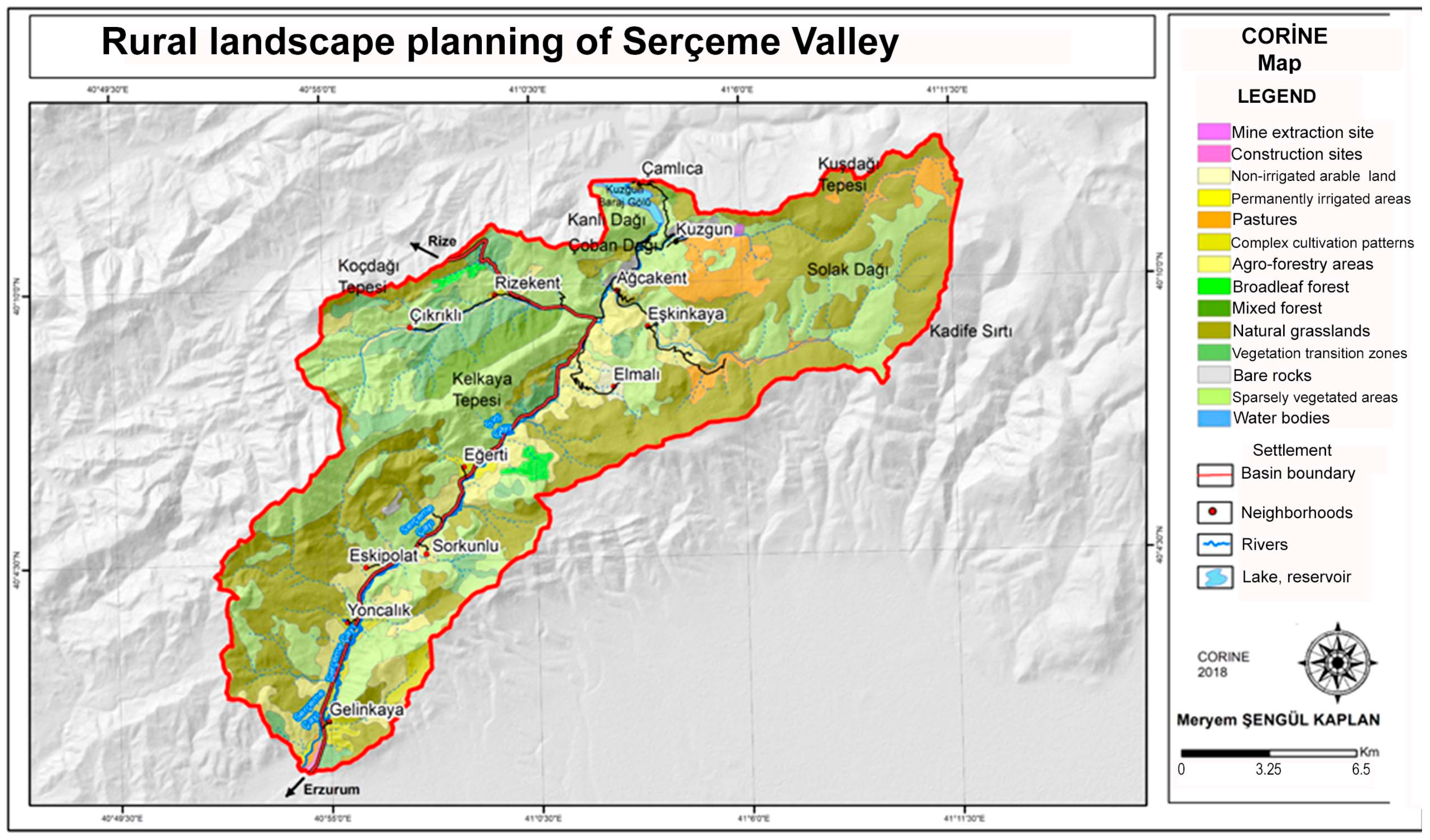
| CORINE Classification | Area (ha) | % | CORINE Classification | Area (ha) | % |
|---|---|---|---|---|---|
| Vegetation Change Areas | 1645 | 6.05 | Mixed Agricultural Areas | 589 | 2.17 |
| Bare Rocks | 193 | 0.71 | Mining Extraction Sites | 27 | 0.1 |
| Agriculture with Natural Vegetation | 2809 | 10.33 | Pastures | 1210 | 4.45 |
| Natural Grasslands | 9804 | 36.04 | Sparse Vegetation Areas | 9661 | 35.52 |
| Broadleaf Forest | 208 | 0.77 | Water Bodies | 153 | 0.56 |
| Construction Sites | 34 | 0.13 | Non-Irrigated Arable Land | 116 | 0.43 |
| Mixed Forest | 606 | 2.23 | Permanently Irrigated Land | 146 | 0.54 |
| Total | 27,200 | 100 |
| Optimal Land Use | Area (ha) | % |
|---|---|---|
| Meadow | 4205.12 | 15.46 |
| Protected Areas | 794.24 | 2.92 |
| Pasture | 11,600.80 | 42.65 |
| Forest | 8788.32 | 32.31 |
| Agriculture | 1107.04 | 4.07 |
| Tourism and Recreation | 440.64 | 1.62 |
| Settlement | 261.12 | 0.96 |
| Total | 27,200 | 100 |
| Optimal Land Use | Area (ha) | % | Current Land Use | Area (ha) | % |
|---|---|---|---|---|---|
| Protected Areas, Sparse Vegetation, Other | 794.24 | 2.92 | Protected Areas, Sparse Vegetation, Other | 9981 | 36.7 |
| Meadow | 4205.12 | 15.46 | Meadow | 9804 | 36.0 |
| Pasture | 11,600.80 | 42.65 | Pasture | 1210 | 4.4 |
| Forest | 8788.32 | 32.31 | Forest | 2459 | 9.0 |
| Agriculture | 1107.04 | 4.07 | Agriculture | 3659 | 13.5 |
| Settlement | 261.12 | 0.96 | Settlement | 87 | 0.3 |
| Tourism and Recreation | 440.64 | 1.62 | Tourism and Recreation | 0 | 0 |
| Total | 27,200 | 100 | Total | 27,200 | 100 |
Disclaimer/Publisher’s Note: The statements, opinions and data contained in all publications are solely those of the individual author(s) and contributor(s) and not of MDPI and/or the editor(s). MDPI and/or the editor(s) disclaim responsibility for any injury to people or property resulting from any ideas, methods, instructions or products referred to in the content. |
© 2025 by the authors. Licensee MDPI, Basel, Switzerland. This article is an open access article distributed under the terms and conditions of the Creative Commons Attribution (CC BY) license (https://creativecommons.org/licenses/by/4.0/).
Share and Cite
Şengül Kaplan, M.; Yılmaz, H. Determination of Land Uses in the Serçeme Basin and Examination of Optimal Land Use. Sustainability 2025, 17, 3682. https://doi.org/10.3390/su17083682
Şengül Kaplan M, Yılmaz H. Determination of Land Uses in the Serçeme Basin and Examination of Optimal Land Use. Sustainability. 2025; 17(8):3682. https://doi.org/10.3390/su17083682
Chicago/Turabian StyleŞengül Kaplan, Meryem, and Hasan Yılmaz. 2025. "Determination of Land Uses in the Serçeme Basin and Examination of Optimal Land Use" Sustainability 17, no. 8: 3682. https://doi.org/10.3390/su17083682
APA StyleŞengül Kaplan, M., & Yılmaz, H. (2025). Determination of Land Uses in the Serçeme Basin and Examination of Optimal Land Use. Sustainability, 17(8), 3682. https://doi.org/10.3390/su17083682