Article

Advancing Sustainability and Resilience in Vulnerable Rural and Coastal Communities Facing Environmental Change with a Regionally Focused Composite Mapping Framework

1
School of Science Engineering and The Environment, University of Salford, Salford M5 4WT, UK
2
Department of Life Sciences, Aberystwyth University, Aberystwyth SY23 3FL, UK
3
College of Health and Science, University of Lincoln, Lincoln LN6 7TS, UK
4
Innovative River Solutions, Institute of Agriculture and Environment, Massey University, Auckland 4442, New Zealand
5
Centre for the Study of the Inland, La Trobe University, Melbourne 3086, Australia
6
Multidisciplinary Research Centre, University of Namibia, Windhoek 10026, Namibia
*
Author to whom correspondence should be addressed.
Sustainability 2025, 17(17), 8065; https://doi.org/10.3390/su17178065 (registering DOI)
Submission received: 1 July 2025 / Revised: 20 August 2025 / Accepted: 28 August 2025 / Published: 8 September 2025
(This article belongs to the Special Issue Sustainable Flood Risk Management: Challenges and Resilience)

Abstract

Rural and coastal communities in areas of socio-economic deprivation face increasing exposure to compound climate-related hazards, including flooding, erosion and extreme heat. Effective adaptation planning in these contexts requires approaches that integrate physical hazard modelling with measures of social vulnerability in a transparent and reproducible way. This study develops and applies the Adaptive and Resilient Rural-Coastal Communities in Lincolnshire (ARRCC-L) framework, a sequential process combining data collation, two-dimensional hydraulic simulation using LISFLOOD-FP, and composite vulnerability mapping. The framework is versioned and protocolised to support replication, and is applied to Lincolnshire, UK, integrating UKCP18 climate projections, high-resolution flood models, infrastructure accessibility data and deprivation indices to generate multi-scenario flood exposure assessments for 2020–2100. The findings demonstrate how open, reproducible modelling can underpin inclusive stakeholder engagement and inform equitable adaptation strategies. By situating hazard analysis within a socio-economic context, the ARRCC-L framework offers a transferable decision support tool for embedding resilience considerations into regional planning, supporting both local adaptation measures and national risk governance.

1. Introduction

Global evidence indicates that deprivation significantly exacerbates vulnerability to regional environmental changes, as socio-economic disadvantages limit community capacity to adapt and respond effectively [1,2,3,4,5,6,7,8,9,10,11,12]. Exploring these dynamics further through a UK-focused lens is crucial for detailing a context-specific example of how these global issues manifest on a regional scale. With a diverse makeup of rural and coastal communities, the UK offers a valuable insight to the interplay between environmental risks and the socio-economic factors that define these communities, thereby serving as a microcosm for understanding similar challenges worldwide.
Complementing the compounded hazard-vulnerability link identified by Green et al. [4], this section introduces ARRCC-L—an integrated workflow framework that combines hydrodynamic hazard simulation with locally specified socio-environmental vulnerability composites. The framework addresses critical gaps in reproducibility, scenario transparency, and deprivation-sensitive resilience mapping, offering a novel tool for participatory planning and regional climate risk assessment.
Building on this framework, this paper asks: how can a fully documented, multi-scenario socio-environmental modelling framework inform equitable adaptation planning and sustainable resilience in deprived rural and coastal communities facing compound flood hazards under climate change? To answer this, the Adaptive and Resilient Coastal Communities in Lincolnshire (ARRCC-L) framework has been independently designed, developed and applied. ARRCC-L comprises a sequential pipeline of data collation, hydraulic simulation via LISFLOOD-FP and stakeholder-driven vulnerability-composite mapping, with each step openly versioned and protocolised to ensure transparency and reproducibility. While full public release of all data and workflows remains aspirational, the framework here outlined does, itself provide a transferable modelling architecture that can be adapted for other regions with evolving climate projections up to 2100.
In this study, resilience is understood as a multidimensional and dynamic capacity that evolves through the interactions of environmental, social and governance systems. Following the socio-ecological systems perspective [5,6], we recognise resilience not as a static end-state but as the ability to absorb disturbances, adapt to change and, where necessary, transform in response to long-term shifts. Within the context of rural and coastal communities, resilience encompasses physical preparedness, institutional adaptability, and the capacity to maintain essential functions and identity under climate-related pressures [7]. The ARRCC-L framework therefore integrates hazard modelling with socio-economic and ecological data to capture both the tangible and intangible factors that underpin this capacity. This approach allows resilience to be operationalised in a manner that is measurable, context-specific and responsive to the complex realities of climate change adaptation.

1.1. Literature Review

Recent research has increasingly examined the intersection of compound flood hazards and socio-economic vulnerability in coastal and rural communities [1]. Advances in socio-ecological systems theory highlight the importance of place-based, multi-scalar frameworks that integrate environmental dynamics with structural deprivation [8,9]. However, much of the existing literature still addresses physical and social risks in isolation or relies on coarse regional aggregations that limit local applicability [10]. In parallel, reproducible environmental modelling workflows remain rare in regional planning contexts, particularly those incorporating stakeholder co-development from the outset [11,12]. Within the UK, efforts to map flood risk and resilience seldom integrate deprivation metrics directly, nor do they offer transparent protocols for applying future climate projections.
Against this backdrop, ARRCC-L responds to several of these gaps. It builds on hydrodynamic hazard simulation and couples it with a locally specified socio-environmental vulnerability composite, enabling more granular, context-specific assessments than the predominantly sectoral or nationally aggregated approaches found in the current literature. By aligning reproducible modelling methods with locally relevant social data and stakeholder engagement, ARRCC-L advances the field from descriptive risk mapping towards a transferable decision-support tool for integrated climate adaptation planning.

1.2. Study Objectives and Paper Structure

To demonstrate how a reproducible, multi-scenario socio-environmental modelling framework can support equitable adaptation planning and sustainable resilience, this paper delivers three primary contributions:
  • A transparent, openly versioned pipeline that links regional data collation, 2D hydraulic simulation (LISFLOOD-FP) and stakeholder-driven composite vulnerability mapping, ensuring full reproducibility at each stage.
  • A spatially explicit integration of high-resolution flood-risk outputs with multidimensional socio-economic and health deprivation indices, enabling precise identification of priority zones under present and future climate scenarios.
  • A transferable blueprint for equitable adaptation planning that embeds stakeholder engagement and policy relevance, offering practitioners a clear framework for resilient development across similar rural and coastal settings.
The remainder of the manuscript is structured as follows. Section 2 reviews the literature on compound flood hazards and socio-environmental vulnerability. Section 3 presents the ARRCC-L conceptual design and detailed methodology. Section 4 reports the framework outputs and evaluates their implications for long-term spatial planning. Section 5 concludes with limitations, future research directions, and actionable recommendations for planners.
To ground the framework in regional socio-economic realities, deprivation metrics are drawn from three key sources: the UK Poverty Statistics Dashboard from the Joseph Rowntree Association [13], the Cost of Living Data Dashboard provided by Citizens Advice [14], and the English Indices of Deprivation 2019 from the Ministry of Housing, Communities & Local Government [15]. These data reveal that many UK rural and coastal communities face significant and growing socio-economic challenges. These communities often rank in the lowest decile nationally in the UK ‘Access to Healthy Assets and Hazards’ (AHAH) score mapping, particularly those situated in coastal zones [16]. This socio-economic profile implies a diminished adaptive capacity and elevated exposure to future climate-related risk, echoing the challenges faced by similarly profiled communities around the globe [17,18,19,20]. Additionally, this deprived status signifies an attenuated capacity for these populations to adapt to the pressures of a changing climate, which are projected to be most acute in the UK by 2050, at the coastal interface [21,22,23,24]. Compounded by the need to review the status of the vast complex of mixed flood defences protecting these communities from environmental hazards within the region, the regional government, the Environment Agency (EA), and academic institutions engaged in a collaborative endeavour to support the region’s communities inhabiting the land around these defences into the future. This initiative aimed to inform and guide long-term social, economic, and environmental resilience, and better orientate adaptation strategies towards regional environmental change. The ARRCC-L project brought together expertise across various levels of governance and management to inform an integrated analysis, evaluation, and engagement strategy to this end, further aiming to optimise regional resilience against climate change over the next 100 years. To this end, several transferable aims were identified and collectively agreed upon at the outset of this endeavour:
  • Develop a strategy to optimise coastal prosperity in the face of climate change over the next century.
  • Inform resilient spatial development patterns over the next 25 years within a long-term strategic view, enabling communities to thrive.
  • Identify routes for community engagement, highlighting the need for resilience and adaptation across socio-economic and environmental considerations.
  • Evaluate a multidisciplinary response to various facets of social, economic, and environmental issues, beyond the risk of flooding, considering the prosperity and value of coastal communities.
  • Recognise the potential for challenging and controversial decisions, potentially unsupported by legislative or financial frameworks.
Together, these aims set out a one-hundred-year vision for the region’s coast, with a twenty-five-year ‘tactical’ horizon for delivering more resilient spatial development patterns based on climate-driven flood dynamics, to be partly delivered through a ‘Local Plan’ for the region. Geographically, the region’s expansive ‘coastal strip’ extends between Saltfleet and Gibraltar Point (~37 miles) (Figure 1), extending inland to the foot of the Wolds (~10–20 miles); with a total area of ~2690 square miles. The ARRCC-L framework connects these areas, through a regional strategy for environmental change, to the similar Humber Strategy [25,26] in action to the North of the region and The Wash Strategy to the South [27,28], establishing an integrated regional strategy for environmental change along the East coast of the UK. The framework further provides a future-informed context within which local planning strategies can be developed and approved, feeding into a wider strategic and investment framework for the partner organisations involved in the project. While other studies have assessed climate risks and socio-economic pressures in vulnerable coastal zones, many have lacked a consolidated modelling framework like ARRCC-L to systematically align hydrodynamic risk with localised deprivation and infrastructure vulnerabilities.
The project also establishes a context for future decisions made across the various scales of governance and planning with regional environmental change in mind. The ARRCC-L framework therefore stands as a multi-scale model for strategic partnership, filling the gap presented by the need for improved regional understanding of climate change impacts, growth, prosperity, and sustainability.

2. The Adaptive and Resilient Rural-Coastal Communities in Lincolnshire (ARRCC-L) Framework

Enhancing the understanding of sustainability and resilience in vulnerable communities amidst regional environmental change is fundamental to achieving equitable planning and adaptation strategies [6]. The Adaptive and Resilient Rural-Coastal Communities in Lincolnshire (ARRCC-L) framework is an independently developed, regionally focused methodology designed to assess compound flood risk and socio-environmental vulnerability. ARRCC-L comprises a sequential pipeline of data collation, 2D hydraulic simulation (LISFLOOD-FP), and stakeholder-driven composite vulnerability mapping. Each step is designed to be openly versioned and protocolised, with the aspiration of full public release of the framework to support reproducibility and transferability. The collaboratively established framework aims to facilitate this by encouraging a co-developed strategy for engaging with community resilience and local capacities to respond and adapt to the impacts of climate change based on the modelling of different impact scenarios using social and environmental data. The region’s combination of extensive coastline, engineered flood defences, and high deprivation scores makes it a multifaceted regional case study for testing ARRCC-L’s capacity to inform equitable, region-specific adaptation planning. At the regional scale, Lincolnshire provides a representative testing ground for the ARRCC-L framework not only due to its extensive flood risk and socio-economic vulnerability, but also because it exhibits compound dynamics including coastal exposure, ageing infrastructure, rural isolation, and uneven deprivation; that are mirrored across many low-lying regions in the UK and globally.
By applying ARRCC-L to this setting, the framework can capture scalable insights into systemic patterns of hazard-vulnerability interaction and adaptation gaps that often emerge across regional planning levels. These insights can further inform adaptation strategies in similarly complex coastal and inland environments, particularly where siloed infrastructure and policy responses have hindered integrated resilience planning.
This offers a means to deeply examine the intersecting socio-economic and environmental challenges faced by these communities, enabling planners to ensure that adaptation measures can be tailored to address specific regional vulnerabilities and needs [29,30]. This can foster a sense of inclusivity and fairness, ensuring that all community members benefit from resilience-building efforts, building on social strengths evidenced within these communities [31]. It also supports the development of targeted interventions that can mitigate the impacts of climate change more effectively, thereby promoting long-term sustainability for these communities. By integrating comprehensive socio-environmental data and fostering collaboration across various governance levels, this understanding ensures that adaptation strategies are not only effective but also just and equitable, empowering vulnerable communities to thrive in the face of environmental [31,32].
The social strengths of coastal communities are often closely tied to the landscape. Along the Eastern coastal region of the UK, the legacy of the 1953 Great North Sea flood event has profoundly impacted the resident communities and continues to in the 70 years since the event. Driven by a significant tidal surge, 24,000 homes were flooded, 307 deaths were recorded (with 43 in Lincolnshire) and 30,000 people were displaced. A 2013 estimate of the total event impact was £1.2 billion in economic losses [33]. The synergy of climatic, tidal, and human factors that brought about this event and generated such pronounced impacts has since ensured a dedicated service to monitoring tidal behaviour in the region, as well as reinforced collaborative mitigation strategies which ensure that the impacts from any similar event reoccurrence are minimised [34,35].
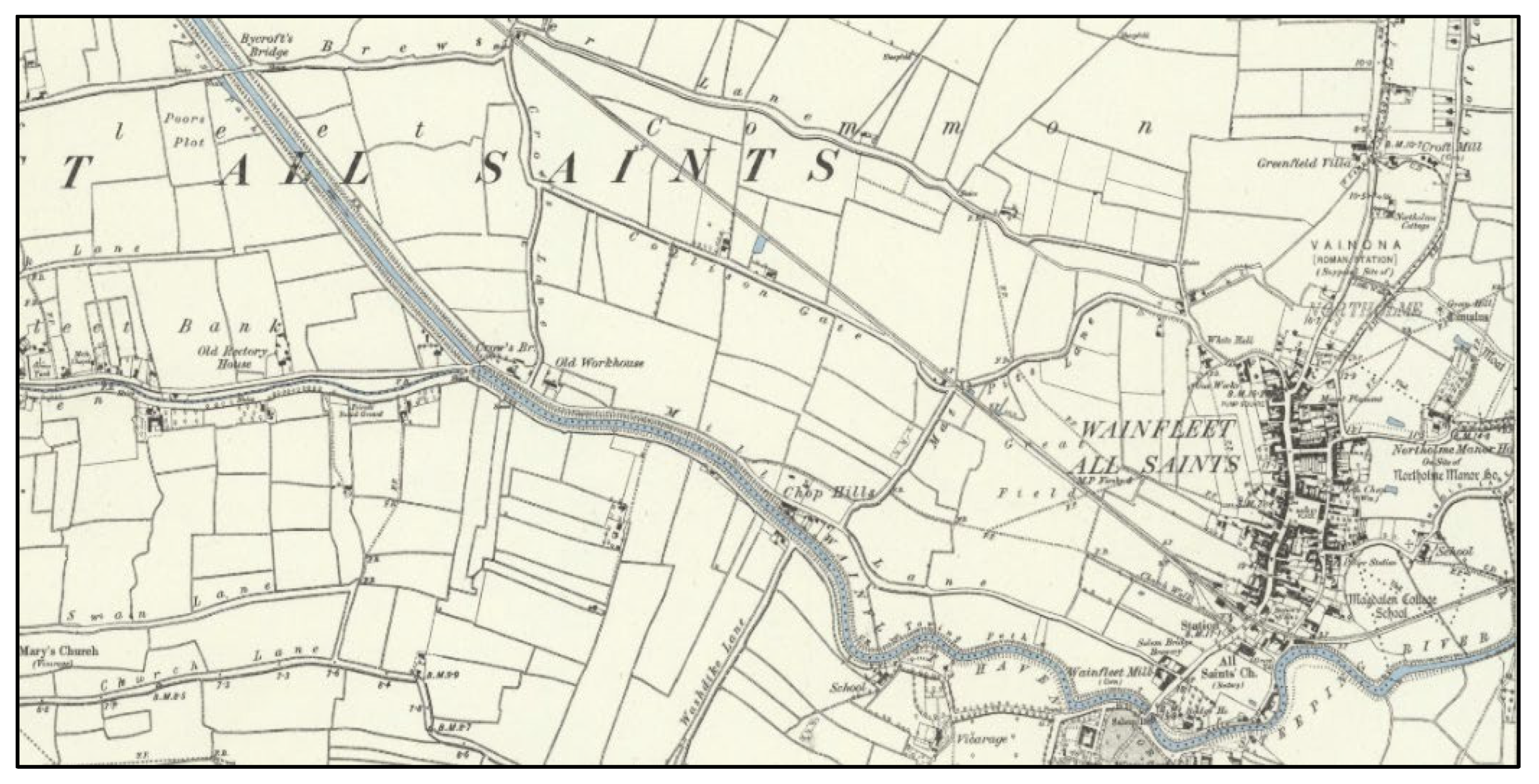
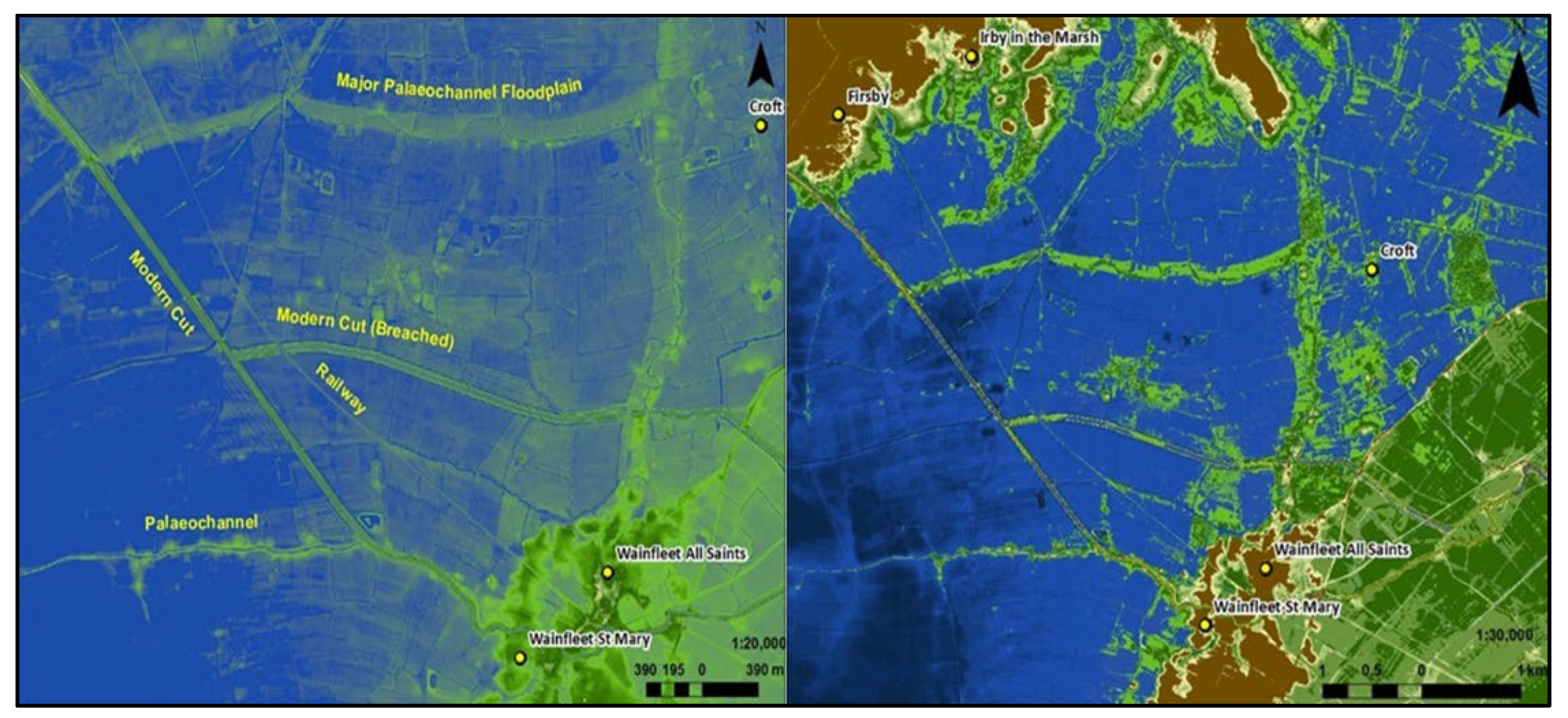
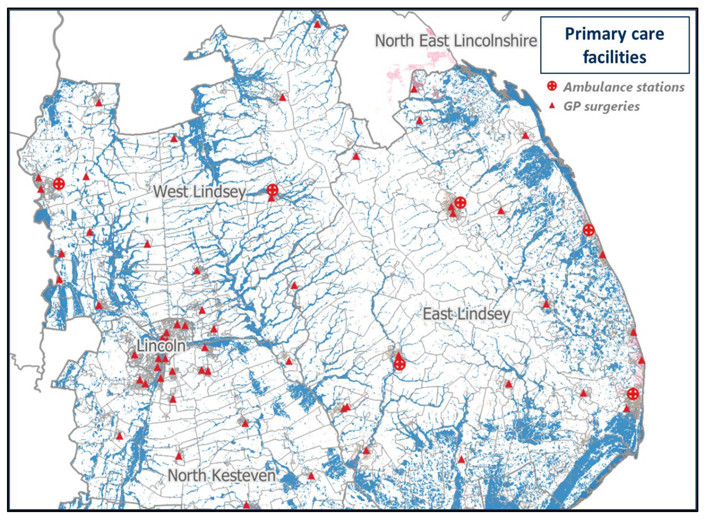
By comparison, the 2019 regional floods caused by Storm Ciara [36] had a substantial impact on infrastructure in the same region, but with a significantly reduced human cost compared to the 1953 event, with 1100 homes flooded, and one death recorded [33,37]. Importantly, the regional landscape is augmented with watercourses that have been extensively modified since the 17th century CE (Figure 2 and Figure 3), influencing the flood experience in distinctive ways [33]. The contrasting outcomes of these historical events highlight the region’s differing vulnerabilities to pluvial and coastal floods [38], with improvements expected since 1953, as suggested by the 2019 event. The ARRCC-L framework builds on this resilience by leveraging historical data and climate projections to create high-resolution flood maps, showcasing how past dynamics will interact with future climate change. This approach supports strategic growth for coastal communities by pinpointing areas of current and future flood risk, even as rising sea levels and increased flooding threaten the entire region [39].
Guided by these insights, future planning for vulnerable communities focuses on fostering growth and business resilience to withstand climate variability [40,41]. Resilience is essential to mitigate the economic and environmental impacts of relocation or displacement [42], while proactive adaptation pathways can foster diverse and sustainable economies in flood-prone regions [43,44]. However, defining optimal strategies for evolving coastlines up to and beyond 2050 remains a complex, multi-scale challenge [45,46,47], with responses varying from ‘Hold-the-Line’ (HtL) strategies to hybrid approaches [48,49].

Conceptual Design

To address these challenges, the ARRCC-L team devised a robust modelling system aligned with the need for a regional adaptation strategy. By integrating regional social and environmental data, the system demonstrates climate change impacts through a temporally distributed impact scenario framework. These mapped outputs highlight the socio-environmental strengths of the region, supporting an optimised approach toward future coastal prosperity amid environmental change.
This evidence-based, multi-scenario approach not only emphasises community-level resilience to extreme flood events but also serves as a platform for detailed interrogation of regional patterns of coastal resilience and adaptation, including strategies such as HtL and other contemporary approaches. By enabling the exploration of potential impacts from interactions between adaptive and transformative methods, the system helps inform preparedness, response, and recovery in future flooding incidents.
Effectively applying these insights across socio-economic and needs-based boundaries requires a place-based understanding of well-being, education, economics, development, climate, and water infrastructure [50]. The ARRCC-L framework addresses this by incorporating social data to emulate the diverse nature of coastal areas, ranging from more developed towns to smaller settlements, and regions with seasonal population fluxes. By intersecting these dynamics with climate and flood data, the system illustrates the risk and vulnerability dynamics across different demographic groups within the region, laying a foundation for informed, resilient strategies that balance both current and future challenges [8,51].
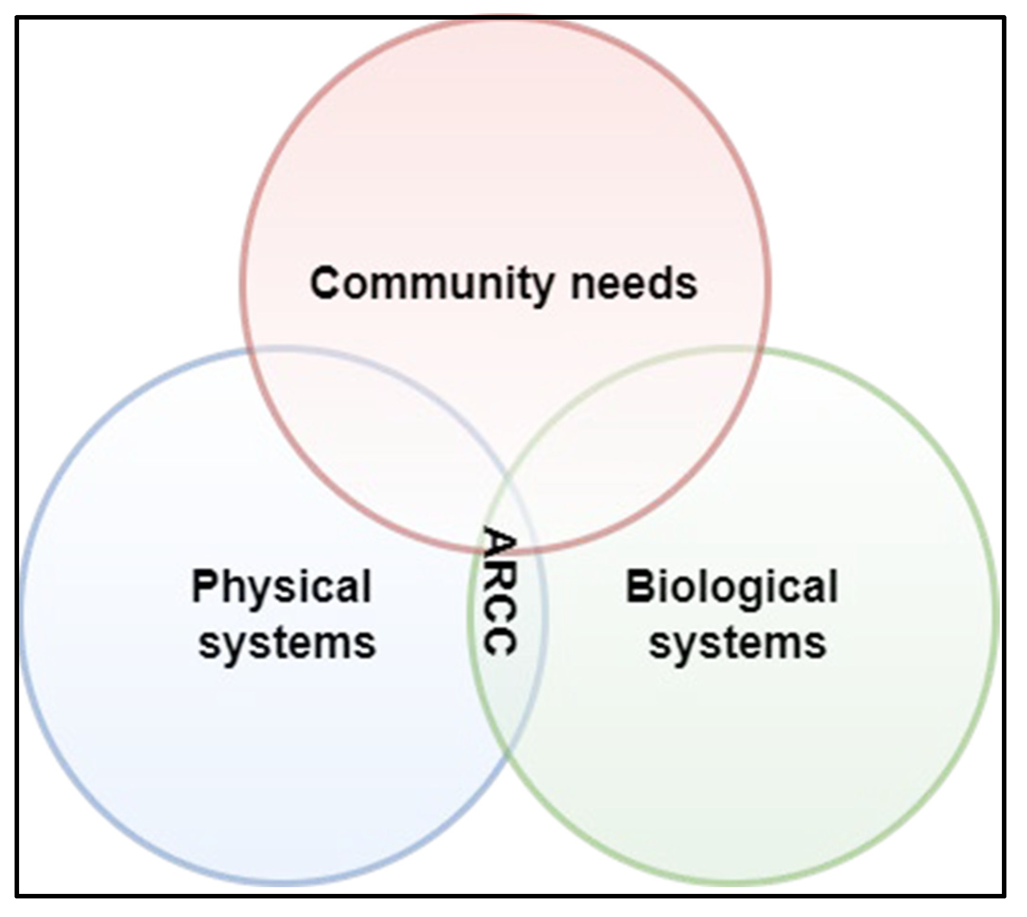
The ARRCC-L framework, captured in a conceptual diagram (Figure 4), bridges physical and biological systems to address current and future community needs. By mapping risk and exposure variables into the future, it functions as a predictive, process-based model akin to ecosystem service mapping [52]. This model supports the creation of resilient coastal and rural communities and businesses as they adapt to environmental changes. Offering a visual assessment of climate change impacts, it builds an evidence base for co-development in the coastal zone and guides flood management strategies—an approach readily adaptable to similar regions facing climate challenges.
While strategies like ‘making space for water’ [55] and ‘living with climate change’ [56] are viable for regional adaptation, Lincolnshire’s coastal historical development limits their practicality compared to regions with longer or more structured geographical progressions [57,58]. Ancient watercourses (paleochannels or ‘roddons’ see Figure 3 for reference) underlying modern flood management infrastructure create vulnerabilities, heightened by the uncertainties of climate-driven coastal changes [59]. Effective coastal sustainability strategies must consider these historic specificities to manage flood risks effectively. Rising sea levels and more frequent extreme weather events add further pressure, requiring costly reassessments of engineered waterways and defences [60,61]. Leveraging Lincolnshire’s historical flood data, the ARRCC-L framework addresses these complexities by focusing on high-likelihood compound scenarios to guide forward-thinking planning, integrating regional social and health infrastructure dynamics.
Effective coastal adaptation also hinges on partnerships among residents, monitoring agencies, and governance bodies [62]. The ARRCC-L framework supports such collaboration, enabling coastal regions to rethink resilience and infrastructure. Globally, coastal hubs drive economic prosperity but face socio-economic challenges tied to seasonality, including fluctuating employment and population movements that impact education, skills, and health [63,64]. Nonetheless, significant tourism growth in many coastal areas highlights the importance of balanced planning to mitigate potential negative impacts [39,65]. By facilitating these critical interactions, the ARRCC-L framework strengthens regional resilience and ensures a strategic approach to adaptation [66].

3. Methodology

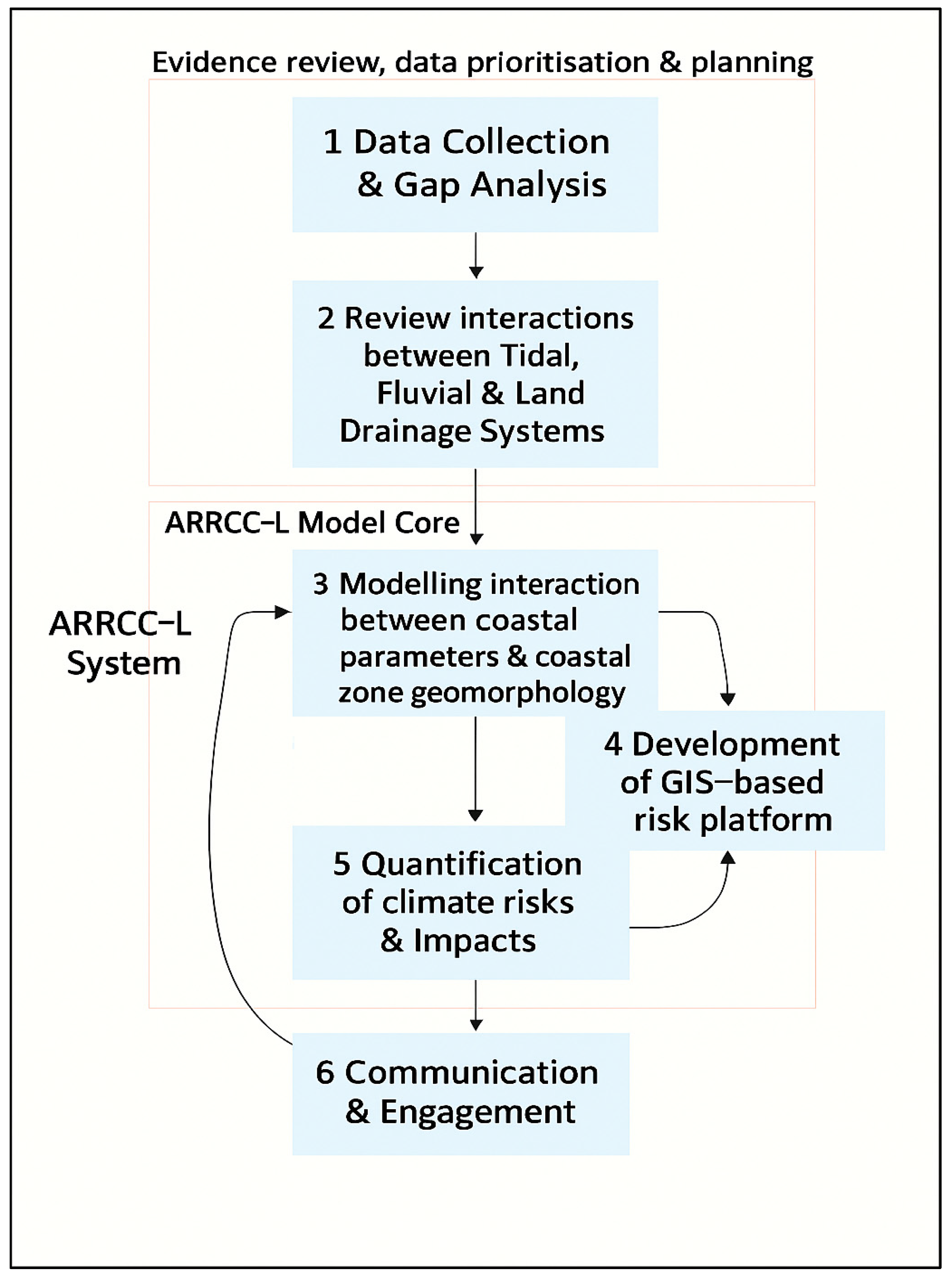
Following the ARRCC-L framework (Figure 5), three priority strategies emerged to achieve the project’s aims:
  • Integrated Flood Risk Management: Develop a holistic catchment-to-coast approach by expanding regional flood risk assessments and adaptation strategies. This ensures inland, coastal, and combined event risks are addressed, avoiding the relocation of communities and infrastructure to equally or more flood-prone areas.
  • Strategic Partnership: Foster collaboration between local governments, environmental agencies, and academic institutions. These partnerships strengthen community resilience by combining diverse expertise and resources to inform effective climate adaptation and mitigation efforts.
  • Data Integration and Analysis: Systematically model and analyse decades of hydromorphic, hydrological, and historical flood data. This integration is critical for understanding and managing future flood risks while guiding adaptive strategies.
Although the future cannot be predicted precisely, local governance and stakeholders can engage meaningfully with systems that evaluate the likely impacts of climate-related flood changes through ‘as-good-as-possible’ projections [67]. These projections are best conveyed through mapped scenarios that illustrate the effectiveness and resilience of various development and adaptation strategies, fostering ‘resistance to any disturbance’ [68].
The ARRCC-L nexus (Figure 4) simplifies perspectives for engineering and operationalising resilience by addressing system conflicts—for instance, flooded homes, coastal erosion, or degraded ecosystems [69]. This simplified approach guides collaborative strategies to resolve connectivity issues when the regional system is severely impacted [68]. To ensure effectiveness, this system requires a multi-faceted set of inputs for mobilising and operationalising data with a future-oriented perspective [70,71].
Surveys of existing regional features alone, such as buildings and flood defences, are insufficient for long-term planning, particularly in the face of climate change and rising sea levels [61]. Addressing these gaps, six priority components were identified for a modelling system tailored to regional environmental change (Figure 5), expanding on earlier intervention strategies:
  • Coastal Processes: Integrate historical maps, aerial photographs, and satellite imagery to track ongoing coastal processes.
  • River Flooding: Use EA flood maps or similar zoning data as a foundation, supplemented by ‘what if’ modelling of future flood extents.
  • Infrastructure Vulnerabilities: Analyse historical maps of coastal and river drainage changes, including embankment breaches, to identify weak points in flood protection infrastructure.
  • Ecosystem Mapping: Develop maps highlighting ecosystem quality and services—from brownfield sites to woodlands and wildlife sanctuaries—as identified in the ‘Habitat extent and condition, natural capital, UK:2022’ report [72].
  • Built Environment Evaluation: Assess property quality and future built environment conditions, incorporating hazard liability and development needs. Explore broader benefits like agricultural, economic, and social value tied to adaptive strategies [9].
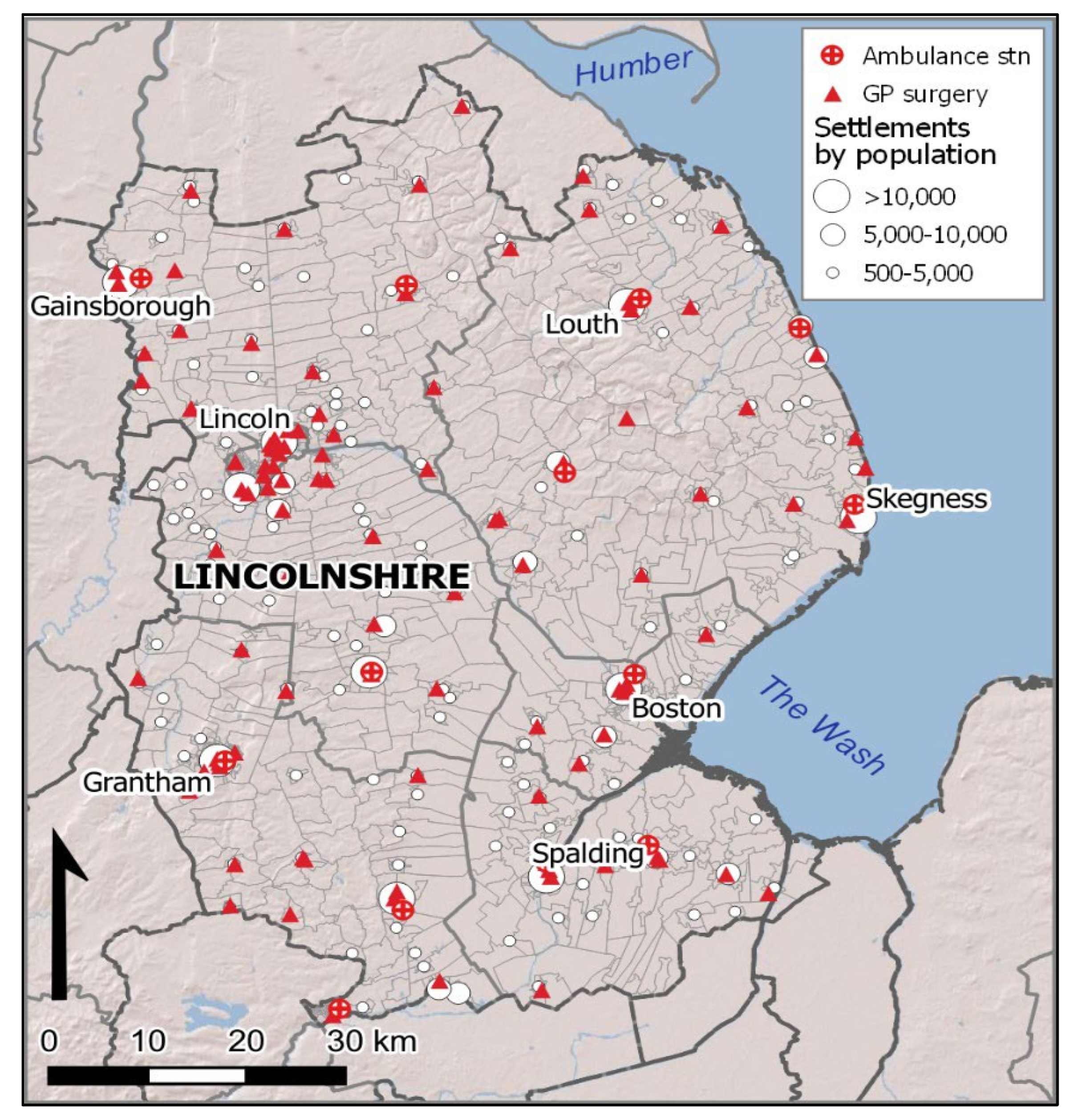
  • Health, Social, and Economic Data: Create map layers targeting areas needing intervention, ensuring emergency access to properties and health infrastructure—often overlooked in standard planning [62]. These inputs inform the spatial risk platform, quantifying climate risks, impacts, and opportunities [8,73].
To bridge the conceptual framework in Figure 4 with the process flow in Figure 5, each of the six blue-square modules in Figure 5 is mapped onto the three overlapping domains of community needs, physical systems and biological systems. Modules 1–5 operationalise the physical systems domain, with Modules 1 and 4 explicitly incorporating biological-system inputs (e.g., habitat and ecosystem layers). Module 6 aligns with the community needs domain, closing the loop between scientific analysis and stakeholder engagement. This direct correspondence ensures that the transition from high-level integration (Figure 4) to detailed implementation (Figure 5) is both transparent and traceable.

3.1. Framework Design

The ARRCC-L framework consists of:
  • Data Collation: Integration of regional deprivation indices, infrastructure accessibility, and historical flood records.
  • Hydraulic Simulation: Use of LISFLOOD-FP over high-resolution LiDAR terrain data to model fluvial, pluvial, and coastal flood scenarios.
  • Composite Vulnerability Mapping: Stakeholder-weighted overlays of hazard exposure and socio-economic indicators to identify priority zones for adaptation.
The ARRCC-L framework is based on a modelling approach of six core components, leveraging Lincolnshire’s extensive history of coastal and inland flooding, to provide a robust evidence base for planning and mitigating environmental change. Anchored by the established Humber Strategy [27] in the north of the region and the developing Wash Strategy [28] in the south f the region, the ARRCC-L framework informs regional-scale planning and identifies strategic pathways aligned with the region’s socio-environmental dynamics.
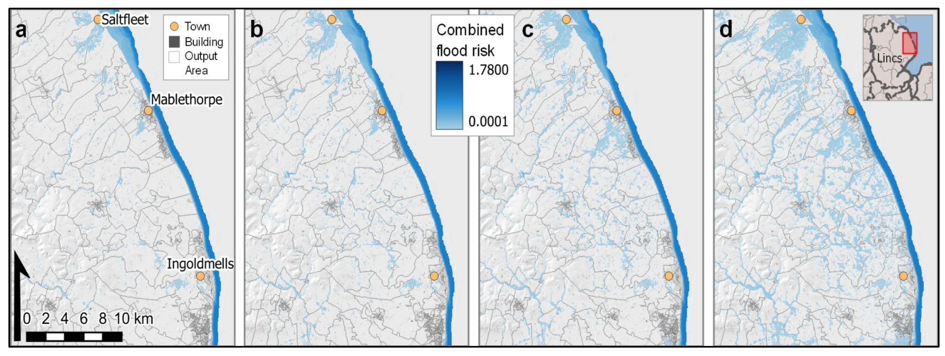
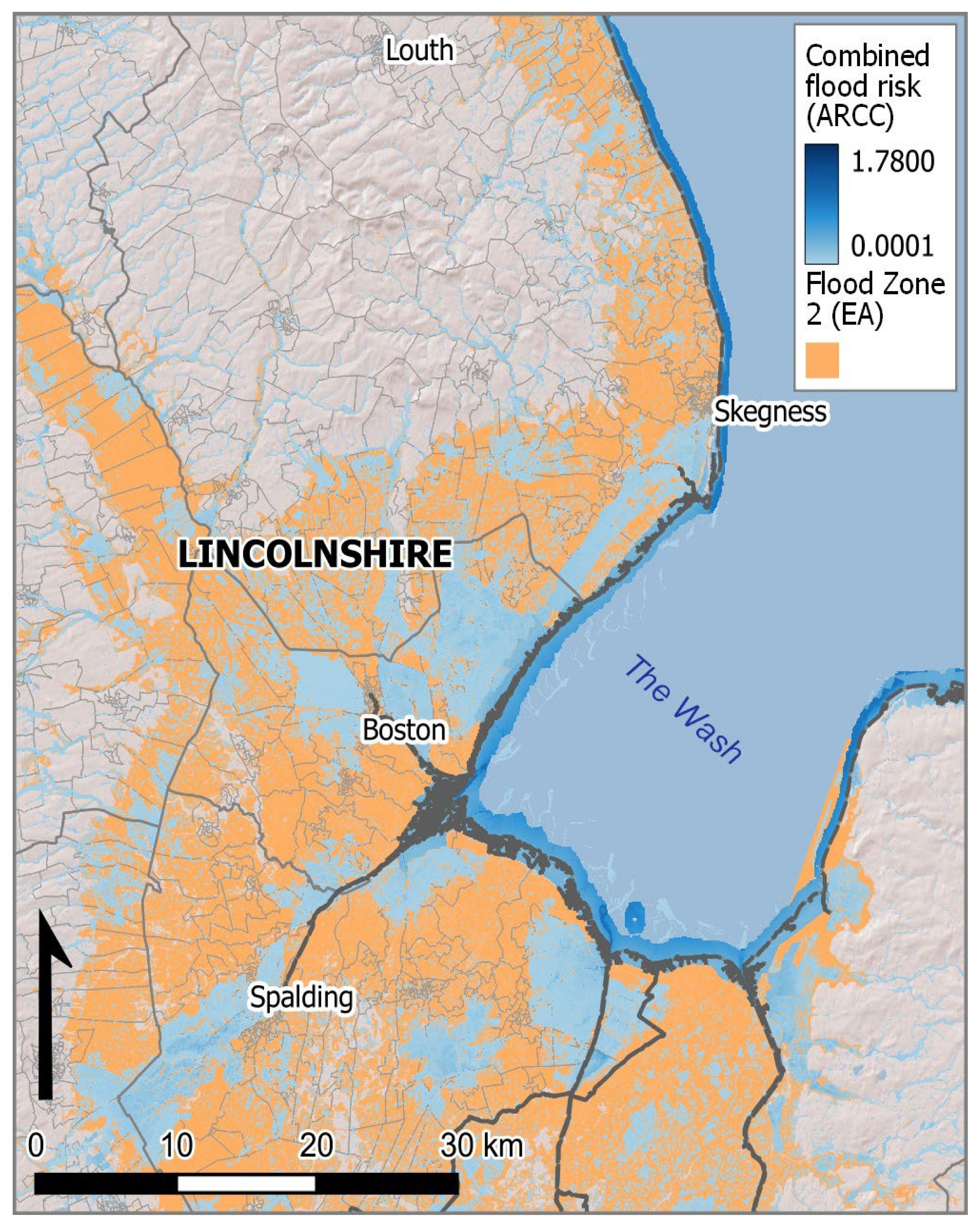
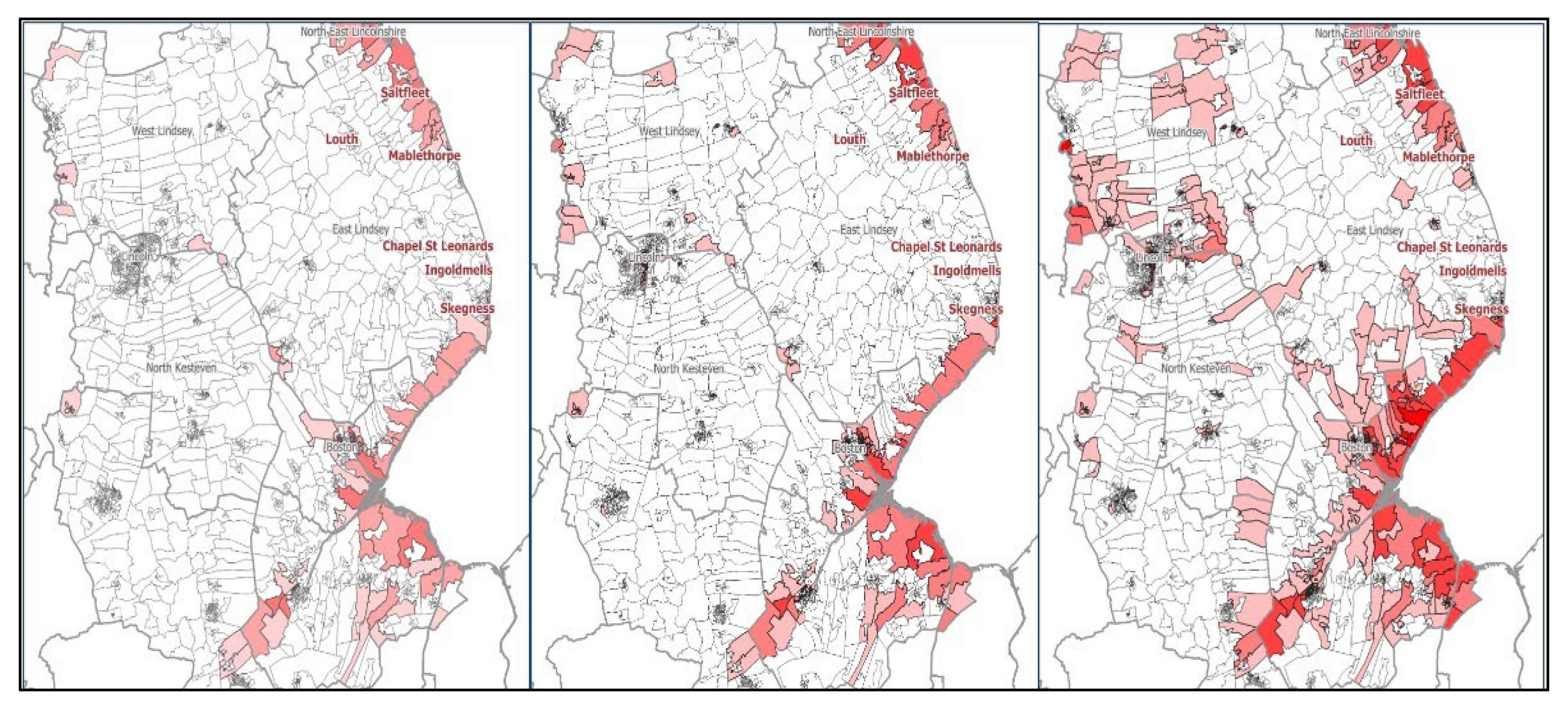
The framework (Figure 5) integrates a physical event system (Figure 10) and a multidimensional social data composite, visualised through GIS software (QGIS 3.28 Firenze) as compound hazard-exposure maps (Figure 11). These hydraulic and climate-scenario modelling processes constitute the simulation-analysis component of ARRCC-L, providing an empirical means of testing framework performance under multiple hazard and exposure conditions. Its physical event system employs a climate-conditioned catastrophe risk model (Figure 6) for UK pluvial, fluvial, and coastal flooding under historical, current, and future scenarios [9]. Region-specific hazard layers combine return period intervals with climate scenarios, while socio-cultural data and census information are incorporated to assess exposure and vulnerability indicators (Figure 10).
The physical system is built on the LISFLOOD-FP hydraulic code [74,75] using 2D modelling over DEFRA LiDAR data at 2 m resolution [76]. Fluvial modelling incorporates 1D river channels identified via UK Ordnance Survey data, with channel shapes assumed to be rectangular and their dimensions optimised for simulated flows [77,78]. Levee detection algorithms [79] and flood defences [80] further enhance the model, although structural deterioration analysis is not the system’s focus.
Boundary conditions derive from a Regionalised Flood Frequency Analysis (RFFA), integrating rainfall intensity data [81], coastal water levels [82], and historical gauged flows [83]. Baseline inputs reflect an extreme value distribution from 1960 to present for fluvial and coastal events and 1990–2014 for pluvial events. Mean sea levels are detrended to 2018 values, with historic averages linked to 0.6 °C warming above pre-industrial levels ([84], Volume 9, p. 8).
The resulting flood maps illustrate the average conditions since 1960 but account for variations tied to anthropogenic climate change and intensified extreme precipitation ([85], Volume 9, p. 3). These outputs form a critical evidence base for understanding and addressing evolving flood risks. The following section presents the outputs generated by the ARRCC-L framework, including flood-exposure maps and vulnerability composites, and evaluates their implications for long-term spatial planning and resilience-building in Lincolnshire.
The resulting flood maps illustrate the average conditions since 1960 but account for variations tied to anthropogenic climate change and intensified extreme precipitation. These outputs form a critical evidence base for understanding and addressing evolving flood risks. By integrating climate-driven data into both hazard modelling and vulnerability assessment, the ARRCC-L framework delivers a dynamic, context-sensitive tool for understanding compound flood risks and supporting regional adaptation. Unlike standardised methodologies [86], this system embeds multidimensional datasets, including scaled projections, stochastic modelling outputs, and deprivation metrics, into hydrodynamic simulation and spatial mapping processes. This integration enables tailored insights into the socio-environmental impacts of climate change and provides a robust foundation for adaptive policy and spatial planning.
Lincolnshire’s selection as the testbed for ARRCC-L is deliberate: the region exhibits a convergence of dynamics: coastal exposure, engineered flood defences, rural isolation, and socio-economic deprivation, which are mirrored across many low-lying and climate-sensitive regions in the UK and globally. By applying ARRCC-L to this setting, the framework captures scalable insights into hazard-vulnerability interactions and adaptation gaps that often emerge across broader regional planning levels. These insights are transferable to other contexts where fragmented evidence bases, and siloed infrastructure responses have hindered integrated resilience strategies. To enhance the reproducibility of this framework, the skeleton geospatial and hydraulic workflows will be scripted in QGIS using Python 3.10 and versioned via Git. Once refined and finalised, the processing steps, model parameter files (e.g., RCP-driven boundary conditions) and result-generation scripts will be published in an open GitHub repository, enabling independent replication or adaptation in other regions. The following section presents the research outputs from these workflows, including spatialised flood-exposure maps, vulnerability composites, and hazard-return assessments, and evaluates their implications for long-term resilience strategies in Lincolnshire, while also extracting transferable insights applicable to other regions exhibiting similar compound risk profiles.

3.2. Climate Change Scenario Incorporation

The ARRCC-L framework aims to optimise regional prosperity against climate change over the next century. Lincolnshire’s heavily engineered physical landscape, negative relief, and proximity to the North Sea marine basin present significant vulnerabilities to climate-driven environmental impacts. Social vulnerability, identified via the multidimensional deprivation index [87,88], aligns with historical development patterns near waterways and coastal areas. To address these complex socio-environmental dynamics, the approach highlights the interplay between physical events and social factors, including non-linear possibilities from climate variation.
Climate scenarios in the ARRCC-L framework rely on a change factor methodology [9,21], using data from the Met Office UKCP18 project. Projections of extreme precipitation extend from the present day to 2070, with focus points in 2030 and 2050, and median extrapolations up to 2100+ (Figure 6). Flood return periods incorporate these projections within the hydrodynamic model (Figure 7, Figure 8, Figure 9, Figure 10 and Figure 11). Coastal sea level rise estimates, derived from UK tide gauge data, reflect possible scenarios at various horizons [21], while historical records from NRFA and the FEH regionalisation method calculate index flows. These index flows translate into flood probabilities [89,90] adjusted for recent and future boundary conditions (2020, 2030, 2050, and 2070).
Unlike standardised methodologies [86], this approach provides a dynamic, region-specific integration of physical and social datasets to account for local environmental and socio-economic conditions. By embedding multidimensional datasets and scaled projections into hydrodynamic modelling, the ARRCC-L framework offers a nuanced understanding of compound risks, bridging the gap between theoretical modelling and practical application. This level of integration ensures tailored, actionable insights for adaptation strategies.
Storm surge projections from UKCP18 remain stable, following a linear pattern of occurrence based on gauged tidal data. Hazard footprints are generated through stochastic modelling combined with conditional exceedance statistical methods, producing outputs that illustrate hazard severity across historical extents (Figure 7, Figure 8 and Figure 9). By integrating these climate-driven datasets within the ARRCC-L framework, the system generates regionally sensitive insights that inform adaptive strategies to mitigate flood risks while addressing structural and socio-economic vulnerabilities. The evaluation of this pipeline within the Lincolnshire case study demonstrates its broader applicability, highlighting a transferable workflow and scalable methodology. This transition from raw data to policy-relevant insight establishes a foundation for long-term resilience planning in Lincolnshire, while also extracting transferable strategies applicable to other regions seeking equitable adaptation.

4. Results and Evaluation

Building on regional insights, this section situates Lincolnshire’s resilience planning within the wider national context through three key intervention strategies which were prioritised to guide adaptation and resilience-building efforts under a changing climate and regional environmental challenges. The ARRCC-L modelling framework (Figure 5) reflects this collective vision for the Lincolnshire region, developed through strategic partnerships (intervention point 2; see Section 3 Methods) to deliver a fully integrated flood risk assessment, management, and adaptation framework (intervention point 1), informed by a comprehensive body of flood data (intervention point 3). Unlike the Humber 2100+ strategy proximal to the north of the Lincolnshire region, which prioritises engineered flood defences and tidal surge barriers, ARRCC-L emphasises integrated socio-environmental vulnerability mapping and stakeholder-driven adaptation processes. By leveraging the following key inputs and outputs:
  • Coastal Processes: Locations and estimates of ongoing coastal dynamics derived from satellite imagery.
  • Settlement Flood Risk: Environment Agency data combined with ‘what if’ modelling to project future flood extents under climate variability.
  • Maps of the built environment, to help with the identification of future hazard liability in key areas of Lincolnshire.
The Wash Estuary Management Plan, proximal to the south of the Lincolnshire region focuses on habitat conservation and intertidal buffering, whereas ARRCC-L uniquely synthesises high-resolution flood-risk modelling with multidimensional deprivation indices through a simulation-analysis approach that tests framework performance under varying hazard and exposure conditions, and uses these outputs to inform equitable resilience planning via:
  • Built Environment Mapping: Identification of future hazard liabilities in key areas through detailed maps of the built environment. Socio-Economic Benefits: Outputs based on median event likelihoods extrapolated from historical records to depict areas affected, or unaffected, by current and future climate variability, enabling insights into potential growth opportunities.
  • Socio-Economic and Health Integration: Flood maps intersected with socio-economic and health data to highlight areas for continued growth or relocation based on informed, impact-minimising strategies.
  • Scalable Data Integration: Incorporation of health, social, and economic data at multiple operational scales, enabling targeted interventions in high-priority areas through strategic partnerships and socio-environmental analysis.
Together, these components form an initial framework to enhance the resilience and prosperity of the Lincolnshire coast. At its core, the system utilises a GIS-based risk platform combining hazard footprints with vulnerability characteristics (Figure 7, Figure 8, Figure 9, Figure 10, Figure 11 and Figure 12). The flood-exposure and deprivation composites (Figure 9, Figure 10, Figure 11 and Figure 12) will directly reflect the documented workflow: each scenario map is generated by rerunning the versioned scripts against the corresponding climate-factor files. Future users will be able to reproduce these outputs via the repository’s ‘run_all_scenarios.sh’ pipeline.
Looking ahead, stakeholders can use the versioned ‘run_all_scenarios.sh’ pipeline to test custom RCP timelines and integrate updated climate datasets as they become available, ensuring the framework stays agile and relevant. At the same time, Lincolnshire, like many regions worldwide, faces growing climate pressures. The 1.5 °C threshold under RCP 2.6 is likely to be exceeded this decade, and up to eight per cent of farmland could become unusable because of heat stress, erratic rainfall and soil salinisation from coastal inundation [92,93,94]. Embedding these dynamic projections within the ARRCC-L framework allows planners to work iteratively with end users to refine spatial adaptation strategies and bolster resilience across rural and coastal communities. The following section of this paper presents the system outputs—flood exposure maps, vulnerability composites and hazard-return assessments—and evaluates their implications for Lincolnshire’s long-term resilience strategy while also highlighting insights transferable to other exposed regions.
Although the specific impacts and mitigation strategies are beyond the scope of this paper, the ARRCC-L framework outputs provide a vital framework for future planning in Lincolnshire. They offer valuable insights into potential dynamics under a changing climate. A key consideration for the county includes plans for inland areas that may face flooding or reduced rainfall, as these regions are crucial to Lincolnshire’s agricultural economy [92,95].
Validating the ARRCC-L framework is a critical step in advancing a shared understanding of the region’s physical dynamics.
By integrating United Kingdom Climate Project (UKCP18) data for Representative Concentration Pathways (RCPs), the system demonstrates how projected changes will influence the climatological and meteorological interface between human and natural environments (Figure 7, Figure 10, Figure 11 and Figure 12). However, caution is warranted, as ARRCC-L outputs depend on attributing specific RCP scenarios to associated physical dynamics, which can vary significantly. For example, projecting a 1-in-50-year flood under an RCP 2.6 scenario highlights the challenges of accounting for this variance.
A significant challenge for the ARRCC-L framework has been navigating the obfuscated documentation in both peer-reviewed literature and accessible reports. Poor reporting of validation studies [96,97,98,99] has complicated efforts to efficiently capture effective future strategies, hindering uptake and participation across governance and management levels. Bates et al. [12] echo these frustrations, noting the “considerable detective work required” to uncover the methods and datasets underpinning existing UK flood risk models, despite their use in critical planning efforts like the UK’s Climate Change Risk Assessment [100] and national flood defence investment strategies [101].
This lack of transparency has stymied robust decision-making at optimal intervention points between affected systems, particularly from scientific and planning standpoints. For ARRCC-L, technical challenges have included limitations in available datasets, which primarily represent a narrow range of flood return periods. Furthermore, comparable studies often overlook spatial correlations in flood hazards [102,103,104] or fail to adequately account for the impacts of climate change [105]. To address these gaps, ARRCC-L offers an applied methodology integrating available data to generate future projections, capturing the nuanced socio-environmental interactions from micro- to macro-scale for the region. This innovative approach enhances understanding of the region’s flood risk dynamics while establishing routes for informed climate adaptation strategies.

4.1. Validation and Long-Term Considerations

Validation of the ARRCC-L system has been achieved through alignment between its projected outputs and Environment Agency (EA) flood zone maps (Figure 8), as well as broad consensus on key metrics like expected flooded properties at critical climate horizons (Table 1). ARRCC-L’s physical event system provides standardised outputs, isolating individual flood event types (fluvial, pluvial, etc.) or combining them to illustrate compound impacts at specific time horizons, coupled with UKCP18 climate projections.
A pressing concern is the structural dynamics of Lincolnshire’s sea and flood defences, which have been central to debates on future planning [62,69,106]. Further compounding the region’s risks are longstanding proposals for a geological deposit facility (GDF) for nuclear waste near two vulnerable northern communities, intended to support national aspirations for nuclear expansion [107]. Managing such facilities under rising sea levels poses significant challenges [108] and fuels regional suspicion toward large-scale change [109]. If approved, these plans would require meticulous evaluation of long-term risks associated with placing a GDF in an area already exposed to compounded flood risks [110].

4.2. Defence Strategy and Public Perception

Before the ARRCC-L framework, collaborative partners proposed rethinking Lincolnshire’s coastal defence strategy, shifting from Hold-the-Line (HtL) to Managed Realignment (MR). This shift would enable a more adaptive evolution of the shoreline in response to changing coastal processes [42]. However, regional studies highlight strong public resistance, with communities demanding earlier consultations and clearer explanations for such changes, rooted in historical scepticism of costly environmental projects.
Historical studies [96,111] suggest that local populations often do not perceive catastrophic flooding as imminent within their lifetimes, posing direct challenges to resilience building strategies, particularly building support for large-scale restructuring of sea and river defences. While near-term impacts would mainly affect coastal inhabitants, the inland area’s heavily engineered water systems (Figure 2 and Figure 3) and farming communities also face immediate and longer-term risks from climate-driven increases in coastal flood activity and compounded flooding [23,95]. These dynamics underscore the urgency of balanced defence and adaptation strategies that address both coastal and inland vulnerabilities from the viewpoint of those who are, and will be, impacted.
ARRCC-L offers a practical step toward overcoming these perception and strategy challenges. It integrates high-resolution flood-risk modelling with socio-economic and health data in a transparent, stakeholder-driven process. By overlaying defence options such as managed realignment scenarios with local vulnerability indices and visualising outcomes through interactive maps, the framework builds public understanding of trade-offs and establishes the legitimacy of adaptive defence policies. This approach fosters community trust and supports the long-term adoption of climate-informed coastal management.

5. Conclusions

This research presents a practical regionalised framework, ARRCC-L, for navigating resilience and sustainability under environmental stressors such as floods and droughts. Flexible across RCP and SSP scenarios, ARRCC-L bridges knowledge gaps among diverse stakeholders and informs development plans for coastal communities. Although designed around Lincolnshire’s specific socio-environmental context, its principles and methodologies apply to similar regions at local, national and international scales.
Regionally, ARRCC-L addresses Lincolnshire’s key vulnerabilities of coastal inundation, inland flood propagation and a climate-sensitive agricultural sector. By integrating physical, social and environmental datasets, the framework provides local authorities, community groups and other stakeholders with clear pathways to assess risk, co-design mitigation measures and seize opportunities for sustainable growth.
At the national level, ARRCC-L enhances climate adaptation strategies for coastal and rural areas by improving risk evaluation and response methods. Its compatibility with existing initiatives such as the Humber and Wash programmes and the UK Climate Change Risk Assessment demonstrates its potential to guide targeted investment in flood defences and inform policy priorities.
Globally, the ARRCC-L framework offers a transferable model for regions confronting rising sea levels, socio-economic disparities and agro-climatic fragility. By combining historical observations with future projections, it delivers a reproducible methodology for lowland and coastal landscapes from Europe to other climate-sensitive regions worldwide.

5.1. Limitations

We acknowledge several constraints in the current ARRCC-L implementation. Reliance on 2 m LiDAR resolution may obscure micro-topographic features, flood defence performance is assumed static, and the choice of RCP forcing datasets could influence scenario outcomes. While the simulation analysis provides a robust initial test of ARRCC-L, further empirical application across varied socio-environmental contexts would enhance comparative insight.

5.2. Future Research

Future work will extend ARRCC-L to include:
  • dynamic breach and defence-fragility modelling, incorporating a targeted sea-level breach-fragility sensitivity test exploring ± 10 cm perturbations.
  • integration of real-time sensor data for event-driven calibration of model parameters.
  • detailed cost–benefit analyses of alternative adaptation pathways.
  • deployment of stakeholder surveys to assess the socio-political feasibility and uptake of the proposed measures.

5.3. Recommendations for Planners

  • Prioritise composite vulnerability mapping to direct flood defence upgrades towards the most socially and economically vulnerable areas.
  • Adopt open-source, versioned workflows to promote transparency and enable cross-region comparability of adaptation assessments.
  • Embed ARRCC-L outputs within Local Plans and the UK’s climate risk frameworks to align strategic investment with evidence-based adaptation needs.
Computationally, further refinements could advance ARRCC’s capacity to simulate structural dynamics such as defence fragility and breach scenarios and to model population relocation and infrastructure resilience. Such enhancements would deepen understanding of socio-environmental interactions and broaden ARRCC’s relevance to global adaptation agendas. The current outputs already provide vital intelligence on Lincolnshire’s water variability and flood susceptibility, demonstrating how a flexible framework can be tailored to different governance levels and socio-economic contexts.
Ultimately, by answering our central question of how a reproducible multi-scenario framework can inform equitable adaptation, ARRCC underscores the value of transparent, practical approaches that unite governance tiers, practitioners and communities. Whether applied locally, nationally or internationally, it offers a robust foundation for managing uncertainty and guiding sustainable futures under climate change. Once finalised, all data, model scripts and workflow protocols will be made publicly available, enabling policymakers, practitioners, and researchers to reproduce, scrutinise and extend this case study across diverse coastal and rural settings.

Author Contributions

Conceptualization, T.O., M.G.M. and C.T.; Methodology, T.O. and D.C.; Software, T.O. and D.C.; Validation, T.O. and D.C.; Formal analysis, T.O. and D.C.; Investigation, T.O. and D.C.; Resources, T.O., D.C. and M.G.M.; Data curation, T.O. and D.C.; Writing—original draft, T.O. and M.G.M.; Writing—review & editing, T.O., M.G.M. and C.T.; Visualization, D.C.; Supervision, T.O. and M.G.M.; Funding acquisition, M.G.M. All authors have read and agreed to the published version of the manuscript.

Funding

This research received no external funding. The APC for this publication was provided by the University of Salford library.

Institutional Review Board Statement

Not applicable.

Informed Consent Statement

Not applicable.

Data Availability Statement

The data that supports the findings of this study are available from the corresponding author upon reasonable request. Global Flood Model layers are available upon reasonable request from Fathom (https://www.fathom.global/).

Acknowledgments

This paper arises from the ‘The Adaptive and Resilient Rural-Coastal Communities in Lincolnshire, UK (ARRCC-L) Project’, a partnership between the Environment Agency, University of Lincoln, Lincolnshire County Council and East Lindsey and Boston District Councils. The authors also extend sincere thanks to colleagues in the Hydrology Group at the University of Bristol and at Fathom for access to the Global Flood Model (GFM) for the UK.

Conflicts of Interest

The authors declare no conflicts of interest.

Abbreviations

AcronymFull termDescription
ARRCC-LAdaptation and Resilience for Rural-Coastal Communities in LincolnshireFramework integrating high-resolution flood-risk modelling with socio-economic and health data to guide stakeholder-driven adaptation
HtLHold the LineCoastal defence strategy focused on maintaining the existing shoreline position with fixed sea- and river-defences
MRManaged RealignmentDefence approach that allows controlled retreat so the shoreline can evolve naturally with changing coastal processes
RCPRepresentative Concentration PathwayGreenhouse gas concentration trajectories used in climate modelling
SSPShared Socioeconomic PathwayScenarios of projected societal changes, including demographics and economics, used alongside RCPs
FCERMFlood and Coastal Erosion Risk ManagementUK-wide framework for assessing and managing flood and coastal erosion risks

References

  1. Parry, L.; Davies, G.; Almeida, O.; Frausin, G.; de Moraés, A.; Rivero, S.; Filizola, N.; Torres, P. Social vulnerability to climatic shocks is shaped by urban accessibility. Ann. Am. Assoc. Geogr. 2018, 108, 125–143. [Google Scholar] [CrossRef]
  2. Li, A.; Toll, M.; Bentley, R. Mapping social vulnerability indicators to understand the health impacts of climate change: A scoping review. Lancet Planet. Health 2023, 7, e925–e937. [Google Scholar] [CrossRef]
  3. Ngcamu, B.S. Climate change effects on vulnerable populations in the Global South: A systematic review. Nat. Hazards 2023, 118, 977–991. [Google Scholar] [CrossRef]
  4. Green, J.; Haigh, I.D.; Quinn, N.; Neal, J.; Wahl, T.; Wood, M.; Eilander, D.; de Ruiter, M.; Ward, P.; Camus, P. Review article: A comprehensive review of compound flooding literature with a focus on coastal and estuarine regions. Nat. Hazards Earth Syst. Sci. 2025, 25, 747–816. [Google Scholar] [CrossRef]
  5. Holling, C.S. Resilience and stability of ecological systems. Annu. Rev. Ecol. Syst. 1973, 4, 1–23. [Google Scholar] [CrossRef]
  6. Folke, C. Resilience (republished). Ecol. Soc. 2016, 21, 44. [Google Scholar] [CrossRef]
  7. Meerow, S.; Newell, J.P.; Stults, M. Defining urban resilience: A review. Landsc. Urban Plan. 2016, 147, 38–49. [Google Scholar] [CrossRef]
  8. Oppenheimer, M.; Glavovic, B.; Hinkel, J.; van de Wal, R.; Magnan, A.K.; Abd-Elgawad, A.; Cai, R.; Cifuentes-Jara, M.; Deconto, R.M.; Ghosh, T.; et al. Sea level rise and implications for low lying islands, coasts and communities. In IPCC Special Report on the Ocean and Cryosphere in a Changing Climate; Cambridge University Press: Cambridge, UK, 2019. [Google Scholar]
  9. Zanotti, L.; Ma, Z.; Johnson, J.L.; Johnson, D.R.; Yu, D.J.; Burnham, M.; Carothers, C. Sustainability, resilience, adaptation, and transformation: Tensions and plural approaches. Ecol. Soc. 2020, 25, 4. [Google Scholar] [CrossRef]
  10. Evans, L.; Blythe, J.; Bennett, N.; Brown, K.; Turner, R.A.; Baggio, J.A.; Baker, D.; Ban, N.C.; Brun, V.; Claudet, J. Triple exposure: Reducing negative impacts of climate change, blue growth and conservation on coastal communities. One Earth 2023, 6, 118–130. [Google Scholar] [CrossRef]
  11. Galasso, C.; McCloskey, J.; Pelling, M.; Hope, M.; Bean, C.; Cremen, G.; Guragain, R.; Hancilar, U.; Menoscal, J.; Mwelu, K.; et al. Risk-based, Pro-poor Urban Design and Planning for Tomorrow’s Cities. Int. J. Disaster Risk Reduct. 2021, 58, 102158. [Google Scholar] [CrossRef]
  12. Bates, P.D.; Savage, J.; Wing, O.; Quinn, N.; Sampson, C.; Neal, J.; Smith, A. A climate-conditioned catastrophe risk model for UK flooding. EGUsphere 2022, 1–29. [Google Scholar] [CrossRef]
  13. Joseph Rowntree Foundation. UK Poverty Statistics. 2022. Available online: https://www.jrf.org.uk/data (accessed on 1 August 2022).
  14. Citizens Advice. CA Cost of Living Data Dashboard|Flourish. 2022. Available online: https://www.citizensadvice.org.uk/policy/cost-of-living/data/ (accessed on 15 August 2022).
  15. Ministry of Housing, Communities & Local Government. English Indices of Deprivation. 2019. Available online: https://www.gov.uk/government/statistics/english-indices-of-deprivation-2019 (accessed on 18 August 2022).
  16. Green, M.A.; Daras, K.; Davies, A.; Barr, B.; Singleton, A. Developing an openly accessible multi-dimensional small area index of ‘Access to Healthy Assets and Hazards’ for Great Britain, 2016. Health Place 2018, 54, 11–19. [Google Scholar] [CrossRef]
  17. Cairns, J.M.; Curtis, S.E.; Bambra, C. Defying deprivation: A cross-sectional analysis of area level health resilience in England. Health Place 2012, 18, 928–933. [Google Scholar] [CrossRef]
  18. Cairns-Nagi, J.M.; Bambra, C. Defying the odds: A mixed-methods study of health resilience in deprived areas of England. Soc. Sci. Med. 2013, 91, 229–237. [Google Scholar] [CrossRef]
  19. Andrew, M.; Hendry, A.; Bunce, A. Nurturing Resilient and Compassionate Communities in Scotland. Int. J. Integr. Care 2022, 22, 149. [Google Scholar] [CrossRef]
  20. Khan, N. The cost of living crisis: How can we tackle fuel poverty and food insecurity in practice? Br. J. Gen. Pract. 2022, 72, 330–331. [Google Scholar] [CrossRef]
  21. Kopp, R.E.; Horton, R.M.; Little, C.M.; Mitrovica, J.X.; Oppenheimer, M.; Rasmussen, D.J.; Strauss, B.H.; Tebaldi, C. Probabilistic 21st and 22nd century sea-level projections at a global network of tide-gauge sites. Earth’s Future 2014, 2, 383–406. [Google Scholar] [CrossRef]
  22. Depledge, M.H.; Lovell, R.; Wheeler, B.W.; Morrissey, K.M.; White, M.; Fleming, L.E. Future of the Sea: Health and Wellbeing of Coastal Communities; Government Office of Science: London, UK, 2017. [Google Scholar]
  23. Hendry, A.; Haigh, I.D.; Nicholls, R.J.; Winter, H.; Neal, R.; Wahl, T.; Joly-Laugel, A.; Darby, S.E. Assessing the characteristics and drivers of compound flooding events around the UK coast. Hydrol. Earth Syst. Sci. 2019, 23, 3117–3139. [Google Scholar] [CrossRef]
  24. Sinay, L.; Carter, R.W. Climate change adaptation options for coastal communities and local governments. Climate 2020, 8, 7. [Google Scholar] [CrossRef]
  25. Winn, P.; Laws, H.; Marshall, L.; Todd, H.; Normandale, D.; Hopton, L.; Brown, C.; Connell, J. Developing a New Humber Flood Risk Management Strategy to Support People, Business and the Environment. In Coastal Management 2019: Joining Forces to Shape Our Future Coasts; ICE Publishing: London, UK, 2020; pp. 29–42. [Google Scholar]
  26. Lonsdale, J.A.; Leach, C.; Parsons, D.; Barkwith, A.; Manson, S.; Elliott, M. Managing estuaries under a changing climate: A case study of the Humber Estuary, UK. Environ. Sci. Policy 2022, 134, 75–84. [Google Scholar] [CrossRef]
  27. Environment Agency. The Humber Flood Risk Management Strategy. 2008. Available online: https://www.gov.uk (accessed on 15 August 2022).
  28. Environment Agency. The Wash East Coastal Management Strategy. 2014. Available online: https://www.gov.uk (accessed on 15 August 2022).
  29. Eriksen, S.H.; O’brien, K. Vulnerability, poverty and the need for sustainable adaptation measures. Clim. Policy 2007, 7, 337–352. [Google Scholar] [CrossRef]
  30. Eriksen, S.; Schipper, E.L.F.; Scoville-Simonds, M.; Vincent, K.; Adam, H.N.; Brooks, N.; Harding, B.; Khatri, D.; Lenaerts, L.; Liverman, D.; et al. Adaptation interventions and their effect on vulnerability in developing countries: Help, hindrance, or irrelevance? World Dev. 2021, 141, 105383. [Google Scholar] [CrossRef]
  31. Tamasiga, P.; Mogomotsi, P.K.; Onyeaka, H.; Mogomotsi, G.E. Amplifying climate resilience: The impact of social protection, social cohesion, and social capital on public support for climate change action. Sustain. Environ. 2024, 10, 2361568. [Google Scholar] [CrossRef]
  32. Sagala, S.; Azhari, D.; Nailah, N.; Vicri, R.N.; Paramitasari, D.; Herdiansyah, A.R.; Patricia, C. Transformative Participation in Inclusive Disaster Risk Reduction. In Oxford Research Encyclopedia of Natural Hazard Science; Oxford University Press: Oxford, UK, 2024. [Google Scholar]
  33. Bang, H.N.; Burton, N.C. Contemporary flood risk perceptions in England: Implications for flood risk management foresight. Clim. Risk Manag. 2021, 32, 100317. [Google Scholar] [CrossRef]
  34. Wadey, M.P.; Haigh, I.D.; Nicholls, R.J.; Brown, J.M.; Horsburgh, K.; Carroll, B.; Gallop, S.L.; Mason, T.; Bradshaw, E. A comparison of the 31 January–1 February 1953 and 5–6 December 2013 coastal flood events around the UK. Front. Mar. Sci. 2015, 2, 84. [Google Scholar] [CrossRef]
  35. Rouse, A.E.; Nunn, R.; Cali, M.; Hesk, P. Living with the legacy of an artificially created coastline in Lincolnshire, England. In Coastal Management 2019: Joining Forces to Shape Our Future Coasts; ICE Publishing: London, UK, 2020; pp. 301–316. [Google Scholar]
  36. Camus, P.; Haigh, I.D.; Quinn, N.; Wahl, T.; Benson, T.; Gouldby, B.; Nasr, A.A.; Rashid, M.M.; Enríquez, A.R.; Darby, S.E.; et al. Tracking the spatial footprints of extreme storm surges around the coastline of the UK and Ireland. Weather. Clim. Extrem. 2024, 44, 100662. [Google Scholar] [CrossRef]
  37. Sefton, C.; Muchan, K.; Parry, S.; Matthews, B.; Barker, L.J.; Turner, S.; Hannaford, J. The 2019/2020 floods in the UK: A hydrological appraisal. Weather 2021, 76, 378–384. [Google Scholar] [CrossRef]
  38. Penning-Rowsell, E.C. Comparing the scale of modelled and recorded current flood risk: Results from England. J. Flood Risk Manag. 2021, 14, e12685. [Google Scholar] [CrossRef]
  39. Hogarth, T.; Owen, D.; Green, A.; Samuel, M.; de Hoyos, M.; Gambin, L. East Lindsey Coastal Zone Skills Audit. Report Prepared by the Warwick Institute for Employment Research for East Midlands Development Agency, Coventry. Inogen Environmental Alliance (IEA) Flood Risk and Climate Change: England Flood Planners Must Prepare for the Worst? GRESB Website 2019. 2010. Available online: https://gresb.com/flood-risk-climate-change-england-flood-planners-must-prepare-worst/ (accessed on 1 March 2022).
  40. Dolan, A.H.; Walker, I.J. Understanding vulnerability of coastal communities to climate change related risks. J. Coast. Res. 2006, 3, 1316–1323. [Google Scholar]
  41. Sutton-Grier, A.E.; Wowk, K.; Bamford, H. Future of our coasts: The potential for natural and hybrid infrastructure to enhance the resilience of our coastal communities, economies and ecosystems. Environ. Sci. Policy 2015, 51, 137–148. [Google Scholar] [CrossRef]
  42. Sayers, P.; Moss, C.; Carr, S.; Payo Garcia, A. Responding to climate change around England’s coast: The scale of the transformational challenge. Ocean. Coast. Manag. 2022, 225, 106187. [Google Scholar] [CrossRef]
  43. Boon, H.; Millar, J.; Lake, D.; Cottrell, A.; King, D. Recovery from Disaster: Resilience, Adaptability and Perceptions of Climate Change; National Climate Change Adaptation Research Facility: Southport, Australia, 2012. [Google Scholar]
  44. Heinzlef, C.; Robert, B.; Hémond, Y.; Serre, D. Operating urban resilience strategies to face climate change and associated risks: Some advances from theory to application in Canada and France. Cities 2020, 104, 102762. [Google Scholar] [CrossRef]
  45. Tribbia, J.; Moser, S.C. More than information: What coastal managers need to plan for climate change. Environ. Sci. Policy 2008, 11, 315–328. [Google Scholar] [CrossRef]
  46. Hallegatte, S. Strategies to adapt to an uncertain climate change. Glob. Environ. Change 2009, 19, 240–247. [Google Scholar] [CrossRef]
  47. Wilby, R.L.; Keenan, R. Adapting to flood risk under climate change. Prog. Phys. Geogr. 2012, 36, 348–378. [Google Scholar] [CrossRef]
  48. Ledoux, L.; Cornell, S.; O’Riordan, T.; Harvey, R.; Banyard, L. Towards sustainable flood and coastal management: Identifying drivers of, and obstacles to, managed realignment. Land Use Policy 2005, 22, 129–144. [Google Scholar] [CrossRef]
  49. DEFRA. Shoreline management plan guidance. In Volume 1: Aims and Requirements; DEFRA: London, UK, 2006. [Google Scholar]
  50. Fox, S.; Agyemang, F.; Hawker, L.; Neal, J. Integrating social vulnerability into high-resolution global flood risk mapping. Nat. Commun. 2024, 15, 3155. [Google Scholar] [CrossRef]
  51. Nicholls, R.J.; Lincke, D.; Hinkel, J.; Brown, S.; Vafeidis, A.T.; Meyssignac, B.; Hanson, S.E.; Merkens, J.L.; Fang, J. A global analysis of subsidence, relative sea-level change and coastal flood exposure. Nat. Clim. Change 2021, 11, 338–342. [Google Scholar] [CrossRef]
  52. Maes, J.; Teller, A.; Erhard, M.; Liquete, C.; Braat, L.; Berry, P.; Egoh, B.; Puydarrieux, P.; Fiorina, F.; Santos, F.; et al. Mapping and Assessment of Ecosystems and their Services: An Analytical Framework for Ecosystem Assessments Under Action 5 of the EU Biodiversity Strategy to 2020; Publications office of the European Union: Luxembourg, 2013. [Google Scholar]
  53. Dyball, R.; Newell, B. Understanding Human Ecology: A Systems Approach to Sustainability; Taylor & Francis: Abingdon, UK, 2023. [Google Scholar]
  54. O’Shea, T.; Bates, P.; Neal, J. Testing the impact of direct and indirect flood warnings on population behaviour using an agent-based model. Nat. Hazards Earth Syst. Sci. 2020, 20, 2281–2305. [Google Scholar] [CrossRef]
  55. Warner, J.; Edelenbos, J.; van Buuren, A. Making space for the river: Governance challenges. In Making Space for the River: Governance Experiences with Multifunctional River Flood Management in the US and Europe; IWA Publishing: London, UK, 2012; pp. 1–14. [Google Scholar]
  56. Zsamboky, M.; Fernández-Bilbao, A.; Smith, D.; Knight, J.; Allan, J. Impacts of Climate Change on Disadvantaged UK Coastal Communities; Joseph Rowntree Foundation: York, UK, 2011; pp. 1–63. [Google Scholar]
  57. Molenveld, A.; van Buuren, A. Flood risk and resilience in the Netherlands: In search of an adaptive governance approach. Water 2019, 11, 2563. [Google Scholar] [CrossRef]
  58. Hegger, D.; Alexander, M.; Raadgever, T.; Priest, S.; Bruzzone, S. Shaping flood risk governance through science-policy interfaces: Insights from England, France and the Netherlands. Environ. Sci. Policy 2020, 106, 157–165. [Google Scholar] [CrossRef]
  59. Singh, M.; Sinha, R.; Tandon, S.K. Geomorphic connectivity and its application for understanding landscape complexities: A focus on the hydro-geomorphic systems of India. Earth Surf. Process. Landf. 2021, 46, 110–130. [Google Scholar] [CrossRef]
  60. Ray, J.; Coulling, E.; Evans, S.Y.; Spink, K. Developing a practical tool for coastal flood forecasting and warning. In Innovative Coastal Zone Management: Sustainable Engineering for a Dynamic Coast; ICE Publishing: London, UK, 2012; pp. 171–180. [Google Scholar]
  61. Mills, A.K.; Ruggiero, P.; Bolte, J.P.; Serafin, K.A.; Lipiec, E. Quantifying uncertainty in exposure to coastal hazards associated with both climate change and adaptation strategies: A US pacific northwest alternative coastal futures analysis. Water 2021, 13, 545. [Google Scholar] [CrossRef]
  62. Priest, S.J. Why understanding behaviour matters for flood risk management? J. Flood Risk Manag. 2021, 14, e12724. [Google Scholar] [CrossRef]
  63. Bennett, N.J.; Dearden, P.; Murray, G.; Kadfak, A. The capacity to adapt? Communities in a changing climate, environment, and economy on the northern Andaman coast of Thailand. Ecol. Soc. 2014, 19, 5. [Google Scholar] [CrossRef]
  64. Cinner, J.E.; Adger, W.N.; Allison, E.H.; Barnes, M.L.; Brown, K.; Cohen, P.J.; Gelcich, S.; Hicks, C.C.; Hughes, T.P.; Lau, J.; et al. Building adaptive capacity to climate change in tropical coastal communities. Nat. Clim. Change 2018, 8, 117–123. [Google Scholar] [CrossRef]
  65. Alberts, A.; Baldacchino, G. Resilience and tourism in islands: Insights from the Caribbean. In Tourism and Resilience; CABI: Wallingford, UK, 2017; pp. 150–162. [Google Scholar]
  66. Emmins, N.; Leckie, C.; Munro, R.; Pragnell, M. Communities on the Edge: Assessing the Need for Levelling Up in England’s Coastal Authorities. 2023 Online Report. Available online: https://www.coastalcommunities.co.uk/knowledge-base/category/reports/communities-on-the-edge (accessed on 1 June 2023).
  67. Burgess, C.P.; Taylor, M.A.; Stephenson, T.; Mandal, A.; Powell, L. A macro-scale flood risk model for Jamaica with impact of climate variability. Nat. Hazards 2015, 78, 231–256. [Google Scholar] [CrossRef]
  68. Van Looy, K.; Wolter, C.; Jeschke, J.M.; Beisel, J.N.; Heger, T. Invasion wave patterns testify to the resilience of river systems. In Resilience and Riverine Landscapes; Elsevier: Amsterdam, The Netherlands, 2024; pp. 229–246. [Google Scholar]
  69. Rouse, A.; Campbell, D.; Scott, A.; Hunt, P.; Trewhella, S.; Hesk, P. Rising to climate challenges and opportunities in managing Lincolnshire’s coastline, UK. In Proceedings of the Institution of Civil Engineers-Civil Engineering; Thomas Telford Ltd.: London, UK, 2021; Volume 174, pp. 41–48. [Google Scholar]
  70. Oliver, T.H.; Bazaanah, P.; Da Costa, J.; Deka, N.; Dornelles, A.Z.; Greenwell, M.P.; Nagarajan, M.; Narasimhan, K.; Obuobie, E.; Osei, M.A.; et al. Empowering citizen-led adaptation to systemic climate change risks. Nat. Clim. Change 2023, 13, 671–678. [Google Scholar] [CrossRef]
  71. Sparkes, E.; Werners, S.E. Monitoring, evaluation and learning requirements for climate-resilient development pathways. Curr. Opin. Environ. Sustain. 2023, 64, 101329. [Google Scholar] [CrossRef]
  72. Office of National Statistics (ONS). Habitat Extent and Condition, Natural Capital, UK: 2022. 2022. Available online: https://www.ons.gov.uk/economy/environmentalaccounts/bulletins/habitatextentandconditionnaturalcapitaluk/2022 (accessed on 1 June 2023).
  73. Cremen, G.; Galasso, C.; McCloskey, J. Modelling and quantifying tomorrow’s risks from natural hazards. Sci. Total Environ. 2021, 817, 152552. [Google Scholar] [CrossRef] [PubMed]
  74. Yamazaki, D.; de Almeida, G.A.; Bates, P.D. Improving computational efficiency in global river models by implementing the local inertial flow equation and a vector-based river network map. Water Resour. Res. 2013, 49, 7221–7235. [Google Scholar] [CrossRef]
  75. Coulthard, T.J.; Neal, J.C.; Bates, P.D.; Ramirez, J.; de Almeida, G.A.; Hancock, G.R. Integrating the LISFLOOD-FP 2D hydrodynamic model with the CAESAR model: Implications for modelling landscape evolution. Earth Surf. Process. Landf. 2013, 38, 1897–1906. [Google Scholar] [CrossRef]
  76. DEFRA. Data Services Platform, LIDAR Composite 2020. 2020. Available online: https://environment.data.gov.uk/DefraDataDownload/?Mode=survey (accessed on 1 June 2023).
  77. Neal, J.; Keef, C.; Bates, P.; Beven, K.; Leedal, D. Probabilistic flood risk mapping including spatial dependence. Hydrol. Process. 2013, 27, 1349–1363. [Google Scholar] [CrossRef]
  78. Neal, J.; Hawker, L.; Savage, J.; Durand, M.; Bates, P.; Sampson, C. Estimating river channel bathymetry in large scale flood inundation models. Water Resour. Res. 2021, 57, e2020WR028301. [Google Scholar] [CrossRef]
  79. Wing, O.E.; Bates, P.D.; Neal, J.C.; Sampson, C.C.; Smith, A.M.; Quinn, N.; Shustikova, I.; Domeneghetti, A.; Gilles, D.W.; Goska, R.; et al. A new automated method for improved flood defense representation in large-scale hydraulic models. Water Resour. Res. 2019, 55, 11007–11034. [Google Scholar] [CrossRef]
  80. AIMS Spatial Flood Defences (Including Standardised Attributes). Available online: https://www.data.gov.uk/dataset/cc76738e-fc17-49f9-a216-977c61858dda/aims-spatial-flood-defences-inc-standardised-attributes (accessed on 13 December 2022).
  81. Lewis, E.; Quinn, N.; Blenkinsop, S.; Fowler, H.J.; Freer, J.; Tanguy, M.; Hitt, O.; Coxon, G.; Bates, P.; Woods, R. A rule based quality control method for hourly rainfall data and a 1 km resolution gridded hourly rainfall dataset for Great Britain: CEH-GEAR1hr. J. Hydrol. 2018, 564, 930–943. [Google Scholar] [CrossRef]
  82. Environment Agency. Coastal Flood Boundary Conditions for the UK: 2018 Update; Environment Agency: Bristol, UK, 2019.
  83. Robson, A.J.; Reed, D.W. Statistical Procedures for Flood Frequency Estimation; Centre for Ecology & Hydrology: Wallingford, UK, 1999. [Google Scholar]
  84. Hausfather, Z.; Moore, F.C. Net-zero commitments could limit warming to below 2 °C. Nature 2022, 604, 247–248. [Google Scholar] [CrossRef]
  85. Kendon, M.; McCarthy, M.; Jevrejeva, S.; Matthews, A.; Sparks, T.; Garforth, J. State of the UK Climate 2020. Int. J. Climatol. 2021, 41, 1–76. [Google Scholar] [CrossRef]
  86. Randall, D.A.; Wood, R.A.; Bony, S.; Colman, R.; Fichefet, T.; Fyfe, J.; Kattsov, V.; Pitman, A.; Shukla, J.; Srinivasan, J.; et al. Climate Models and Their Evaluation. In Climate Change 2007: The Physical Science Basis. Contribution of Working Group I to the Fourth Assessment Report of the Intergovernmental Panel on Climate Change; Solomon, S., Qin, D., Manning, M., Chen, Z., Marquis, M., Averyt, K.B., Tignor, M., Miller, H.L., Eds.; Cambridge University Press: Cambridge, UK; New York, NY, USA, 2007. [Google Scholar]
  87. Pollard, K.; Thompson, G.; Robinson, A.; Bell, C.; Gelder, J.; Evans, S.Y.; Pooley, M. Boston tidal barrier, UK: Adapting to climate change and delivering social outcomes. In Proceedings of the Institution of Civil Engineers-Civil Engineering; Thomas Telford Ltd.: London, UK, 2021; Volume 174, pp. 32–40. [Google Scholar]
  88. Mackay, F.; Platt, S.; Lopane, F.D. Regrowth challenges of English cities in the context of flood risk: A discussion on flood resilience and regrowth in Hull, United Kingdom. In Handbook on Shrinking Cities; Edward Elgar Publishing: Cheltenham, UK, 2022; pp. 308–323. [Google Scholar]
  89. Wing, O.E.; Sampson, C.C.; Bates, P.D.; Quinn, N.; Smith, A.M.; Neal, J.C. A flood inundation forecast of Hurricane Harvey using a continental-scale 2D hydrodynamic model. J. Hydrol. X 2019, 4, 100039. [Google Scholar] [CrossRef]
  90. Wing, O.E.; Quinn, N.; Bates, P.D.; Neal, J.C.; Smith, A.M.; Sampson, C.C.; Coxon, G.; Yamazaki, D.; Sutanudjaja, E.H.; Alfieri, L. Toward global stochastic river flood modeling. Water Resour. Res. 2020, 56, e2020WR027692. [Google Scholar] [CrossRef]
  91. Department of Health and Social Care (DHSC). Health Facility Data from SHAPE Place. SHAPE Atlas. 2023. Available online: https://shapeatlas.net/our-shape-products/shape-place/ (accessed on 24 April 2022).
  92. Knox, J.; Morris, J.; Hess, T. Identifying future risks to UK agricultural crop production: Putting climate change in context. Outlook Agric. 2010, 39, 249–256. [Google Scholar] [CrossRef]
  93. Seddon, N.; Chausson, A.; Berry, P.; Girardin, C.A.; Smith, A.; Turner, B. Understanding the value and limits of nature-based solutions to climate change and other global challenges. Philos. Trans. R. Soc. B 2020, 375, 20190120. [Google Scholar] [CrossRef]
  94. Smith, A.C.; Harrison, P.A.; Leach, N.J.; Godfray, H.C.J.; Hall, J.W.; Jones, S.M.; Gall, S.S.; Obersteiner, M. Sustainable pathways towards climate and biodiversity goals in the UK: The importance of managing land-use synergies and trade-offs. Sustain. Sci. 2023, 18, 521–538. [Google Scholar] [CrossRef]
  95. Gould, I.J.; Wright, I.; Collison, M.; Ruto, E.; Bosworth, G.; Pearson, S. The impact of coastal flooding on agriculture: A case-study of Lincolnshire, United Kingdom. Land Degrad. Dev. 2020, 31, 1545–1559. [Google Scholar] [CrossRef]
  96. Willows, R.; Reynard, N.; Meadowcroft, I.; Connell, R. Climate Adaptation: Risk, Uncertainty and Decision-Making. UKCIP Technical Report; UK Climate Impacts Programme: Oxford, UK, 2003. [Google Scholar]
  97. Webler, T.; Tuler, S.; Dow, K.; Whitehead, J.; Kettle, N. Design and evaluation of a local analytic-deliberative process for climate adaptation planning. Local Environ. 2016, 21, 166–188. [Google Scholar] [CrossRef]
  98. Weikmans, R.; Timmons Roberts, J.; Baum, J.; Bustos, M.C.; Durand, A. Assessing the credibility of how climate adaptation aid projects are categorised. Dev. Pract. 2017, 27, 458–471. [Google Scholar] [CrossRef]
  99. Wannewitz, M.; Garschagen, M. Collective adaptation to climate change. Curr. Opin. Environ. Sustain. 2023, 61, 101248. [Google Scholar] [CrossRef]
  100. Hürlimann, A.C.; Nielsen, J.; Moosavi, S.; Bush, J.; Warren-Myers, G.; March, A. Climate change preparedness across sectors of the built environment—A review of literature. Environ. Sci. Policy 2022, 128, 277–289. [Google Scholar] [CrossRef]
  101. Environment Agency. Long-Term Investment Scenarios (LTIS): 2019; Environment Agency: Bristol, UK, 2019.
  102. Heffernan, J.E.; Tawn, J.A. A conditional approach for multivariate extreme values (with discussion). J. R. Stat. Soc. Ser. B Stat. Methodol. 2004, 66, 497–546. [Google Scholar] [CrossRef]
  103. Keef, C.; Svensson, C.; Tawn, J.A. Spatial dependence in extreme river flows and precipitation for Great Britain. J. Hydrol. 2009, 378, 240–252. [Google Scholar] [CrossRef]
  104. Keef, C.; Tawn, J.A.; Lamb, R. Estimating the probability of widespread flood events. Environmetrics 2013, 24, 13–21. [Google Scholar] [CrossRef]
  105. Arnell, N.W.; Gosling, S.N. The impacts of climate change on river flood risk at the global scale. Clim. Change 2016, 134, 387–401. [Google Scholar] [CrossRef]
  106. Priest, S.J.; Alexander, M.; McCarthy, S.; Penning-Rowsell, E.C.; Cumiskey, L.; Cobbing, P. Supporting Flood and Coastal Erosion Risk Management Through Partnerships: Key Lessons; Environment Agency: Bristol, UK, 2021. [Google Scholar]
  107. Rogers-Hayden, T.; Hatton, F.; Lorenzoni, I. ‘Energy security’and ‘climate change’: Constructing UK energy discursive realities. Glob. Environ. Change 2011, 21, 134–142. [Google Scholar] [CrossRef]
  108. Beavan, R.P.; Stringfellow, A.M.; Nicholls, R.J.; Haigh, I.D.; Kebede, A.S.; Watts, J. Future challenges of coastal landfills exacerbated by sea level rise. Waste Manag. 2020, 105, 92–101. [Google Scholar] [CrossRef] [PubMed]
  109. Lock, S.J.; Smallman, M.; Lee, M.; Rydin, Y. “Nuclear energy sounded wonderful 40 years ago”: UK citizen views on CCS. Energy Policy 2014, 66, 428–435. [Google Scholar] [CrossRef]
  110. Walkden, M.; Dickson, M. Equilibrium erosion of soft rock shores with a shallow or absent beach under increased sea level rise. Mar. Geol. 2008, 251, 75–84. [Google Scholar] [CrossRef]
  111. Ensor, J.E.; Park, S.E.; Attwood, S.J.; Kaminski, A.M.; Johnson, J.E. Can community-based adaptation increase resilience? Clim. Dev. 2018, 10, 134–151. [Google Scholar] [CrossRef]
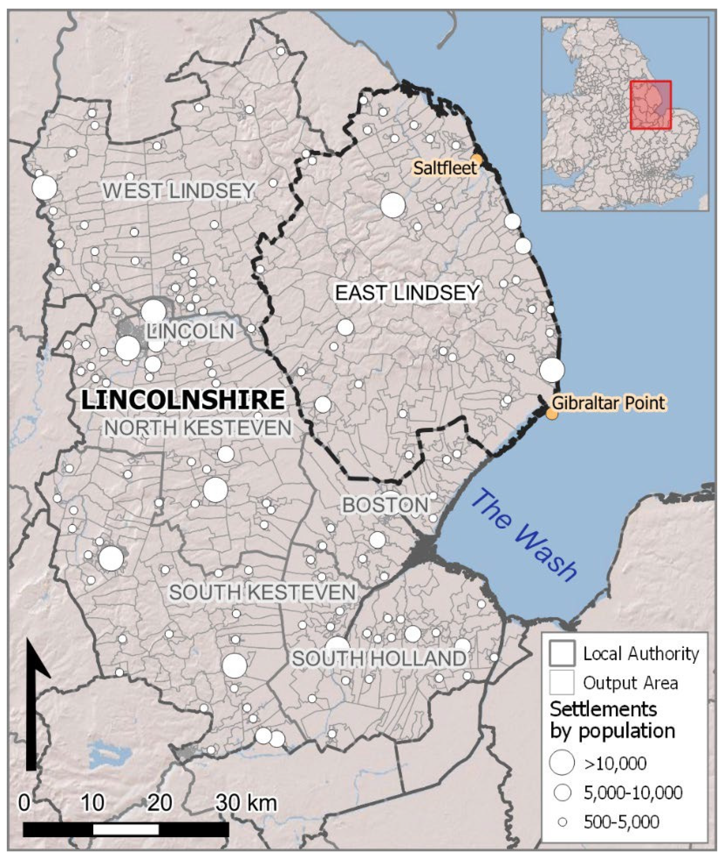
Figure 1. Area map illustrating the Local Authorities of Lincolnshire with East Lindsey, the focus for the ARRCC-L project, containing the greatest area of Lincolnshire’s coastline.
Sustainability 17 08065 g001
Figure 2. OS Six-Inch map of a selected area (Wainfleet) within the region, 1887–1888 (reproduced with permission from National Library of Scotland, https://www.nls.uk).
Sustainability 17 08065 g002
Figure 3. Lidar images (1:20,000 (l) and 1:30,000 (r)) of present waterways and palaeochannels (roddons), within the same region (Wainfleet) (reproduced with permission from M. Macklin). Both illustrate the comparative scale of development across the area compared to that highlighted in the late 19th Century image of Figure 2.
Sustainability 17 08065 g003
Figure 4. Conceptually, the ARRCC-L Framework stands where regional physical and biological (socio-environmental) systems [53] meet current and future community needs [54].
Sustainability 17 08065 g004
Figure 5. The ARRCC-L framework for developing sustainable outcomes under a changing climate in Lincolnshire.
Sustainability 17 08065 g005
Figure 6. A schematic to illustrate the alignment of climate driven data, derived through the corresponding RCP forcing via the UKCP 18 datasets, applied through a scaled change factor to the compound flooding return periods to drive analogous patterns of flooding up to the 100-year horizon.
Sustainability 17 08065 g006
Figure 7. Applying the methodology detailed in Figure 5 and Figure 6, the flood risk between 2020 and (a) 2030; (b) 2050, (c) 2070; and (d) 2100 is distributed across the ARRCC-L study area, demonstrating an increasing severity with time from left to right.
Sustainability 17 08065 g007
Figure 8. Comparison overlay between the ARRCC-L framework’s 2100 Aggregated Flood Profile (AFP) and the Environment Agency’s Flood Zone 2 area map.
Sustainability 17 08065 g008
Figure 9. Mapped illustration of mean flood risk × vulnerability (coastal, fluvial, and pluvial) progressing in Lincolnshire between 2040 (left) and 2100 (right), with 2070 in the middle, driven by climate data provided by UKCP18. Note the considerable increase in compound flood risk inland from the coast, likely brought about by changing patterns in rainfall and the resultant pluvial flooding.
Sustainability 17 08065 g009
Figure 10. Key sites within the Lincolnshire and broader ARRCC-L area (ambulance stations and GP surgeries).
Sustainability 17 08065 g010
Figure 11. Key sites including ambulance stations and GP surgeries are likely to be affected along the coast—increasing likely demand and strain on sites further inland (based on current numbers and placement of these key sites). Health facility data from SHAPE Place (DHSC, 2023) [91].
Sustainability 17 08065 g011
Figure 12. Example of a combined flood risk × multidimensional deprivation composite produced by the ARRCC-L framework, illustrating sub regions of Lincolnshire, UK, that will experience the greatest future vulnerability at the nexus of regional environmental change and multidimensional deprivation.
Sustainability 17 08065 g012
Table 1. An example of properties inundated by the ARRCC-L framework’s simulation for flood events when coupled and driven by climate data from the UKCP18 database. Values shown are absolute numbers and total % of properties inundated by a directly attributable climate-driven, flood event.
RegionRepresentative Concentration Pathway (RCP)
Year/HorizonLincolnshire1.52.64.58.5
2020 (abs) 8716903812,34419,028
2020 (%) 1.81.872.553.94
2030 (abs) 8943965612,71219,456
2030 (%) 1.851.992.634.02
2050 (abs) 901210,11213,15419,935
2050 (%) 1.862.092.724.12
2070 (abs) 914510,34213,38620,038
2070 (%) 1.892.142.774.14
2100 (abs) 957810,55113,99322,115
2100 (%) 1.982.182.894.57
Disclaimer/Publisher’s Note: The statements, opinions and data contained in all publications are solely those of the individual author(s) and contributor(s) and not of MDPI and/or the editor(s). MDPI and/or the editor(s) disclaim responsibility for any injury to people or property resulting from any ideas, methods, instructions or products referred to in the content.