Article

Hydrochemical Formation Mechanisms and Source Apportionment in Multi-Aquifer Systems of Coastal Cities: A Case Study of Qingdao City, China

1
Langfang Integrated Natural Resources Survey Center, China Geological Survey, Langfang 065000, China
2
Innovation Base for Natural Resources Monitoring Technology in the Lower Reaches of Yongding River, Geological Society of China, Langfang 065000, China
3
Qingdao Key Laboratory of Groundwater Resources Protection and Rehabilitation, Qingdao Geo-Engineering Surveying Institute, Qingdao 266101, China
4
Key Laboratory of Geological Safety of Coastal Urban Underground Space, Ministry of Natural Resources, Qingdao 266101, China
*
Authors to whom correspondence should be addressed.
These authors contributed equally to this work.
Sustainability 2025, 17(13), 5988; https://doi.org/10.3390/su17135988
Submission received: 24 April 2025 / Revised: 28 May 2025 / Accepted: 16 June 2025 / Published: 29 June 2025

Abstract

This study systematically unravels the hydrochemical evolution mechanisms and driving forces in multi-aquifer systems of Qingdao, a coastal economic hub. Integrated hydrochemical analysis of porous, fissured, and karst water, combined with PHREEQC modeling and Positive Matrix Factorization (PMF), deciphers water–rock interactions and anthropogenic perturbations. Groundwater exhibits weak alkalinity (pH 7.2–8.4), with porous aquifers showing markedly higher TDS (161.1–8203.5 mg/L) than fissured (147.7–1224.8 mg/L) and karst systems (361.1–4551.5 mg/L). Spatial heterogeneity reveals progressive hydrochemical transitions (HCO3-Ca → SO4-Ca·Mg → Cl-Na) in porous aquifers across the Dagu River Basin. While carbonate (calcite) and silicate weathering govern natural hydrochemistry, evaporite dissolution and seawater intrusion drive severe groundwater salinization in the western Pingdu City and the Dagu River Estuary (localized TDS up to 8203.5 mg/L). PMF source apportionment identifies acid deposition-enhanced dissolution of carbonate/silicate minerals, with nitrate contamination predominantly sourced from agricultural runoff and domestic sewage. Landfill leachate exerts pronounced impacts in Laixi and adjacent regions. This study offering actionable strategies for salinity mitigation and contaminant source regulation, thereby providing a scientific framework for sustainable groundwater management in rapidly urbanizing coastal zones.

1. Introduction

As a critical freshwater resource, groundwater quality and sustainability are directly linked to regional ecological security and socio-economic development. In recent years, accelerated urbanization and industrialization have intensified anthropogenic impacts on groundwater hydrochemistry, particularly in coastal areas where seawater intrusion and complex geological settings synergistically drive significant spatial heterogeneity and complexity in groundwater chemical composition [1]. Existing studies indicate that groundwater chemical evolution is jointly controlled by natural processes (e.g., water–rock interactions, cation exchange, evaporation–concentration) and anthropogenic activities (e.g., agricultural fertilization, sewage discharge, industrial pollution) [2]. However, current research predominantly focuses on single driving factors, with limited systematic analysis of multi-factor interactions, especially regarding the differential responses of multi-aquifer systems (porous, fractured, and karst aquifers) in coastal cities [3].
As a coastal economic hub on China’s Jiaodong Peninsula, Qingdao exemplifies these challenges. Its groundwater system integrates natural geogenic signatures with multi-stress anthropogenic inputs. While the widespread karst landscapes and granite weathering in the Jiaodong Peninsula provide abundant Ca2+, Mg2+, and HCO3, forming a natural HCO3-Ca-type hydrochemical signature [1], intensive agriculture in the Dagu River Basin introduces nitrate pollution (NO3 > 50 mg/L in localized areas) [4], industrial zones along Jiaozhou Bay discharge heavy metals [5], and over-extraction-induced seawater intrusion (marked by elevated Cl and Na+ concentrations) [6]. Despite these documented pressures, prior research has focused narrowly on single aquifer types or pollution sources, failing to address how lithologically distinct aquifers modulate the spatial divergence of multi-factor interactions—a critical gap for managing this interconnected resource [7,8,9,10].
To address these limitations, this study advances a novel comparative framework to unravel aquifer-specific hydrochemical controls in coastal multi-aquifer systems. We hypothesize that (1) porous aquifers exhibit salinization dominated by seawater intrusion and evaporative concentration; (2) fractured aquifers demonstrate heightened vulnerability to anthropogenic pollutants through preferential flow paths; (3) karst aquifers maintain hydrochemical homogeneity via carbonate weathering dominance. Through systematic sampling integrated with PHREEQC inverse modeling and PMF receptor modeling, we quantify the contribution ratios of natural processes (carbonate/silicate weathering) versus anthropogenic sources (agricultural/industrial/sewage inputs), while elucidating aquifer-specific mechanisms controlling contaminant migration and natural attenuation.

2. Materials and Methods
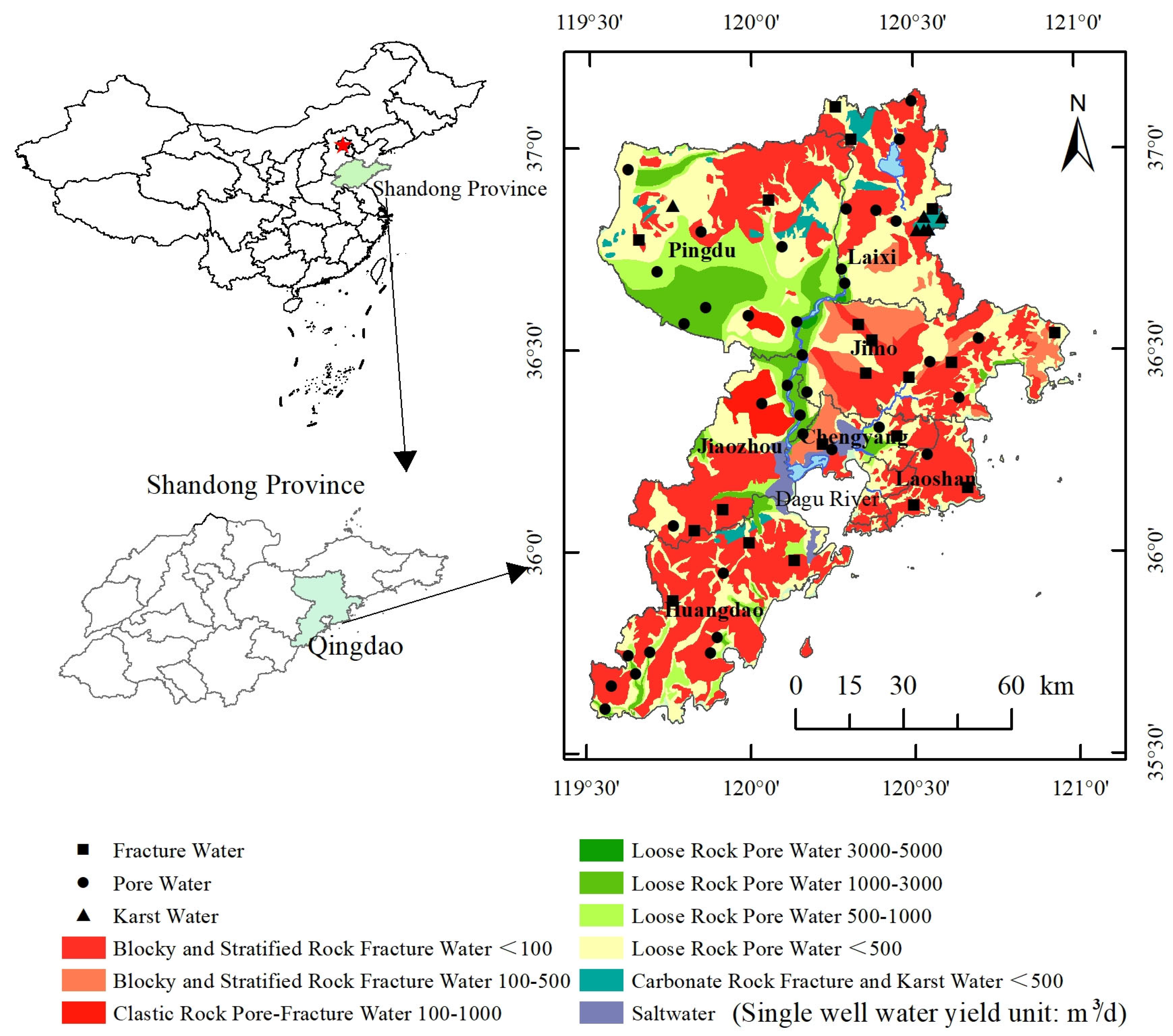
2.1. Study Area

Qingdao City (Figure 1) is situated in the southeastern part of the Shandong Peninsula, China, bordering the Yellow Sea to the east. Characterized by a temperate monsoon climate with maritime influences, the region experiences four distinct seasons, moderate humidity, and an annual precipitation of approximately 662.1 mm. The Dagu River, the longest inland watercourse in Qingdao, spans a vast catchment area along a north–south axis, serving as a critical ecological corridor and primary water resource for the region. Geologically, Qingdao lies at the intersection of the Jiaonan Uplift (northeastern margin) and the Jiaolai Depression (central-southern section) within the Neocathaysian tectonic system, belonging to the Ludong Uplift Belt of the Sino-Korean Paraplatform. NE-trending faults dominate regional magmatic activities and tectonic evolution. Cenozoic tectonic movements have shaped a horst-graben landscape, exhibiting a “U-shaped” topography with elevated eastern and western margins flanking a central depression. Stratigraphically, Paleozoic strata are absent, while Mesozoic Cretaceous volcanic rocks prevail, overlain by Late Yanshanian Laoshan-type granites [11]. The structural stability and permeable lithology provide optimal hydrogeological conditions for groundwater storage and exploitation [12].
The groundwater system in Qingdao demonstrates pronounced spatial heterogeneity (Figure 1). Quaternary porous aquifers are predominantly distributed in the Dagu River Basin, covering Pingdu City, southern Laixi, and western Jimo District. Specific yields exceed 3000 m3/day in southern and northern Pingdu, constituting the primary extraction zones, whereas yields decline below 500 m3/day in central Pingdu, eastern Laixi, and northern Jimo. Fractured groundwater systems are extensively developed in hilly terrains of northeastern Pingdu, northern Laixi, Jimo, Laoshan, and Huangdao Districts, controlled by fault networks. Their productivity varies significantly, with specific yields ranging from 100–500 m3/day in northeastern Pingdu, southwestern Laixi, and southern Huangdao to less than 100 m3/day in parts of Jimo. Karst aquifers are locally confined to carbonate formations in Laixi and Pingdu, exhibiting high yields (exceeding 500 m3/day) but challenging exploitation conditions. Notably, groundwater discharge zones in southwestern Pingdu (characterized by a cone of depression) and the Dagu River estuary suffer severe salinization due to seawater intrusion.

2.2. Sample Collection and Testing Analysis

This study systematically established 62 monitoring points (36 porous water, 20 fractured water, and 6 karst water) across Qingdao’s plain area, considering aquifer type distribution, township demographics, and geomorphic zoning (Figure 1). In situ measurements of temperature, pH, and total dissolved solids (TDSs) were performed using a multiparameter water quality probe (SMARTROLL; accuracy: pH ± 0.01, TDS ± 1%). Filtered samples (0.45 μm Whatman GF/C membrane) were acidified to pH < 2 with ultrapure nitric acid, stored in pre-cleaned polyethylene bottles (electrical conductivity < 2 μS/cm), and transported at 4 °C to Qingdao Geological Survey Laboratory. Analyses followed China’s Groundwater Quality Standard (GB/T 14848-2017) [13]: Ca2+, Mg2+, Na+, and K+ were determined by flame atomic absorption spectroscopy (contrAA300, Jena; detection limit 0.01 mg/L); HCO3 was measured via hydrochloric acid titration (±0.1 mmol/L accuracy); Cl, NO3, and SO42− were analyzed by ion chromatography (IC883, Metrohm; Metrosep A Supp 5 column, eluent 2.0 mM Na2CO3/0.75 mM NaHCO3, flow rate 0.7 mL/min). Charge balance errors (CBEs) were maintained within ±5%, with outliers reanalyzed.

2.3. Research Methods

Hydrochemical datasets were statistically analyzed (mean, standard deviation, coefficient of variation) and classified using Durov diagrams. Ionic ratios (e.g., Ca2+ + Mg2+ vs. HCO3 + SO42−) and Gibbs plots qualitatively identified dominant processes (evaporation, rock weathering, cation exchange). Hydrogeochemical evolution mechanisms were deciphered by integrating Cl/NO3 background values, groundwater level monitoring (pressure transducers, ±0.1 m accuracy). Spatial distribution maps of hydrochemical parameters were generated using interpolation analysis in ArcGIS 10.8. Mineral saturation indices (SI) were computed using PHREEQC 3.7 (USGS geochemical modeling software, phreeqc.dat database, temperature set to mean ± 2 °C). Positive Matrix Factorization (EPA PMF 5.0) was implemented with input parameters including eight ion concentrations (Ca2+, Mg2+, Na+, K+, HCO3, SO42−, Cl, NO3) and uncertainties (instrumental error +10% detection limit). Factor numbers were optimized via Q-minimization and residual analysis. Ion ratio diagrams and model outputs were visualized in Origin 2023, with statistical significance at p < 0.05.

3. Results and Discussion

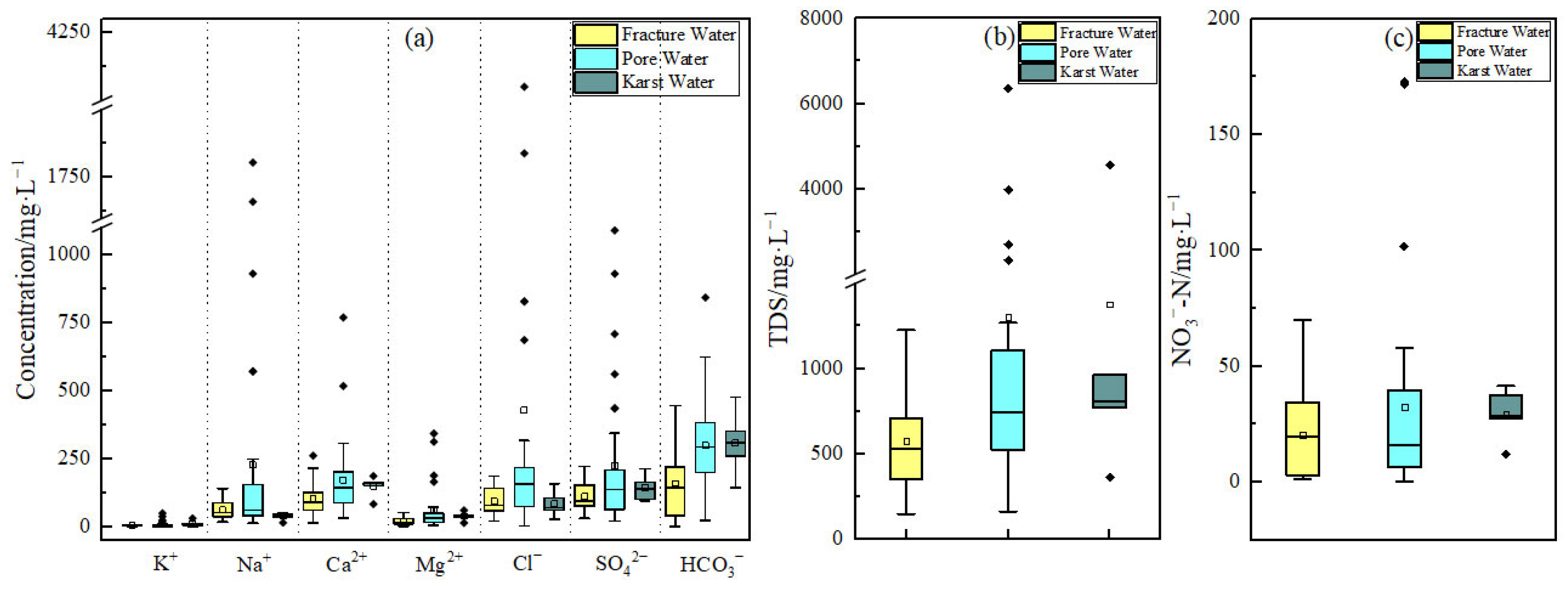
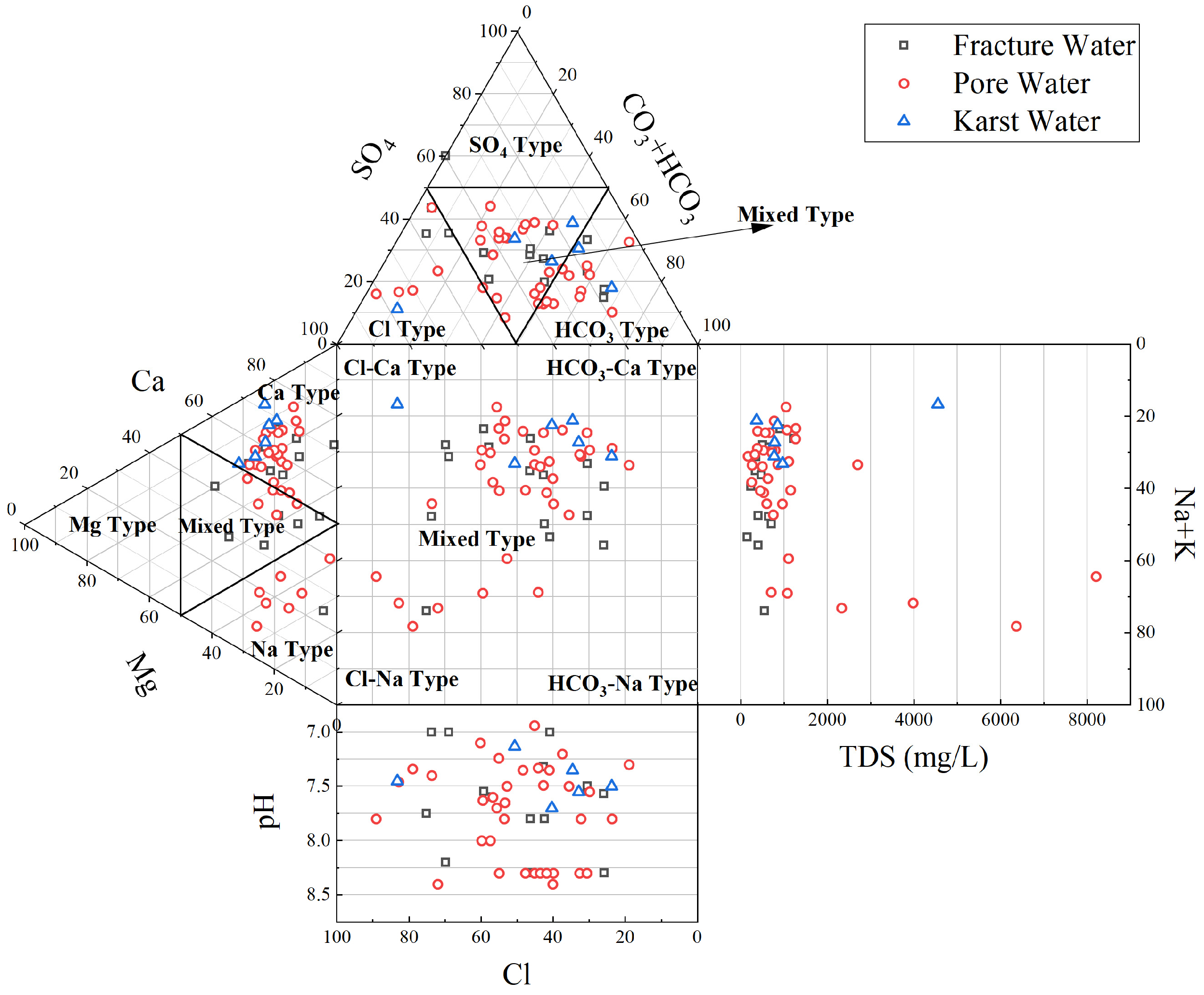
3.1. Hydrochemical Characteristics of Groundwater

3.1.1. Characteristics of the Hydrochemical Composition of Groundwater

Statistical results of key hydrochemical parameters for porous, fractured, and karst groundwater are summarized in Table 1. The pH of groundwater ranges from 6.9 to 7.4, indicating weakly alkaline conditions (mean 7.5–7.7). Porous water exhibits a mean total dissolved solids (TDS) of 716.6 mg/L, with 61.11% of samples classified as freshwater (TDS < 1000 mg/L). Notably, three sites (P32, P33, P34) near Pingdu City and the Dagu River estuary show significantly elevated TDS (>3977 mg/L, saline water), while others are brackish. Fractured and karst groundwater have lower TDS values (mean 562.2 mg/L and 743.5 mg/L, respectively), with 95% and 83.33% of samples classified as freshwater. All parameters except pH display coefficients of variation (CV) >0.2, with porous water showing higher spatial heterogeneity (e.g., Cl CV = 2.08 vs. 0.56 for fractured water). Nitrate distribution further highlights anthropogenic impacts: porous water has a mean NO3-N concentration of 23.2 mg/L (maximum 101.7 mg/L), with 10% of samples classified as nitrate-type water, compared to 20.4 mg/L and 44.7 mg/L for fractured and karst water, respectively.
From the boxplot (Figure 2) and Durov diagram (Figure 3), it can be observed that cations in the groundwater are dominated by calcium ions, followed by sodium and magnesium ions. The anions are primarily bicarbonate, followed by sulfate and chloride ions. Most of the pore water samples show a gradual transition from the HCO3-Ca type to SO4-Ca type, with a small portion exhibiting a transition toward the Cl-Na type. This indicates that the hydrochemical type of the pore water is influenced by mineral dissolution and evaporation–concentration processes, resulting in a diverse range of hydrochemical types, with relatively high TDS and significant dispersion. Fractured water is predominantly of the HCO3-Ca type and HCO3·SO4-Ca·Na type, with some samples leaning towards the SO4-Ca type, showing diverse hydrochemical characteristics. In karst water, the dominant anion is bicarbonate, and the cation is primarily calcium, with hydrochemical types being HCO3-Ca and HCO3·SO4-Ca, whose chemical composition is controlled by the dissolution of carbonate rocks, leading to a more concentrated TDS distribution.
As shown in Figure 2c, the distribution of nitrate nitrogen in pore water, fractured water, and karst water differs significantly. The median of nitrate nitrogen in pore water is relatively low; however, it exhibits a high frequency of outliers and a broad distribution range, and 10% of the pore water monitoring points are classified as nitrate-type water, reflecting a significant influence from human activities such as agricultural fertilizer application and domestic wastewater. In contrast, fractured water, while subject to a lower pollution load than pore water, has a higher median nitrate nitrogen concentration, with a more concentrated distribution. Notably, 5% of fractured water monitoring points are classified as nitrate-type water, indicating that fractured aquifers are more vulnerable. The nitrate nitrogen concentration in karst water is the lowest and most stable, reflecting a strong self-purification ability of the karst water system with minimal interference from human activities. Pore water is widely distributed with active replenishment, and its quality is significantly affected by human activities. Fractured water, due to preferential flow paths and bedrock fractures, is more susceptible to surface pollution sources [14]. Karst water, with its rapid circulation and dilution processes, experiences the least pollution [15].

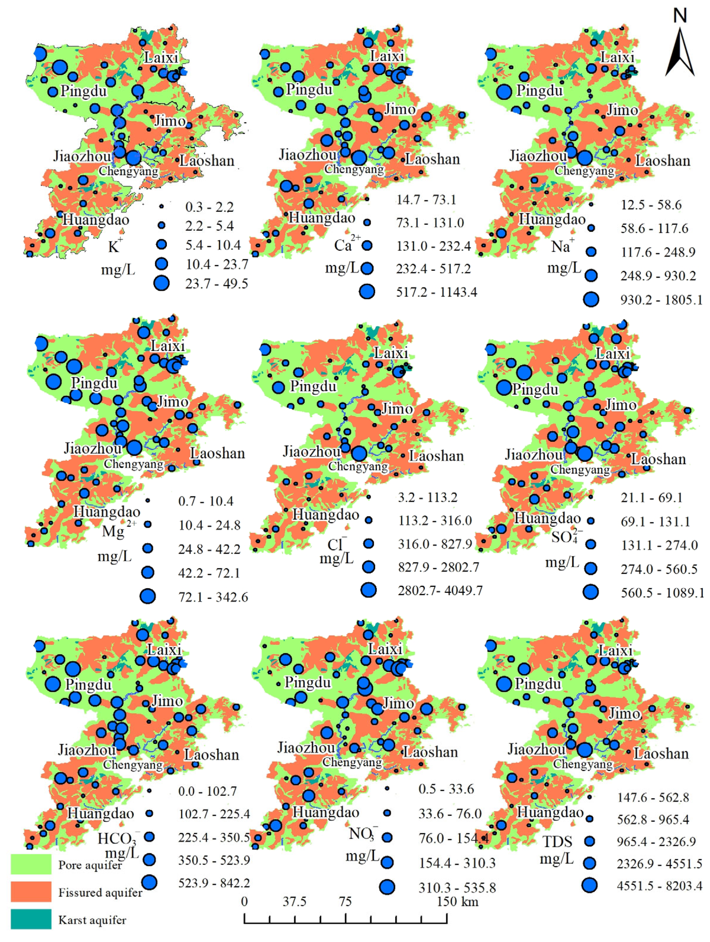
3.1.2. Distribution Characteristics of Groundwater Hydrochemistry

The spatial distribution of groundwater hydrochemical characteristics in Qingdao is illustrated in Figure 4. In the carbonate-rich areas of eastern Pingdu and Laixi, prolonged water–rock interactions result in elevated HCO3 (mean > 250 mg/L) and Ca2+ (peak 769.2 mg/L), forming the dominant HCO3-Ca-type water. However, low-lying zones in Pingdu are identified as pollutant sinks due to agricultural fertilization (local NO3-N >100 mg/L) and industrial discharges (SO42− mean 122.4 mg/L) [16]. In Laixi, domestic sewage inputs (Cl anomaly 186.1 mg/L) drive hydrochemical evolution toward SO4-Ca and NO3-Ca mixed types [17]. Fractured aquifers in Laoshan and Huangdao, characterized by high-altitude recharge (residence time <5 years) and rapid flow (TDS mean 562.2 mg/L, CV = 0.49), maintain HCO3-Ca-type water with high ion migration rates [18]. Human activities in Jimo significantly alter fractured water chemistry, with some samples shifting to HCO3·SO4-Ca·Na types, highlighting low contaminant retention in fissured media.
The Dagu River estuary and western Pingdu exhibit Cl-Na-type water due to seawater intrusion (Cl > 4000 mg/L, Na+ > 65%) and groundwater over-extraction-induced depression cones. Spatial correlation analysis reveals that Cl and Na+ hotspots align with high conductivity zones (TDS > 3000 mg/L), demonstrating synergistic effects of saline intrusion and hydraulic gradients. Overall, the hydrochemical differentiation in Qingdao is governed by a ternary coupling mechanism of “lithology-anthropogenic activities-hydrodynamics”. The spatial segregation of salinization (Cl-Na-type) and pollution (NO3-Ca-type) hotspots provides critical targets for coastal groundwater management.

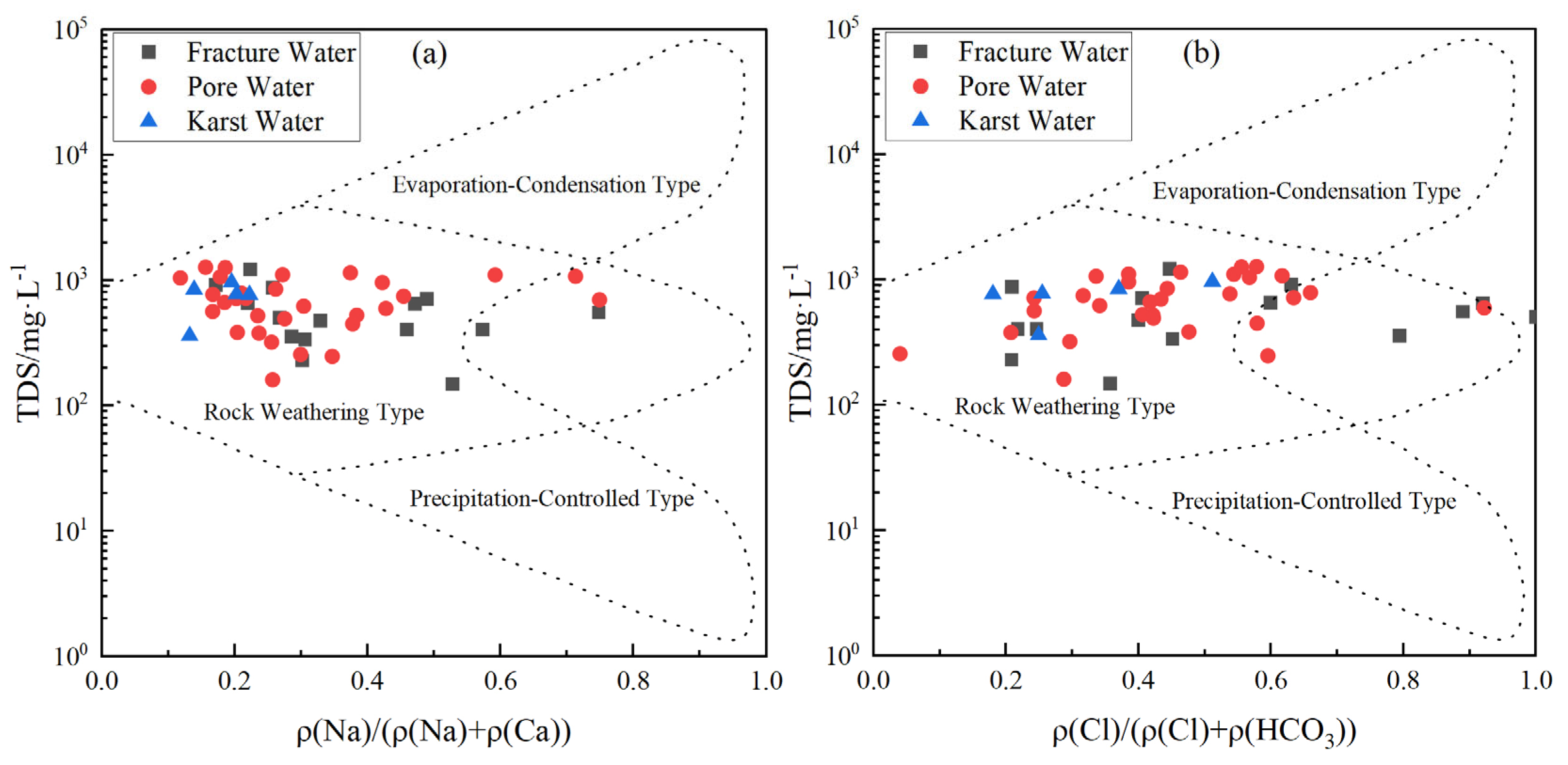
3.2. Analysis of Natural Sources of Hydrochemical Components in Different Groundwater Types

3.2.1. Water–Rock Model Analysis

Hydrochemical analysis based on Gibbs diagrams (Figure 5) reveals differential controls of rock weathering and evaporation–concentration on groundwater chemistry. Over 70% of Quaternary porous water samples cluster in the rock weathering domain, supported by high Ca2+/Na+ (molar ratio mean 3.2) and HCO3/Na+ (mean 4.8), indicating synergistic contributions from silicate and carbonate dissolution. Porous water in localized discharge zones (e.g., southwestern Pingdu) shifts toward the evaporation–concentration endmember due to prolonged residence time (>10 years) and enhanced evaporation (Cl > 2000 mg/L), with TDS peaking at 8203.5 mg/L. Despite anthropogenic inputs (NO3 mean 23.2 mg/L, SO42− mean 122.4 mg/L), the low hydraulic conductivity in porous media significantly restricts contaminant migration, resulting in localized pollutant accumulation [19,20].
Bedrock fissure water exhibits minimal evaporation–concentration signals (Cl/Na+ ≈ 1.1) but significant anthropogenic impacts: 30% of samples exceed the NO3 drinking water standard (30 mg/L), and preferential flow paths (fracture aperture > 0.5 mm) facilitate vertical contaminant migration (SO42− peak 221.7 mg/L in Huangdao industrial zones). Karst water, dominated by carbonate dissolution (Ca2++Mg2+ > 85%), shows high homogeneity (HCO3 CV = 0.35) with negligible evaporite contributions (Na+/Cl < 0.5).
Thus, rock weathering is the primary process controlling the chemical composition of most water bodies. Evaporative–concentration effects mainly influence pore water, particularly in groundwater discharge areas, where evaporation intensifies and leads to the accumulation of dissolved ions. Due to the open flow paths of fractured water, the impact of human activities is more pronounced, with significant inputs from pollution sources. Although pore water is also affected by pollution, its relatively slow movement and isolation make it less susceptible to these influences.
Hydrogeochemical modeling (Figure 6) further delineates the following: most samples align with carbonate-silicate mixed weathering trends (n(Ca2+)/n(Na+) = 2.5–5.0), while only 12% of porous and 8% of fractured water reflect evaporite dissolution (n(Mg2+)/n(Na+) < 0.3). The stronger silicate weathering signature in karst water (n(HCO3)/n(Na+) = 8.2 vs. 4.5 in porous water) underscores continuous feldspar dissolution during deep circulation [21,22,23].

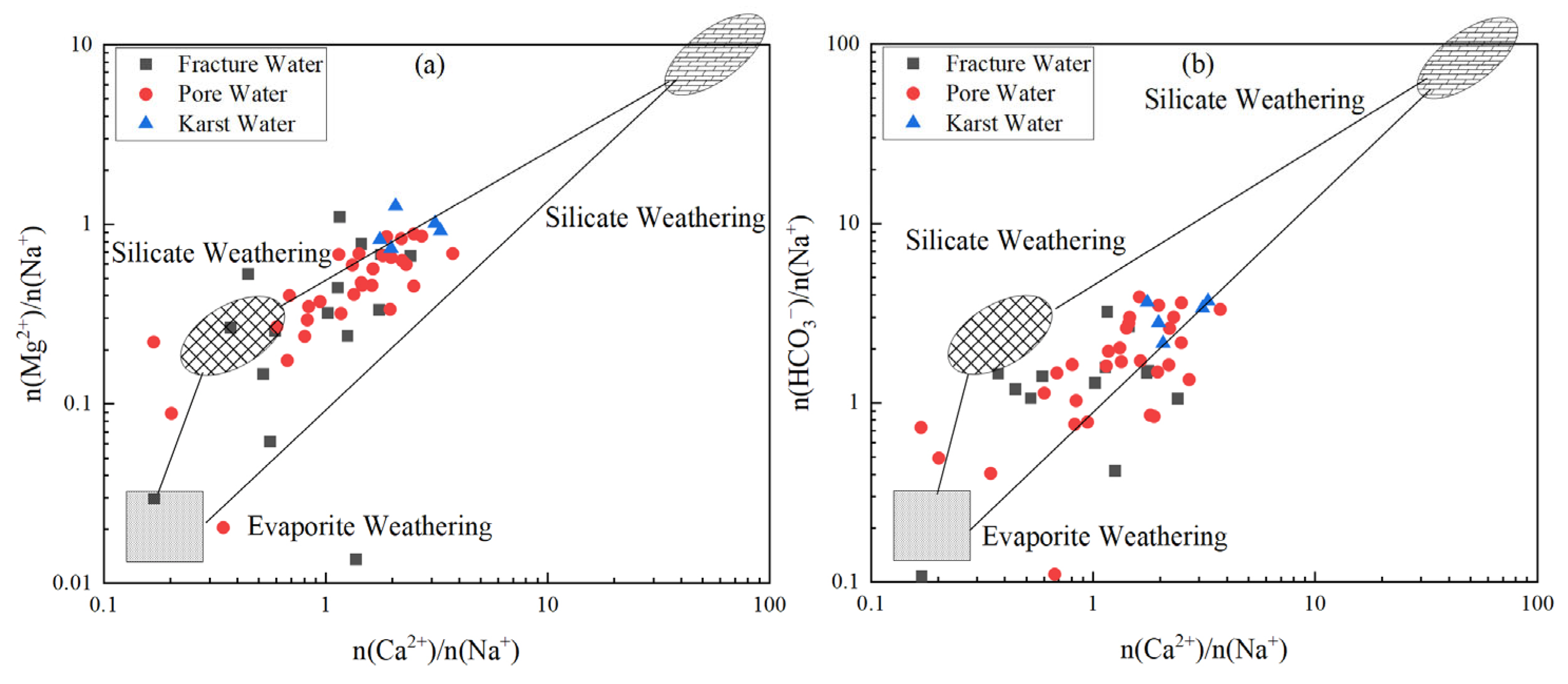
3.2.2. Major Weathering Processes and Hydrochemical Evolution

Ionic ratio analysis (Figure 7a) indicates that 88% of groundwater samples align with the halite dissolution line (γ(Na+ + K+)/γ(Cl) = 1), with 26.67% of porous water, 66.67% of fractured water, and 20% of karst water plotting below the line (Cl excess, γ < 1). This suggests significant influences from cation exchange (e.g., Na+-Ca2+ replacement) and anthropogenic inputs (e.g., Cl from sewage) alongside silicate weathering (γ > 1 in 12% of samples) [24]. Cl excess in porous water (e.g., Dagu River estuary, Cl > 4000 mg/L) correlates spatially with seawater intrusion and agricultural drainage, whereas fractured water (Cl/Na+ ≈ 1.1) reflects preferential flow enhancing vertical salt transport.
The γ(Ca2+ + Mg2+)/γ(HCO3 + SO42−) relationship (Figure 7b) reveals that 66% of samples follow the 1:1 line, dominated by carbonate (calcite, dolomite) and evaporite (gypsum) dissolution [25,26,27]. Specifically, 87% of karst and 74% of porous water plot above the carbonate dissolution line (Ca2+ + Mg2+ excess), while 33.3% of fractured water deviates due to SO42− anomalies (industrial zone peak 221.7 mg/L), indicating sulfate-driven mineral dissolution (e.g., pyrite oxidation).
The γ(Ca2+)/γ(Mg2+) ratios (Figure 7c) further delineate differential contributions from calcite and dolomite: 78% of porous and 65% of karst water cluster near 0.5 (co-dissolution), whereas fractured water ratios center at 0.8–1.2 (mean 1.05), highlighting dolomite weathering dominance [28,29,30]. Additionally, pyroxene dissolution in basaltic fractures (Mg2+/Ca2+ = 0.3–0.5) elevates Mg2+ concentrations in fractured water.

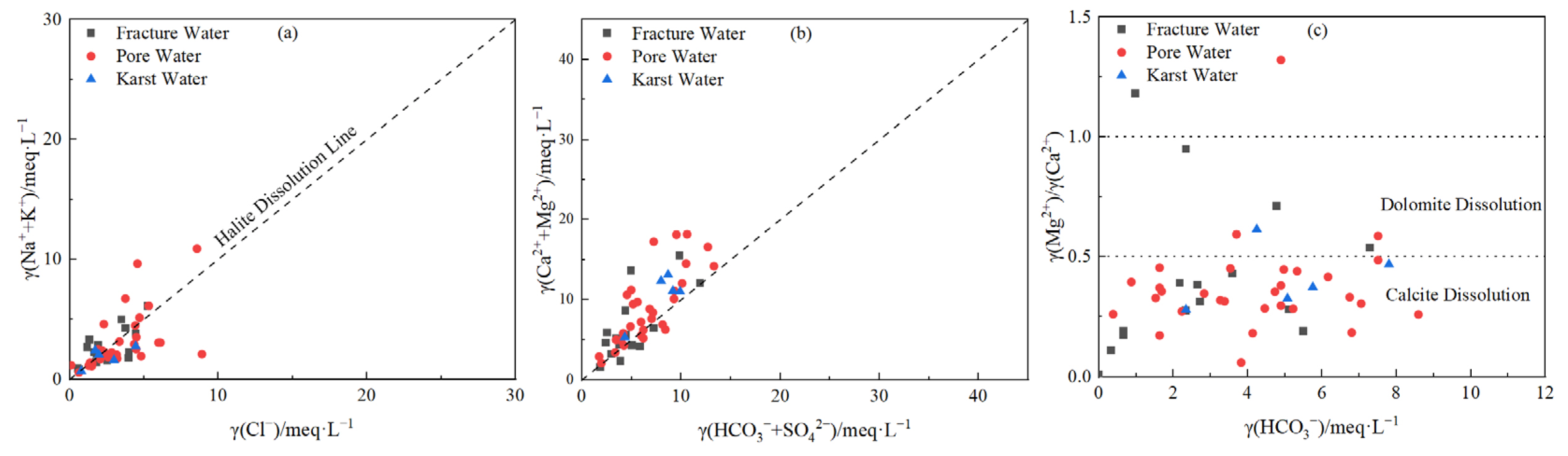
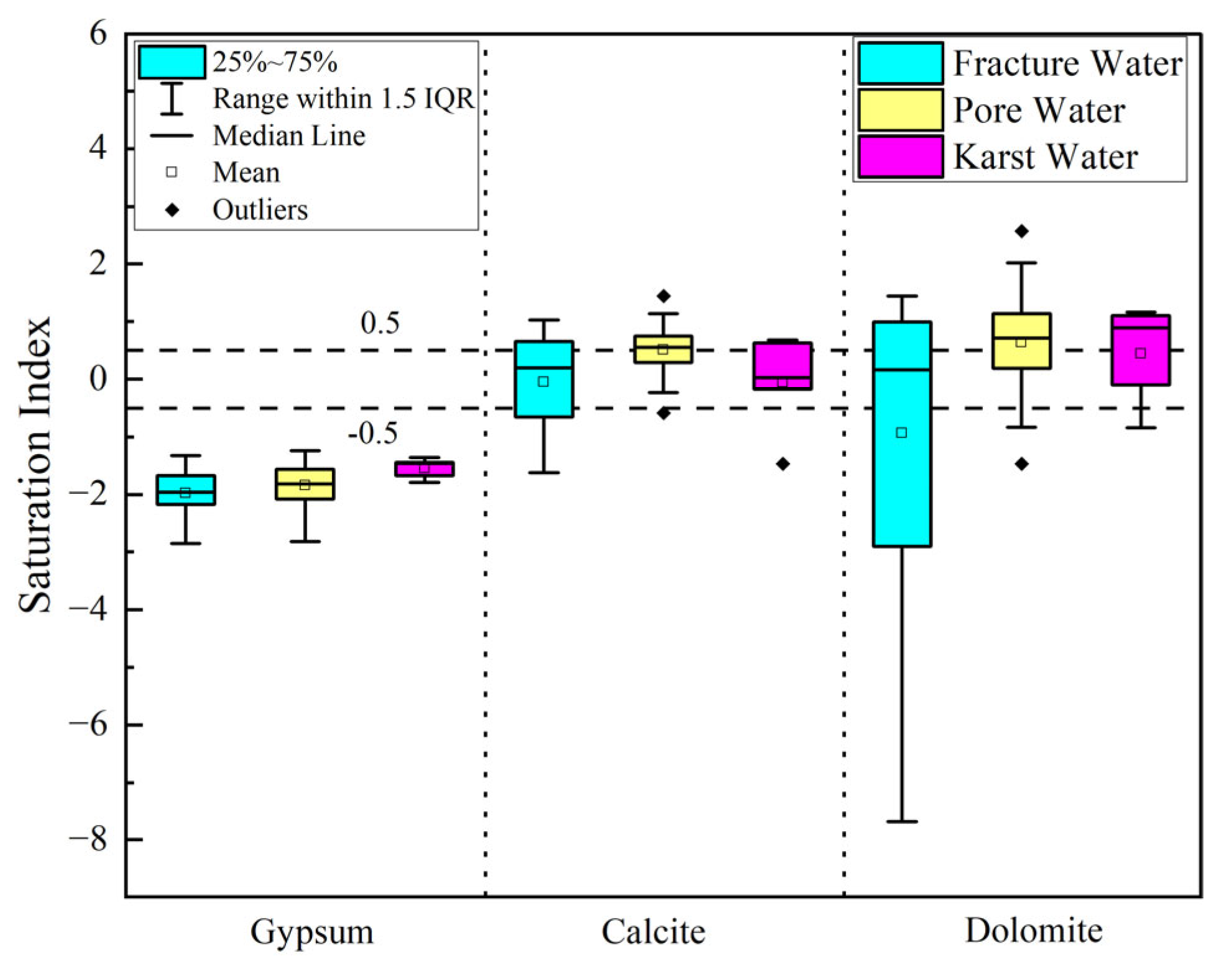
3.2.3. Mineral Dissolution Equilibrium

The mineral saturation index (SI) is a commonly used indicator in hydrogeochemical studies, providing a direct insight into whether specific minerals are in a dissolved or precipitated state in the water. It also reveals the conditions for the formation of hydrochemical components [31,32,33,34]. The SI of relevant minerals in different water bodies of the study area was simulated using the PHREEQC Interactive module, and boxplots of the mineral saturation indices for common minerals (gypsum, calcite, dolomite) in various groundwater types are shown in Figure 8. The boxplot statistically synthesizes SI distributions derived from hydrogeochemical datasets, with the interquartile range (IQR: 25th–75th percentiles) delineating the central 50% of mineral saturation states. The median line represents equilibrium tendencies, while whiskers (1.5 × IQR) define natural variability thresholds; outliers beyond this range signify extreme SI anomalies attributable to localized geochemical perturbations. This analysis presents the chemical states and distribution characteristics of key minerals in fractured water, pore water, and karst water from multiple perspectives. By analyzing the central tendency and dispersion of the SI values, it is possible to not only reveal the dissolution and precipitation behavior of various minerals but also reflect the complexity and variability of the water chemical environment.
The SI values for gypsum exhibit relatively low dispersion across the three types of groundwater. The SI values of fractured water and pore water are concentrated between −3 and −1, indicating that gypsum is in a stable undersaturated state in these water bodies, showing consistent dissolution behavior. The SI values for karst water are more tightly clustered and close to −0.5, suggesting that in karst environments, local influences from external sources (such as evaporative concentration or dissolution of underground rocks) cause some fluctuations in the SI value as it approaches equilibrium. The low dispersion of gypsum reflects its insensitivity to changes in the water chemical conditions.
The SI distribution for calcite is markedly different from gypsum, exhibiting greater dispersion. The SI distribution of fractured water is the broadest, ranging from −1.5 to 1, spanning the boundaries of dissolution, equilibrium, and oversaturation. Karst water also shows some dispersion, which may be related to the CO2 degassing and calcium ion concentration effects caused by the rapid flow in fractured and karst waters, as well as the impact of related human activities. In contrast, the SI values for pore water and karst water are more concentrated, primarily ranging from 0 to 1, reflecting the stability of calcite’s dissolution-precipitation trend in the pore water environment. Overall, the higher dispersion of calcite in fractured and karst waters is influenced by local hydrodynamics and karst processes, while the lower dispersion in pore water indicates more uniform water chemistry conditions.
Dolomite’s SI values show the highest dispersion in fractured water, with a quartile range from 0.5 to −4, and several outliers. This suggests that in fractured water environments, the chemical behavior of dolomite is controlled by complex hydrodynamic and reactive conditions, such as local fluid replenishment or differences in flow paths leading to fluctuations in its saturation state. In pore water and karst water, the SI values are relatively concentrated, primarily ranging from −0.5 to 1, with a narrow fluctuation range, indicating that dolomite tends toward an equilibrium state in these waters, with more stable chemical conditions. In general, the instability of dolomite’s SI value in fractured water is closely related to the pronounced alternation of water in fractured zones.
The dispersion of the mineral saturation index not only reflects the dissolution and precipitation trends of various minerals in different water bodies but also reveals differences in the stability of hydrodynamic conditions and chemical environments. The generally higher dispersion in fractured water (especially for calcite and dolomite) indicates complex hydrodynamic conditions influenced significantly by local geological structures and water alternation processes. In contrast, pore water and karst water show lower dispersion, reflecting the more uniform hydrochemical characteristics and more stable water chemical formation conditions of these two types of water.

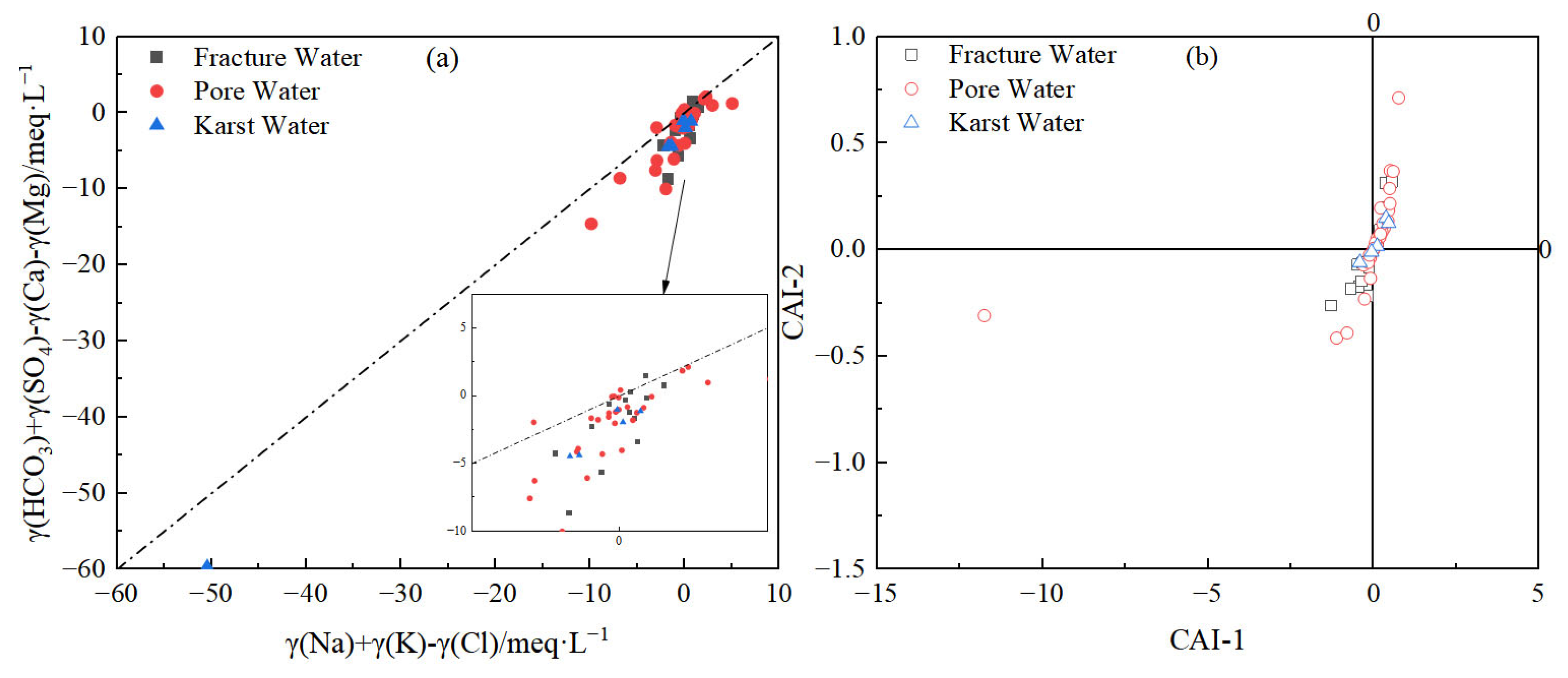
3.2.4. Cation Exchange Processes

The analysis of γ(HCO3) + γ(SO42−) − γ(Ca2+) − γ(Mg2+) versus γ(Na+) + γ(K+) − γ(Cl) (Figure 9a) and the chloro-alkaline index (CAI) (Figure 9b) confirms distinct cation exchange behaviors across groundwater types. The formula for calculating the chlor-alkali index is shown in Equations (1) and (2) below. Approximately 4/5 of porous water and all karst water samples exhibited Na+/K+ depletion and Ca2+/Mg2+ enrichment, while nearly 2/3 of fractured groundwater samples displayed the opposite trend (Figure 9a). This divergence indicates contrasting cation exchange directions: Na+-Ca2+ exchange dominates in porous and karst systems, whereas Ca2+-Na+ exchange prevails in fractured groundwater [35,36].
CAI-1 = γ(Cl − Na+ − K+)/γ(Cl)
CAI-2 = γ(Cl − Na+ − K+)/γ(HCO3 + SO42− + CO32− + NO3)
In Figure 9a, most groundwater samples cluster near the 1:1 line, reflecting strong symmetry between cation concentrations and confirming the significant role of cation exchange (e.g., Na+-Ca2+) in hydrochemical evolution [7,9,10,37]. Fractured and porous groundwater data show tighter clustering, suggesting consistent exchange mechanisms within each aquifer type. In contrast, karst water samples deviate slightly, particularly at lower values, likely due to unique exchange processes in carbonate-rich environments, such as enhanced Ca2+ replacement under high-calcium conditions (Figure 9a).
The CAI results further validate these trends (Figure 9b). CAI > 0 (observed in ~2/3 of porous water and all karst water samples) indicates Na+/K+ release from groundwater to the aquifer matrix, while CAI < 0 (predominant in fractured groundwater) suggests reverse exchange. Notably, the shift in cation exchange direction in porous water correlates with groundwater overexploitation-induced cone-of-depression and secondary seawater intrusion in the Dagu River estuary. These anthropogenic activities amplify groundwater salinization and soil sodicity, exacerbating Ca2+/Mg2+ leaching and pore clogging, which further aggravates soil compaction [38]. This data-driven interpretation aligns with the observed hydrochemical anomalies and underscores the interplay between natural processes and human impacts in shaping groundwater quality.

3.3. Analysis of Anthropogenic Sources of Hydrochemical Components in Different Groundwater Types

The presence of nitrate-dominated water samples highlights significant anthropogenic influences on groundwater chemistry in the study area (Figure 10). To further elucidate these impacts, nitrate (NO3), chloride (Cl), and sulfate (SO42−)—sensitive indicators of human activities—were analyzed. Acid deposition (e.g., sulfuric and nitric acids) from agriculture, industry, and urbanization has notably enhanced carbonate weathering. As shown in Figure 10a, the ratios γ(Ca2+)+γ(Mg2+)/γ(HCO3) and γ(SO42−)/γ(HCO3) reveal the involvement of both carbonic and sulfuric acids in carbonate dissolution. Pure carbonic acid-driven dissolution would yield γ(Ca2+)+γ(Mg2+)/γ(HCO3) = 1 and γ(SO42−)/γ(HCO3) = 0, while sulfuric acid-dominated dissolution would result in γ(SO42−)/γ(HCO3) = 1 and γ(Ca2+)+γ(Mg2+)/γ(HCO3) = 2 [25,26,39]. Data confirm that both acids contribute to carbonate dissolution in select fractured and porous groundwater samples, underscoring the role of anthropogenic acid inputs in altering natural weathering processes.
Cl, a stable component in natural water systems, serves as a reliable tracer for sewage/fecal contamination or dilution effects, as its concentration changes only through mixing with other Cl-enriched sources [40,41,42,43]. Similarly, SO42− and NO3 act as markers for industrial discharges and agricultural/livestock activities, respectively [44,45,46]. Figure 10a demonstrates that NO3/Ca2+ and SO42−/Ca2+ ratios in most groundwater samples align with agricultural and domestic wastewater influences, except for a few outliers linked to industrial pollution. Furthermore, the NO3/Cl versus-Cl molar relationship (Figure 10b) reveals that low NO3/Cl ratios coupled with high Cl concentrations dominate the dataset, indicating mixed contamination from sewage and fecal sources [47,48,49,50,51,52]. Only 5.35% of samples exhibit nitrate levels associated with natural soil nitrogen, while the majority cluster between agricultural and domestic wastewater endmembers, with porous and fractured groundwater samples leaning toward sewage/fecal inputs (Figure 10c).
These findings underscore the dual impact of agricultural and domestic wastewater on groundwater quality. Nitrate accumulation, particularly in porous and fractured aquifers, not only degrades water quality but also poses long-term health risks, including elevated cancer incidence [53,54,55]. This data-driven analysis confirms that human activities—notably unsustainable agricultural practices and inadequate wastewater management—are the primary drivers of groundwater contamination in the study area, aligning with the “natural-anthropogenic” coupling model proposed in the conclusions.

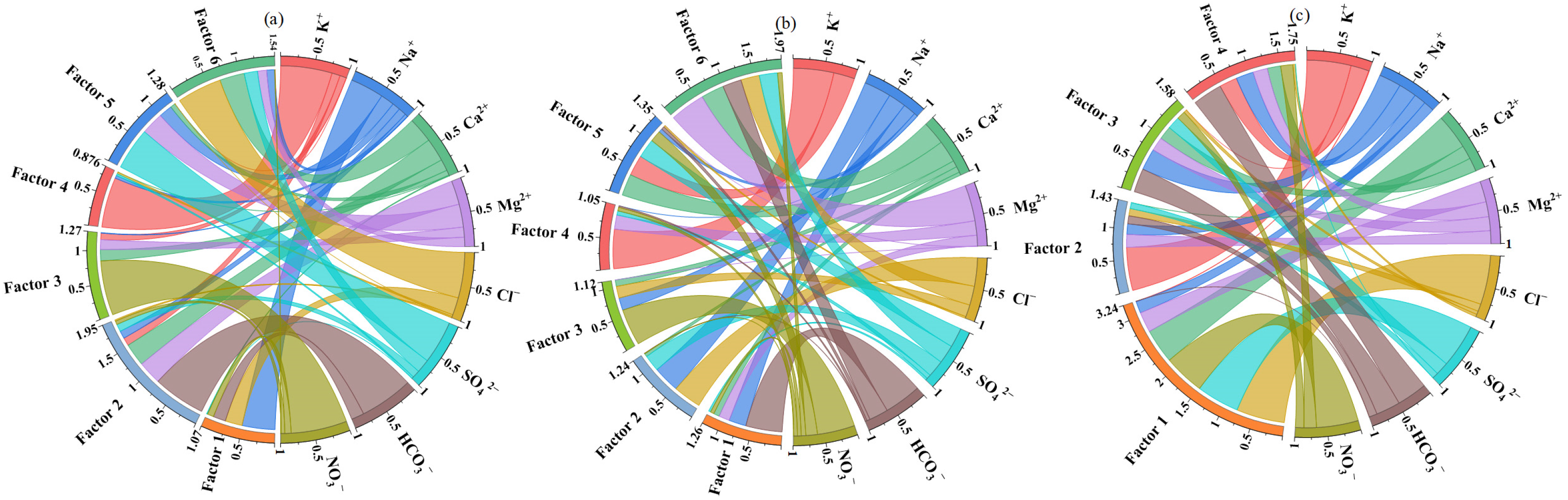
3.4. Source Apportionment of Hydrochemical Components Through PMF Analysis

Positive Matrix Factorization (PMF) was employed to identify pollution sources in pore water, fissure water, and karst water (Figure 11). Concentration data and uncertainty values for all eight hydrochemical components were incorporated, with signal-to-noise ratios (S/N) classifying all species as “strong” (S/N > 2), ensuring high data quality. The model was iterated 20 times with factor numbers optimized between 4 and 6, guided by Q-minimization and residual analysis. Scaled residuals for all elements fell within [−3, 3] and followed a normal distribution, confirming stable solutions. High explanatory power was demonstrated by R2 > 0.9 for all factors, aligning with PMF best practices.
For pore water, Factor 1 (dominated by NO3 and Cl) reflects agricultural nitrogen fertilizer application and domestic sewage inputs; Factor 2 (characterized by HCO3, Ca2+, Mg2+) represents natural carbonate weathering; Factor 3 (K+) indicates agricultural potassium fertilizer use; Factors 4–5 (SO42−, HCO3, Ca2+, Mg2+) suggest gypsum dissolution processes; Factor 6 (co-variation of Cl and Na+) demonstrates seawater intrusion and evaporative concentration effects.
In fissure water, Factor 1 (HCO3) predominantly reflects carbonate weathering; Factor 2 (Cl, Na+, SO42−) corresponds to industrial contamination; Factor 3 (association of SO42− with Cl/Na+) indicates domestic wastewater discharge; Factor 4 (K+, Mg2+, SO42−) suggests feldspar weathering; Factor 5 (NO3 involvement) confirms bedrock dissolution; Factor 6 (Na+ and K+ dominance) represents cation exchange processes. Karst water analysis revealed the following: Factor 1 (Cl, SO42−, NO3) aligns with leachate contamination from the Laixi Municipal Landfill; Factor 2 (K+ as an independent contributor) characterizes a unique Ca2+/Mg2+ ↔ Na+/K+ substitution mechanism; Factor 3 (HCO3 with multi-ion correlations) reflects combined carbonate dissolution and cation exchange processes; Factor 4 (HCO3 dominance) indicates nitrate-involved mineral weathering pathways.
These findings show strong consistency with regional pollution source distributions and hydrogeochemical characteristics. For instance, seawater intrusion in pore water (Factor 6) is validated by elevated Cl/Na+ ratios and historical salinity data, while industrial contamination in fissure water (Factor 2) corresponds to nearby factory distributions. The pollution signature of karst water Factor 1 matches the geographical location of the Laixi landfill. The PMF analysis not only quantifies contributions from natural processes (e.g., carbonate weathering, gypsum dissolution) but also clarifies the relative weights of anthropogenic impacts (agricultural activities, domestic sewage, and industrial emissions), providing critical data support for establishing a “natural-anthropogenic” coupled model. This study confirms that groundwater chemical evolution results from synergistic multi-factor interactions, with human activities significantly altering the pathways and intensity of natural water–rock interactions.

3.5. Multi-Source Interaction Mechanisms in Regional Hydrochemical Formation

The hydrochemical composition of groundwater in Qingdao’s multi-aquifer systems arises from the interplay of natural geogenic processes and anthropogenic perturbations, with distinct mechanisms governing porous, fractured, and karst aquifers. Natural processes, including carbonate weathering, silicate dissolution, and seawater intrusion, establish the baseline hydrochemical framework. Carbonate weathering dominates karst aquifers, generating HCO3-Ca type water with low spatial variability, while silicate weathering and evaporative enrichment contribute to elevated Na+ and Cl in porous aquifers, particularly in coastal discharge zones. Seawater intrusion, driven by over-extraction and hydraulic gradient reversal, further exacerbates salinization in porous aquifers, as evidenced by Cl/Na+ ratios > 1.1 and spatial correlation with depression cones. In contrast, fractured aquifers exhibit rapid flow dynamics due to preferential pathways, amplifying anthropogenic impacts such as nitrate infiltration from agricultural runoff and sulfate enrichment from industrial discharges.
Anthropogenic activities alter hydrochemical evolution through dual pathways: direct inputs (e.g., nitrate from fertilizers, chloride from sewage) and indirect modifications to hydrodynamic conditions. PMF source apportionment highlights agricultural activities as the primary contributor to nitrate in porous aquifers, while industrial effluents dominate sulfate anomalies in fractured systems. The synergistic effects of acid deposition (H2SO4, HNO3) enhance carbonate dissolution in karst aquifers, shifting ionic ratios beyond natural weathering thresholds. PHREEQC simulations further differentiate aquifer-specific responses: porous media retain contaminants due to low hydraulic conductivity, whereas fractured systems facilitate vertical pollutant migration, and karst aquifers buffer anthropogenic inputs through rapid dilution and carbonate equilibration.
This integrated analysis underscores how lithological heterogeneity and hydrodynamic conditions modulate multi-source interactions. Porous aquifers act as sinks for salinity and slow-evolving contaminants, fractured aquifers reflect acute vulnerability to point-source pollution, and karst systems demonstrate resilience tied to carbonate buffering. These findings provide a mechanistic basis for tailored management strategies, emphasizing salinity mitigation in porous aquifers, pollution interception in fractured zones, and enhanced monitoring of karst systems to address emerging anthropogenic pressures.

4. Conclusions

(1)
Groundwater in Qingdao is weakly alkaline (pH 7.2–8.4), with Ca2+ and Mg2+ as dominant cations and HCO3 as the primary anion. Its chemical composition is co-controlled by natural geogenic processes (carbonate/silicate weathering, evaporation–concentration) and anthropogenic activities, exhibiting marked spatial heterogeneity. Along the Dagu River basin to its estuary, porous groundwater transitions from HCO3-Ca to SO4-Ca and Cl-Na types, with a mean TDS of 716.6 mg/L. In coastal areas (e.g., Dagu River estuary) and the Pingdu depression cone, seawater intrusion and evaporation elevate TDS to over 4000 mg/L. Fractured groundwater (mean TDS: 562.2 mg/L) is predominantly HCO3-Ca type, yet shows HCO3·SO4-Ca·Na type in human-impacted Jimo District. Karst groundwater (mean TDS: 743.5 mg/L) remains homogeneous, dominated by HCO3-Ca type due to carbonate weathering.
(2)
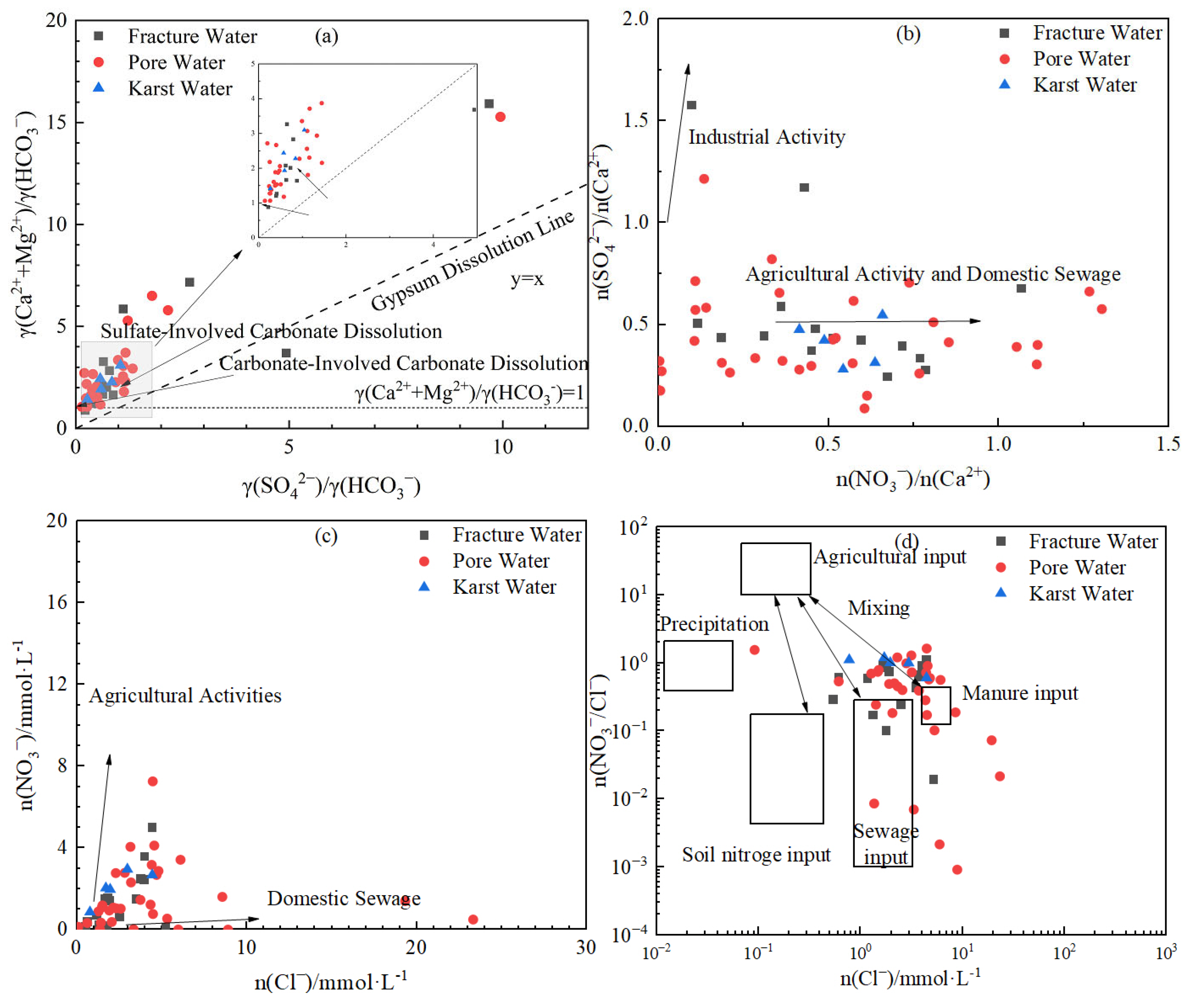
Natural processes govern baseline hydrochemistry: Rock weathering (calcite and dolomite dissolution) serves as the predominant ion source, while cation exchange plays a secondary role in shaping hydrochemical composition Notably, evaporation–concentration significantly elevates TDS in low-lying porous aquifers. Mineral saturation indices (SI) reveal higher dispersion in fractured groundwater (calcite SI: −1.5–1; dolomite SI: 0.5–−4), reflecting complex hydrodynamic controls, whereas porous and karst systems exhibit stable SI distributions (e.g., calcite SI: 0–1), indicating homogeneous chemical conditions.
(3)
Human activities alter hydrochemical evolution through dual pathways: Direct pollutant inputs—agricultural non-point sources and domestic wastewater (Cl, SO42−) are key anthropogenic contributors. Acid deposition (H2SO4, HNO3) enhances carbonate dissolution, elevating γ(SO42−)/γ(HCO3) to 0.3–0.6 in select samples. Hydrodynamic field modification—overexploitation-induced depression cones intensify inland salt accumulation and coastal seawater intrusion (Cl up to 4049.7 mg/L), reversing cation exchange direction (CAI > 0 in 67% of samples) and triggering Na+ enrichment with soil Ca2+/Mg2+ depletion.

Author Contributions

Conceptualization, X.W., M.L., Y.Y. and K.M.; methodology, M.L., X.W., Y.Y. and K.M.; software, X.W. and M.L.; validation, J.Y., Y.W. and M.Z.; formal analysis, X.W. and P.S.; investigation, M.L. and X.W.; resources, X.W., Y.Y. and J.Y.; data curation, K.M. and J.F.; writing—original draft preparation, M.L. and X.W.; writing—review and editing, M.L. and X.W.; supervision, M.L. and X.W.; project administration, M.L. and X.W.; funding acquisition, X.W. and Y.Y. All authors have read and agreed to the published version of the manuscript.

Funding

This research was funded by the Shandong Provincial Natural Science Foundation (No. ZR2022MD099), the Open Foundation of the Qingdao Key Laboratory of Groundwater Resources Protection and Rehabilitation (No. DXSKF2022Y04), the Qingdao Science and Technology Demonstration Project for Benefiting the People (No. 24-1-8-cspz-14-nsh), the Open Foundation of Key Laboratory of Geological Disaster Risk Prevention and Control of Shandong Provincial Emergency Management Department (No. 801KF2024-DZ07) and the Open Foundation of the Key Laboratory of Coupling Process and Effect of Natural Resources Elements (No. 2024KFKT017).

Institutional Review Board Statement

Not applicable.

Informed Consent Statement

Not applicable.

Data Availability Statement

The data presented in this study are available on request from the corresponding author due to project confidentiality and institutional policy restrictions.

Conflicts of Interest

The authors declare no conflicts of interest.

References

  1. Ren, C.; Zhang, Q. Groundwater Chemical Characteristics and Controlling Factors in a Region of Northern China with Intensive Human Activity. Multidiscip. Digit. Publ. Inst. 2020, 17, 9126. [Google Scholar] [CrossRef]
  2. Zhou, B.; Wang, H.; Zhang, Q. Assessment of the Evolution of Groundwater Chemistry and Its Controlling Factors in the Huangshui River Basin of Northwestern China, Using Hydrochemistry and Multivariate Statistical Techniques. Int. J. Environ. Res. Public Health 2021, 18, 7551. [Google Scholar] [CrossRef] [PubMed]
  3. Subba Rao, N.; Marghade, D.; Dinakar, A.; Chandana, I.; Sunitha, B.; Ravindra, B.; Balaji, T. Geochemical characteristics and controlling factors of chemical composition of groundwater in a part of Guntur district, Andhra Pradesh, India. Environ. Earth Sci. 2017, 76, 747. [Google Scholar] [CrossRef]
  4. Chen, Y.; Yang, S.; Dong, S.; Li, Y.; Sun, B.; Shao, Z. In Influence of Agricultural Activity and Aquifer Intrinsic Vulnerability on Groundwater Quality in the Dagu River Watershed (Qingdao, China). In Proceedings of the International Conference on Bioinformatics & Biomedical Engineering, Granada, Spain, 18–20 June 2010. [Google Scholar]
  5. Lin, M.-l.; Peng, W.-h.; Gui, H.-r. Hydrochemical characteristics and quality assessment of deep groundwater from the coal-bearing aquifer of the Linhuan coal-mining district, Northern Anhui Province, China. Environ. Monit. Assess. 2016, 188, 202. [Google Scholar] [CrossRef]
  6. Huang, G.; Liu, C.; Sun, J.; Zhang, M.; Jing, J.; Li, L. A regional scale investigation on factors controlling the groundwater chemistry of various aquifers in a rapidly urbanized area: A case study of the Pearl River Delta. Sci. Total Environ. 2018, 625, 510–518. [Google Scholar] [CrossRef]
  7. Mohamed, A.; Asmoay, A.; Alshehri, F.; Abdelrady, A.; Othman, A. Hydro-geochemical applications and multivariate analysis to assess the water–rock interaction in arid environments. Appl. Sci. 2022, 12, 6340. [Google Scholar] [CrossRef]
  8. Subba Rao, N.; Subrahmanyam, A.; Ravi Kumar, S.; Srinivasulu, N.; Babu Rao, G.; Rao, P.S.; Reddy, G.V. Geochemistry and quality of groundwater of Gummanampadu sub-basin, Guntur District, Andhra Pradesh, India. Environ. Earth Sci. 2012, 67, 1451–1471. [Google Scholar] [CrossRef]
  9. Srinivasamoorthy, K.; Vasanthavigar, M.; Vijayaraghavan, K.; Sarathidasan, R.; Gopinath, S. Hydrochemistry of groundwater in a coastal region of Cuddalore district, Tamilnadu, India: Implication for quality assessment. Arab. J. Geosci. 2013, 6, 441–454. [Google Scholar] [CrossRef]
  10. Marghade, D.; Malpe, D.B.; Subba Rao, N.; Sunitha, B. Geochemical assessment of fluoride enriched groundwater and health implications from a part of Yavtmal District, India. Hum. Ecol. Risk Assess. Int. J. 2020, 26, 673–694. [Google Scholar] [CrossRef]
  11. Yao-Qi, Z.; Zhen-Kai, Z.; Wen-Dong, L.; Su, L.; Hui-Wen, Y. Late Mesozoic tectono-magmatic activities and prototype basin restoration in Eastern Shandong Province, China. Earth Sci. Front. 2015, 22, 137. [Google Scholar]
  12. Luan, G.; Li, A.; Wang, J.; Li, G.; Xie, R.J. The geological origin division of the main sea island in Qingdao area and environment analysis. Period. Ocean Univ. China 2010, 40, 111–116. [Google Scholar]
  13. GB/T 14848-2017; Standard for Groundwater Quality. Chinese Standard: Beijing, China, 2017.
  14. Ma, Z.M.; Luo, Y.Y.; Fang, Y.Z.; Hou, Y.S. Hydrogeochemical mechanism of the petroleum hydrocarbon pollution in Karst Fissure groundwater system. Appl. Mech. 2013, 295, 159–163. [Google Scholar] [CrossRef]
  15. Kogovšek, J. Impact of chlorides, nitrates, sulfates and phosphates on increased limestone dissolution in the karst vadose zone (Postojna Cave, Slovenia). Acta Carsologica 2011, 40, 319–327. [Google Scholar] [CrossRef]
  16. Chunxia, M.; Xilai, Z.; Zhenyu, M.A.; Chengjian, W. Assessment on status of Nitrate pollution in rural water supply of Qingdao and its healthy risk. Water Resour. Hydropower Eng. 2014, 9, 24–26+38. [Google Scholar]
  17. Han, Z.; Ma, H.; Shi, G.; He, L.; Wei, L.; Shi, Q. A review of groundwater contamination near municipal solid waste landfill sites in China. Sci. Total Environ. 2016, 569–570, 1255–1264. [Google Scholar] [CrossRef]
  18. Gang, S.; Jia, T.; Deng, Y.; Xing, L.; Gao, S. Hydrochemical characteristics and formation mechanism of groundwater in Qingdao City, Shandong Province, China. Water 2023, 15, 1348. [Google Scholar] [CrossRef]
  19. Keim, D.M.; West, L.J.; Odling, N.E. Convergent Flow in Unsaturated Fractured Chalk. Vadose Zone J. 2012, 11, vzj2011-0146. [Google Scholar] [CrossRef]
  20. Rozell, D.J.; Reaven, S.J. Water Pollution Risk Associated with Natural Gas Extraction from the Marcellus Shale. Risk Anal. 2012, 32, 1382–1393. [Google Scholar] [CrossRef]
  21. Sidhu, J.S.; Chandel, S. Identification of hydrogeochemical processes affecting the hydrochemistry of groundwater: A review. J. Nat. Resour. Conserv. Manag. 2023, 4, 15–29. [Google Scholar] [CrossRef]
  22. Subramani, T.; Rajmohan, N.; Elango, L. Groundwater geochemistry and identification of hydrogeochemical processes in a hard rock region, Southern India. Environ. Monit. Assess. 2010, 162, 123–137. [Google Scholar] [CrossRef]
  23. Négrel, P.; Millot, R.; Petelet-Giraud, E.; Malcuit, E.; Brenot, A. Impact of Rock Weathering on the Chemical Composition of Groundwater Determined by Inverse Modeling in Large Sedimentary Basins. Procedia Earth Planet. Sci. 2013, 7, 615–619. [Google Scholar] [CrossRef]
  24. Zaidi, F.K.; Kassem, O.M.; Al-Bassam, A.M.; Al-Humidan, S. Factors governing groundwater chemistry in paleozoic sedimentary aquifers in an arid environment: A case study from Hail Province in Saudi Arabia. Arab. J. Sci. Eng. 2015, 40, 1977–1985. [Google Scholar] [CrossRef]
  25. Xie, Y.; Huang, F.; Yang, H.; Yu, S. Role of anthropogenic sulfuric and nitric acids in carbonate weathering and associated carbon sink budget in a karst catchment (Guohua), Southwestern China. J. Hydrol. 2021, 599, 126287. [Google Scholar] [CrossRef]
  26. Huang, Q.B.; Qin, X.Q.; Liu, P.Y.; Zhang, L.K.; Su, C.T. Impact of sulfuric and nitric acids on carbonate dissolution, and the associated deficit of CO2 uptake in the upper-middle reaches of the Wujiang River, China. J. Contam. Hydrol. 2017, 203, 18–27. [Google Scholar] [CrossRef]
  27. Liu, J.; Gao, Z.; Wang, M.; Li, Y.; Shi, M.; Zhang, H.; Ma, Y. Hydrochemical characteristics and possible controls in the groundwater of the Yarlung Zangbo River Valley, China. Environ. Earth Sci. 2019, 78, 76. [Google Scholar] [CrossRef]
  28. Szramek, K.; Walter, L.M.; Kandu, T.; Ogrinc, N. Dolomite Versus Calcite Weathering in Hydrogeochemically Diverse Watersheds Established on Bedded Carbonates (Sava and Soča Rivers, Slovenia). Aquat. Geochem. 2011, 17, 357–396. [Google Scholar] [CrossRef]
  29. Gomo, M. Conceptual hydrogeochemical characteristics of a calcite and dolomite acid mine drainage neutralised circumneutral groundwater system. Water Sci. 2018, 32, 355–361. [Google Scholar] [CrossRef]
  30. Möller, P.; De Lucia, M. The impact of Mg2+ ions on equilibration of Mg-Ca carbonates in groundwater and brines. Geochemistry 2020, 80, 125611. [Google Scholar] [CrossRef]
  31. Chidambaram, S.; Karmegam, U.; Sasidhar, P.; Prasanna, M.V.; Manivannan, R.; Arunachalam, S.; Manikandan, S.; Anandhan, P. Significance of saturation index of certain clay minerals in shallow coastal groundwater, in and around Kalpakkam, Tamil Nadu, India. J. Earth Syst. Sci. 2011, 120, 897–909. [Google Scholar] [CrossRef]
  32. Nagaraju, A.; Sreedhar, Y.; Kumar, K.S.; Thejaswi, A.; Sharifi, Z. Assessment of groundwater quality and evolution of hydrochemical facies around Tummalapalle area, Cuddapah District, Andhra Pradesh, South India. J. Environ. Anal. Chem. 2014, 1, 1000112. [Google Scholar]
  33. Santhanam, H.; Karthikeyan, A.; Raja, M. Saturation indices of aqueous mineral phases as proxies of seasonal dynamics of a transitional water ecosystem using a geochemical modeling approach. Model. Earth Syst. Environ. Earth Sci. 2021, 7, 1813–1829. [Google Scholar] [CrossRef]
  34. Yuan, J.; Xu, F.; Deng, G.; Tang, Y.; Li, P. Hydrogeochemistry of shallow groundwater in a karst aquifer system of Bijie City, Guizhou Province. Water 2017, 9, 625. [Google Scholar] [CrossRef]
  35. Duan, S.; Tong, T.; Zheng, S.; Zhang, X.; Li, S. Achieving low-cost, highly selective nitrate removal with standard anion exchange resin by tuning recycled brine composition. Water Res. 2020, 173, 115571. [Google Scholar] [CrossRef]
  36. Volkov, V.I.; Chernyak, A.V.; Golubenko, D.V.; Tverskoy, V.A.; Lochin, G.A.; Odjigaeva, E.S.; Yaroslavtsev, A.B. Hydration and diffusion of H+, Li+, Na+, Cs+ ions in cation-exchange membranes based on polyethylene-and sulfonated-grafted polystyrene studied by NMR technique and Ionic conductivity Measurements. Membranes 2020, 10, 272. [Google Scholar] [CrossRef]
  37. Zaidi, F.K.; Nazzal, Y.; Jafri, M.K.; Naeem, M.; Ahmed, I. Reverse ion exchange as a major process controlling the groundwater chemistry in an arid environment: A case study from northwestern Saudi Arabia. Environ. Monit. Assess. 2015, 187, 607. [Google Scholar] [CrossRef]
  38. Smith, C.; Oster, J.; Sposito, G.J.A.W.M. Potassium and magnesium in irrigation water quality assessment. Agric. Water Manag. 2015, 157, 59–64. [Google Scholar] [CrossRef]
  39. Jiang, Y. The contribution of human activities to dissolved inorganic carbon fluxes in a karst underground river system: Evidence from major elements and δ13CDIC in Nandong, Southwest China. J. Contam. Hydrol. 2013, 152, 1–11. [Google Scholar] [CrossRef]
  40. Ekklesia, E.; Shanahan, P.; Chua, L.; Eikaas, H. Associations of chemical tracers and faecal indicator bacteria in a tropical urban catchment. Water Res. 2015, 75, 270–281. [Google Scholar] [CrossRef]
  41. Cabral, A.C.; Stark, J.S.; Kolm, H.E.; Martins, C.C. An integrated evaluation of some faecal indicator bacteria (FIB) and chemical markers as potential tools for monitoring sewage contamination in subtropical estuaries. Environ. Pollut. 2018, 235, 739–749. [Google Scholar] [CrossRef] [PubMed]
  42. Sameer, V.; Hampannavar, U.; Purandara, B. Assessment of chloride concentration in groundwater: A case study for Belgaum City. Int. J. Environ. Sci. 2011, 2, 271–280. [Google Scholar]
  43. Yin, H.; Xie, M.; Zhang, L.; Huang, J.; Xu, Z.; Li, H.; Jiang, R.; Wang, R.; Zeng, X. Identification of sewage markers to indicate sources of contamination: Low cost options for misconnected non-stormwater source tracking in stormwater systems. Sci. Total Environ. 2019, 648, 125–134. [Google Scholar] [CrossRef] [PubMed]
  44. Jung, H.; Koh, D.-C.; Kim, Y.S.; Jeen, S.-W.; Lee, J. Stable isotopes of water and nitrate for the identification of groundwater flowpaths: A review. Water 2020, 12, 138. [Google Scholar] [CrossRef]
  45. Nisi, B.; Raco, B.; Dotsika, E. Groundwater contamination studies by environmental isotopes: A review. In Threats to the Quality of Groundwater Resources; Springer: Berlin/Heidelberg, Germany, 2016; pp. 115–150. [Google Scholar]
  46. Wang, H.; Zhang, Q. Research advances in identifying sulfate contamination sources of water environment by using stable isotopes. Int. J. Environ. Res. Public Health 2019, 16, 1914. [Google Scholar] [CrossRef] [PubMed]
  47. Ke, S.; Chen, J.; Zheng, X.; Sun, X. Reference ion method: A simple and fast method for quantitatively identifying the source of nitrate and denitrification rate in groundwater. Sci. Total Environ. 2021, 769, 144555. [Google Scholar] [CrossRef]
  48. Ji, X.; Xie, R.; Hao, Y.; Lu, J. Quantitative identification of nitrate pollution sources and uncertainty analysis based on dual isotope approach in an agricultural watershed. Environ. Pollut. 2017, 229, 586–594. [Google Scholar] [CrossRef]
  49. Minet, E.P.; Goodhue, R.; Meier-Augenstein, W.; Kalin, R.M.; Fenton, O.; Richards, K.G.; Coxon, C. Combining stable isotopes with contamination indicators: A method for improved investigation of nitrate sources and dynamics in aquifers with mixed nitrogen inputs. Water Res. 2017, 124, 85–96. [Google Scholar] [CrossRef]
  50. Hao, Z.; Zhang, X.; Gao, Y.; Xu, Z.; Yang, F.; Wen, X.; Wang, Y. Nitrogen source track and associated isotopic dynamic characteristic in a complex ecosystem: A case study of a subtropical watershed, China. Environ. Pollut. 2018, 236, 177–187. [Google Scholar] [CrossRef]
  51. Li, J.; Cao, R.; Lao, Q.; Chen, F.; Chen, C.; Zhou, X.; Meng, Y.; Zhu, Q. Assessing seasonal nitrate contamination by nitrate dual isotopes in a monsoon-controlled bay with intensive human activities in South China. Int. J. Environ. Res. Public Health 2020, 17, 1921. [Google Scholar] [CrossRef]
  52. Mu, D.; Li, P.; De Baets, B.; Li, D.; Li, Z.; He, S. A multi-perspective exploration of the salinization mechanisms of groundwater in the Guanzhong Basin, China. Sci. Total Environ. 2024, 957, 177421. [Google Scholar] [CrossRef]
  53. Essien, E.E.; Said Abasse, K.; Côté, A.; Mohamed, K.S.; Baig, M.M.F.A.; Habib, M.; Naveed, M.; Yu, X.; Xie, W.; Jinfang, S. Drinking-water nitrate and cancer risk: A systematic review and meta-analysis. Arch. Environ. Occup. Health 2022, 77, 51–67. [Google Scholar] [CrossRef]
  54. Hosseini, F.; Majdi, M.; Naghshi, S.; Sheikhhossein, F.; Djafarian, K.; Shab-Bidar, S. Nitrate-nitrite exposure through drinking water and diet and risk of colorectal cancer: A systematic review and meta-analysis of observational studies. Clin. Nutr. 2021, 40, 3073–3081. [Google Scholar] [CrossRef] [PubMed]
  55. Stayner, L.T.; Schullehner, J.; Semark, B.D.; Jensen, A.S.; Trabjerg, B.B.; Pedersen, M.; Olsen, J.; Hansen, B.; Ward, M.H.; Jones, R.R. Exposure to nitrate from drinking water and the risk of childhood cancer in Denmark. Environ. Int. 2021, 155, 106613. [Google Scholar] [CrossRef] [PubMed]
Figure 1. Overview of the study area and distribution diagram of sampling points.
Sustainability 17 05988 g001
Figure 2. Distribution of hydrochemical characteristics of various groundwater types in the study area (a) Concentration range of conventional ions in groundwater; (b) Total dissolved solids (TDSs) range in groundwater; (c) Nitrate concentration range.
Sustainability 17 05988 g002
Figure 3. Durov diagram of various types of groundwater in the study area.
Sustainability 17 05988 g003
Figure 4. The spatial distribution characteristics of water chemicals in the study area.
Sustainability 17 05988 g004
Figure 5. Gibbs diagram of various types of groundwater in the study area: (a) Relationship between cation ratios and TDS; (b) Relationship between anion ratios and TDS.
Sustainability 17 05988 g005
Figure 6. Hydrochemical diagenetic and weathering characteristics: (a) Relationship between n(Ca2+)/n(Na+) and n(Mg2+)/n(Na+); (b) Relationship between n(Ca2+)/n(Na+) and n(HCO3)/n(Na+).
Sustainability 17 05988 g006
Figure 7. Main ion ratio relationship diagram: (a) γ(Na++K+) vs. γ(Cl) ionic ratio, (b) γ(Ca2+ + Mg2+) vs. γ(HCO3 + SO42−) ionic ratio, and (c) γ(Ca2+)/γ(Mg2+) vs. γ(HCO3) ionic ratio.
Sustainability 17 05988 g007
Figure 8. Mineral saturation index diagram of different types of groundwater.
Sustainability 17 05988 g008
Figure 9. Cation exchange degree (a) and chloro-alkali index diagrams (b).
Sustainability 17 05988 g009
Figure 10. Characteristic diagram of the impact of human activities on groundwater hydrochemical components: (a) γ (Ca2+ + γ(Mg2+) vs. γ(HCO3); (b) n(SO42−)/n(Ca2+) vs. n(NO3/Ca2+); (c) n(NO3) vs. n(Cl); (d) n(NO3/Cl) vs. n(Cl).
Sustainability 17 05988 g010
Figure 11. Distribution of contribution rates of major ions to different pollution factors in groundwater: (a) pore water; (b) fissure water; (c) karst water (Red: Potassium ion (K+); Blue: Sodium ion (Na+); Green: Calcium ion (Ca2+); Purple: Magnesium ion (Mg2+); Yellow-brown: Chloride ion (Cl); Sky blue: Sulfate ion (SO42−); Brown: Bicarbonate (HCO3); Olive green: Nitrate (NO3)).
Sustainability 17 05988 g011
Table 1. Mathematical statistics of hydrochemical characteristics of groundwater in the study area.
ClassificationProjectpHTDSK+Na+Ca2+Mg2+ClSO42−HCO3NO3-N
Pore water n = 36Max8.48203.549.61805.1769.2342.74049.71089.2842.2101.7
Min6.9161.10.312.631.74.73.321.123.20.1
Mean7.7716.64.169.9134.427.7123.0122.4256.123.2
Std0.41660.910.5413.3138.977.1826.3245.2167.521.9
CV0.061.291.61.990.821.412.081.160.581.06
Fracture water = 20Max8.31224.87.1139.3261.150.7186.1221.7444.370.1
Min7.0147.70.516.714.70.719.330.00.01.4
Mean7.6562.22.961.499.718.690.5106.7167.020.4
Std0.7275.21.833.465.612.750.855.3126.519.2
CV0.10.490.610.540.660.660.560.520.760.94
Karst water = 6Max7.74551.530.384.61143.5220.41934.1382.2475.5121.0
Min7.1361.10.414.683.313.927.594.9142.612.1
Mean7.5743.510.145.9314.968.2392.5182.5335.344.7
Std0.21431.310.120.9372.069.4690.697.8117.835.4
CV0.021.041.000.461.181.021.760.540.350.79
Max represents the maximum value; represents the standard deviation; CV represents the coefficient of variation; pH is dimensionless, and the units for other components are mg/L.
Disclaimer/Publisher’s Note: The statements, opinions and data contained in all publications are solely those of the individual author(s) and contributor(s) and not of MDPI and/or the editor(s). MDPI and/or the editor(s) disclaim responsibility for any injury to people or property resulting from any ideas, methods, instructions or products referred to in the content.

