Article

Integrating UAV Photogrammetry and GIS to Assess Terrace Landscapes in Mountainous Northeastern Türkiye for Sustainable Land Management

by
Ayşe Karahan
1,
Oğuz Gökçe
2,3,
Neslihan Demircan
4,*,
Mustafa Özgeriş
1 and
Faris Karahan
1
1
Department of Landscape Architecture, Architecture and Design Faculty, Atatürk University, Erzurum 25240, Turkey
2
Department of Garden Agriculture, Baskil Vocational School, Fırat University, Elazığ 23119, Turkey
3
Department of Landscape Architecture, Graduate School of Natural and Applied Sciences, Atatürk University, Erzurum 25240, Turkey
4
Department of Architecture, Architecture and Design Faculty, Atatürk University, Erzurum 25240, Turkey
*
Author to whom correspondence should be addressed.
Sustainability 2025, 17(13), 5855; https://doi.org/10.3390/su17135855 (registering DOI)
Submission received: 27 April 2025 / Revised: 10 June 2025 / Accepted: 12 June 2025 / Published: 25 June 2025
(This article belongs to the Section Sustainable Management)

Abstract

Agricultural terraces are critical landscape elements that promote sustainable rural development by enhancing water retention, mitigating soil erosion, and conserving cultural heritage. In northeastern Türkiye, particularly in the mountainous Erikli neighborhood of Uzundere, traditional terraces face growing threats due to land abandonment, topographic fragility, and socio–economic decline. This study applies a spatial–functional assessment framework that integrates UAV–based photogrammetry, GIS analysis, terrain modeling, and DBSCAN clustering to evaluate terrace conditions. UAVs provided high–resolution topographic data, which supported the delineation of terrace boundaries and morphometric classification using an adapted ALPTER model. A combined Terrace Density Index (TDI) and Functional Status Index (FSI) approach identified zones where terraces are structurally intact but functionally degraded. Results indicate that 76.4% of terraces fall within the meso and macro classes, yet 58% show partial or complete degradation. Cohesive terrace clusters are located near settlements, while isolated units in peripheral zones display higher vulnerability. This integrated approach demonstrates the analytical potential of drone–supported spatial diagnostics for monitoring landscape degradation. The method is scalable and adaptable to other terraced regions, offering practical tools for site–specific land use planning, heritage conservation, and resilience–based restoration strategies.

1. Introduction

Agricultural terraces have long played a vital role in sustainable land use practices in mountainous regions. By converting steep slopes into cultivable plots, terraces mitigate erosion, conserve water, and support long-term human habitation in ecologically sensitive landscapes [1,2]. These systems function as multifunctional landscape infrastructures, delivering provisioning, regulating, and cultural ecosystem services, making them critical to global efforts toward land degradation neutrality, biodiversity protection, and rural revitalization [3,4].
Terraced landscapes are increasingly recognized within sustainability science as coupled socio-ecological systems and biocultural heritage assets, embodying a long-standing co-evolution of environmental stewardship and traditional knowledge transmission [5,6,7]. This dual character aligns with integrative frameworks in landscape resilience and climate-adaptive agriculture, especially in areas facing marginality and ecological fragility [8,9,10].
Yet, despite their multifaceted value, traditional terraces face mounting threats including rural outmigration, labor shortages, mechanization constraints, and climatic uncertainties. Across much of Europe and Asia, abandonment has triggered hydrological instability, vegetation shifts, and accelerated soil erosion [11,12]. Crucially, the disappearance of terraces represents not only physical degradation but also a rupture in place-based identities, collective memory, and community-level governance of land [6,13].
International frameworks such as the FAO’s Globally Important Agricultural Heritage Systems (GIAHS) have promoted integrated conservation through participatory, community-based mechanisms [2]. These initiatives frame terraces as living landscapes—adaptive systems where traditional ecological knowledge (TEK) and agroecosystem services mutually reinforce one another [14]. However, operational challenges remain in identifying, monitoring, and mainstreaming terraces into national planning, land use policy, and sustainability indicators.
The connection between agricultural terraces and the United Nations Sustainable Development Goals (SDGs) is both substantial and multifaceted yet remains operationally underexplored in the policy and planning literature. Terraces directly contribute to SDG 2 (Zero Hunger) by maintaining agricultural productivity on ecologically fragile, sloped terrains, to SDG 11 (Sustainable Cities and Communities) by preserving traditional cultural landscapes and local identities, and to SDG 15 (Life on Land) through mitigating soil erosion, enhancing soil fertility, and sustaining biodiversity [2,4,9,15]. However, the potential of terraces to support these goals is often limited by the lack of spatially explicit data and integration into national development agendas [16].
Recent advancements in geospatial technologies—particularly UAV-based photogrammetry, high-resolution digital elevation models (DEMs), GIS-based classification, and satellite-derived indices—have enabled researchers to accurately map, quantify, and monitor terraces across diverse landscapes [5,10,17]. These tools offer high spatial and temporal precision, facilitating assessments of terrace density, spatial configuration, and vulnerability. Such data-driven insights are essential for optimizing sustainable land management strategies under scenarios of land abandonment, demographic pressure, and climate risk [18].
In light of these opportunities, there is a growing imperative to integrate technical, ecological, and cultural dimensions in the spatial assessment of terraced systems—particularly in underrepresented and ecologically sensitive rural contexts. Multidimensional assessments allow for more nuanced landscape typologies and intervention frameworks that can simultaneously preserve landscape integrity and enhance community resilience. This integrated approach also aligns with transdisciplinary paradigms of nature-based solutions (NBSs) and ecosystem-based adaptation (EbA), reinforcing the role of terraces as climate-adaptive rural infrastructures.

1.1. Agricultural Terraces, Rural Development, and the SDGs

Agricultural terraces represent not only structural adaptations to mountainous landscapes but also socio-ecological systems that interweave ecological resilience, food security, and cultural identity. Functioning as multifunctional landscape infrastructures, terraces enhance soil stability, modulate hydrological cycles, and mitigate erosion—critical elements for sustainable agricultural livelihoods, especially in marginal rural areas [11,12,19]. Beyond their physical utility, terraces embody centuries of place-based knowledge, community labor organization, and adaptive responses to topographic and climatic constraints [20,21].
Historically, terraces have been central to land management strategies across the Mediterranean, East Africa, Southeast Asia, and the Andes. These systems support smallholder farming by maximizing arable space on steep terrain without reliance on mechanization, making them especially relevant in economically constrained but ecologically sensitive rural regions [13,14,22]. The Andes, for instance, demonstrate millennia-old terrace systems designed for microclimatic control and altitudinal cropping, while the Ethiopian highlands and Himalayan foothills showcase cooperative maintenance practices linked to social cohesion and equitable water distribution [23,24,25].
As such, agricultural terraces contribute directly to the realization of several United Nations Sustainable Development Goals (SDGs) by delivering both ecological services and socio-cultural functions. SDG 2 (Zero Hunger) is reinforced through terraces’ capacity to sustain food production on marginal slopes, reduce the vulnerability of smallholder farming to climatic stress, and preserve agro-biodiversity in traditional cropping systems [17,26,27]. SDG 11 (Sustainable Cities and Communities) is supported by the conservation of cultural landscapes and embedded traditional ecological knowledge (TEK), which strengthens community identity and continuity [18,21]. Likewise, terraces advance SDG 15 (Life on Land) by mitigating soil erosion, enhancing soil fertility, supporting pollinator networks, and preserving habitat connectivity across fragmented rural terrains [19,20,28].
Beyond their biophysical functions, terraces serve as socio-cultural systems shaped by historical governance practices, communal labor arrangements, and seasonal land use rituals. These components represent a form of biocultural governance, where cultural traditions and ecological knowledge co-evolve and inform land stewardship decisions [22,29]. In contemporary rural development frameworks, such heritage-based governance is increasingly viewed as a critical dimension of place-based sustainability and community resilience, particularly under conditions of demographic change and climate uncertainty [23,30].
Despite these values, many terraced landscapes are facing degradation due to outmigration, labor shortages, and reduced public investment in maintenance. These dynamics threaten both ecological functions and rural economic viability, resulting in increased exposure to hazards such as landslides and runoff. Consequently, integrated policy strategies now advocate for multifunctional conservation models that link remote sensing, participatory planning, and agri-environmental incentives. Instruments such as Payments for Ecosystem Services (PES), cross-sectoral planning platforms, and landscape-level governance schemes have emerged as effective approaches for sustaining traditional terraces within modern sustainability agendas [25,26,31,32].
Terraced landscapes can also serve as foundational elements in nature-based solutions (NBSs) aimed at climate adaptation, water retention, soil stabilization, and disaster risk reduction. Their vegetated structures and hydrological functions provide ecological buffers against landslides, flash floods, and droughts—particularly in mountainous and semi-arid regions [21,33]. When supported by spatial data and participatory governance, terraces align closely with SDG-oriented territorial planning, especially under frameworks that promote resilience-based land use strategies [34,35].
To ensure their long-term viability, the preservation and revitalization of terrace systems demand cross-sectoral policy integration—bridging agriculture, cultural heritage, water resource management, and rural tourism sectors. Such integrated approaches foster synergy between environmental and socio-economic objectives and have been effectively implemented in diverse contexts, from the Mediterranean to Southeast Asia [36,37].
In this light, terraces must not be viewed solely as historical artifacts or conservation liabilities but as active instruments of sustainable rural transformation. They embody the complex co-evolution of humans and landscapes—representing adaptive systems where social memory, environmental design, and functional land use converge to create resilience. Embracing this perspective is essential for formulating inclusive, future-oriented rural development policies under changing socio-ecological conditions [38,39,40]. Despite the demonstrated alignment between agricultural terraces and multiple SDGs, several structural and contextual barriers constrain the full realization of their contributions. These barriers include insufficient financial incentives for terrace maintenance, fragmented land tenure systems that limit collective stewardship, and the gradual erosion of traditional ecological knowledge in many rural areas. Additionally, the limited integration of terraced landscapes into national rural development frameworks and the absence of standardized spatial data infrastructures hinder evidence-based policymaking. Without addressing these systemic constraints—particularly in contexts of rural outmigration, policy fragmentation, and institutional invisibility—the transformative potential of terraces for supporting SDG 2 (Zero Hunger), SDG 11 (Sustainable Cities and Communities), and SDG 15 (Life on Land) will remain significantly underutilized.

1.2. International Perspectives on Terrace Systems

Terraced agricultural landscapes constitute a globally shared yet regionally distinct form of land use adaptation that has evolved over centuries in response to environmental pressures, socio-economic demands, and cultural practices. As culturally embedded socio-ecological infrastructures, terraces offer not only slope stabilization and water management but also serve as repositories of traditional knowledge, communal labor systems, and aesthetic landscape values [11,28]. Globally, terrace systems manifest in highly diverse typologies—ranging from water-intensive rice terraces in East and Southeast Asia to dry-stone viticultural terraces along the Mediterranean coast and high-altitude stepped potato fields in the Andes [30,41,42]. These varied forms reflect localized strategies of environmental stewardship under differing climatic, geomorphic, and historical conditions.
Recent global reviews have emphasized that terraced systems represent a spectrum of multifunctional land use patterns—from irrigated rice-based agro-ecosystems (e.g., the Hani terraces of Yunnan) to mixed silvo-agricultural mosaics in Southern Europe and arid-zone micro-irrigation structures in the Middle East and North Africa [43,44]. Despite their diverse forms, they share a unifying logic: the transformation of sloped terrain into sustainable, human—nature co-produced landscapes. This functional unity embedded in cultural heterogeneity makes terraces emblematic of regional resilience, adaptive design, and biocultural continuity [6,45].
In East Asia, and particularly in China, agricultural terraces form the backbone of mountainous agri-cultural systems, serving as high-functioning landscapes that merge ecological engineering with cultural heritage. The Honghe Hani Rice Terraces in Yunnan Province—recognized as both a UNESCO World Heritage Site and a FAO-designated Globally Important Agricultural Heritage System (GIAHS)—represent a sophisticated example of integrated forest-water-rice cultivation systems [28,46]. These terraces support simultaneous provisioning (rice and livestock), regulating (runoff control, flood moderation), cultural (ethnic minority identity, aesthetic value), and supporting (soil formation, pollination) ecosystem services [47,48].
Multifunctionality in these systems is rooted in their vertical ecological zoning: upper forest zones secure water infiltration, mid-slope terraces regulate flow and retain soil, and lower wetlands support aquatic diversity [49]. However, recent studies reveal increasing vulnerability due to youth outmigration, mechanization constraints on narrow slopes, and shifting precipitation regimes linked to climate change [50]. In response, regional policies have begun to implement Payments for Ecosystem Services (PES) schemes and heritage-linked agrotourism models to incentivize local stewardship and intergenerational knowledge transfer [51]. These efforts align terrace conservation with broader sustainability transitions in rural China.
In the Mediterranean region, dry-stone terraced landscapes are widely distributed along steep coastal and interior slopes, particularly in Italy, Greece, and Spain. These centuries-old structures serve dual ecological and cultural roles—stabilizing slopes and preventing runoff while also embodying regional identity, aesthetic value, and intangible cultural heritage [5,6]. In Italy, the terraced hillsides of Liguria and Amalfi have been recognized under national landscape protection laws and UNESCO’s cultural landscapes framework for their unique integration of agricultural functionality and visual character [52,53].
In Spain, particularly in Galicia and Asturias, the abandonment of terraces has led to severe vegetation encroachment, altered wildfire regimes, and erosion of collective land use memory [29,54]. Field studies indicate that the cessation of traditional practices has reduced fire breaks and increased scrub fuel loads, contributing to heightened fire vulnerability [55]. This degradation is largely driven by agricultural marginalization, rural depopulation, and land tenure fragmentation—trends common across Mediterranean Europe [7]. As a response, regional programs under EU agri-environmental schemes and the Natura 2000 network have begun offering subsidies and legal frameworks to incentivize terrace maintenance as part of biodiversity and heritage conservation [56,57].
In Latin America, the Andean highlands present one of the most enduring and sophisticated cases of terraced agriculture, rooted in indigenous knowledge systems that have persisted for millennia. Communities such as the Quechua and Aymara developed intricate terracing networks to manage water distribution, control soil temperature, and regulate microclimates across steep, arid slopes [30,58]. These systems allowed for the cultivation of tubers, grains, and legumes at various altitudinal levels, enhancing food security and ecological buffering in fragile environments [59].
Today, Andean terraces are central to agroecological transition frameworks, where traditional ecological knowledge (TEK) is combined with modern conservation agriculture to promote sustainable intensification without chemical dependence [60]. However, recent studies highlight growing challenges, including policy fragmentation, loss of customary tenure, and minimal state investment, which collectively erode the resilience of these landscapes [61]. In response, community-based governance models—such as ayllu-based decision-making and NGO-led participatory restoration initiatives—have emerged as viable strategies for revalorizing terrace systems and integrating them into climate adaptation agendas [62].
In Mexico, regions such as Zacatecas and Oaxaca illustrate how terraced landscapes are increasingly assessed through landscape metrics, satellite imagery, and high-resolution digital elevation models to quantify abandonment, erosion risk, and land cover change. Studies applying indices like NDVI (Normalized Difference Vegetation Index), slope stability metrics, and spatial fragmentation analyses have revealed stark patterns of terraced land degradation, particularly in rainfed and semi-arid subregions [27,63,64]. These findings not only map physical transformations but also highlight underlying drivers such as mechanization barriers, rural depopulation, and contested land tenure.
Participatory conservation approaches have been proposed in response, including community mapping, traditional land use zoning, and ejido-based co-management schemes, which incorporate both remote sensing outputs and local ecological knowledge (LEK) [65]. However, modernization pressures often conflict with these efforts. Large-scale infrastructure projects, top-down agricultural subsidies, and migration-related land revaluation continue to erode terrace maintenance practices [66]. These experiences in Mexico expose the persistent structural tensions between top-down modernization models and community-based conservation while also offering inspiring models for co-productive restoration in mountainous regions.
Comparative analysis across global case studies reveals a recurring pattern: while the ecological and heritage values of terraced landscapes are broadly acknowledged, their long-term maintenance and restoration depend critically on sustained socio-political support. This includes robust institutional arrangements, targeted financial mechanisms, and culturally embedded participatory processes [1,12,27,67]. Successful initiatives often converge around three interdependent pillars: (1) community empowerment through recognition of customary rights and inclusion in planning, (2) policy alignment with agroecological principles that integrate biodiversity and local knowledge, and (3) financial instruments such as Payments for Ecosystem Services (PES) that incentivize conservation-compatible land uses [68,69].
These insights reinforce the view that terraces are not obsolete remnants of the past but resilient landscape infrastructures capable of anchoring sustainability transitions—particularly in contexts of climate vulnerability and rural transformation. However, unlocking this potential requires transdisciplinary planning approaches that bridge ecology, cultural heritage, land economics, and environmental governance [70]. Such frameworks promote co-learning among scientists, policymakers, and local communities and enable dynamic landscape governance models that are adaptable, inclusive, and future-oriented [71].

1.3. Terrace Landscapes in Türkiye: Challenges and Research Gaps

While global research on terraced landscapes has expanded over the past two decades—particularly in regions such as China, the Andes, and the Mediterranean—few studies have addressed the Turkish context through high-resolution geospatial methods. Most research in Türkiye remains descriptive or localized, often based on visual interpretation and lacking standardized spatial indicators. Nevertheless, valuable contributions exist; for instance, Balta and Atik analyzed the historical and archaeological structure of agricultural terraces in Selge using spatial and landscape approaches [72,73], while Özgeriş and Karahan examined the cultural landscape identity and terrace knowledge traditions of Uzundere through an ethnographic lens [71,74]. Additional studies such as Eşler’s landscape planning evaluation of Bozburun Peninsula emphasize the aesthetic and functional deterioration of abandoned terraces but fall short in spatial diagnostic modeling [75]. These examples highlight a scattered and methodologically diverse research base. In response, this study applies UAV-based photogrammetry and DBSCAN clustering to produce a replicable, fine-scaled model for identifying terrace morphology, spatial density, and functional degradation. Applied in the ecologically fragile and Cittaslow-recognized Uzundere district, this method addresses an urgent analytical and policy gap, supporting data-driven approaches to landscape resilience and cultural heritage governance.
Türkiye hosts a rich diversity of terraced landscapes shaped by its complex topography, diverse climatic zones, and long-standing agrarian traditions. From the humid slopes of the eastern Black Sea (notably in Rize and Artvin) to the semi-arid uplands of eastern Anatolia (e.g., Erzurum and Bayburt) and the Mediterranean coastal terraces of the Aegean region, terracing has historically enabled local communities to adapt to steep terrains while managing soil stability and water resources effectively [6,31,76]. These systems function not only as erosion control infrastructures but also as biocultural landscapes that reflect centuries of local environmental knowledge and rural livelihoods [5,77].
Despite their ecological and cultural significance, traditional terraces in Türkiye remain significantly underrepresented in national land use legislation, spatial planning policies, and academic research. The absence of formal recognition or inventorying has contributed to widespread abandonment, particularly in remote and demographically shrinking regions. In areas such as Rize and Bayburt, stone-walled terraces that once supported tea cultivation, hazelnuts, and localized horticulture have experienced a marked decline due to rural outmigration, labor shortages, and land fragmentation. Field observations and recent satellite-based land use assessments reveal a decline of up to 30% in active terrace coverage over the last two decades, often accompanied by slope instability and biodiversity loss [31,33,78].
The abandonment of terraced landscapes in Türkiye has been directly associated with increased surface runoff, gully formation, landslide incidence, and slope instability, particularly in areas where terrace walls have collapsed or where spontaneous vegetation succession replaces managed land cover [31,78]. These physical changes disrupt hydrological regulation, reduce infiltration capacity, and accelerate erosion processes, especially in steep and semi-arid contexts [79]. Moreover, ecological degradation is frequently compounded by the erosion of traditional ecological knowledge (TEK)—a body of locally embedded, intergenerationally transmitted knowledge systems that guide practices such as dry-stone walling, seasonal rotation, and vegetation selection [5,6,80].
The disappearance of terraces often entails a breakdown in community-based landscape governance, disrupting adaptive feedback loops between land users and ecological systems. These ruptures result not only in the loss of physical integrity but also in the erosion of social memory, place identity, and long-term adaptive capacity—factors essential for sustaining restoration efforts [81]. Empirical studies emphasize that interventions which fail to integrate traditional ecological knowledge (TEK) tend to produce temporary outcomes, often failing to reactivate local stewardship and leading to rapid post-restoration degradation [82].
In Türkiye, a major structural impediment to terrace preservation is the absence of a national inventory, classification standard, or integrated monitoring system. Although some terraced areas may be administratively recognized as “agricultural land” under the 5403 Soil Protection and Land Use Law, this status is inconsistently applied across provincial borders, creating regulatory fragmentation [25,83]. Terraces are rarely incorporated into rural development frameworks, regional spatial plans, biodiversity action plans, or agri-environmental payment schemes, leading to institutional invisibility [84]. Unlike the EU’s cross-compliance mechanisms under the Common Agricultural Policy (CAP), Türkiye lacks legal tools or incentive-based policies (e.g., PES, heritage zoning) that would align ecological, cultural, and economic functions in terraced landscapes [85].
As a result, policy fragmentation hampers inter-ministerial coordination (e.g., between Ministries of Agriculture, Environment, and Culture) and leads to jurisdictional ambiguities that block landscape-scale conservation. Addressing these issues requires not only legal reform but also the integration of cross-sectoral governance models, such as landscape contracts, heritage-led rural development, and spatially explicit agroecological planning [86].
Unlike European countries where cross-compliance mechanisms and Payments for Ecosystem Services (PES) play a central role in sustaining traditional landscapes, Türkiye currently lacks an operational framework that incentivizes the restoration or continued use of terraced fields [19,25]. For instance, in Italy and Spain, PES schemes are often embedded within rural development programs and landscape-level agri-environmental contracts, offering financial compensation to farmers who maintain historical terraces as part of biodiversity and erosion control measures [85,87]. In contrast, Türkiye does not provide either policy instruments or fiscal incentives that recognize terraces as multifunctional infrastructures or as part of rural cultural heritage.
Furthermore, the methodological approach to terrace research in Türkiye remains largely descriptive, fragmented, and scale-limited. Most existing studies are based on photographic interpretation, field observation, or semi-structured interviews, with minimal use of high-resolution or geospatial techniques [5,33,88]. Although a few pioneering efforts have begun integrating UAV photogrammetry and GIS clustering, they are often restricted to case-based academic theses or exploratory mapping exercises, lacking standardized metrics or spatial comparability frameworks [89].
This study addresses these methodological and policy gaps by implementing an integrated, drone-supported spatial analysis of terraced landscapes in northeastern Türkiye. Specifically, it combines UAV-derived orthophotos, slope- and area-based classification, and DBSCAN clustering algorithms to produce standardized spatial indicators of terrace morphology, distribution, and density. These indicators are not only useful for visualizing landscape patterns and identifying vulnerable zones but also provide a globally comparable, data-driven baseline to support evidence-based conservation, land use planning, and rural policy design. In this sense, the study contributes to both academic discourse and policy practice, offering a scalable model that aligns with international standards in sustainability science and landscape governance.
The primary aim of this study is to assess the spatial structure, typology, and distribution of agricultural terraces in a mountainous rural landscape in northeastern Türkiye—specifically in the Uzundere district of Erzurum Province. This area represents an ecologically fragile and demographically shrinking zone where terrace abandonment has intensified over the past two decades, resulting in significant land degradation and cultural erosion [33,88]. The study responds to critical data and policy gaps in the Turkish context by producing high-resolution, spatially explicit indicators that can guide both academic inquiry and land use planning practices.
Using Unmanned Aerial Vehicle (UAV)-based photogrammetry combined with Geographic Information Systems (GIS), the research captures terrace-related spatial variables including density index, morphological classification, and clustering patterns. UAV imagery enables centimeter-level resolution, allowing for the precise delineation of terrace edges, retaining walls, and degraded sections—features often overlooked by traditional mapping or coarse satellite imagery [89]. These spatial indicators offer a quantitative baseline for evaluating the structural integrity and landscape coherence of traditional terrace systems. Moreover, they support the identification of vulnerability hotspots and restoration priorities under conditions of climatic variability and changing land use dynamics [90].
By bridging technical analysis with policy-relevant outcomes, this study aims to support the evidence-based integration of terraced landscapes into environmental planning, agri-environmental policy, and heritage conservation strategies. The proposed framework aligns with the operational goals of SDG 2 (Zero Hunger), SDG 11 (Sustainable Cities and Communities), and SDG 15 (Life on Land) by enhancing landscape-level resilience, food system integrity, and cultural continuity [91,92,93].
Methodologically, the study introduces an integrated geospatial analysis that combines high-resolution UAV-based photogrammetry, slope- and area-based terrain classification, and density-based spatial clustering (DBSCAN algorithm) to classify terrace units into morpho-functional types. DBSCAN—a non-parametric, noise-tolerant clustering method—offers an advantage over traditional Euclidean techniques by identifying spatially coherent terrace clusters of irregular shape and varying density without requiring the prior input of a cluster number [94]. This is particularly suitable for mountainous terrains with fragmented and heterogenous landscape units.
The multidimensional nature of the approach—encompassing topographic modeling, spatial metrics, and morphological segmentation—enables a nuanced understanding of how terrace systems are embedded within ecological boundaries, slope categories, and socio-spatial configurations. It also allows for the localization of vulnerability hotspots (e.g., collapsed walls, erosion-prone slopes), which are essential for designing targeted restoration strategies.
In the context of Türkiye—where terrace-related research has largely relied on visual interpretation and qualitative mapping—this study provides a replicable, quantitative spatial methodology that meets international scientific standards while remaining sensitive to regional geomorphological variation and cultural landscape typologies [5,6,33,95,96]. This methodological advance helps establish a scalable foundation for integrating remote sensing data into local and regional planning processes, facilitating informed decision-making for both conservation and development.
From a policy standpoint, this study helps close a persistent data–policy disconnect in Türkiye, where no centralized inventory or national-scale mapping initiative for terraced landscapes currently exists [25,97]. This lack of spatial intelligence hinders integrated conservation planning, disaster risk assessment, and agro-environmental program design. By producing visual, spatially referenced, and high-resolution geodata, the research contributes directly to evidence-based environmental planning, land use policy formulation, and heritage-led rural development strategies at both municipal and regional levels [98].
The study also aligns with the United Nations Sustainable Development Goals (SDGs) by advancing landscape-level tools and diagnostics. Specifically, it enhances the following:
SDG 2 (Zero Hunger) through better identification of cultivable marginal lands and productivity monitoring,
SDG 11 (Sustainable Cities and Communities) via documentation of rural cultural heritage and landscape functionality,
SDG 15 (Life on Land) by supplying spatial indicators essential for erosion control, biodiversity planning, and ecological integrity [2,4,9,99].
In summary, the study makes the following key contributions:
It pioneers the first UAV-GIS-DBSCAN-based assessment of terraced landscapes in northeastern Türkiye, providing a replicable spatial methodology.
It bridges a significant methodological and geographical gap in the national and regional literature on terraced systems.
It offers a practical framework that connects spatial metrics to conservation planning, policy targeting, and vulnerability assessments.
It enhances international comparability by aligning the approach with global standards in landscape mapping and sustainability monitoring.

2. Materials and Methods

2.1. Methodological Framework and Rationale

The methodological design of this study is grounded in an integrative, multi-scale spatial analysis framework that seeks to quantify the current condition and spatial organization of traditional agricultural terraces in northeastern Türkiye. This approach is rooted in the recognition of terraced landscapes as socio-ecological systems, where spatial patterns encapsulate cumulative interactions between historical land use strategies, ecological adaptation, and governance shifts [100]. Understanding such landscapes necessitates a method that can simultaneously detect morphometric variation and spatial distribution dynamics. This conceptual integration bridges the disciplinary divide between geomatics and landscape governance, allowing terraced landscapes to be assessed as dynamic infrastructures rather than static landforms.
Recent advancements in geospatial technologies have significantly enhanced our ability to monitor and interpret terraced landscapes, particularly in steep, fragmented, or data-poor environments [101,102]. UAV-based photogrammetry provides ultra-high-resolution imagery capable of capturing subtle surface morphology, while Geographic Information Systems (GIS) facilitate the classification, measurement, and visualization of landscape metrics. This synergy between UAVs and GIS ensures both precision and scalability—two foundational requirements for effective landscape-scale sustainability assessment [103]. In this study, UAVs serve exclusively as data acquisition platforms, whereas spatial diagnostics and classification processes are entirely conducted within the GIS domain, ensuring methodological clarity and analytical rigor.
In this study, UAV photogrammetry is employed to generate orthomosaics and digital elevation models (DEMs) of the target area, enabling high-resolution topographic mapping of terraced landscapes. These data are subsequently processed within a GIS environment to extract key morphometric features such as slope, area, aspect, and relative elevation. Terraces are classified according to slope-area thresholds adapted from prior regional studies [33], thereby allowing for the distinction between active, degraded, and abandoned terrace parcels based on geomorphological criteria.
To further analyze spatial configuration, the Density-Based Spatial Clustering of Applications with Noise (DBSCAN) algorithm is applied. DBSCAN is particularly suitable for detecting non-uniform, organically distributed clusters and for distinguishing coherent terrace groups from spatial outliers—key for identifying abandonment and fragmentation trends [30,104]. Its capacity to handle spatial noise and irregular shapes makes it a robust method for interpreting the disaggregated structure of terraced landscapes in mountainous contexts.
This layered methodological approach establishes a replicable and policy-relevant framework for transitioning from qualitative site-based observations to spatially explicit indicators. It supports sustainable land use planning by generating high-resolution, comparable metrics, aligning with contemporary demands for data-driven rural development and conservation strategies [2,9,25].

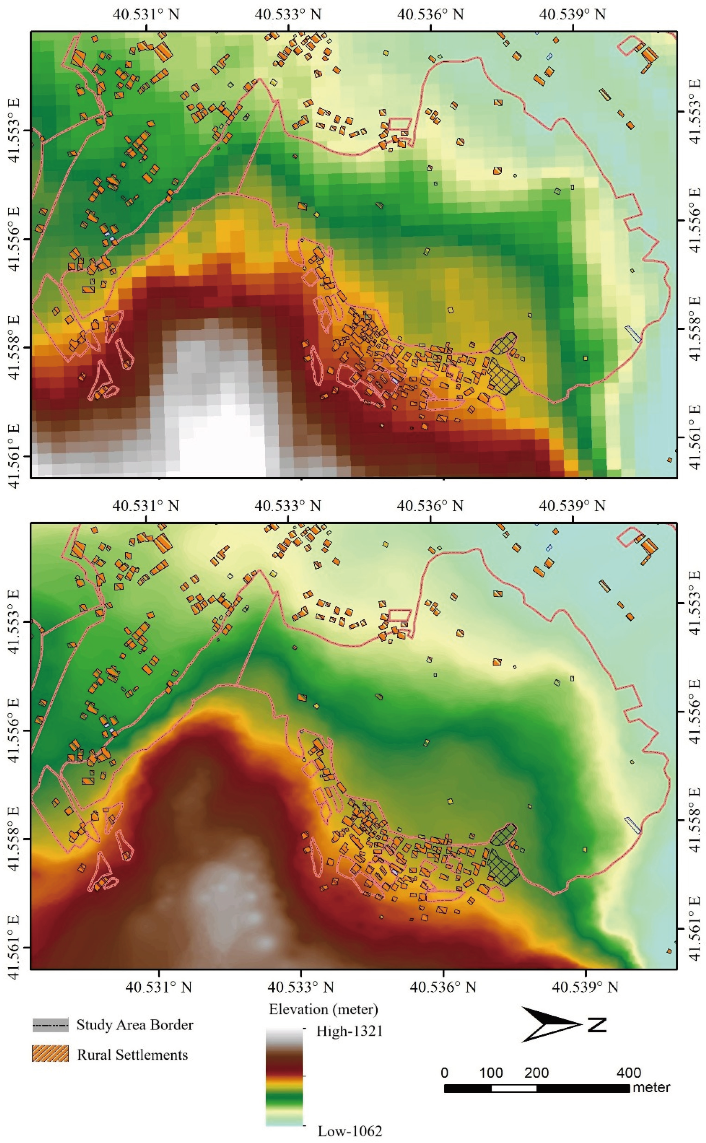
2.2. Study Area and Data Acquisition

The study was conducted in Uzundere, a mountainous rural district in Erzurum Province, northeastern Türkiye, situated within the upper basin of the Çoruh Valley. This region exhibits complex topographical and geomorphological features, including steep slopes, deeply incised valleys, and highly fragmented land cover mosaics shaped by both anthropogenic and natural processes [105]. Elevations vary between 800 and 2500 m, while slope gradients often exceed 30°, making the area particularly challenging for conventional agricultural practices [106]. Historically, these constraints were mitigated by constructing stone-faced agricultural terraces that allowed for the cultivation of cereals, fruits, and vegetables on marginal lands. However, accelerated rural outmigration and demographic decline over the past two decades have led to the abandonment of many traditional terraced landscapes, resulting in visible land degradation and natural succession—especially pronounced in neighborhoods such as Erikli and Çağlayan [107]. Figure 1 illustrates the geographical context of the study area, showing administrative boundaries, elevation gradients, and characteristic terrain conditions that informed the drone-based data acquisition strategy for terrace analysis.
Uzundere has experienced significant rural outmigration and demographic decline, particularly over the past two decades, resulting in the erosion of its agricultural labor force and traditional land stewardship systems [105]. These socio-demographic transformations have directly contributed to the abandonment of terraced landscapes that once supported subsistence-level cereal, fruit, and vegetable farming [106]. Field observations and secondary data confirm that many terraces now exhibit clear indicators of neglect, such as deteriorated retaining structures, invasive vegetation encroachment, and accelerated soil erosion—all symptomatic of natural succession processes [107]. These abandoned or functionally degraded areas were critical in determining UAV survey zones, which were strategically categorized as active, partially abandoned, and fully degraded terraces. These categories formed the basis for flight planning and sampling stratification in the photogrammetric analysis. Figure 1, which consolidates both the geographical context and an oblique perspective from the Erikli neighborhood, visually captures the spatial variation in slope gradients and terrace condition patterns across the study landscape.
High-resolution spatial data for terrace classification and morphological assessment were obtained using a DJI Phantom 4 RTK drone, deployed in two field missions during May and July 2023 under optimal weather conditions—clear skies and wind speeds below 5 m/s. This UAV model is widely recognized for its centimeter-level positioning accuracy and is frequently used in topographically complex environments such as mountainous rural regions [108,109]. Equipped with a 20 MP RGB sensor, the drone flew autonomous double-grid patterns at an altitude of 75 m, generating a ground sampling distance (GSD) of approximately 2.3 cm/pixel. This flight configuration, including 80% frontal and 70% lateral overlap, aligns with best practices in UAV photogrammetry to ensure adequate tie point density and model stability in 3D reconstruction [110,111].
A total of 1370 images were captured across 72 hectares, covering three zones with different terrace density levels. Seven ground control points (GCPs) were deployed and georeferenced using a Real-Time Kinematic Global Navigation Satellite System (RTK-GNSS), following standard protocols for precision georeferencing in drone mapping campaigns [112]. Each GCP was marked with high-contrast checkerboard targets easily identifiable in the image set, and their integration significantly improved the absolute positional accuracy of the generated orthomosaics and digital elevation models (DEMs). This setup is especially critical in undulating terrain and for feature classification tasks, where vertical accuracy directly affects morphological interpretation [113].
To ensure full spatial compatibility with national geospatial frameworks, all datasets—including orthomosaics, point clouds, and DEMs—were projected into the Universal Transverse Mercator (UTM) coordinate system, Zone 37N (EPSG:32637). This transformation facilitates seamless integration with Türkiye’s topographic base maps and cadastral layers, enabling accurate spatial analysis and overlay operations in subsequent GIS-based workflows. The specifications of the UAV platform and mission parameters used in this study are summarized in Table 1, which are consistent with previous applications of the DJI Phantom 4 RTK in precision topographic and morphological surveys [114,115,116].

2.3. Image Processing and DEM—Orthomosaic Production

The acquired UAV imagery was processed using Agisoft Metashape Professional (v1.8.4), a widely used photogrammetric software that enables automated 3D reconstruction through Structure from Motion (SfM) and Multi-View Stereo (MVS) algorithms. This approach has become a standard for generating georeferenced spatial products in rugged or topographically complex terrains due to its capacity to handle high image overlaps and heterogeneous landscape textures [117,118,119].
The processing pipeline followed established protocols for UAV-based topographic modeling, consisting of the following sequential stages: photo alignment, sparse point cloud generation, camera optimization, dense point cloud reconstruction, digital surface model (DSM) generation, orthomosaic creation, and georeferencing with ground control points (GCPs). These steps ensure internal consistency in camera calibration and spatial accuracy in model outputs, particularly in mountainous landscapes where slope-induced distortions may otherwise reduce reconstruction quality [120,121].
An overview of this photogrammetric workflow is presented in Figure 2, which illustrates each key stage in the transformation of raw UAV imagery into georeferenced elevation and texture data products. The visual representation aligns with established SfM-MVS frameworks and demonstrates how terrace features are extracted, interpreted, and prepared for GIS-based slope and density analyses [122,123].
Initial image alignment was conducted at “high” accuracy settings within Agisoft Metashape, utilizing embedded geotags from the UAV’s onboard GNSS module. Following quality filtering procedures that excluded blurred or low-overlap frames, 1320 images were retained and aligned, producing a sparse point cloud comprising over 3.2 million tie points. This dense constellation of features allowed for precise camera calibration and project-wide geometry stabilization, critical in rugged, vegetated terrains such as the Çoruh Valley slopes [124].
The dense point cloud was generated using the “ultra high” setting in the MVS pipeline, yielding more than 75 million points. This level of spatial granularity ensures the accurate reconstruction of fine-scale terrace morphology and landscape microstructures, although additional noise filtering was required to eliminate artifacts caused by vegetation shadows and surface reflectance irregularities [125].
Ground control points (GCPs) were incorporated during the bundle adjustment phase, providing a robust external reference framework that significantly reduced geometric distortions. The resulting horizontal and vertical Root Mean Square Errors (RMSEs) were ±2.1 cm and ±2.7 cm, respectively—well within accepted thresholds for UAV-based high-resolution terrain modeling in agricultural or mountainous regions [126,127].
The digital elevation model (DEM) was interpolated from the filtered dense cloud using Agisoft’s “average” depth map algorithm, generating a raster surface with a 5 cm spatial resolution, suitable for distinguishing individual terrace risers and steps. Similarly, the orthomosaic, also derived from the dense cloud, was exported at 2.3 cm/pixel resolution in GeoTIFF format, complete with embedded geospatial metadata. These output characteristics meet or exceed the resolution thresholds required for terrace classification and slope/density analytics in drone-based geomatics workflows [128,129].
Both the digital elevation model (DEM) and orthomosaic layers were exported in EPSG:32637 projection (UTM Zone 37N), ensuring seamless spatial alignment with Türkiye’s national cadastral and land use datasets. This consistency is critical for accurate overlay analyses, vector feature extraction, and landform segmentation in GIS environments [130].
Raster datasets were imported into QGIS 3.28, where hillshading, slope raster generation, and visual QA/QC procedures were applied to evaluate the positional accuracy and topographic realism of the outputs. Raster alignment and illumination settings were calibrated to minimize shadow distortion and enhance terrace delineation on steep slopes [131].
The technical specifications of the raster products are detailed in Table 2, including file formats, spatial resolutions, projection systems, and compression methods. The high-resolution outputs—5 cm for DEM and 2.3 cm for orthophotos—allow for terrace boundary digitization, erosion feature detection, and micro-topographic analysis. These datasets form the analytical basis for all subsequent slope categorization, density indexing, and spatial pattern recognition workflows in this study [132] (Figure 3).

2.4. Spatial Analysis and Terrace Classification

The spatial analysis was conducted using QGIS 3.28 and Python 3.10 environments, integrating raster algebra, vector overlays, and zonal statistics modules for comprehensive terrain and land use evaluation. A two-stage classification process was implemented to delineate and assess agricultural terraces:
(1) The extraction of terrace candidate zones through analysis of DEM derivatives (e.g., slope, curvature) and orthophoto textures;
(2) The categorization of terrace polygons based on slope-angle and area-size thresholds adapted from regional typologies and previous UAV-based studies [33,133,134].
The methodological framework reflects best practices in UAV-supported landscape segmentation, ensuring reproducibility and comparability with similar Mediterranean and Anatolian case studies [135,136]. The combination of open-source GIS platforms and structured scripting in Python allowed for the integration of topographic metrics and vegetation indicators in a spatially explicit classification workflow [137,138].
Slope gradients were computed using the r.slope.aspect module in GRASS GIS, producing a continuous raster layer from the UAV-derived DEM. The slope raster was then reclassified into five terrain categories based on morphometric thresholds: 0–5° (flat), 5–15° (gently sloping), 15–25° (moderately sloping), 25–35° (steep), and >35° (very steep). This classification scheme was adapted from widely accepted geomorphological standards and Mediterranean agricultural slope studies [33,133,134].
Field validation through GNSS ground tracks and systematic visual interpretation confirmed that most terrace structures occur within the 15–35° slope range, corroborating previous findings in Anatolian and Mediterranean terraced environments [135,139]. Terrace polygons were delineated using a semi-automated contour-based segmentation method applied to the orthomosaic, followed by manual refinement to correct edge misclassifications and eliminate non-terraced anomalies.
In terms of spatial footprint, terrace patches were grouped into four area-based classes derived from UAV geometry and localized farming typologies:
Micro: <20 m2
Small: 20–100 m2
Medium: 100–400 m2
Large: >400 m2
The classification scheme used in this study also draws on the typological structure proposed by the ALPTER Project (Alpine Terraced Landscapes), a comprehensive transnational initiative supported by the INTERREG IIIB Alpine Space Programme. ALPTER offered a replicable model for cataloguing and assessing terraced systems based on slope gradients, terrace widths, morphological coherence, and agricultural viability [140,141]. By incorporating ALPTER-based thresholds into our slope- area classification, we ensured that the resulting typology not only reflected localized farming realities in Anatolia but also aligned with broader European standards for heritage terraced landscapes. This alignment enhances the comparative potential of our findings and supports the policy-oriented reuse of abandoned terraces, as emphasized in Mediterranean studies on landscape recovery and erosion control [141,142]. The ALPTER classification has proven particularly useful in identifying vulnerable terrace forms prone to degradation, especially in contexts where slope classes exceed 25° and where marginal land use dominates. These thresholds integrate both spatial metrics and socio-agricultural functions, enabling differentiation between subsistence household strips, mixed communal plots, and historically shared macro-parcels. A formal summary of these terrace classification attributes—based on both ALPTER standards and localized typologies—is provided in Table 3, supporting replicability and regional comparison across terraced landscapes. Similar classification schemes have been used in Mediterranean and Anatolian contexts, where parcel morphology reflects both topographic constraints and agronomic intensity [141,142]. Moreover, abandoned or marginal terraces often correspond to micro- and small-size classes, revealing spatial patterns of land degradation and socio-economic transition [143,144].
To assess the intensity and continuity of terrace use, a Terrace Density Index (TDI) was calculated as the ratio of the total terrace area to the total land area within each 1-hectare raster cell. This index enabled the quantification of spatial clustering in terrace distribution, revealing localized hotspots of terrace retention and degradation. TDI values were visualized using graduated symbology in QGIS 3.28, following standard choropleth mapping practices for spatial density representation [142,144]. The results indicated strong clustering patterns, particularly in semi-active transitional zones, where land use appears to fluctuate seasonally or structurally. Figure 4 presents the slope—area-classified terrace zones, highlighting areas of high-density conservation and severely degraded landforms. These maps offer a geospatial basis for evaluating the functional resilience of terraced landscapes [145].
Additionally, a Functional Status Index (FSI) was assigned to each terrace polygon based on systematic field observations, vegetation indicators, and structural conditions. The FSI classification included three distinct categories:
Active: Cropped, maintained, or recently used parcels;
Partially Abandoned: Vegetated plots with intact walls but no clear agronomic activity;
Fully Degraded: Collapsed, fragmented, or indistinct terraces with signs of erosion and loss of boundary integrity.
These status categories were later cross-referenced with spatial clusters generated by Density-Based Spatial Clustering of Applications with Noise (DBSCAN) to evaluate the spatial correlation between terrace function and geomorphological location. The integration of field-based observations and cluster analytics enhanced the functional interpretation of terrace degradation patterns [146].
All spatial datasets were resampled and standardized to a 1 m2 grid resolution, ensuring consistency across layers and statistical comparability in zonal analysis operations. This level of granularity was essential for aligning terrace boundaries with slope gradients, vegetation indices, and soil units.

2.5. Cluster Analysis and Spatial Distribution Patterns

To assess spatial organization and fragmentation of terraced landscapes, a Density-Based Spatial Clustering of Applications with Noise (DBSCAN) algorithm was applied to the classified terrace polygons using Scikit-learn v1.3 in a Jupyter Notebook environment. DBSCAN was selected due to its ability to detect arbitrarily shaped clusters without requiring prior specification of the number of groups, and its robustness to spatial noise—an essential advantage for analyzing terrace systems that are often fragmented or degraded due to partial abandonment and heterogeneous land management practices [147,148]. The DBSCAN algorithm was originally introduced by Ester et al. [94], who defined clusters based on density-reachability and connectivity rather than geometric assumptions. Their method remains a foundational reference for unsupervised geospatial analysis due to its effectiveness in detecting clusters with arbitrary shapes and distinguishing noise in large datasets. Compared to k-means or hierarchical clustering, DBSCAN is particularly well-suited for geospatial datasets characterized by varying densities and irregular spatial configurations [146,149].
Compared to k-means clustering—which assumes isotropic data distributions and requires the number of clusters to be predefined—DBSCAN is non-parametric and well-suited to detecting clusters of irregular shape, a common characteristic of fragmented terraces in mountainous regions. Hierarchical clustering methods, although useful in structured datasets, are often sensitive to noise and overestimate group separability in heterogeneous terrains. Given the highly variable spatial density and morphological irregularity of terraced landscapes in Uzundere, DBSCAN offers greater interpretive value and robustness for unsupervised geospatial classification [150,151].
The positional accuracy of the UAV-derived outputs was assessed through seven ground control points (GCPs) and five independent Check Points (CPs) evenly distributed across the study area. Root Mean Square Error (RMSE) values were calculated as 0.18 m for horizontal accuracy and 0.29 m for vertical accuracy, which align with international standards for UAV-based photogrammetry in mountainous terrains [152,153]. These accuracy metrics ensured reliable delineation of terrace edges and slope boundaries, supporting the spatial robustness of subsequent clustering analysis. Additionally, quality checks using orthomosaic reprojection residuals and dense point cloud coherence further validated the spatial integrity of the model.
The input dataset consisted of the centroid coordinates of terrace polygons (derived from Section 2.4), each tagged with its corresponding Functional Status Index (FSI). Two core parameters were empirically defined for DBSCAN:
✓ ε (epsilon): the maximum neighborhood radius within which points are considered part of a cluster;
✓ minPts: the minimum number of neighboring points required to form a core point.
Optimal values were determined through iterative testing and silhouette coefficient evaluation (SC ≥ 0.61), ensuring a balance between cluster cohesion and noise tolerance. The selected values—ε = 35 m and minPts = 5—proved effective in capturing local-scale terrace agglomerations while filtering out spatial outliers. This parameter configuration is consistent with prior studies employing DBSCAN in mountainous or agricultural landscapes with spatial discontinuities [150,151].
A summary of the final clustering settings and associated spatial statistics is provided in Table 4, which includes the number of terraces, average TDI and FSI scores, and dominant slope class per cluster.
The DBSCAN clustering analysis revealed 11 dominant terrace clusters, predominantly situated on south-facing slopes and within the mid-elevation range of 1000–1400 m. These clusters exhibited distinct spatial patterns when analyzed in conjunction with the Terrace Density Index (TDI) and Functional Status Index (FSI) classifications. Notably, clusters with high TDI values and a greater proportion of “Active” or “Partially Abandoned” terraces tended to form tight, spatially continuous agglomerations, suggesting ongoing or residual agricultural function. In contrast, terraces classified as “Fully Degraded” were often detected as DBSCAN outliers. These isolated features were predominantly located along forest fringes, ecotonal transitions, or the periphery of abandoned village areas, indicative of socio-environmental fragmentation and land use disconnection [152,153]. The overall spatial arrangement of clusters and outliers is visualized in Figure 5, which overlays the DBSCAN results with terrain and slope gradient layers to enhance geospatial interpretation.
Cluster-based insights help to identify zones of conservation potential, particularly where partially abandoned terraces form coherent spatial groups that may benefit from targeted agro-environmental restoration efforts. Such areas are often structurally stable but functionally degraded, offering a high return on investment for land rehabilitation interventions. The identified cluster boundaries also inform spatial prioritization for local land use planning, helping authorities to enhance ecological connectivity, reduce slope instability, and prevent further land abandonment in vulnerable hillside regions [149,154].
To validate the robustness of the clustering results, global Moran’s I—a commonly used spatial autocorrelation index—was calculated based on terrace centroid distribution and FSI scores. The index yielded a statistically significant value (I = 0.41, p < 0.001), confirming the non-random spatial organization of terrace systems and justifying the application of density-based clustering for pattern recognition [155]. The integration of unsupervised clustering and spatial autocorrelation thus provides a data-driven framework to guide zoning policies, monitor landscape fragmentation, and support sustainable management of traditional terrace infrastructures in mountainous rural environments [156].
Despite the methodological rigor, certain limitations must be acknowledged. The UAV-based data collection was conducted in early summer (June 2023), which may not fully represent seasonal variations in vegetation cover, terrace visibility, and functional land use. Dense canopy or seasonal cropping may obscure some terrace boundaries or affect the accuracy of Functional Status Index (FSI) estimation. Additionally, the photogrammetric outputs—though validated with GCPs—are still subject to minor distortion due to wind conditions and lighting variability during flight operations. Future research should incorporate multi-temporal UAV surveys across different seasons to capture dynamic changes in terrace usage, vegetation dynamics, and erosion patterns. This would enhance the temporal robustness of spatial assessments and support long-term monitoring of degradation and restoration trajectories [157,158].

3. Results

3.1. Spatial Patterns and Distribution

The spatial analysis of the Uzundere study area revealed significant variations in both the distribution and functional condition of terraced landscapes. Based on the Terrace Density Index (TDI), which quantifies the ratio of terrace area to total land area per 1-hectare grid, high-density zones (>60%) were primarily observed on mid-slope, south-facing hillsides between 1000 and 1400 m in elevation. Conversely, peripheral zones and north-facing slopes exhibited much lower TDI values (<20%), as shown in Figure 4.
Slope analysis, derived from the high-resolution DEM, indicated that most terraces were concentrated within the 15–30° slope class, aligning with historical norms of terrace construction. Terraces on slopes exceeding 35° were fewer and frequently showed signs of degradation, such as wall collapse, soil loss, or vegetation overgrowth. These patterns were consistent across all three zones mapped in the UAV orthomosaic (Figure 3) and are summarized in Table 3.
Terrace parcels were classified by size into four categories: micro (<20 m2), small (20–100 m2), medium (100–400 m2), and large (>400 m2). The majority of terraces (58%) fell into the small and medium size classes, often clustered around older village cores or along traditional irrigation paths.
The Functional Status Index (FSI), assigned through field verification and vegetation analysis, categorized terraces as active, partially abandoned, or fully degraded. Active terraces made up approximately 42% of total coverage, primarily within high-density zones. Fully degraded terraces accounted for 21%, mostly located near the outer edges of the valley or on extremely steep terrain.
Application of the DBSCAN algorithm yielded 11 distinct terrace clusters, with parameters ε = 35 m and minPts = 5. Most clusters were spatially compact, forming around dense networks of active or partially abandoned terraces. Spatial analysis of these clusters, conducted in relation to elevation contours and slope classes, revealed that isolated and degraded terraces were frequently flagged as outliers or noise points, particularly along forest boundaries and on plots previously used for agriculture but now abandoned. This distribution pattern underscores the relationship between landscape fragmentation and functional degradation, providing insight into the spatial determinants of terrace resilience.
Further spatial overlay showed that areas with a high TDI did not always align with high FSI scores. For instance, Cluster 6 had a TDI of 58% but included 47% partially abandoned terraces, indicating morphological presence without consistent functionality. Table 4 summarizes the clustering metrics and spatial statistics for each group.
In total, the integrated spatial indicators—TDI, slope, area, FSI, and cluster outputs—provided a comprehensive understanding of how terrace systems are distributed, degraded, and spatially organized within the study area.

3.2. Functional Degradation Patterns of Terraced Landscapes

The analysis of functional degradation within the terraced landscapes of Uzundere revealed three distinct categories of terrace condition based on the Functional Status Index (FSI): Active, Partially Abandoned, and Fully Degraded. This classification, derived from UAV imagery, vegetation density, and field validation, was instrumental in understanding the ongoing transformations in the landscape’s use and integrity.
Across the 72-hectare study area, approximately 42% of terraces were classified as Active, indicating visible signs of cultivation or regular maintenance. These terraces exhibited sharp edge definition in the orthomosaic imagery, minimal vegetative overgrowth, and signs of recent land use such as tilled soil or managed tree rows. Most active terraces were located within dense clusters mapped by DBSCAN and situated on slopes between 15–30°, with medium-sized (100–400 m2) terrace patches being predominant.
Partially Abandoned terraces constituted approximately 37% of the total. These areas displayed semi-structured outlines with low-to-moderate vegetative encroachment. Though the stone walls remained largely intact, there was no visible sign of recent cropping. In many cases, spontaneous grasses and shrubs were observed, and slope analysis indicated that these terraces were slightly steeper (25–35°) and more fragmented than the active ones. These parcels often bordered degraded zones or forest margins.
The remaining 21% of terraces were categorized as Fully Degraded, lacking discernible boundaries or showing evidence of structural collapse. These areas were marked by vegetation succession, landslide scars, or gully erosion, indicating both abandonment and ecological transformation. Most degraded terraces were located in the outer zones of the valley and on steeper slopes (>35°), especially above 1400 m elevation or near uncultivated lands.
The spatial distribution of degradation types showed a clear concentric pattern. Active terraces formed compact inner clusters near the valley center and main settlement corridors, while partially abandoned and degraded terraces expanded outward. Figure 5 illustrates the overlay of DBSCAN clusters with FSI categories, showing that degraded terraces were typically found in fragmented or isolated outlier positions rather than within cohesive clusters.
Additionally, overlay analysis between TDI and FSI revealed non-linear correlations. For example, areas with high terrace density (TDI > 50%) sometimes contained more than 50% abandoned or degraded units, suggesting that morphological presence does not ensure functional vitality. Cluster 4 was a notable case: despite high structural integrity, 63% of its terraces were classified as functionally abandoned.
Land parcel size and slope emerged as critical drivers. Micro and small terraces on steep slopes had the highest likelihood of degradation, while medium-sized units on moderately sloped terrain were most likely to remain active. Terraces closer to access paths, irrigation lines, or village centers also showed higher functional retention, confirming the role of infrastructural proximity.
Overall, the combination of UAV-based morphological indicators and FSI classification enabled the identification of not only where degradation occurs but also how it spatially evolves within terraced systems. This provides an essential baseline for future intervention targeting and long-term monitoring.

3.3. Cluster Structures and Landscape Cohesion

The spatial clustering of terraces using the DBSCAN algorithm revealed distinct patterns of landscape cohesion and fragmentation across the study area. With ε set to 35 m and minPts to 5, the clustering process yielded 11 valid clusters and a group of non-clustered noise points. These clusters varied in terms of size, elevation, slope profile, and functional terrace composition.
Clusters 1, 2, and 3, located in the central valley floor and lower mid-slope regions (elevation 1000–1250 m), were the largest and most cohesive groups. They each contained over 40 terrace parcels, the majority of which (above 60%) were functionally active. These clusters also corresponded with zones of high TDI (>50%) and moderate slope (15–25°), indicating strong spatial coherence in both morphological and functional dimensions.
Cluster 4, although structurally dense (TDI = 58%), exhibited significant internal variability: 63% of its terraces were partially abandoned. This suggests that despite morphological integrity, social or economic factors may be driving a transition toward degradation. Similar trends were found in Cluster 7, located at slightly higher elevations (1300–1450 m) and steeper slopes, where the density remained high but more than half of the terraces were functionally inactive.
Smaller clusters (Clusters 8 to 11) typically consisted of 8–15 terrace parcels, often situated on steep hillsides or peripheral areas. These clusters exhibited higher internal heterogeneity, both in slope and FSI. In particular, Cluster 10, although fully formed morphologically, had the highest percentage of fully degraded terraces (78%), reflecting both structural fragility and functional abandonment.
In contrast, outlier terraces—those not included in any cluster—displayed markedly different characteristics. Located mostly near forest boundaries, ridgelines, or marginal grazing zones, these terraces had irregular geometries, were spatially isolated, and were often functionally degraded. These patterns are visualized in Figure 5, where noise points are seen in light gray outside the cluster boundaries.
Analysis of intra-cluster FSI distribution revealed that the most resilient clusters shared three features:
(1) Proximity to settlements or road networks;
(2) Moderate elevation and slope;
(3) Internally consistent terrace sizes (mostly medium-sized).
Conversely, the most vulnerable clusters were those located at ecological edges, with internal variation in terrace typology and slope exposure. The standard deviation of slope within clusters was a key indicator: clusters with >10° slope variation had higher abandonment rates.
Spatial overlay between cluster boundaries and infrastructure layers (irrigation lines, trails) further confirmed the importance of physical connectivity for terrace maintenance. Clusters intersecting with legacy irrigation paths maintained higher active FSI scores (avg. 54%) compared to those lacking such connections (avg. 29%).
The cohesion or fragmentation of terrace clusters thus appears to be governed by a combination of topographic constraints, accessibility, and functional continuity. Mapping and quantifying these patterns provide a critical tool for identifying zones of resilience and fragility within the terraced landscape, setting the stage for targeted conservation and restoration planning.

4. Discussion

4.1. Interpreting Spatial Distribution in Global Context

The spatial configuration of terraced landscapes in Uzundere reflects consistent global patterns observed across various mountainous regions where agroecological heritage plays a critical role in land management. The tendency of terraces to concentrate on moderate slopes (15–30°), at mid-elevation ranges (1000–1400 m), and on south-facing aspects aligns with historical terrace distribution documented in Southern Europe [30], southwestern China [156,159], and northern Ethiopia [34]. These alignments suggest a convergence in ecological logic behind terrace siting, which combines soil retention, solar exposure, and irrigation feasibility [157].
Zhang et al. observed similar slope-related distribution in central China, where mid-slope terraces showed the highest structural and functional resilience due to favorable microclimates and access to irrigation [35]. In Spain, Murray et al. identified long-term stability in terraces located near ancient irrigation systems, showing how landscape memory reinforces spatial persistence [36]. Comparable dynamics were also noted in Andean regions, where ancient hydraulic systems coincide with enduring terrace productivity [158]. The landscape-memory framework increasingly guides European policy debates on terrace conservation [160].
In Uzundere, although high Terrace Density Index (TDI) values were mapped in several zones, many of these clusters exhibited high proportions of partially or fully abandoned terraces, indicating a disconnect between morphological density and functional vitality. This morphological-functional disjunction is increasingly recognized in the global terrace literature. In particular, the term “ghost terraces” is used in Japanese and Mediterranean studies to describe terrace structures that remain physically intact but have lost their productive function due to long-term neglect, abandonment, or socio-economic transformation [42]. These terraces often retain their geometric footprint and wall infrastructure but are no longer cultivated, maintained, or integrated into active land management systems. In Latin American contexts, a similar phenomenon is described as “remnant cultural infrastructure”, highlighting their symbolic and historical presence without ongoing utilitarian value [37]. Parallel observations have been reported in Nepalese and Moroccan terraced regions, where the visible structural continuity masks a loss of traditional maintenance, labor input, and agro-ecological function [38]. Recent comparative syntheses link this phenomenon to tenure fragmentation, demographic decline, and the erosion of communal governance traditions—factors that collectively undermine the functional resilience of terraced systems [61,70].
This spatial mismatch is echoed in García-Ruiz et al.’s comparative work across terraced zones in Morocco, Nepal, and Mexico, where terrace structure persisted despite socio-economic collapse [38]. Similarly, Xue et al. argue in their global meta-synthesis that landscape fragmentation due to land tenure division and youth migration can lead to high-density but low-use landscapes [39]. In the context of East Africa and Southeast Asia, recent studies have further confirmed that traditional infrastructure may remain visible in satellite imagery yet be functionally obsolete due to labor shifts and market reorientation [160].
The concentric retreat of active terraces from core zones toward marginal peripheries matches the pattern described by Brandt and Geeson [40] and Kangalawe [161], who frame terrace abandonment as a spatially progressive process driven by declining labor availability, economic marginality, and loss of institutional support. Comparative longitudinal studies in the Balkans and Caucasus also suggest similar transitions, where abandonment follows a core-to-edge sequence linked to accessibility and demographic shifts [142]. This peripheralization process has also been observed in mountainous Taiwan and southern Italy, where outlying terrace systems collapse first due to infrastructural disconnection and land use inflexibility [162].
In Uzundere, medium-sized terrace parcels situated in spatially cohesive clusters were more resilient, while isolated or micro-parcels showed more rapid degradation. This confirms Zoumides et al.’s findings that spatial cohesion at the landscape level supports both ecosystem service delivery and socio-cultural landscape identity [42]. Additional research by Gibling also emphasizes the link between terrace resilience and geomorphological suitability, noting that compact clusters on moderate slopes are less prone to soil instability and erosion [163].
Policy-relevant parallels exist with restoration success stories in the European Alps, where terraced landscapes within well-defined clusters—particularly those close to legacy infrastructure and settlements—demonstrate greater rehabilitation potential [164]. Similar results are reported in Bhutan and the Andes, where proximity to roads, collective action, and supportive policy frameworks slowed spatial disconnection and facilitated terrace reuse [165]. Recent studies from Portugal and Peru highlight that participatory governance and community-led monitoring also enhance the durability of such restorations by aligning traditional knowledge with spatial planning tools [162].
The Uzundere results reinforce the notion that spatial configuration is both an indicator and a determinant of terrace vitality. Patterns of clustering, slope suitability, and functional coherence are pivotal in identifying intervention zones and predicting degradation risk. Studies from the Pyrenees and Andean ranges similarly stress the role of spatial proximity and internal homogeneity in sustaining terrace systems [53,61,142]. Recent spatial diagnostics utilizing landscape metrics and clustering algorithms (e.g., [16], TDI, FSI, DBSCAN) have been increasingly used to guide territorial planning and restoration zoning, especially when combined with socio-economic indicators and historical land tenure data [147,148,151]. Such integrated methods offer replicable models for spatially targeted agro-environmental policies [166].
In sum, Uzundere’s terraced landscape is not an isolated anomaly but rather a compelling case of globally convergent dynamics. Its spatial logic—defined by biophysical feasibility, infrastructural legacies, and socio-political transitions—mirrors broader patterns seen in marginal mountainous landscapes from Southeast Asia to the Mediterranean [53,164]. As emphasized in global syntheses, the evolution of terrace vitality is shaped by feedback loops between environmental constraints, land management traditions, and external pressures like rural depopulation or market integration. This confirms the theoretical proposition that landscape structure functions not only as an ecological framework but also as a socio-cultural archive [80].
Future research directions may include longitudinal tracking of terrace change using UAVs and AI-based object recognition, multi-scalar socio-economic modeling of abandonment drivers, and participatory mapping of terrace value perception among local stakeholders [81,92]. Cross-case comparative studies would also enrich the understanding of resilience pathways and support the formulation of transregional landscape governance strategies.

4.2. Socio-Environmental Drivers of Functional Degradation

The degradation of terraced landscapes in Uzundere is not solely a biophysical process but rather the outcome of a complex interplay between environmental constraints and evolving socio-economic dynamics [51,61]. Across the study area, terraced parcels that exhibited full or partial functional abandonment were overwhelmingly associated with steep slopes, reduced accessibility, and socio-demographic disconnection [41]. These observations are consistent with research across other mountainous regions, where land abandonment is strongly influenced by shifting labor patterns, tenure insecurity, and declining economic viability [11,161]. Recent studies in the Himalayan foothills and the Carpathian region confirm that abandonment hotspots often emerge where marginal terrain coincides with demographic fragility and institutional withdrawal [70]. Furthermore, rural resilience assessments suggest that landscape vulnerability increases significantly when environmental exposure is compounded by socio-economic marginality. In the context of agroecological systems, such as terraced landscapes, this dual exposure exacerbates degradation risks and undermines adaptive capacity [164].
A primary socio-environmental driver in Uzundere appears to be rural depopulation, which has led to the breakdown of generational knowledge transfer and a decline in agricultural labor. Similar findings have been reported by Grau and Aide in Latin America, where emigration from rural regions has resulted in widespread terrace neglect [60]. Adamsone-Fiskovica and Grivins [167] similarly documented the loss of agro-technical skills and stewardship traditions in Spain due to demographic aging and migration. Recent research from northern Italy and the western Balkans links youth outmigration with increasing land use discontinuity and weakened community-based management systems [139,168]. The loss of traditional agro-technical skills, coupled with a shrinking labor force, reduces the feasibility of maintaining labor-intensive infrastructures like terraces. This phenomenon has also been observed in Peru and western China, where demographic transitions have led to the disintegration of communal land management institutions [39,165]. As younger generations pursue education and employment in urban centers, the continuity of traditional land practices is interrupted, rendering terraces particularly susceptible to abandonment and ecological transformation.
Land tenure fragmentation is another critical factor. In Uzundere, parcels less than 50 m2—often inherited through successive divisions—exhibited a high correlation with degradation. Brandt and Geeson’s meta-analysis confirmed that fragmented ownership structures reduce the capacity for coordinated land use, particularly in systems requiring collective action like terrace maintenance [40]. Yang et al. further emphasize that social capital, rather than ownership alone, determines the longevity of terraced landscapes [46]. Similar conclusions have been drawn in studies from the Andes and Balkan regions, where land atomization significantly undermined agricultural sustainability and landscape integrity [58,169].
Environmental constraints further exacerbate degradation. Terraces located on slopes steeper than 35°, on north-facing aspects, or beyond 1 km from main access roads were consistently more likely to be classified as degraded. These terrain conditions increase maintenance costs and reduce mechanization potential—a trend also observed in Bhutan and Nepal. Dax et al. found that marginal physical conditions, when combined with socio-political neglect, are decisive in abandonment outcomes [50]. Recent geospatial studies in eastern Anatolia and the Atlas Mountains reinforce these findings, emphasizing the cumulative impacts of elevation, aspect, and remoteness on functional decline [94,138].
Functional degradation is also linked to policy and institutional gaps. Interviews with local stakeholders in Uzundere indicate that state subsidies for sustainable agriculture are often either inaccessible or poorly targeted, particularly in peripheral communities. This echoes findings by Blaikie and Muldavin in the Andes and Chaudhary et al. in the Himalayas, where policy failure to differentiate between terrace systems and conventional farming undermines conservation efforts [51,52]. Comparable challenges have been reported in Turkey’s eastern Black Sea region, where policy instruments often neglect traditional agroecological infrastructures such as terraces [77]. Additionally, case studies from northern India and Peru highlight that national rural development programs frequently lack spatial sensitivity, leading to unequal distribution of conservation resources [165,170]. These policy mismatches reduce the adaptive capacity of local land users and delay restoration efforts in degraded terraces.
In contrast, community-based governance has shown potential to mitigate degradation. In Greece, Golfinopoulos and Koumparou demonstrated that collaborative terrace management sustained by informal village institutions preserved terraced systems despite demographic decline [46]. Similar models in Japan and Italy have shown success when local actors are empowered to co-manage infrastructure, land use, and restoration planning [168,171]. Comparable community-driven initiatives in Portugal and the Philippines also highlight that decentralized decision-making and participatory planning mechanisms enhance the socio-ecological resilience of terraced landscapes [172,173]. Where external technical support is aligned with local organizational structures, long-term sustainability of terraces becomes more feasible and cost-effective.
A final but increasingly relevant factor is climate variability. In Uzundere, interviews and UAV-based visual assessments suggest that rainfall irregularity and prolonged drought events are beginning to accelerate the degradation of structurally intact but functionally fragile terraces. Tarolli et al. and Bocco and Napoletano both highlight how climate extremes erode the viability of marginal farming systems, leading to cascading degradation of terraces [174,175]. In Mediterranean and Himalayan contexts, climate-driven stressors such as erratic precipitation, reduced snowmelt, and soil moisture decline have compounded the vulnerability of traditional agroecosystems. Moreover, studies from Iran and northern Pakistan reveal that extreme weather anomalies not only damage physical structures but also disrupt planting calendars and intergenerational farming knowledge transfer [176,177]. This indicates that climate variability acts as both a direct and indirect driver of terrace system destabilization.
In conclusion, the degradation of terraces in Uzundere cannot be reduced to physical erosion alone. It is the cumulative expression of structural inequalities, demographic trends, governance voids, and ecological risk. These interlinked pressures create feedback loops that undermine long-term resilience unless comprehensively addressed. Therefore, any conservation or revitalization strategy must be embedded in socio-environmental diagnostics that integrate climate vulnerability assessments, tenure systems, economic incentives, and local governance frameworks. This integrated approach has been endorsed in recent sustainability frameworks emphasizing place-based, participatory, and climate-adaptive management of mountain landscapes [178,179].

4.3. Landscape Cohesion and Planning Implications

The spatial clustering analysis conducted through DBSCAN revealed strong correlations between landscape cohesion and terrace vitality in Uzundere. Clusters with a high degree of internal homogeneity—characterized by similar slope classes, contiguous parcels, and medium terrace size—demonstrated higher levels of functional integrity. These cohesive systems, often found near roads and settlement cores, maintained greater resilience against abandonment pressures.
In contrast, fragmented clusters, or those located at the periphery with significant elevation or slope variability, showed disproportionately higher rates of partial or complete degradation. This aligns with findings from the Swiss Alps and southern Italy, where terrace fragmentation was both a cause and consequence of land use decline. Fragmented structures are not only harder to manage but also more expensive to rehabilitate, especially where infrastructure is lacking.
The concept of landscape cohesion extends beyond physical continuity. Plieninger and Bieling [5] argue that cohesive landscapes foster stronger cultural identity, social memory, and environmental stewardship, which, in turn, reinforce land management practices. In Uzundere, stakeholders in more cohesive zones were more aware of past restoration projects and more engaged in community-based land use, suggesting that social cohesion mirrors spatial cohesion.
Table 4, which compares cluster structure and functional composition, highlights that clusters with ≤15% slope variance retained higher FSI scores, supporting Arnáez et al.’s claim [59] that internal topographic consistency is key for terrace stability. Moreover, these clusters had greater proximity to legacy irrigation lines and village centers, a factor Alhajj et al. associate with lower maintenance thresholds and better reactivation prospects [43]. Recent work by Burel and Baudry [180] further supports the notion that spatial structure is deeply interlinked with landscape functioning, particularly in anthropogenic systems such as agricultural terraces.
The planning implications of these findings are substantial. First, not all terrace zones require equal investment. Spatial analytics can be used to prioritize cohesive but degraded clusters for targeted interventions. Such selective restoration has been applied successfully in parts of Greece and Portugal [181,182], where EU-funded agri-environmental schemes focused on semi-intact clusters produced measurable gains in functionality and heritage value.
Second, integrating cohesion metrics into rural development planning can help prevent further fragmentation. As van Noordwijk et al. suggest [183], territorial policies that recognize traditional cluster patterns can serve as a scaffold for adaptive land use and landscape multifunctionality. More recent assessments also emphasize the importance of coupling these policies with participatory spatial planning tools to enhance their long-term effectiveness, particularly in mountainous agricultural landscapes.
Third, cross-sector coordination is essential. Terrace cohesion is undermined when agricultural, forestry, and conservation policies operate in silos. Migliorini et al. argue [184] that integrated governance—through landscape observatories and inter-municipal land use councils—has enhanced resilience in Mediterranean regions. Recent evaluations also show that cross-sectoral planning platforms facilitate shared responsibility and increase policy uptake in rural multifunctional landscapes.
Finally, cohesion offers a framework for combining spatial diagnostics with social action. In Uzundere, village-led efforts to restore terraced slopes around shared irrigation sources reveal that cohesion-driven strategies are not only technically efficient but also socially acceptable. Similar findings from the Italian Apennines and Japanese Satoyama landscapes show that when physical proximity is matched by communal stewardship, restoration efforts become more sustainable [185,186].
In sum, spatial cohesion should be considered a strategic variable—not a passive outcome—in planning the future of terraced systems. It enables planners to move from reactive preservation to proactive, spatially-sensitive governance that aligns ecological logic with cultural continuity.
In addition to spatial diagnostics based on clustering and slope metrics, future landscape planning efforts may benefit from the integration of Building Information Modeling (BIM) and Geographic Information Systems (GIS). While BIM has traditionally been applied to urban and structural environments, its convergence with GIS has opened new possibilities for 3D modeling, spatial scenario simulation, and multi-scale heritage planning in rural and semi-natural landscapes. For terraced systems such as those in Uzundere, this integration could facilitate precise topographic reconstruction, enhance maintenance forecasting, and improve decision support mechanisms for restoration interventions. Recent interdisciplinary studies demonstrate the viability of BIM-GIS approaches in forestry and land use contexts across Europe [187,188], suggesting their adaptability to complex, multi-layered rural environments as well.

5. Conclusions

This study presents an integrated spatial–functional assessment of agricultural terraces in the Erikli neighborhood of Uzundere, a Cittaslow-designated rural landscape in northeastern Türkiye. By combining drone-based photogrammetry, terrain modeling, GIS analytics, and the DBSCAN clustering algorithm, the research generated high-resolution insights into terrace morphology, density, and functional status across complex mountainous terrain. Unlike traditional surveys or coarse-resolution land use data, this approach offers a replicable, fine-scaled model for diagnosing terrace landscapes with spatial precision. The methodological framework not only fills a gap in remote sensing applications for cultural landscape analysis but also contributes to a growing body of interdisciplinary research that seeks to operationalize spatial diagnostics supported by UAV-based data acquisition for planning, resilience, and heritage conservation.
The results reveal a fundamental dichotomy in Uzundere’s terraced landscape: although many mid-slope, south-facing clusters retain robust morphological continuity, their functional vitality is increasingly compromised. Approximately 58% of all mapped terraces exhibit signs of partial or full degradation, a pattern especially concentrated in fragmented or peripheral zones characterized by steep slopes, limited road access, and disconnection from traditional irrigation networks. In contrast, terrace clusters located near settlement cores, where slope variability is low and access to legacy infrastructure is high, demonstrate greater functional resilience and ongoing agricultural activity. These spatial–functional disparities confirm the hypothesis that morphological persistence does not necessarily equate to active land use, a phenomenon similarly reported in terraced systems across Southern Europe and East Asia.
The integrated application of the Terrace Density Index (TDI) and Functional Status Index (FSI) enabled the precise identification of high-risk zones, which, despite morphological integrity, exhibit clear signs of functional abandonment. This analytical distinction is critical, as it uncovers latent vulnerabilities often masked by structural continuity. Spatial clustering using DBSCAN further revealed statistically significant associations between terrace degradation and landscape fragmentation, elevation gradients, and slope variance. Together, these spatial metrics do not merely map the distribution of terraces—they elucidate the underlying spatial logic that governs either their resilience or collapse. Such metrics offer not only diagnostic value but also strategic insight for prioritizing restoration zones and tailoring agro-environmental interventions to site-specific conditions.
Beyond its empirical contributions, this study underscores broader socio-environmental and policy implications that are vital for the resilience of terraced systems. In Uzundere, functional degradation is not solely the outcome of biophysical constraints but is deeply rooted in complex socio-political dynamics. Key drivers include land tenure fragmentation, sustained rural depopulation, the erosion of intergenerational agricultural knowledge, and the absence of adaptive or place-specific governance mechanisms. These intertwined pressures have led to a systemic weakening of terrace functionality, especially in areas detached from infrastructural and social support. Comparable patterns have been extensively documented in Mediterranean, Andean, and East Asian contexts, suggesting that Uzundere is emblematic of broader global transitions in marginal rural landscapes. Recognizing these convergences is essential for designing context-sensitive policy frameworks and transregional restoration strategies.
In conclusion, this research demonstrates the analytical and applied value of integrating remote sensing, spatial diagnostics, and functional classification in understanding and managing cultural landscapes. The synergy of high-resolution UAV photogrammetry, GIS-based metrics (TDI, FSI), and clustering algorithms (e.g., DBSCAN) enabled a nuanced evaluation of terrace conditions beyond superficial morphological assessments. These methods and insights are not only applicable to Uzundere but also offer a scalable and transferable model for other mountainous, heritage-rich regions experiencing similar degradation pressures. Global landscape governance frameworks increasingly call for such integrated, spatially explicit diagnostics to inform evidence-based interventions.
Future efforts should incorporate longitudinal monitoring using high-frequency UAV and satellite data, participatory landscape valuation with local stakeholders, and coordinated policy mechanisms across agricultural, environmental, and cultural sectors. As highlighted by emerging studies in the Himalayas and Southern Europe, only through such transdisciplinary and multi-scalar strategies can the long-term resilience, ecological functionality, and cultural continuity of terraced systems be ensured. Future research may benefit from the integration of Building Information Modeling (BIM) and Geographic Information Systems (GIS) to enhance 3D simulation, spatial diagnostics, and scenario-based restoration planning of cultural landscapes. Such interdisciplinary approaches have proven valuable in forestry and rural land use applications across Europe.

Author Contributions

Conceptualization, A.K., O.G., N.D., and F.K.; methodology, O.G., M.Ö., and F.K.; data curation, O.G., M.Ö., and F.K.; writing—original draft preparation, A.K., O.G., N.D., and F.K.; writing—review and editing, O.G., M.Ö., and F.K.; supervision, F.K. All authors have read and agreed to the published version of the manuscript.

Funding

This research received partial financial support from Atatürk University, under the Scientific Research Projects (BAP) Coordination Unit, grant number FDK–2022–10399. This funding, obtained under the coordination of Faris Karahan and with Oğuz Gökçe as project researcher, was used exclusively for a limited portion of the drone filming. All other research components, including GIS–based analysis and fieldwork, were funded by the authors themselves.

Institutional Review Board Statement

Not applicable.

Informed Consent Statement

Not applicable.

Data Availability Statement

The data presented in this study are available on request from the authors, Oğuz Gökçe and Faris Karahan.

Acknowledgments

The authors would like to express their sincere gratitude to the Uzundere District Governorship for facilitating the official permission processes regarding drone-based data collection. The authors also acknowledge the valuable support of the Uzundere Municipality in coordinating communication with elected local representatives and other relevant stakeholders. Special thanks are extended to the local farmers and residents of Uzundere for their kind cooperation and contributions during the fieldwork. The authors would also like to thank the Rectorate of Atatürk University and the Scientific Research Projects (BAP) Coordination Unit for providing financial support for this research through an institutional grant programme.

Conflicts of Interest

The authors declare no conflicts of interest.

Abbreviations

The following abbreviations are used in this manuscript:
ARAugmented Reality
DBSCANDensity-Based Spatial Clustering of Applications with Noise
DEMDigital Elevation Model
DSMDigital Surface Model
FSIFunctional Status Index
GISGeographic Information System
LiDARLight Detection and Ranging
NDVINormalized Difference Vegetation Index
RTKReal-Time Kinematic
SDGsSustainable Development Goals
SfMStructure from Motion
TDITerrace Density Index
TSITerrace Size Index
UASUnmanned Aircraft System
UAVUnmanned Aerial Vehicle

References

  1. Liniger, H.P.; Critchley, W. Where Land Is Greener: Case Studies and Analysis of Soil and Water Conservation Initiatives Worldwide; CTA/CDE/FAO/UNEP/WOCAT: Bern, Switzerland; Wageningen, The Netherlands; Rome, Italy; Nairobi, Kenya, 2007. [Google Scholar]
  2. Fuller, A.M.; Min, Q.; Jiao, W.; Bai, Y. Globally Important Agricultural Heritage Systems (GIAHS) of China: The challenge of complexity in research. Ecosyst. Health Sustain. 2015, 1, 1–10. [Google Scholar] [CrossRef]
  3. Reed, J.; Van Vianen, J.; Deakin, E.L.; Barlow, J.; Sunderland, T. Integrated landscape approaches to managing social and environmental issues in the tropics: Learning from the past to guide the future. Change Biol. 2016, 22, 2540–2554. [Google Scholar] [CrossRef]
  4. Stocking, M. Soil erosion and land degradation. In Environmental Science for Environmental Management, 2nd ed.; Chadwick, A., Ed.; Routledge: London, UK, 2000; pp. 35–56. [Google Scholar] [CrossRef]
  5. Plieninger, T.; Bieling, C. (Eds.) Resilience and the Cultural Landscape: Understanding and Managing Change in Human-Shaped Environments; Cambridge University Press: Cambridge, UK, 2012. [Google Scholar] [CrossRef]
  6. Altieri, M.A.; Toledo, V.M. The agroecological revolution in Latin America: Rescuing nature, ensuring food sovereignty and empowering peasants. J. Peasant. Stud. 2011, 38, 587–612. [Google Scholar] [CrossRef]
  7. Berkes, F.; Folk, C.; Colding, J. (Eds.) Linking Social and Ecological Systems: Management Practices and Social Mechanisms for Building Resilience; Cambridge University Press: Cambridge, UK, 2000. [Google Scholar]
  8. Mijatović, D.; Van Oudenhoven, F.; Eyzaguirre, P.; Hodgkin, T. The role of agricultural biodiversity in strengthening resilience to climate change: Towards an analytical framework. Int. J. Agric. Sustain. 2013, 11, 95–107. [Google Scholar] [CrossRef]
  9. Fisch, J.; Riechers, M.; Loos, J.; Martin-Lopez, B.; Temperton, V.M. Making the UN Decade on Ecosystem Restoration a social-ecological endeavour. Trends Ecol. Evol. 2021, 36, 20–28. [Google Scholar] [CrossRef]
  10. Pretty, J.; Bharucha, Z.P. Sustainable intensification in agricultural systems. Ann. Bot. 2014, 114, 1571–1596. [Google Scholar] [CrossRef]
  11. Lasanta, T.; Arnáez, J.; Pascual, N.; Ruiz-Flaño, P.; Errea, M.P.; Lana-Renault, N. Space-time process and drivers of land abandonment in Europe. Catena 2017, 149, 810–823. [Google Scholar] [CrossRef]
  12. García-Ruiz, J.M.; Nadal-Romero, E.; Lana-Renault, N.; Beguería, S. Erosion in Mediterranean landscapes: Changes and future challenges. Geomorphology 2013, 198, 20–36. [Google Scholar] [CrossRef]
  13. Melendez-Pastor, I.; Hernández, E.I.; Navarro-Pedreño, J.; Gómez, I. Socioeconomic factors influencing land cover changes in rural areas: The case of the Sierra de Albarracín (Spain). Appl. Geogr. 2014, 52, 34–45. [Google Scholar] [CrossRef]
  14. Koohafkan, P.; Altieri, M.A. Globally Important Agricultural Heritage Systems: A Legacy for the Future; Food and Agriculture Organization of the United Nations: Rome, Italy, 2011; pp. 1–47. [Google Scholar]
  15. Liniger, H.; Mekdaschi-Studer, R.; Hauert, C.; Gurtner, M. Sustainable Land Management in Practice: Guidelines and Best Practices for Sub-Saharan Africa; TerrAfrica, World Overview of Conservation Approaches and Technologies (WOCAT), and Food and Agriculture Organization of the United Nations (FAO): Rome, Italy, 2011. [Google Scholar]
  16. Feng, H.; Squires, V.R.; Wu, J. Ecosystem Services Provisioning, Urban Growth and the Rural-Urban Interface: A Case Study from China. Land 2021, 10, 337. [Google Scholar] [CrossRef]
  17. Glušič, A.; Štaut, L.; Zajc, L.Č. Towards Deep Learning for the Recognition of Cultivated Terraces Based on LiDAR Data: A Case Study from Slovenia. Morav. Geogr. Rep. 2024, 32, 66–78. [Google Scholar]
  18. Cohen-Shacham, E.; Walters, G.; Janzen, C.; Maginnis, S. Nature-Based Solutions to Address Global Societal Challenges; IUCN: Gland, Switzerland, 2016; Volume 97, p. 2036. [Google Scholar] [CrossRef]
  19. Nungula, E.Z.; Chappa, L.R.; Ranjan, S.; Sow, S.; Alnemari, A.M.; Seleiman, M.F.; Mwadalu, R.; Maitra, S.; Gitari, H.I. Ecosystem Services through Agroforestry Systems and Its Sustainability. In Agroforestry; Udawatta, R.P., Jose, S., Eds.; John Wiley & Sons: Hoboken, NJ, USA, 2024; pp. 223–254. [Google Scholar] [CrossRef]
  20. Altieri, M.A.; Koohafkan, P. Enduring Farms: Climate Change, Smallholders and Traditional Farming Communities; TWN: Penang, Malaysia, 2008; Volume 6, p. 72. [Google Scholar]
  21. Vrbičanová, G.; Kaisová, D.; Močko, M.; Petrovič, F.; Mederly, P. Mapping Cultural Ecosystem Services Enables Better Informed Nature Protection and Landscape Management. Sustainability 2020, 12, 2138. [Google Scholar] [CrossRef]
  22. Turn, B.L.; Sabloff, J.A. Classic Period collapse of the Central Maya Lowlands: Insights about human-environment relationships for sustainability. Proc. Natl. Acad. Sci. USA 2012, 109, 13908–13914. [Google Scholar] [CrossRef] [PubMed]
  23. Munro, R.N.; Deckers, J.; Haile, M.; Grove, A.T.; Poesen, J.; Nyssen, J. Soil landscapes, land cover change and erosion features of the Central Plateau region of Tigrai, Ethiopia: Photo-monitoring with an interval of 30 years. Catena 2008, 75, 55–64. [Google Scholar] [CrossRef]
  24. Adhikari, J.R. Integrating Indigenous, Local and Modern Knowledge for Sustainable Conservation and Management of Forest Ecosystems in Nepal; Forests of Nepal: Gateway for Information Nepal: Kathmandu, Nepal, 2015. [Google Scholar] [CrossRef]
  25. Gilmour, D.; Malla, Y.; Nurse, M. Linking Community Forestry and Poverty Reduction: A Regional Community Forestry Training Center for Asia and the Pacific, Bangkok, Thailand; Regional Community Forestry Training Center for Asia and the Pacific (RECOFTC): Bangkok, Thailand, 2007; Available online: https://www.recoftc.org/publications/0000165 (accessed on 15 April 2025).
  26. Altieri, M.A.; Nicholls, C.I.; Henao, A.; Lana, M.A. Agroecology and the design of climate change-resilient farming systems. Agron. Sustain. Dev. 2015, 35, 869–890. [Google Scholar] [CrossRef]
  27. Tarolli, P.; Straffelini, E. Agriculture in Hilly and Mountainous Landscapes: Threats, Monitoring and Sustainable Management. Geogr. Sustain. 2020, 1, 70–76. [Google Scholar] [CrossRef]
  28. Cerdà, A.; Doerr, S.H. Influence of vegetation recovery on soil hydrology and erodibility following fire: An 11-year investigation. Int. J. Wildland Fire 2005, 14, 423–437. [Google Scholar] [CrossRef]
  29. Gavin, M.C.; McCarter, J.; Berkes, F.; Mead, A.T.P.; Sterl, E.J.; Tang, R.; Turner, N.J. Effective Biodiversity Conservation Requires Dynamic, Pluralistic, Partnership-Based Approaches. Sustainability 2018, 10, 1846. [Google Scholar] [CrossRef]
  30. Wilson, G.A. Multifunctional ‘quality’ and rural community resilience. Trans. Inst. Br. Geogr. 2010, 35, 364–381. [Google Scholar] [CrossRef]
  31. Santoro, A. Why traditional rural landscapes are still important to our future. Landsc. Ecol. 2024, 39, 135. [Google Scholar] [CrossRef]
  32. Reed, M.S.A.C.; Evely, G.; Cundill, I.; Fazey, J.; Glass, A.; Laing, J.; Newig, B.; Parrish, C.; Prell, C.; Raymond, L.C.S. What is Social Learning? Ecol. Soc. 2010. Available online: https://www.ecologyandsociety.org/vol15/iss4/resp1/ (accessed on 21 April 2025). [CrossRef]
  33. Cohen-Shacham, E.; Andrade, A.; Dalton, J.; Dudley, N.; Jones, M.; Kumar, C.; Maginnis, S.; Maynard, S.; Nelson, C.R.; Renaud, F.G.; et al. Core Principles for Successfully Implementing and Upscaling Nature-Based Solutions in Environmental Management. Sci. Policy 2019, 98, 20–29. [Google Scholar] [CrossRef]
  34. Raymond, C.M.; Frantzeskaki, N.; Kabisch, N.; Berry, P.; Breil, M.; Nita, M.R.; Geneletti, D.; Calfapietra, C. A framework for assessing and implementing the co-benefits of nature-based solutions in urban areas. Environ. Sci. Policy 2017, 77, 15–24. [Google Scholar] [CrossRef]
  35. Zhang, J.C.; DeAngelis, D.L.; Zhuang, J.Y. Effectiveness of Afforestation on Soil and Water Conservation: Theory and Practice of Soil Loss Control in Eastern China. In Soil and Water Conservation in Semi-Arid Areas; Li, Z., Wang, C., Ning, D., Xu, W., Eds.; Springer: Dordrecht, The Netherlands, 2011; pp. 213–241. [Google Scholar] [CrossRef]
  36. Murray, I.; Jover-Avellà, G.; Fullana, O.; Tello, E. Biocultural Heritages in Mallorca: Explaining the Resilience of Peasant Landscapes within a Mediterranean Tourist Hotspot, 1870–2016. Sustainability 2019, 11, 1926. [Google Scholar] [CrossRef]
  37. Wu, J. Landscape sustainability science: Ecosystem services and human well-being in changing landscapes. Landsc. Ecol. 2013, 28, 999–1023. [Google Scholar] [CrossRef]
  38. García-Ruiz, J.M.; Arnáez, J.; Lasanta, T.; Nadal-Romero, E.; López-Moreno, J.I. Living in the Mountains: The Wide Variety of Land Uses and Their Geo-Ecological Consequences; Springer Nature: Cham, Switzerland, 2024; pp. 331–414. [Google Scholar]
  39. Xue, J.; Gui, D.; Zeng, F.; Yu, X.; Sun, H.; Zhang, J.; Xue, D. Assessing Landscape Fragmentation in a Desert-Oasis Region of Northwest China: Patterns, Driving Forces, Policy Implications, and Future Land Consolidation. Environ. Monit. Assess. 2022, 194, 394. [Google Scholar] [CrossRef]
  40. Brandt, J.; Geeson, N. Desertification Indicator System for Mediterranean Europe: Science, Stakeholders and Public Dissemination of Research Results. In Monitoring and Modelling Dynamic Environments: A Festschrift in Memory of Professor; Thornes, J.B., Meadows, M.E., Linés, C., Eds.; Cambridge Scholars Publishing: Newcastle upon Tyne, UK, 2015; pp. 121–137. [Google Scholar]
  41. Teshome, A.; De Graaff, J.; Ritsema, C.J.; Kassie, M. Farmers’ Perceptions about the Influence of Land Quality, Land Fragmentation and Tenure Systems on Sustainable Land Management in the North Western Ethiopian Highlands. Land Degrad. Dev. 2016, 27, 884–898. [Google Scholar] [CrossRef]
  42. Zoumides, C.; Bruggeman, A.; Djuma, H. Revitalising terraced landscapes: Co-production of ecosystem services for sustainable futures. Geogr. Sustain. 2025, 6, 100306. [Google Scholar] [CrossRef]
  43. Alhajj Ali, S.; Tallou, A.; Vivaldi, G.A.; Camposeo, S.; Ferrara, G.; Sanesi, G. Revitalization Potential of Marginal Areas for Sustainable Rural Development in the Puglia Region, Southern Italy: Part I: A Review. Agronomy 2024, 14, 431. [Google Scholar] [CrossRef]
  44. Rössler, M.; Lin, R.C.H. Cultural Landscape in World Heritage Conservation and Cultural Landscape Conservation Challenges in Asia. Built Herit. 2018, 2, 3–26. [Google Scholar] [CrossRef]
  45. Yang, L.; Liu, M.; Lun, F.; Yuan, Z.; Zhang, Y.; Min, Q. An Analysis on Crops Choice and Its Driving Factors in Agricultural Heritage Systems—A Case of Honghe Hani Rice Terraces System. Sustainability 2017, 9, 1162. [Google Scholar] [CrossRef]
  46. Yuan, Y.; Xu, G.; Shen, N.; Nie, Z.; Li, H.; Zhang, L.; Gong, Y.; He, Y.; Ma, X.; Zhang, H.; et al. Valuation of Ecosystem Services for the Sustainable Development of Hani Terraces: A Rice-Fish-Duck Integrated Farming Model. Int. J. Environ. Res. Public Health 2022, 19, 8549. [Google Scholar] [CrossRef]
  47. Liu, D.; Tang, R.; Xie, J.; Tian, J.; Shi, R.; Zhang, K. Valuation of ecosystem services of rice-fish coculture systems in Ruyuan County, China. Ecosyst. Serv. 2020, 41, 101054. [Google Scholar] [CrossRef]
  48. Hua, H.; Zhou, S. Human-Environment System Boundaries: A Case Study of the Honghe Hani Rice Terraces as a World Heritage Cultural Landscape. Sustainability 2015, 7, 10733–10755. [Google Scholar] [CrossRef]
  49. Du, X.; Yang, G.; Yuan, H.; Wu, Y.; Lv, Z.; Du, C.; Jian, J.; Wang, Q.; Huang, L.; Chen, W. Bibliometric Insights into Terracing Effects on Water Resources Under Climate Change: Advances in Remote Sensing and GIS Applications. Water 2025, 17, 1125. [Google Scholar] [CrossRef]
  50. Dax, T.; Schroll, K.; Machold, I.; Derszniak-Noirjean, M.; Schuh, B.; Gaupp-Berghausen, M. Land Abandonment in Mountain Areas of the EU: An Inevitable Side Effect of Farming Modernization and Neglected Threat to Sustainable Land Use. Land 2021, 10, 591. [Google Scholar] [CrossRef]
  51. Blaikie, P.M.; Muldavin, J.S. Upstream, Downstream, China, India: The Politics of Environment in the Himalayan Region. Ann. Assoc. Am. Geogr. 2004, 94, 520–548. [Google Scholar] [CrossRef]
  52. Chaudhary, S.; Wang, Y.; Dixit, A.M.; Khanal, N.R.; Xu, P.; Fu, B.; Yan, K.; Liu, Q.; Lu, Y.; Li, M. Spatiotemporal Degradation of Abandoned Farmland and Associated Eco-Environmental Risks in the High Mountains of the Nepalese Himalayas. Land 2019, 9, 1. [Google Scholar] [CrossRef]
  53. Gullino, P.; Larcher, F. Integrity in UNESCO World Heritage Sites. A comparative study for rural landscapes. J. Cult. Herit. 2013, 14, 389–395. [Google Scholar] [CrossRef]
  54. Garavaglia, V.; Besacier, C. Mediterranean landscape restoration: Context, global initiatives and regional dynamics. Forêt Méditeranéenne 2017, 38, 241–250. [Google Scholar]
  55. Tarolli, P.; Preti, F.; Romano, N. Terraced landscapes: From an old best practice to a potential hazard for soil degradation due to land abandonment. Anthropocene 2014, 6, 10–25. [Google Scholar] [CrossRef]
  56. Cooper, T.; Hart, K.; Baldock, D. The Provision of Public Goods Through Agriculture in the European Union; Institute for European Environmental Policy: London, UK, 2009; pp. 1–351. [Google Scholar]
  57. Murphy, B. Terracing, Land Management and Agricultural Soils in the Andagua Valley of the Southern Peruvian Andes. Master’s Thesis, University of Denver, Denver, CO, USA, 2017. [Google Scholar]
  58. Biwer, M.E. Colonialism, Cuisine, and Culture Contact: An Analysis of Provincial Foodways of the Wari Empire. Ph.D. Dissertation, University of California, Santa Barbara, CA, USA, 2019. [Google Scholar]
  59. Arnáez, J.; Lana-Renault, N.; Lasanta, T.; Ruiz-Flaño, P.; Castroviejo, J. Effects of Farming Terraces on Hydrological and Geomorphological Processes. Catena 2015, 128, 122–134. [Google Scholar] [CrossRef]
  60. Bebbington, A.; Carney, J. Geography in the International Agricultural Research Centers: Theoretical and practical concerns. Ann. Assoc. Am. Geogr. 1990, 80, 34–48. [Google Scholar] [CrossRef]
  61. Zimm, K.S. The Compatibility of Agricultural Intensification in a Global Hotspot of Smallholder Agrobiodiversity (Bolivia). Proc. Natl. Acad. Sci. USA 2013, 110, 2769–2774. [Google Scholar]
  62. Boil, S.; Berkes, F. Perception and Interpretation of Climate Change among Quechua Farmers of Bolivia: Indigenous Knowledge as a Resource for Adaptive Capacity. Ecol. Soc. 2013, 18, 21. [Google Scholar]
  63. Bertran-Vilà, M.; Pasquier Merino, A.G.; Villatoro Hernández, J.G. Food Producers in the Peri-Urban Area of Mexico City: A Study on the Linkages between Social Capital and Food Sustainability. Sustainability 2022, 14, 15960. [Google Scholar] [CrossRef]
  64. Torres-Lima, P.; Madrigal-Gómez, J. Chapter 29—Assessment of periurban dynamics and agricultural traditionality in a mega-city by using a hybrid geospatial model. A case study in Mexico City. Mod. Cartogr. Ser. 2024, 11, 663–685. [Google Scholar]
  65. Cornelius, W.; Myhre, D. The Transformation of Rural Mexico: Reforming the Ejido Sector: Center for U.S.–Mexican Studies; University of California, San Diego: La Jolla, CA, USA, 1998. [Google Scholar]
  66. Primmer, E.; Furman, E. Operationalising ecosystem service approaches for governance: Do measuring, mapping and valuing integrate sector-specific knowledge systems? Ecosyst. Serv. 2012, 1, 85–92. [Google Scholar] [CrossRef]
  67. Pascual, U.; Muradian, R.; Rodríguez, L.C.; Duraiappah, A. Exploring the Links between Equity and Efficiency in Payments for Environmental Services: A Conceptual Approach. Ecol. Econ. 2010, 69, 1237–1244. [Google Scholar] [CrossRef]
  68. Van Noordwijk, M. Agroforestry-based ecosystem services: Reconciling values of humans and nature in sustainable development. Land 2021, 10, 699. [Google Scholar] [CrossRef]
  69. Lang, D.J.; Wiek, A.; Bergmann, M.; Stauffacher, M.; Martens, P.; Moll, P.; Thomas, C.J. Transdisciplinary Research in Sustainability Science: Practice, Principles and Challenges. Sustain. Sci. 2012, 7, 25–43. [Google Scholar] [CrossRef]
  70. Tengö, M.; Hill, R.; Malmer, P.; Raymond, C.M.; Spierenburg, M.; Danielsen, F.; Elmqvist, T.; Folke, C. Weaving knowledge systems in IPBES, CBD and beyond—Lessons learned for sustainability. Curr. Opin. Environ. Sustain. 2017, 26, 17–25. [Google Scholar] [CrossRef]
  71. Sietz, D.; Klimek, S.; Dauber, J. Tailored Pathways Toward Revived Farmland Biodiversity Can Inspire Agroecological Action and Policy to Transform Agriculture. Commun. Earth Environ. 2022, 3, 211. [Google Scholar] [CrossRef]
  72. Balta, S.; Atik, M. World Heritage Rural Cultural Landscapes and the Agricultural Terraces of Selge. İnönü Üniv. Sanat ve Tasarım Derg. 2019, 9, 63–76. [Google Scholar] [CrossRef]
  73. Özgeriş, M.; Karahan, F. An Evaluation of Agricultural Terraces and Their Characteristics in the Context of Cultural Heritage: The Case of Uzundere (Erzurum). Milli Folk. 2022, 17, 160–175. [Google Scholar]
  74. Demirciler, V. Phoinix ve Tymnos’un Çiftlik Yapıları Işığında Bozburun Yarımadası Kırsal Yerleşim Düzenlemesi (İÖ 4. Yüzyıl-Geç Antik Çağ). Troy Acad. 2022, 7, 258–298. [Google Scholar]
  75. Kapur, S.; Akça, E.; Kapur, B.; Öztürk, A. Migration: An Irreversible Impact of Land Degradation in Turkey. In Desertification in the Mediterranean Region. A Security Issue; Kepner, W.G., Rubio, J.L., Mouat, D.A., Pedrazzini, F., Eds.; Springer: Dordrecht, The Netherlands, 2006; pp. 291–301. [Google Scholar]
  76. Aksoy, Z.; Öz, Ö. Protection of traditional agricultural knowledge and rethinking agricultural research from farmers’ perspective: A case from Turkey. Turk. J. Rural. Stud. 2020, 80, 291–301. [Google Scholar] [CrossRef]
  77. Vatandaşlar, C.; Yavuz, M.; Leuchner, M. Erosion Control Service of Forest Ecosystems: A Case Study from Northeastern Turkey. In Smart Geography: 100 Years of the Bulgarian Geographical Society; Babanova, D., Ed.; Springer: Cham, Switzerland, 2020; pp. 443–455. [Google Scholar] [CrossRef]
  78. Agnoletti, M.; Errico, A.; Santoro, A.; Dani, A.; Preti, F. Terraced Landscapes and Hydrogeological Risk. Effects of Land Abandonment in Cinque Terre (Italy) during Severe Rainfall Events. Sustaiability 2019, 11, 235. [Google Scholar] [CrossRef]
  79. Berkes, F.; Colding, J.; Folk, C. Rediscovery of Traditional Ecological Knowledge as Adaptive Management. Ecol. Appl. 2000, 10, 1251–1262. [Google Scholar] [CrossRef]
  80. Roll, M.F. Interconnected Nature and People: Biosphere Reserves and the Power of Memory and Oral Histories as Biocultural Heritage for a Sustainable Future. Future. Sustain. 2025, 17, 4030. [Google Scholar] [CrossRef]
  81. Ferro-Vázquez, C.; Lang, C.; Kaal, J.; Stump, D. When Is a Terrace Not a Terrace? The Importance of Understanding Landscape Evolution in Studies of Terraced Agriculture. J. Environ. Manag. 2017, 202, 500–513. [Google Scholar] [CrossRef] [PubMed]
  82. Baskent, E.Z. Assessment and improvement strategies of sustainable land management (SLM) planning initiative in Turkey. Sci. Total Environ. 2021, 797, 149183. [Google Scholar] [CrossRef] [PubMed]
  83. Kaska, E. An Analysis of the European Landscape Convention (ELC) and Its Implementation in Türkiye. Master’s Thesis, Ankara University, Ankara, Türkiye, 2012. [Google Scholar]
  84. National Strategy and Action Plan to Combat Desertification (2021–2030); Ministry of Agriculture and Forestry: Ankara, Türkiye, 2021. Available online: https://www.tarimorman.gov.tr (accessed on 10 April 2025).
  85. Malamataris, D.; Pisinaras, V.; Pagano, A.; Baratella, V.; Vanino, S.; Bea, M.; Babakos, K.; Chatzi, A.; Fabiani, S.; Giordano, R.; et al. Managing Water-Ecosystem-Food Nexus using participatory approaches: Insights from an innovative methodological approach developed in two Mediterranean areas. Front. Water 2025, 7, 1469762. [Google Scholar] [CrossRef]
  86. Tempesta, T. The perception of agrarian historical landscapes: A study of the Veneto plain in Italy. Landsc. Urban Plan. 2010, 97, 258–272. [Google Scholar] [CrossRef]
  87. Wunder, S. The Efficiency of Payments for Environmental Services in Tropical Conservation. Conserv. Biol. 2007, 21, 48–58. [Google Scholar] [CrossRef]
  88. Spanò, A.; Sammartano, G.; Calcagno Tunin, F.; Cerise, S.; Possi, G. GIS-based detection of terraced landscape heritage: Comparative tests using regional DEMs and UAV data. Appl. Geomat. 2018, 10, 77–97. [Google Scholar] [CrossRef]
  89. Wunder, S. Payments for Environmental Services: Some Nuts and Bolts; CIFOR Occasional Paper No. 42; Center for International Forestry Research (CIFOR): Bogor, Indonesia, 2005; Volume 42, pp. 1–32. Available online: https://www.cifor-icraf.org/publications/pdf_files/OccPapers/OP-42.pdf (accessed on 15 April 2025).
  90. Hussain, Y.; Schlögel, R.; Innocenti, A.; Hamza, O.; Iannucci, R.; Martino, S.; Havenith, H.B. Review on the Geophysical and UAV-Based Methods Applied to Landslides. Remote Sens. 2022, 14, 4564. [Google Scholar] [CrossRef]
  91. Geneletti, D.; Zardo, L.; Pérez-Soba, M. Ecosystem-based adaptation in cities: An analysis of European urban climate adaptation plans. Land Use Policy 2016, 50, 38–47. [Google Scholar] [CrossRef]
  92. Le Vot, T.; Cohen, M.; Nowak, M.; Passy, P.; Sumera, F. Resilience of Terraced Landscapes to Human and Natural Impacts: A GIS-Based Reconstruction of Land Use Evolution in a Mediterranean Mountain Valley. Land 2024, 13, 592. [Google Scholar] [CrossRef]
  93. Ester, M.; Kriegel, H.-P.; Sander, J.; Xu, X. A Density-Based Algorithm for Discovering Clusters in Large Spatial Databases with Noise. In Proceedings of the Second International Conference on Knowledge Discovery and Data Mining (KDD-96), Portland, OR, USA, 2–4 August 1996; Simoudis, E., Han, J., Fayyad, U., Eds.; AAAI Press: Portland, OR, USA, 2024; pp. 226–231. [Google Scholar]
  94. Kou, P.; Xu, Q.; Jin, Z.; Yunus, A.P.; Tao, Y.; Xia, Y.; Pu, C.; Yuan, S.; Cao, G. Assessment of Loess Terraced Slope Erosion Using Unmanned Aerial Vehicle Photogrammetry: Topographic and Hydrological Effects. Land Degrad. Dev. 2024, 35, 2462–2475. [Google Scholar] [CrossRef]
  95. Brandt, J.; Vejre, H. Multifunctional Landscapes—Motives, Concepts and Perceptions. In Multifunctional Landscapes: Volume 1. Theory, Values and History; Brandt, J., Vejre, H., Eds.; WIT Press: Southampton, UK, 2004; pp. 3–32. [Google Scholar]
  96. Ercan, O. Agricultural Land-Based Functional Model for Effective Rural Land Management in Türkiye. J. Agric. Sci. 2024, 30, 526–545. [Google Scholar] [CrossRef]
  97. Liu, T.; Yu, L.; Liu, X.; Peng, D.; Chen, X.; Du, Z.; Zhao, Q. A Global Review of Monitoring Cropland Abandonment Using Remote Sensing: Temporal-Spatial Patterns, Causes, Ecological Effects, and Future Prospects. J. Remote Sens. 2025, 5, 0584. [Google Scholar] [CrossRef]
  98. Avtar, R.; Aggarwal, R.; Kharrazi, A.; Kumar, P.; Kurniawan, T.A. Utilizing geospatial information to implement SDGs and monitor their progress. Environ. Monit. Assess. 2019, 192, 35. [Google Scholar] [CrossRef] [PubMed]
  99. Turn, B.L.; Lambin, E.F.; Reenberg, A. The Emergence of Land Change Science for Global Environmental Change and Sustainability. Proc. Natl. Acad. Sci. USA 2007, 104, 20666–20671. [Google Scholar] [CrossRef]
  100. Mancini, F.; Dubbini, M.; Gattelli, M.; Stecchi, F.; Fabbri, S.; Gabbianelli, G. Using Unmanned Aerial Vehicles (UAV) for High-Resolution Reconstruction of Topography: The Structure from Motion Approach on Coastal Environments. Remote Sens. 2013, 5, 6880–6898. [Google Scholar] [CrossRef]
  101. Gomez, C.; Purdie, H. UAV-Based Photogrammetry and Geocomputing for Hazards and Disaster Risk Monitoring—A Review. Geoenvironmental Disasters 2016, 3, 1–11. [Google Scholar] [CrossRef]
  102. Belayneh, M.; Yirgu, T.; Tsegaye, D. Potential Soil Erosion Estimation and Area Prioritization for Better Conservation Planning in Gumara Watershed Using RUSLE and GIS Techniques. Environ. Syst. Res. 2019, 8, 1–17. [Google Scholar] [CrossRef]
  103. Parimala, M.; Lopez, D.; Senthilkumar, N.C. A Survey on Density-Based Clustering Algorithms for Mining Large Spatial Databases. Int. J. Adv. Sci. Technol. 2011, 31, 59–66. [Google Scholar]
  104. Çakmak, E. Uzundere Strategic Development Plan: Vision 2023; Uzundere Municipality: Erzurum, Türkiye, 2011; p. 82. [Google Scholar]
  105. Karahan, F.; Çakır, E. Uzundere Tourism Master Plan: Vision 2023; Uzundere Municipality: Erzurum, Türkiye, 2011. [Google Scholar]
  106. Karahan, F.; Çil, A.; Ercişli, S. Uzundere Biological Diversity Strategy and Action Plan (2017–2023); Uzundere Municipality: Erzurum, Türkiye, 2017; 191p, ISBN 978-605-65712-5-1. [Google Scholar]
  107. Boon, M.A.; Drijfhout, A.P.; Tesfamichael, S. Comparison of a Fixed-Wing and Multi-Rotor UAV for Environmental Mapping Applications: A Case Study. Int. Arch. Photogramm. Remote Sens. Spat. Inf. Sci. 2017, 42, 47–54. [Google Scholar] [CrossRef]
  108. Sohl, M.A.; Mahmood, S.A. Low-cost UAV in photogrammetric engineering and remote sensing: Georeferencing, DEM accuracy, and geospatial analysis. J. Geovisual. Spat. Anal. 2024, 8, 14. [Google Scholar] [CrossRef]
  109. Li, H.; Chen, L.; Wang, Z.; Yu, Z. Mapping of River Terraces with Low-Cost UAS Based Structure-from-Motion Photogrammetry in a Complex Terrain Setting. Remote Sens. 2019, 11, 464. [Google Scholar] [CrossRef]
  110. Pan, E.; Ma, Y.; Fan, F.; Mei, X.; Huang, J. Hyperspectral Image Classification across Different Datasets: A Generalization to Unseen Categories. Remote Sens. 2021, 13, 1672. [Google Scholar] [CrossRef]
  111. Martínez-Carricondo, P.; Agüera-Vega, F.; Carvajal-Ramírez, F.; Mesas-Carrascosa, F.J.; García-Ferrer, A.; Pérez-Porras, F.J. Assessment of UAV-photogrammetric mapping accuracy based on variation of ground control points. Int. J. Appl. Earth Obs. Geoinf. 2018, 72, 1–10. [Google Scholar] [CrossRef]
  112. Kozmus Trajkovski, K.; Grigillo, D.; Petrovič, D. Optimization of UAV flight missions in steep terrain. Remote Sens. 2020, 12, 1293. [Google Scholar] [CrossRef]
  113. Salas López, R.; Terrones Murga, R.E.; Silva-López, J.O.; Rojas-Briceño, N.B.; Gómez Fernández, D.; Oliva-Cruz, M.; Taddia, Y. Accuracy assessment of direct georeferencing for photogrammetric applications based on UAS-GNSS for high andean urban environments. Drones 2022, 6, 388. [Google Scholar] [CrossRef]
  114. Kalacska, M.; Lucanus, O.; Arroyo-Mora, J.P.; Laliberté, É.; Elmer, K.; Leblanc, G.; Groves, A. Accuracy of 3d landscape reconstruction without ground control points using different uas platforms. Drones 2020, 4, 13. [Google Scholar] [CrossRef]
  115. Kim, H.; Hyun, C.U.; Park, H.D.; Cha, J. Image mapping accuracy evaluation using UAV with standalone, differential (RTK), and PPP GNSS positioning techniques in an abandoned mine site. Sensors 2023, 23, 5858. [Google Scholar] [CrossRef]
  116. DJI. Phantom 4 RTK—Product Support. 2025. Available online: https://www.dji.com/glob./support/prod./phantom-4-rtk (accessed on 7 June 2025).
  117. Westoby, M.J.; Brasington, J.; Glas, N.F.; Hambrey, M.J.; Reynolds, J.M. ‘Structure-from-Motion’ photogrammetry: A low-cost, effective tool for geoscience applications. Geomorphology 2012, 179, 300–314. [Google Scholar] [CrossRef]
  118. Ma, D.; Fang, H.; Wang, N.; Pang, G.; Li, B.; Dong, J.; Jiang, X. A Low-Cost 3D Reconstruction and Measurement System Based on Structure-from-Motion (SFM) and Multi-View Stereo (MVS) for Sewer Pipelines. Tunn. Undergr. Space Technol. 2023, 141, 105345. [Google Scholar] [CrossRef]
  119. Smith, M.W.; Carrivick, J.L.; Quincey, D.J. Structure from motion photogrammetry in physical geography. Prog. Phys. Geogr. 2016, 40, 247–275. [Google Scholar] [CrossRef]
  120. James, M.R.; Robson, S. Mitigating systematic error in topographic models derived from UAV and ground-based image networks. Process. Landf. 2014, 39, 1413–1420. [Google Scholar] [CrossRef]
  121. Nocerino, E.; Menna, F.; Remondino, F. Accuracy of typical photogrammetric networks in cultural heritage 3D modeling projects. Inf. Sci. 2014, 40, 465–472. [Google Scholar] [CrossRef]
  122. Agüera-Vega, F.; Carvajal-Ramírez, F.; Martínez-Carricondo, P. Assessment of photogrammetric mapping accuracy based on variation ground control points number using unmanned aerial vehicle. Vehicle. Meas. 2017, 98, 221–227. [Google Scholar] [CrossRef]
  123. Bi, R.; Gan, S.; Yuan, X.; Li, R.; Gao, S.; Yang, M.; Hu, L. Multi-view analysis of high-resolution geomorphic features in complex mountains based on UAV-LiDAR and SfM-MVS: A case study of the northern pit rim structure of the mountains of Lufeng, China. Appl. Sci. 2023, 13, 738. [Google Scholar] [CrossRef]
  124. Simpson, J.E.; Smith, T.E.; Wooster, M.J. Assessment of errors caused by forest vegetation structure in airborne LiDAR-derived DTMs. Remote Sens. 2017, 9, 1101. [Google Scholar] [CrossRef]
  125. Grabowski, R.C.; Surian, N.; Gurnell, A.M. Characterizing geomorphological change to support sustainable river restoration and management. Water 2014, 1, 483–512. [Google Scholar] [CrossRef]
  126. James, M.R.; Robson, S.; Smith, M.W. 3-D Uncertainty-Based Topographic Change Detection with Structure-from-Motion Photogrammetry and Precision Maps. In EGU General Assembly Conference Abstracts, Proceedings of the EGU General Assembly 2017, Vienna, Austria, 23–28 April 2017; European Geosciences Union: Vienna, Austria, 2017; p. 7200. [Google Scholar]
  127. Barba, S.; Barbar, M.; Di Benedetto, A.; Fiani, M.; Gujski, L.; Limongiello, M. Accuracy assessment of 3D photogrammetric models from an unmanned aerial vehicle. Drones 2019, 3, 79. [Google Scholar] [CrossRef]
  128. Eltner, A.; Kais, A.; Castillo, C.; Rock, G.; Neugirg, F.; Abellán, A. Image-based surface reconstruction in geomorphometry-merits, limits and developments. Earth Surf. Dyn. 2016, 4, 359–389. [Google Scholar] [CrossRef]
  129. Bontemps, S.; Arias, M.; Cara, C.; Dedieu, G.; Guzzonato, E.; Hagolle, O.; Inglada, J.; Matton, N.; Morin, D.; Popescu, R.; et al. Building a Data Set over 12 Globally Distributed Sites to Support the Development of Agriculture Monitoring Applications with Sentinel-2. Remote Sens. 2015, 7, 16062–16090. [Google Scholar] [CrossRef]
  130. Ahmadi, H.; Pekkan, E. Fault-Based Geological Lineaments Extraction Using Remote Sensing and GIS—A Review. Geosciences 2021, 11, 183. [Google Scholar] [CrossRef]
  131. Hugenholtz, C.H.; Walk, J.; Brown, O.; Myshak, S. Earthwork volumetrics with an unmanned aerial vehicle and softcopy photogrammetry. J. Surv. Eng. 2015, 141, 06014003. [Google Scholar] [CrossRef]
  132. Rango, A.; Laliberte, A.; Herrick, J.E.; Winters, C.; Havstad, K.; Steele, C.; Browning, D. Unmanned aerial vehicle-based remote sensing for rangeland assessment, monitoring, and management. J. Appl. Remote Sens. 2009, 3, 033542. [Google Scholar]
  133. Tubog, M.V.; Emsellem, K.; Bouissou, S. Detection of Agricultural Terraces Platforms Using Machine Learning from Orthophotos and LiDAR-Based Digital Terrain Model: A Case Study in Roya Valley of Southeast France. Land 2025, 14, 962. [Google Scholar] [CrossRef]
  134. Yavuz, M.; Koutalakis, P.; Diaconu, D.C.; Gkiatas, G.; Zaimes, G.N.; Tufekcioglu, M.; Mar, M. Identification of streamside landslides with the use of unmanned aerial vehicles (UAVs) in Greece, Romania, and Turkey. Remote Sens. 2023, 15, 1006. [Google Scholar] [CrossRef]
  135. Micu, M.; Vasile, M.; Miron, F.; Onaca, A.; Sîrbu, F.; Skyline Drones Team. Deciphering Complex Morphology and Structural Connectivity of High-Magnitude Deep-Seated Landslides via Airborne Laser Scanning: A Case Study in the Vrancea Seismic Region, Romanian Carpathians. Remote Sens. 2023, 15, 5286. [Google Scholar] [CrossRef]
  136. Diaz-Varela, R.A.; Zarco-Tejada, P.J.; Angileri, V.; Loudjani, P. Automatic identification of agricultural terraces through object-oriented analysis of very high resolution DSMs and multispectral imagery obtained from an unmanned aerial vehicle. J. Environ. Manag. 2014, 134, 117–126. [Google Scholar] [CrossRef]
  137. Das, P.; Purkayastha, P. Spatial Analysis of Gender Based Workforce in India Using QGIS: A Comparative Study of Village-Level Census Data for Three Districts of Cachar, Karimganj, Hailakandi in Assam State, North East India, for the Years 1991, 2001, and 2011; Kalpaz Publications: Delhi, India, 2025; 342p, ISBN 978-9357229494. [Google Scholar]
  138. Brandolini, F.; Domingo-Ribas, G.; Zerboni, A.; Turner, S. A Google Earth Engine-enabled Python approach for the identification of anthropogenic palaeo-landscape features. Open Res. Eur. 2021, 1, 22. [Google Scholar]
  139. Zárate, B.A.; El Hamdouni, R.; Fernández Del Castillo, T. Characterization and Analysis of Landslide Evolution in Intramountain Areas in Loja (Ecuador) Using RPAS Photogrammetric Products. Remote Sens. 2023, 15, 3860. [Google Scholar] [CrossRef]
  140. Stanchi, S.; Freppaz, M.; Agnelli, A.; Reinsch, T.; Zanini, E. Properties, best management practices and conservation of terraced soils in Southern Europe (from Mediterranean areas to the Alps): A review. Quat. Int. 2012, 265, 90–100. [Google Scholar] [CrossRef]
  141. Kladnik, D.; Kruse, A.; Komac, B. Terraced landscapes: An increasingly prominent cultural landscape type. Acta Geogr. Slov. 2017, 57, 73–81. [Google Scholar] [CrossRef]
  142. Sakellariou, M.; Psiloglou, B.E.; Giannakopoulos, C.; Mylona, P.V. Integration of abandoned lands in sustainable agriculture: The case of terraced landscape re-cultivation in mediterranean island conditions. Land 2021, 10, 457. [Google Scholar] [CrossRef]
  143. Pepe, G.; Mandarino, A.; Raso, E.; Scarpellini, P.; Brand, P.; Cevasco, A. Investigation on farmland abandonment of terraced slopes using multitemporal data sources comparison and its implication on hydro-geomorphological processes. Water 2019, 11, 1552. [Google Scholar] [CrossRef]
  144. Güler, K.; Kâhya, Y. Developing an approach for conservation of abandoned rural settlements in Turkey. A| Z ITU. J. Fac. Archit. 2019, 16, 97–115. [Google Scholar] [CrossRef]
  145. Reddy, C.S.; Manaswini, G.; Satish, K.V.; Singh, S.; Jha, C.S.; Dadhwal, V.K. Conservation priorities of forest ecosystems: Evaluation of deforestation and degradation hotspots using geospatial techniques. Ecol. Eng. 2016, 91, 333–342. [Google Scholar] [CrossRef]
  146. Poesen, J.; Nachtergaele, J.; Verstraeten, G.; Val, C. Gully erosion and environmental change: Importance and research needs. Catena 2003, 50, 91–133. [Google Scholar] [CrossRef]
  147. Bhattacharjee, P.; Mitra, P. A survey of density based clustering algorithms. Front. Comput. Sci. 2021, 15, 1–27. [Google Scholar] [CrossRef]
  148. Bataineh, B. Fast component density clustering in spatial databases: A novel algorithm. Information 2022, 13, 477. [Google Scholar] [CrossRef]
  149. Xiao, T.; Wan, Y.; Jin, R.; Qin, J.; Wu, T. Integrating Gaussian mixture dual-clustering and DBSCAN for exploring heterogeneous characteristics of urban spatial agglomeration areas. Remote Sens. 2022, 14, 5689. [Google Scholar] [CrossRef]
  150. Tu, X.; Fu, C.; Huang, A.; Chen, H.; Ding, X. DBSCAN spatial clustering analysis of urban “Production-Living-Ecological” space based on POI data: A case study of central urban Wuhan, China. Int. J. Environ. Res. Public Health 2022, 19, 5153. [Google Scholar] [CrossRef]
  151. Campello, R.J.; Moulavi, D.; Sander, J. Density-Based Clustering Based on Hierarchical Density Estimates. In Advances in Knowledge Discovery and Data Mining. PAKDD 2013; Pei, J., Tseng, V.S., Cao, L., Motoda, H., Xu, G., Eds.; Lecture Notes in Computer Science; Springer: Berlin/Heidelberg, Germany, 2013; Volume 7819, pp. 160–172. Available online: https://link.springer.com/chapter/10.1007/978-3-642-37456-2_14 (accessed on 10 June 2025).
  152. Hao, Y.; Li, Z.; Wu, J. Sustainable Spatial Features of Settlements along the Miao Frontier Wall and Miao Frontier Corridor Analyzed through Machine Learning Clustering. Sustainability 2024, 16, 8943. [Google Scholar] [CrossRef]
  153. Turner, D.; Lucieer, A.; Watson, C. An automated technique for generating georectified mosaics from ultra-high resolution unmanned aerial vehicle (UAV) imagery, based on structure from motion (SfM) point clouds. Remote Sens. 2012, 4, 1392–1410. [Google Scholar] [CrossRef]
  154. Nex, F.; Remondino, F. UAV for 3D mapping applications: A review. Appl. Geomat. 2014, 6, 1–15. [Google Scholar] [CrossRef]
  155. Jiang, X.; Yang, T.; Liu, D.; Zheng, Y.; Chen, Y.; Li, F. An Automatic Identification Method of Crested Ibis (Nipponia nippon) Habitat Based on Spatiotemporal Density Detection. Animals. 2022, 12, 2220. [Google Scholar] [CrossRef]
  156. Zhang, Y.; Zhang, A.; Ma, Y. An Integrated Mechanism and Challenges of Mountainous Sustainable Development: A Review of Hani Terraces, China. Sustain. Dev. 2024, 32, 101–118. [Google Scholar] [CrossRef]
  157. Zhang, S.; Liu, S.; Zhong, Q.; Zhu, K.; Fu, H. Assessing Eco-Environmental Effects and Its Impacts Mechanisms in the Mountainous City: Insights from Ecological-Production-Living Spaces Using Machine Learning Models in Chongqing. Land 2024, 13, 1196. [Google Scholar] [CrossRef]
  158. Golden, C.; Scherer, A.K.; Schroder, W.; Murtha, T.; Morell-Hart, S.; Fernandez Diaz, J.C.; Jiménez Álvarez, S.d.P.; Alcover Firpi, O.; Agostini, M.; Bazarsky, A.; et al. Airborne LiDAR Survey, Density-Based Clustering, and Ancient Maya Settlement in the Upper Usumacinta River Region of Mexico and Guatemala. Remote Sens. 2021, 13, 4109. [Google Scholar] [CrossRef]
  159. Plekhov, D.; VanValkenburgh, P.; Rojas Vega, C.; Reátegui Díaz, A. Is terraced agriculture ‘sustainable’?: A view from the Middle Utcubamba Valley, Peru. Archaeol. Anthropol. Sci. 2024, 16, 102. [Google Scholar] [CrossRef]
  160. Dong, S.; Xin, L.; Li, S.; Xie, H.; Zhao, Y.; Wang, X.; Lu, Y. Extent and spatial distribution of terrace abandonment in China. J. Geogr. Sci. 2023, 33, 1361–1376. [Google Scholar] [CrossRef]
  161. Latocha, A.; Reczyńska, K.; Gradowski, T.; Świerkosz, K. Landscape memory in abandoned areas—Physical and ecological perspectives (Central European mountains case study). Landsc. Res. 2019, 44, 600–613. [Google Scholar] [CrossRef]
  162. Kangalawe, R.Y. Changing land use/cover patterns and implications for sustainable environmental management in the Irangi Hills, central Tanzania. Environ. Dev. Sustain. 2010, 12, 449–461. [Google Scholar] [CrossRef]
  163. Priori, S.; Barbetti, R.; Meini, L.; Morelli, A.; Zampolli, A.; D’avino, L. Towards economic land evaluation at the farm scale based on soil physical-hydrological features and ecosystem services. Water 2019, 11, 1527. [Google Scholar] [CrossRef]
  164. Gibling, M.R. River systems and the anthropocene: A late pleistocene and Holocene timeline for human influence. Quaternary 2018, 1, 21. [Google Scholar] [CrossRef]
  165. Prantl, J.; Barros-Platiau, A.F.; Aoki Inoue, C.Y.; Castro Pereira, J.; Lemos Ribeiro, T.; Viola, E. Building Capabilities for Earth System Governance; Elements in Earth System Governance Series; Cambridge University Press: Cambridge, UK, 2024. [Google Scholar] [CrossRef]
  166. Zimmerer, K.S. Biological diversity in agriculture and global change. Annu. Rev. Environ. Resour. 2010, 35, 137–166. [Google Scholar] [CrossRef]
  167. Adamsone-Fiskovica, A.; Grivins, M. Understanding the Potential of Sustainability Turn in Farming: Review of Sociotechnical Adoption Factors of Agri-Environmental Cropping Practices. Renew. Agric. Food Syst. 2024, 39, e16. [Google Scholar] [CrossRef]
  168. De Molina, M.G. Agroecology and politics. How to get sustainability? About the necessity for a political agroecology. Agroecol. Sustain. Food Syst. 2013, 37, 45–59. [Google Scholar]
  169. Bergmeier, E.; Strid, A. Regional diversity, population trends and threat assessment of the weeds of traditional agriculture in Greece. Bot. J. Linn. Soc. 2014, 175, 607–623. [Google Scholar] [CrossRef]
  170. Brown, A.G.; Pears, B.; Cucchiaro, S.; Tarolli, P.; Lang, A.; Zhao, P.; Fallu, D. The Geoarchaeology of Agricultural Terraces in Europe: Construction, Resilience and Implications for Sediment Delivery. Geoarchaeology 2025, 40, E70008. [Google Scholar] [CrossRef]
  171. Singh, C.; Chauhan, N.; Upadhyay, S.K.; Singh, R.; Rani, A. The Himalayan natural resources: Challenges and conservation for sustainable development. J. Pharmacogn. Phytochem. 2021, 10, 1643–1648. [Google Scholar]
  172. Fukamachi, K. Sustainability of terraced paddy fields in traditional satoyama landscapes of Japan. J. Environ. Manag. 2017, 202, 543–549. [Google Scholar] [CrossRef]
  173. Nogueira, J.; Araújo, J.P.; Alonso, J.M.; Simões, S. Common lands, landscape management and rural development: A case study in a mountain village in northwest Portugal. Acta Geogr. Slov. 2023, 63, 51–67. [Google Scholar] [CrossRef]
  174. Magno, F. Forest Devolution and Social Capital: State—Civil Society Relations in the Philippines. Environ. Hist. 2001, 6, 264–286. [Google Scholar] [CrossRef]
  175. Bocco, G.; Napoletano, B.M. The Prospects of Terrace Agriculture as an Adaptation to Climate Change in Latin America. Geogr. Compass 2017, 11, e12330. [Google Scholar] [CrossRef]
  176. Elliott, M. Evaluating evidence for warfare and environmental stress in settlement pattern data from the Malpaso Valley, Zacatecas, Mexico. J. Anthropol. Archaeol. 2005, 24, 297–315. [Google Scholar] [CrossRef]
  177. Hashemi, S.M.; Bagheri, A.; Marshall, N. Toward sustainable adaptation to future climate change: Insights from vulnerability and resilience approaches analyzing agrarian system of Iran. Environ. Dev. Sustain. 2017, 19, 1–25. [Google Scholar] [CrossRef]
  178. Kumar, A.; Kumar, S. Impact of Climate Change on Himalayan Ecosystem and Traditional Crops. In Climate Change Impact on Himalayan Biodiversity; Kumar, A., Kumar, S., Eds.; Springer: Cham, Switzerland, 2025; pp. 393–413. [Google Scholar] [CrossRef]
  179. Khan, A.A. How Do They Know? What Do They Know? And How Do They Adapt? Understanding Traditional Climate Change Adaptation Strategies of Pastoralists in Central Karakoram. Ph.D. Dissertation, Washington State University, Pullman, WA, USA, 2023. ProQuest Dissertations & Theses Global, Publication No. 30693309. Available online: https://www.proquest.com/docview/2937213832 (accessed on 10 June 2025).
  180. Zhao, Y.; Zhou, R.; Yu, Q.; Zhao, L. Revealing the contribution of mountain ecosystem services research to sustainable development goals: A systematic and grounded theory driven review. J. Environ. Manag. 2025, 373, 123452. [Google Scholar] [CrossRef]
  181. Burel, F.; Baudry, J. Landscape Ecology: Concepts, Methods and Applications; Science Publishers: Enfield, NH, USA, 2003. [Google Scholar]
  182. Vardopoulos, I.; Saneugenio, F.E.; Sateriano, A.; Salvati, L. Homage (and Criticism) to the Mediterranean City: Regional Sustainability and Economic Resilience; CRC Press, Taylor & Francis Group: Boca Raton, FL, USA, 2024; ISBN 978-1-032-65299-0. [Google Scholar]
  183. Domingos, T.; Kalapodis, N.; Sakkas, G.; Chandramouli, K.; Gama, I.; Proença, V.; Ribeiro, I.; Pio, M. Advancing Integrated Fire Management and Closer-to-Nature Forest Management: A Holistic Approach to Wildfire Risk Reduction and Ecosystem Resilience in Quinta da França, Portugal. Preprints 2025, 2025, 1524. [Google Scholar] [CrossRef]
  184. Van Noordwijk, M.; Speelman, E.; Hofstede, G.J.; Farida, A.; Abdurrahim, A.Y.; Miccolis, A.; Teuling, A.J. Sustainable agroforestry landscape management: Changing the game. Land 2020, 9, 243. [Google Scholar] [CrossRef]
  185. Migliorini, P.; Gkisakis, V.; Gonzalvez, V.; Raigón, M.D.; Bàrberi, P. Agroecology in Mediterranean Europe: Genesis, state and perspectives. Sustainability 2018, 10, 2724. [Google Scholar] [CrossRef]
  186. Heatherington, T. Wild Sardinia: Indigeneity, Globalism, and the Dreamtimes of Environmentalism; University of Washington Press: Seattle, WA, USA, 2011. [Google Scholar]
  187. Leach, M.C. Making Hay with the ETS: Legal, Regulatory, and Policy Intersections in the Integration of Agriculture into the European Union Emissions Trading Scheme. Carbon Clim. Law Rev. 2022, 16, 114–128. [Google Scholar] [CrossRef]
  188. Piras, G.; Muzi, F.; Zylka, C. Integration of BIM and GIS for the digitization of the built environment. Appl. Sci. 2024, 14, 11171. [Google Scholar] [CrossRef]
Figure 1. Geographical context of the study area in Uzundere district, including administrative boundaries, elevation profile, and a representative oblique perspective from Erikli neighborhood showing land abandonment, fragmentation, and slope variations across the terraced rural landscape.
Sustainability 17 05855 g001
Figure 2. Workflow for UAV-based photogrammetric processing and GIS analysis for agricultural terrace mapping, including DEM generation, orthophoto rectification, and vector feature extraction.
Sustainability 17 05855 g002
Figure 3. Raster outputs derived from UAV photogrammetry, including the digital elevation model (DEM) and orthophoto layers. The visual samples illustrate micro-topographic variation, terrace wall geometry, and vegetation structure across the Erikli study site, serving as the spatial foundation for GIS-based slope and density analyses.
Sustainability 17 05855 g003
Figure 4. Spatial classification map of terraced zones in Uzundere based on slope and area thresholds, visualizing Terrace Density Index (TDI) clusters and degradation patterns across the landscape.
Sustainability 17 05855 g004
Figure 5. Slope-area classification map of terraced zones in Uzundere, identifying dense, functional clusters and marginally degraded segments based on topographic indicators and TDI values.
Sustainability 17 05855 g005
Table 1. DJI Phantom 4 RTK UAV system and flight mission parameters used for terrace landscape mapping in Uzundere.
TypologyQuadcopter
WeightApprox. 1391 g (including propellers and battery)
Max. Flight TimeApprox. 30 min (under no-wind conditions)
Max Speed (near sea level, no wind)14 m/s (P Mode)
12 m/s (A Mode)
6 m/s (Tripod Mode)
Global Navigation Satellite SystemGPS + GLONASS + Galileo + BeiDou (with RTK support)
Controllable RangeTilt: –90° to +30°
Gimbal Stabilization3-axis (tilt, roll, pan)
Camera Sensor1-inch CMOS, Effective pixels: 20 MP
Video Resolution4K: 4096 × 2160 @ 24/25/30 fps
FHD: 1920×1080 @ 24/25/30/48/50/60 fps
Photo Resolution5472 × 3648 pixels
Operating Frequency2.400–2.483 GHz, 5.725–5.850 GHz
Max Transmission Distance7 km (unobstructed, free of interference, FCC compliant)
Ground Sampling Distance (GSD)~2.3 cm/pixel at 75 m altitude
Flight PatternAutonomous double-grid, 80% frontal/70% lateral overlap
RTK AccuracyHorizontal: ±1 cm + 1 ppm
Vertical: ±1.5 cm + 1 ppm
Table 2. Specifications of raster outputs used in spatial analysis, including DEM and orthomosaic layers derived from UAV photogrammetry.
Output TypeSpatial ResolutionFile FormatData VolumeProjectionCompression
DEM (DSM)0.10 m/pixelGeoTIFF2.8 GBEPSG:32637LZW
Orthophoto0.07 m/pixelGeoTIFF4.2 GBEPSG:32637JPEG
Table 3. Terrace parcel classification based on ALPTER-inspired spatial thresholds and local land use typologies.
Class TypeArea (m2)Typical UseSlope Association (°)Notes
Micro<20Household strips15–25Often abandoned
Small20–100Subsistence farming15–30Transition zones
Medium100–400Communal/mixed farming25–35Moderate degradation risk
Large>400Historical macro-parcels>35High erosion risk
Note: Classification schema adapted from ALPTER principles (XX) and localized terrace dynamics observed in the study area.
Table 4. DBSCAN parameters and cluster-wise spatial characteristics of terrace groups, including TDI, FSI, and slope typologies.
Cluster IDε (m)minPtsNo. of TerracesAvg. TDI (%)Avg. FSI ScoreDominant Slope ClassFunctional Type
Cluster 13555462.10.8215–30°Active/Semi-Active
Cluster 23553859.70.7615–30°Partially Abandoned
Cluster 63554758.00.48>30°Morphologically stable, degraded
Cluster 93551641.20.33<15°Abandoned/Fragmented
TDI: Terrace Density Index; FSI: Functional Status Index; dominant slope class is based on terrain model derived from UAV DSM.
Disclaimer/Publisher’s Note: The statements, opinions and data contained in all publications are solely those of the individual author(s) and contributor(s) and not of MDPI and/or the editor(s). MDPI and/or the editor(s) disclaim responsibility for any injury to people or property resulting from any ideas, methods, instructions or products referred to in the content.

