Article

Eco-Zip: Climate-Proofing an International Logistic Hub

EPiC Earth and Polis Research Centre, Università Iuav di Venezia, 30123 Venice, Italy
*
Author to whom correspondence should be addressed.
Sustainability 2024, 16(5), 2053; https://doi.org/10.3390/su16052053
Submission received: 10 January 2024 / Revised: 13 February 2024 / Accepted: 26 February 2024 / Published: 1 March 2024

Abstract

:
One of the most significant challenges in urban design today is the adaptation of industrial and logistical areas to climate change. These vast hubs are sites with a high degree of vulnerability concerning management of stormwater and heat waves. However, local planning struggles to develop appropriate tools for these essential structures. The lack of tools disregards climate influence on the future economy and the quality and safety of workplaces. Moreover, intervening in such large areas can increase green and blue systems. The research described in this article reflects on their possible evolution in a climate change mitigation and adaptation scenario from a global perspective, helping to achieve UN Sustainable Development Goals (8; 9; 11; 13; 15). The study intends to propose the redefinition of the settlement scheme as an adaptation tool. This strategy takes the Industrial Zone of Padova as a test site, and it is developed to reduce risks related to extreme climate events by favouring the action of green infrastructures and, at the same time, exploiting the social and economic opportunities that may emerge from this urban transformation.

1. Introduction

The progressive increase in social, economic and environmental costs related to the impacts of climate change in cities has led to an increased awareness of the need to adapt urban environments. Adaptation is particularly complicated in the consolidated urban fabrics, which have a relevant weight in the local and communitarian economy but have poor resilience. Contexts of this nature are often difficult to transform and, therefore, comply with a high degree of vulnerability [1,2,3]. Adapting a consolidated territory requires a process that often proves to be complex and must necessarily come to terms with the specificities of the context. The adaptation project must, therefore, start from specific measures for each urban characterization, also considering the local community, economies, infrastructures and functions that distinguish it [4]. This research intends to propose an innovative tool for adaptation by transformation: the redefinition of the settlement scheme [5,6,7,8]. This strategy reduces the risks associated with extreme climatic events by favouring the development of green infrastructures and enhancing the social and economic opportunities that may emerge from urban transformation [9]. The proposed model is site-specific and descends from the particular characteristics and needs of the area considered. This research offers a method and principles applicable to large industrial or logistical areas with severe climate change risk.
The progressive evolution of environmental conditions in terms of precipitation and temperature impacting urban systems [10,11] sets us in a context of increasing uncertainty. By will or necessity, the current urban model will inevitably be outdated due to climate change [12,13]. As early as the 18th century, there were numerous examples of radical transformations of the urban fabric as a response to trauma [14,15]. It happens as much through violent impacts, like in the experience of the Lisbon earthquake of 1755, as through radical changes in society, like with the establishment of new towns and garden cities following industrialization [16,17].
Similarly, it is possible to understand urban transformations as anticipations of future traumas caused by catastrophic events related to the climate crisis [18,19]. This scenario should lead to not considering adaptation as a project frame to avoid the impact on what already exists. Adaptation should be intended to anticipate the reconstruction of what will be destroyed [20,21]. Disaster phenomena depend on existing socio-spatial systems [13,22,23], which makes it necessary to consider community development and vulnerability reduction as two aspects of the same process [24,25]. The international framework offers some examples of strategies applied at different scales that demonstrate how a synergy between risk management infrastructure and urban functions is possible, often also bringing benefits to local communities. A reference case for these processes is Portland, Oregon, in a highly flood-prone region. The excessive load on Portland’s drainage system led the municipal authority to incentivize interventions to relieve pressure on the drainage system and reduce negative impacts on urban watercourses [26]. These included measures to redirect rainwater to lawns and gardens, constructing green roofs capable of improving local biodiversity, and creating a network of collective green spaces capable of slowing down rainwater runoff [15,27].
The damage caused by Hurricane Sandy in 2012 led the New York administration to adopt the Big U based on a comparable approach. The Big U generates a multifunctional green system, which provides a defence against flooding without negatively affecting the relationship with water and increasing the presence of parks and amenities in areas with little public space [28]. Climate change adaptation of vulnerable urban spaces can become an essential opportunity for testing new urban designs. Two Dutch projects demonstrate how a building can fulfil multiple functions, proposing a hybrid grey and green solution. The first is the Dakpark, which opened in 2014 and consists of a multi-purpose dyke located in the harbour area of Rotterdam. The building has two very different fronts: a long brick wall housing mainly commercial activities, dialoguing with the harbour and acting as a defence against flooding; and conversely, a large rooftop park that faces the residential neighbourhoods, becoming a significant landmark for the residents and a plot for parking or commercial activities [28]. The second project is the underground car park built in 2016 in the city of Katwijk aan Zee on the central coast of the Netherlands. The project has a dual level. On the surface, the sea’s waves are slowed down by a system of dunes and subsequently break against a dam embedded inside the dunes. These protect the city from flooding and promote the development of biodiversity, while the underground garage provides services and increases the accessibility of the coastal areas.

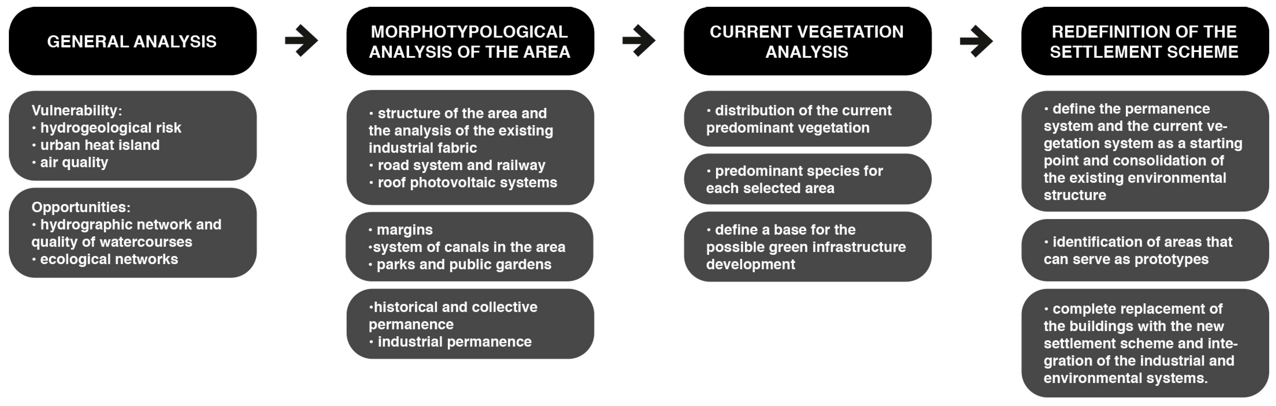
2. Materials and Methods

This research considers the Padua Industrial Zone (ZIP), one of the most vulnerable areas in Southern Europe [29,30,31,32,33], as a test site. This European trade axis has a critical cross in the Venice–Padua–Verona hinterland. As illustrated in Figure 1, the ZIP represents the crossroads of three main trade corridors that cross Europe: the first is Corridor 5, which crosses the continent horizontally from Lisbon to Kyiv, while the others, the Baltic–Mediterranean Corridor and the Scandinavian–Mediterranean Corridor, connect the Nordic countries to the Mediterranean area. The ZIP is also at the termination of the nautical route of the New Silk Road, through which China is reopening trade routes with Europe [34]. This location makes the ZIP a priority area of study on a European and global scale.
Figure 1. Main European trade corridors: Corridor 5 Lisbon–Kyiv, the Baltic–Mediterranean Corridor and the Scandinavian–Mediterranean Corridor (A); routes of the New Silk Road from China to Europe (B).
Sustainability 16 02053 g001
Locally, the ZIP is also a good case study. Since 2010, the Municipality of Padua has become one of the leading players on the national and European scene in mitigation and adaptation to climate change, participating in numerous projects and promoting policies that look towards a more resilient Europe. In 2010, it elaborated its SEAP (Sustainable Energy Action Plan) and joined the EUEU—Covenant of Mayors for Climate and Energy—in the same year. In the following years, it participated in several international projects funded by Horizon 2020, Horizon Europe and LIFE programmes. The European Commission nominated Padua as one of the 100 pilot cities to achieve climate neutrality by 2030. Padua’s SECAP (Sustainable Energy and Climate Action Plan), elaborated in 2021, won the award for best SECAP of the year, assigned by the Covenant of Mayors. Specific studies related to the drafting of the SECAP testify to the fragility of the ZIP in stormwater management, the risk of flooding, and a strong sensitivity to heat waves.
The foundation of the ZIP dates back to 1956, when the Province, the Chamber of Commerce and the Municipality established the Consortium for the industrial zone and the river port of Padua, intending to act as a driver for the area’s economy. Previously, the site presented an agricultural landscape of small and medium-sized plots surrounded by vineyards and wooded areas [35]. It became one of Europe’s most polluted and critical logistic and industrial centres in just a few years. Today, the ZIP, shown in Figure 2 occupies an area of almost 1000 hectares and represents one of the leading production centres in southern Europe with 1500 established companies and about 27,000 workers, not counting those who do not frequent it daily but still need to reach it regularly to carry out their activities. Today, the area is extensively paved and composed mainly of medium-sized industrial buildings. The loss of hydraulic micro-systems and agricultural permeability has significantly increased the ZIP’s fragility [36,37,38].
Figure 2. The industrial district of Padua: map of the current state.
Sustainability 16 02053 g002
A significant factor to consider is the city administration’s interest, expressed in the new Construction Plan Padua 2030 [39] adopted in 2022, concerning the improvement of the city’s production complex, envisaging the transformation of this vital pole into an industrial eco-park of international level (Figure 3).
In addition to the positions of some representatives of the commercial and industrial world, the path promoted by Local Agenda 21, within the Veneto Adapt project, was taken into consideration. On this occasion, listening tables were activated in which the local community and various environmental associations took part. The methodology is summarized here in Figure 4.
Figure 3. Flowchart of the methodology applied for the research.
Sustainability 16 02053 g003
This study examined in depth the prime vulnerability elements that currently have a substantial impact on industrial areas:
  • Hydrogeological risk, using the Municipal Civil Protection Plan as a source, specifically Table 4: Flood Risk [40];
  • Urban heat islands, looking at the Municipal Green Plan, specifically Chapter 03 referring to the Heat Island, where the air temperature map is present [39];
  • Air quality, referring to the data of the ARPAV—Agenzia Regionale per la Prevenzione e Protezione Ambientale Regione Veneto [Regional Agency for Environmental Prevention and Protection] Air Quality Detection Stations [41];
  • Subsequently, factors that constitute an opportunity for the territory from an environmental point of view were also taken into consideration, considering:
  • the hydrographic network and the quality of watercourses, using as a source the monitoring of the ecological status of watercourses conducted by ARPAV [42,43]; and ecological corridors, current and potential vegetation, and fauna [44].
Figure 4. Some of the main characteristics of the district: the structure of the area, formed by the road system, with its perpendicular streets (A); the river system of the peripheral extents (B); the railway which connects the district to the centre of Padua (C); the canal system, considering both surface and underground canals (D).
Sustainability 16 02053 g004
This research was developed in three phases: morpho-typological analysis of the ZIP, outlining the surface structure of the area, the elements that characterize it and the different areas with which it relates; current vegetation assessment, which formed the basis for defining a green infrastructure development strategy; and design of a new settlement scheme, which elaborates a solution for reducing climate risks while increasing the quality of the environment and worker’s life. This research was only developed from certified open data. First, the activity used data released by regional and state administrative bodies and official bodies for environmental protection and research [41,42,43,45,46,47,48]. The activity also used statistical data certified by ISTAT [49,50] and risk data produced on an international scale by EU-ESPON and IPCC [29,51,52,53,54] (Coronato, 2014; Dottori et al., 2022; ESPON—European Spatial Planning Observation Network, s.d.; ESPON, 2022; IPCC, 2018). The activity had to critically combine the materials available from official sources, validating and unifying the statistical aggregates, the level of detail and the significance of the data.
The morpho-typological analysis of the ZIP was also run by conducting on-site visits, collecting extensive photographic documentation and comparing the drawings with satellite images updated to 2022. The analysis carried out was organized into these themes:
  • The structure of the area and the analysis of the existing industrial fabric, taking into consideration factors like the type of buildings present and the ratio between impermeable and permeable surfaces;
  • The margins, mainly consisting of the Piovego, Roncajette and Bacchiglione river areas, make up the northern, western and southern margins, respectively;
  • The road system, considering the primary and secondary roads, how they are structured and what the accesses are;
  • The railway, considering the relationship with Padua station and the development of the secondary track network within the area;
  • The system of canals in the area, including those currently buried [55];
  • The historical and collective permanence that define the areas or building complexes that represent an opportunity for the site or that hold a particular historical value;
  • Industrial permanence that defines manufactories dedicated to productive activities that could hardly be part of the transformation process (Figure 3). In general, the two systems of permanence constituted the invariable factor in the development of the new settlement scheme;
  • The parks and public gardens essential for the development of a green strategy;
  • The roofs that house photovoltaic systems;
  • The abandoned areas.
The second phase was the current vegetation assessment. In a context like the one considered, vegetation, particularly trees, is the best resource for developing a climate change adaptation strategy. Trees, however, are only able to fulfil their role when they are healthy optimally; for this reason, when deciding to plant a new tree, it is fundamental to understand what spontaneous vegetation might be in the area under investigation, to comprehend what is the natural evolution of that area and to try to support it [56].
For this reason, it was necessary to identify the distribution of the current predominant vegetation and species to have an initial outline on which to base a possible green infrastructure development scenario.
This research phase was also conducted by performing numerous site surveys (Figure 5 and Figure 6), subsequently comparing the information through satellite images. These were particularly useful due to the various inaccessible areas in the Industrial Zone. During the surveys, a collection of the species present was also made, subdivided by zone.
Figure 5. The southern warehouses of the Interporto: one of the leading activities of the district.
Sustainability 16 02053 g005
The last research phase was dedicated to defining an alternative settlement scheme, assuming a strategic and long-term approach [7]. The aims that guided the development of the strategy were mainly twofold. Firstly, the area’s transformation had to align with the administration’s vision expressed in the Urban Plan [39], i.e., to aspire to realize an industrial eco-park at an international level. The need for multifunctionality of spaces drove the redefinition of the industrial fabric. The Padua Agri-Food Market was an interesting reference: in addition to being exceptionally efficient and a benchmark for the sector in the region, it is beginning to host various recreational and educational activities within it.
In addition, the extension of its buildings made it possible to set up an efficient solar energy production system on the roofs. Secondly, the principal demand of companies interested in settlement, mainly in the logistics and wholesale sector, is the replacement of medium-sized buildings with larger volumes. Thirdly, the proposed settlement scheme had to cope with the area’s vulnerabilities. In developing a new industrial fabric, the settlement scheme considers it fundamental to develop building roofs as part of the green system. Therefore, the research envisages both intensive and extensive roofing. The transformation of the urban fabric necessarily had to guarantee the development of green infrastructure for reducing heat, drought and flooding. The set of strategies to consolidate the environmental system descends from the distribution of the existing vegetation.
Figure 6. The main abandoned area along Corso Stati Uniti is a significant example of herbaceous vegetation spontaneously growing. Picture made by authors.
Sustainability 16 02053 g006
The research assumes a long-term vision, which is why the possible temporal development of the intervention was also hypothesized (Figure A1):
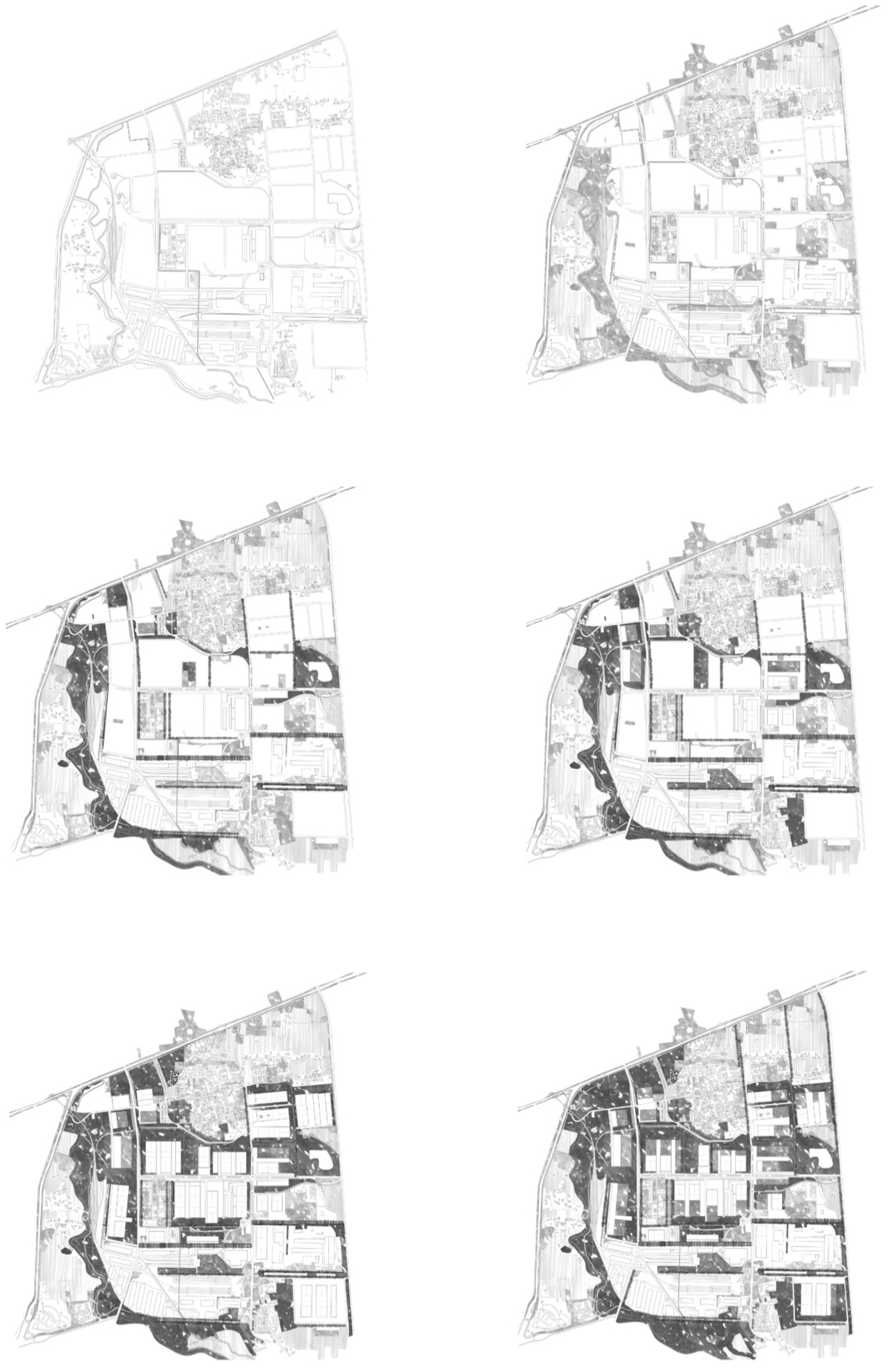
  • The permanence system that defined the intervention areas and the current vegetation system constitute the starting point for the development of the project;
  • The first implementation step consolidates the existing environmental structure as a secondary permanence;
  • The second implementation step concerns the identification of areas that can serve as prototypes for the development of the proposed settlement system, beginning with the replacement of the existing industrial fabric;
  • The third implementation step envisages the complete replacement of the buildings with the new device and the beginning of integration with the established environmental system;
  • The last implementation step will see the complete integration of the industrial and environmental systems.

3. Results

About the morpho-typological analysis of the ZIP, several features emerged from this phase of the research that greatly influenced the development of the new settlement scheme:
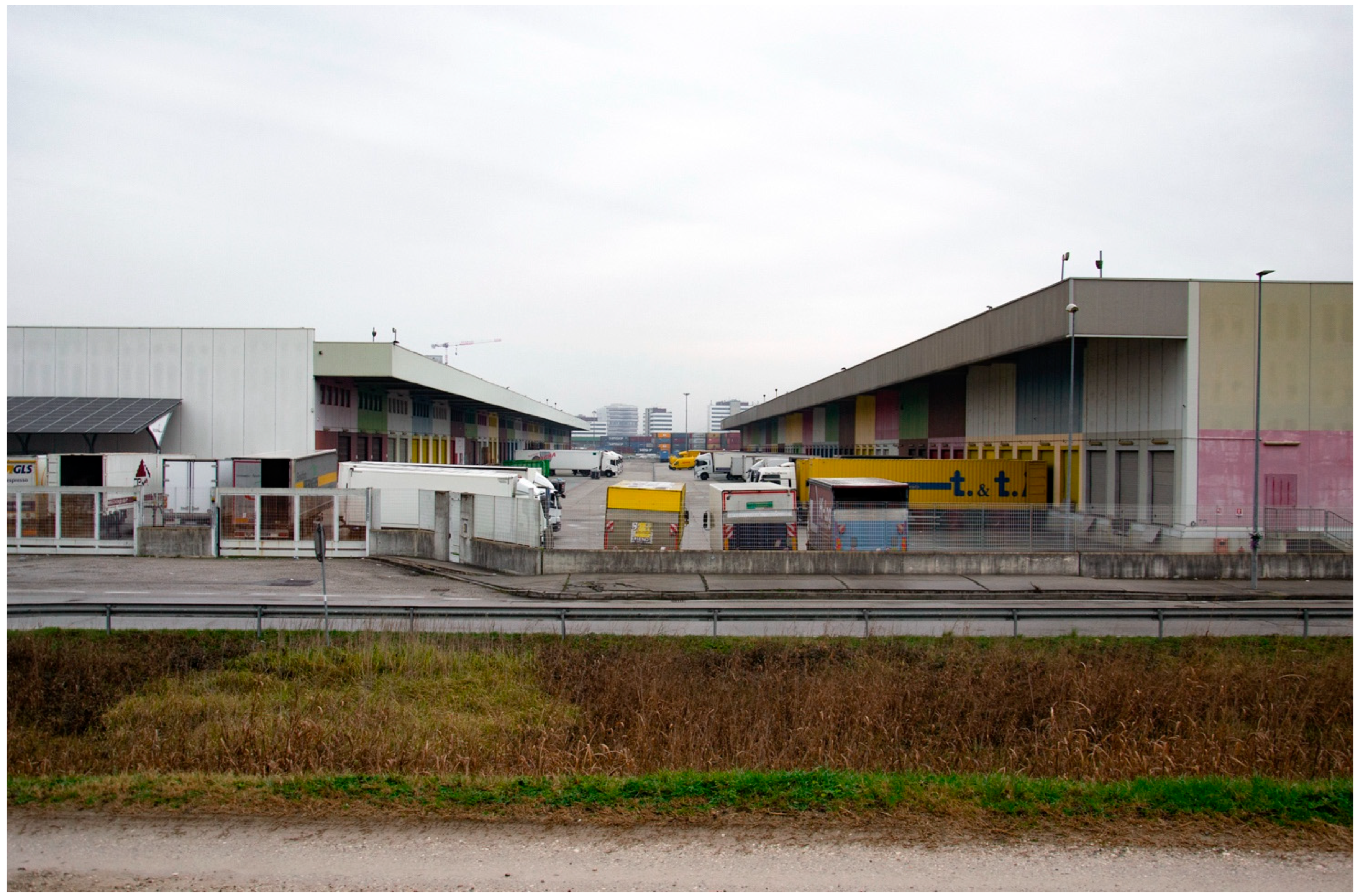
  • The current industrial fabric is marked by a road system with perpendicular axes, which subdivide the area into regular lots (Figure 6). This characteristic enabled the implementation of the new settlement scheme in independent phases. The industrial fabric is highly fragmented, especially in the more marginal areas, made up of small and medium-sized hangars; in the heart of the site, there are instead some very extensive low-rise buildings, often aggregated with other smaller structures. Of particular relevance to this category is Corso Stati Uniti. Along the Corso is the Agri-Food Market, whose articulation was a critical reference point for the development of the project.
  • The marginal areas of the Industrial Zone consist of the waterscapes. The Piovego Canal is to the north, the Roncajette Park is to the west, and the Bacchiglione River is to the south (Figure 7). The Piovego Canal is deficient in natural banks, thus cycle—pedestrian routes, such as the Padua River Ring, were developed along it, connecting the historical centre with its territory. The Bacchiglione, despite the presence of cycle and pedestrian paths similar to the Piovego, has a greater degree of naturalness. Roncajette Park is part of a very naturalized area with bicycle and pedestrian paths. The three watercourses are an integral part of the system of ecological corridors that link the city of Padua to its territory and constitute an essential resource.
  • An active freight railway connecting the ZIP to the Padua station represents an excellent opportunity for the area. The railway connection has the Interporto as its main arrival point; from here, a system of partially active secondary tracks branches off, running through the entire area (Figure 8).
  • For this research, because of the vulnerability of the area concerning water management, the presence of drainage channels, including underground ones, needs to be considered (Figure 8).
  • A further important element is the presence of the residential areas of Camin and Granze di Camin, fragments of the agricultural reality that existed before the construction of the Industrial Area. These two minor urban centres require special attention to avoid degradation and depopulation.
Figure 7. Example of cooperation between buildings. This kind of relationship shows the considerable potential of the settlement scheme, which offers a second layer of use above the buildings.
Sustainability 16 02053 g007
Figure 8. Concept of the numerous benefits brought by the settlement scheme proposed. It considers some crucial aspects, such as green roofs and solar energy production.
Sustainability 16 02053 g008
The ZIP represents a particularly extreme habitat for vegetation development. The area is almost wholly waterproof, and the only fragments of permeable soil are relegated to flowerbeds and abandoned lots. Despite expectations, however, it was possible to identify a discrete presence of vegetation, represented by relatively fragmented heterogeneous elements such as rows of trees, abandoned lots, flowerbeds, parks and gardens. The areas with the most significant degree of naturalness are the riverside areas that develop on the edges. These connect the city with the surrounding area, hold great value as ecological corridors, and represent a possible matrix for developing the environmental system to the innermost extent.
The most complex vegetation is that of the marginal areas, where there are fragments of potential vegetation, with the presence of oak (Quercus robur L.), hornbeam (Carpinus betulus L.) and elm (Ulmus minor Mill.). Along the watercourses, fragments of hygrophilous woodland are present, characterized by white willow (Salix alba L.), black poplar (Populus nigra L.) and white poplar (Populus alba L.). This area also sees the presence of various allochthonous species, mainly black locust (Robinia pseudoacacia L.) and false indigo (Amorpha fruticosa L.). Also considered is the vegetation within the area, primarily consisting of bare flower beds characterized by herbaceous species and rows of linden trees (Tilia cordata Mill.) The urban centres of Camin and Granze di Camin are home to several parks and gardens, particularly important for the frequent presence of evergreens such as the cedar of Lebanon (Cedrus libani A. Rich.) or the cypress (Cupressus sempervirens L.). Abandoned plants of various sizes are scattered throughout the industrial area, characterized mainly by colonizing herbaceous species. These species are also present along the main roads and the railway, the edges of which are often characterized by intensely developed vegetation.
The new settlement scheme was rooted in two main themes to achieve the research aims. The first refers to an optimal aggregation of the existing built stock, counteracting the fragmentation of the existing industrial fabric that allows us to reduce the residual spaces between buildings and have more space available for the green system. The second refers to the multifunctionality of spaces. Multifunctionality is a feature that should not only concern the green infrastructure system but must also be a requirement of architectural development. For these reasons, the proposal envisages that new ones will progressively replace the existing trim and medium-sized monofunctional sheds. A strategy based on massive buildings could bring numerous benefits (Figure 7), including:
  • The development of an ecologically and environmentally efficient green roofing system that contributes to decreasing the heat island effect, reduces stormwater runoff and promotes biodiversity;
  • The development of a roofing system for energy production, with some photovoltaic panels that can contribute substantially to energy production and affect the buildings’ needs;
  • The simplification of the access system would make it possible to recover surface area for green areas, especially along roads;
  • The design of buildings on a modular principle would allow different needs, giving coherence and distinctiveness to the site;
  • This solution can bring benefits even when considering a single building; however, it is the combination of the different blocks (Figure 9) that expresses the different potentials;
  • The green roofs of the single block can be included in a system of different habitats, proposing the inclusion of a large number of species according to several needs;
  • Energy production can also be diversified or based on covering part of roof space with photovoltaic panels;
  • Between the individual blocks, there are work squares, spaces of variable size that can accommodate the different activities envisaged, also taking into account the manoeuvring room for heavy vehicles;
  • The space of the roofs can also accommodate community uses, related to each other by elevated walkways, to create a connected system of public spaces;
  • The modularity that characterizes the plan can also be applied in the elevation, generating a system of overlapping blocks in which the second can accommodate mainly executive functions and services;
  • The individual blocks interact through a system of embankments where, at the base, there is a channel for collecting runoff water.
Figure A2 shows a general master plan depicting how applying the settlement scheme can effectively provide space for the required ecosystem services. The figure also shows the availability of large logistical and industrial buildings and space for facilities without reducing the manoeuvring requirements of a transit area for large vehicles.
Figure 9. Scheme of the production system proposed.
Sustainability 16 02053 g009

4. Discussion

The research outcome defines a settlement scheme that operates on two parallel fronts. One front faces the system of streets and their relationship with the new buildings, which form part of a mineral world in which vehicles and goods circulate (Figure 9). The other front faces the system of green spaces and roofs, which constitutes a predominantly vegetational domain intended for public use and capable of counteracting the impact of extreme climatic events (Figure 10).
Figure 10. Scheme of the green infrastructure distribution.
Sustainability 16 02053 g010
This dual approach aligns with the nature of the Dutch examples presented above. This research purports to bring new applicability to the projects considered examples by demonstrating their effectiveness even in currently totally grey areas. The current urban model gives space to a model based more on the need to build environments that are adaptable, flexible and open to change [7]. These characteristics constitute an asset not only for the case study, but also for addressing problems common to most European and Mediterranean industrial and logistics areas, where the proposed model would retain its effectiveness. This is easily linked to the UN Sustainable Development Goals (8.4, 8.8; 9.1, 9.4; 11.5, 11.6, 11.7, 11.a; 13.1; 15.5, 15.8, 15.9, 15.a), which transpose the proposed approach into a global perspective [57,58].
In this process, the multifunctionality of spaces plays a fundamental role. In the new ZIP, buildings become an integral part of a system of spaces that hold both a productive function and an environmental and social one. A complete application of the scheme can green the same amount of needed built area, which can be made permeable and included in a new vegetation system. The structure of the new industrial fabric would allow the administration to divide the replacement of the built-up area, adapting the new blocks each time according to different needs without losing the entire sense and purpose.
On the ecosystemic aspects, the development of the new settlement scheme fits into a system of a modified nature [7,59], capable of progressively accommodating infrastructures and workplaces. At the same time, it ensures the development and preservation of ecosystems, favouring the action of natural systems to reduce the risks linked to the climate crisis. The project is testable according to three ecosystem development scenarios: wetlands and water, pollinators and avifauna, trees and vegetation.
For wetlands, the project will favour the development of phyto-purification. The second ecosystem value is the management of rainwater. Through a system of artificial slopes and ponds, they will be able to accommodate runoff water, thus reducing the risk of flooding. The third value is the reconnection of ecological corridors in a river park. The areas near the Piovego Canal section, which runs through the industrial area, will be progressively cleared to allow the continuity of ecosystems. The fourth value is the increase of slow infiltration of first rainwater, which will favour the supply from the water table, now scarce due to rapid runoff through drainage channels. Finally, several canals in the industrial area are currently buried. Where possible, the larger available space generated by the aggregation of buildings will bring the canals back into the light, favouring cooling and the development of flora and fauna.
The canals of the ZIP not buried in the area are characterized by deficient naturalness, with impermeable walls almost everywhere. Today, the banks of the Piovego are almost devoid of large masses of vegetation, and the banks are constantly kept free. The renaturalization of the area will favour hosting various plant and animal species and mending ecological corridors. These systems will be helpful as possible nesting sites for different bird species. It is essential to favour tree species such as the cypress within the area and at the edges, near the more natural areas, which, with its compact foliage, provides a nesting and sheltering site for small birds.
Furthermore, by increasing the presence of herbaceous and geophytic species with diversified flowering, the canals can become a highway for pollinators, connecting the city centre with the surrounding agricultural areas. Finally, large grassland extents in these areas can be preserved with reduced or rotational mowing. Significant floristic variability is expected in the lawn area’s location and size. This variety will attract pollinating insects and valuable entomofauna for pollination.
In addition, vegetation will expand by greening abandoned areas, promoting soil regeneration. Street trees will extend into the industrial area, increasing efficiency and liveability for pollinators. Upon completion of the project, a ring of protection and filtering from industrial activities will be formed, with particular emphasis on evergreen species. The primary ecosystem services of this vegetation system will be cooling, air purification, and the fixation of climate-altering gases. Furthermore, this extensive natural system will develop important landscape values for workers and occasional users. Finally, through the management of the tree systems, there will be a considerable increase in biomass for energy production.
The assessment of the actual ecosystem values described here is achievable with Burkhard’s matrix [60,61,62,63] and suggests starting with a redetermination of the soil type at the end of the project, a substantial increase in the sustainability of the area.
The fostered ecosystem services interact due to their inherent characteristic of multifunctionality. The project vision of the environmental system, therefore, consists of a series of individual actions that simultaneously lead, on the one hand, to the reinforcement of the natural matrix represented by the river margins and, on the other hand, to the increase of the minor elements within the area, such as rows, canals and green areas. The project thus leads to progressive contamination of the productive spaces by the environmental system, seeking to favour the continuity of the different ecosystems.
The most significant limitation of this proposal is the current fragmentation of the properties. Nevertheless, the advantages of the new types of buildings, the possibility of meeting part of the energy needs independently, and the substantial improvement in the quality of the working environment constitute a meeting point that could favour the development of the initiative. Furthermore, most of the interventions concerning green infrastructure are independent of the built-up area. The proposed strategies contribute to the connectivity of ecosystems and their protection, safeguarding the ecosystem services they provide and, at the same time, contributing to climate change mitigation and adaptation. Thirdly, the lots’ great value and the ZIP’s position in the European commodities system can encourage great companies to invest in the redevelopment.

5. Conclusions

The research presented in this article was developed by imagining a possible evolution of the urban fabric of the ZIP to propose an alternative settlement scheme that was able to respond positively to the impacts of the climate crisis. Based on the multifunctionality of the parts and the expansion of green infrastructures, the proposed strategy allows us to imagine a development process for the industrial area in which it is possible to combine the productive world with a complex system of green spaces of high environmental and social value. The proposed research assumes that it is not possible to act on the adaptation of urban areas without questioning the configuration of the built environment. The project encourages courageous transformations that can lead to large-scale goals, trying to overcome a ‘lot-by-lot’ approach. Although it arises from research based on the specificities of the area considered, the method used and the settlement scheme identified can serve as a model for the transformation of similar contexts into a scenario of adaptation to climate change.

Author Contributions

Conceptualization, M.B.; methodology, M.B. and E.V.; formal analysis, E.V.; investigation, M.B. and E.V. Writing was performed by both authors. M.B. particularly cured Section 1, Section 2 and Section 4; E.V. particularly cured Section 2, Section 3 and Section 5. All authors have read and agreed to the published version of the manuscript.

Funding

This research was funded by PNRR-Piano Nazionale di Ripresa e Resilienza, Missione 4 «istruzione e Ricerca», Componente 2 Investimento 1.5, Ecosistema INEST-Interconnected Nord-Est Innovation, Spoke 4. The research coordinator for Spoke 4 is Lorenzo Fabian.

Data Availability Statement

The data presented in this study are available on request from the corresponding author.

Conflicts of Interest

The authors declare no conflicts of interest.

Appendix A

Figure A1. Stages of development of the settlement scheme. The different phases show the strong relationship between vegetation development and buildings.
Sustainability 16 02053 g0a1
Figure A2. Map of the final proposal for the transformation of the industrial district of Padua, in particular considering the area of Corso Stati Uniti.
Sustainability 16 02053 g0a2

References

  1. Bertin, M.; Maragno, D.; Musco, F. Pianificare l’adattamento al cambiamento climatico come gestione di una macro-emergenza locale. Territorio 2019, 89, 138–144. [Google Scholar] [CrossRef]
  2. Besteliu, I.; Doevendans, K. Planning, Design and the Post-Modernity of Cities. Philos. Des. 2002, 23, 233–244. [Google Scholar] [CrossRef]
  3. McCartney, M. Paul Romer, Charter Cities and Lessons from Historical Big Infrastructure? Cities 2022, 131, 103898. [Google Scholar] [CrossRef]
  4. Begum, R.A.; Sarkar, M.S.K.; Jaafar, A.H.; Pereira, J.J. Toward Conceptual Frameworks for Linking Disaster Risk Reduction and Climate Change Adaptation. Int. J. Disaster Risk Reduct. 2014, 10, 362–373. [Google Scholar] [CrossRef]
  5. Bosselmann, P. Transformations and City Extensions: Some Observations of Copenhagen’s City Form at a Time of Global Change. J. Urban Des. 2002, 7, 75–97. [Google Scholar] [CrossRef]
  6. Burgalassi, D.; Luzzati, T. Urban Spatial Structure and Environmental Emissions: A Survey of the Literature and Some Empirical Evidence for Italian NUTS 3 Regions. Cities 2015, 49, 134–148. [Google Scholar] [CrossRef]
  7. Lennon, M.; Scott, M.; O’Neill, E. Urban Design and Adapting to Flood Risk: The Role of Green Infrastructure. J. Urban Des. 2014, 19, 745–758. [Google Scholar] [CrossRef]
  8. Shi, Y.; Zhao, S. Discover the Desirable Landscape Structure for Mitigating Urban Heat: The Urban-Rural Gradient Approach for an Ancient Chinese City. Cities 2022, 127, 103737. [Google Scholar] [CrossRef]
  9. Broberg, P. The Evolution of Industrial Building. Spec. Issue Des. Coalit. Team 1986, 7, 144–152. [Google Scholar] [CrossRef]
  10. Cotsaftis, O.; Williams, N.; Chyon, G.; Sadar, J.; Va Pesaran, D.M.; Wines, S.; Naarden, S. Designing Conditions for Coexistence. Des. Stud. 2023, 87, 101199. [Google Scholar] [CrossRef]
  11. Holman, I.P.; Harrison, P.A.; Metzger, M.J. Cross-Sectoral Impacts of Climate and Socio-Economic Change in Scotland: Implications for Adaptation Policy. Reg. Environ. Chang. 2016, 16, 97–109. [Google Scholar] [CrossRef]
  12. Berke, P.R.; Song, Y.; Stevens, M. Integrating Hazard Mitigation into New Urban and Conventional Developments. J. Plan. Educ. Res. 2009, 28, 441–455. [Google Scholar] [CrossRef]
  13. Berke, P.R.; Campanella, T.J. Planning for Postdisaster Resiliency. Ann. Am. Acad. Pol. Soc. Sci. 2006, 604, 192–207. [Google Scholar] [CrossRef]
  14. De Solà-Morales, M. Verso Una Definizione. Analisi Delle Espansioni Urbane Dell’800 Towards a Definition. Analysis of Urban Growth in the Nineteenth Century. Lotus Int. 1978, 19, 18–35. [Google Scholar]
  15. Fields, B. From Green Dots to Greenways: Planning in the Age of Climate Change in Post-Katrina New Orleans. J. Urban Des. 2009, 14, 325–344. [Google Scholar] [CrossRef]
  16. Mumford, L. La Città Nella Storia. The City in History; Edizioni di Comunità: Milano, Italy, 1963. [Google Scholar]
  17. Osmólska, D.; Lewis, A. Architects’ Use of Intuition in Site Analysis: Information Gathering in Solution Development. Des. Stud. 2023, 87, 101189. [Google Scholar] [CrossRef]
  18. Caretta, M.A.; Mukherji, A.; Arfanuzzaman, M.; Betts, R.A.; Gelfan, A.; Hirabayashi, Y.; Lissner, T.K.; Lopez Gunn, E.; Liu, J.; Morgan, R.; et al. Water. In Climate Change 2022: Impacts, Adaptation and Vulnerability. Contribution of Working Group II to the Sixth Assessment Report of the Intergovernmental Panel on Climate Change; Pörtner, H.-O., Roberts, D.C., Tignor, M.M.B., Poloczanska, E.S., Mintenbeck, K., Alegría, A., Craig, M., Langsdorf, S., Löschke, S., Möller, V., et al., Eds.; Cambridge University Press: Cambridge, UK, 2022. [Google Scholar]
  19. Palazzo, E. From Water Sensitive to Floodable: Defining Adaptive Urban Design for Water Resilient Cities. J. Urban Des. 2019, 24, 137–157. [Google Scholar] [CrossRef]
  20. Burby, R.J.; Beatley, T.; Berke, P.R.; Deyle, R.E.; French, S.P.; Godschalk, D.R.; Kaiser, E.J.; Kartez, J.D.; May, P.J.; Olshansky, R.; et al. Unleashing the Power of Planning to Create Disaster-Resistant Communities. J. Am. Plann. Assoc. 1999, 65, 247–258. [Google Scholar] [CrossRef]
  21. Olasky, M. The Politics of Disaster: Katrina, Big Government, and a New Strategy for Future Crises; Thomas Nelson: Nashville, TN, USA, 2006; ISBN 1-4185-5458-8. [Google Scholar]
  22. Highfield, W.E.; Peacock, W.G.; Van Zandt, S. Mitigation Planning: Why Hazard Exposure, Structural Vulnerability, and Social Vulnerability Matter. J. Plan. Educ. Res. 2014, 34, 287–300. [Google Scholar] [CrossRef]
  23. Peacock, W.G.; Van Zandt, S.; Zhang, Y.; Highfield, W.E. Inequities in Long-Term Housing Recovery after Disasters. J. Am. Plann. Assoc. 2014, 80, 356–371. [Google Scholar] [CrossRef]
  24. Appler, D.; Rumbach, A. Building Community Resilience Through Historic Preservation. J. Am. Plann. Assoc. 2016, 82, 92–103. [Google Scholar] [CrossRef]
  25. Lewis, D.; Mioch, J. Urban Vulnerability and Good Governance. J. Contingencies Crisis Manag. 2005, 13, 50–53. [Google Scholar] [CrossRef]
  26. Quigley, M.; Blair, N.; Davison, K. Articulating a Social-Ecological Resilience Agenda for Urban Design. J. Urban Des. 2018, 23, 581–602. [Google Scholar] [CrossRef]
  27. Kullmann, K. Green-Networks: Integrating Alternative Circulation Systems into Post-Industrial Cities. J. Urban Des. 2013, 18, 36–58. [Google Scholar] [CrossRef]
  28. Stefan, A. Multi-Functional Urban Design Approaches to Manage Floods: Examples from Dutch Cities. J. Urban Des. 2022, 27, 270–278. [Google Scholar] [CrossRef]
  29. ESPON. ESPON CLIMATE—Climate Change and Territorial Effects on Regions and Local Economies in Europe. 2022. Available online: https://www.espon.eu/climate (accessed on 9 January 2024).
  30. Fabian, L.; Bertin, M. Italy Is Fragile: Soil Consumption and Climate Change Combined Effects on Territorial Heritage Maintenance. Sustainability 2021, 13, 6389. [Google Scholar] [CrossRef]
  31. Maragno, D.; Gaglio, M.; Robbi, M.; Appiotti, F.; Fano, E.A.; Gissi, E. Fine-Scale Analysis of Urban Flooding Reduction from Green Infrastructure: An Ecosystem Services Approach for the Management of Water Flows. Ecol. Model. 2018, 386, 1–10. [Google Scholar] [CrossRef]
  32. Maragno, D.; Dalla Fontana, M.; Musco, F. Mapping Heat Stress Vulnerability and Risk Assessment at the Neighborhood Scale to Drive Urban Adaptation Planning. Sustainability 2020, 12, 1056. [Google Scholar] [CrossRef]
  33. Musco, F.; Fregolent, L.; Ferro, D.; Magni, F.; Maragno, D.; Martinucci, D.; Fornaciari, G. Mitigation of and Adaptation to UHI Phenomena: The Padua Case Study. In Counteracting Urban Heat Island Effects in a Global Climate Change Scenario; Springer International Publishing: Cham, Switzerland, 2016; pp. 221–256. [Google Scholar]
  34. Li, Y.; Schmerer, H.-J. Trade and the New Silk Road: Opportunities, Challenges, and Solutions. J. Chin. Econ. Bus. Stud. 2017, 15, 205–213. [Google Scholar] [CrossRef]
  35. Squizzato, M.; Ravazzolo, P. Sessant’anni Fa… Solo Una Scommessa: La Zona Industriale Di Padova: Da Ruralità a Industrializzazione; Il Prato: Saonara, Italy, 2020. [Google Scholar]
  36. Been, V.; Ellen, I.G.; Weselcouch, M. Density and Disaster: New Models of Disaster Recovery for Housing in High-Density Cities. J. Am. Plann. Assoc. 2014, 80, 372. [Google Scholar] [CrossRef]
  37. Birkmann, J.; von Teichman, K. Integrating Disaster Risk Reduction and Climate Change Adaptation: Key Challenges-Scales, Knowledge, and Norms. Sustain. Sci. 2010, 5, 171–184. [Google Scholar] [CrossRef]
  38. Negretto, V.; Giacomello, E.; Gava, B.; Romanato, N. Linee Guida per Il Drenaggio Urbano Sostenibile: Tecniche e Principi per La Pianificazione Urbanistica [Guidelines for Sustainable Urban Drainage: Techniques and Principles for Urban Planning]; Corila: Venezia, Italy, 2021. [Google Scholar]
  39. Commune di Padova. Di Piano Degli Interventi del Comune di Padova [Operative Urban Plan of the Municipality of Padua]. 2023. Available online: https://www.padovanet.it/informazione/piano-degli-interventi-pi-mappa-interattiva-ed-elaborati (accessed on 9 January 2024).
  40. Commune di Padova. Di Piano Comunale di Protezione Civile—Comune di Padova [Municipal Civil Protection Plan]. Available online: https://www.padovanet.it/informazione/piano-comunale-di-protezione-civile (accessed on 15 August 2023).
  41. ARPA Veneto. Relazione Regionale Qualità Dell’aria 2022 [Regional Air Quality Report 2023]. Available online: https://www.arpa.veneto.it/temi-ambientali/aria/rapporti-annuali (accessed on 15 August 2023).
  42. ARPAV Veneto. Rapporto sullo Stato dell’Ambiente del Veneto—Anno. 2020. Available online: https://www.arpa.veneto.it/arpavinforma/pubblicazioni/rapporto-sullo-stato-dellambiente-del-veneto-anno-2020 (accessed on 15 August 2023).
  43. ARPAV Veneto. Stato Ambientale Dei Corpi Idrici Del Bacino Scolante Nella Laguna di Venezia Anno 2021 [Environmental Status of Water Bodies in the Venice Lagoon Drainage Basin Year 2021]. Available online: https://www.arpa.veneto.it/temi-ambientali/acque-interne/acque-interne/bacino-scolante/index_html (accessed on 15 August 2023).
  44. Commune di Padova. Di Piano Urbano Della Mobilità Sostenibile—Pums Di Padova—Comune Di Padova [Urban Sustainable Mobility Plan]. Available online: https://www.padovanet.it/informazione/piano-urbano-della-mobilit%C3%A0-sostenibile-pums-di-padova#33600 (accessed on 15 August 2023).
  45. ARPA FVG. Il Clima Del Friuli Venezia Giulia; Rapporto 2023; ARPA FVG: Palmanova, Italy, 2023. [Google Scholar]
  46. DPC. Available online: https://rischi.protezionecivile.gov.it/it/meteo-idro-0/ (accessed on 8 January 2024).
  47. ISPRA. Annuario Dei Dati Ambientali—Edizione 2019; ISPRA: Roma, Italy, 2020; ISBN 978-88-448-0975-1.
  48. ISPRA. Atlante nazionale del consumo di suolo. Edizione 2023; ISPRA: Roma, Italy, 2023; ISBN 978-88-448-1180-8.
  49. ISTAT. Rapporto Annuale 2023. 2023. Available online: https://www.istat.it/it/archivio/286191 (accessed on 9 January 2024).
  50. ISTAT. Available online: https://www.istat.it/it/archivio/286364 (accessed on 18 August 2023).
  51. Coronato, M. Capitalisation and Dissemination of ESPON Concepts–ESPON CaDEC. The Italian Experience. In ESPON Italian Evidence in Changing Europe; STF: Roma, Italy, 2014; pp. 139–142. ISBN 88-909765-2-7. [Google Scholar]
  52. Dottori, F.; Alfieri, L.; Bianchi, A.; Skoien, J.; Salamon, P. A New Dataset of River Flood Hazard Maps for Europe and the Mediterranean Basin. Earth Syst. Sci. Data 2022, 14, 1549–1569. [Google Scholar] [CrossRef]
  53. ESPON Transportation. Available online: https://database.espon.eu/search/?f=topics_exact:Transport%20and%20Accessibility (accessed on 25 January 2024).
  54. IPCC. Global Warming of 1.5 °C: IPCC Special Report on Impacts of Global Warming of 1.5 °C above Pre-Industrial Levels in Context of Strengthening Response to Climate Change, Sustainable Development, and Efforts to Eradicate Poverty; Cambridge University Press: Cambridge, UK, 2018. [Google Scholar]
  55. Consorzio di Bonifica Bacchiglione Piano Generale di Bonifica e di Tutela del Territorio [General Land Drainage and Land Protection Plan]. Available online: https://www.consorziobacchiglione.it/il-consorzio/piano-generale-di-bonifica-e-di-tutela-del-territorio.html (accessed on 15 August 2023).
  56. Filesi, L. La Pianta Giusta al Posto Giusto. In Diritto e Città Verde; Roversi Monaco, M., Brocca, M., Eds.; Mimesis: Milano, Italy, 2023. [Google Scholar]
  57. Flogard, E.L.; Mengshoel, O.J. A Dataset for Efforts Towards Achieving the Sustainable Development Goal of Safe Working Environments. Adv. Neural Inf. Process. Syst. 2022, 35, 23297–23310. [Google Scholar]
  58. Mondal, S.; Lee, M.-A.; Weng, J.-S.; Osuka, K.E.; Chen, Y.K.; Ray, A. Seasonal Distribution Patterns of Scomberomorus Commerson in the Taiwan Strait in Relation to Oceanographic Conditions: An Ensemble Modeling Approach. Mar. Pollut. Bull. 2023, 197, 115733. [Google Scholar] [CrossRef]
  59. Ungers, O.M.; Koolhaas, R.; Riemann, P.; Kollhoff, H.; Ovaska, A. La Città Nella Città. Proposte Della Sommer Akademie per Berlino [Cities within the City. Proposals by the Sommer Akademie for Berlin]. Lotus Int. 1979, 19, 82–98. [Google Scholar]
  60. Burkhard, B.; Kroll, F.; Nedkov, S.; Müller, F. Mapping Ecosystem Service Supply, Demand and Budgets. Ecol. Indic. 2012, 21, 17–29. [Google Scholar] [CrossRef]
  61. Burkhard, B.; Kandziora, M.; Hou, Y.; Müller, F. Ecosystem Service Potentials, Flows and Demands-Concepts for Spatial Localisation, Indication and Quantification. Landsc. Online 2014, 34, 1–32. [Google Scholar] [CrossRef]
  62. Burkhard, B.; Maes, J. An Operational Framework for Integrated Mapping and Assessment of Ecosystems and Their Services (MAES); Burkhard, B., Santos-Martin, F., Nedkov, S., Eds.; Gottfried Wilhelm Leibniz Universität Hannover Technische Informationsbibliothek (TIB): Hannover, Germany, 2018; Volume S, p. e22831. [Google Scholar] [CrossRef]
  63. Burkhard, B.; Maes, J. (Eds.) Mapping Ecosystem Services; Pensoft Publishers: Sofia, Bulgaria, 2017; ISBN 978-954-642-830-1. [Google Scholar]
Disclaimer/Publisher’s Note: The statements, opinions and data contained in all publications are solely those of the individual author(s) and contributor(s) and not of MDPI and/or the editor(s). MDPI and/or the editor(s) disclaim responsibility for any injury to people or property resulting from any ideas, methods, instructions or products referred to in the content.

