1. Introduction
The olive tree is considered one of the most widespread trees in the Arab world, especially in countries bordering the Mediterranean Sea. This widespread presence is closely linked with the historical economic, environmental and social significance of the olive in these countries. Olive domestication originated in its native regions of the eastern Mediterranean basin around 6000 years ago. It is cultivated at latitudes between 27 and 44° north because a warm temperate climate characterizes this latitude. The olive tree is one of the common trees in the Arab World, specifically within the countries that surround the Mediterranean Sea. The lengthy presence is interrelated with the economic, environmental and social importance the olive has in those countries [
1,
2,
3].
In ancient times, olive trees in the Mediterranean region were much more than an economic source. Further, traditional trees typical in the olive orchards created diversified and harmonized environmental conditions that led to stability [
4]. These trees also assured numerous opportunities for communities, constituting the social and cultural structures of the territories involved [
5].
The most important crop in Jordan is olives, for which Jordan has realized self-sufficiency since the year 2000 in table olives and olive oil as considered the economic crop. In addition, this reveals the state’s cultivation of olive groves and the development in cultivating this area. However, the numbers indicate a decline in the cultivated olive tree area in Jordan. In 2016, it grew to 637 square kilometers, while in 2017, it became 562 square kilometers. On the other hand, olive trees increased in Jordan from 8.4 million trees in 2016 to 10.5 million trees in 2017 [
6,
7].
Climate change is projected to be one of the primary causes of decreasing levels of food security [
8] in the Arab world over the next decades due to the sharp decrease in agricultural productivity resulting from the increase in temperatures and the reduction in rainfall [
9]. The world faces increased challenges in production relating to agriculture; among them, severe climate change is most prominent. This phenomenon is no longer limited to agricultural production but has encompassed all economic sectors [
10]. Climate conditions are at the forefront of factors influencing the vitality and freshness of olive trees, in addition to soil conditions, farming practices, fertilization and tree care [
11]. This is particularly significant as the majority of olive trees are grown in upland areas where annual rainfall is substantial, typically exceeding several hundred millimeters [
12], while the rest are cultivated under irrigation. Rainfall amounts and the variability in their distribution are among the key factors influencing olive cultivation and production [
13].
Many studies have examined the impact of climate change on olive production, ranging from local and regional levels to international perspectives. For instance, a study by Khateeb [
14] titled “The Impact of Climate on Olive Productivity in the West Bank” aimed to investigate the characteristics of olive cultivation in the West Bank and assess the environmental factors influencing olive productivity. One of its key findings was the existence of a direct relationship between rainfall amounts and productivity at various stages of olive tree growth.
The existing body of literature provides valuable insights into the impact of climate change on olive production across different geographical regions. For instance, Orlandi et al. [
15] conducted a comprehensive study titled “The Impact of Climate Change on Olive Productivity in Italy”. Their research delved into time series data encompassing olive pollen grains from 1999 to 2012 across 16 Italian provinces. Findings from this investigation revealed a negative correlation between maximum temperature during spring and summer and olive production, whereas a consistently positive correlation with rainfall was observed. Furthermore, the study identified drought conditions in certain Italian regions as a significant threat to olive production.
Similarly, Gratsea et al. [
16] conducted research titled “Long-Term Climate Change Effects on Olive Crops and Olive Fly in Andalusia, Spain”. This study aimed to investigate the long-lasting impacts of climate change on olive crops in Andalusia, a region renowned for olive cultivation. The researchers employed specialized climate indicators and performed return period analyses. The study’s findings underscored the significant challenges that climate change presents to olive production, particularly concerning the risks posed by the olive fly.
Furthermore, Rodrigo-Comino et al. [
17] investigated the impact of prolonged rainfall variability on olive production and farmer income in Belén, a municipality situated in the province of Jaén, Spain. This study focused on understanding the influence of fluctuating rainfall amounts on olive-farming practices and the economic sustainability of local farmers. Advanced statistical methodologies were applied to analyze extensive historical data, uncovering changes in rainfall quantities and their implications for olive crop productivity, quality and the financial well-being of farmers.
Kandel et al. [
18] investigated suitable locations for olive cultivation in ten mountainous regions of northwestern Nepal, focusing on the wild olive plant which thrives in these terrains. Using multi-criteria analysis (MCA) combined with Geographic Information Systems (GISs), the study aimed to identify areas conducive to wild olive cultivation. The evaluation incorporated six criteria, with three related to climate factors—temperature, relative humidity and rainfall—and three tied to topographical aspects—elevation, aspect and slope. The findings, illustrated on a suitability map, showed that approximately 1.02% of the total study area was highly suitable for olive cultivation, while the majority was unsuitable.
However, a critical issue identified by Kandel et al. [
18] is the general increase in temperatures across olive-cultivation areas. This warming trend can detrimentally affect olive tree growth by causing soil drying and accelerating water evaporation. Additionally, the increasing frequency and severity of weather extremes, such as droughts and floods, can lead to irregular rainwater accumulation or excessive drying. These fluctuations can damage the roots and trees, impacting both the quality and quantity of the fruit produced. Changes in rainfall patterns, including variations in amount and timing, can also significantly affect the growth periods and production cycles of olive trees. For instance, heavy rainfall over short periods can result in water accumulation and flooding, harming plant roots and disrupting the pollination process by reducing the transfer of pollen between flowers, thus affecting fruit formation. These climatic changes pose significant challenges to olive cultivation, affecting productivity and fruit quality. Identifying and assessing these impacts are crucial for developing strategies to adapt to climate change and enhance productivity.
On the other hand, various studies have explored methods to convert unsuitable areas into viable agricultural land. For instance, Ref. [
19] analyzed the expansion of olive orchards in Cordoba, Spain, and highlighted how legislation promoting farming intensification through irrigation and high tree densities could transform previously unsuitable cereal cropland into productive olive orchards. This expansion resulted in a mosaic of orchards with different characteristics, contributing to the regional agricultural landscape’s sustainability by considering potential restoration areas to enhance ecosystem services.
Similarly, Ref. [
20] investigated the effects of organic and inorganic fertilization combined with different irrigation strategies on soil and tree parameters in olive groves. Their findings suggested that the addition of compost, particularly in hedgerow systems, significantly increased soil water retention and organic matter content. This practice, coupled with deficit irrigation strategies, proved effective in enhancing fruit production and promoting a circular economy and water conservation.
Additionally, Ref. [
21] studied the impact of maintaining spontaneous weed cover in olive groves on carbon assimilation and water-use efficiency. They found that although weed-free treatments initially showed higher leaf-scale carbon assimilation, the presence of weeds increased annual ecosystem carbon uptake and improved water-use efficiency during certain periods. These results indicate that maintaining weed cover could be a viable strategy for improving the suitability of olive-cultivation areas by enhancing soil moisture and reducing water stress on olive trees.
These studies underline the importance of integrating innovative agricultural practices and technological solutions to convert unsuitable areas into productive olive groves, thereby contributing to sustainable agricultural development.
The current study aims to analyze the current and expected impact of climate change on olive tree productivity. It also examines the effects of rising temperatures, changing rainfall patterns and increased weather extremes on olive fruit growth. Additionally, it identifies the challenges and risks facing olive productivity due to climate change.
The importance of studying the impact of climate change on olive productivity lies in providing more detailed insights to develop suitable strategies for adaptation and resilience, ensuring the continuity of agricultural production in the face of increasing climate challenges. Therefore, studying the effects of climate change on olive productivity is of utmost importance due to the growing challenges faced by the agricultural sector as a result of climate change, which heavily relies on climate elements such as rainfall, temperature, wind and humidity.
Furthermore, olive cultivation is closely tied to the cultural and economic heritage of Jordan that rely on this type of agriculture. Hence studying the impact of climate change on olive productivity is considered essential in preserving this heritage and promoting the sustainability of this sector. According to the study’s findings, it can be suggested to improve olive farming practices by adopting climate-adaptive agricultural techniques.
2. Materials and Methods
2.1. Study Area
Due to its geographical location between latitudes 33°, 29° north and longitudes 39°, 34° east as shown in
Figure 1, Jordan experiences a moderate desert climate [
22]. This places it within the arid and semi-arid belt, characterized by long, hot summers with less than 600 mm of rain. Winters are short and mild with occasional precipitation. The country’s only access to the sea is the port of Aqaba, a mere 25 km on the Red Sea coast. Despite its arid climate, Jordan boasts a surprising diversity of ecosystems. The Jordan Valley, situated along the western border, features a fertile strip of land fed by the Jordan River. This area supports agriculture and a variety of plant and animal life [
23]. Higher elevations, like the Ajloun and Shara Mountains, experience cooler temperatures and receive slightly more precipitation, allowing for the growth of forests and woodlands. In contrast, the eastern desert region is characterized by vast stretches of dunes and sparse vegetation. This harsh environment is home to unique desert-adapted plants and animals. Even the Dead Sea, with its incredibly high salinity, supports a unique ecosystem of microorganisms. So, while Jordan may be known for its deserts, it also offers a surprising variety of habitats for plant and animal life [
24].
2.2. Acquisition of Dataset and Preparation
To identify suitable sites for olive trees, six thematic layers were considered: altitude, slope aspect, slope, precipitation and maximum and minimum temperatures. The digital elevation model (DEM) image with a spatial resolution of 30 m × 30 m was downloaded from the USGS Earth Explorer website. The slope and slope aspect were derived from the DEM using the spatial analyst toolkit in the ArcGIS environment. Climatic data for the period from 1994 to 2021 were obtained from the website (
https://www.worldclim.org/data/index.html, accessed on 16 July 2024). The determination of the land suitable for olive groves, procedure consists of two main steps:
Our investigation centered on a rich dataset involving six parameters with diverse value ranges (
Table 1). We were particularly interested in understanding how these value variations impacted the study’s conclusions. These parameters played a critical role in our multi-criteria analysis, guiding our decision-making based on the available evidence. By meticulously examining these values and their influence, we built a solid foundation for interpreting and presenting the study’s final results.
Reclassifying data across six distinct parameters stands as a vital scientific procedure, with numerous advantageous outcomes. This practice involves the deliberate assignment of new values or categories to original data based on predefined criteria or thresholds, yielding standardized and simplified datasets. Through reclassification, researchers and analysts can discern valuable insights and patterns, promoting a more profound understanding of the underlying data. In our study, we conducted a multi-criteria analysis to determine suitable sites for establishing an olive plantation. Several essential steps as shown in
Figure 3 were undertaken throughout the weighted overlay operation. Initially, we carefully selected an evaluation scale ranging from 1 to 4 with an increment of 1. This choice was deliberate because our input raster had already been reclassified to adhere to a standardized measurement scale ranging from 1 unsuitable to 4 most highly suitable (see
Table 2). This step highlights the critical importance of aligning the evaluation scale with the scale used during the reclassification process.
The reclassification values used in this study for the Analytical Hierarchy Process (AHP) were determined based on an extensive review of existing literature and the expert knowledge of researchers familiar with the study area. This approach ensures that the classification thresholds are grounded in scientifically validated criteria and practical experience, which are crucial for accurately assessing the suitability of different regions for olive cultivation.
Previous studies have successfully employed similar reclassification schemes to evaluate agricultural suitability where they utilized discrete thresholds for precipitation and temperature to classify regions for olive cultivation. Additionally, the expert knowledge of local agronomists and environmental scientists was instrumental in setting these thresholds, taking into account the specific climatic and topographical conditions of Jordan.
2.3. Analytic Hierarchy Process (AHP)
The method of AHP is designed for decision-making involving multiple criteria. Developed by Saaty in the 1980s [
25], it has gained significant traction among researchers due to its robust mathematical foundation, as highlighted by Triantaphyllou and Mann [
26]. Standing out as one of the most popular multi-criteria analysis approaches, the AHP empowers users to prioritize factors crucial for solving complex decision-making problems with multiple criteria. This method, as envisioned by Saaty [
27], employs a structured hierarchical model. The model incorporates the overall objective, relevant criteria (and potentially sub-criteria for further breakdown) and the available alternative solutions.
Once the hierarchical structure is established, the next step involves calculating the relative importance of each criterion within the hierarchy [
28]. To achieve this, AHP utilizes pairwise comparisons. Here, criteria at one level are compared to each other using a scale developed by Saaty [
25] (see
Table 3). These comparisons are then compiled into a pairwise comparison matrix [
22,
26]. This matrix captures all possible comparisons between criteria, with the total number of comparisons being n(n − 1)/2 for n criteria [
25,
27]. Essentially, the pairwise comparison matrix becomes a foundation for weighting the criteria and ultimately determining the most suitable alternative.
After establishing pairwise comparisons between criteria, the AHP method leverages these comparisons to determine the relative importance, or weights, of each criterion. This process involves normalizing the pairwise comparison matrix [
29,
30]. Normalization ensures a consistent and objective weighting system. To achieve this, each element in a column of the matrix is divided by the sum of that entire column. Then, the elements in each row are summed, and this sum is divided by the number of elements in that row. The resulting vector, known as the priority vector or weight vector [
31], represents the relative importance of each criterion within the hierarchy. These weights typically range from 0 to 1, with the sum of all weights always equaling 1 [
25,
27]. In essence, the AHP method transforms subjective judgments about criteria importance into a set of quantifiable weights that guide the selection of the most suitable alternative solution.
The AHP method acknowledges that human judgment during pairwise comparisons might introduce inconsistencies. To ensure reliable results, the method incorporates a consistency check [
28]. This check relies on the consistency ratio, a metric developed by Saaty [
25] that evaluates the coherence of pairwise comparisons within the matrix. A generally accepted threshold for this ratio is 0.1. If the calculated consistency ratio falls below 0.1, it indicates a sufficient level of consistency in the judgments, allowing the analysis to proceed. However, a ratio exceeding 0.1 suggests inconsistencies in the judgments. In such cases, it’s crucial to refine the judgments to improve their quality. Fortunately, reviewing and potentially revising the pairwise comparisons can help reduce the consistency ratio [
32]. This safeguard ensures that the AHP method leverages well-considered judgments to determine reliable weights for the criteria.
According to pairwise comparison matrix was created to determine the weights of parameters according to the AHP method (
Table 4). The judgments in the pairwise comparison matrix (relative levels of importance of the parameters) were determined by consulting the opinions of a team of experts.
In the semifinal step, we assigned weighted percentages to each parameter based on their importance. This step is crucial in the Weighted Overlay process and is typically determined through methods like the Analytic Hierarchy Process (AHP) (refer to
Table 5 for the values).
2.4. Linear Regression Statistical Method
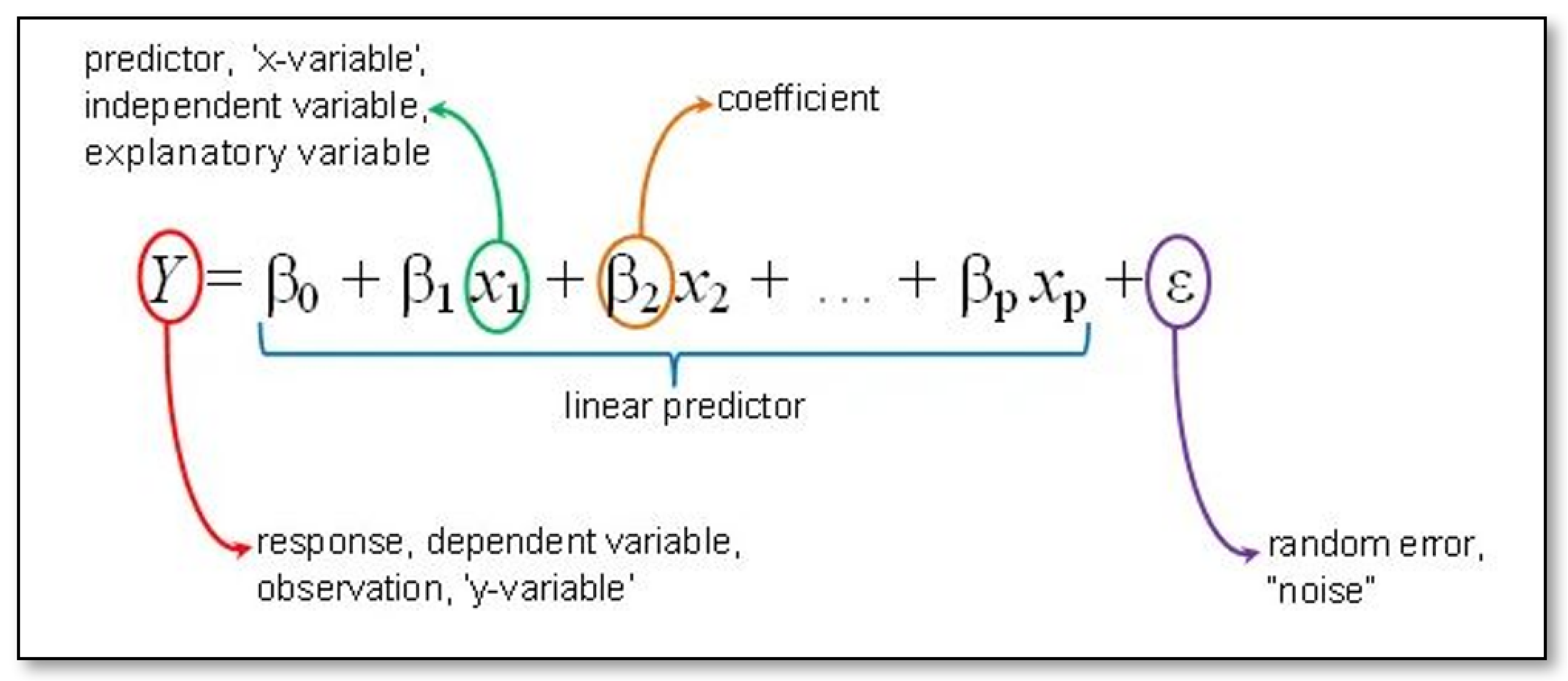
In this study, we employed linear regression, a robust statistical technique for modeling relationships between variables, to predict olive productivity based on changes in precipitation and temperature [
33]. Using both Ordinary Least Squares (OLS) and Geographically Weighted Regression (GWR), we analyzed the impact of these climatic factors on olive yields. This dual approach allows for the examination of local variations in relationships, enhancing our understanding of how environmental factors influence agricultural outputs in different regions [
34]. The equation as shown in
Figure 4 describes how the predicted values of y are related to p independent variables and is called a Multiple Linear Regression equation:
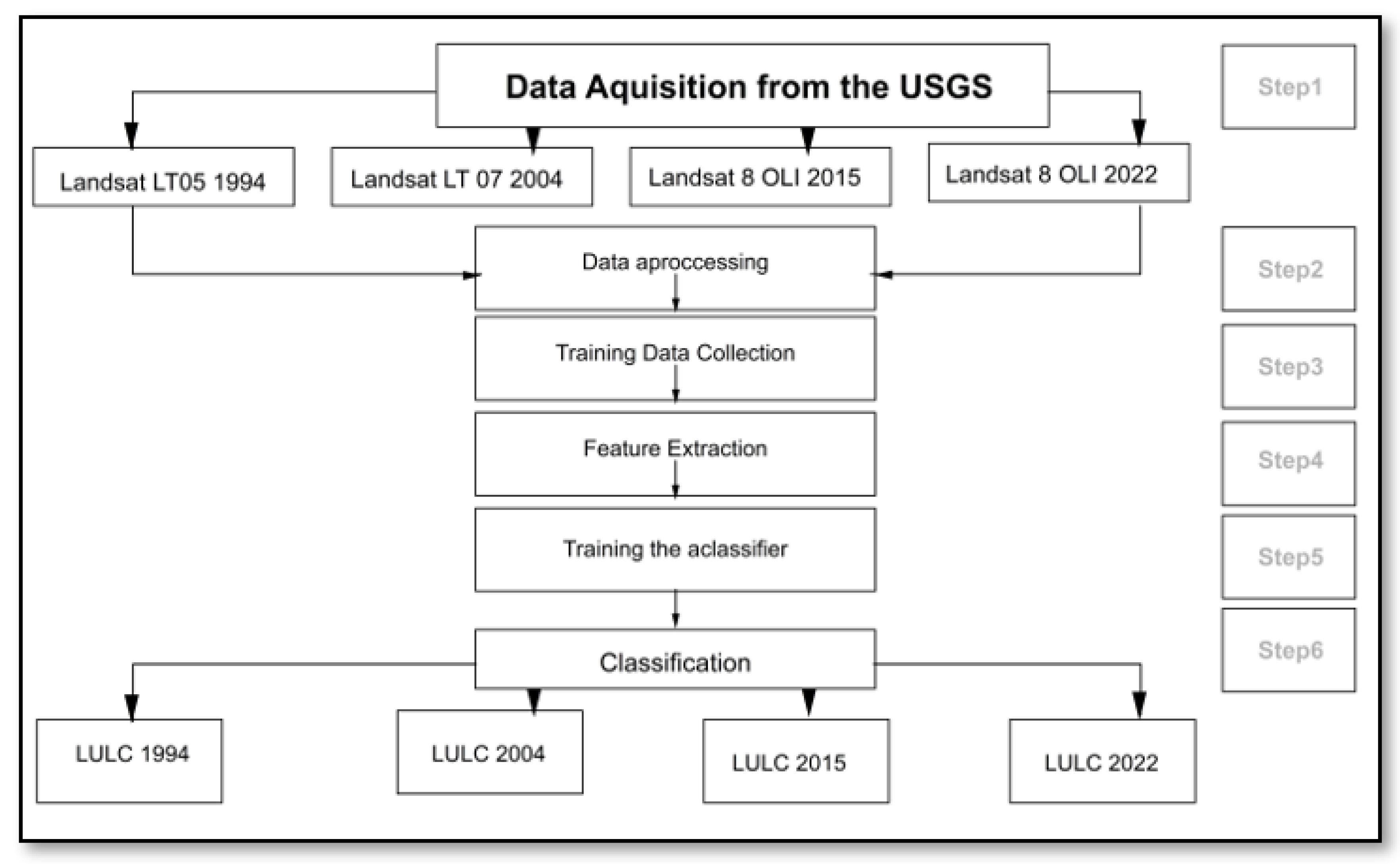
Figure 5 presents a flowchart illustrating the multiple linear regression analysis conducted in this study to predict the impact of climatic variables on olive productivity. This analysis integrates both Ordinary Least Squares (OLS) and Geographically Weighted Regression (GWR) methods to assess how variations in precipitation and temperature influence olive yields across different regions of Jordan. The figure outlines the sequence of steps from data acquisition to regression modeling, providing a visual representation of the analytical process that enhances our understanding of environmental factors affecting agricultural outputs.
In the context of olive production, this analysis seeks to understand how changes in these independent variables, like variations in precipitation and temperature, influence the quantity of olives harvested. By examining these factors together, we can assess the extent to which precipitation and temperature contribute to the overall variability in olive production. Multiple linear regression allows us to quantify and model these relationships, providing insights into how various environmental factors impact the yield of olive crops. In this context, the following figure illustrates the criteria used in calculating the regression equation over four time periods, 1994, 2003, 2012 and 2021, spanning a total of nine years (see
Figure 6).
On this consolidated dataset, we applied both Ordinary Least Squares (OLS) and Geographically Weighted Regression (GWR) analyses. Regression analysis is a statistical modeling technique used to uncover relationships between a dependent variable and multiple independent variables. Linear regression is the most commonly employed method in geographic analysis. However, it may overlook non-stationary variations, especially in the case of global fitting methods like OLS. In contrast, GWR offers an alternative approach by taking spatial variations into account. GWR allows for localized variations in coefficient estimation, leading to unique regression coefficients for each location. The key advantage of GWR is its ability to identify select attributes from a vast pool of potential criteria that significantly impact these attributes, thereby ranking them according to their significance.
Before commencing with OLS, we assessed multi-collinearity among the variables using Variance Inflation Factor (VIF) scores, employing the exploratory regression tool in ArcGIS software. By theory, multi-collinearity poses a problem for estimation when the VIF score exceeds 7.5. To mitigate potential misinterpretations, we removed local products from the analysis. Additionally, we checked for spatial autocorrelation using Moran’s Index to gain insights into how variables were spatially distributed. As a final step, we conducted GWR to visualize the spatial distribution of attractive sites. Several models were examined with the assistance of ArcGIS software (
Table 6).
3. Results
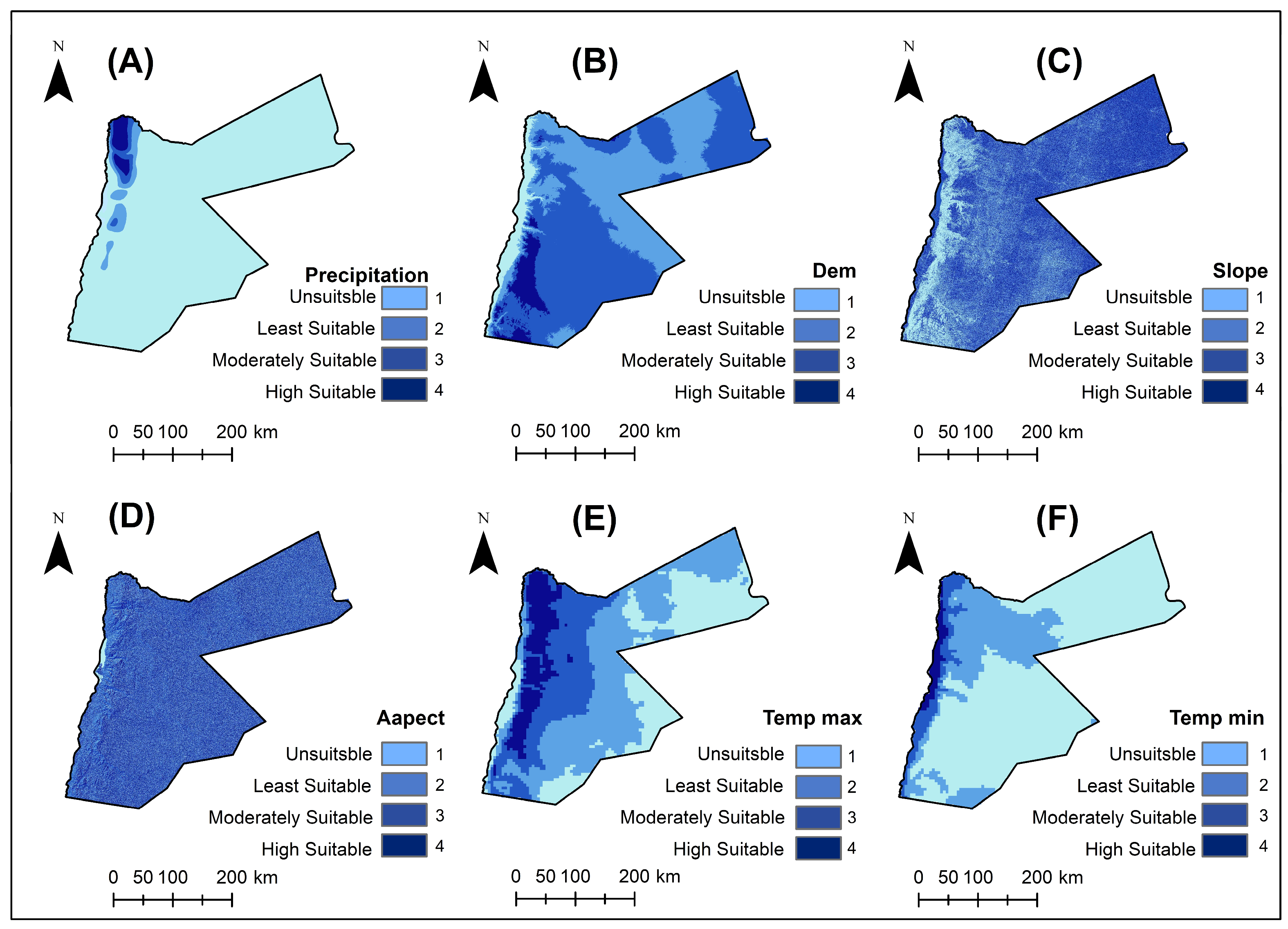
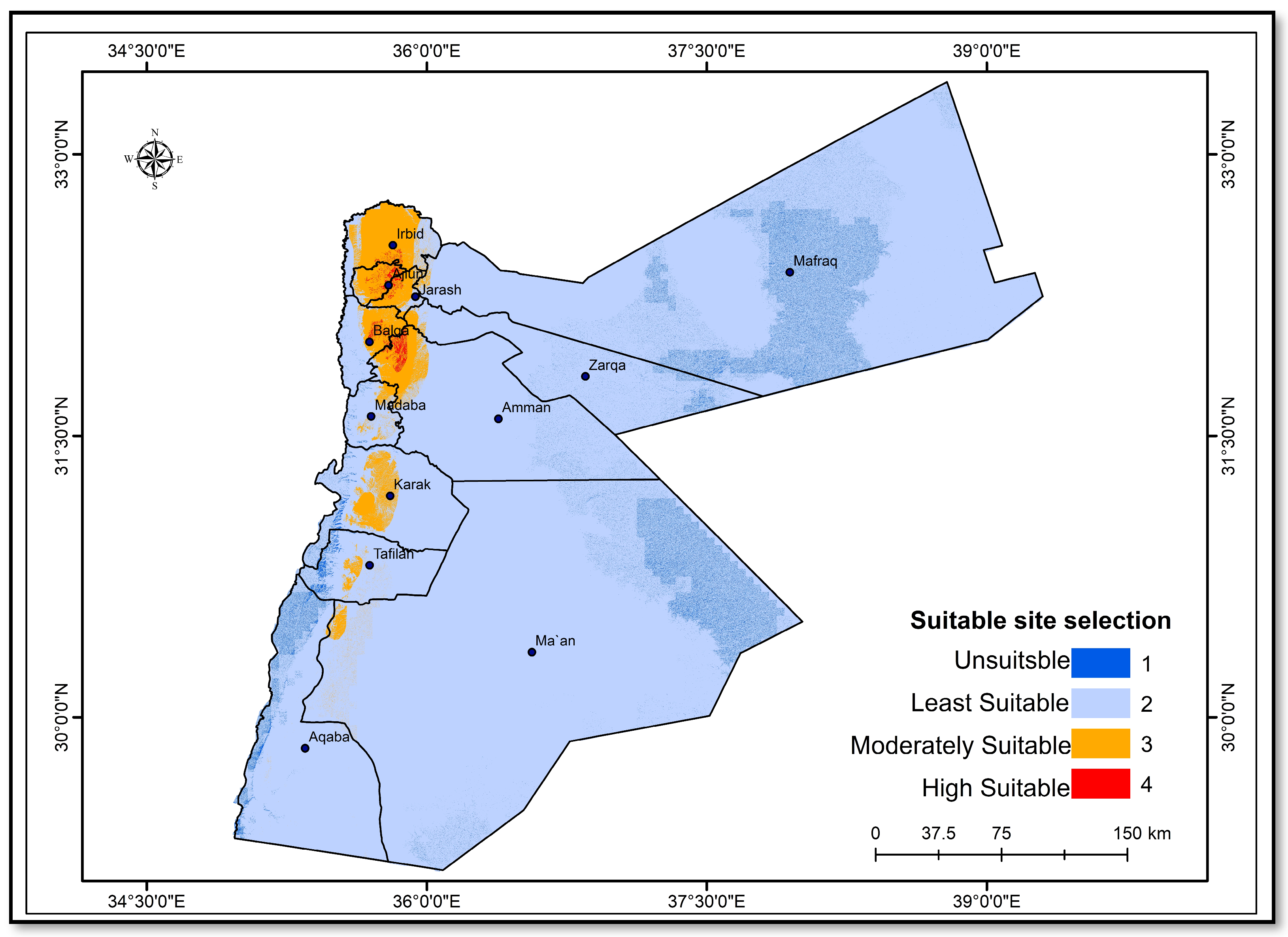
The suitability map for olive tree cultivation in Jordan encapsulates an integrated analysis derived from the preceding thematic maps (
Figure 7), providing a holistic view of the most viable regions for olive farming (
Figure 8). This map categorizes the land into four distinct suitability classes, unsuitable, marginally suitable, moderately suitable and highly suitable, based on a composite assessment of climatic and topographical parameters such as precipitation, temperature, aspect, slope and altitude.
Highly Suitable Areas: These regions, predominantly located in the northern and western parts of Jordan, coincide with areas of higher annual precipitation (300–600 mm) and moderate temperatures that avoid the extremes of both winter frost and summer heat. These areas also benefit from favorable northwestern aspects and gentle to moderate slopes, optimizing olive tree exposure to sunlight while minimizing water runoff and soil erosion.
Moderately Suitable Areas: Surrounding the highly suitable zones, these areas exhibit slightly less optimal conditions, either due to reduced precipitation, higher maximum temperatures or less ideal slopes and aspects. However, they still maintain adequate conditions for olive cultivation, requiring perhaps more intensive management practices such as irrigation and soil conservation measures to enhance productivity.
Marginally Suitable Areas: These areas typically face challenges such as lower precipitation (below 300 mm annually), higher elevation, steeper slopes or unfavorable aspects. Olive cultivation in these zones is possible but would require significant adaptations such as controlled irrigation, terracing to manage slopes and careful selection of olive varieties that can tolerate specific microclimatic conditions.
Unsuitable Areas: Primarily found in the extreme desert regions of eastern and southern Jordan, these areas are characterized by very low precipitation (less than 50 mm annually), high temperatures and often extreme slopes or unfavorable aspects for olive cultivation. The limitations in these regions make commercial olive production unfeasible under current climatic conditions.
This suitability map serves as a critical tool for agricultural planners, farmers and policymakers, guiding the expansion of olive cultivation in Jordan in a manner that aligns with sustainable agricultural practices and climate resilience. By focusing on areas identified as highly or moderately suitable, investment in olive cultivation can be optimized to achieve higher yields and better quality, ensuring economic viability and environmental sustainability.
4. Discussion
The results presented in this study highlight the northern and western regions of Jordan as the most suitable for olive farming due to favorable climatic conditions, including adequate precipitation and moderate temperatures. This aligns with findings from other Mediterranean regions, underscoring the critical role of balanced microclimatic conditions in olive tree productivity and sustainability. Arenas-Castro et al. [
13] emphasize the importance of climate in determining the suitability and productivity of olive varieties, particularly in southern Spain where climate change is expected to decrease the suitability and production of olive varieties. Similarly, Fraga et al. [
11] review future impacts and adaptation strategies for Mediterranean olive orchards under climate change, highlighting the need for adaptive measures to sustain olive production.
Our suitability analysis through the AHP method reinforces the importance of a multi-criteria decision-making framework in agricultural planning. This approach captures the complexity of ecological variables affecting crop viability and allows for weighting these factors according to their relative importance to olive cultivation. This methodological foundation is crucial for ensuring that agricultural development is both sustainable and adaptive to the evolving impacts of global climate change. This is consistent with the findings of Triantaphyllou and Mann [
26] who used the AHP method for decision-making in engineering applications, emphasizing its robustness in handling multiple criteria.
The increase in temperatures and changes in precipitation patterns documented in our climatic analysis are consistent with global trends observed to impact agricultural yields adversely. The adaptability of olive trees to these changes, highlighted by their resilience in moderately and marginally suitable areas, suggests the potential for genetic and agronomic advancements to enhance crop sustainability under stress conditions. Khateeb [
14] found a direct relationship between precipitation amounts and olive productivity at various stages of olive tree growth in the West Bank, which supports our findings on the importance of precipitation for olive cultivation. Furthermore, Rodrigo-Comino et al. [
17] identified that prolonged precipitation variability significantly influences olive production and farmer income in Spain, indicating similar challenges faced by olive farmers in Jordan.
However, the challenges remain substantial. Areas marked as unsuitable for olive cultivation—characterized by extreme temperatures, low precipitation and steep slopes—highlight the limitations of expanding olive agriculture into more arid regions of Jordan. These findings are pivotal for guiding future agricultural policies and practices focusing on water management, soil preservation and the selection of olive varieties better adapted to harsh environmental conditions. Gratsea et al. [
16] also underscore the significant challenges posed by climate change to olive production in Andalusia, Spain, particularly due to the risks posed by the olive fly, highlighting the need for strategic adaptation measures.
The findings of this study highlight significant regional variations in the suitability of olive-cultivation areas within Jordan. While northern and western regions exhibit high suitability, several areas remain unsuitable due to factors such as low precipitation, high temperatures and steep slopes. To address these challenges and promote sustainable development, targeted interventions are necessary.
One promising approach is the implementation of advanced irrigation systems, such as drip irrigation, which can enhance water-use efficiency and support olive cultivation in arid regions. Soil amendments, including the application of organic compost like can improve soil structure and fertility, making previously unsuitable areas more conducive to olive growth [
20].
Agroforestry practices, which integrate olive trees with other compatible plant species, can create a more favorable microclimate and improve soil health. Additionally, the development of drought-resistant olive varieties through selective breeding and genetic modification offers a long-term solution to climatic challenges.
The analysis used in this study provides a detailed spatial understanding of the factors affecting olive suitability. By leveraging this analysis, policymakers and agricultural planners can design localized intervention strategies that align with the specific needs and conditions of each region. This targeted approach ensures that efforts to convert unsuitable areas are both effective and sustainable, ultimately contributing to the resilience and productivity of Jordan’s olive-cultivation sector.
By incorporating these strategies and insights from previous studies, this research aims to offer a comprehensive framework for enhancing the suitability of currently marginal areas for olive cultivation, thereby promoting sustainable agricultural development in Jordan.
While this study primarily focuses on the Jordanian region, characterized by a subtropical desert climate and a subtropical Mediterranean-type climate, the multi-criteria decision-making framework based on GIS and AHP used in this research has the potential to be applied to other regions with similar climatic conditions. The robustness of the model lies in its methodological approach, which integrates climatic and topographical data to assess the suitability of areas for olive cultivation.
However, to further validate the scalability and robustness of the model, future research should consider applying this framework in different geographical regions. For instance, regions with Mediterranean climates, such as parts of Southern Europe, North Africa and California, could serve as comparative case studies. By applying the model in these areas, researchers can evaluate its effectiveness and make necessary adjustments to account for local variations in climate and topography.
Previous studies have demonstrated the feasibility of adapting agricultural suitability models to different regions. For example, [
19] analyzed the expansion of olive orchards in Cordoba, Spain, highlighting the role of intensive agricultural practices in transforming unsuitable areas into productive land. Similarly, Refs. [
20,
21] provided insights into soil management and water-use efficiency practices that could be adapted to different regions to enhance olive cultivation.
In terms of the reclassification process, it might appear subjective, yet, they are rooted in a comprehensive review of relevant literature and the practical expertise of researchers experienced with the local conditions. This method is consistent with established practices in geographic and agricultural research, where expert judgment and contextual understanding play a critical role in defining classification criteria.
Validation through Literature and Expertise
The classification thresholds used in this study reflect findings from multiple sources, ensuring their validity and relevance. For instance, [
19,
20] demonstrated that similar reclassification methods were effective in identifying suitable areas for olive cultivation in different regions. The parameters chosen and their respective thresholds were validated through cross-referencing with these studies, thereby reinforcing the robustness of our approach.
The current study employs a Geographically Weighted Regression (GWR) model to analyze the spatial relationships between climatic variables and olive-cultivation suitability. While the two-dimensional spatial approach provides valuable insights, we acknowledge the potential benefits of incorporating a temporal dimension to enhance the model’s robustness and predictive capabilities.
Integrating a time dimension into the GWR model to form a Space-time Geographically Weighted Regression (GTWR) model would allow for a more comprehensive analysis of how these relationships evolve over time. This three-dimensional approach not only examines the current relationships between the independent and dependent variables but also facilitates forecasting future trends, offering a more dynamic and long-term perspective on olive-cultivation suitability.
In addressing these challenges, this study contributes to the broader discourse on food security and agricultural resilience in arid and semi-arid regions. The methodologies employed can serve as a template for similar agricultural assessments in other parts of the world facing the dual challenges of climate change and resource scarcity. Kandel et al. [
18] illustrated the importance of using multi-criteria analysis combined with GIS to identify suitable areas for olive cultivation in Nepal, reinforcing the applicability of these methodologies in diverse geographical contexts.
To enhance the robustness and scalability of the model, future research should aim to:
Apply the Model in Diverse Regions: Test the model in various regions with Mediterranean climates to validate its scalability and identify region-specific modifications.
Evaluate Different Climatic Scenarios: Incorporate different climatic scenarios and predictions to assess the model’s robustness under changing conditions.
Incorporate Local Agricultural Practices: Adjust the model to include local agricultural practices and land management strategies that may influence olive-cultivation suitability.
Collaborate with Local Experts: Engage with local agricultural experts and stakeholders to refine the model based on regional knowledge and practices.
Develop and Apply a Space-time Geographically Weighted Regression (GTWR) Model: Integrate the time dimension with spatial coordinates to analyze temporal dynamics, forecast future conditions and enhance model robustness across different time scales and regions. This approach will provide more accurate predictions and inform adaptive strategies for future climatic scenarios, contributing to the sustainable development of olive cultivation.
5. Conclusions
The integration of Geographic Information Systems and the Analytical Hierarchy Process has been used in this study to understand the different environmental controls on olive cultivation in Jordan. Through detailed mapping and analysis of the distribution of important climatic and topographic variables, it has been possible to identify areas with a high potential for olive growing even under the restrictions of climate change. The northern and western parts of Jordan have shown to be particularly good about olive cropping, though indications of potentially good sustainable agricultural planning. This underscores the importance of strategies at the site level, combining environmental sustainability and agricultural productivity, in increasing the resilience of olive production to climatic uncertainties.
This study provides a comprehensive framework for identifying optimal olive-cultivation areas in Jordan amidst climate change. However, the true test of the model’s robustness and scalability lies in its application to other regions with similar climatic conditions. Future research should focus on validating the model in diverse geographical areas to ensure its broader applicability and to refine the decision-making framework for global use.
6. Recommendations
Future research should focus on the following critical areas in building on the findings of this study. Advanced modeling techniques, using the best-developed climate models and predictive tools to arrive at future climate scenarios accurately, can further detail suitability analysis and provide precision recommendations for agricultural practices. Such research about olive genotypes developed for better tolerance to temperature extremities and water scarcity could be a breakthrough in the cultivation of olives.
In future research, economic analysis should be incorporated as part of the assessment of the cost-effectiveness of various adaptation strategies for olive cultivation under changing climatic conditions to fathom the financial viability of such adaptive measures. This would further the exercise by operationalizing it at the local level by involving farmers, agricultural policymakers and community organizations in all the stages of planning and executing their projects, hence ensuring that the GIS and AHP analyses provide practical ways. In this way, the recommended practices can be quickly adopted.
Its application will also occur in other regions within the same climatic and topographical profile and will validate, by testing, the applicability and viability of the model. This will result in its general application to agriculture worldwide, thus improving the sustainability and robustness of olive growing. Exploration in these areas can significantly increase the sustainability and resilience of agricultural practices not only in Jordan but also in other world regions facing similar environmental challenges. This work will further contribute to food security and ecologic stability in arid and semi-arid areas. It presents a template for dynamic and adaptive agricultural planning.


